Mohammed F. Yass*![]() | Rasul M. Khalaf
| Rasul M. Khalaf![]()
© 2025 The authors. This article is published by IIETA and is licensed under the CC BY 4.0 license (http://creativecommons.org/licenses/by/4.0/).
OPEN ACCESS
The stability of riverbanks depends on several factors, such as soil characteristics, soil type, groundwater level, pore water pressure (positive and negative), water surface level, vegetation cover, and the slope of the riverbank. Therefore, it has become important to work on stabilizing the riverbanks through some precautionary measures that could help to prevent the riverbanks from collapsing. There are many classical mathematic approaches for calculating the stability of riverbanks based on the safety factor concept, which becomes feasible using several computer modeling software. Among the best reliable modeling used to calculate riverbanks' stability, the Bank Stability and Toe Erosion Model (BSTEM) remains the practical and accurate tool in the field compared to other approaches. This manuscript aims to review most studies that used the BSTEM in different river conditions and hydraulic statuses for calculating the stability of riverbanks.
bank stability, Toe Erosion Model, riverbank stability, water resources, Hec-Ras, safety factor
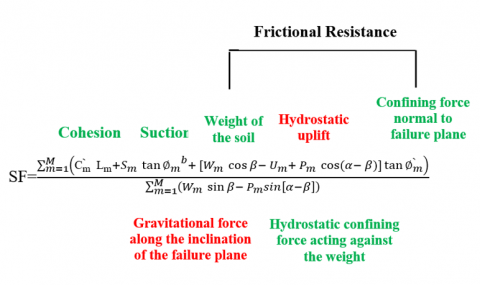
Riverbank stability is one of the most challenging topics in water resources engineering. Several infrastructures must be built close to the river due to their functionality. Therefore, a proper and stable riverbank should be secure and provided for these infrastructures. The riverbank stability depends on various factors, including the riverbank geometry, soil type and layers, pore water pressure, confining pressure produced by the river, and vegetation on the riverbanks [1]. The riverbank stability is measured by the safety factor concept, as shown in Eq. (1), which is defined as a ratio between the resisting force of the strength of the soil forming the riverbank and the driving force of the weight of the soil, including its moisture and geometry [2]. Figure 1 represents the typical forces acting on the river cross-section.
$SF=\frac{\sum_{m=1}^M\left(c_m^{\prime} L_m+S_m \tan \emptyset_m{ }^b+\left[W_m \cos \beta-U_m+P_m \cos (\alpha-\beta)\right] \tan \emptyset_m\right)}{\sum_{m=1}^M\left(W_m \sin \beta-P_m \sin [\alpha-\beta]\right)}$ (1)
In Eq. (1), the numerator represents the most terms of resisting forces, while the denominator represents the most terms of driving forces. Let's define the variables used in the equation. c represents the effective cohesion, S represents the matrix suction force, U represents the hydrostatic uplift, L represents the length of the failure plane, m represents the number of layers, W represents the weight of the soil block, β represents the failure plane angle, P represents the hydrostatic confining force of the water in the channel, α represents the channel side slope angle, $\varnothing_m{ }^{\prime}$ represents the friction angle and $\emptyset_{{ }_2}{ }^{\mathrm{b}}$ represents the relationship between matrix suction and apparent cohesion.
Figure 1. The typical forces acting on riverbanks
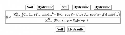
Figure 2. The driving and resisting forces of the layer method force balance equation
Figure 2 illustrates the specific components utilized to establish the force balance when employing the Layer Method. The driving forces are visually represented in red, while the resisting forces are depicted in green.
The soil characteristics play a major role in the effect of the safety factor through soil cohesion (C) and the friction angle (Ø) represented by the two terms ($\hat{C}_{\mathrm{m}} L_{\mathrm{m}}$) and ($\tan \emptyset_m^{\prime}$). In the numerator where the safety factor increases with increasing (C)(Ø) of the soil. The pore water pressure is divided into positive and negative, where the positive pore water pressure hurts the safety factor and appears in the numerator in the term (Um) among the driving forces that reduce the safety factor, while the negative pore water pressure has a positive effect on the safety factor and appears in the numerator in the term ($S_m \tan \emptyset_m{ }^b$) among the resistance forces that increase the safety factor. The weight of the soil affects the safety factor where analysis of the weight of soil (w) into two components, one of which is horizontal (parallel to ground surface) and appears in the numerator in the term Wm cosβ among the resistance forces that increase the safety factor, and the other component is vertical (perpendicular to the ground surface) and appears in the term Wm sinβ among the driving forces in the denominator that reduces the safety factor. Hydrostatic confining affects the safety factor, as the resulting force from the hydrostatic confining Pm is analyzed into two components, which are horizontal (parallel to the ground surface) and vertical (perpendicular to the ground surface), where it appears in the numerator in the term (Pm cos(α-β)) and appears in the denominator in the term (Pm [α-β]) among the resistance forces that increase the safety factor.
The forces outlined in Figure 2 can be classified into two distinct groups: soil forces, which consist of factors such as the weight of the soil block and cohesion, and hydraulic forces, which encompass hydrostatic confining forces and pore water pressure. These two categories encompass the various forces considered in the equation.
Figure 3 incorporated within the layer method force balance equation, presents the representation of hydraulic and soil forces. It depicts the combined effects of both hydraulic forces and soil forces within the equation.
Figure 3. The hydraulic and soil forces of the layer method force balance equation
Riverbank stability may be evaluated using several approaches, such as the limit equilibrium. With the limit equilibrium approach, the safety factor of a riverbank may be found for given specific conditions [3]. Many studies try to find the stability of river banks simply by the assumption that there are only possible planar failures by neglecting the relationship between confining pressures and pore water pressure [4]. Several numerical and experimental studies were carried on to investigate the phenomena of riverbank instability because riverbank failure can happen for many reasons, including fluvial toe erosions, decreased soil shear strength caused by increasing pore water pressure in the soil, and seepage. However, one of the well-known models to examine the stability of riverbanks is the Bank Stability and Toe Erosion Model (BSTEM), which the National Sediment Laboratory in the United States Department of Agriculture (USDA), Agricultural Research Station (ARS) established [5].
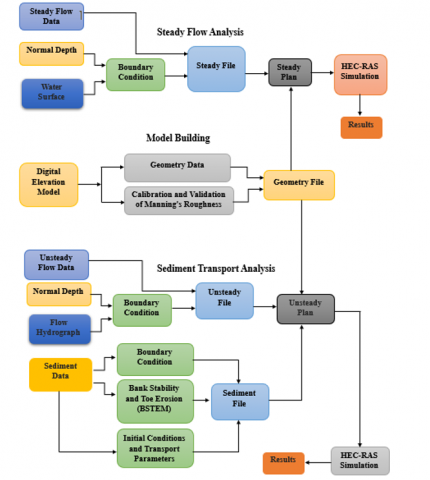
To understand the nature of the work of the HEC-RAS program and the BSTEM subprogram and how to enter data into it, the following flowchart was created to demonstrate this in Figure 4.
Figure 4. Block diagram of the stages of data entry in the HEC-RAS program and the BSTEM program
The most of the models discoursing the riverbank stability concern, as well as protect these infrastructures from floods [6, 7], might utilize the same concept of the riverbank safety factor, scientists have historically worked to develop and apply different cases of study to ensure the best fitting predictivity for riverbank stability under different hydraulics scenarios [8].
Thus, this work will represent some of the most accurate and modern applications for the BSTEM of riverbank stability.
Many studies are conducted on different hydraulic models to evaluate riverbank stability. Most studies utilizing the riverbank stability model are reviewed in this portion.
The BSTEM was implemented on the riverbanks of Little Topashaw Creek and Goodwin Creek, northern of the Mississippi River in the United States, to evaluate the effectiveness of seepage undercutting concerning other factors such as the shear strength in the soil of the riverbank, the angle of a riverbank, pore-water pressure of the soil, and a strengthening of the roots. The results show that seepage undercutting must be considered for riverbank stability because the shear strength of the soil is reduced when the soil conditions are saturated. This decrease leads to higher instability produced by undercutting. Also, the results indicate that the predicted safety factor dropped as pore water pressure in the soil, undercutting distance, and the riverbank angle increased. Also, the safety factor decreased linearly with rising water table elevation compared to the seepage level [9].
Another study determined the influence of various vertical root distributions on the riverbank by checking the safety factor. Several survey and field data were considered regarding the effect of regional changes in the root density with depth on riverbank stability. The root strengthening estimations produced by RipRoot were accurately applied to the layering inside the BSTEM. A riverbank profile was modeled with three different root distributions, each approximating the same average root reinforcement across the top of the riverbank profile. The results indicated that the safety factor of the riverbank changed most when the ratio of failure plane length to rooting zone depth was the largest [10].
For multiple cross-sections of the Lower Osage River downstream of the Bagnell dam in the United States, assessment of the possible impacts of different hydropower flow scenarios on erosion and riverbank stability. The calibrated and validated BSTEM was implemented over 13 cross-sections along the reach from May 2001 to October 2001 into six different outflow scenarios. Four of the thirteen cross-section positions were provided with wells to monitor groundwater inside the riverbanks. Based on the study's findings, the Osage River's riverbanks are relatively stable if ignoring toe erosion from noncohesive material. However, many riverbanks become unstable during outflow situations when erosion is considered, and the most likely failure mechanisms in the riverbank are mass wasting or cantilever collapses [11].
For estimate the level of uncertainty for the BSTEM hydraulic model. The Osage River is used as the case study for this investigation of BSTEM. In this research, the analytic techniques use four distinct components that must be evaluated to establish with certainty the optimal statistical model for each dependent variable. The first one is the Relationships Verifying (F-test), the Second one is the determination coefficient (R2), the Third one is the Error Squared Mean (MSE), and the fourth one is the Mallow's Cp. To evaluate the uncertainty of the BSTEM, four different outputs were taken from the program results, and their uncertainty was studied. These four dependent variables are the safety factor (SF), the maximum lateral retreat, the total eroded area, and the average applied boundary shear stress. The findings indicate that the examination of the safety factor provided indecisive results; however, the confidence levels for the other three factors ranged from 76.7% to 90.6%, with an average confidence level of over 80% for the complete BSTEM [12].
The BSTEM was used effectively to perform three goals in stream restoration applied to the Big Sioux River, located in South Dakota the United States. Estimating the yearly erosion rates of the riverbank, evaluating the relative importance of erosion in the riverbank to other types of corrosion, and assessing the efficacy of various measures for mitigating riverbank erosion were the main goals of this study. The finding of the BSTEM indicated that the amount of suspended sediment that comes from stream riverbanks is subject to a wide range of variations. In fact, toe hydraulic erosion only accounts for 15%-20% of total riverbank erosion. Thus, modeling of stream riverbank mitigation techniques suggests that adding toe protection to deteriorating stream riverbanks may lower overall quantities of erosion sediment transport by up to 85% [13].
Few model assessments have utilized long-term riverbank retreat data. Therefore, the knowledge of the dynamic for the pressure of pore water, the distributions of shear stress, and approaches for estimating surplus shear stress components for noncohesive soils were applied using BSTEM and other stream riverbank stability models. The study focused and applied on the riverbank of Barren Fork Creek River located in northern Oklahoma of the United States. The observation of the long-time composite riverbank retreat on a quickly flowing stream during a hydraulically active period was addressed by assessing the BSTEM's ability to forecast recorded riverbank retreat and identify the significance of exact geotechnical, fluvial erosion and properties of pore water pressure in the riverbank. The results showed that the reaction of the water table in the stream riverbank had a significant impact on the riverbank stability. Further work has to be done to develop BSTEM to improve its ability to predict the dynamics of the pore-water pressure near the riverbank [14].
The BSTEM has been utilized to calculate critical parameters such as vegetation that impact riverbank erosion and collapse and to predict retreat rates over time. For this purpose, creating and using more accessible methods for calculating root cohesion inside the riverbank, evaluate the model's sensitivity to root cohesion and its accuracy in estimating retreat by applying BSTEM to a set of ten composite riverbanks along the Barren Fork Creek located in eastern Oklahoma of the United States. Results showed that the lateral retreat at the ten sites studied varied from 4.1 to 74.8 m, with the highest retreat occurring at the historically unprotected locations (averaging 49.2 m). Less riverbank retreat occurred in protected areas, although the annual retreat rates varied significantly. In addition, the capability of tree roots to decrease erosion was a significant benefit of stream riverbank tree cover [15].
The impacts of tension cracks and varying flow depth on riverbank stability are analyzed to indicate that BSTEM is a suitable model for monitoring and measuring the riverbank state throughout a restoration procedure. As a case study, Different flows and tension cracks were tested on the left and right sides of the riverbanks of Yonaba Creek of Mississippi State in the United States. The results showed that high flow rates and larger tension cracks cause the greatest retraction. In addition, evaluating root strengthening indicate that the riverbank may get higher stability with root reinforcement. Therefore, the vegetation cover is of considerable importance to the riverbank's stability and must be considered in restoration efforts [16].
The stability of the riverbank and toe erosion was simulated with two different soil moisture scenarios for three sites along the Tigris River at Numaniyah city in Kut-Iraq using the BSTEM. This study implemented the hydraulic characteristics of Tigris River flow during the period from Sep. 2017 through Feb. 2018. For the first scenario, the moisture content of the riverbank's layers was assumed to be changed between three different values. While in the second scenario, three various moisture contents were assumed for the whole riverbank. The finding showed that dry and optimal soil moisture contents produced more erosion than wet riverbanks, which in both cases, more erosion and instability can occur downstream of Numaniyah City than upstream of the Kut barrage [17].
Inspecting the combined impacts of riparian vegetation (root cohesion), tension crack, seepage erosion, and land use/land cover variation on the stability of riverbanks along the Iju River in Nigeria during the dry and wet seasons was applied using the BSTEM. More than fifteen points along the river channel were used to collect data on the riverbanks' geometric and geomorphological features, including the riverbank face length, riverbank height, maximum riverbank full depth, riverbank angle, tension crack depth, and root depth to be used in the riverbank stability model. Results of the BSTEM showed that when the seepage undercutting distance increases, the safety factor decreases regardless of the riverbank angle. Further, the correlation analysis between the safety factor, root cohesion, and tension crack reveals a positive connection between the safety factor and root cohesion. In contrast, a negative correlation between the safety factor and tension crack. The loss of vegetation and wetlands inside the study area has negatively affected rivers' natural flow regimes with commensurate growth in the size of the built-up area and agricultural land or open areas [18].
The riverbank stability was examined using the BSTEM algorithm, which was integrated into the HEC-RAS model package. The study focused on assessing the impacts of water releases from the Bagnell Dam by calculating safety factors for 78 cross sections along the 130 km lower Osage River in Missouri, USA. The results show that the flow magnitude rate change at each cross-section affects the computed safety factor. Flow release changes will alter the safety factor value throughout the river over time since the safety factor value closely follows the flow rate variation. In addition, the findings indicate that the cross sections closer to Bagnell Dam are more susceptible to instability than those farther downstream of the Osage River [2]. Also, the effect of the peak flow duration in the river and the ecological low flow and the duration of their continuity for the same study area was verified in another study. The results showed a high impact of the sudden drop in discharge on the stability of riverbanks [19].
The morphodynamic alterations occurring within this particular meander bend and the trajectory of the potential development of a neck cutoff caused by the process of riverbank erosion were investigated by utilizing the BSTEM. The distant segment of the Lower Jingjiang River within the central Yangtze River in China was used to implement as a case study. The result showed that an increase in the erosion process could accelerate riverbank erosion, potentially leading to a neck cutoff in the coming decades. This has the potential to significantly disrupt the quasi-equilibrium state of channel morphodynamics within the Lower Jingjiang River [20].
The assessment of riverbank stability along the Rönne in Ängelholm of Sweden was implemented using the BSTEM. The main aims of this work included developing a hydrodynamic model, modeling sediment transport inside the river, assessing the variables that define sediment transport, mapping out eroded stretches, and finally evaluating riverbank stability in the most eroded stretches. The results of the BSTEM showed that some cross-sections along the mentioned river would have a safety factor value less than an accepted value which makes them subjected to failure and collapse. In contrast, the status of most cross-sections will be in the safe zone. Furthermore, the sediment transport model calculated annual erosion rates of 197.8 tons in the upstream watershed and annual deposition rates of 206.25 tons in the downstream catchment [21].
Empirical connections drawn from measured soil properties for the Cottonwood River of Kansas in the United States were employed to acquire the essential soil properties necessary for riverbank stability analysis. The soil characteristics derived from both consolidated undrained and unconsolidated undrained triaxial tests were compared to the default soil properties of the BSTEM. The results showed that using soil properties from total stress analysis or based on soil classification led to more conservative yet reasonable safety factors. The study recommended future enhancements to BSTEM to include an option for total stress analysis, thus providing a more comprehensive and conservative evaluation method [22].
This paper investigates riverbank collapse, a common occurrence in natural rivers. It focuses on the quantitative analysis of the effects of soil properties and riverbank inclination using the Bank Stability and Toe Erosion Model (BSTEM). The study aims to investigate riverbank collapse, a common phenomenon in natural rivers. The objective is to quantitatively analyze the effects of soil properties and riverbank inclination on riverbank stability. The study uses the Bank Stability and Toe Erosion Model (BSTEM) to assess the stability of homogeneous riverbanks with different inclination angles and binary structure riverbanks composed of different materials. The results reveal distinctions in cohesive and non-cohesive riverbank collapse modes, disregarding the water table. The internal friction angle dominates non-cohesive riverbanks, while cohesive riverbanks are influenced by effective cohesion. Safety factor and water depth variations follow a quadratic law, especially in non-cohesive riverbanks. Increased inclination reduces stability, emphasizing the importance of lower material properties in binary riverbanks [23].
This study delineates the bank erosion modeling focusing on HEC-RAS Sediment Modeling within the comprehensive Old, Mississippi, Atchafalaya, and Red (OMAR) Rivers System Technical Assessment. The primary objective was to assess the comparative impacts of diverse flow scenarios on riverbank retreat along a specified stretch of the Atchafalaya River, ranging from Simmesport, LA, to the Whiskey Bay Pilot Channel. The methodology involved compiling field and soil data, selecting bank retreat sites, creating representative soil profiles, calibrating soil parameters based on measured retreat rates, and modeling bank retreat and eroded material volume under various flow scenarios. The study's intended purpose for scenario comparison is emphasized, cautioning against precise predictions of bank erosion rates. The finding underscores the substantial impact of varying the flow from the Mississippi River into the Atchafalaya, which could significantly alter the extent of riverbank erosion compared to the existing management scenario [24].
Riverbank erosion results from the intricate interplay between the flowing water's hydraulic action and the geotechnical stability of the riverbank. This study employs BSTEM to assess short-term riverbank stability, integrating factors like vegetative cover and water table effects in a selected area along Sg. Bernam. Field measurements encompass riverbank profiles, soil samples, hydraulic parameters, and vegetation properties. Scenarios, including vegetative cover and water table variations, are applied to quantify erosion magnitude and bank stability. The analysis reveals improved riverbank stability with vegetative cover and highlights BSTEM's efficacy in assessing short-term riverbank toe erosion and safety factors [25].
Experimental work was held on riverbanks along the Sieve River in Italy to investigate the influence of negative pore water pressures and their relation to the safety factor concept. Different apparent cohesion values were used to generate a stability chart, and the impacts of flow events were included in a stability analysis. Then, the riverbank geometry and the material shear strength were employed to represent the safety factor. Hence, changes in the safety factor over time are demonstrated as a function of water suction within the riverbank for seasonal changes [26]. The finding of this study was compared later to the BSTEM and showed a great matching of the predicted behavior of the BSTEM to the results of the experimental work [27].
Analyzing pore water pressure variations and their influence on riverbank stability along the Sieve River through four years. Several piezometer tension meters were used to monitor the water table level by modeling a seepage analysis utilizing finite elements. The results would allow the opportunity to show how changes in both negative and positive pressures in pore water may affect the riverbank's stability. The safety factor concept was applied using a limit equilibrium approach and a model of saturated and unsaturated flow, presenting the possibility for analyzing riverbank failure processes and evaluating the safety factor indicating how the riverbank responds to different flow events under varying hydrologic conditions and riverbank geometries. The results obtained from the seepage and stability study of nine various flow events were utilized to evaluate the effect that flow event features and variations in riverbank geometry are involved in the process. In addition to the highest river flow, which significantly impacts when instability situations occur. The properties of the hydrograph are important, especially in the occurrence of a small peak or peaks in the river stage before the major peak [28].
A physically-based model was presented, which assesses the safety factor of riverbanks, including several layers. The model accounts for the positive influences of pore water pressure in the riverbank's saturated region and the negative in its unsaturated region. In addition, the impact of the pressure from the hydrostatic confining results from the river's changing water level. As well as the impacts of the water in the tension crack are also considered in the stability analysis. The validity of this model through the use of field data sets collected from a location on the Sieve River in Italy and Goodwin Creek in Mississippi in the United States. The findings showed some degree of concordance between the expected values and those observed regarding riverbank stability [29].
Experimentally, three scenarios of unsteady flow are simulated using an advance finite element methodology based on the safety factor concept. The effects of these flows on riverbank stability are examined. The first scenario assumes a steady river level; the second fill the river to the top of the riverbanks; and the third involves a water drawdown. The two drawdown strategies, rapid and gradual, are analyzed. The finite element model of saturated, unsaturated seepage flow was de-coupled from a plain strain elastic-plastic finite element model using a strength reduction approach. The findings indicated that a saturated riverbank has a safety factor of approximately 83% compared to its dry state in the studied scenario. Filling the river was the most effective in stabilizing the riverbank. During the slow drawdown, the minimum safety factor occurred when the water depth was approximately 0.25 to 0.3 the bank height. Conversely, the rapid drawdown was identified as the most critical situation for riverbank stability [30].
Another experimental work on riverbank stability compared to the Finite Element Method based on the safety factor concept methodology. The stability of a riverbank in the study was subjected to be under five distinct flood hydrographs and three different bed conditions. Seepage flow, slope stability, and hydraulic fluvial erosion models are coupled to analyze the influence of riverbed deformation and seepage flow on riverbank stability. The seepage numerical model predicts how the pore-water pressure and groundwater level inside the riverbed will change over time and space. The stability model evaluates the potential failure plane and determines the safety factor of the riverbank material. The fluvial erosion model is utilized to predict the boundary shear stress distribution over the cross-sectional area of a riverbank, therefore enabling erosion prediction. The study correctly predicted failure planes, safety factors, collapse timings, riverbank geometries, and pore water pressure for varied flood hydrograph patterns [31].
Laboratory work was conducted to study the influence of the fallen riverbank on the re-collapse of these riverbanks. The research focused on cohesive and noncohesive homogeneous riverbank failure processes in a straight and meandering channel due to fluvial hydraulic force. The study showed that the collapse of a noncohesive riverbank often occurs at the water's surface. In contrast, failure of a cohesive riverbank typically occurs towards the riverbank's toe, which would perfectly fit the safety factor concept theory. Also, the study showed that in noncohesive soil, the amount of erosion on the riverbank and the remaining quantities of failed bank soil on the riverbed increase with the near-bank flow velocity and the erodibility of the riverbed. While, in the situation of cohesive soil, only the quantity of erosion bank adheres to the described pattern. The findings are predicted to assist as a theoretical base for managing rivers and preventing floods [32].
The safety factor concept methodology was coded using the computer language Python and the Tkinter package to determine the safety factor for the Kansas River of the United States. The effects of various hydrologic circumstances brought on by various hydrologic and climatic factors were the primary goal of this study to analyze the extent to which these water management decisions, especially operations at reservoirs, impact the stability of riverbanks. The results suggested that various decisions about water management may have a detrimental effect on riverbank stability. These decisions may alter the pressure of pore water, the weight of the soil on the riverbank, and the erosion status in the riverbanks [33].
By reviewing most of the research that studied the stability of the riverbanks, we can take each study's advantages and lacks separately to form a good overview of the issue of the stability of riverbanks. Therefore, the following listed the main advantages of the previous studies and the limitations and lacks of previous studies.
3.1 Advantages of previous studies
Analyzing seepage effects on riverbank stability, considering factors like shear strength, pore-water pressure, riverbank angle, and root reinforcement, enhances erosion control and optimizes design for improved stability and durability [9].
It develops a more accurate and efficient method for modeling the stability of riverbanks reinforced with roots using algorithmic approaches [10].
Employing the BSTEM and evaluating varied release scenarios, identifies critical outflow patterns contributing to riverbank erosion, the findings provide essential insights into the nuanced relationship between release patterns, erosion dynamics, and riverbank stability, offering informed decision-making support for landowners, policymakers, and dam operators. Additionally, the study lays a scientific foundation for refining hydropower release strategies and considering protective measures, with the aim of minimizing deleterious effects on riverbanks and advancing sustainable river management practices [11].
It determines the level of uncertainty in the hydraulic model of the Osage River. It analyzes the Bank Stability and Toe Erosion Model (BSTEM) using statistical methods to determine the best-fit models for various dependent variables, including average applied boundary shear stress, safety factor, maximum lateral retreat, and eroded area. The results of the analysis provide insights into the variables affecting the BSTEM and determine the level of confidence in the model, with an average confidence level of over 80% [12].
It estimates the yearly erosion rates of the riverbank. The model has been proven to help evaluate the impact of proposed mitigation strategies to lessen the occurrence of riverbank instability and minimize sediment loads from riverbanks. Therefore, the results of this study refer to the modeling of riverbank mitigation techniques suggesting that adding toe protection to deteriorating stream riverbanks may lower overall quantities of erosion sediment transport by up to 85% [13].
The study is important for predicting lateral retreat on composite riverbanks. It assessed BSTEM's accuracy in predicting actual retreat and the influence of geotechnical, erosion, and pore-water pressure properties. The research identified significant retreat periods, highlighting storm events' impact on instability. By comparing default and measured soil parameters, the study revealed BSTEM's limitations in underestimating retreat, particularly without delayed water table responses. The findings emphasized the need for an improved understanding of shear stress distribution, pore-water pressure dynamics, and accurate parameter estimation for noncohesive soils, enhancing riverbank stability models like BSTEM [14].
It provides a quantitative method for evaluating the effectiveness of different riverbank protection strategies in reducing erosion and failure. Additionally, the study could help to identify areas that are at high risk for erosion, and failure, and prioritize resources for protection and restoration efforts. Also, the research quantifies the effects of riparian conservation practices on riverbank retreat rates. The study's innovative approach of estimating root cohesion based on biomass estimates enhances the model's accuracy. Through careful calibration and comparison with observed retreat data from aerial imagery, the study establishes BSTEM's efficacy in predicting riverbank retreat, especially for highly variable and episodic erosion events on composite riverbanks [15].
By considering various flow depths and tension crack scenarios, the research provides actionable insights for stream restoration efforts. Through BSTEM's application, the study showcases the effectiveness of this model in quantifying riverbank conditions and evaluating stability under different conditions. The identification of critical factors such as flow rate and tension crack highlight their influence on riverbank retreat. Furthermore, the study emphasizes the importance of vegetation for riverbank stability. Also, it helps in designing strategies to counter erosion and bolster stability [16].
It provides a comprehensive analysis of Tigris Riverbank stability in Southeast Baghdad City. Through the application of BSTEM and consideration of different moisture scenarios. Also, it can provide a comprehensive understanding of the different factors affecting the stability of the Tigris Riverbanks, including erosion, water flow, and sediment deposition, which can be used to develop effective management water and conservation strategies [17].
It offers valuable insights by incorporating multiple aspects such as seepage erosion, riparian vegetation, tension cracks, and land use changes, the research provides a comprehensive understanding of the mechanisms driving riverbank erosion. The use of geotechnical analyses, remote sensing data spanning two decades and advanced models like BSTEM and BEHI enhances the accuracy of the findings. Moreover, the study's focus on the impacts of urbanization and anthropogenic activities on river hydrology and geomorphology fills a critical knowledge gap for effective watershed-scale natural disaster management in the region [18].
It offers a valuable contribution to understanding the impact of hydropower flow releases on riverbank stability. Utilizing an advanced model like BSTEM, the research provides a meticulous quantitative analysis of how different flow scenarios impact riverbank stability along a significant stretch of the river by calculating safety factors for numerous cross-sections. It identifies areas prone to instability due to flow variations. This data-driven approach equips river managers and regulators with actionable insights, enabling the implementation of targeted measures to safeguard vulnerable riverbanks. Furthermore, the study suggests the integration of optimization algorithms to adjust dam outflow hydrographs, thus minimizing potential instability effects. Through validation with field data, including cross-section geometry and flow measurements, the study enhances the credibility of its models and findings that can be used to protect the lands adjacent to the river from erosion [2].
It offers valuable insights by examining the unique phenomenon of erosion in the inner riverbank and deposition in the outer riverbank of the Qigongling Bend in the Lower Jingjiang River. By integrating aerial imagery, remote sensing data, and hydrological information, the research uncovers the complex interactions between anthropogenic activities, sediment transport, and riverbank protection measures. The study sheds light on the transformative impact of the Three Gorges Reservoir operation on the bend's morphodynamics, emphasizing the need to monitor and manage the evolving upstream riverbank conditions. Its findings extend beyond the specific case, highlighting the potential reversal of meandering river evolution due to intense human interventions, with implications for river management strategies worldwide [20].
The advantage of this study lies in its comprehensive approach to assessing riverbank erosion and stability. By combining hydrodynamic modeling, sediment transport simulations, and bank stability analysis. The study investigates key parameters influencing sediment movement and identifies erosive stretches along the river.
Notably, it compares findings to an earlier study, enhancing the reliability of results. Overall, this research contributes valuable insights for river management and decision-making processes, aiding in the sustainable management of riverbank erosion and enhancing the understanding of river dynamics [21].
The research thoroughly investigates the impact of different methods of obtaining soil properties on the BSTEM analysis. By conducting comprehensive laboratory tests and correlations, the study establishes that effective stress analysis using consolidated undrained triaxial tests yields the most accurate safety factor. It also highlights the appropriateness of using total stress analysis or mean values based on soil classification for a more conservative yet reasonable assessment. Moreover, the recommendation for including a total stress analysis option in future BSTEMs ensures enhanced representativeness of actual scenarios [22].
It comprehensively explores riverbank collapse using the Bank Stability and Toe Erosion Model (BSTEM). The study distinguishes between cohesive and non-cohesive bank collapse modes by assessing the influence of soil properties and bank inclination on stability. Identifying the dominant factors for each type of bank provides valuable insights. Applying a quadratic polynomial law to safety factor and water depth variations enhances predictive capabilities. Additionally, examining binary structure banks contributes practical knowledge, particularly emphasizing the crucial role of lower material properties in riparian stability. Overall, this study advances understanding and aids in effective riverbank management [23].
This paper offers a significant advantage by comparing different flow scenarios on bank retreat along a specified stretch of the Atchafalaya River. The study's holistic approach, incorporating field and soil data, site selection, soil profile creation, parameter calibration, and modeling under various flow scenarios using HEC-RAS Sediment Modeling, enhances the robustness of its findings. The practical application of the research provides valuable insights for river system assessments and management practices, particularly emphasizing the crucial impact of varying Mississippi River flow on bank erosion. The paper's transparency about its limitations contributes to a nuanced interpretation of its results, ensuring informed decision-making in river management [24].
Its integrated approach uses the Bank Stability and Toe Erosion Model (BSTEM) to assess short-term riverbank stability. The study provides a comprehensive analysis by considering the intricate interplay between hydraulic action, geotechnical stability, and environmental factors. Applying various scenarios, including the impact of vegetative cover and water table variations, enhances its practical relevance. Quantifying the Safety Factor based on stability modes adds a quantitative dimension to the findings. Overall, the study contributes valuable insights into short-term riverbank toe erosion, offering a holistic perspective for informed decision-making in riverbank management [25].
Advances understanding of riverbank stability in partially saturated soils, highlighting the role of negative pore water pressures and apparent cohesion, often overlooked in geotechnical analyses. The comprehensive approach integrates in situ tests, laboratory experiments, and geomorphological reconnaissance, resulting in a stability chart that considers variations in apparent cohesion due to matric suction. Accounting for unsaturated conditions and flow events, the analysis provides a more accurate representation of riverbank stability, particularly during rainfall and drawdown phases. The research refines insights into riverbank instability, emphasizing the importance of monitoring pore water pressures to validate and enhance geotechnical models [26].
It provides a detailed analysis of pore water pressure changes and their effects on riverbank stability during flow events. The study used a combination of monitoring and modeling techniques to gain insights into the causes of riverbank failure and the role of flow event characteristics and riverbank geometry in determining stability. The results of the study provide valuable information for understanding the interactions between river hydrology, riverbank stability, and pore water pressures, which can be useful for developing effective strategies for mitigating riverbank instability. Also presents further strengths by combining empirical observations and advanced modeling techniques. The four-year pore water pressure monitoring offers a robust dataset for assessing dynamic riverbank responses. The integration of finite element seepage analysis with stability assessment ensures a comprehensive understanding of flow-induced impacts [28].
The advantage of this study lies in its development of a new, physically based model that addresses the complex dynamics of riverbank stability. By considering various factors such as positive and negative pore water pressure, hydrostatic confining pressure, and the effects of water in tension cracks, the model provides a more comprehensive and accurate assessment of riverbank stability. The model can contribute significantly to predicting riverbank stability, enabling better estimates of erosion rates and sediment yield, and consequently aiding in informed decision-making in riverbank management [29].
It offers a significant advancement in understanding and assessing riverbank stability under unsteady flow conditions through the innovative use of decoupled finite element models. By combining a saturated-unsaturated seepage flow model with a plain strain elastic-visco plastic model. This approach provides a comprehensive analysis of the response of natural riverbank slopes to changing water levels and internal seepage conditions. The identification of critical hydraulic conditions, such as rapid drawdown, that significantly impact riverbank stability enhances the practical applicability of the study's findings. The ability to quantify the effects of saturation, drawdown rates, and other factors on safety factor provides valuable insights for managing and controlling water levels in rivers and reservoirs with earthen banks. By employing decoupled finite element models, this research contributes to a deeper understanding of riverbank stability under unsteady flow conditions, aiding in more informed decision-making for river management and engineering practices [30].
It provides a comprehensive numerical simulation approach that combines three critical factors fluvial erosion, seepage flow, and slope stability to assess the stability of riverbanks under various flood conditions. By integrating these models, the study successfully calculates key parameters like factor of safety, expected failure plane, collapse time, riverbank geometry, and pore water pressure, providing a holistic understanding of riverbank behavior during flood events. Additionally, the use of the finite element method with moving boundaries allows for a more accurate prediction of the riverbank's response to changing water levels and groundwater table. The results of the simulation also provide insights into the impact of various factors on riverbank stability, and the trend of the factor of safety over time is also presented. Overall, this study's approach and insights offer valuable guidance for riverbank management and flood risk assessment [31].
It offers a comprehensive understanding of the intricate relationship between bank erosion and near-riverbank bed evolution due to fluvial hydraulic forces. The experimental design of the study allows for the controlled observation and quantification of these processes, which can inform the development of improved predictions of riverbank erosion and near-riverbank bed evolution in natural rivers. The study may also contribute to the development of more effective riverbank protection strategies, as well as to a deeper understanding of the factors that influence riverbank stability in rivers. Also, a unique focus on both non-cohesive and cohesive riverbank failures contributes valuable insights into the role of soil type in the erosion process. These findings provide a crucial theoretical foundation for river management and flood prevention strategies [32].
It examines the relationship between water management decisions and riverbank stability. A module was developed to estimate riverbank stability using a safety factor approach. The study found that water management decisions can negatively impact riverbank stability by changing factors such as pore water pressure, soil weight, and erosion status. The results of the study could inform water management decisions to minimize negative impacts on riverbank stability [33].
3.2 Lack of previous studies
It may not apply to all types of soil and vegetation, and may not fully capture the complexity of riverbank stabilization. Additionally, it may not take into account all possible factors that can influence the stability of root-reinforced riverbanks, such as human activities or changes in the climate. The BSTEM program lacks consideration for root reinforcement in riverbank stability analysis. This omission ignores a very important aspect of the natural stabilization mechanisms. Thus, the model predictions may not accurately reflect the scenarios for changing the conditions, type, and strength of the existing vegetation of the riverbank [9].
May not take into account the long-term sustainability of proposed root reinforcement solutions, which can be costly and difficult to maintain over time. The solutions proposed may not be adaptable to changing environmental conditions such as changes in water flow and sediment deposition, making them less effective over time, and may not be scalable or suitable for large-scale projects, limiting their application [10].
The study's concentration on six predefined release scenarios may oversimplify the variability of dam operations and their effects. Ignoring potential downstream impacts on sediment transport and water quality might underestimate the overall environmental consequences. It is reliance on historical data introduces potential inaccuracies and simplifications in assessing the impacts of outflow scenarios on bank erosion. Limited groundwater data hinders a complete understanding of erosion dynamics, while the study's narrow scope of analysis could introduce uncertainties and prevent a comprehensive understanding of the broader implications of hydropower operations on both the river's stability and ecological health [11].
The reliance on statistical analyses alone might not fully capture the complexity of hydraulic systems and their behavior. The study only considers four dependent variables, which may not provide a comprehensive understanding of all the sources of uncertainty in the model. The focus on specific statistical measures, while valuable, could omit other critical factors influencing model uncertainty, such as the accuracy of input data and assumptions made during modeling. Moreover, the inconclusive results for the safety factor analysis raise questions about the comprehensive effectiveness of the model's uncertainty assessment. The statistical analysis and software used may also have limitations and limitations in their ability to accurately quantify uncertainty [12].
The study of the effect of plants on the stability of riverbanks may not be suitable for all environments and riverbanks, in addition, the BSTEM program cannot enter any information related to plants, although plants increase the stability of riverbanks, but it takes a long time to reach the required protection. While the use of rocks to protect the riverbanks from erosion gives better results [13].
The limited data collection period from April to October 2009 might not adequately capture the full spectrum of seasonal and long-term variability in riverbank stability dynamics. Furthermore, the study's focus on a specific soil type and location could restrict the generalizability of its findings to other geographical contexts with differing soil compositions. Additionally, the study's reliance on BSTEM's default parameters and simplified assumptions might not fully capture the complexities of riverbank behaviors, potentially leading to inaccuracies in predictions. Also, the study underpredicted the accuracy of retreat riverbank time but correctly predicted the timing of riverbank collapse [14].
The study's exclusion of hydrological factors and sediment transport on riverbank stability might limit the comprehensive understanding of erosion processes. The simplified estimation of root cohesion based on biomass could oversimplify the complex interactions between vegetation, soil, and riverbank stability. The study's focus on retreat rates might not capture the intricacies of erosion mechanisms. Also, the exclusion of predictive models for riparian tree cover effects on erosion could underestimate the benefits of vegetation [15].
It only focuses on the assessment of the riverbank's sandy material, and the results may not be directly applicable to other river systems with different sediment types and morphological characteristics. The study's conclusion that vegetation has a big importance for riverbank stability should also be viewed with caution, as vegetation may interact with other factors, such as soil type and climate, in complex and nuanced ways that may not be fully captured by the BSTEM used in the study [16].
The results of the study may only apply to the specific area and period studied and may not be generalizable to other areas or future conditions. It is important to consider multiple sources of data and methods in conducting a comprehensive study on the stability of riverbanks also may not take into account other physical and human factors that can impact stability. Further, the study's relatively short duration of analysis may not capture long-term trends or extreme events that could impact riverbank stability [17].
The research relies on remote sensing data and models, potentially overlooking finer-scale variations in riverbank erosion dynamics. While laboratory tests were conducted to determine geotechnical properties, the absence of extensive in-situ measurements could lead to discrepancies between modeled and actual conditions. Moreover, the study's emphasis on certain factors like seepage erosion and root cohesion might overshadow the contributions of other variables such as sediment transport rates and flow fluctuations. A more comprehensive field-based approach could provide a more nuanced understanding of riverbank erosion dynamics [18].
Its reliance on a 1D model, while practical, might oversimplify the intricate dynamics of a river system governed by 2D flow patterns, sediment transport complexities, and bank erosion interactions. It is preferable to use a model 2-D morpho dynamic that provides a comprehensive and integrated view of the stability of the riverbanks because of the large fluctuations in the river water level within the study area. Also, the assumption of stationarity within historical data, while convenient, might not account for potential shifts due to changing climate trends or dam operation alterations. Additionally, the research may not take into account all the factors that influence riverbank stability such as root-reinforced, human activities or changes in the climate [2].
The reliance on aerial imagery, remote sensing data, and existing models might oversimplify the complex interactions in this study. Also, the reliance on historical data and models for analysis could introduce uncertainties due to potential discrepancies between model predictions and real conditions. The exclusion of in-situ data collection and detailed field studies could lead to potential discrepancies between modeled and actual conditions. The study's exclusive focus on riverbank erosion could neglect other contributing factors like bedload transport, vegetation dynamics, and hydrological fluctuations that influence meander evolution [20].
The study employs a one-dimensional hydrodynamic model, which might not fully capture the complexities of real-world hydraulic processes, especially in highly dynamic and heterogeneous river systems. The assumption of steady flow conditions in simulations might not accurately represent the variability of flow regimes during extreme events, such as floods. Additionally, the study utilizes sediment transport parameters and soil properties obtained from previous studies. This lack of actual field data could lead to deviations between simulated and actual behavior, reducing the reliability of the study's outcomes. The absence of real-time data collection, particularly flow velocity, sediment transport and discharge measurements, hampers the precision of model calibration and validation [21].
The reliance on specific test methods, such as the Consolidated Undrained (CU) and Unconsolidated Undrained (UU) triaxial tests, to determine soil properties. These tests, while widely used in geotechnical engineering, might have limitations in representing the complex and varied conditions of natural riverbanks. The study's focus on laboratory-based analysis might overlook certain field-based factors that could affect riverbank stability, such as dynamic loading from water flow and variations in soil behavior under in-situ conditions, vegetation dynamics, sediment transport, and climate variability, which can play crucial roles in riverbank stability [22].
Its limited external validity, as the findings may not be universally applicable to diverse river systems due to the specific conditions studied. The focus on ignoring the water table might be a limitation, as water table dynamics could significantly impact riverbank stability. Furthermore, the exclusive use of quantitative analysis may overlook qualitative aspects, potentially neglecting certain real-world complexities involved in riverbank collapse. These factors may restrict the broader relevance and practical applicability of the research [23].
Its limited generalizability, as the study focuses on a specific stretch of the Atchafalaya River. The findings may not universally apply to diverse river systems, limiting the broader relevance of the research. Additionally, the paper emphasizes scenario comparison but does not offer predictions for exact bank erosion rates, which may hinder its utility for those seeking precise quantitative insights [24].
Its narrow focus on a specific region (Sg. Bernam, between Selangor and Perak) limits the findings' generalizability to diverse river systems. The two-month fieldwork duration might not capture long-term variations. Additionally, the study relies on the Bank Stability and Toe Erosion Model (BSTEM), potentially limiting applicability for those unfamiliar with this modeling tool. The exclusion of water table dynamics in some scenarios may oversimplify real-world conditions. Furthermore, the study primarily emphasizes quantitative analysis, potentially overlooking qualitative aspects crucial for a comprehensive understanding of riverbank stability. These limitations may constrain broader applicability and insights [25].
The consideration of negative pore water pressures and unsaturated soil mechanics, while innovative, might oversimplify the complexities of real-world conditions. The study's stability chart, while informative, relies on a specific set of apparent cohesion values, potentially missing variations in other riverbanks. The simplified approach of incorporating negative pore water pressures might overlook the intricate interactions between pore pressures, riverbank material properties, and hydrological events. The assumption of linear matric suction distribution and immediate water table adjustments during flow rise might not accurately represent all riverbank systems, potentially leading to inaccuracies in safety factor computations. Furthermore, the focus on stability in relation to apparent cohesion could neglect other critical factors influencing riverbank stability, such as vegetation cover or bioengineering interventions [26].
While it extensively explores pore water pressure changes and their influence on riverbank stability during specific flow events, it might not fully encapsulate the complexity of all potential instability causes. The division of effect factors into three groups flow event characteristics, riverbank material properties, and riverbank geometry simplifies the intricate interplay among these variables. The reliance on the Morgenstern-Price limit equilibrium method for stability analysis could miss other failure mechanisms inherent to riverbank systems. Also, it is limited to the specific methods used, such as the tensiometer piezometers and finite element seepage analysis, and may not accurately reflect conditions in other types of riverbanks or with different soil or hydrologic characteristics [28].
One limitation of this study is that the developed model focuses solely on planar failure surfaces and does not account for other potential failure mechanisms that might occur. This could potentially lead to an underestimation or misrepresentation of riverbank stability in cases where non-planar failure modes are dominant. Additionally, while the model considers various factors such as pore water pressure and hydrostatic confining pressure, it may still not capture all the complexities of riverbank stability, including the effects of riparian vegetation, which can play a significant role in stabilizing banks. Therefore, the model's accuracy and applicability might be constrained when dealing with riverbank stability scenarios heavily influenced by non-planar failures or the presence of vegetation. Further research and refinement might be necessary to address these limitations and enhance the model's comprehensive understanding of riverbank stability [29].
The use of finite element models, while advanced and insightful, can also introduce complexities in terms of calibration, validation, and sensitivity to input parameters. The accuracy of the results heavily relies on the quality of the input data and assumptions made in the modeling process, which can potentially introduce uncertainties. Additionally, the study focuses on specific scenarios and conditions, such as specific drawdown rates and ratios, which might not fully encompass the diversity of riverbank stability situations. The decoupling of models, while a novel approach, might not fully capture the dynamic interactions between seepage flow and slope stability in all scenarios. Moreover, the study's findings are drawn from simulations and may require validation against field observations. Lastly, the study's scope might not encompass all possible contributing factors to riverbank stability, such as vegetation, erosion, or geological heterogeneity, which could impact the accuracy of the conclusions in practical scenarios. These limitations underscore the need for cautious interpretation and potential refinement of the study's outcomes in broader and more diverse riverbank stability contexts [30].
The limited scope of the study is that only five flood hydrographs and three-bed conditions were considered for the numerical simulation of the erosion and stability of riverbanks. Further studies with a wider range of flood hydrographs and bed conditions may provide more comprehensive results and deeper insights into the subject. Additionally, the study's focus on numerical simulations might overshadow the importance of field validation and actual observations, potentially resulting in a gap between theoretical predictions and actual field conditions [31].
Exclusive reliance on physical experiments might overlook the role of temporal variations and long-term processes in riverbank erosion and bed evolution. The simplified representation of cohesive and non-cohesive soils might not capture the full range of soil complexities found in real riverbanks. The experimental conditions, such as fixed flume geometry and controlled flow rates, might oversimplify the dynamic and unpredictable nature of natural rivers. Additionally, while the study emphasizes the role of riverbank material properties, it may not fully encompass all relevant factors influencing riverbank erosion [32].
The model developed to estimate riverbank stability employs simplifications that may not capture the full complexity of natural riverbank behavior, potentially leading to inaccuracies in risk assessment. Moreover, the model's reliance on assumptions introduces uncertainties in its predictions, limiting its reliability for decision-making. Further work is needed to refine the model and improve its performance, including further verification and the consideration of heterogeneous riverbank materials [33].
Riverbank stability is profoundly influenced by three key factors: riverbank geometry, soil properties, and hydraulic conditions. The geometry of the riverbank, including its angle and height, plays a significant role in determining stability. Steeper angles of the riverbank sides can lead to increasing instability. Soil properties, such as cohesion, internal friction, and erodibility, seriously impact stability. Cohesive soils offer more resistance, while erodible soils are prone to degradation. Hydraulic conditions encompass water level fluctuations and flow dynamics. Sudden drawdowns can elevate positive pore water pressures and reduce cohesion, weakening the riverbank. At the same time, the negative pore water pressures cause an apparent cohesion and increase the stability of the riverbank. Also, vegetation has a big importance for riverbank stability. Still, it should also be viewed with caution, as vegetation may interact with other factors, such as soil type and climate, and hurt the stability of the riverbank. The findings of this review highlight several key insights regarding riverbank stability under varying conditions. Firstly, the rapid water drawdown emerges as a critical scenario, signifying the significance of this hydraulic condition in influencing riverbank stability. Moreover, it becomes evident that the predicted factor of safety (FS) decreases in response to elevated pore water pressures, suggesting a strong link between water pressure and bank stability. Similarly, as the distance of seepage undercutting increases, the predicted FS demonstrates a decrease, emphasizing the role of erosion in destabilizing the bank. Additionally, a higher bank angle, an increased tension crack, or a larger slope instability contribute to a reduced predicted FS, underlining their adverse impact on stability. On the contrary, various factors contribute to enhancing predicted FS values. Strengthening of roots and an increase in hydrostatic confining pressures result in elevated predicted FS values, indicative of their stabilizing influence on riverbanks. Moreover, improvements in soil cohesion (C) and frictional angle (Ø) also lead to increased predicted FS values, highlighting the importance of soil properties in determining bank stability. In summary, this comprehensive analysis underscores the complex interplay of hydraulic, geotechnical, and geomorphic factors that collectively dictate riverbank stability. The study's outcomes provide valuable insights for understanding and managing riverbank erosion risks, supporting informed decision-making and interventions to preserve riverbanks' stability and the ecosystems they influence.
Among the recommendations that must be taken into consideration in future studies is the need for the data set used to calculate the safety factor through various calculation methods, especially the BSTEM program, must be highly accurate to enhance the model’s work and obtain accurate results that match reality. All data must be recent, taken on site, and comprehensive of all variables required by the program used to calculate stability especially information on the water table and it relation with the fluctuations in water surface elevation, it has the potential to significantly improve the reliability of the stability analysis. This could be accomplished by the installation of piezometers at various cross-sectional points along the riverbanks, facilitating continuous monitoring of both water table levels and water surface elevations. An alternative approach for further investigation is the utilization of a two-dimensional morphodynamic model. The utilization of a two-dimensional morphodynamic model holds significant potential as a beneficial instrument for the examination of riverbank evolution, particularly in light of their exposure to temporal variations in water level. The utilization of a two-dimensional morphodynamic model would address the constraints encountered in one-dimensional morphodynamic models with respect to generating planform evolutions, including width adjustment and meander bend migration.
The authors would like to acknowledge the support provided by Dr. Wesam Sameer Mohammed-Ali, from the Environmental Engineering Department, College of Engineering, Tikrit University, in terms of help and guidance during the preparation of this research.
[1] Osman, A.M., Thorne, C.R. (1988). Riverbank stability analysis. I: Theory. Journal of Hydraulic Engineering, 114(2): 134-150. https://doi.org/10.1061/(ASCE)0733-9429(1988)114:2(134)
[2] Mohammed-Ali, W., Mendoza, C., Holmes, R.R. (2021). Riverbank stability assessment during hydro-peak flow events: The lower Osage River case (Missouri, USA). International Journal of River Basin Management, 19(3): 335-343. https://doi.org/10.1080/15715124.2020.1738446
[3] Langendoen, E.J., Simon, A., Curini, A., Alonso, C.V. (1999). Field validation of an improved process-based model for streambank stability analysis. Water Resources into the New Millennium: Past Accomplishments and New Challenges, 1-10.
[4] Dapporto, S., Rinaldi, M., Casagli, N., Vannocci, P. (2003). Mechanisms of riverbank failure along the Arno River, Central Italy. Earth Surface Processes and Landforms: The Journal of the British Geomorphological Research Group, 28(12): 1303-1323. https://doi.org/10.1002/esp.550
[5] Simon, A., Thomas, R., Curini, A., Bankhead, N. (2009). Bank stability and toe erosion model (BSTEM) Static version 5.2. USDA ARS–National Sedimentation Laboratory, USA.
[6] Mohammed-Ali, W.S., Khairallah, R.S. (2023). Flood risk analysis: The case of Tigris River (Tikrit/Iraq). Tikrit Journal of Engineering Sciences, 30(1): 112-118. https://doi.org/10.25130/tjes.30.1.11
[7] Mohammed-Ali, W.S., Khaleel, E.H. (2023). Assessing the feasibility of an explicit numerical model for simulating water surface profiles over weirs. Mathematical Modelling of Engineering Problems, 10(3): 1025-1030. https://doi.org/10.18280/mmep.100337
[8] Mohammed-Ali, W.S., Khairallah, R.S. (2022, December). Review for some applications of riverbanks flood models. IOP Conference Series: Earth and Environmental Science, 1120(1): 012039. https://doi.org/10.1088/1755-1315/1120/1/012039
[9] Cancienne, R.M., Fox, G.A., Simon, A. (2008). Influence of seepage undercutting on the stability of root-reinforced streambanks. Earth Surface Processes and Landforms: The Journal of the British Geomorphological Research Group, 33(11): 1769-1786. https://doi.org/10.1002/esp.1657
[10] Pollen-Bankhead, N., Simon, A. (2009). Enhanced application of root-reinforcement algorithms for bank-stability modeling. Earth Surface Processes and Landforms, 34(4): 471-480. https://doi.org/10.1002/esp.1690
[11] Heinley, K.N. (2010). Stability of streambanks subjected to highly variable streamflows: The Osage River downstream of Bagnell Dam. Missouri University of Science and Technology. https://scholarsmine.mst.edu/masters_theses/5022.
[12] Ulary, A.L. (2013). Analysis of model uncertainty in hydraulic modeling: The BSTEM application to the Osage River. Missouri University of Science and Technology. https://scholarsmine.mst.edu/masters_theses/5366.
[13] Simon, A., Bankhead, N.L., Thomas, R.E. (2011). Development and application of a deterministic bank-stability and toe-erosion model (BSTEM) for stream restoration. American Geophysical Union, 194: 453-474. https://doi.org/10.1029/2010GM001006
[14] Midgley, T.L., Fox, G.A., Heeren, D.M. (2012). Evaluation of the bank stability and toe erosion model (BSTEM) for predicting lateral retreat on composite streambanks. Geomorphology, 145: 107-114. https://doi.org/10.1016/j.geomorph.2011.12.044
[15] Daly, E.R., Miller, R.B., Fox, G.A. (2015). Modeling streambank erosion and failure along protected and unprotected composite streambanks. Advances in Water Resources, 81: 114-127. https://doi.org/10.1016/j.advwatres.2015.01.004
[16] Avila, K.C.J.J.R. (2016). Evaluating toe erosion and streambank stability with BSTEM model for Yonaba Creek. In Research World International Conference, Istanbul, Turkey, pp. 1-4. https://www.hpc.msstate.edu/publications/docs/2016/01/14591157-14538954051-4.pdf
[17] Al-Madhhachi, A.S.T., Al-Mussawy, H.A., Basheer, M.I., Abdul-Sahib, A.A. (2020). Quantifying Tigris riverbanks stability of southeast Baghdad city using BSTEM. International Journal of Hydrology Science and Technology, 10(3): 230-247. https://doi.org/10.1504/IJHST.2020.107212
[18] Okeke, C.A., Azuh, D., Ogbuagu, F.U., Kogure, T. (2020). Assessment of land use impact and seepage erosion contributions to seasonal variations in riverbank stability: The Iju River, SW Nigeria. Groundwater for Sustainable Development, 11: 100448. https://doi.org/10.1016/j.gsd.2020.100448
[19] Mohammed-Ali, W., Mendoza, C., Holmes Jr, R.R. (2020). Influence of hydropower outflow characteristics on riverbank stability: Case of the lower Osage River (Missouri, USA). Hydrological Sciences Journal, 65(10): 1784-1793. https://doi.org/10.1080/02626667.2020.1772974
[20] Li, Z., Yang, H., Xia, J., Zhou, M., Deng, S., Wang, Y. (2021). Channel morphologic processes of a highly sinuous bend approaching neck cutoff by bank erosion in the middle Yangtze River. International Journal of Sediment Research, 36(4): 457-467. https://doi.org/10.1016/j.ijsrc.2021.01.001
[21] Kalimukwa, A.M., Mohamed, A.J. (2021). Evaluation of bank erosion and stability analysis along Rönne å at Ängelholm, Sweden. TVVR21/5011. https://lup.lub.lu.se/student-papers/record/9054259/file/9054313.pdf.
[22] Lu, W. (2022). Characterization and stability for Cottonwood Riverbank-A reliability study for BSTEM. Doctoral dissertation.
[23] Wu, X., Zhang, X. (2023). Quantitative analysis of riverbank collapse mechanisms based on BSTEM. ISH Journal of Hydraulic Engineering, 29(sup1): 51-59. https://doi.org/10.1080/09715010.2022.2154620
[24] Harris, K.E., Dahl, T.A. (2022). Technical assessment of the old, Mississippi, Atchafalaya, and red (OMAR) Rivers: HEC-RAS BSTEM analysis of the Atchafalaya river. https://apps.dtic.mil/sti/citations/AD1177793.
[25] Saadon, A., Ibrahim, Z., Khamis, M.F.S. (2021). Short Timescale riverbank erosion and bank stability of sg. bernam using bank stability and toe erosion model (BSTEM). In International Conference on Water Resources, pp. 141-157. http://doi.org/10.1007/978-981-99-3577-2_10
[26] Rinaldi, M., Casagli, N. (1999). Stability of streambanks formed in partially saturated soils and effects of negative pore water pressures: The Sieve River (Italy). Geomorphology, 26(4): 253-277. https://doi.org/10.1016/S0169-555X(98)00069-5
[27] Mohammed-Ali, W.S. (2020). Minimizing the detrimental effects of hydro-peaking on riverbank instability: The lower Osage River case. Missouri University of Science and Technology.
[28] Rinaldi, M., Casagli, N., Dapporto, S., Gargini, A. (2004). Monitoring and modelling of pore water pressure changes and riverbank stability during flow events. Earth Surface Processes and Landforms, 29(2): 237-254. https://doi.org/10.1002/esp.1042
[29] Amiri-Tokaldani, E. (2006). A model for stability analysis of a multi-layered river bank (SAMLR). Journal of Agricultural Science and Technology, 8(1): 61-76.
[30] El-Dien, A.A., Takebayashi, H., Fujita, M. (2014). Stability of riverbanks under unsteady flow conditions. International Journal of Erosion Control Engineering, 7(2): 48-55. https://doi.org/10.13101/ijece.7.48
[31] Aly El-Dien, A., Takebayashi, H., Fujita, M. (2015). Numerical simulation for the erosion and stability of riverbanks subjected to different flood hydrographs. Disaster Prevention Research Institute Annuals, 58(B): 365-376.
[32] Yu, M.H., Wei, H.Y., Wu, S.B. (2015). Experimental study on the bank erosion and interaction with near-bank bed evolution due to fluvial hydraulic force. International Journal of Sediment Research, 30(1): 81-89. https://doi.org/10.1016/S1001-6279(15)60009-9
[33] Wei, Q. (2022). Quantifying the effects of water management decisions on streambank stability. Master's thesis, University of Waterloo.