Yassir Arafat*![]() | I. Gede Tunas
| I. Gede Tunas![]() | Nur Hidaya
| Nur Hidaya![]()
© 2025 The authors. This article is published by IIETA and is licensed under the CC BY 4.0 license (http://creativecommons.org/licenses/by/4.0/).
OPEN ACCESS
Global climate change significantly alters coastal hydrodynamic processes, threatening ecosystems and human communities. This study investigates the impacts of a projected 1-meter rise in sea level on the hydrodynamics of Tambu Bay, Central Sulawesi, using the Delft3D-FLOW model. The model, with a 50×50 meter grid resolution, TPXO Indian Ocean Atlas tidal forcing, and a calibration correlation coefficient of 0.997 against November 2023 tidal data, provides a robust framework for simulating current and future scenarios. Key findings indicate a 25% increase in tidal range and a 30% rise in current velocities, intensifying sediment transport and erosion risks. These changes pose significant threats to intertidal ecosystems and the stability of coastal infrastructure. Broader implications highlight the critical role of adaptive strategies, such as mangrove restoration, sediment management, and reinforced coastal defenses, in mitigating these impacts. By emphasizing the importance of localized hydrodynamic modeling, this study offers actionable insights for climate adaptation and coastal policy development, particularly in tectonically active and vulnerable regions like Tambu Bay.
hydrodynamics, climate change, Delft3D, sea level rise, Tambu Bay
Global climate change is inducing unprecedented alterations in the Earth’s environmental systems, posing numerous challenges to both natural ecosystems and human societies. One of the most critical manifestations of these changes is sea level rise (SLR), a phenomenon that encapsulates the cumulative impacts of anthropogenic climate change. SLR, recognized as a key indicator of global warming, is predominantly driven by two interrelated processes: the thermal expansion of seawater due to rising temperatures and the melting of glaciers and polar ice caps [1]. These factors contribute to the observed increase in average global water sea level, which, according to the Intergovernmental Panel on Climate Change (IPCC), could rise by as much as one meter by the end of the 21st century under high-emission scenarios. Such a projection has raised alarm worldwide, as it underscores the urgency of addressing both the causes and consequences of climate change [2].
The ramifications of SLR are vast and multidimensional, with coastal areas being at the forefront of its impact. Changes in sea levels are expected to drive significant transformations in coastal and marine environments, manifesting through intensified coastal erosion, and increased tidal flooding. These impacts are not just ecological but also socio-economic, as they threaten the livelihoods of millions of people residing in low-lying coastal regions. The vulnerability of these areas is further compounded by their existing exposure to natural and human-induced stressors, including urbanization, overfishing, and pollution. Consequently, SLR represents not only an environmental crisis but also a development challenge, necessitating integrated approaches to coastal management and resilience building [3-5].
While SLR is often discussed in terms of its global impacts, the reality of its consequences is far more nuanced. Regional variability in SLR has emerged as a critical factor influencing the localized effects of rising seas. Factors such as ocean circulation patterns, gravitational anomalies, and tectonic activity can result in significant deviations from global sea level trends in specific regions. Certain regions may face SLR rates surpassing the global average by over 100%, while others might experience relatively stable sea levels or even a decline [6]. This variation greatly influences how SLR impacts are studied and managed. This highlights the importance of local assessments. The unique physical, ecological, and socioeconomic contexts are important for each region. Local studies can provide insight into the unique challenges faced by different regions. Furthermore, understanding these local factors helps in creating effective strategies to address issues related to sea level rise. Each region has a unique set of circumstances that influence how they respond to sea level rise. Therefore, a one-size-fits-all approach is not sufficient. Coastal areas face threats based on geography, geology, and levels of human activity [7] This complexity makes it important to tailor responses accordingly. Some regions may have robust infrastructure while others may lack resources.
Understanding the regional impacts of SLR is particularly crucial for assessing its effects on coastal hydrodynamics, the movement and behavior of water in coastal and nearshore environments. Changes in sea level can significantly alter tidal dynamics, current patterns, wave energy distribution, and sediment transport processes. These changes, in turn, can reshape coastal geomorphology, influence the health of marine ecosystems, and exacerbate risks such as flooding and erosion. Hydrodynamic responses to SLR are highly site-specific, depending on factors such as topography, bathymetry, and local climatic conditions. Therefore, comprehensive studies that investigate these responses in specific coastal settings are essential for developing effective adaptation strategies.
One such region where the impacts of SLR are particularly pronounced is Tambu Bay, located in Central Sulawesi, Indonesia. This tectonically active region is experiencing not only the effects of rising sea levels but also significant land subsidence due to seismic activity. The 2018 earthquake that struck Central Sulawesi caused substantial subsidence in Tambu Bay [8], exacerbating its vulnerability to SLR. Land subsidence, often referred to as a “hidden” component of SLR, can amplify the relative sea level rise experienced in a region, leading to more severe flooding, erosion, and ecosystem degradation. In Tambu Bay, these dual stressors—SLR and subsidence—are creating a complex and dynamic coastal environment, where traditional management approaches may no longer suffice.
Tambu Bay is not only a region of ecological importance but also a vital resource for the local economy and food security [9]. As a primary source of fish and other marine commodities, the bay supports the livelihoods of local communities and contributes to the broader economic stability of Central Sulawesi. Its ecological significance provides services against tidal flooding and coastal protection. This ecosystem is very sensitive to changes in hydrodynamics, making it vulnerable to the combined effects of land level rise and subsidence. Changes in tidal range, current velocity, and water circulation patterns can disrupt sediment transport and ecosystem function [10].
To understand and predict the impacts of SLR on coastal hydrodynamics, researchers have increasingly turned to numerical modeling as a powerful analytical tool. Hydrodynamic models allow for the simulation of complex interactions between physical and environmental variables, enabling detailed assessments of how changes in sea level might influence key parameters such as water velocity, sea surface height, and tidal dynamics. These models are particularly valuable in regions like Tambu Bay, where empirical data may be limited, and the need for predictive insights is critical. By simulating both current conditions and future SLR scenarios, hydrodynamic models can provide a robust framework for identifying potential risks and informing adaptive management strategies [11, 12].
Despite the growing body of research on the effects of SLR on oceanic and coastal hydrodynamics, significant knowledge gaps remain, particularly in underrepresented regions like Southeast Asia. Much of the existing literature has focused on well-studied systems such as the Bay of Fundy in Canada, known for its extreme tidal ranges, or the Chesapeake Bay in the United States, where extensive research has explored the interplay between SLR and estuarine dynamics [13]. While these studies offer valuable insights, their findings may not be directly applicable to other regions with distinct physical and ecological characteristics [14]. For instance, the hydrodynamic responses of Tambu Bay to SLR are likely to differ significantly from those observed in temperate or high-latitude systems, given its equatorial location, unique bathymetric features, and the influence of regional tectonics.
Recognizing these gaps, the present study aims to advance understanding of SLR impacts by analyzing the hydrodynamic processes in Tambu Bay, specifically addressing regional factors like tectonic subsidence and unique bathymetric conditions. Using the Delft3D-FLOW model, a state-of-the-art tool for simulating hydrodynamic and sediment transport processes, this research aims to assess how projected SLR scenarios might influence tidal levels, current velocities, and other key parameters in the bay. By integrating regional data on bathymetry, tidal forcing, and subsidence rates, the study provides a comprehensive analysis of the potential changes in Tambu Bay’s hydrodynamic regime under future sea level conditions. The findings are expected to offer valuable insights not only for local stakeholders and policymakers but also for the broader scientific community, as they highlight the importance of regional variability and localized studies in understanding and managing the impacts of climate change [15, 16].
This study investigates the hydrodynamic impacts of sea level rise (SLR) and tectonic subsidence in Tambu Bay, where the convergence of these stressors significantly amplifies coastal vulnerabilities. While global studies often generalize SLR impacts, this research provides localized insights into how these phenomena affect tidal dynamics, sediment transport, and coastal erosion in an underexplored region of Central Sulawesi.
Using the Delft3D-FLOW model, the study integrates high-resolution bathymetric data and tidal measurements to analyze Tambu Bay’s hydrodynamic behavior under current and future SLR scenarios. The findings highlight the critical interplay between SLR and subsidence, demonstrating how subsidence intensifies relative sea level rise and reshapes hydrodynamic processes, resulting in heightened risks of flooding, erosion, and habitat degradation.
The research emphasizes the importance of tailoring adaptation strategies to the region’s unique physical and socioeconomic conditions. Key solutions, such as sediment management, mangrove restoration, and resilient coastal infrastructure, are identified as essential to mitigating these compounded risks. These strategies aim to protect vulnerable ecosystems while enhancing the resilience of local communities.
Furthermore, the study underscores the value of predictive tools, such as numerical modeling, in addressing climate challenges. By offering actionable insights, it supports policymakers in developing region-specific strategies that align with sustainable development goals and climate adaptation objectives.
As global climate change continues to accelerate, this study contributes to the growing emphasis on localized approaches to climate adaptation. It highlights the urgent need for proactive strategies in underrepresented regions like Southeast Asia, where addressing unique regional impacts is crucial for safeguarding ecosystems and communities.
2.1 Model description
The simulation and modeling of tides and ocean currents were conducted using Delft3D software. Delft3D-FLOW is a multi-dimensional (1D, 2D, and 3D) hydrodynamic simulation program that computes unsteady flow influenced by tidal and meteorological forces on a curvilinear grid adapted to the boundary conditions of the study area. In 3D simulations, the hydrodynamic module employs a sigma-coordinate transformation in the vertical direction, providing a refined depiction of the bathymetry. Delft3D is capable of simulating water dynamics in open water systems such as seas, estuaries, rivers, and lakes by integrating various modules such as hydrodynamics, sediment transport, waves, and water quality. The model has the ability to solve the simplified fluid motion equations (Navier-Stokes) using a finite-volume method, which allows for a more detailed analysis of water flow, seabed topography changes, and sediment distribution over varying spatial and temporal scales [17]. Delft3D solves the depth-averaged continuity equation, obtained through integration of the continuity equation for incompressible fluid over the total water depth, considering kinematic boundary conditions at the water surface and seabed. The continuity equation is expressed as follows:
$\frac{\partial \zeta}{\partial t}+\frac{1}{\sqrt{{{G}_{\varepsilon \varepsilon }}}\sqrt{{{G}_{\eta \eta }}}}\frac{\partial \left( \left( d+\zeta \right)U\sqrt{{{G}_{\eta \eta }}} \right)}{\partial \varepsilon }+\frac{1}{\sqrt{{{G}_{\varepsilon \varepsilon }}}\sqrt{{{G}_{\eta \eta }}}}\frac{\partial \left( \left( d+\zeta \right)V\sqrt{{{G}_{\varepsilon \varepsilon }}} \right)}{\partial \eta }= \left( d+ \zeta \right)$ (1)
where, u and v represent the depth-averaged velocity components in the x and y directions, respectively.
$U=\frac{1}{d+\zeta}\mathop{\int }_{d}^{\zeta}u~dz=\mathop{\int }_{-1}^{0}u~d\sigma $ (2)
$V=\frac{1}{d+\zeta}\mathop{\int }_{d}^{\zeta}v~dz=\mathop{\int }_{-1}^{0}v~d\sigma $ (3)
and Q represents the contribution per unit area due to inflows or outflows such as water discharge, precipitation, and evaporation:
$Q=\mathop{\int }_{-1}^{0}\left( {{q}_{in}}-{{q}_{out}} \right)~d\sigma +P-E$ (4)
where, qin and qout represent the local water source and sink per unit volume [1/s], respectively, P is the non-local source due to precipitation, and E is the non-local sink due to evaporation. Thus, the momentum equations for the horizontal x and y directions are expressed as follows:
$\frac{\partial u}{\partial t}+\frac{u}{\sqrt{{{G}_{\varepsilon \varepsilon }}}}\frac{\partial u}{\partial \varepsilon }+\frac{v}{\sqrt{{{G}_{\eta \eta }}}}\frac{\partial u}{\partial \eta }+\frac{\omega }{d+\zeta}\frac{\partial u}{\partial \sigma }-\frac{{{v}^{2}}}{\sqrt{{{G}_{\varepsilon \varepsilon }}}\sqrt{{{G}_{\eta \eta }}}}\frac{\partial \sqrt{{{G}_{\eta \eta }}}}{\partial \varepsilon }+ \frac{uv}{\sqrt{{{G}_{\varepsilon \varepsilon }}}\sqrt{{{G}_{\eta \eta }}}}\frac{\partial \sqrt{{{G}_{\varepsilon \varepsilon }}}}{\partial \eta }-fv=-\frac{1}{\rho 0\sqrt{{{G}_{\varepsilon \varepsilon }}}}P\varepsilon +F\varepsilon + \frac{1}{{{\left( d+\zeta \right)}^{2}}}\frac{\partial }{\partial \sigma }\left( vV\frac{\partial u}{\partial \sigma } \right)+M\varepsilon $ (5)
$\frac{\partial v}{\partial t}+\frac{u}{\sqrt{{{G}_{\varepsilon \varepsilon }}}}\frac{\partial v}{\partial \varepsilon }+\frac{v}{\sqrt{{{G}_{\eta \eta }}}}\frac{\partial v}{\partial \eta }+\frac{\omega }{d+\zeta }\frac{\partial v}{\partial \sigma }+\frac{uv}{\sqrt{{{G}_{\varepsilon \varepsilon }}}\sqrt{{{G}_{\eta \eta }}}}\frac{\partial \sqrt{{{G}_{\eta \eta }}}}{\partial \zeta }-\frac{{{u}^{2}}}{\sqrt{{{G}_{\varepsilon \varepsilon }}}\sqrt{{{G}_{\eta \eta }}}}\frac{\partial \sqrt{{{G}_{\varepsilon \varepsilon }}}}{\partial \eta }-fu=-\frac{1}{\rho 0\sqrt{{{G}_{\eta \eta }}}}P\eta +F\eta +\frac{1}{{{\left( d+ \zeta \right)}^{2}}}\frac{\partial }{\partial \sigma }\left( vV\frac{\partial v}{\partial \sigma } \right)+M\eta $ (6)
where, $v_\textit{V}$ is the vertical eddy viscosity coefficient, which is set to the default recommended values for vertical eddy viscosity (5×10⁻⁵ m²/s) and horizontal eddy viscosity (0.1 m²/s). Density variations are neglected, except in the baroclinic pressure terms, with Pε and Pη representing the pressure gradients. The terms Fε and Fη in the momentum equations represent the horizontal Reynolds stress imbalance. Meanwhile, Mε and Mη denote the contributions due to external sources or sinks of momentum (e.g., external forces from hydraulic structures, water discharges or withdrawals, wave stresses, etc.). Further explanations regarding the fundamental equations can be found in the Delft3D-FLOW user manual [18].
2.2 Model configuration and domain
The hydrodynamic modelling of Tambu Bay was underpinned by a meticulously developed domain model designed to capture the region's tidal dynamics and related processes. This section outlines the data sources, bathymetric framework, tidal forcing parameters, and grid setup to construct a reliable, high-resolution model capable of simulating the bay's hydrodynamics under current and projected SLR scenarios.
2.2.1 Historical tidal data
The model's calibration and validation relied on high-quality hrical tidal data from the Indonesian Geospatial Reference System (SRGI). Covering the entirety of November 2023, this dataset provided temporal resolution and accuracy critifor rlicating observed tidal conditions in Tambu Bay. SRGI is recognized as a reliable source for coastal studies in Indonesia, ensuring that the model parameters were adjusted to reflect real-world conditions accurately.
Tovember 2023 dataset was selected because it captured a representative range of tidal variations during relatively stable weather conditions, thereby minimizing the influence of non-tidal events such as storm surges.
2.2.2 Bathymetry data and spatial framework
The bathymetric foundation of the model integrated data from two primary sources:
1. Coastal Bathymetric Surveys: Detailed field surveys were conducted along the Tambu Bay coastline to accurately capture nearshore bathymetric features. These surveys offered critical insights into localized seabed morphology, sediment deposition patterns, and shoreline gradients.
2. National Bathymetry Agency of Indonesia (BATNAS): Regional bathymetric data were obtained from BATNAS to complement the coastal surveys. The BATNAS dataset featured a spatial resolution of 6 arc seconds (approximately 185 meters at the equator) and was referenced to the Mean Sea Level (MSL) datum. This resolution was sufficient to define large-scale seabed structures while maintaining compatibility with finer nearshore data. Combining localized and national data ensured comprehensive bathymetric coverage across the model domain.
The bathymetry data were integrated into the numerical model using interpolation techniques to create a seamless representation of the seabed. This integrated dataset was instrumental in defining the model grid and ensuring accurate simulation of hydrodynamic processes such as tidal flows, and current patterns [19]; the resulting bathymetry is shown in Figure 1.
Figure 1. Bathymetry of the Tambu Bay
2.2.3 Astronomical tidal forcing
Astronomical tidal forcing was derived from the TPXO Indian Ocean Atlas (regional model with a resolution of 1/12°). This dataset provided a robust framework for simulating tidal movements in Tambu Bay by incorporating 11 harmonic tidal constituents:
·Semi-diurnal constituents: M2, S2, N2, K2
·Diurnal constituents: K1, O1, P1, Q1
·Shallow-water constituents: M4, MS4, MN4
The harmonic constituents represent the primary drivers of tidal oscillations, capturing celestial mechanics' influence (e.g., lunar and solar gravitational forces) and localized effects [20].
By incorporating these tidal components, the model accurately replicated the intricate ebb and flow dynamics characteristic of Tambu Bay, including spring-neap cycles and other periodic variations.
2.2.4 Numerical grid and model calibration
The computational grid employed in this study was configured with a rectangular mesh model, with a grid resolution of 50×50 meters across the entire area (Figure 2), providing a delicate balance between detail and computational efficiency. This resolution allowed for the representation of small-scale hydrodynamic features, including localized currents, eddies, and flow patterns influenced by coastal morphology [20]. The grid's high resolution was particularly beneficial for simulating hydrodynamic processes in shallow and complex nearshore areas, which are often subject to rapid changes in flow velocities [21].
Open boundaries were positioned along the north and west edges of the domain to capture interactions with larger-scale oceanic systems. These boundaries allowed for the exchange of tidal flows and other hydrodynamic forces between Tambu Bay and the adjacent waters. Boundary conditions were informed by data from the TPXO Indian Ocean Atlas, ensuring consistency with regional tidal patterns. The model implemented in this study was calibrated and validated by tuning the main parameters and physical processes, as seen in Table 1.
Table 1. Tunned parameters of Delft3D model
|
Parameter |
Value/Method |
|
Roughness |
Chezy/60 |
|
Eddy viscosity |
1 m2/s |
|
Eddy diffusivity |
10 m2/s |
|
Turbulence |
3D / k-epsilon |
|
Time step |
1 min |
2.2.5 Observation point for model validation
An observation point was strategically established within the study domain to validate the model's outputs at coordinates 00°00'07.8" S, 119°53'01.4" E (Figure 2). This point served as a reference location where simulated tidal data were compared against observed values from SRGI. Validation metrics included:
·Tidal amplitude: Comparison of observed and simulated tidal height variations.
·Phase shifts: Assessment of the timing of high and low tides.
·Current velocities: Evaluation of simulated flow speeds and directions relative to field measurements.
Figure 2. Grid model for Delft3D-flow and observation point
2.3 Future SLR scenarios
A set of numerical model simulations was developed to evaluate the impacts of SLR on Tambu Bay's hydrodynamic regime. These simulations were structured around two primary scenarios, each designed to provide critical insights into how SLR could influence key hydrodynamic parameters such as tidal behavior, current velocities, and water circulation patterns in the bay [22].
The first scenario represents the current conditions in Tambu Bay, serving as the baseline against which the impacts of SLR can be assessed. This simulation incorporates the bay's existing physical and environmental characteristics, including its present bathymetry, tidal forcing, and hydrodynamic patterns. The average water level in this scenario is derived from historical and observational data reflecting the region's contemporary sea level and tidal dynamics. By modelling hydrodynamics under current conditions, this scenario provides a clear reference point to understand the extent of change induced by future sea level scenarios.
The second scenario represents future conditions, incorporating the projected effects of a 1-meter rise in sea level over the next 100 years. This projection aligns with the Intergovernmental Panel on Climate Change's (IPCC) high-emission scenario estimates, anticipating an average sea level rise of approximately 10 mm per year throughout the 21st century [23]. In this simulation, the increase in sea level is applied as an incremental adjustment to the average water level, effectively simulating a future state where Tambu Bay experiences significantly elevated sea levels.
By integrating the 1-meter SLR into the model, this scenario is designed to simulate the compounded effects of higher water levels on Tambu Bay's hydrodynamics. Key elements, such as altered tidal ranges, enhanced water velocities, and changes in residence times, are analyzed to understand how these shifts might influence sediment transport, nutrient cycling, and habitat stability in the bay. Additionally, this simulation captures the interplay between the regional geological context—characterized by subsidence due to tectonic activity—and the incremental impacts of global sea level rise.
The model incorporates the baseline scenario's high-resolution bathymetric data, tidal boundary conditions, and historical water level records. For the SLR scenario, the projected 1-meter rise is applied uniformly across the simulation domain, adjusting the mean sea level while preserving the existing tidal oscillations.
The simulations assume a linear rate of sea level increase (10 mm/year) over the century, simplifying complex temporal variations but providing a practical framework for long-term projections. Furthermore, the model captures local factors, such as the influence of Tambu Bay's unique geography and semi-enclosed nature, which may amplify or mitigate the effects of rising sea levels.
These scenarios are designed to achieve two complementary objectives. First, the baseline scenario provides a detailed understanding of the current hydrodynamic state of Tambu Bay, establishing a benchmark for evaluating changes. Second, the SLR scenario offers insights into how a significant rise in sea level could reshape the bay's hydrodynamics, highlighting potential risks and vulnerabilities.
3.1 Validation of hydrodynamic model
Model validation is critical to ensure the accuracy and reliability of hydrodynamic simulations, particularly for regions with complex coastal dynamics like Tambu Bay. The Delft3D-FLOW hydrodynamic model was validated against observed tidal data collected over a 72-hour period from November 27 to 29. Observed tidal levels ranged from -0.2 meters during low tides to 1.3 meters at high tides, a tidal range characteristic of the bay's semi-diurnal regime. This range reflects the combined influence of tidal forcing and local topographic and bathymetric features, including submerged sandbars and irregular coastlines.
To improve model performance during the calibration process, a sensitivity analysis was conducted to identify the most influential parameters. Following this, the model’s accuracy was verified by comparing the observed tidal elevation data with the simulation results, as shown in Figure 3. To validate the model, simulated water levels were compared with observed data using several statistical metrics. The correlation coefficient (R) was found to be 0.997, indicating an almost perfect positive linear relationship between the observed and simulated tidal levels, as shown in Figure 4. The Root Mean Square Error (RMSE), which quantifies the magnitude of the model's error by taking the square root of the average squared differences between observed and simulated values, was calculated as 0.046 meters. This low RMSE indicates that the model’s predictions are very close to the observed values. The bias, representing the average difference between the observed and simulated values, was determined to be 0.002 meters. This minimal bias suggests that the model does not exhibit significant over- or under-prediction. Lastly, the slope of the linear regression line between observed and simulated values was 1, meaning that the model’s predicted tidal dynamics closely align with the observed data, further confirming its accuracy.
This validation establishes a robust foundation for simulating future scenarios involving SLR. Accurate replication of current tidal dynamics ensures that projections of future changes, including increased tidal amplitudes and shifts in hydrodynamic energy, are grounded in reliable baseline conditions. Moreover, the validated model provides insights into sediment transport and erosion processes influenced by tidal fluctuations, laying the groundwork for evaluating the effects of climate change on these dynamics [24].
The successful validation of the model is also significant for broader applications, including its use as a predictive tool for coastal management. By accurately modeling tidal forces and their interactions with coastal topography, the Delft3D model can simulate scenarios involving various degrees of SLR, changes in storm surge intensity, and other hydrodynamic alterations [25]. This capability is critical for regions like Tambu Bay, where tectonic activity and subsidence compound the impacts of climate-induced changes.
Figure 3. Observed vs. modeled tidal levels
Figure 4. Statistical parameters tidal data
3.2 Impacts of sea-level rise
Simulations of the 1-meter SLR scenario revealed significant changes in the water level and tidal dynamics of Tambu Bay. Compared to current conditions, the mean water level (MWL) increased by 0.5 meters. This regional MWL response results from the interaction of SLR with the unique bathymetry and semidiurnal tidal regime of the Makassar Strait [26], to which Tambu Bay is connected. The semi-enclosed nature of the bay moderates the observed MWL increase by limiting water exchange and redistributing hydrodynamic energy, both of which influence localized water level changes [27]. While consistent with global SLR projections under a high-emissions scenario, these local factors shape Tambu Bay’s distinct hydrodynamic response. The tidal range, which currently spans from 0.5 meters at low tide to 2.1 meters at high tide, expands to 2.0 meters (0.7-2.7 meters) under the SLR scenario, representing a 25% increase.
This expansion in the tidal range highlights significant alterations in the bay's hydrodynamic energy. Higher mean water levels and amplified tidal ranges intensify wave energy transfer to the coastline, particularly in areas where local bathymetry focuses wave energy [28]. This is likely to accelerate coastal erosion in vulnerable areas, such as shorelines with loose sediments or steep slopes. These changes also have implications for the stability of coastal infrastructure, including seawalls, piers, and other structures situated near the shoreline [29].
The increased tidal range is expected to significantly influence sediment transport dynamics. Higher water levels and amplified tidal amplitudes enhance sediment suspension, altering deposition patterns across the bay [30]. Another critical implication of SLR-induced changes in water levels is the effect on water exchange between Tambu Bay and the adjacent ocean. Higher water levels increase the tidal prism, enhancing the volume of water exchanged during tidal cycles [31]. These dynamics underscore the need for integrated coastal management strategies that consider both the benefits and challenges posed by rising sea levels.
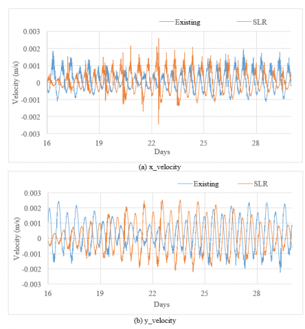
The comparison of current x-direction velocity under existing conditions and SLR conditions (a), as well as current y-direction velocity under both existing and SLR conditions (b) shown in Figure 5, visually illustrates the differences in hydrodynamic energy between the present and future scenarios. The observed increase in current velocity under the SLR scenario suggests that these changes in velocity could amplify erosion and significantly alter sediment transport across the bay.
Figure 5. Comparison between present and future conditions
3.3 Current velocities under existing and SLR conditions
Analyzing current velocities provides crucial insights into water movement patterns within Tambu Bay under both present-day and future SLR conditions. Under current conditions, maximum current velocities at observation points were 0.002 m/s for both longshore and cross-shore components. These low velocities stem from the bay's semi-enclosed nature, where restricted water exchange and significant seabed friction reduce flow speeds. This dynamic stabilizes sediment deposits, shapes hydrodynamic patterns, and highlights the bay’s sensitivity to external influences like sea level rise [32].
Simulations under a 1-meter SLR scenario showed a modest but significant increase in maximum velocities, reaching 0.0026 m/s for both components—a 30% increase. Average current velocities also rose from 0.01 m/s under existing conditions to 0.013 m/s in the SLR scenario. These increases, while relatively small in magnitude, indicate enhanced hydrodynamic energy within the bay due to higher water levels and a steeper hydraulic gradient [33].
Despite these changes in velocity, the overall direction of currents remained consistent with current conditions. This stability in circulation patterns suggests that the bay's hydrodynamic behavior, while more energetic under SLR, will retain its fundamental characteristics [34]. This consistency is essential for predicting sediment transport pathways and understanding long-term changes in depositional and erosional processes [35].
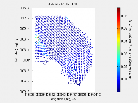
In Figure 6, we observe the spatial distribution of current velocity during the transition from ebb to flood tide under both existing (a) and SLR conditions (b). The intensified velocities under the SLR scenario (Figure 5(b)) suggest that the increase in water levels will lead to stronger tidal flows, which may alter sediment transport dynamics. These changes are particularly important for predicting erosion patterns and sediment deposition across the bay, which may further impact coastal stability.
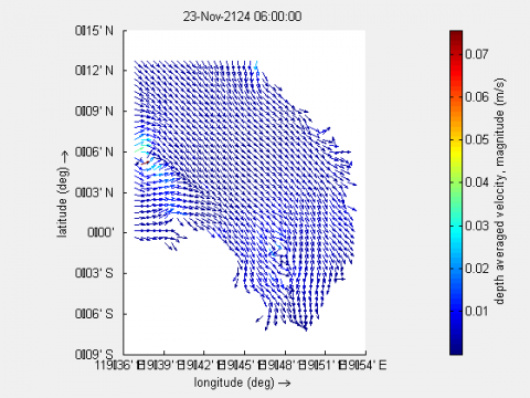
Similarly, Figure 7 presents the spatial distribution of current velocity during the transition from flood to ebb tide under existing (a) and SLR conditions (b). The enhanced velocities in the SLR scenario again emphasize the increase in hydrodynamic energy due to rising sea levels. This change in velocity distribution further supports the notion that higher water levels will influence sediment suspension, potentially accelerating coastal erosion in the long term.
(a) Existing (28/11/2023)
(b) SLR (23/11/2124)
Figure 6. Spatial visualization of current velocity during the transition from ebb to flood tide
(a) Existing (28/11/2023)
(b) SLR (23/11/2124)
Figure 7. Spatial visualization of current velocity during the transition from flood to ebb tide
3.4 Broader implications of hydrodynamic changes
The combined impacts of SLR on water levels, tidal range, and current velocities are expected to substantially reshape Tambu Bay's hydrodynamic landscape. One of the most significant outcomes is the increase in tidal prism, which enhances water exchange between the bay and the open ocean [36]. This increase has implications for both sediment dynamics and water quality [37].
Changes in sediment transport dynamics are among the most critical implications of altered hydrodynamics. Increased tidal amplitudes and flow velocities are likely to intensify sediment suspension and redistribution. Coastal zones with unstable sediments may experience accelerated erosion, while deposition rates may increase in low-energy areas [38]. Intertidal regions, which are highly sensitive to changes in tidal range and current velocities, may see shifts in species composition and habitat suitability [39].
From a coastal management perspective, these findings emphasize the urgency of integrating hydrodynamic modeling into planning efforts. The intensification of tidal forces and redistribution of sediment demand proactive measures to protect vulnerable ecosystems and infrastructure [40]. Adaptive strategies, such as the reinforcement of coastal defenses, restoration of natural barriers like mangroves, and stricter regulations on pollutant discharge, are essential for mitigating the risks posed by rising sea levels [41].
The findings reveal significant hydrodynamic changes under SLR conditions, with amplified tidal energy, altered sediment dynamics, and increased risks to coastal stability [34].
The findings reveal significant hydrodynamic changes under SLR conditions, with amplified tidal energy, altered sediment dynamics, and increased risks to coastal stability [34, 42]. These changes have profound ecological implications, particularly for local marine ecosystems and communities [43].
Ecological Impacts:
Recommendations for Future Research and Policy Implications:
By addressing the ecological and socio-economic impacts of SLR, policymakers can design comprehensive strategies to ensure the long-term resilience of both ecosystems and the communities that depend on them.
This study provides a localized analysis of the impacts of a 1-meter SLR scenario on the hydrodynamic processes of Tambu Bay, emphasizing key changes in tidal dynamics and sediment transport. The results indicate a 25% increase in tidal range, a 30% rise in current velocities, and a mean water level (MWL) rise of approximately 0.5 meters. This observed MWL rise represents a regional hydrodynamic response shaped by Tambu Bay’s unique bathymetry, semi-enclosed configuration, and tidal regime. These local factors moderate the impacts of global SLR projections, underscoring the importance of region-specific assessments for understanding and addressing climate change impacts.
The findings highlight the urgency of implementing integrated adaptation strategies tailored to the region’s distinct physical and socioeconomic conditions. Key strategies, including ecosystem management, mangrove restoration, and resilient coastal infrastructure, are critical to mitigating the combined risks of sea level rise and land subsidence. These measures play a vital role in preserving vulnerable ecosystems and enhancing the resilience of local communities.
Beyond Tambu Bay, this study offers valuable insights into the broader implications of sea level rise in tectonically active regions. By emphasizing the importance of localized hydrodynamic modeling, the research provides actionable guidance for policymakers to develop targeted strategies that align with regional needs and global climate adaptation objectives. Future research should further investigate the combined effects of SLR, land subsidence, and storm surges to enhance understanding of long-term risks and inform sustainable coastal management policies.
We would like to express our gratitude to the Tadulako University Research and Community Service Institute for their generous funding of this research through the Rector's Decree No. 2653/UN. 28/KU/2024. We also want to acknowledge the Geospatial Information Agency for their pivotal role in providing the tidal data through https://srgi.big.go.id/tides, which were a cornerstone of this research.
|
ξ |
Water surface elevation relative to the reference datum, m |
|
u |
Horizontal velocity component in the xx-direction, m/s |
|
v |
Horizontal velocity component in the yy-direction, m/s |
|
ω |
Vertical velocity relative to the surface, m/s |
|
Q |
Flow contribution per unit area due to inflows and outflows, m/s |
|
qin,qout |
Local water source and sink per unit volume, m/s |
|
P |
Non-local flow source due to precipitation, m/s |
|
E |
Non-local flow sink due to evaporation, m/s |
|
d |
Water depth, m |
|
f |
Coriolis parameter, s⁻¹ |
|
$v_\textit{V}$ |
Vertical eddy viscosity coefficient, m²/s |
|
ρ0 |
Seawater density, kg/m³) |
|
$\tau$ |
Shear stress at the bed or surface, Pa |
|
Gϵ,GηG |
Curvilinear grid scale factors in the horizontal ϵ and η directions |
|
Mϵ,Mη |
External momentum forces due to hydraulic structures or sources |
|
Fϵ,Fη |
Horizontal Reynolds stress imbalance |
|
Pϵ,Pη |
Pressure gradient |
|
U,V |
Depth-averaged velocities in the xx and yy directions, m/s |
|
σ |
Vertical coordinate in the sigma-coordinate system |
[1] Nicholls, R.J., Hanson, S.E., Lowe, J.A., Warrick, R.A., Lu, X., Long, A.J. (2014). Sea-level scenarios for evaluating coastal impacts. Wiley Interdisciplinary Reviews: Climate Change, 5(1): 129-150. https://doi.org/10.1002/wcc.253
[2] Brysse, K., Oreskes, N., O’reilly, J., Oppenheimer, M. (2013). Climate change prediction: Erring on the side of least drama?. Global Environmental Change, 23(1): 327-337. https://doi.org/10.1016/j.gloenvcha.2012.10.008
[3] Sierra-Correa, P.C., Kintz, J.R.C. (2015). Ecosystem-based adaptation for improving coastal planning for sea-level rise: A systematic review for mangrove coasts. Marine Policy, 51: 385-393. https://doi.org/10.1016/j.marpol.2014.09.013
[4] Hernández-Delgado, E.A. (2015). The emerging threats of climate change on tropical coastal ecosystem services, public health, local economies and livelihood sustainability of small islands: Cumulative impacts and synergies. Marine Pollution Bulletin, 101(1): 5-28. https://doi.org/10.1016/j.marpolbul.2015.09.018
[5] Lloyd, M.G., Peel, D., Duck, R.W. (2013). Towards a social–ecological resilience framework for coastal planning. Land Use Policy, 30(1): 925-933. https://doi.org/10.1016/j.landusepol.2012.06.012
[6] Intergovernmental Panel On Climate Change. (2014). Sea Level Change,” in Climate Change 2013 – The Physical Science Basis, 1st ed., Cambridge University Press, pp. 1137-1216. https://doi.org/10.1017/CBO9781107415324.026
[7] Elliott, M., Cutts, N.D., Trono, A. (2014). A typology of marine and estuarine hazards and risks as vectors of change: A review for vulnerable coasts and their management. Ocean & Coastal Management, 93: 88-99. https://doi.org/10.1016/j.ocecoaman.2014.03.014
[8] Abdullah, A.I. (2020). A field survey for the rupture continuity of Palu-Koro fault after Donggala earthquake on September 28th, 2018. Journal of Physics: Conference Series, 1434(1): 012009. https://doi.org/10.1088/1742-6596/1434/1/012009
[9] Ceccarelli, D.M., Lestari, A.P., White, A.T. (2022). Emerging marine protected areas of eastern Indonesia: Coral reef trends and priorities for management. Marine Policy, 141: 105091. https://doi.org/10.1016/j.marpol.2022.105091
[10] Kitheka, J.U., Obiero, M., Nthenge, P. (2005). River discharge, sediment transport and exchange in the Tana Estuary, Kenya. Estuarine, Coastal and Shelf Science, 63(3): 455-468. https://doi.org/10.1016/j.ecss.2004.11.011
[11] Pickering, M.D., Horsburgh, K.J., Blundell, J.R., Hirschi, J.M., Nicholls, R.J., Verlaan, M., Wells, N.C. (2017). The impact of future sea-level rise on the global tides. Continental Shelf Research, 142: 50-68. https://doi.org/10.1016/j.csr.2017.02.004
[12] Nugroho, A., Magdalena, I. (2020). Hydrodynamic model for investigating the impact of reclamation islands in Jakarta Bay to mangrove ecosystem in the area. AIP Conference Proceedings, 2268(1): 050003. https://doi.org/10.1063/5.0016899
[13] Greenberg, D.A., Blanchard, W., Smith, B., Barrow, E. (2012). Climate change, mean sea level and high tides in the Bay of Fundy. Atmosphere-Ocean, 50(3): 261-276. https://doi.org/10.1080/07055900.2012.668670
[14] Singer, M.N., Cavalcante, G.H., Atabay, S. (2023). Hydrodynamic modeling of Sharjah lagoons under climate changes, United Arab Emirates (UAE). Regional Studies in Marine Science, 63: 102995. https://doi.org/10.1016/j.rsma.2023.102995
[15] Bigalbal, A., Rezaie, A.M., Garzon, J.L., Ferreira, C.M. (2018). Potential impacts of sea level rise and coarse scale marsh migration on storm surge hydrodynamics and waves on coastal protected areas in the Chesapeake Bay. Journal of Marine Science and Engineering, 6(3): 86. https://doi.org/10.3390/jmse6030086
[16] Wang, P., Linker, L., Wang, H., Bhatt, G., Yactayo, G., Hinson, K., Tian, R. (2017). Assessing water quality of the Chesapeake Bay by the impact of sea level rise and warming. IOP Conference Series: Earth and Environmental Science, 82(1): 012001. https://doi.org/10.1088/1755-1315/82/1/012001
[17] Lesser, G.R., Roelvink, J.V., van Kester, J.T.M., Stelling, G.S. (2004). Development and validation of a three-dimensional morphological model. Coastal Engineering, 51(8-9): 883-915. https://doi.org/10.1016/j.coastaleng.2004.07.014
[18] De Goede, E.D. (2020). Historical overview of 2D and 3D hydrodynamic modelling of shallow water flows in the Netherlands. Ocean Dynamics, 70(4): 521-539. https://doi.org/10.1007/s10236-019-01336-5
[19] Williams, J.J., Esteves, L.S. (2017). Guidance on setup, calibration, and validation of hydrodynamic, wave, and sediment models for shelf seas and estuaries. Advances in Civil Engineering, 2017(1): 5251902. https://doi.org/10.1155/2017/5251902
[20] Haigh, I.D., Pickering, M.D., Green, J.M., Arbic, B.K., Arns, A., Dangendorf, S., Hill, D.F., Horsburgh, K., Howard, T., Idier, D., Jay, D.A., Jänicke, L., Lee, S.B., Müller, M., Schindelegger, M., Talke, S.A., Wilmes, S.B., Woodworth, P.L. (2020). The tides they are a-Changin': A comprehensive review of past and future nonastronomical changes in tides, their driving mechanisms, and future implications. Reviews of Geophysics, 58(1): e2018RG000636. https://doi.org/10.1029/2018RG000636
[21] Bertin, X., Oliveira, A., Fortunato, A.B. (2009). Simulating morphodynamics with unstructured grids: Description and validation of a modeling system for coastal applications. Ocean Modelling, 28(1-3): 75-87. https://doi.org/10.1016/j.ocemod.2008.11.001
[22] Carrasco, A.R., Plomaritis, T., Reyns, J., Ferreira, Ó., Roelvink, D. (2018). Tide circulation patterns in a coastal lagoon under sea-level rise. Ocean Dynamics, 68: 1121-1139. https://doi.org/10.1007/s10236-018-1178-0
[23] Swapna, P., Ravichandran, M., Nidheesh, G., Jyoti, J., Sandeep, N., Deepa, J.S., Unnikrishnan, A.S. (2020). Sea-level rise. In Assessment of Climate Change over the Indian Region: A Report of the Ministry of Earth Sciences (MoES), Government of India, Singapore, pp. 175-189. https://doi.org/10.1007/978-981-15-4327-2_9
[24] Magar, V. (2022). Sediment transport and morphodynamic modelling for coasts and shallow environments. Oceanography. https://doi.org/10.1002/essoar.10501308.1
[25] Zhong, M., Xiao, L., Li, X., Mei, Y., Jiang, T., Song, L., Chen, X. (2024). A study on compound flood prediction and inundation simulation under future scenarios in a coastal city. Journal of Hydrology, 628: 130475. https://doi.org/10.1016/j.jhydrol.2023.130475
[26] Robertson, R. (2011). Interactions between tides and other frequencies in the Indonesian seas. Ocean Dynamics, 61(1): 69-88. https://doi.org/10.1007/s10236-010-0343-x
[27] Nogueira, J., Evangelista, H., Bouchaou, L., Moreira, L., Sifeddine, A., ElMouden, A., Msanda, F., Caquineau, S., Briceño-Zuluaga, F.J., Licínio, M.V., Mandeng-Yogo, M., Mendez-Millan, M., Cordeiro, R.C., Knoppers, B., Moreira-Ramírez, M., Martins, R. (2022). Coastal wetland responses to a century of climate change in northern Sahara, Morocco. Limnology and Oceanography, 67(2): 285-299. https://doi.org/10.1002/lno.11992
[28] Ozkan, C., Perez, K., Mayo, T. (2020). The impacts of wave energy conversion on coastal morphodynamics. Science of the Total Environment, 712: 136424. https://doi.org/10.1016/j.scitotenv.2019.136424
[29] Nazarnia, H., Nazarnia, M., Sarmasti, H., Wills, W.O. (2020). A systematic review of civil and environmental infrastructures for coastal adaptation to sea level rise. Civil Engineering Journal, 6(7): 1375-1399. https://doi.org/10.28991/cej-2020-03091555
[30] Guo, L., Brand, M., Sanders, B.F., Foufoula-Georgiou, E., Stein, E.D. (2018). Tidal asymmetry and residual sediment transport in a short tidal basin under sea level rise. Advances in Water Resources, 121: 1-8. https://doi.org/10.1016/j.advwatres.2018.07.012
[31] Khojasteh, D., Lewis, M., Tavakoli, S., Farzadkhoo, M., Felder, S., Iglesias, G., Glamore, W. (2022). Sea level rise will change estuarine tidal energy: A review. Renewable and Sustainable Energy Reviews, 156: 111855. https://doi.org/10.1016/j.rser.2021.111855
[32] Yu, Q., Wang, Y., Shi, B., Wang, Y.P., Gao, S. (2017). Physical and sedimentary processes on the tidal flat of central Jiangsu Coast, China: Headland induced tidal eddies and benthic fluid mud layers. Continental Shelf Research, 133: 26-36. https://doi.org/10.1016/j.csr.2016.12.015
[33] Passeri, D.L., Hagen, S.C., Medeiros, S.C., Bilskie, M.V., Alizad, K., Wang, D. (2015). The dynamic effects of sea level rise on low-gradient coastal landscapes: A review. Earth's Future, 3(6): 159-181. https://doi.org/10.1002/2015EF000298
[34] Liang, H., Kuang, C., Olabarrieta, M., Gu, J., Song, H., Dong, Z. (2020). Coastal morphodynamic responses of a mixed-energy and fine-sediment coast to different sea level rise trends. Coastal Engineering, 161: 103767. https://doi.org/10.1016/j.coastaleng.2020.103767
[35] Pearson, S.G., van Prooijen, B.C., Elias, E.P., Vitousek, S., Wang, Z.B. (2020). Sediment connectivity: A framework for analyzing coastal sediment transport pathways. Journal of Geophysical Research: Earth Surface, 125(10): e2020JF005595. https://doi.org/10.1029/2020JF005595
[36] Sun, J., Peng, L., Zhu, X., Li, Z., Shi, H., Zhan, C., You, Z. (2024). The effects of changes in the coastline and water depth on tidal prism and water exchange of the Laizhou Bay, China. Frontiers in Marine Science, 11: 1459482. https://doi.org/10.3389/fmars.2024.1459482
[37] Zeng, W., Beck, M.B. (2003). STAND, a dynamic model for sediment transport and water quality. Journal of Hydrology, 277(1-2): 125-133. https://doi.org/10.1016/S0022-1694(03)00073-8
[38] Kim, D., Jo, J., Kim, B., Ryu, J., Choi, K. (2020). Influence of dike-induced morphologic and sedimentologic changes on the benthic ecosystem in the sheltered tidal flats, Saemangeum area, west coast of Korea. Environmental Pollution, 257: 113507. https://doi.org/10.1016/j.envpol.2019.113507
[39] Baker, A.L., Craighead, R.M., Jarvis, E.J., Stenton, H.C., Angeloudis, A., Mackie, L., Avdis, A., Piggott, M.D., Hill, J. (2020). Modelling the impact of tidal range energy on species communities. Ocean & Coastal Management, 193: 105221. https://doi.org/10.1016/j.ocecoaman.2020.105221
[40] Alves, B., Angnuureng, D.B., Morand, P., Almar, R. (2020). A review on coastal erosion and flooding risks and best management practices in West Africa: What has been done and should be done. Journal of Coastal Conservation, 24(3): 38. https://doi.org/10.1007/s11852-020-00755-7
[41] Rodrigues, J.N., Bhattacharya, S., Sachdev, B.K., Cabete, D. (2024). Disaster management in the Sundarbans delta ecosystem through environmental governance and sustainable planning. Revista de Direito Econômico e Socioambiental, 15(2): e268-e268. https://doi.org/10.7213/revdireconsoc.v15i2.31364
[42] Palmer, K., Watson, C., Fischer, A. (2019). Non-linear interactions between sea-level rise, tides, and geomorphic change in the Tamar Estuary, Australia. Estuarine, Coastal and Shelf Science, 225: 106247. https://doi.org/10.1016/j.ecss.2019.106247
[43] Jennings, S., Brander, K. (2010). Predicting the effects of climate change on marine communities and the consequences for fisheries. Journal of Marine Systems, 79(3-4): 418-426. https://doi.org/10.1016/j.jmarsys.2008.12.016
[44] Owens, P.N. (2020). Soil erosion and sediment dynamics in the Anthropocene: A review of human impacts during a period of rapid global environmental change. Journal of Soils and Sediments, 20: 4115-4143. https://doi.org/10.1007/s11368-020-02815-9
[45] Hopkinson, C.S., Wolanski, E., Cahoon, D.R., Perillo, G.M., Brinson, M.M. (2019). Coastal wetlands: A synthesis. In Coastal Wetlands, pp. 1-75. https://doi.org/10.1016/B978-0-444-63893-9.00001-0