Duman Shaimerdenov*![]() | Alma Zakirova
| Alma Zakirova![]() | Zhanar Akhayeva
| Zhanar Akhayeva![]() | Anara Karymsakova
| Anara Karymsakova![]() | Rozamgul Niyazova
| Rozamgul Niyazova![]()
© 2023 IIETA. This article is published by IIETA and is licensed under the CC BY 4.0 license (http://creativecommons.org/licenses/by/4.0/).
OPEN ACCESS
Kazakhstan has been facing a significant reduction in its renewable freshwater resources due to various anthropogenic factors (climate change, agricultural practices, industrialization, urbanization). The reduction of renewable freshwater has led to water scarcity, desertification, health impacts, economic impacts. The relevance of the subject matter is determined by the importance of remote sensing of water bodies of the Republic of Kazakhstan using modern methods of satellite biometrics to form objective ideas about the real state of the country's water resources. The purpose of this paper is to study the currently existing effective methods for recognising the physical characteristics of water bodies of the Republic of Kazakhstan using remote sensing. The methodology of this research work is based on a combination of methods of system analysis of the possibilities of remote sensing of water bodies using satellite bathymetry with an analytical study of methods for recognising the physical characteristics of water bodies of the Republic of Kazakhstan by remote sensing. The results obtained during this research indicate the high accuracy of the remote sensing method using satellite bathymetry and the feasibility of its practical application in the future for the successful solution of similar problems.
water resources, satellite bathymetry, earth remote sensing technology, monitoring of the state of water bodies
The water resources of Central Asia in general and Kazakhstan in particular play and will play an important role in the life of human communities. At the same time, in the last few decades, the negative impact of the anthropogenic factor on the state of Kazakhstan's water resources has led to a decrease in the volume of renewable freshwater, which is a significant threat to the country's water bodies from the point of view of their conservation prospects [1]. The current situation encourages the search for effective methods of monitoring water bodies of the Republic of Kazakhstan to develop effective measures for their conservation.
Initial attempts to automatically estimate the depth of water were based on a combination of technologies for obtaining aerial photographs using multispectral data and radiometric methods. With the advent of Landsat images, the main methods of monitoring the seabed became enlarged and improved, which could be effectively applied to obtain optical satellite images. In subsequent years, the development of Earth remote sensing technologies has significantly expanded the practical application of these methodologies to obtain data with improved spatial and spectral resolution characteristics [2-4]. The main obstacles to the successful practical implementation of these technologies were the reflection of light when penetrating the depth and turbidity of water. However, bathymetric approaches using satellite imagery data are considered as a quick and cost-effective solution for automatic sensing of water space, as well as for calculating the depth in shallow water.
Subsequently, a wide variety of empirical models and methods for the formation of bathymetric estimates were proposed by establishing a statistical relationship between the pixel values of the image and the measured field of the water depth value. In particular, an algorithm using the reflection coefficient was developed and presented, and its advantages for extracting depth even in deep water (>25 m) were demonstrated, in contrast to the standard linear transformation algorithm. Moreover, a modified version of the Lizenga model was proposed by Conger et al. in 2006, assuming the use of data of a single-colour strip and LIDAR bathymetry instead of two colour strips during rotation [5].
Using images with a high spatial resolution (~2 m), such as QuickBird and WorldView-2, can give high accuracy and a more detailed bathymetric map, however, these images are extremely expensive and can cover a smaller area. In contrast, medium spatial resolution images such as Landsat (30 m) have been available for free since 1985 and can be used to create reliable and updated medium resolution bathymetric maps. This capability was further improved after the launch of Landsat-8 in February 2013 [6]. However, after the launch of the Sentinel-2A satellite in June 2015 with a spatial resolution of 10 m, the ability to obtain a more detailed and accurate bathymetric map is expected to improve, where Sentinel-2A includes the necessary spectral bands to determine depth parameters.
To test this assumption, in the course of this scientific study, an attempt was made to obtain a qualitative assessment of the ability of Sentinel-2A images to estimate depth parameters in coastal waters. In this regard, the Manaka dam and the mouth of the Nura River were chosen as the research area near the village of G. Mustafin (located in the Karaganda region of the Republic of Kazakhstan), where there is an accurate and reliable database of depth values for this region. This can make it possible to qualitatively calibrate various methods for estimating depth values, as well as to evaluate their accuracy [7]. At the first stage, traditional methods of linear and coefficient transformations were applied to two selected Sentinel-2A images to obtain depth values in each pixel by considering all possible combinations of bands and band ratios (band 2: blue (458-523 Nm), band 3: Green (543-578 Nm) and band 4: Red (650-680 Nm), spatial resolution: 10 m).
The research questions raised in this study are centered around the recognition of physical characteristics of water bodies of the Republic of Kazakhstan using remote sensing technologies. The study discusses the necessity around these questions as it is essential to monitor the physical characteristics of water bodies for their effective management and sustainable use. Therefore, the study highlights the significance of studying the methods for recognizing the physical characteristics of water bodies using modern satellite technology to better understand the current state of water resources and plan for their management.
System analysis was used to study the possibilities of remote sensing of water bodies using satellite bathymetry. This involved the systematic study of available publications of domestic and foreign researchers on the practical use of remote sensing technologies using Sentinel-2A artificial satellites. Analytical method was used to recognize the physical characteristics of water bodies of the Republic of Kazakhstan by remote sensing, involving the practical application of satellite bathymetry in research. This involved the analysis of the practical use of satellite bathymetry in remote sensing operations and the comparison of the preliminary results obtained during the study with the results of other researchers of various aspects of remote sensing of water bodies. The research involved practical application of satellite bathymetry to obtain high-quality photographs of the studied surfaces and form objective conclusions based on the information received. The water area of the Manaka dam and the mouth of the Nura River was chosen as the areas of scientific research near the village of Gabiden Mustafin in the Bukhar-Zhyrau district of the Karaganda region of the Republic of Kazakhstan.
The theoretical basis of this research work was made up of developments in the field of the practical application of Sentinel-2A satellites for remote sensing operations to obtain high-quality photographs of the studied surfaces and form objective conclusions based on the information received. During the preparation of the theoretical basis of this scientific research, a significant amount of data was taken from the scientific developments of foreign researchers submitted for consideration.
The current research status of remote sensing recognition technology for physical characteristics of water bodies worldwide is relatively advanced, and there is a growing interest in this field of study. The practical application of remote sensing technology has been demonstrated to be a useful tool for recognizing the physical characteristics of water bodies. Researchers have used various remote sensing platforms, such as satellites, to study water bodies, including lakes, rivers, and reservoirs [8-10].
Many researchers have focused on the use of satellite bathymetry, which involves using satellite remote sensing data to estimate the depth of water bodies [11, 12]. This technology has been applied to several regions worldwide, including North America, Europe, and Asia, to study water bodies' physical characteristics. There have also been several studies on the use of remote sensing technology to identify and monitor harmful algal blooms, which can have significant impacts on water quality and aquatic ecosystems [13-15]. Researchers have used various remote sensing platforms, such as drones, to study algal blooms in water bodies [16]. In recent years, advances in remote sensing technology have led to the development of new tools and techniques, such as machine learning and artificial intelligence, to improve the accuracy of remote sensing data analysis for water bodies [17-19]. These developments have led to more comprehensive and detailed studies of water bodies' physical characteristics, such as water temperature, water quality, and water depth [20].
The bathymetry assessment based on satellite observations includes the extraction of bottom radiation from the measured water reflection coefficient. The reflection coefficient R is defined as the ratio of the water surface radiation to the descending stream radiation directly above the water surface. This feature describes the absorption of light, the associated optical properties of the surface, as well as the scattering properties of the components in the water, as well as the albedo of the bottom and depth [8]. In the process of obtaining bathymetry using satellite observations, the fundamental physical principle is based on the phenomena of light extinction in a water column, as well as bottom reflection and dispersion. Installed on artificial Earth satellites optical sensors register the radiation power of the Earth's surface and the Earth's atmosphere illuminated by sunlight. At the same time, the sensor registers only part of the reflected radiation, usually about 80% at a wavelength of 0.85 microns, and about 50% at a wavelength of 0.45 microns. Losses are primarily associated with two processes occurring in the Earth's atmosphere - absorption and scattering [11, 21].
The main sources of absorption are atmospheric gases, mainly O3, H2O, O2, CO2, CH4 and N2O, however, it is worth noting that the spectral ranges of channels used on spacecraft sensors are selected in such a way as to register radiation in the so-called transparency windows, and absorption by atmospheric gases in this case is not a critical factor.
During atmospheric scattering, part of the incoming Solar flux changes its direction as a result of interaction with non-absorbing aerosols (it is reflected in the direction of the sensor registering radiation), the remaining part of the flux passes through the atmosphere, reaches the Earth's surface and is reflected from it [12]. At the same time, part of the radiation reflected from the Earth's surface is also scattered by the atmosphere, and part is reflected from it in the direction of the Earth, and then reflected again from the Earth's surface (backscattering effect). Table1 shows the main technical data of the Sentinel-2A satellite and its target equipment used in scientific research.
Table 1. Brief description of the Sentinel-2A satellite and its target equipment
|
Band Number |
Band Name |
Central Wavelength (nm) |
Bandwidth (nm) |
|
1 |
Coastal aerosol |
444.9 |
27 |
|
2 |
Blue |
496.6 |
98 |
|
3 |
Green |
560.0 |
45 |
|
4 |
Red |
664.5 |
38 |
|
5 |
Red Edge 1 |
703.9 |
19 |
|
6 |
Red Edge 2 |
740.2 |
18 |
|
7 |
Red Edge 3 |
728.5 |
28 |
|
8 |
NIR |
835.1 |
145 |
|
8A |
Narrow NIR |
864.8 |
33 |
|
9 |
Water vapour |
945.0 |
26 |
|
10 |
SWIR* Cirrus |
1373.5 |
75 |
|
11 |
SWIR 1 |
1613.7 |
143 |
|
12 |
SWIR 2 |
2202.4 |
242 |
Four cloudless images of the studied area of the Manaka Dam were selected. The images of this area were obtained on July 1 and October 9, 2019, September 13 and November 7, 2020. Four cloudless images of the studied area of the Nura River mouth were selected. The images of this area were obtained on September 19 and October 4, 2019, August 7 and September 13, 2020. During the registration and digitization of radiation, the continuous signal is quantized and stored as dimensionless integer values (DN) recorded in pixel values forming the image obtained by the scanner. To translate dimensionless integer values, as a rule, a linear transformation of the following form is used:
$L s a t=D N \times G A I N+B I A S$ (1)
where, Lsat is the radiation power recorded by the sensor; GAIN is the multiplier; BIAS is the magnitude of the shift.
To study the reflectivity, the formula is used:
$P=\frac{\pi L s a t}{E 0 \cos Q z}$ (2)
where, E0 is the extra-atmospheric solar constant; Qz is the Solar zenith angle.
It should be taken into account that E0=ESUN/d, where ESUN is the coefficient of solar extra-atmospheric spectral radiation determined for each spectral channel, and d is the distance from the Sun to the Earth in astronomical units at the time of the survey. The reflectivity values obtained by formula 2 do not take into account the influence of the atmosphere, that is, they are the reflectivity at the upper edge of the atmosphere (TOA reflectance).
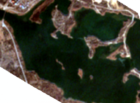
Figure 1. Satellite image of the Nura River Mouth
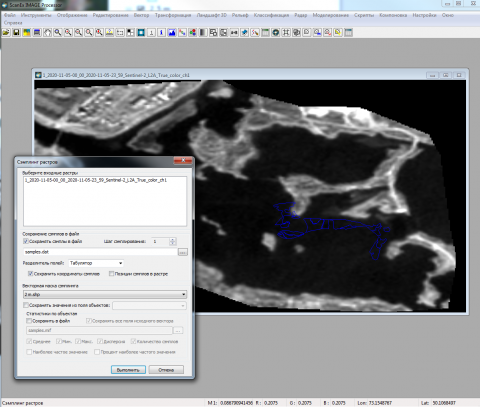
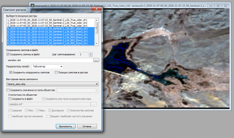
To account for the influence of the atmosphere, you can use a parametric model of atmospheric correction implemented based on the 6S method, or a simplified model of atmospheric correction DOS (dark object subtraction), without taking into account the factor of absorption of radiation by aerosols. Satellite bathymetry was used to obtain images of the Nura River mouth and the water basin near the Manaka Dam (Figures 1-4).
Figure 2. Depth data in the Nura River mouth area
Using computer modelling methods, images with depth data were linked to satellite images based on reference points.
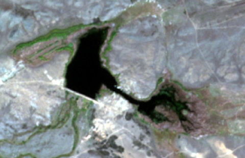
Figure 3. Satellite image of the Manaka Dam water basin
This was done to obtain the most reliable information necessary for a qualitative analysis of the real state of the investigated water body.
Figure 4. Depth data in the Manaka Dam water basin area
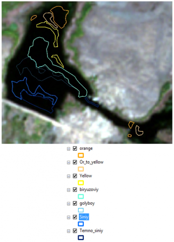
Vector colour files for the Manaka Dam from less to deeper are shown in Figure 5.
Figure 5. Vector colour files for the Manaka Dam as the depth increases
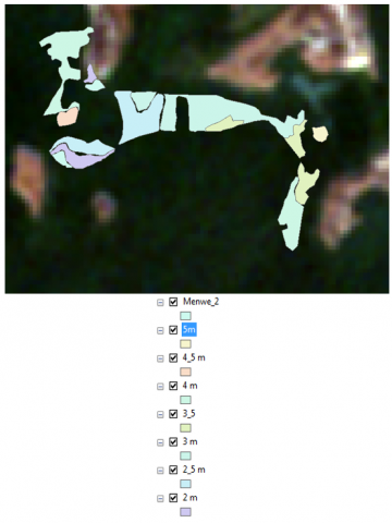
The shapes of the depth values in the area of the Nura River mouth from the linked picture are shown in Figure 6.
Figure 6. Shapes by depth values in the area of the Nura River mouth from the linked image
Using the ScanEx Image Processor v.4.2 app, which allows obtaining the values of each pixel of each channel separately, the values are extracted of the depths of the Nura River mouth, limited by vector data (Figure 7).
Figure 7. Depths of the Nura River mouth, limited by vector data
This technique allows us to obtain high accuracy of the desired values, which is extremely important for the formation of a qualitative analysis of indicators used in assessing the real state of a water body by satellite bathymetry methods. A similar procedure is carried out at depths in the Manaka dam water area (Figure 8).
Figure 8. Depths of the Manaka dam water area, limited by vector data
The accuracy of the data obtained using these techniques is of fundamental importance in this context, which determines the broad prospects for their further practical application when conducting similar studies in the future. The recognition of the physical characteristics of water bodies of the Republic of Kazakhstan by remote sensing makes it possible to effectively establish their main characteristics that are important from the point of view of the prospects for using these objects for the needs of the national economy of the country (Figure 9).
Figure 9. Graphical dependence of pixels of each channel, bounded by deep boundaries, satellite images of the Nura River mouth and the Manaka dam area
Remote sensing using satellite bathymetry methods allows for high accuracy of depth map measurements in the studied areas, as well as obtaining a high-quality panorama of the coastline of water bodies, taking into account the terrain in this area, as well as other characteristic features. The high accuracy of the data obtained using Sentinel-2A satellites makes it possible to conclude that the subsequent use of satellite bathymetry techniques for conducting similar studies aimed at obtaining reliable information on the real state of water bodies is of great strategic importance. Comparison of research data obtained using a combination of methods is necessary for maximum reliability of the research picture and the formation of conclusions based on them, reflecting the main results obtained. In general, the use of high-resolution satellite images makes it possible to conduct studies of water bodies of almost any geographical distance and obtain high-precision results achieved through the use of high-tech equipment and modern computer programs for data processing. The quality of software processing of the obtained results is also essential for achieving high accuracy of the research, regardless of the volume of information processed and the complexity of its processing operations.
The practical application of remote sensing methods of water bodies using satellite bathymetry allows us to obtain an objective picture of the current state of the state's water bodies, as well as to identify possible problems of water use that require timely and qualitative solutions [22]. Such studies can qualitatively solve the problem of obtaining objective, reliable and accurate data describing the current state of water bodies of strategic importance in the context of the prospects for their use in agriculture, as well as in any other branch of the state economy. The development of effective methods of remote sensing of water bodies using satellite technology is one of the priorities of modern developers of satellite tracking systems for the state of natural resources of any state [23].
Modern concepts of monitoring ecosystems, including water bodies of Central and Central Asia, suggest the possibility of using remote sensing methods of the most important from an ecological point of view surface areas, with the identification of their characteristic features and current problems that require early resolution to normalise the overall environmental situation. To this end, scientific developments of modern satellite monitoring systems are being carried out in some states that allow for high-quality remote sensing of water, forest and some other objects, highlighting their characteristic features and parameters that are of fundamental importance from the point of view of subsequent use for the needs of the national economy [24-26]. Concerning the methods of remote sensing of water bodies, it should be noted that they allow you to determine the depth of reservoirs in different areas, the characteristic features of the relief of the coastline, as well as the distinctive features of the landscape of adjacent areas in the dynamics of their changes. The data obtained from remote sensing with the use of satellite technology make it possible to adjust the policy in the field of the use of water resources of the state promptly, which in the future will lead to an overall improvement in water use conditions and changes for the better in the ecological situation in the studied regions.
When conducting a comparative assessment of the characteristic features of providing water resources to the regions of Central and Central Asia, it should be taken into account that the basins of the main rivers of these regions – the Syr Darya and the Amu Darya are the main ones in terms of aquiferous properties and the state of the entire ecosystem of these regions largely depends on their current state [27]. Monitoring of the state of river basins by remote sensing methods makes it possible to qualitatively monitor the dynamics of changes in the state of water basins, and also provides grounds for timely decision-making on all controversial issues related to the implementation of measures to improve the environmental situation in the region. The development, testing and implementation of remote sensing techniques make it possible to determine with the maximum degree of reliability such characteristics of water bodies as the degree of contamination with industrial waste, the ratio of depths in various sections of water bodies, as well as the boundaries of water bodies where there is a potential danger in terms of the likelihood of industrial and household waste discharges. In addition, timely remote sensing makes it possible to qualitatively assess the prospects for drying out of water bodies, predict the loss of water volumes, and also contributes to the timely adoption of necessary measures to counteract these phenomena [28].
Modern optical sensing systems make it possible to obtain a high-quality panoramic survey of the terrain in a given unit of time and are subject to relatively low material costs [29]. At the same time, there are significant advantages of the radar method of optical sensing, mainly in situations where unfavourable atmospheric conditions occur, significantly complicating data collection and processing [30]. These include high cloud cover and smoke content of the studied area, as well as work in conditions of increased emissions of harmful substances into the atmosphere [31].
The results of this scientific study are of significant importance from the point of view of the possibility of forming a qualitative assessment of the real state of water resources of the Republic of Kazakhstan and are also of great importance for employees of environmental organizations of the Republic of Kazakhstan, who, by the nature of their professional activities, face the need to form a qualitative assessment of the real physical characteristics of water bodies protected following the norms of the current legislation of the country.
In general, remote sensing methods using Sentinel-2A satellites have shown high accuracy in determining the main parameters of the studied water bodies of the Republic of Kazakhstan, which suggests the possibility of their subsequent use for monitoring the country's water bodies. The use of satellite bathymetry for remote sensing of the studied water bodies makes it possible to obtain high-resolution photographic images, the sequential processing of which makes it possible to compile a complete and objective picture of the study of the current state of water bodies. The patterns identified in the process of remote sensing should be taken into account in the future when conducting scientific studies of the current state of water bodies using Sentinel-2A satellites, which will allow us to get the most complete and objective idea of the nature of changes in the state of water bodies and correctly predict the main trends of such changes affecting the ecological situation of the entire geographical region as a whole.
[1] Rani, M., Seenipandi, K., Rehman, S., Kumar, P., Sajjad, H. (2020). Remote sensing of ocean and coastal environments. Elsevier, Oxford.
[2] Mishra, D., Ogashawara, I., Giteson, A. (2017). Bio-optical modelling and remote sensing of inland waters. Elsevier, Oxford.
[3] Batrakov, D.O., Antyufeyeva, M.S., Antyufeyev, A.V., Batrakova, A.G. (2016). Inverse problems and UWB signals in biomedical engineering and remote sensing. 2016 8th International Conference on Ultrawideband and Ultrashort Impulse Signals, UWBUSIS 2016, pp. 148-151. https://doi.org/10.1109/UWBUSIS.2016.7724174
[4] Batrakov, D.O., Antyufeyeva, M.S., Antyufeyev, A.V., Batrakova, A.G. (2017). Remote sensing of plane-layered media with losses using UWB signals. In 2017 11th International Conference on Antenna Theory and Techniques, ICATT 2017, pp. 370-373. https://doi.org/10.1109/ICATT.2017.7972666
[5] Pandey, P.C., Srivastava, P., Balzter, H., Bhattacharya, B. (2020). Hyperspectral remote sensing. Elsevier, Oxford.
[6] Baghdadi, N., Zribi, M. (2016). Microwave remote sensing of land surfaces. ISTE Press – Elsevier, Oxford.
[7] Srivastava, P., Gupta, M., Tsakiris, G., Quinn, N. (2020). Agricultural water management. Academic Press, London.
[8] Toming, K., Kutser, T., Tuvikene, L., Viik, M., Noges, T. (2016). Dissolved organic carbon and its potential predictors in eutrophic lakes. Water Research, 102: 32-40. https://doi.org/10.1016/j.watres.2016.06.012
[9] Dzhetimov, M.A., Tokpanov, Y.A., Andasbayev, Y.S., Yesengabylov, I.Z. (2014). Assessment of pollution influence of bottom sediments on quality of water of the Ili river. Life Science Journal, 11(3): 335-338. http://www.lifesciencesite.com/lsj/life1103/048_23185life110314_335_338.pdf
[10] Korneychuk, N.N., Kirichuk, G.Y. (2018). Structural and functional organization of phytomicroperiphyton of the transboundary stviga river. Hydrobiological Journal, 54(1): 3-18. https://doi.org/10.1615/hydrobj.v54.i1.10
[11] Sun, D., Huan, Y., Wang, S., Qiu, Z., Ling, Z., Mao, Z., He, Y. (2019). Remote sensing of spatial and temporal patterns of phytoplankton assemblages in the Bohai Sea, Yellow Sea, and East China Sea. Water Research, 157: 119-133. https://doi.org/10.1016/j.watres.2019.03.081
[12] He, J., Chen, Y., Wu, J., Stow, D.A., Christakos, G. (2020). Space-time chlorophyll-a retrieval in optically complex waters that accounts for remote sensing and modelling uncertainties and improves remote estimation accuracy. Water Research, 171: 115403. https://doi.org/10.1016/j.watres.2019.115403
[13] Borisova, E.A. (2012). Features of the water crisis in Central Asia. History and Modernity, 1: 138-146. https://cyberleninka.ru/article/n/osobennosti-vodnogo-krizisa-v-tsentralnoy-azii.
[14] Ryskaliyeva, A.K., Baltabayev, M.E., Abaeva, K.T. (2019). Empirical method for predicting the enthalpy changes of combustion of amides. Journal of the Serbian Chemical Society, 84(5): 477-481. https://doi.org/10.2298/JSC180809094R
[15] Ismayilov, G.K., Proshlyakov, I.V. (2020). Problems of water supply in the Central Asian republics. Nature Management, 1: 64-73.
[16] Liang, S., Li, X., Wang, J. (2018). Advanced remote sensing. Academic Press, London.
[17] Baghdadi, N., Zribi, M. (2016). Land surface remote sensing in continental hydrology. ISTE Press – Elsevier, Oxford.
[18] Kolesnikova, O., Syrlybekkyzy, S., Fediuk, R., Yerzhanov, A., Nadirov, R., Utelbayeva, A., Agabekova, A., Latypova, M., Chepelyan, L., Volokitina, I., Vatin, N.I., Kolesnikov, A., Amran, M. (2022). Thermodynamic simulation of environmental and population protection by utilization of technogenic tailings of enrichment. Materials, 15(19): 6980. https://doi.org/10.3390/ma15196980
[19] Fialko, N.M., Navrodska, R.O., Shevchuk, S.I., Gnedash, G.O. (2020). The environmental reliability of gas-fired boiler units by app lying modern heat-recovery technologies. Naukovyi Visnyk Natsionalnoho Hirnychoho Universytetu, 2020(2): 96-100. https://doi.org/10.33271/nvngu/2020-2/096
[20] Wang, M., Shi, W., Watanabe, S. (2020). Satellite-measured water properties in high altitude Lake Tahoe. Water Research, 178: 115839. https://doi.org/10.1016/j.watres.2020.115839
[21] Gazaliyev, A.M., Portnov, V.S., Kamarov, R.K., Maussymbayeva, A.D., Yurov, V.M. (2015). Geophysical research of areas with increased gas content of coal seams. Naukovyi Visnyk Natsionalnoho Hirnychoho Universytetu, (6): 24-29. http://nvngu.in.ua/index.php/en/archive/on-the-issues/1171-2015/contents-no-6-2015/geology/3222-geophysical-research-of-areas-with-increased-gas-content-of-coal-seams.
[22] Zhang, T., Li, J., Pu, J., Wu, F. (2021). Physical and chemical control on CO2 gas transfer velocities from a low-gradient subtropical stream. Water Research, 204: 117564. https://doi.org/10.1016/j.watres.2021.117564
[23] Baracchini, T., Wuest, A., Bouffard, D. (2020). Meteolakes: An operational online three-dimensional forecasting platform for Lake Hydrodynamics. Water Research, 172: 115529. https://doi.org/10.1016/j.watres.2020.115529
[24] Ostrovsky, I., Wu, S., Li, L., Song, L. (2020). Bloom-forming toxic cyanobacterium Microcystis: Quantification and monitoring with a high-frequency echosounder. Water Research, 183: 116091. https://doi.org/10.1016/j.watres.2020.116091
[25] Azieva, G., Kerimkhulle, S., Turusbekova, U., Alimagambetova, A., Niyazbekova, S. (2021). Analysis of access to the electricity transmission network using information technologies in some countries. E3S Web of Conferences, 258: 11003. https://doi.org/10.1051/e3sconf/202125811003
[26] Allaberdiev, R., Rakhimova, T., Komilova, N., Kamalova, M., Kuchkarov, N. (2021). Study of plant adaptation to the arid zone of Uzbekistan based on system analysis. Scientific Horizons, 24(10): 52-57. https://doi.org/10.48077/scihor.24(10).2021.52-57
[27] Chen, Y., Arnold, W.A., Griffin, C.G., Olmanson, L.G., Brezonik, P.L., Hozalski, R.M. (2019). Assessment of the chlorine demand and disinfection byproduct formation potential of surface waters via satellite remote sensing. Water Research, 165: 115001. https://doi.org/10.1016/j.watres.2019.115001
[28] Baghdadi, N., Zribi, M. (2016). Land surface remote sensing in agriculture and forest. ISTE Press – Elsevier, Oxford.
[29] Nika, C.E., Gusmaroli, L., Ghafourian, M., Atanasova, N., Buttiglieri, G., Katsou, E. (2020). Nature-based solutions as enablers of circularity in water systems: A review on assessment methodologies, tools and indicators. Water Research, 183: 115988. https://doi.org/10.1016/j.watres.2020.115988
[30] Baghdadi, N., Zribi, M. (2016). Land surface remote sensing. ISTE Press – Elsevier, Oxford.
[31] Abdikerimova, G.B., Murzin, F.A., Bychkov, A.L., Tussupov, J., Khayrulin, S., Xinyu, W. E.I., Rybchikova, E.I. (2018). Software tools for cell walls segmentation in microphotography. Journal of Theoretical and Applied Information Technology, 96(15): 4783-4793. https://www.researchgate.net/publication/327302391_Software_tools_for_cell_walls_segmentation_in_microphotography.