Kastono*![]() | Andi Muhibuddin
| Andi Muhibuddin![]() | Agus Salim
| Agus Salim![]() | Syafri | Murshal Manaf | Batara Surya
| Syafri | Murshal Manaf | Batara Surya![]() | Roland Alexander Barkey | Muhammad A. Nasution
| Roland Alexander Barkey | Muhammad A. Nasution![]()
© 2024 The authors. This article is published by IIETA and is licensed under the CC BY 4.0 license (http://creativecommons.org/licenses/by/4.0/).
OPEN ACCESS
Global climate change in the past decade has resulted in annual seasonal changes and has the effect of increasing the risk of flash floods in downstream areas. Thus, adaptation and mitigation models are needed for flood disaster resilience. This study aims to analyze the factors that have a dominant effect (leverage) on disaster adaptation and mitigation, as well as the resilience of flash flood disaster areas, and find a model of adaptation and mitigation relationships in the form of the resilience of flash flood-prone areas. The research method uses an ex post facto quantitative approach with an explanatory design that is analyzed by multivariate statistics based on structural equation modeling (SEM-PLS). Data collection was done using observation, interviews, documentation, and a survey. This study explores the integration of flood technology, disaster management, local wisdom, and spatial planning in mitigating flash floods and enhancing resilience in the Malangke District, North Luwu. It highlights ongoing challenges in policy management, impacting regional vulnerability and resilience. By combining local knowledge with modern practices, the research proposes a model for sustainable development and resilience. Emphasizing direct disaster management and spatial planning control, the study provides insights into community resilience and offers a globally applicable policy framework. It contributes to improving disaster mitigation strategies and fostering sustainable development in flood-prone areas.
relationship model, mitigation and adaptation, resilience
With the pace of global climate change accelerating in this century and predicted to accelerate in the next, current anthropogenic climate change is likely to continue for centuries [1, 2]. Human-induced changes in atmospheric composition are the main cause of global climate change. This disturbance is mainly caused by energy-related emissions; however, urbanization and land-use changes are also significant at local and regional scales. Although progress has been made in monitoring and understanding climate change, there are still significant scientific, technical, and institutional barriers that hinder the effective planning, adaptation, and mitigation of the impacts of climate change [1, 3, 4].
Changes in the world's climate are also related to annual seasonal changes in certain geographical areas over a period of time. These seasonal changes are linked to the production of carbon dioxide and other greenhouse gases by various anthropogenic sources such as industrial development, urbanization, land use, and so on [5]. Furthermore, the main issue of climate change that has penetrated into various regions of the world has a detrimental impact on important sectors such as agriculture, food supply, water sources, social aspects, and ecological systems [5]. As well as increasing flood risk, this increase depends on the degree of warming and implies the need for adaptation before significant warming occurs [6].
Indonesia is a country prone to natural disasters and hazards formed by geological processes, such as land subsidence, seawater inundation, floods, volcanic eruptions, earthquakes, tsunamis, and landslides [7]. North Luwu Regency is one of the districts that has a large risk of natural disasters such as floods, especially in West Malangke District. This natural phenomenon has a serious impact on the local community and environment. West Malangke Sub-district is an area that is vulnerable to flood disasters due to topographic conditions that tend to be flat with a slope of 0-8% and some swamp areas located downstream of the Rongkong watershed area that have undergone land use changes. In 2020, there was a major natural disaster caused by flash floods upstream that impacted the central region in Masamba, South Baebunta, Baebunta, and downstream areas in West Malangke and Malangke Districts. Other areas are mostly categorized as floods with high inundation. The impact of this flood disaster damaged infrastructure and public facilities and caused casualties [8].
Flood risk assessment based on geospatial analysis according to the characteristics of the Lower Rongkong watershed area is a flood area with low (not vulnerable), medium (vulnerable), and high (very vulnerable) flood vulnerability conditions. Some areas of West Malangke Sub-district have a high level of vulnerability to flooding, with an area of 913.9329 hectares in Pombakka Village, and another area has a medium level of vulnerability with an area of 5.473202 ha, which is prone to flooding, namely the Waelawi Village area [8]. Therefore, disaster adaptation and mitigation are crucial for understanding regional resilience and planning appropriate mitigation and resilience actions to reduce the negative impacts on society and the environment.
Conceptually and theoretically, the development of this research is based on the fact that mitigation and adaptation strategies are closely related to urban resilience, and these two factors are aspects of more resilient urban development [9]. Mitigation and adaptation strategies have become concepts that have been implemented in many developed countries, and are closely related to regional resilience, which are aspects of resilience in sustainability [10]. Mitigation bibliometric Studies have not addressed many other issues. The contexts of adaptation and resilience have higher visibility. There has been a basic split from three decades ago between mitigation and adaptation, and the marginalization of adaptation strategies is still happening today [11].
Several factors in this study include the selection of available technologies to assist in flood risk reduction in the disaster management cycle. New technologies offer great potential to engage communities and facilitate knowledge production [12]. Implementation of IOT (technology) as a disaster mitigation effort [13]. In the aspect of disaster resilience, engineering has shown its benefits in the design and operation of technological systems in general and flood-resistant technology. Building disaster area resilience (socio-ecological resilience) in flood risk management strategies requires an adaptive approach to look at short-term and long-term adaptation strategies. Furthermore, ecological and socio-ecological resilience provide guidance for building a more resilient flood risk management system, resulting in an approach that includes flood protection, prevention, and preparedness [14].
Successful disaster management requires high adaptability to the environment and incorporates culture, tradition, and customs, highlighting the importance of local wisdom. This local wisdom acts as social capital in natural disaster management, stemming from the community's substantive understanding and practices [15, 16]. Local wisdom and traditional knowledge can be integrated into climate change mitigation and adaptation responses [17]. The concept of resilience can be integrated into spatial planning to maintain a balance between resilience and sustainability, and it is crucial to integrate climate adaptation strategies to reduce disaster risks [18-20]. In the development of spatial planning aspects through local regulations in Indonesia, many regions have accommodated traditional knowledge (local wisdom) with community involvement in the spatial planning process [21]. Some of Indonesia's local wisdom can be utilized in disaster risk mitigation, such as forest conservation, spring conservation, and soil and water conservation [22].
The weakness of technology, a lack of local wisdom, and ineffective disaster management often hinder efforts in adaptation, mitigation, and resilience to floods. Limited technology can reduce the ability to monitor and respond quickly and effectively to extreme weather changes or high rainfall. The inadequate incorporation of local wisdom in spatial planning often neglects traditional knowledge that could serve as effective adaptation strategies. Poorly coordinated disaster management and insufficiently inclusive spatial planning can also exacerbate the impact of floods. From the research problems above, an adaptation model is needed for the resilience of flood areas based on the construction of theoretical concept flows. This research intends to answer the following research questions:
•Factors that have a dominant effect on disaster adaptation and mitigation and the resilience of flash flood disaster areas?
•What is the adaptation and mitigation model in the form of resilience in flash flood-prone areas in West Malangke Sub-district, North Luwu Regency?
This research is crucial to fill theoretical gaps in developing models to understand flood disaster areas and innovatively formulating disaster adaptation and mitigation strategies to enhance the resilience of flood-prone areas. Using multivariate analysis methods based on structural equation modeling (SEM-PLS), the study focuses on the downstream area of the Rongkong watershed in West Malangke District, North Luwu Regency. The urgency of this research lies in strengthening regional resilience by preparing communities and regional systems to effectively tackle flash flood threats in North Luwu Regency.
3.1 Research approach
This research uses a quantitative research design with an explanation-based ex post facto. The definition of this research design is to trace back the events that trace back to find out the causal factors. Explanatory research is used to test the relationship between hypothesized variables [23]. The process of explanation begins with exploring theories and concepts that are in accordance with the subject matter under study. The research approach uses a positivism paradigm [24], which emphasizes identification and quantification to measure the variables under study and collection and analysis using multivariate statistical analysis.
3.2 Studi AREA
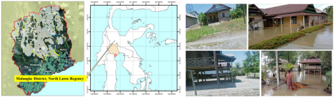
The research location, which is the population location, is in West Malangke Sub-district, North Luwu District, South Sulawesi Province, which consists of 13 villages as observation locations and 5 villages affected by floods as the main focus of observation, interviews, and surveys (Figure 1). The approach in sampling research amounted to 300 respondents with sample conditions that are known to the total population, which is divided into 5 villages, namely Cenning, Waelawi, Limbong Wara, Wara, and Pombaka.
Figure 1. Research area
The selection of the research site was based on several basic considerations, as follows: (a) has the genesis characteristics of flood events such as the rise in water level as a result of overflow of surface flow (run-off) in the watershed; (b) is a Flood Prone Area (KRB), the intensity of flood events and the magnitude of the impact caused, or relatively high disaster risk; (c) the area has a risk of flash floods; (d) the research location can be replicated model handling in the area and typology of problems from the impact of flooding in the downstream area with the potential of tidal water supported by local uniqueness of the physical characteristics of coastal land and socio-economic agrarian communities.
3.3 Method of collecting data
Data sources in the study were obtained through field observations, documents, surveys, and interviews. The data sources are as follows: (a) observation and documentation in this study were used for data needs on land conditions around the river, physical conditions of buildings, and social, cultural, and economic conditions of the community; (b) respondent surveys and interviews, distributing questionnaires and interviews, were conducted to obtain data on the physical condition of the area, community and government adaptation activities, and spatial policies. Indicators were measured with a Likert scale through questions in the questionnaire and scored: (1) strongly disagree; (2) disagree; (3) disagree and disagree; (4) agree; (5) strongly agree.
3.4 Data analysis method
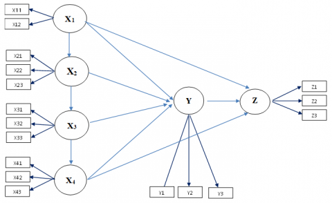
The analysis method uses quantitative descriptive analysis of the data collected from the survey, which is then examined and integrated into Smart-PLS 3. The Structural Equation Modeling (SEM-PLS) process is carried out simultaneously with measurement and structural processes to build a model [25]. This concept is a relationship model of adaptation in the form of disaster resilience. The variables in this study are flood technology (X1) as independent or exogenous variables, disaster management (X2), local wisdom (X3), spatial arrangement (X4), disaster mitigation and adaptation (Y) as intervening variables, and flood disaster area resilience (Z) as dependent or endogenous variables. The following equation model is as follows:
Z = X1 + X4 + Y + e (1)
Y = X1 + X2 + X3 + X4 + e (2)
X2 = X1 + e (3)
X3 = X4 + e (4)
The following is a conceptual proposal for the relationship model and variables and their indicators based on a literature review in the theory of variable integration in background point 2, and the analysis process is carried out using path equations with the Partial Least Squares Structural Equation Modeling method (SmartPLS 3), see Figure 2.
Figure 2. The concept of the proposed research model
4.1 Factors influencing disaster adaptation, mitigation, and resilience in flood disaster areas
4.1.1 Measurement model analysis (outer model)
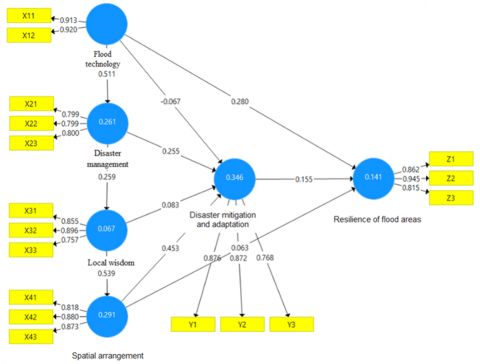
The results of checking the convergent validity of all indicators already have criteria for the outer loading value to be ≥ 0.7, meaning that the indicator is a valid construct. Furthermore, the assessment of discriminate validity based on the latent construct of flood technology has an AVE square root value of 0.917, the AVE value of the disaster adaptation and mitigation variable is 0.840, the AVE value of the flood area resilience variable is 0.876, and local wisdom has an AVE value of 0.838, where the latent construct correlation value has a high value compared to the disaster management value, which only has an AVE value of 0.799 (see Table 1). The results of discriminant validity through the Fornell-Lacker criteria for latent constructs of flood technology, disaster adaptation and mitigation, flood area resilience, local wisdom, and disaster management have good discriminant validity values.
4.1.2 Structural model analysis (inner model)
The value of determination in the endogenous construct of disaster mitigation can be supported as a link between variables, with a strong relationship reaching 33.7%. The adjusted R2 value on the endogenous construct of disaster resilience shows that this construct can be supported by exogenous variables, with moderate reaching 14.1%. The R2 adjusted value of the endogenous disaster management construct shows that the exogenous construct is strong enough to reach 26.1%. Furthermore, the adjusted R2 value on the endogenous construct of spatial planning shows that this exogenous construct can be supported by a fairly strong variable, only reaching 29.1%.
In Table 2 and Figure 3, the path coefficient results indicate that all ten proposed hypotheses are supported. Specifically, disaster adaptation and mitigation significantly enhance flood area resilience, while local wisdom does not exert a significant influence on disaster adaptation and mitigation but significantly impacts spatial planning. Spatial planning, in turn, significantly influences disaster adaptation and mitigation but does not directly affect flood area resilience. Disaster management emerges as a significant driver of both disaster adaptation and mitigation and local wisdom. Interestingly, flood technology shows no direct impact on disaster adaptation or mitigation but significantly influences disaster management and flood area resilience. These findings underscore the complex interplay of factors influencing disaster resilience strategies in flood-prone areas.
Table 1. Internal consistency reliability
|
Variable |
Cronbach's Alpha |
rho_A |
CR |
AVE |
|
Disaster adaptation and mitigation |
0.789 |
0.792 |
0.878 |
0.706 |
|
Resilience of flood areas |
0.849 |
0.899 |
0.908 |
0.767 |
|
Local wisdom |
0.786 |
0.783 |
0.876 |
0.702 |
|
Disaster management |
0.722 |
0.731 |
0.841 |
0.639 |
|
Space arrangement |
0.820 |
0.825 |
0.893 |
0.735 |
|
Flood technology |
0.810 |
0.811 |
0.913 |
0.840 |
Notes: Loading Factor >0.70, CR>0.70, AVE>0.50 [25]
Table 2. Results of path coefficient values and p values
|
Path |
Sample Mean (M) |
T Statistics |
P Values |
Effect/Sig |
|
Disaster adaptation and mitigation -> Resilience of flood areas |
0.161 |
2.249 |
0.025 |
Positive/Significant |
|
Local wisdom -> Disaster adaptation and mitigation |
0.084 |
1.120 |
0.263 |
Negatif /Not significant |
|
Local wisdom -> Spatial arrangement |
0.537 |
9.096 |
0.000 |
Positive/Significant |
|
Disaster management -> Disaster adaptation and mitigation |
0.260 |
2.981 |
0.003 |
Positive/Significant |
|
Disaster management -> Local Wisdom |
0.261 |
4.262 |
0.000 |
Positive/Significant |
|
Spatial arrangement -> Disaster adaptation and mitigation |
0.448 |
4.758 |
0.000 |
Positive/Significant |
|
Spatial arrangement -> Resilience of flood areas |
0.058 |
0.717 |
0.474 |
Negatif /Not significant |
|
Flood technology -> Disaster adaptation and mitigation |
-0.065 |
1.036 |
0.301 |
Negatif /Not significant |
|
Flood technology -> Resilience of flood areas |
0.290 |
4.646 |
0.000 |
Positive/Significant |
|
Flood technology -> Disaster management |
0.513 |
10.319 |
0.000 |
Positive/Significant |
Notes: **t-value is below 1.96 and *p<0.05. Source: Author elaborator
Figure 3. Results of tests of the influence between variables and the influence of indicators on variables
4.2 Adaptation and mitigation model in the form of resilience in areas prone to flash flood disasters
The relationship between adaptation and mitigation has an effect on resilience, and this finding is in line with the researches [9, 11]. The study emphasizes that disaster mitigation and adaptation are community-driven responses essential for addressing environmental challenges. Technical support such as disaster training, early warning systems, shelters, and insurance plays a vital role in enhancing resilience to floods. This resilience is marked by sustained economic activities, adjustments in social and economic aspects post-flood, and robust infrastructure. These dynamics catalyze gradual social, economic, and cultural transformations in West Malangke Subdistrict. They include the preservation of traditional stilted houses adapted for floods and a shift from dry to wet farming practices, enhancing community resilience against flood-prone environments through adaptive transitions.
The relationship between local wisdom and adaptation and mitigation is not in line with research [22] on local wisdom in conservation. The findings of this study demonstrate that local wisdom practiced by communities along riverbanks involves utilizing the land for economic purposes, such as cultivating crops like corn and sweet potatoes. However, this economic utilization often prioritizes economic value over river ecology, potentially leading to agricultural losses during flooding events. Traditions like building houses, farming, gardening, and fishing along riverbanks reflect local wisdom but do not directly contribute to adaptation and mitigation efforts. Instead, they indirectly promote cohesive spatial planning practices that serve as a model for regional sustainability and foster positive community relationships.
The relationship between local wisdom and spatial planning has an influence; this finding is in line with research [21]. The findings of this study underscore that local wisdom, characterized by traditions such as building houses on riverbanks, farming, gardening, and fishing along rivers, plays a pivotal role in shaping spatial planning that harnesses the riverbank environment sustainably. This integration of local wisdom into spatial planning reflects a positive relationship, particularly in West Malangke Subdistrict, where community practices like cage cultivation, fishing, and controlled crop farming along rivers contribute to the sustainability of riparian areas. This approach emphasizes the importance of preserving and integrating traditional practices with modern spatial planning for sustainable riverbank management.
The relationship between disaster management and adaptation and mitigation has an influence, and this finding is in line with research by Hariadi et al. [15]. The survey results highlight significant deficiencies in community preparedness for disasters. Specifically, 10.54% of respondents lack early warning systems or designated disaster response posts, relying instead on temporary facilities such as the sub-district office during emergencies. Regarding disaster mitigation and adaptation, the survey reveals a notable lack of knowledge and experience among respondents regarding flood disasters, with 49% having completed only high school, 20% junior high school, and 15% elementary school. This educational profile affects their ability to effectively respond to and recover from flood events. Additionally, efforts to mitigate floods through physical infrastructure remain insufficient, primarily focusing on temporary river management structures that are vulnerable to flash floods. These findings underscore the urgent need for improved community education and disaster management infrastructure, including early warning systems, disaster response facilities, and insurance, to enhance resilience in disaster-prone areas. Despite these challenges, the community's response to flooding shows growing awareness and local initiatives aimed at understanding and addressing disaster risks.
The relationship between disaster management and local wisdom has a significant effect on local wisdom. This finding is in line with research [16] and explains the new theoretical development of Hariadi et al. [15]. The study findings demonstrate that the community possesses local knowledge about their ecosystem and actively works to mitigate safety risks posed by flood disasters. This local wisdom encompasses the community's deep understanding of their environment and its conditions, representing regional knowledge that has been preserved over time. A robust disaster management strategy should acknowledge the pivotal role of the Malangke Sub-district community, leveraging their social and cultural capital embedded in this local wisdom. This approach ensures that disaster plans are contextualized and effectively integrate community insights and practices into mitigation and adaptation efforts.
The relationship between spatial planning and disaster adaptation and mitigation has a significant effect, and this finding is in line with research [18]. The study highlights the critical role of spatial aspects in disaster mitigation and adaptation for both government and community members. It reveals that 78.33% of the community values planning, utilization, and control of disaster-prone areas, while 78% attribute increasing flood-prone areas to insufficient spatial control. Limited knowledge and experience of flood disasters significantly affect mitigation and adaptation efforts before and after flooding. Integrating spatial knowledge with effective strategies can reduce both physical and non-physical impacts of floods. Emphasizing disaster-prone conditions in spatial planning supports ecosystem balance and environmental capacity, fostering sustainable flood area management and aligning government and community efforts.
Spatial planning relationships have no effect on the resilience of flood areas, where the findings are consistent with Brunetta and Caldarice [26]. The study findings indicate that while spatial planning does not directly correlate with the severity of flood disasters, effective disaster mitigation and adaptation are crucial to managing disaster severity. This indirect relationship underscores the need for proactive disaster preparedness and response strategies to mitigate future flood risks and enhance resilience.
The flood technology relationship has not had an influence on significant disaster adaptation and mitigation, where the findings are in line with research [27]. The research findings emphasize that there is a significant gap in addressing the need for weather modification and technological engineering in flood prevention and control methods. This gap highlights a critical area where substantial budgetary and policy efforts are required. Currently, both the community and government lack the financial resources necessary for advanced flood technologies, posing a significant challenge. Limited budget allocations and insufficient political support further constrain efforts to mitigate and adapt to flood disasters effectively. Consequently, there is a pressing need to leverage community knowledge and experience in managing flood disasters amidst these financial limitations.
Flood technology has a significant impact on disaster management, and the findings are in line with research [12]. The research findings underscore that technological aspects exacerbate flooding, necessitating disaster management efforts that are cost-effective. These efforts include enhancing management information systems, providing technical guidance (such as disaster training) at the community level, and establishing early warning systems. These systems should be strategically located in high-density areas, worship centers, health facilities, and government offices to disseminate critical information. Leveraging social media and establishing disaster response posts are also crucial.
Given the limited budgetary resources of both the community and government for flood technology, addressing this challenge remains a significant barrier to enhancing resilience in flood-prone areas. Therefore, effective disaster management must integrate community knowledge and wisdom to effectively mitigate and manage flood disasters under these constraints.
Flood technology has a significant impact on flood disaster resilience. These findings develop and explain the research of Wahyuni et al. [28]. The study findings highlight that flood technology significantly impacts the resilience to flood disasters. Despite budgetary constraints, social capital emerges as crucial, fostering community resilience through collaborative efforts to enhance infrastructure. The relationship between flood technology and flood severity is mediated by regional resilience efforts focused on disaster mitigation and adaptation, underscoring the interconnected nature of these factors in building community resilience against floods.
In the outlined model of disaster adaptation and management, several inherent relationships stand out: first, efforts in disaster adaptation and mitigation positively correlate with resilience against floods, highlighting the importance of effective strategies in addressing disaster risks. Second, effective disaster management not only supports the intensity of adaptation and mitigation efforts but also collaborates with local wisdom to integrate local values into mitigation strategies. Third, effective spatial arrangements facilitate not only the implementation of adaptation and mitigation but also play a role in enhancing community resilience against disasters. Meanwhile, flood technology, though not directly influencing adaptation and mitigation efforts, significantly strengthens resilience against floods and supports effective disaster management strategies. This scheme underscores the importance of an integrated and holistic approach to managing disaster risks, utilizing various aspects such as local wisdom, technology, and spatial planning to enhance community resilience to disasters.
The interplay between disaster management and spatial planning significantly impacts disaster mitigation and adaptation. This relationship, mediated through local wisdom, shapes the approach to spatial planning. Meanwhile, the influence of flood technology on adaptation varies in its direct and indirect effects. This model reflects community and governmental perspectives on flash floods, emphasizing disaster resilience through two main aspects: direct management and spatial planning control of disaster impacts, fostering resilience in West Malangke District, North Luwu County.
The research emphasizes the critical relationship between disaster management, spatial planning, and local wisdom in mitigating and adapting to flash flood disasters in North Luwu, particularly in the Malangke sub-district. The study highlights how changes in climate and land use have increased the vulnerability of these areas, requiring effective disaster resilience strategies. By integrating local knowledge with modern disaster management practices and spatial planning, the research proposes a model for sustainable development in flood-prone regions. This approach not only addresses immediate disaster impacts but also promotes long-term community resilience and sustainability, offering a comprehensive framework for managing flood risks in similar contexts globally.
The research makes a significant contribution to policy and research in disaster management and spatial planning in flood-prone areas like North Luwu. It underscores the importance of integrating effective disaster management, sustainable spatial planning, and local wisdom in addressing challenges such as flash floods. By combining rich local knowledge with modern practices, this research not only offers solutions to reduce disaster vulnerability but also promotes sustainable development and enhances overall community resilience. This enriches policy insights and provides empirical groundwork for designing relevant mitigation and adaptation strategies in response to increasingly complex climate changes and environmental dynamics.
We express our gratitude to our research team colleagues for their dedication and contributions to this study. We also thank the government of North Luwu Regency, the community of West Malangke District, and the Postgraduate Program of Bosowa University Makassar for their invaluable support in data provision and assistance in the research writing process, which is a part of the doctoral requirements in the Regional and Urban Planning Doctoral Program.
[1] Short, F.T., Neckles, H.A. (1999). The effects of global climate change on seagrasses. Aquatic Botany, 63(3-4): 169-196. https://doi.org/10.1016/S0304-3770(98)00117-X
[2] Karl, T.R., Trenberth, K.E. (2003). Modern global climate change. science, 302(5651): 1719-1723. https://doi.org/10.1126/science.1090228
[3] Strand, R., Kovacic, Z., Funtowicz, S., Benini, L., Jesus, A. (2022). Exiting the Anthropocene? Exploring fundamental change in our relationship with nature. European Environment Agency, Briefing.
[4] Bolan, S., Padhye, L.P., Jasemizad, T., Govarthanan, M., Karmegam, N., Wijesekara, H., Amarasiri, D., Hou, D., Zhou, P., Biswal, B.K., Balasubramanian, R., Wang, H., Siddique, K.H.M., Rinklebe, J., Kirkham, M.B., Bolan, N. (2024). Impacts of climate change on the fate of contaminants through extreme weather events. Science of the Total Environment, 909: 168388. https://doi.org/10.1016/j.scitotenv.2023.168388
[5] Reay, D., Sabine, C., Smith, P., Hymus, G. (2007). Spring-time for sinks. Nature, 446: 727-728. https://doi.org/10.1038/446727a
[6] Hirabayashi, Y., Mahendran, R., Koirala, S., et al. (2013). Global flood risk under climate change. Nature Climate Change, 3(9): 816-821. https://doi.org/10.1038/nclimate1911
[7] Marfai, MA., King, L., Singh, L. P., Mardiatno, D., Sartohadi, J., Hadmoko, D.S., Dewi, A. (2008). Natural hazards in central Java province, Indonesia: An overview. Environmental Geology, 56: 335-351. https://doi.org/10.1007/s00254-007-1169-9
[8] Manaf, M., Muhibuddin, A., Suriandjo, H.S., Muspida, A., Widodo, S., Abdulbar, F. (2022). Mitigation and public coordination for Flood Disaster Risk Reduction (FDRR) in the implementation of North Luwu sustainable development. IOP Conference Series: Earth and Environmental Science, 1109(1): 012018) https://doi.org/10.1088/1755-1315/1109/1/012018
[9] Leichenko, R. (2011). Climate change and urban resilience. Current Opinion in Environmental Sustainability, 3(3): 164-168. https://doi.org/10.1016/j.cosust.2010.12.014
[10] Wang, W., Wei, H., Hassan, H., He, X. (2024). Research progress and prospects of urban resilience in the perspective of climate change. Frontiers in Earth Science, 12: 1247360. https://doi.org/10.3389/feart.2024.1247360
[11] Einecker, R., Kirby, A. (2020). Climate change: A bibliometric study of adaptation, mitigation and resilience. Sustainability, 12(17): 6935. https://doi.org/10.3390/su12176935
[12] McCallum, I., Liu, W., See, L., et al. (2016). Technologies to support community flood disaster risk reduction. International Journal of Disaster Risk Science, 7: 198-204. https://doi.org/10.1007/s13753-016-0086-5
[13] Sharma, K., Anand, D., Sabharwal, M., Tiwari, P.K., Cheikhrouhou, O., Frikha, T. (2021). A disaster management framework using internet of things-based interconnected devices. Mathematical Problems in Engineering. https://doi.org/10.1155/2021/9916440
[14] Zevenbergen, C., Gersonius, B., Radhakrishan, M. (2020). Flood resilience. Philosophical Transactions of the Royal Society A, 378(2168): 20190212. https://doi.org/10.1098/rsta.2019.0212
[15] Hariadi, U., Suratman, S., Gunawan, T., Armawi, A. (2020). Kearifan lokal komunitas sebagai modal sosial alam manajemen bencana alam. Majalah Geografi Indonesia, 33(2): 1-7. https://doi.org/10.22146/mgi.48548
[16] Kusumasari, B., Alam, Q. (2012). Local wisdom-based disaster recovery model in Indonesia. Disaster Prevention and Management: An International Journal, 21(3): 351-369. https://doi.org/10.1108/09653561211234525
[17] Rahmah, M., Sulistyono, A. (2024). The integration of traditional knowledge and local wisdom in mitigating and adapting climate change: Different perspectives of indigenous peoples from java and Bali Island. In Traditional Knowledge and Climate Change: An Environmental Impact on Landscape and Communities, pp. 61-80. https://doi.org/10.1007/978-981-99-8830-3_4
[18] Meng, M., Dabrowski, M., Stead, D. (2020). Enhancing flood resilience and climate adaptation: The state of the art and new directions for spatial planning. Sustainability, 12(19): 7864. https://doi.org/10.3390/su12197864
[19] Rega, C., Bonifazi, A. (2020). The rise of resilience in spatial planning: A journey through disciplinary boundaries and contested practices. Sustainability, 12(18): 7277. https://doi.org/10.3390/su12187277
[20] Wijaya, N., Bisri, M.B.F., Aritenang, A.F., Mariany, A. (2017). Spatial planning, disaster risk reduction, and climate change adaptation integration in Indonesia: Progress, challenges, and approach. In Disaster Risk Reduction in Indonesia: Progress, Challenges, and Issues, pp. 235-252. https://doi.org/10.1007/978-3-319-54466-3_9
[21] Kristiyanto, E.N. (2020). Local wisdom and role of society in spatial planning in the region. In International Conference on Law, Governance and Islamic Society (ICOLGIS 2019), pp. 15-24. https://doi.org/10.2991/assehr.k.200306.173
[22] Simarmata, D.P., Indrawati, D.R. (2022). Using local wisdom for climate change mitigation. IOP Conference Series: Earth and Environmental Science, 1109(1): 012004. https://doi.org/10.1088/1755-1315/1109/1/012004
[23] Mulyadi, M. (2011). Penelitian kuantitatif dan kualitatif serta pemikiran dasar menggabungkannya. Jurnal Studi Komunikasi dan Media, 15(1): 128-137. https://doi.org/10.31445/jskm.2011.150106
[24] Creswell, J.W. (2012). Research design. Journal of Investigative Surgery, 25(5): 279-280. https://doi.org/10.3109/08941939.2012.723954
[25] Hair, J.F., Risher, J.J., Sarstedt, M., Ringle, C.M. (2019). When to use and how to report the results of PLS-SEM. European Business Review, 31(1): 2-24. https://doi.org/10.1108/EBR-11-2018-0203
[26] Brunetta, G., Caldarice, O. (2019). Putting resilience into practice. The spatial planning response to urban risks. In Urban resilience for Risk and Adaptation Governance: Theory and Practice, pp. 27-41. https://doi.org/10.1007/978-3-319-76944-8_3
[27] Kurniati, D., Nugroho, Y.A., Nurbaya, F., Setyawati, E., Asriati, Y. (2020). Lintas Keilmuan Memandan Kebencanaan. https://penerbitpace.com/?katalog-buku=lintas-keilmuan-memandang-kebencanaan.
[28] Wahyuni, D., Syamsunasir, S., Subiyanto, A. (2022). Pemanfaatan sistem informasi bencana banjir di kabupaten bandung untuk mewujudkan masyarakat tangguh bencana. PENDIPA Journal of Science Education, 6(2): 516-521. https://doi.org/10.33369/pendipa.6.2.516-521