Victor Gabriel Castillo-Rudas![]() | Marco Antonio Cotrina-Teatino*
| Marco Antonio Cotrina-Teatino*![]() | Jairo Jhonatan Marquina-Araujo
| Jairo Jhonatan Marquina-Araujo![]()
© 2024 The authors. This article is published by IIETA and is licensed under the CC BY 4.0 license (http://creativecommons.org/licenses/by/4.0/).
OPEN ACCESS
The objective of the research was to implement slope stabilization systems to prevent accidents in the expansion and improvement project of Campiña Huaruro, province of Caylloma, Arequipa. The methodology used was of pre-experimental design, where slope safety was evaluated within the operational jurisdiction of a mining company in high-risk sectors such as Belen, Paclla, Malata and Huaruro, based on risk maps and detailed observation. The results indicated that the systems implemented were cable-reinforced meshes for dacite rock and dynamic rockfall barriers designed for the type of andesite rock present in the project slopes. In addition, the IPERC revealed that the risk levels for the tasks performed on the slopes were 25% moderate risk and 75% low risk. As a result of these preventive measures, a reduction in the accident rate was achieved in the Huaruro project, decreasing from 17.36 to 5.20, which represents a difference of 12.16. In conclusion, the implementation of the slope stabilization system proved to be highly effective in the prevention of occupational accidents in the Huaruro expansion and improvement project.
slope, occupational safety, accidents, accident rate, risks
In the field of geotechnical engineering and mining, slope stability represents a major challenge given its direct relationship with worker safety and the sustainable development of operations [1]. Although mining represents only 1% of the global workforce, it accounts for 8% of fatal accidents in the workplace [2]. This highlights the need to implement effective prevention strategies, positioning mining not only as an essential economic pillar but also as a sector where occupational health and safety is paramount [3].
The challenge of slope stability is particularly evident in the expansion and improvement project in the Belén, Paclla, Malata and Huaruro sectors of the Campiña, located in the district of Tapay, province of Caylloma, Arequipa. The region, characterized by its complex topography and a climate prone to heavy rainfall, has been the scene of recurrent landslides, causing not only significant loss of material and machinery, but also unfortunate occupational accidents [4-7]. This problem leads to the implementation of risk prevention and management strategies by the contractor company.
The expansion of the Huaruro Campiña expansion and improvement project is 2 kilometers. The study context is characterized by 4 zones: landslide (A) located at 2935 msnm, transport (B), material accumulation (C) and rockfall (D) (see Figure 4). The predominant lithology in the area is andesites (Tm-Vta) [8] and dacites (TQ-vba) [9], being andesites in the upper part of the slope and dacites at the base of the slope, whose RMR geomechanical classification is type III for both being a regular rock type. The topography is very steep, with an average angle of more than 85 degrees in the rockfall zone. There is a high level of weathering of the rocks [10], with probable loss of shear strength at the contact of the andesites above the dacites, presence of multiple faults and fractures with dip and sub vertical orientation facilitating water infiltration and weakening the structure of the rock mass [11].
In response to this problem, the International Council on Mining and Metals (ICMM) has proposed guidelines to intensify the management of critical controls [12]. At the same time, the General Mining Law (Law No. 27651) in Peru requires mining companies to protect workers, nearby communities, and the environment [13]. However, the persistence of slope slides as a hazard underlines the importance of a thorough risk assessment and the development of prevention strategies adapted to the complexity of each scenario [14-16].
In this context, the contributions of Carreño [17] and García [5], underline the need for protocols adapted to the complexity of each situation, focusing on specific measures to prevent landslides. The study by Peng et al. [18] has advanced the evaluation of slope failure risks, incorporating groundwater level variability and soil shear strength parameters. These findings emphasize the critical influence of hydrologic factors on slope stability. In addition, research conducted by Shibata et al. [19] highlights the need for high-resolution and sensitive slope sensors to prevent accidents. These studies provide evidence of a large proportion of accidents occurring during the construction of slope stabilization structures, often due to restricted workspaces and sudden failures [20].
This article discusses how slope slides represent a challenge at the Caylloma-Arequipa mining project, highlighting the reduction of accidents through the use of stabilization systems and effective risk management. The purpose is to offer a clear and applicable guide for slope stabilization, highlighting the need for a joint work that integrates technical, geological, and environmental specialties. This work not only enriches the debate on mining safety, but also proposes a model that can be replicated in other mining projects to stabilize their slopes to reduce accidents and manage risks, aiming for a safer and more responsible future [21, 22].
The structure of this study is organized as follows: Chapter 2 describes the materials and methods used; Chapter 3 presents the results and discussions; Chapter 4 summarizes the main conclusions of the study; and finally, Chapter 5 lists the bibliographical references consulted.
2.1 Research design
The research adopted a quantitative approach with a pre-experimental design, aimed at evaluating the impact of slope stabilization measures on the reduction of occupational accidents in the mining company operating in the Belén, Paclla, Malata, Huaruro sectors of the Tapay district, Caylloma-Arequipa province.
2.2 Population and sample
The study population included all unsafe conditions identified in the work zone of the mining company. The sample focused on high-risk slopes identified in the geographical location of the work zone.
2.3 Unit of study
The unit of analysis was located in the district of Tapay, province of Caylloma, Arequipa region, where the slopes under study are located.
2.4 Instrumentation and data collection
A detailed risk map was used as the main tool for the identification and analysis of slope hazards. This map was developed from direct observation and field data collection, which allowed obtaining an accurate graphical representation of the distribution and severity of risks in the study area [23, 24]. Complementarily, the IPERC matrix was used for a systematic evaluation of the slopes of the mining company [25, 26].
2.5 Methodology of analysis
For the analysis of the data collected, a quantitative approach was used to quantify the accident rate before and after the implementation of slope stabilization measures. This analysis included the use of descriptive statistics, which employed Student's t-test for related samples, with the objective of determining significant differences between the accident rate before and after the implementation of slope stabilization systems [27, 28].
2.6 Procedure
The research was carried out in several stages, as shown in Figure 1.
Figure 1. Flow chart of the investigation
2.7 Slope stabilization systems
Two slope stabilization systems were implemented: 1) cable reinforced mesh and 2) dynamic rockfall barriers.
The cable reinforced mesh is a type of solution that consists of a mesh attached to the rock slope face and does not allow the detachment or fall of the blocks since the cables are anchored to the anchor bolts in the rock slope (see Figure 2) [29].
Figure 2. Mesh reinforced with cables
The dynamic rockfall barriers are reinforced dynamic meshes and can be placed at different heights since they present metallic columns of great resistance and can cushion the falls of small and medium-sized blocks, even at great heights (see Figure 3) [30].
Figure 3. Dynamic barrier against rock falls
3.1 Geotechnical diagnosis and characterization of the slopes
The study began with an exhaustive geotechnical diagnosis of the slopes, focusing on topographic and geomorphological characteristics including slope angle, rock type and material stability. Figure 4 illustrates in detail the zones of detachment (A), transport (B), accumulation (C) and areas where rockfall events were previously initiated (D). Zone A is the elevation of the access road in this sector with an altitude of 2935 msnm, the width of the landslide measured at the road crossing was 50 m, the collapse trajectory initiated from a near vertical (>85°) upper rock massif wall with a steep rock slope (40° slope and 55 m long), the distance measured from the head of the main escarpment to the foot of the accumulatio n zone is approximately 200 m, with an average slope of 55 degrees. Zone B has a thin layer of coarse colluvial material, the material being extremely loose and erodible, especially when disturbed. Zone (C) are slope zones that are produced by accumulation of material and zone (D) are source zones where previous rockfall events were initiated.
Figure 4. Orthophoto of the landslide zone (progressive 0+500)
The geotechnical analysis was deepened through the study of discontinuities and the application of the RMR classification system to evaluate rock quality. Both andesites (located at the top of the slope) and dacites (located at the base of the slope) were found to have "Fair" quality, indicating specific challenges, but also potential for improvement with appropriate interventions. Figure 5 and Table 1 present a detailed geological profile and a geomechanical evaluation to support stabilization strategies.
Table 1. Geomechanical classification
|
Properties |
Andesite (Tm-Vta) |
Dacite (TQ-vba) |
|
Rock type |
III |
III |
|
Rock quality |
Regular |
Regular |
|
RMR |
59 |
51 |
|
GSI |
54 |
46 |
|
UCS (Mpa) |
150 |
80 |
|
Cohesion (kg/cm2) |
0.666 |
0.337 |
|
Friction (°) |
62.32 |
56.58 |
|
Strain modulus E (Mpa) |
8183.02 |
4618.05 |
|
Disturbance factor |
0.7 |
0.7 |
Figure 5. Geological profiles with subvertical geological structures
Gonzales [31] highlights the importance of analyzing stresses and deformations to understand the risks associated with slopes. This approach allowed the identification of unstable columnar blocks and subvertical cuts in the sector 0+500 to 0+600, suggesting a critical state of geotechnical criticality.
Figure 6 shows the diagnosis of the slope in sector 7+930 - 7+960 in section 2, where a deep slope cut of the quarry excavation is observed, it presents subvertical cuts and monitoring is recommended, as well as signage to restrict access.
Figure 6. Slope in sector 7+930 - 7+960 in section 2
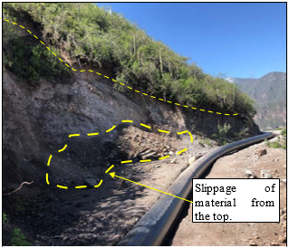
Figure 7. Slope in sector 8+270 - 8+290 in section 2
Figure 7 shows recently detached material in sector 8+270 - 8+290 in section 2, where there is a cut in the slope because of excavation for the pipeline shaft, material falling to the ground because of rainfall, landslides, and possible seismic events, indicating the need for constant monitoring to detect any signs of emerging instability in the slope.
The analysis in sector 10+210 - 10+260 in section 2, shown in Figure 8, shows the slope cut as a result of the excavation for the pipe axis, rock fragmentation, fractured and altered material with simple compressive strength of 5 to 25 Mpa, where it is recommended to remove the material and remove the upper part of the overburden, making a 45° chamfer cut, as well as cutting the altered material at (0.33H:1V) in the subvertical cuts.
Figure 8. Slope in sector 10+210 - 10+260 in section 2
In sector 7+930-7+960, the slope is unstable due to the subvertical cut that was the result of the excavation of the quarry to fill the material. In sector 8+270-8+290, the slope has fallen rock fragments because of the earthquake and in sector 10+210-10+260 the slope is currently being cut and fragmented for the axis of the pipeline.
3.2 Hazard mapping and slope stabilization systems
Based on geologic mapping, field observations and slope characteristics, analyses indicate that rock falls are mainly attributed to the intersection of discontinuities and formation of a blocky rock mass structure, where the failure modes are mainly wedge and planar instabilities with overturning associated with subvertical discontinuities in favor of the slope. Several rocks located in the landslide detachment zone (zone A) have been observed to be unstable, with very high rockfall hazard. These boulders vary in size from ~0.5 m3 to ~2m3. Likewise, there are localized areas that have blocks or groups of blocks, with volumes greater than 100 m3. There are also landslide types: Low (B), flat to undulating topography, with minor mountainous parts, the terrain shows no evidence of previous landslide activity. Medium (M), slopes with old evidence of landslide activity, but which have not shown movement in the last 100 years. High (A), steep and abrupt relief, slopes frequently subject to landslide activity, landslide activation results when events with recurrence intervals of less than 10 years occur. Very high (MA), very steep and rugged relief, slopes with fault zones, intensely weathered and/or altered, saturated and highly fractured rock masses, actively sliding slopes, movements may be continuous or stationary (see Figure 9).
Figure 9. Hazard map in interest (progressive 0+200 to 1+200)
Figure 10. Landslide zone and geological structures
Locally there is the presence of diagonal fracturing with an inclination of approximately 90°, structurally they could be local geological faults, but their formation and deposition of the volcanic rock formed columnar structures of columnar disjunction type, where the degree of fracturing consists of vertical openings. Figure 10 shows the most important and longest structures in the work zone, where very steep slopes to verticality are observed, presenting unstable blocks and structures in the form of vertical columns.
Some causes of triggering factors are the high level of weathering, presence of multiple faults and tension cracks which facilitate water infiltration and weaken the rock mass structure. Along the slope there is the presence of differential disintegration and erosion along the andesite and dacite contact zone (see Figure 11). The area investigated is characterized by high seismic activity. According to records of the Geophysical Institute of Peru (IGP), in the first three months of 2019, 11 earthquakes with magnitudes between 3.4 and 5.4 were reported within a radius of 100 km from the study site.
Figure 11. Level of weathering in the research area
The diagnosis showed that the topography is very steep, with an average angle of more than 85 degrees in the landslide zone. High level of weathering of local rocks including the presence of multiple faults and fractures with vertical and subvertical dip orientation facilitating rockfall. The presence of a geological contact (andesite rocks on top of dacite rocks) characterized by very high weathering, with loss of shear strength. Occurrence of heavy rainfall episodes in the days and hours prior to the collapse, and the presence of a preferential flow of surface water in the direction of the unstable zone. Variable accident rate between 2018 to 2021, with a range of 3 to 8.
Three corrective measures were proposed to have a safe zone. These measures were precautionary, material removal measure and stabilization measure (see Table 2). An approach called "critical control management" was mentioned in previous studies to improve management control over infrequent but potentially catastrophic incidents [4]. The implementation of reinforced mesh, dynamic rockfall barriers and controlled blasting techniques are directly aligned with the identified slope hazards, providing an effective response to mitigate the likelihood of landslides and rockfalls.
Table 2. Slope stabilization measures
|
Precautionary Measures |
Loose Material Removal Measures |
Stabilization Measures |
|
Install caution signs along the road to alert personnel of rockfall hazards in the area. Inspect the slope at regular intervals (daily/weekly). Extend these inspections to other potentially unstable sites located along the existing access road. |
Controlled blasting. Untie loose blocks. Clearing of pedestrian access road. |
Reinforced wire mesh. Dynamic rockfall barriers. |
3.3 Diagnosis and accident reduction after implementation of the slope stabilization system
Table 3 illustrates a detailed IPERC evaluation of the new slope diagnosis of the mining company. It shows the tasks performed at the slope level, differentiating between routine and non-routine activities. This table highlights that, although there are hazards associated with each task, appropriate measures and protocols can reduce the risk level to "Moderate" or "Low". Table 4 presents the proposed control measures to address and mitigate the identified hazards. These measures vary from the use of contingency tools, signage, marking of hazardous areas, to the use of personal protective equipment (EPP).
Carreño [17] mentioned that the change of safety measures is part of the control of the company's occupational health and safety procedures, as well as both working hours and fatigue are conditions that increase the risk of danger.
From the proposed solution, the IPERC obtained a slope risk level of 0% of critical risks, 0% of important risks, 25% of moderate risks and 75% of low risks, thus indicating that the risks on the slopes have been significantly reduced, and the accident rate went from 17.36 to 5.20.
3.4 Statistical analysis
Rigor in the evaluation of the data was ensured by applying normality tests, a crucial preliminary step in determining the adequacy of parametric statistical methods. As shown in Table 5, two different tests were performed to assess normality: Kolmogorov-Smirnov and Shapiro-Wilk. These tests generated p-values of 0.85 and 0.44, respectively, far exceeding the conventional threshold of 0.05. These results not only indicate that the distribution of the difference in accident rates before and after the intervention significantly conforms to a normal distribution.
Table 3. IPERC evaluation
|
Task |
Hazard Description |
Type of Contact |
Probability (P) |
Severity (S) |
Risk Assessment |
Level of Risk |
|
Slope level (routine task) |
Incidents of falling to the same level |
Tc 01 Hitting against floors, gables, and cargo |
4 |
8 |
32 |
Moderate |
|
Slope level (non-routine task) |
Exposure in excavation work |
Tc 02 Psychosocial workload (schedules, overtime, rest, others) |
3 |
8 |
24 |
Moderate |
|
Slope level (routine task) |
Moving equipment |
Tc 03 Hitting against load, object, others |
1 |
6 |
54 |
Low |
|
Slope level (non-routine task) |
Loose rock |
Tc 04 Hitting against rocks |
1 |
9 |
9 |
Low |
|
Slope level (routine task) |
Adverse weather (heavy rain, fog, thunderstorm) |
Tc 05 Striking against isothermal effects of weather |
1 |
6 |
6 |
Low |
|
Slope level (non-routine task) |
Unstable surface or terrain |
Tc 06 Striking against soil strata and landslides |
2 |
8 |
16 |
Low |
|
Slope level (routine task) |
Extreme temperature |
Tc 07 Striking against isothermal effects of weather |
2 |
8 |
16 |
Low |
|
Slope level (non-routine task) |
Particulate matter (dust) |
Tc 08 Striking against soil strata |
3 |
4 |
12 |
Low |
Table 4. Control measures
|
Task |
Level of Risk |
Hazard Description |
Type of Control Implemented |
Control Measure |
|
Slope level (routine task) |
Moderate |
Incidents of falling to the same level |
Contingency tools |
Wire reinforced mesh |
|
Slope level (non-routine task) |
Moderate |
Exposure in excavation work |
Contingency tool and signage |
High strength hanging mesh |
|
Slope level (routine task) |
Low |
Moving equipment |
Marking hazardous areas and delimiting warnings. Contingency tools |
Dynamic barriers in the section of possible landslides at the same level |
|
Slope level (non-routine task) |
Low |
Loose rock |
Contingency tools and increased use of EPPS |
Dynamic barrier against falling rocks, placement of anchor bolts |
|
Slope level (routine task) |
Low |
Adverse weather (heavy rain, fog, thunderstorm) |
Contingency tools |
There will be thunderstorm detectors |
|
Slope level (non-routine task) |
Low |
Unstable surface or terrain |
Contingency measures |
There will be personnel implemented as lookouts, mesh reinforced with cables |
|
Slope level (routine task) |
Low |
Extreme temperature |
Contingency tools and contingency measures |
Work uniform with long sleeves, use of grade 70 sunscreen, high strength hanging mesh |
|
Slope level (non-routine task) |
Low |
Particulate matter (dust) |
Contingency tools |
Watering of roads and work zones. High strength hanging mesh |
Table 5. Normality test
|
DIFERENCE |
Kolmogorov-Smirnov |
Shapiro-Wilk |
||
|
Statistic |
p-value |
Statistic |
p-value |
|
|
0.18 |
0.85 |
0.93 |
0.44 |
|
Given this conformity with normality, the student’s t-test for related samples was performed, focusing on the comparison of accident rates before and after the safety measures implemented. Table 6 reveals a significant decrease in the mean accident rates, from 17.36 before the intervention to 5.20 after the intervention. The calculated t-statistic was 323.30 with an extraordinarily low p-value in both one-tailed (6.59609E-20) and two-tailed (1.31922E-19) tests, evidencing a statistically significant difference between the pre- and post-intervention periods. This reveals a significant improvement in the safety of the working environment after the implementation of slope stabilization measures. The thoroughness of the statistical analysis not only validates the effectiveness of the implemented stabilization measures, but also reinforces the importance of quantitative assessment in risk management, providing a solid basis for safety-oriented decision making in geotechnical projects.
Table 6. Test statistic
|
Statistic |
Before |
After |
|
Mean |
17.36 |
5.20 |
|
Variance |
0.023 |
0.0031 |
|
Observations |
10 |
10 |
|
Pearson correlation coefficient |
0.69 |
|
|
Hypothetical difference of means |
0 |
|
|
Degrees of freedom |
9 |
|
|
t-statistic |
323.30 |
|
|
P(T<=t) one-tailed |
6.59609E-20 |
|
|
Critical value of t (one-tailed) |
1.83 |
|
|
P(T<=t) two-tailed |
1.31922E-19 |
|
|
Critical value of t (two-tailed) |
2.26 |
In this research, slope stabilization systems were implemented to prevent accidents in the expansion and improvement project of the Huaruro countryside, province of Caylloma, Arequipa. The systems implemented were cable-reinforced meshes for dacite rock and dynamic barriers against rock falls specific to the type of andesite rock on the slopes of the project.
Based on the proposed implementation of these systems, the IPERC revealed the following risk levels for the tasks performed on the slopes: 0% critical risk, 0% major risk, 25% moderate risk and 75% low risk.
As a direct result of these preventive measures, there was a significant reduction in the accident rate at the Huaruro project, from 17.36 to 5.20. This difference of 12.16 clearly indicates that there was a significant reduction in the accident rate. This difference of 12.16 clearly indicates that the implementation of the slope stabilization system has been effective in preventing occupational accidents.
For future research, it is recommended to explore the implementation of other slope stabilization systems in different geographical areas and how they influence occupational accidents. This will allow the development of engineering practices that ensure safe working environments in the prevention of accidents.
|
SRL |
Limited Liability Company |
|
IPERC |
Hazard Identification and Risk Assessment and Controls |
|
MPa |
Mega Pascals |
|
Km |
Kilometers |
|
EPP |
Personal Protective Equipment |
|
m3 |
Cubic Meters |
[1] Santos, P. (2020). Prevención de accidentes por deslizamiento de taludes mediante uso de radar en Unidad Minera Colquijirca II Sociedad Minera el Brocal - Cerro de Pasco. Piura. https://repositorio.unp.edu.pe/handle/20.500.12676/2942.
[2] OIT. (2016). Medidas de seguridad en el rubro de minería. Suiza. https://www.oitcinterfor.org/sites/default/files/salud_seg_mineria.pdf.
[3] Arango, S., Cotrina, M., Marquina, J., Portilla, H., Torres, C., Vega, J. (2023). Estimating and economic impact of mining accidents: A case study from Peru. International Journal of Safety and Security Engineering, 13(3): 539-545. https://doi.org/10.18280/ijsse.130316
[4] Ames, C. (2021). Aplicación de la gestión de controles críticos con la metodología Bow Tie enfocado a la prevención de accidentes por deslizamiento de taludes en minería de tajo abierto. Huánuco. https://hdl.handle.net/20.500.12394/10039.
[5] García, J. (2020). Evaluación para la gestión de riesgos y control de erosión en taludes. Bogotá. http://hdl.handle.net/10654/38016.
[6] Figueroa, K. (2018). Evaluación de la estabilidad de taludes en las operaciones mineras de la cantera los Chancas III 5hnos, distrito de Bambamarca, departamento de Cajamarca, 2017. Cajamarca. https://hdl.handle.net/20.500.12990/7084.
[7] Yang, H., Wu, Q., Dong, J., Xie F., Zhang, Q. (2023). Landslide risk mapping using the weight-of-evidence method in the Datong Mining Area, Qinghai province. Sustainability, 15(14): 11330. https://doi.org/10.3390/su151411330
[8] Celimar, A., Gindri, C., Silva, M., Silva, L., Homrich, I., Muller, R. (2020). Application of andesite rock as a clean source of fertilizer for eucalyptus crop: Evidence of sustainability. Journal of Cleaner Production, 256: 120432. https://doi.org/10.1016/j.jclepro.2020.120432
[9] Rupar, V., Čebašek, V., Milisavljevic, V., Stevanovic, D., Zivanovic, N. (2021). Determination of mechanical properties of altered dacite by laboratory methods. Minerals, 11(8): 813. https://doi.org/10.3390/min11080813
[10] Colman, S. (1981). Rock-weathering rates as functions of time. Quaternary Research, 15(3): 250-264. https://doi.org/10.1016/0033-5894(81)90029-6
[11] Violay, M., Gibert, B., Mainprice, D., Burg, J. (2015). Brittle versus ductile deformation as the main control of the deep fluid circulation in oceanic crust: Porosity at brittle-ductile transition. Geophysical Research Letters, 42(8): 2767-2773. https://doi.org/10.1002/2015GL063437
[12] Scharwey, K., Dodd, K. (2022). ICMM publishes 2021 safety performance data of members. ICMM. https://www.icmm.com/en-gb/news/2022/2021-safety-performance.
[13] Minem. (1992). Ley general de minería texto único ordenado. MINEM. http://www.minem.gob.pe/minem/archivos/file/Mineria/PDAC2017/ESP_008.pdf.
[14] OSINERMING. (2010). Panorama de la Minería en el Perú. https://www.osinergmin.gob.pe/seccion/centro_documental/Institucional/Estudios_Economicos/Libros/Libro_Panorama_de_la_Mineria_en_el_Peru.pdf.
[15] Cangahuala, J., Salas, V. (2022). Sistema de gestión de seguridad y salud ocupacional para la prevención de accidentes laborales en empresas mineras. Revista de Investigación Científica y Tecnológica Llamkasum, 3(1): 112-118. https://doi.org/10.47797/llamkasun.v3i1.90
[16] Quispe, E. (2023). Implementación del sistema de gestión de seguridad y salud en el trabajo para disminuir riesgos en empresa LA MAMITA HUAMACHUCO 2021. Trujillo. https://hdl.handle.net/20.500.14414/17439.
[17] Carreño, J. (2021). Estrategias de prevención para disminuir los accidentes laborales en talud y reincidencia en la empresa CPC en la mina calenturitas. Colombia. https://repositorio.ecci.edu.co/handle/001/1058.
[18] Peng, P., Li, Z., Zhang, X., Liu, W., Sui, S., Xu, H. (2023). Slope failure risk assessment considering both the randomness of groundwater level and soil shear strength parameter. Sustainability, 15(9): 7464. https://doi.org/10.3390/su15097464
[19] Shibata, T., ITOH, K., Hiraoka, N., Kikkawa, N., Tamrakar, S., Toyosawa, Y. (2022). Characteristics of Labor Accidents Caused by Slope Failure During Slope Cutting and Application of Tilt Sensors for the Measurement of Slope Movement. https://papers.ssrn.com/sol3/papers.cfm?abstract_id=4127852.
[20] Kolapo, P., Omotayo, K., Omar, K., Ismail, A., Onifade, M., Munemo, P. (2022). An overview of slope failure in mining operations. Mining, 2(2): 350-384. https://doi.org/10.3390/mining2020019
[21] Mizal, N., Mohd, N., Jamaludin, N. (2011). Geotechnical approaches for slope stabilization in residential area. Procedia Engineering, 20: 474-482. https://doi.org/10.1016/j.proeng.2011.11.190
[22] Rotaru, A., Bejan, F., Almohamad, D. (2022). Sustainable slope stability analysis: A critical study on methods. Sustainability, 14(14): 8847. https://doi.org/10.3390/su14148847
[23] Apostu, I., Lazar, M., Faur. (2021). A suggested methodology for assessing the failure risk of the final slopes of former open-pits in case of flooding. Sustainability, 13(12): 6919. https://doi.org/10.3390/su13126919
[24] Manchao, H., Ribeiro, L. (2015). Slope stability risk management in open pit mines. In Proceedings of the 7th GiT4NDM amd 5th EOGL International Conference. https://www.researchgate.net/publication/283716636_Slope_stability_risk_management_in_open_pit_mines.
[25] Castro, S., Ticona, D. (2018). Matriz de identificación de peligros, evaluación y control de riesgos y número de accidentes de trabajo en los obreros de la Municipalidad Provincial de Arequipa. Arequipa. http://repositorio.unsa.edu.pe/handle/UNSA/8251.
[26] Candiotti, C., Alejandro, M. (2018). La aplicación de la matriz "IPERC-BASE" orientado a la reducción de accidentes e incidentes en la Unidad Minera "Santa Rosa Llocllapampa". Huancayo. https://repositorio.uncp.edu.pe/handle/20.500.12894/5802.
[27] Lugo, J., Pino, L. (2021). Niveles de razonamiento inferencial para el estadístico t-student. Bolema, 35(71). https://doi.org/10.1590/1980-4415v35n71a25
[28] Sánchez, R. (2015). t-Student. Usos y abusos. Revista Mexicana de Cardiología, 26(1). https://www.scielo.org.mx/scielo.php?script=sci_arttext&pid=S0188-21982015000100009.
[29] Li, X. (2016). Study of cable bolt shear strength characteristics for ground reinforcement Study of cable bolt shear strength characteristics for ground reinforcement in mines in mines. Doctor of Philosophy thesis. https://ro.uow.edu.au/theses/4792.
[30] Moreno, J., Peña, A., Pinto, H. (2016). Dynamic Barriers for Protection against Rocks Falls. Revista de la Construcción, 15(3): 27-37. http://dx.doi.org/10.4067/S0718-915X2016000300003.
[31] González, G., Alvaro, J. (2016). Resistencia no Drenada y Comportamiento a Corto vs Largo Plazo como Malinterpretaciones en Ingeniería Geotécnica. In ISRM 2nd International Specialized Conference on Soft Rocks. https://onepetro.org/ISRMICSR/proceedings-abstract/ICSR16/All-ICSR16/ISRM-ICSR-2016-004/177232.