Bsaad Yassin Badawi Muttalib*![]() | Masha'al Faisal Ghadeeb
| Masha'al Faisal Ghadeeb![]()
© 2025 The authors. This article is published by IIETA and is licensed under the CC BY 4.0 license (http://creativecommons.org/licenses/by/4.0/).
OPEN ACCESS
This research addresses a significant phenomenon that has become evident in many urban centers, namely the fragmentation of land plots and residential units, and the subdivision of parts of them into smaller uses that differ in shape and detail. This phenomenon has resulted in both negative and, in some cases, positive impacts. The study aims to examine the urban, organizational, economic, and social impacts resulting from this phenomenon. It is based on a comprehensive field survey methodology and the distribution of a questionnaire form, employing geographic statistical methods supported by library sources. The questionnaire was distributed to a 3% sample (227 completed questionnaires) of the total 3,772 cases experiencing fragmentation. This situation generated a substantial amount of data, as presented in the accompanying tables. The study concluded with several findings, the most prominent being that the phenomenon of fragmenting and subdividing residential units has left significant urban impacts, starting with the introduction of new building materials, modifications, vertical extensions, and a notable disparity in the city’s skyline along main and local street facades within the same neighborhood or even on the same street. For example, a 4-meter skyline line appears adjacent to another that reaches more than 25 meters.
land plots, residential units, subdivision, urban, skyline
Urban centers face diverse and complex problems that often exceed their capacity to absorb and resolve in a manner consistent with the city's structure, morphology, and functions. This has led to easier and simpler but often non-compliant solutions, as successive urban administrations have failed to address these problems effectively [1]. Worse still, certain phenomena arose alongside these problems, seemingly offering solutions but in reality exacerbating the city’s challenges and complexities. The phenomenon of fragmentation of land plots and residential units has accompanied the evolution of the housing function and the emergence of housing problems due to population increases and declining living standards. This pushed landowners to divide their residential buildings or subdivide their lands into smaller plots as an initial solution to their problems amid life’s developments. This also served as an additional source of income for families, along with the availability of new land for housing and other uses and the shrinking of city parts. However, this phenomenon portends future social and economic problems for the city and its inhabitants.
1.1 Research problem
Weak urban administration coupled with various causes and data of population growth has led to a demand for housing and urban development that often does not meet the real housing needs within the available material capacities. This has contributed to phenomena such as fragmentation of land plots and residential units, accompanied by administrative, organizational, economic, and social impacts, raising questions such as:
In line with the research problem, the following hypothesis was formulated:
Fragmentation of land plots and residential units is an initial manifestation of functional changes.
This phenomenon is one of the solutions to housing problems and improving living standards, but it is not without negative economic, organizational, and social repercussions.
This study aims:
Fragmentation:
This refers to a phenomenon affecting housing units, resulting in their division into multiple parts—sometimes equal in size, sometimes varying. This phenomenon typically occurs along major streets or within residential buildings located near city centers and marketplaces. It is rarely observed in newer neighborhoods or those located farther from city centers.
Functional transformation:
This is a change that occurs in urban units when they can no longer fulfill their original function due to factors related to their location, use, construction materials, or legal status.
First: Impacts resulting from the fragmentation of housing units:
This phenomenon has led to numerous consequences, some of which can be outlined in the following order:
1) Demographic effects
Urban geography researchers give significant attention to population distribution, size, composition, and various types of densities—whether gross, net, or crowding density—due to their direct impact on neighborhood area and the efficiency and adequacy of services provided. This study focuses on an important aspect of densities based on available resources, which are believed to correlate strongly with the phenomenon of fragmentation of land plots and residential units. Each neighborhood has a specific population and housing density based on the number of residential units and the neighborhood’s area, which is part of the larger residential district.
2) Study area
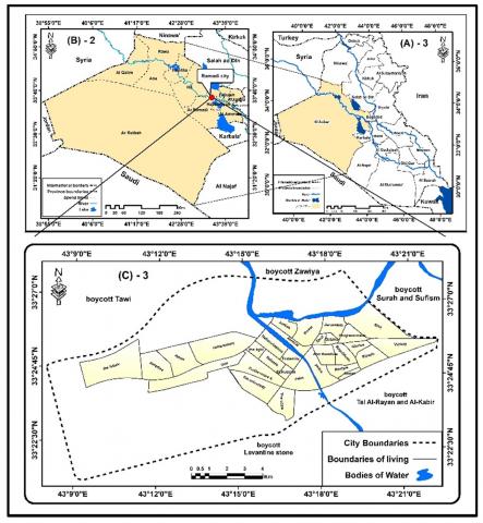
The study area is the city of Ramadi within the boundaries of the master plan; it covers an area of 15,272 hectares, located in Al-Anbar Governorate in western Iraq (Figure 1).
Figure 1. Location of Ramadi City in Iraq and Al-Anbar Governorate
Source: Prepared by the researcher using ArcGIS software, based on data from the Ministry of Water Resources, General Commission for Survey; the 1:1,000,000 scale topographic map of Iraq and the 1:500,000 scale map of Al-Anbar Governorate (2012); and the Urban Planning Unit in Al-Anbar Governorate. The source also includes the development and update of the master plan up to the year 2033, as well as Map No. 6327 at a scale of 1:25,000 from 2013.
A simple formula for residential unit density per hectare based on planning standards is:
48 residential units/hectare, with each unit averaging 200 m², and an average household size of 6 persons (typical Iraqi family size). This yields approximately 300 persons/hectare, which is high compared to the general city average of 46.4 persons/hectare over the total urbanized area of 5,861 hectares, and 17 persons/hectare considering the entire city area of 15,217 hectares. This discrepancy indicates large unbuilt or unusable spaces such as water bodies, private land, restricted areas, and deserts [5].
Table 1. General and gross population density of Ramadi City Neighborhoods, 2022
|
No. |
Neighborhood |
Area (hectares) |
% of Total Area |
Population |
% of Total Population |
Gross Density (persons/hectare) |
|
1 |
Al-Muallimeen |
133 |
2.27 |
13,133 |
4.8 |
98.7 |
|
2 |
Al-Shuhadaa |
87 |
1.48 |
12,691 |
4.7 |
154.9 |
|
3 |
Al-Salam |
143 |
2.44 |
9,600 |
3.5 |
67.1 |
|
4 |
Al-Jumhuri |
115 |
1.96 |
22,357 |
8.2 |
194.4 |
|
5 |
Al-Amjad |
58 |
0.99 |
11,340 |
4.2 |
195.5 |
|
6 |
Al-Warar |
82 |
1.40 |
4,867 |
1.8 |
59.4 |
|
7 |
Al-Riyadh |
85 |
1.45 |
12,740 |
4.7 |
149.9 |
|
8 |
Al-Ijtima’i |
27 |
0.46 |
4,396 |
1.3 |
129.5 |
|
9 |
Al-Ikhaa |
75 |
1.28 |
2,564 |
1.9 |
70.2 |
|
10 |
Al-Shafi’i |
74 |
1.26 |
8,122 |
3.0 |
109.8 |
|
11 |
Al-Ta’ayush |
49 |
0.84 |
6,345 |
3.2 |
129.5 |
|
12 |
Al-Hussein |
35 |
0.60 |
4,858 |
1.8 |
138.8 |
|
13 |
Al-Nakheel |
176 |
3.00 |
8,663 |
3.2 |
49.2 |
|
14 |
Al-Tahrir |
97 |
1.66 |
11,412 |
4.2 |
117.6 |
|
15 |
Al-Noor |
50 |
0.85 |
9,830 |
3.6 |
196.6 |
|
16 |
Al-Wihda |
235 |
4.01 |
4,249 |
1.6 |
18.1 |
|
17 |
Al-Zuhour |
144 |
2.46 |
14,670 |
5.4 |
101.9 |
|
18 |
Al-Aziziyah |
31 |
0.53 |
5,243 |
1.9 |
169.1 |
|
19 |
Al-Qattana |
38 |
0.65 |
3,540 |
1.3 |
93.2 |
|
20 |
Al-Adl |
86 |
1.47 |
6,872 |
2.5 |
79.9 |
|
21 |
Al-Quds |
82 |
1.40 |
10,379 |
3.8 |
126.6 |
|
22 |
Al-Taqaddum |
95 |
1.62 |
3,940 |
1.4 |
14.5 |
|
23 |
Al-Sahabah |
463 |
7.90 |
20,000 |
7.4 |
34.2 |
|
24 |
Al-Ameen |
236 |
4.03 |
6,055 |
2.2 |
25.7 |
|
25 |
Al-Waha |
185 |
3.16 |
1,700 |
2.6 |
38.6 |
|
26 |
Al-Jami’a |
182 |
3.11 |
1,205 |
0.4 |
6.6 |
|
27 |
Al-Nasr |
214 |
3.65 |
11,355 |
4.2 |
53.1 |
|
28 |
Al-Firdous |
226 |
3.86 |
2,857 |
1.1 |
12.6 |
|
29 |
Al-Mustaqbal |
497 |
8.48 |
11,095 |
4.1 |
22.3 |
|
30 |
Al-Sufiyah 1 |
252 |
4.29 |
9,549 |
3.5 |
37.9 |
|
31 |
Al-Sufiyah 2 |
107 |
1.83 |
1,938 |
0.7 |
18.1 |
|
32 |
Al-Ula |
226 |
3.86 |
1,322 |
0.5 |
5.8 |
|
33 |
Al-Bu Dhiab |
537 |
9.16 |
3,930 |
1.4 |
7.3 |
|
34 |
Al-Bu Faraj |
739 |
12.61 |
2,623 |
1.0 |
3.6 |
|
Total |
5,861 |
100.00 |
271,749 |
100.00 |
46.4 |
Sources: 1). Ministry of Planning, Central Statistical Organization, Anbar Statistics Directorate, Unpublished data, 2024. 2). Ministry of Municipalities and Public Works, General Directorate of Planning and Urban Development, Updated Master Plan (2013–2033), Map No. 6327J, 2013.
Table 2. Building materials by neighborhood
|
Neighborhood |
Brick (Freq) |
Brick (%) |
Block (Freq) |
Block (%) |
Stone (Freq) |
Stone (%) |
Cement (Freq) |
Cement (%) |
|
Thalatheen Tamuz |
5 |
62.50 |
1 |
12.50 |
2 |
25.00 |
|
|
|
5 KM |
1 |
7.14 |
4 |
28.57 |
9 |
64.29 |
|
|
|
Thananiya Shubat |
1 |
16.67 |
1 |
16.67 |
4 |
66.67 |
|
|
|
Al-Andalus |
0 |
33.33 |
2 |
33.33 |
2 |
33.33 |
|
|
|
Al-Taqaddum |
2 |
57.14 |
0 |
0.00 |
3 |
42.86 |
|
|
|
Al-Jam’iya |
4 |
33.33 |
1 |
16.67 |
3 |
50.00 |
|
|
|
Al-Jumhuri |
2 |
33.33 |
1 |
16.67 |
3 |
50.00 |
|
|
|
Al-Khansa |
2 |
16.67 |
4 |
66.67 |
1 |
16.67 |
|
|
|
Al-Shurta |
1 |
16.67 |
3 |
50.00 |
2 |
33.33 |
|
|
|
Al-Shirka |
1 |
28.57 |
0 |
0.00 |
5 |
71.43 |
|
|
|
Al-Sufiya |
2 |
57.14 |
1 |
14.29 |
2 |
28.57 |
|
|
|
Al-Aziziya |
4 |
57.14 |
2 |
28.57 |
1 |
14.29 |
|
|
|
Al-Qadisiyya 1 |
4 |
40.00 |
3 |
30.00 |
3 |
30.00 |
|
|
|
Al-Qadisiyya 2 |
4 |
8.33 |
6 |
50.00 |
5 |
41.67 |
|
|
|
Al-Qattana |
1 |
66.67 |
1 |
16.67 |
1 |
16.67 |
|
|
|
Al-Muallemin |
4 |
57.14 |
2 |
28.57 |
1 |
14.29 |
|
|
|
Al-Malaab |
4 |
25.00 |
2 |
25.00 |
4 |
50.00 |
|
|
|
Al-Warar |
2 |
33.33 |
2 |
33.33 |
2 |
33.33 |
|
|
|
Umm Ammar |
1 |
11.11 |
4 |
44.44 |
4 |
44.44 |
|
|
|
Jami’ Al-Warith |
1 |
16.67 |
3 |
50.00 |
2 |
33.33 |
|
|
|
Al-Akrad |
7 |
87.50 |
1 |
12.50 |
0 |
0.00 |
|
|
|
Al-Hawz |
19 |
100.00 |
0 |
0.00 |
0 |
0.00 |
|
|
|
Al-Dawajin |
4 |
40.00 |
3 |
30.00 |
3 |
30.00 |
|
|
|
Al-Zira’a |
8 |
100.00 |
0 |
0.00 |
0 |
0.00 |
|
|
|
Al-Dhubbat |
13 |
100.00 |
0 |
0.00 |
0 |
0.00 |
|
|
|
Al-Adl |
6 |
100.00 |
0 |
0.00 |
0 |
0.00 |
|
|
|
Omar Street |
6 |
85.71 |
0 |
0.00 |
1 |
14.29 |
|
|
|
Corniche Al-Ta’mim |
1 |
16.67 |
1 |
16.67 |
4 |
66.67 |
|
|
Source: Researcher’s work based on Questionnaire (1)
Second: Morphological effects
This includes both positive and negative impacts on the skyline, housing morphology, existing spaces, coverage ratios, and designs. The effects of fragmentation and subdivision on various morphological elements of Ramadi are diverse and include [6]:
Urban Effects: These effects significantly influence the fragmentation phenomenon. Economic, social, planning factors, and public interest considerations drive this process, leaving important impacts on the urban landscape. This section focuses on urban effects manifested through building form changes, such as building materials, architectural style, modifications, vertical extensions, skyline, coverage ratio, and available spaces [7].
Ramadi and the studied neighborhoods have witnessed a notable morphological transformation with the emergence of multi-story buildings exceeding two floors, which represents approximately 66% of the sample. There is also a shift to durable modern materials such as Halal stone, marble, and carved stone, in addition to traditional materials like brick, limestone, and cement used for foundations, walls, and roofs (see Table 2) [8].
This table indicates a significant change in many residential facades, their expansion trends, street frontage, and changes in residential systems, including the use of modern decorations and carvings in building designs. Residential plot areas have shrunk and divided into two or three parts after previously exceeding 500 m², especially in newer houses. This has likely contributed to urban fabric density, with buildings clustered tightly and open spaces sometimes eliminated, resulting in coverage rates reaching 100%. The questionnaire confirmed that 87% of surveyed fragmented residential units lack gardens and about 84% lack private garages, significantly affecting the exploitable spaces that serve urban residents' comfort [9].
This phenomenon also caused competition for space maximization, leading to the rise of apartment units. The researcher observed fragmentation into four two-story residential units sharing a central staircase. Most newer homes use colors, materials, and designs different from older houses, causing a visible disparity between modern and traditional residential units [10].
Commercial uses began encroaching on residential areas, leading to major urban changes such as the emergence of malls and commercial buildings adjacent to residential units. These mainly appeared along primary and arterial streets in the study area, such as Al-Mustawda’ Street, 20th Street, Fakrah Street, Al-Salam neighborhood, Al-Dhubbat, Omar Street, and the road linking the old housing area to Al-Riyadh neighborhood. New building materials and facade decorations, such as carbon, display screens, and commercial signs appeared. The city skyline on these streets rose to over 24 meters, especially on Al-Mustawda’, Fakrah, and 20th Streets. This has impacted the study area’s character, strengthened its urban fabric, and increased building interpenetration. Commercial use, with its capacity to pay higher rents and possibly higher land prices, has driven vertical expansion to maximize spatial units [11].
5.1 Effects on public buildings and city morphology
Fragmentation led to varied building designs and expansion in both service buildings and industrial workshops. Increased land use density due to subdivision or construction likely increased population density, raising demands for services either by renovating old structures or establishing new service institutions, often with multi-story designs such as schools, mosques, and health centers. Modern materials such as ceramic, marble, Halal stone, and carbon influenced building appearances, causing external changes in the study area [12].
5.1.1 Residential unit occupancy density
Occupancy density can be assessed through variables like the number of household members and the number of rooms actually occupied. Based on the survey, the average household size in Ramadi is over six persons, accounting for 70.3% of households [13]; those with fewer than six persons constitute 29.7% (see Table 3).
Table 3. Average number of rooms and their area per residential unit by Ramadi Neighborhood, 2022
|
Ref. |
Neighborhood |
Number of Rooms (1) |
Population % |
Avg. Room Area (m²) (2) |
Avg. Rooms/Unit (3) |
Avg. Persons/Room (1) |
|
1 |
Al-Muallimeen |
6465 |
5.5 |
20 |
2.93 |
2.0 |
|
2 |
Al-Shuhada |
4756 |
4.0 |
20 |
4.53 |
2.7 |
|
3 |
Al-Salam |
4934 |
4.2 |
25 |
1.98 |
1.9 |
|
4 |
Al-Jumhouri |
6900 |
5.9 |
24 |
1.98 |
3.2 |
|
5 |
Al-Amjad |
5360 |
4.6 |
20 |
2.48 |
2.1 |
|
6 |
Al-Warar |
4280 |
3.6 |
25 |
3.93 |
1.1 |
|
7 |
Al-Riyadh |
3571 |
3.0 |
20 |
1.13 |
3.6 |
|
8 |
Al-Ijtimai |
3248 |
2.8 |
20 |
4.57 |
1.1 |
|
9 |
Al-Ikhaa |
2445 |
2.1 |
22 |
2.86 |
2.2 |
|
10 |
Al-Shafei |
1641 |
1.4 |
20 |
1.71 |
4.9 |
|
11 |
Al-Ta'ayush |
1966 |
1.7 |
20 |
2.30 |
3.2 |
|
12 |
Al-Hussain |
3223 |
2.7 |
20 |
4.19 |
1.5 |
|
13 |
Al-Nakheel |
5587 |
4.8 |
20 |
2.01 |
1.6 |
|
14 |
Al-Tahrir |
4498 |
3.8 |
24 |
1.81 |
2.5 |
|
15 |
Al-Noor |
3725 |
3.2 |
20 |
2.97 |
2.6 |
|
16 |
Al-Wahda |
1735 |
1.5 |
20 |
1.34 |
2.4 |
|
17 |
Al-Zuhur |
6240 |
5.3 |
20 |
1.98 |
2.4 |
|
18 |
Al-Aziziyah |
2940 |
2.5 |
20 |
2.98 |
1.8 |
|
19 |
Al-Qattana |
1929 |
1.6 |
20 |
1.01 |
1.8 |
|
20 |
Al-Adl |
3229 |
2.7 |
20 |
3.24 |
2.1 |
|
21 |
Al-Quds |
5652 |
4.8 |
20 |
2.98 |
1.8 |
|
22 |
Al-Taqaddum |
3261 |
2.8 |
24 |
2.97 |
1.2 |
|
23 |
Al-Sahabah |
6267 |
5.3 |
20 |
2.98 |
3.2 |
|
24 |
Al-Amin |
2700 |
2.3 |
20 |
2.87 |
2.2 |
|
25 |
Al-Waha |
1200 |
1.0 |
20 |
1.85 |
5.9 |
|
26 |
Al-Jami'a |
567 |
0.5 |
16 |
0.73 |
2.1 |
|
27 |
Al-Nasr |
3528 |
3.0 |
20 |
2.93 |
3.2 |
|
28 |
Al-Firdaws |
2142 |
1.8 |
20 |
2.86 |
1.3 |
|
29 |
Al-Mustaqbal |
2250 |
1.9 |
20 |
2.39 |
4.9 |
|
30 |
Al-Sufiyya 1 |
5201 |
4.4 |
25 |
3.66 |
2.2 |
|
31 |
Al-Sufiyya 2 |
1060 |
0.9 |
24 |
0.97 |
1.1 |
|
32 |
Al-Ula |
175 |
0.1 |
20 |
0.65 |
7.6 |
|
33 |
Al-Bu Dhiab |
2884 |
2.5 |
25 |
2.77 |
1.1 |
|
34 |
Al-Bu Faraj |
2031 |
1.7 |
25 |
1.48 |
1.1 |
|
- |
Average Ramadi City |
3459 |
2.9 |
21 |
2.75 |
2.5 |
Source: Survey, Appendix 1
The overall average number of rooms in the study area reached about 3,459, with an average room size of 200 m². The average number of rooms per unit is approximately 2.7, with crowding rates at 2.5 persons/room citywide. These statistics vary across neighborhoods, with the highest room count in Al-Jumhuri neighborhood (6,900 rooms, avg. room size 24 m²). Other neighborhoods like Al-Andalus, Al-Muallemin, Othman Bin Affan, and Al-Sahaba follow with around 5.5% and 5.3% of the total, and average room sizes of 20 m². These figures align well with the planning standard of 12-15 m² per room [14].
The average number of rooms per household is approximately 2.7, varying by neighborhood. For example, Al-Aramel, Al-Ijtima’i and Muhammad Al-Mazloom neighborhoods each have about 4.5 rooms per household, whereas Al-Sufiya Second records the lowest at one room per unit. These figures are influenced by the economic status of residents, plot size, and building floors. The planning standard considers 2 rooms per unit adequate. Crowding is also an important indicator, with an average of 2.5 persons per room, reflecting socio-economic and cultural comfort levels [15].
5.1.2 Pressure on services
Cities differ from rural areas by the availability of various services, whether community or infrastructure services. These services are a necessity for any human settlement and their distribution throughout the city, in terms of quantity and quality, follows planning and regulatory standards set by urban administrations to control growth or achieve sustainable development. These standards vary temporally and spatially.
Population or housing increases affect the number and distribution of service institutions, increasing pressure on them and impacting their efficiency and adequacy. The potential impact of fragmentation and subdivision on services is as follows:
Community services includes health, education, and recreation services that require movement toward them.
Education is a fundamental pillar of societal progress and a measure of its advancement or backwardness. The availability of schools, scientific, technical, and professional staff contributes to building the society economically, socially, politically, and technologically. Development begins with education as the foundation of progress.
Educational services planning follows general standards such as spatial requirements for different levels: primary schools require no less than 6,000 m², secondary schools 9,000–11,000 m², and intermediate schools 8,000 m². Standards correlate school numbers with population sizes: one primary school per 2,000–4,000 inhabitants, one intermediate school per 5,000–15,000 inhabitants, and one secondary school per 18,000–70,000 inhabitants.
Therefore, there is typically a primary school per neighborhood, an intermediate school per residential district, and one or more secondary schools covering multiple districts.
The consequences of increased population density on education include:
Applying planning standards (250 students per school) reveals:
Includes water, electricity, sanitation, solid waste collection, roads, and telecommunications. These services extend linearly throughout the city, ensuring availability to all residents. Service availability depends on per capita shares based on planning standards and represents a critical aspect of modern urban development and technological progress. This section examines fragmentation’s impact on water, electricity, and sanitation services in Ramadi [17].
Water is vital for all living beings, with usage nearly doubling during the 20th century's population increases. Increasing demand and deteriorating water quality pose serious risks, aggravated by climate change. Many urban residents suffer from a lack of clean drinking water. As cities develop functionally and population grows, water services expand, being an essential and continuously increasing need. Ramadi’s main water source is the Euphrates River, alongside which several water projects supply parts of the city. The first drinking water project, currently called the Justice Palace Complex, delivers water via a main pipeline from Al-Warar Street to Al-Muallemin neighborhood, Cinema Street, and the Post Office. Due to population growth and new neighborhoods, the project's capacity was expanded to 500 m³/hour, along with the New Ramadi Warehouse project of similar capacity, together supplying 74.7% of the city’s drinking water needs. After the early 1980s, vertical tanks were built such as the warehouse tank, 20th Street tank, and the Water and Sewage Department tank near Sheikh Abdul Jalil Mosque on the main street. These tanks are currently out of service due to a connection with the old network.
In 1983, a water-pumping project was established by an Indian company, with a design capacity of 300 cubic meters per hour. However, due to the city's expansion, the growing population, and the resulting shortage in water supply, additional projects were initiated—most notably, the Greater Ramadi Project located in the Al-Warar area, which has a design capacity of approximately 6,000 cubic meters per hour. This project currently provides about 75% of the city’s water supply water services cover nearly 100% of the city, except for some neighborhoods, especially newer and remote areas away from main pumping stations. Coverage varies temporally and spatially, affected by pipe distribution, pipe age, treatment methods, and pumping techniques [18].
The city is likened to a living organism that consumes food and water and expels waste. The method of safe waste disposal is as important as its provision.
Ramadi was equipped early on with a sewage network, primarily designed for rainwater drainage, not heavy wastewater. The old sanitation network, still operating in some neighborhoods like Al-Taqaddum and Al-Quds, is partly out of service due to being beyond its lifespan and due to illegal defects causing blockages and pipe corrosion.
Many neighborhoods lack proper sewage coverage. Wastewater is often disposed into settling ponds (especially for heavy wastewater), while other liquid wastes and rainwater flow into open drains or pools, causing urban residents’ discomfort and becoming breeding grounds for pests.
According to standards from related agencies in Ramadi, the per capita water share is 360 liters/day for an average family size of 7 persons. Based on the city’s population of 271,749, total water demand equals approximately 97,829,640 liters/day, distributed according to population size, proximity to water projects, and pipe conditions. This consumption varies annually based on water reserves and climatic conditions [19].
Comparing this to a 67% allocated water share per person results in approximately 66 million liters, roughly the city’s daily liquid waste output. The current disposal system uses stormwater and sewage pipes and open drains, often discharging into the Euphrates and Al-Warar rivers untreated, causing serious environmental damage affecting urban residents and waterfront areas, which are vital recreational spaces. Observations note declining water quality, color changes, and increased pollutant levels.
The degree of residents’ satisfaction with sanitation varies by neighborhood, with coverage rates not exceeding 70% in neighborhoods like Al-Muallemin, Al-Shuhada, Al-Adl, and Al-Aziziya, dropping below 30% in Al-Amin and others, primarily due to their recent development [20].
Table 4. Number of schools, students, buildings, and classes (Al-Anbar Directorate of education)
|
Stage |
Boys |
Girls |
Mixed |
Total Schools |
Boys Students |
Girls Students |
Total Students |
Buildings |
Classes |
|
Kindergarten |
0 |
0 |
5 |
5 |
602 |
608 |
1210 |
5 |
18 |
|
Primary |
135 |
117 |
52 |
304 |
54,206 |
49,041 |
103,220 |
182 |
3148 |
|
Intermediate |
47 |
21 |
4 |
72 |
13,480 |
4,148 |
17,628 |
31 |
471 |
|
Preparatory |
19 |
7 |
0 |
26 |
6,594 |
3,333 |
9,927 |
11 |
459 |
|
Secondary |
20 |
50 |
6 |
76 |
6,893 |
17,332 |
24,225 |
41 |
950 |
|
Secondary Total |
86 |
78 |
10 |
174 |
26,967 |
24,813 |
51,780 |
83 |
1916 |
|
Vocational |
2 |
2 |
2 |
6 |
2,966 |
563 |
3,529 |
4 |
100 |
|
Institutes |
1 |
1 |
0 |
2 |
228 |
46 |
274 |
2 |
13 |
|
Total |
224 |
198 |
69 |
491 |
84,969 |
65,071 |
150,040 |
276 |
5195 |
Source: Al-Anbar Directorate of Education, Statistics Department, Unpublished data, 2024
6.1 Recommendations
Appendix (1): Questionnaire Form
|
Republic of Iraq Ministry of Higher Education and Scientific Research University of Anbar / College of Education for Humanities Department of Geography |
Subject: Questionnaire Form
The information provided below is intended solely for academic research purposes related to the master's thesis titled:
"The Consequences of the Fragmentation and Division of Housing Units: A Case Study of Ramadi City, Iraq."
We kindly request your accurate and objective responses to the following items to help complete the research. With sincere appreciation.
Questionnaire
1. Name ofs the Neighborhood: _______________________________
2. Occupation of Head of Household:
⃞ Daily wage earner ⃞ Unemployed ⃞ Self-employed
3. Number of Families Living in the Dwelling:
⃞ One family ⃞ Two families ⃞ More than two families
4. Date of Residence in the Dwelling: ____________
Date of Construction: ____________
5. Number of Residents in the Dwelling: ___________
6. Type of Housing Unit:
⃞ Old House ⃞ New House ⃞ Apartment
7. Age of the Dwelling:
⃞ 1–9 years ⃞ 10–19 years ⃞ 20–29 years ⃞ 30–39 years
8. Construction Material Used in the House:
⃞ Fired Brick ⃞ Concrete Block ⃞ Stone ⃞ Cement
⃞ Mud
9. Roofing Material:
⃞ Reinforced Concrete ⃞ Sheet Metal (Shilman) ⃞ Wood
⃞ Other (please specify): ____________
10. Area:
Total Land Area (m²): ____________
Total Built-up Area (m²): ____________
11. Number of Floors:
⃞ One Floor ⃞ Two Floors ⃞ More than Two Floors
12. Spaces Available in the House and Their Area (if applicable):
⃞ Garden(s): ____________ ⃞ Garage(s): ____________
⃞ Storage Room(s): ____________
13. Has the house you live in undergone fragmentation or subdivision?
⃞ Yes. If yes, specify the reason: __________________________
⃞ No
[1] Ramel, K.A., Mehemdi, Y.H.A., Awad, A.Y. (2024). Analysis of the trends of change in temperature and precipitation and their impact on water in Anbar Governorate (1980-2023). Dirasat: Human and Social Sciences, 51(5): 16-32. https://doi.org/10.35516/hum.v51i5.10019
[2] Al-Hiti, M.A.R. (2013). Geography of Services, Foundations and Concepts. Arab Society Library for Publishing and Distribution, Amman, Jordan.
[3] Al-Dulaimi, K. (2009). Planning Community Services and Infrastructure: Foundations Standards Techniques. Dar Safaa for Publishing and Distribution, Amman.
[4] Sayel, J.J., Khalaf, A.M., Al-Bayati, A.H.I. (2025). Spatial distribution of some soil characteristics of Ramadi district, western Iraq. International Journal of Environmental Impacts, 8(1): 103-111. https://doi.org/10.18280/ijei.080111
[5] Hammad, L., Abd Al-Hussein, Q., Ghadeeb, M.A. (2020). Geographical analysis of the phenomenon of functional and urban change in the Andalus and teachers neighborhoods within the city of Ramadi. Dirasat: Human and Social Sciences, 47(2): 322-343.
[6] Ghadeeb, M. (2020). The planning problems and defects that accompanied the development of the basic plans for the city of Ramadi. Dirasat: Human and Social Sciences, 47(2): 4004-418.
[7] Ali, M.M., Al-Kodmany, K. (2012). Tall buildings and urban habitat of the 21st century: A global perspective. Buildings, 2: 384-423. https://doi.org/10.3390/buildings2040384
[8] Al-Hardani, A.M.A.A. (2016). Geographical analysis of the efficiency of infrastructure services in Anbar Governorate. Unpublished PhD thesis, College of Education for Humanities, University of Anbar.
[9] Wahiba, A.F. (1992). Geography of Urbanization. Beirut.
[10] Ramadi Water Directorate. (2024). Planning and Follow-up Department. Unpublished data for the year 2024.
[11] Al-Dhiabi, Y.M.J. (2018). The functional efficiency of infrastructure services in the City of Ramadi. Unpublished Master’s Thesis, Department of Geography, College of Arts, University of Anbar.
[12] Salem, H.S. (2021). Evaluation of the stone and marble industry in Palestine: Environmental, geological, health, socioeconomic, cultural, and legal perspectives, in view of sustainable development. Environmental Science and Pollution Research, 28: 28058-28080. https://doi.org/10.1007/s11356-021-12526-4
[13] Mushref, Z.J., abd, A.H.W., Mikhlif, A.M., Abed, S.O. (2022). A cartographic representation of the characteristics of Al-Rutba district population. International Journal of Design & Nature and Ecodynamics, 17(4): 621-626. https://doi.org/10.18280/ijdne.170418
[14] Al-Fahdawi, A.H.A., Satam, A.T.M. (2022). A study of the water reality of managing the Euphrates river in Anbar governorate in light of the growing water demand for the period (2020-2040). AIP Conference Proceedings, 2400(1): 040004. https://doi.org/10.1063/5.0125471
[15] Satam, A.T.M., Aldulaimi, A.M.K., Mushref, Z.J. (2022). Assessment of the water environment of the Euphrates River in the District of Fallujah. AIP Conference Proceedings, 2400(1): 040005. https://doi.org/10.1063/5.0112622
[16] Satam, A.T.M., Mekhlef, S.A., Mushref, Z.J., Sulaiman, S.O. (2024). Sustainable management strategies of the water pollution of the Euphrates River within Ramadi City west of Iraq. International Journal of Sustainable Development and Planning, 19(9): 3587-3593. https://doi.org/10.18280/ijsdp.190926
[17] Satam, A.T.M., Mukhlef, W.H., Razzaq, A.S.A.A., Mushref, Z.J., Sulaiman, S.O. (2025). Spatial and temporal variations in water quality of the Euphrates River: A sustainable water management approach for Anbar Governorate, Iraq. International Journal of Design & Nature and Ecodynamics, 20(1): 99-106. https://doi.org/10.18280/ijdne.200111
[18] Saleh, A.A., Al-Mohammadi, A.R.M.J. (2023). A spatial analysis of educational services in the city of Fallujah for the period from the beginning of the twentieth century until the establishment of the Republic. AIP Conference Proceedings, 2793: 060017. https://doi.org/10.1063/5.0164807
[19] Ali, B.B., Globe, L.R., Salh, A.M. (2025). Analyzing directional urban sprawl from 1978 to 2023 using Shannon entropy analysis on Landsat imagery: A case study in Ramadi City, Iraq. International Journal of Geoinformatics, 21(3): 62-70. https://doi.org/10.52939/ijg.v21i3.3995
[20] Mohammed, K.S., Al-lahaibi, A.F.F., Abdullah, K.A. (2024). Evaluating temporal variations in soil deterioration in Iraq’s karma district using spectral indicators. Anbar Journal of Agricultural Sciences, 22(2): 1397-1410. https://doi.org/10.32649/ajas.2024.184878