Sarika K. Dharangaonkar*![]() | Sonali A. Patil
| Sonali A. Patil![]()
© 2025 The authors. This article is published by IIETA and is licensed under the CC BY 4.0 license (http://creativecommons.org/licenses/by/4.0/).
OPEN ACCESS
The widespread adoption of Electric Vehicles (EVs) has intensified the need for efficient and scalable Electric Vehicle Charging Infrastructure (EVCI). A critical aspect of this development is the optimal siting of charging stations, which involves complex multi-criteria decision-making based on spatial, economic, technical, and behavioral factors. This paper presents a comprehensive Systematic Literature Review on location analysis for EVCI planning, synthesizing findings from 91 peer-reviewed studies published between 2011 and 2024. We categorize and evaluate existing methodologies ranging from mathematical optimization models to Geographical Information System (GIS)-based and machine learning techniques and develop a comparative framework highlighting their strengths, limitations, and applicable contexts. In addition, we propose a unified taxonomy of influencing factors and a structured classification of decision-support approaches. Beyond summarization, the study identifies critical research gaps such as underexplored rural deployment models, limited real-time data integration, and inconsistent treatment of user behavior. To bridge these gaps, we suggest a hybrid GIS-Machine Learning (ML) conceptual framework and offer insights for future work aimed at scalable and equitable EVCI deployment. The outcomes provide urban planners, policymakers, and researchers with a roadmap for technically sound and sustainable infrastructure planning.
electric vehicle (EV), charging station, infrastructure planning, site selection, urban planning, sustainability
The global shift towards sustainable transportation has accelerated the adoption of Electric Vehicles (EVs). As EV adoption increases, the demand for charging infrastructure is also increasing. The appropriate location of charging stations is essential for their effective utilization and the overall success of EV adoption. Location analysis is done by evaluating and selecting optimal sites for charging stations based on technical, economic, environmental, and social criteria. Despite its importance, the methodologies and factors involved are diverse and advancing.
The strategically locating EV charging stations is important for a number of reasons. Firstly, it ensures accessibility and convenience for EV owners, encouraging wider adoption of EVs by alleviating concerns about range anxiety. Placing charging stations in urban areas, along highways, and at key destinations such as shopping centers or workplaces gives seamless integration of EVs, which will be helpful into daily routines and long-distance travel. Moreover, strategic planning of charging stations can help to optimize the use of existing infrastructure and resources. By placing stations in areas with high traffic or where drivers are likely to spend time, such as near public transit hubs or popular attractions areas. With this, the usage of charging infrastructure can be maximized which will lead to more efficient operation and reduced wait times for users. This study presents a review that not only synthesizes 91 peer-reviewed articles published between 2011 and 2024 but also proposes a hybrid conceptual framework integrating GIS, Multicriteria Decision Making (MCDM), and ML approaches for improved site selection. We systematically classify methodologies, compare them based on technical criteria, and highlight key influencing factors and implementation challenges. In addition, we perform a comparative analysis of modeling techniques and suggest actionable future research directions. By bridging the methodological and application gaps in current literature, this review aims to serve as a foundational guide for researchers, urban planners, and policymakers working towards scalable and sustainable EVCI deployment.
2.1 Systematic review strategy
This systematic literature review aims to explore the methodologies, decision-making frameworks, and challenges involved in the location analysis of EVCI. The review synthesizes the research published over the past two decades, covering different geographical regions, charging technology advancements, and application areas. The review seeks to provide insights into the current state of knowledge, highlight research gaps, and offer recommendations for future studies in the field of EVCI planning. This study aims to review the literature on EVCI site selection methodologies and attempts to answer the research questions shown in Figure 1.
Figure 1. Research questions for systematic literature review
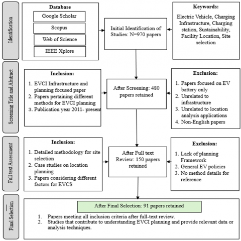
Systematic literature review was conducted using a four-step approach, The process involves formulating review questions, identifying relevant literature based on inclusion and exclusion criteria, selecting studies for review, extracting and analysing data, and interpreting the results for dissemination. To address the research questions, we searched several databases for research published between 2011 and 2024 related to the EVCI location problem. Following a thorough evaluation of the models used in each study, as well as the methods for selecting variables and ranking alternative locations, we selected 96 papers for inclusion. The steps to carry out this review comprise of identification, screening of titles and abstracts, full-text assessment, and final selection as given in Figure 2.
Figure 2. Systematic literature review block diagram
2.2 Review of findings
The findings are analyzed based on various factors, including identifying common methodologies used for location analysis in EVCI, comparing different approaches for site selection, and examining the factors that influence charging station location. The review also explores the strengths and weaknesses of each method. The table of literature review summarizes the key studies on EVCI planning, providing an overview of the approaches and findings from different research efforts.
2.2.1 Publication trends of location analysis for EVCI
Figure 3 illustrates the year-wise distribution of the selected research papers for this systematic literature review, showing that most of the research was conducted in 2023 and 2024. Additionally, as shown in Figure 4, 14% of the selected papers are conference papers, while 86% are journal papers. Figure 5 provides an analysis of the keywords from the selected papers. The detail analysis of the papers used for this review is given in Table 1.
Figure 3. Year wise distribution of research publications
Figure 4. Research publications
Figure 5. Keywords analysis
2.2.2 Most used model for location analysis
The detailed explanations for each specific application of these models or methods were streamlined to provide concise descriptions with fully encompassing all reviewed material. Future researchers can infer an appropriate model-method combination by assessing the available data, processing capabilities, and their chosen optimization strategy, such as maximizing profits or minimizing service distances.
Most of the reviewed studies predominantly employed GIS-based MCDM models with various methods for location and criteria processing, while approximately one-third integrated location selection models with GIS-based MCDM models. Figure 6 and Figure 7 illustrate the frequency of usage of standalone GIS models and combined approaches. A comprehensive categorization of these modelling techniques, along with their frequency of use in the reviewed studies and a list of corresponding research papers, is provided in Table 2. A Mixed-Integrated Linear Programming (MILP) model was utilized to determine the optimal locations and sizes of charging stations, aiming to maximize overall profits while adhering to five key constraints [1]. GIS was incorporated to process critical geographical parameters within the MILP framework. Similarly, the problem was formulated as a Mixed-Integer Non-Linear Programming (MINLP) model, which was solved using a genetic algorithm [2].
Set covering models (SCM), including the Set Cover Problem (SCP), Maximal Covering Location Problem (MCLP), and Location Set Covering Problem (LSCP), are designed to address coverage objectives for elements within a set. These approaches are classified into three categories: maximum coverage, p-center, and p-median problems. The maximum coverage problem focuses on maximizing demand coverage for a specified number of EVCI, the p-center problem minimizes driving distance with a fixed number of stations, and the p-median problem uses the median driving range as a key metric and employed a MCLP to identify the optimal number and locations of charging stations, ensuring that no EV demand point exceeds the maximum service distance [3]. It is also noted that the MCLP is NP-hard and can be addressed using techniques such as linear programming relaxation, greedy-adding heuristics, genetic algorithms, and heuristic concentration. Multi objective optimization approach is also used for finding parking lots suitable for charging [4]. A Three-Step Heuristic Approach is introduced to the Electric Vehicle Path Planning Problem considering Charging availability [5, 6]. Geographical information system is the most widely used method for location analysis along with MCDM for site selection problem.
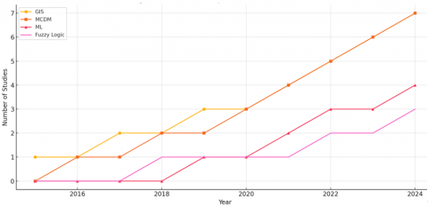
From Figure 8, GIS and MCDM techniques dominate the literature, while machine learning approaches are gaining momentum. Figure 6 presents a timeline of methodological adoption from 2015 to 2024, showing a steady rise in the use of MCDM and a more recent increase in machine learning applications, highlighting a shift toward data-driven decision-making frameworks.
Figure 6. Method Adoption Trend (2015-24). This timeline illustrates the rise in adoption of spatial, decision-support, and predictive methods for EVCI planning over the past decade. The chart is derived from a longitudinal review of selected publications [1, 7-25]
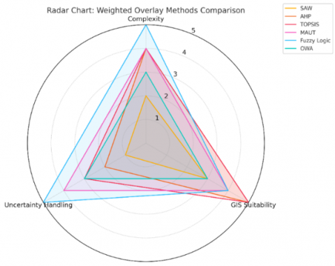
Figure 7. Radar chart for weighted overlay analysis methods comparison. The comparison highlights differences in complexity, suitability for GIS-based integration, and ability to handle uncertainty. Methodologies are synthesized from multiple sources [1, 7-25]
Figure 8. Method Usage Frequencies over reviewed literature. This bar chart summarizes the frequency with which different methodologies were applied in EV charging station site selection studies. Data synthesized from key references [1, 7-25]
2.2.3 Data processing methods that are most used for location analysis of EVCI
In the reviewed literature, various methodologies have been employed for data processing to optimize site selection for EVCI. A significant proportion of studies have utilized variants of the Weighted Overlay Analysis (WOA) approach, including but not limited to Simple Additive Weighting (SAW) [26, 27], Analytical Hierarchy Process (AHP), Weighted Sum Model (WSM), and Technique for Order Preference by Similarity to Ideal Solution (TOPSIS). These methodologies are adept at concurrently evaluating multiple variables and effectively incorporating the influence of qualitative or non-quantifiable factors on spatial parameters. A comprehensive overview of these methods is provided in Table 3. Numerous researchers have recommended conducting a comparative analysis of these WOA techniques to determine the approach that yields the most accurate and optimal results.
The AHP emerged as the second most frequently employed methodology in the reviewed research, with twelve out of seventy-four studies utilizing this technique or its fuzzy variant (FAHP). AHP operates through a hierarchical structure and assigns quantitative weights to decision criteria [28]. It involves pairwise comparisons conducted by experts to determine the relative importance of alternatives [7, 8].
This method is widely recognized for its ease of use and scalability across diverse problem domains. “AHP, developed under the framework of MCDM, comprises techniques suitable for ranking critical management problems,” employing the relative importance scale [25, 29, 30]. In this scale, attributes are assigned values from 1 to 9, where 1 represents negligible importance and 9 signifies the highest importance for the location of EVCI. While AHP facilitates straightforward comparisons by individual experts, it may encounter inconsistencies in criteria ranking, particularly when dealing with several alternatives. To address challenges related to imprecise and uncertain data, a fuzzy extension of AHP (FAHP) has been proposed. FAHP leverages linguistic variables, making it particularly effective for processing the inherent uncertainties in EVCS location research.
The TOPSIS is another widely utilized optimization method in GIS-based EVCI studies. Among all reviewed papers, nine applied this method or its fuzzy variant (Fuzzy TOPSIS). TOPSIS is employed to generate a reliable ranking of alternative EVCI sites by determining the site with the shortest distance to the positive ideal solution and the farthest distance from the negative ideal solution. Criterion values for the alternatives were derived from pixel values within the corresponding GIS criterion map layers. The rankings obtained through TOPSIS were then compared with those derived from pixel-based suitability indices established in their research, demonstrating the method's utility in evaluating spatial alternatives effectively [7, 20].
The Complex Proportional Assessment (COPRAS) method employs stepwise ranking and multi-attribute evaluation techniques for selecting alternative EVCI sites. A variation, FAHP-COPRAS, which incorporates fuzzy logic to address uncertainty and provides compromise solutions by evaluating the significance and degree of utility of alternatives. An extension of COPRAS, known as Fuzzy COPRAS, further enhances its ability to process ambiguous datasets [8].
Another notable method for optimal EVCI site selection is the Preference Ranking Organization Method for Enrichment of Evaluations (PROMETHEE). This approach supports decision-making by identifying congruencies and conflicts among alternatives, enabling a well-informed selection process [31]. PROMETHEE ranks EVCI site alternatives through binary comparisons of criteria, distinguishing itself from other MCDM methods by emphasizing the importance of relationships among criteria. Generally, used distance measure in those methods is Euclidean distance for considering road distances and further evaluation of the criteria [32, 33]. These internal relationships are determined by the dataset's distribution, adding a unique dimension to its evaluation process [34]. Multi-influencing factors (MIF) is also used in many studies with MCDM for different location analysis and site selection problems [35-38].
In addition to the methods mentioned, various other models, algorithms, heuristic techniques, and hybrid approaches are present in the reviewed literature and have been applied to address the site selection problem for EVCI. These methods integrate different strategies to optimize decision-making, leveraging a combination of analytical, computational, and heuristic processes to tackle the complexity of site selection under varying conditions. The radar graph in Figure 7 illustrates a comparative assessment of weighted overlay analysis methods across three dimensions: computational complexity, suitability for GIS integration, and capacity to handle uncertainty. Methods like AHP and TOPSIS scored high on GIS compatibility and decision robustness, while Fuzzy Logic stood out in handling imprecise data. This visualization helps highlight method suitability based on the analytical needs of EV infrastructure planning.
2.2.4 Factors/criteria influencing charging infrastructure location
Table 1 gives the different criteria for EVCI site selection, where distance from roads/ highways is considered as major criteria for charging infrastructure planning along with land cost, proximity to petrol stations, availability of power grid, etc.
Table 1. Criteria for EVCI planning
|
Sr. No. |
Criteria |
Reference |
|
1 |
Solar Radiation |
[1, 8, 39] |
|
2 |
Slope |
[1, 40-42] |
|
3 |
Aspect (south facing areas) |
[1] |
|
4 |
Traffic Volume |
[1, 43] |
|
5 |
Land Use/ Land Cover |
[1, 8] |
|
6 |
Distance from Highway, Roads |
[1, 6, 8, 40-42, 44] |
|
7 |
Population Density |
[6, 40, 41, 43, 44] |
|
8 |
Shopping malls |
[6, 40, 42] |
|
9 |
Land Values/cost |
[6, 40, 41, 43] |
|
10 |
Income Rates |
[40] |
|
11 |
Transportation Stations |
[6, 40] |
|
12 |
Petrol Stations |
[6, 40, 41, 44] |
|
13 |
Park Areas |
[6, 40, 44] |
|
14 |
Green Areas/vegetation |
[40, 44] |
|
15 |
Operating and management cost |
[6, 43] |
|
16 |
Consumption level |
[6] |
|
17 |
Construction Cost |
[6, 8, 43] |
|
18 |
Population Density |
[6, 43, 44] |
|
19 |
Generation of noise and air pollution |
[6] |
|
20 |
Reliability on Power |
[43] |
|
21 |
Availability of power station |
[8, 41, 43, 44] |
|
22 |
Air quality Index |
[43, 44] |
|
23 |
Land Availability |
[43] |
|
24 |
Distance to vegetation |
[41, 44] |
|
25 |
Distance to water bodies |
[7, 41, 44] |
|
26 |
Distance to landslide risk |
[41] |
|
27 |
Earthquake risk |
[41] |
|
28 |
EV ownership |
[41] |
|
29 |
Distance to another EVCS |
[41, 44] |
|
30 |
Gas station distribution |
[7, 44] |
|
31 |
Annual Average temperature |
[8] |
|
32 |
Possibility of power expansion |
[8] |
|
33 |
Proximity to commercial offices |
[44] |
|
34 |
Distance from bus/railway/metro/monorail stations |
[44] |
2.2.5 Challenges in the planning and implementation of EVCI
The planning and implementation of EVCI present a multitude of challenges spanning technological, economic, regulatory, and environmental dimensions [45, 46]. A significant barrier is the inadequacy of existing power grids [47] to handle the increased load from EV charging, necessitating substantial investments in grid modernization and capacity expansion [48, 49]. Additionally, the lack of standardization in charging protocols and connectors across manufacturers complicates interoperability [50], while the high initial costs of installation and equipment deter widespread deployment, especially in regions with low EV adoption. Land availability, particularly in urban areas, further exacerbates the issue, limiting the optimal placement of charging stations to ensure accessibility and high utilization [51, 52].
Regulatory and policy inconsistencies across regions impede uniform development, with lengthy permitting processes and high electricity tariffs adding to the complexity [8, 40]. Moreover, the environmental impact of charging stations powered by non-renewable energy diminishes the sustainability of EVs [53], highlighting the need for renewable integration [39, 54]. Operational challenges, including station reliability, real-time monitoring, and maintenance, further hinder scalability [55]. Addressing these challenges requires a multifaceted approach involving policy standardization, public-private partnerships, and investment in advanced technologies to ensure efficient, scalable, and environmentally sustainable EVCI deployment.
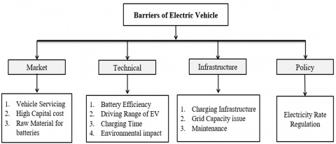
The adoption of EVs and the expansion of charging infrastructure face several barriers and challenges as given in Figure 9. High initial costs of EVs, limited battery range, and long charging times discourage potential buyers [56-58]. The lack of widespread charging stations, especially in rural areas, leads to range anxiety.
Figure 9. Barriers of EV
Existing power grids may struggle with increased demand, requiring significant upgrades. The cost of installing fast-charging stations is high, and standardization issues between different manufacturers create compatibility problems. Additionally, concerns over battery disposal, raw material sourcing (like lithium and cobalt) [59], and environmental impact pose sustainability challenges [60-62]. Overcoming these barriers requires coordinated efforts from governments, industries, and consumers to improve infrastructure, reduce costs, and advance battery technology [63, 64].
The detail analysis of the review is given in Table 2 which summarizes the methodologies employed for location analysis of EVCI, specifying their respective use cases, input parameters, and highlighting their advantages and limitations. These methods include optimization models, GIS-based approaches, and simulation techniques.
Table 3 provides a summary of the key elements involved in location analysis using Geographic Information Systems, including the relevant bands, wavelengths, and resolution necessary for effective analysis. It also highlights how these factors are applied in determining optimal locations for EVCI. The table offers insights into the role of GIS in enhancing the accuracy and efficiency of location analysis.
The reviewed literature highlights the use of GIS for spatial analysis, MCDM for structured decision-making, and ML for demand prediction in EV charging infrastructure planning. However, gaps remain as GIS approaches often overlook temporal and behavioral dynamics, and MCDM methods rely heavily on subjective inputs. ML models are rarely integrated with spatial decision tools. Few studies adopt a hybrid framework combining these methods, indicating a need for integrated, adaptable approaches that are both data-driven and regionally scalable.
Table 2. Literature review
|
Ref |
Methodology |
Objective |
Key Contribution |
Limitation |
|
[1] |
GIS + MILP |
Maximize profit and coverage |
Land use and traffic data for site selection |
Heavy traffic data not considered |
|
[3] |
GIS + MLCP |
Improve demand coverage |
Used census and traffic data, 50% coverage improvement |
Petrol stations as candidate sites not explored |
|
[7] |
GIS + AHP/FAHP/TOPSIS |
Maximize EVs charged |
Combined location indexes |
Grid availability not considered |
|
[8] |
GIS + AHP + Fuzzy MCDM |
Maximize EVs charged |
Identified top 10 sites in Howrah |
Used only 4 criteria |
|
[35] |
GIS + MIF + TOPSIS |
Maximize coverage |
Used AUC = 0.826 to validate suitability |
Lacked comparison with other MCDM methods |
|
[40] |
ML + Gaussian Optimization |
Incremental EVCS deployment |
Demand-based predictive site expansion |
Needs large data; forecasts only future needs |
|
[41] |
GIS + MCDM |
Maximize EVCS utility |
Road slope, availability ranked as key |
Only 3 criteria considered |
|
[43] |
SCLP, MCLP |
Maximize accessibility |
Time/distance thresholds; policy-level support |
Lack of mode integration, implementation gaps |
|
[65] |
GIS + TODIM |
Optimize PVCS in Beijing |
Sensitivity and stability checks included |
Focus only on PVCS; psychological aspect vague |
|
[44] |
MCDM |
Optimize EVCS locations |
Generated 155,000 alternatives in Poznan |
Pedestrian routing not considered |
|
[66] |
GIS + MCDM |
Cost, Distance |
13 solar EVCS sites on highway |
Focused only on solar, 6 criteria used |
|
[67] |
Multi-Objective Optimization |
Reduce infrastructure cost |
Spread stations evenly across city |
Lacked user behavior input |
|
[68] |
GIS + QFD + TOPSIS |
Maximize coverage |
Combines user feedback with MCDM |
Expert matrix from only 3 evaluators |
|
[69] |
GIS + BN-BWM |
Demand + network constraints |
Considers both demand and grid limitations |
Manual input; small sample |
|
[70] |
GIS + Wind Assessment |
Maximize EVCS in hills |
Wind-based site selection for off-grid regions |
Limited to mountainous terrain |
|
[71] |
GIS |
Enhance investment efficiency |
Urban context correlations with EVCS success |
Needed variable selection techniques |
|
[72] |
GIS + MCDA |
Stakeholder integrated planning |
Combined stakeholder input with GIS |
Census-level integration needed |
|
[73] |
AHP + WLC |
Optimize spatial placement |
Estimated 1,200 EVSE units needed in region |
Financial and consumer psychology not modeled |
|
[74] |
AHP + WLC |
Minimize unsafe sites |
Identified risk zones prone to flooding |
Grid impact of EVCS growth not modeled |
|
[75] |
GIS + Fuzzy AHP + TOPSIS |
Optimal siting strategy |
Strategic 4-step siting method for Ankara |
More technical grid variables needed |
Table 3. Key points for location analysis using GIS and its data source
|
Application Area |
Band/ Index |
Resolution |
Purpose in Location Analysis |
Source |
|
Urban Areas & Infrastructure |
Red (R) |
10 – 30 m |
Detecting urban areas, infrastructure, and roads |
[76, 77] |
|
Green (G) |
10 – 30 m |
Mapping vegetation health and water bodies |
[76, 77] |
|
|
Blue (B) |
10 – 30 m |
Identifying water bodies and urban features |
[76, 77] |
|
|
NDBI |
Varies |
Identifying built-up urban areas |
[76, 77] |
|
|
Urban Index (UI) |
Varies |
Mapping urban infrastructure |
[76, 77] |
|
|
Vegetation & Green Spaces |
NDVI |
Varies |
Mapping green areas, parks, and vegetation cover |
[77, 78] |
|
Water & Moisture Content |
NDWI |
Varies |
Mapping water bodies and assessing water availability |
[76, 77] |
|
SWIR |
20 – 30 m |
Assessing moisture content, land cover, urban heat islands |
[76, 77] |
|
|
Heat & Temperature |
Land Surface Temperature (LST) |
Varies |
Identifying urban heat islands and energy planning zones |
[79, 78] |
|
Topography & Elevation |
Digital Elevation Model (DEM) |
1 – 30 m |
Evaluating slope, flood-prone areas, and drainage patterns |
[79, 80] |
To bridge the identified gaps in existing methodologies and enhance the decision-making process in EVCI location planning, we propose a conceptual hybrid framework that integrates GIS tools, MCDM techniques, and ML models. The framework is designed to combine the spatial filtering capabilities of GIS with the structured decision logic of MCDM and the predictive adaptability of ML, as illustrated in Figure 10.
Figure 9 gives a hybrid, multi-stage approach integrating GIS, MCDM, and ML techniques. The process begins with the Input Layer, where spatial, socio-economic, grid, and behavioral data are gathered. This data is first processed through GIS-Based Spatial Filtering to eliminate infeasible locations and highlight high-demand zones. Table 3 presents the different key points for location analysis using GIS and its data source for GIS based spatial analysis. Next, MCDM-Based Prioritization is applied to evaluate potential sites using criteria like accessibility, installation cost, and environmental factors, with weights derived from expert input. Finally, ML-Based Demand Forecasting employs machine learning models to predict charging demand and segment user clusters. The outcome is a Decision Support Output layer presenting a ranked list of optimal locations with visual dashboards, enabling data-driven, scalable planning for electric vehicle infrastructure deployment.
Figure 10. Conceptual framework for EVCI location planning
To identify optimal locations for EVCI in Thane district, a suitability map was generated using a hybrid GIS–MCDM–ML framework. The spatial filtering was performed using GIS tools to eliminate restricted zones and identify candidate areas. The AHP was employed as the MCDM technique to assign weights to location factors, based on pairwise comparisons. Steps of MCDM are given in Table 4. The weighted overlay analysis was conducted in QGIS-Python using seven decision criteria. In addition, a Random Forest Regression model was used to predict EV charging demand based on factors such as population density, traffic intensity, and proximity to commercial hubs. The final suitability score for each grid cell was derived from a weighted combination of MCDM scores (60%) and ML predictions (40%). The resulting heatmap reveals zones of high suitability around urban centers and major road corridors, while peripheral or forested areas show lower suitability. A total of 7 criteria were used for the AHP-based prioritization, derived from literature and expert inputs. The final weights were applied in a GIS weighted overlay to generate the suitability surface Table 4.
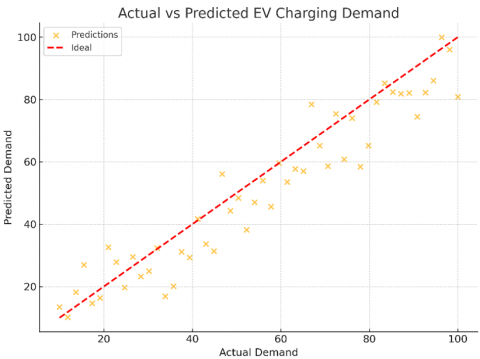
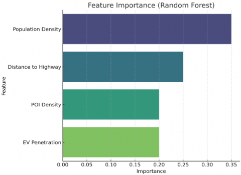
The Random Forest model used for demand forecasting was evaluated using standard regression metrics. The model achieved a coefficient of determination (R²) of 0.84, indicating that it was able to explain 84% of the variance in the observed charging demand. The Root Mean Square Error (RMSE) was 8.7 and the Mean Absolute Error (MAE) was 6.1, both of which suggest good predictive accuracy and low average deviation between actual and predicted values. These metrics reflect the model’s robustness and suitability for spatial demand estimation, reinforcing its utility in supporting infrastructure planning decisions. A Random Forest regression model was trained using input features like population density, distance to highways, POI density, and existing EV penetration. The model predicted spatial charging demand, and its output was normalized and combined with the AHP score.
The final suitability score was computed as:
Final Score= 0.6 x AHP score + 0.4 x Predicted ML Demand
A total of seven criteria were used in the AHP model. The Consistency Ratio was 0.08, indicating reliable pairwise comparisons. The Table 4 below summarizes the selected criteria and their relative importance. And Table 5 gives the steps of proposed methodology using MCDM.
Table 4. Selected criteria for MCDM
|
Sr. No. |
Criterion |
Description |
Weight (AHP) |
|
1 |
Proximity to Roads |
Accessibility and traffic exposure |
0.25 |
|
2 |
Grid/Transformer Access |
Availability of electrical infrastructure |
0.20 |
|
3 |
Population Density |
Indication of residential demand |
0.15 |
|
4 |
Land Cost and Availability |
Economic feasibility |
0.15 |
|
5 |
Traffic Flow Volume |
Utilization potential |
0.10 |
|
6 |
Environmental Sensitivity |
Avoidance of restricted areas |
0.10 |
|
7 |
Proximity to Commercial Institutions |
Service demand in public zones |
0.05 |
Table 5. Steps of MCDM for site selection
|
Steps |
Description |
|
1. Criteria Identification |
Selected 7 key factors influencing EVCI site suitability (e.g., proximity to roads, grid access, population density, etc.) based on literature and expert input. |
|
2. Pairwise Comparison Matrix Construction |
Constructed a matrix using to compare the importance of each criterion against others. |
|
3. AHP Weight Calculation |
Normalized the matrix and calculated the priority weights for each criterion. |
|
4. Consistency Check |
Assessed the consistency of judgments; the Consistency Ratio (CR) was 0.08, indicating acceptable consistency (CR < 0.1). |
|
5. Weighted Overlay in GIS |
Reclassified spatial layers and applied the calculated AHP weights to generate suitability scores via weighted overlay. |
|
6. Suitability Mapping |
Created a suitability map showing the ranking of potential locations for EV charging infrastructure. |
|
7. Hybrid Integration with ML |
Combined the AHP-based scores (60%) with ML-based demand forecasts (40%) to derive the final suitability score. |
Literature on site selection that integrates spatial analysis with mathematical models faces challenges due to the need to address real-world physical and theoretical constraints simultaneously. While numerous solutions to the EVCS location problem have been proposed, with notable success in the papers evaluated in this systematic review, further refinement is required. The MCDM model with more detailed data for significant variables and conducting sensitivity studies on grids of varying sizes can improve parameter evaluation. Including data layers reflecting dynamic vehicle movement and stochastic driving behavior can aid in estimating near real-world service efficiency. Expanding models to account for interregional travel and EV class differentiation, especially for drivers in large metropolitan areas who lack fixed origin-destination patterns, is critical. Additionally, incorporating time-dependent traffic parameters in stochastic programming models can mitigate performance bottlenecks [81]. Queuing theory is also recommended as a solution that can be integrated into decision frameworks and network design models [1].
Real-world driving pattern data derived from GIS can be incorporated into road network operations and traffic control strategies [49]. Combining such data with sensitivity studies at various scales can help establish models for EV charging guidance. This approach could optimize service reliability and reduce system waiting times by strategically locating chargers based on specific traffic patterns. The traffic characteristics around existing fuel stations could be analyzed to optimize charging station coverage [3]. The need for effective MCDM methods and the inclusion of additional technical criteria, recommending the use of artificial intelligence, VIKOR, ELECTRE, PROMETHEE, and micro-level analysis to address knowledge gaps and strengthen the connection between EVCS networks and power distribution [34, 35, 82]. The importance of higher-quality data regarding power distribution criteria to enhance service stability [25].
Engaging community stakeholders is another significant recommendation [83]. Incorporating community input to ensure the relevance of data layers in MCDM models is also an important component [7]. EVCI locations can better align with consumer needs and provide effective coverage through pragmatic model designs. Although equity was not explicitly included in the reviewed papers, it remains a critical factor for policymakers and stakeholders, as its inclusion can ensure fairness in the EVCS location process [12]. Future research should incorporate equity considerations to optimize location selection for all community members.
A notable gap in the literature is the lack of studies addressing EVCI location challenges in rural areas. Most models and methods, whether GIS-based or not, primarily focus on urban applications, often neglecting rural attributes [74, 84]. Addressing the divergent conditions and data availability between rural and urban regions is crucial for expanding research into less populated areas. Site selection is inherently a multi-criteria problem that spans multi-regional and heterogeneous spaces. Integration of charging stations with renewable energy will also be the important factor while considering locations for EVCI [85, 86]. The interactions between urban, suburban, rural, and transitional areas necessitate complementary modelling methods and data selection techniques [87]. However, as the complexity of models increases or more criteria are included, there is no assurance of finding a more optimal solution [88, 89]. Developing all-inclusive frameworks risks conflicts between spatial and mathematical elements. Thus, ongoing evaluations from diverse perspectives and scales are essential for refining tools [90, 91]. Future research should prioritize integrating diverse datasets and methods with varying temporal and spatial parameters to achieve more robust solutions.
The hybrid GIS–MCDM–ML framework described earlier was applied to the Thane district case study. This framework leverages GIS for spatial filtering and feasibility analysis, MCDM (e.g., AHP) for prioritizing candidate sites based on multiple weighted criteria, and ML algorithms (e.g., Random forest) for demand forecasting and user behavior modeling. By combining spatial, contextual, and behavioral data, the framework delivers a ranked list of potential locations supported by predictive insights and visualized outputs. As illustrated in Figure 10, this approach not only enhances transparency and scalability in site selection but also enables dynamic, data-driven planning tailored to evolving urban and grid conditions. Model validation plots in Figures 11 and 12 confirm strong predictive accuracy, as detailed in the Methodology section. The Feature Importance chart in Figure 13 reveals that population density and proximity to highways are the most influential factors in forecasting EV charging demand.
Figure 11. Actual Vs predicted EV charging demand
Figure 12. Residual plot
Figure 13. Feature importance graph (Random Forest)
The proposed hybrid model was validated through a multi-level approach. The AHP component was tested for logical consistency (CR = 0.08) and subjected to sensitivity analysis. The Random Forest regression model achieved high predictive accuracy (R² = 0.89), validated using standard metrics and feature importance alignment. Final suitability maps in Figure 14 were visually and spatially validated against high-demand corridors, with strong overlap observed near urban centers and transport routes. These validations collectively demonstrate the model’s robustness, practical relevance, and potential for scalable deployment in real-world EV infrastructure planning. The sensitivity analysis is carried out and it indicates that ±10% changes in AHP weights result in minimal impact on top-ranked locations, confirming the robustness of the model except in scenarios prioritizing traffic volume, where minor rank shifts occurred. Based on visual interpretation of the final suitability heatmap, approximately 15 to 20 spatial clusters were identified as highly suitable zones shown in Figure 14, primarily located along key transport corridors and urban centers. Informal feedback was collected from two municipal planning officers and a MSEDCL engineer involved in EV grid readiness assessment. They affirmed that the selected criteria, especially transformer access and proximity to highways are consistent with operational considerations in EV infrastructure siting. This feedback supports the practical relevance of the proposed hybrid framework.
Figure 14. Final EV charging station suitability map- Thane District
Despite the robustness of the proposed hybrid framework, the reliability of the results is inherently dependent on the correctness and resolution of spatial datasets used, such as land use maps, road networks, and demographic layers. Additionally, the absence of real-time data sources such as GPS mobility traces or live traffic feeds and limited integration of user behavior patterns may affect the responsiveness of the model in dynamic urban contexts. While the model performs well in the Thane district case, generalizing it to other regions may require recalibration of MCDM weights and retraining of ML models to reflect local socio-economic and infrastructural variations.
To assess the effectiveness of the proposed framework, it is compared qualitatively with selected models from recent studies. Traditional GIS-only models provide robust spatial visualization but lack predictive power. MCDM-based models offer structured decision-making but depend heavily on expert judgment [26]. ML models improve prediction accuracy but often ignore spatial and stakeholder inputs. Our hybrid approach combines the spatial accuracy of GIS, the decision structure of MCDM, and the learning capability of ML, offering better adaptability and more comprehensive outputs. This integrated approach is particularly advantageous for region-specific planning, where both spatial precision and demand prediction are essential. The proposed framework depends on spatial and socio-economic data; poor data can reduce accuracy. It also involves computational complexity, making large-scale or real-time use challenging. Recalibration is needed for different regions, and limited real-time or behavioral data may affect responsiveness in dynamic scenarios.
Effective planning and deployment of EVCI is crucial to support the accelerating adoption of EVs and to ensure that charging networks are both accessible and efficient. In this Review, we analyzed 91 research articles published over the past decade to provide a comprehensive perspective on the methods, models, and decision-support systems used for EVCI location planning. Our findings reveal that GIS-based tools, MCDM approaches, and optimization techniques dominate the existing literature, while interest in machine learning applications is steadily growing. We identify key influencing factors such as traffic flow, power grid capacity, user behavior, and land costs and examine how these variables are addressed across different methodologies. Comparative tables are provided to illustrate the strengths, limitations, and practical applications of each approach.
Going beyond a conventional review, we introduce a conceptual hybrid framework that combines spatial filtering, MCDM-based prioritization, and machine learning-driven demand forecasting. This integrated approach is designed to overcome persistent challenges in the literature, such as the limited use of real-time or behavioral data and the lack of multi-layered decision-making strategies. The study also outlines promising directions for future research. These include incorporating dynamic data sources like GPS and IoT, developing user behavior models to support more user-centric site selection, and adopting equity-driven planning strategies to serve underrepresented communities. Different machine learning models can also be integrated with alternative MCDM techniques such as TOPSIS or VIKOR to enhance the adaptability, precision, and decision-support capabilities of the framework across varied urban contexts. These insights aim to guide urban planners, policymakers, and researchers in developing more sustainable, data-informed, and inclusive EVCI networks. Although this study focuses on the Thane district, the proposed framework is designed to be adaptable to other regions. The methodology allows for recalibration of MCDM criteria weights based on local priorities and stakeholder input. GIS layers can be replaced with region-specific spatial datasets, and the machine learning model can be retrained using local EV adoption and traffic patterns. This flexibility makes the framework suitable for both urban and semi-urban planning contexts.
[1] Bian, C., Li, H., Wallin, F., Avelin, A., Lin, L., Yu, Z. (2019). Finding the optimal location for public charging stations–A GIS-based MILP approach. Energy Procedia, 158: 6582-6588. https://doi.org/10.1016/j.egypro.2019.01.071
[2] Sadeghi-Barzani, P., Rajabi-Ghahnavieh, A., Kazemi-Karegar, H. (2014). Optimal fast charging station placing and sizing. Applied Energy, 125: 289-299. https://doi.org/10.1016/j.apenergy.2014.03.077
[3] Zafar, U., Bayram, I.S., Bayhan, S. (2021). A GIS-based optimal facility location framework for fast electric vehicle charging stations. In 2021 IEEE 30th International Symposium on Industrial Electronics (ISIE), Kyoto, Japan, pp. 1-5. https://doi.org/10.1109/ISIE45552.2021.9576448
[4] Ferraz, R.S., Ferraz, R.S., Rueda-Medina, A.C., Fardin, J.F. (2023). Multi-objective optimization approach for allocation of electric vehicles parking lots and smart charging with distributed energy resource. Journal of Control, Automation and Electrical Systems, 34(5): 1070-1079. https://doi.org/10.1007/s40313-023-01027-z
[5] Yu, S., Wang, Y., Zhang, R., Wang, J. (2023). A three-step heuristic approach to the electric vehicle path planning problem considering charging. Journal of Advanced Transportation, 2023(1): 9930694. https://doi.org/10.1155/2023/9930694
[6] Hildebrand, N., Kummer, S. (2024). Systematic literature review of urban charging infrastructure planning over time. Cleaner Energy Systems, 8: 100123. https://doi.org/10.1016/j.cles.2024.100123
[7] Guler, D., Yomralioglu, T. (2020). Suitable location selection for the electric vehicle fast charging station with AHP and fuzzy AHP methods using GIS. Annals of GIS, 26(2): 169-189. https://doi.org/10.1080/19475683.2020.1737226
[8] Ghosh, A., Ghorui, N., Mondal, S.P., Kumari, S., Mondal, B.K., Das, A., Gupta, M.S. (2021). Application of hexagonal fuzzy MCDM methodology for site selection of electric vehicle charging station. Mathematics, 9(4): 393. https://doi.org/10.3390/math9040393
[9] Golsefidi, A.H., Hüttel, F.B., Peled, I., Samaranayake, S., Pereira, F.C. (2023). A joint machine learning and optimization approach for incremental expansion of electric vehicle charging infrastructure. Transportation Research Part A: Policy and Practice, 178: 103863. https://doi.org/10.1016/j.tra.2023.103863
[10] Pradhan, S., Ghose, D., Shabbiruddin. (2021). Planning and design of suitable sites for electric vehicle charging station–A case study. International Journal of Sustainable Engineering, 14(3): 404-418. https://doi.org/10.1080/19397038.2020.1862347
[11] Iravani, H. (2022). A multicriteria GIS-based decision-making approach for locating electric vehicle charging stations. Transportation Engineering, 9: 100135. https://doi.org/10.1016/j.treng.2022.100135
[12] Zhou, J., Wu, Y., Wu, C., He, F., Zhang, B., Liu, F. (2020). A geographical information system based multi-criteria decision-making approach for location analysis and evaluation of urban photovoltaic charging station: A case study in Beijing. Energy Conversion and Management, 205: 112340. https://doi.org/10.1016/j.enconman.2019.112340
[13] Rane, N.L., Achari, A., Saha, A., Poddar, I., Rane, J., Pande, C.B., Roy, R. (2023). An integrated GIS, MIF, and TOPSIS approach for appraising electric vehicle charging station suitability zones in Mumbai, India. Sustainable Cities and Society, 97: 104717. https://doi.org/10.1016/j.scs.2023.104717
[14] Maybury, L., Corcoran, P., Cipcigan, L. (2022). Mathematical modelling of electric vehicle adoption: A systematic literature review. Transportation Research Part D: Transport and Environment, 107: 103278. https://doi.org/10.1016/j.trd.2022.103278
[15] Guo, Z., Wang, Y. (2023). Anticipatory planning for equitable and productive curbside electric vehicle charging stations. Sustainable Cities and Society, 99: 104962. https://doi.org/10.1016/j.scs.2023.104962
[16] Pagany, R., Ramirez Camargo, L., Dorner, W. (2019). A review of spatial localization methodologies for the electric vehicle charging infrastructure. International Journal of Sustainable Transportation, 13(6): 433-449. https://doi.org/10.1080/15568318.2018.1481243
[17] Vélez-Falconí, M., Marín, J., Jiménez, S., Guachi-Guachi, L. (2020). Comparative study of distance measures for the fuzzy C-means and K-means non-supervised methods applied to image segmentation. In ICAI Workshops, pp. 1-14.
[18] Zhang, B., Zhao, M., Hu, X. (2023). Location planning of electric vehicle charging station with users’ preferences and waiting time: Multi-objective bi-level programming model and HNSGA-II algorithm. International Journal of Production Research, 61(5): 1394-1423. https://doi.org/10.1080/00207543.2021.2023832
[19] Rane, N.L., Choudhary, S. (2023). Fuzzy AHP and Fuzzy TOPSIS as an effective and powerful Multi-Criteria Decision-Making (MCDM) method for subjective judgements in selection process. International Research Journal of Modernization in Engineering Technology and Science, 5(4): 3786-3799. https://doi.org/10.56726/irjmets36629
[20] Rana, V.S., ul haq, M.Z., Mathur, N., Khera, G.S., Dixit, S., Singh, S., Prakash, A., Viktorovna, G.V., Soloveva, O.V., Solovev, S.A. (2024). Assortment of latent heat storage materials using multi criterion decision making techniques in Scheffler solar reflector. International Journal on Interactive Design and Manufacturing (IJIDeM), 18(5): 3115-3129. https://doi.org/10.1007/s12008-023-01456-9
[21] Libório, M.P., Ekel, P.I., Laudares, S., da Silva Martins, C.A.P. (2024). A goal-based weighting for composite indicators constructed through Ordered Weighted Averaging (OWA) operator. MethodsX, 12: 102575. https://doi.org/10.1016/j.mex.2024.102575
[22] Sunardi, Umar, R., Sahara, D. (2022). Best employee decision using multi attribute utility theory method. Jurnal RESTI (Rekayasa Sistem Dan Teknologi Informasi), 6(6): 945-951. https://doi.org/10.29207/resti.v6i6.4318
[23] Rahman, N. (2024). Multi-criteria decision-making for information science program ranking using the ELECTRE method. Library of Progress-Library Science, Information Technology & Computer, 44(3): 17266-17273. https://doi.org/10.48165/bapas.2024.44.2.1
[24] Costa, E., Vanhaverbeke, L., Coosemans, T., Seixas, J., Messagie, M., Costa, G. (2019). Optimizing the location of charging infrastructure for future expansion of electricvehicle in Sao Paulo, Brazil. In 2019 IEEE International Smart Cities Conference (ISC2), Casablanca, Morocco, pp. 632-637. https://doi.org/10.1109/ISC246665.2019.9071676
[25] Archana, A.N., Rajeev, T. (2023). A novel electric vehicle placement index for sustaining power quality in a distribution network: Proper allocation of electric vehicle charging stations. IEEE Industry Applications Magazine, 29(5): 23-35. https://doi.org/10.1109/MIAS.2023.3264860
[26] De Oliveira, M.S., Steffen, V., Trojan, F. (2024). Systematic literature review on electric vehicles and multicriteria decision making: Trends, rankings, and future perspectives. Journal of Intelligent Management Decision, 3(1): 22-41. https://doi.org/10.56578/jimd030103
[27] Wang, Y.J. (2015). A fuzzy multi-criteria decision-making model based on simple additive weighting method and relative preference relation. Applied Soft Computing, 30: 412-420. https://doi.org/10.1016/j.asoc.2015.02.002
[28] Saaty, T.L. (2008). Decision making with the analytic hierarchy process. International Journal of Services Sciences, 1(1): 83-98. https://doi.org/10.1504/IJSSCI.2008.017590
[29] Csiszár, C., Csonka, B., Földes, D., Wirth, E., Lovas, T. (2020). Location optimisation method for fast-charging stations along national roads. Journal of Transport Geography, 88: 102833. https://doi.org/10.1016/j.jtrangeo.2020.102833
[30] Wong, B.Y.M., Faulkner, G., Buliung, R. (2011). GIS measured environmental correlates of active school transport: A systematic review of 14 studies. International Journal of Behavioral Nutrition and Physical Activity, 8: 1-22. https://doi.org/10.1186/1479-5868-8-39
[31] Yap, J.Y.L., Ho, C.C., Ting, C.Y. (2019). A systematic review of the applications of multi-criteria decision-making methods in site selection problems. Built Environment Project and Asset Management, 9(4): 548-563. https://doi.org/10.1108/BEPAM-05-2018-0078
[32] Tatit, P., Adhinugraha, K., Taniar, D. (2024). Navigating the maps: Euclidean vs. road network distances in spatial queries. Algorithms, 17(1): 29. https://doi.org/10.3390/a17010029
[33] Salarpour, A., Khotanlou, H. (2018). An empirical comparison of distance measures for multivariate time series clustering. International Journal of Engineering, Transactions B: Applications, 31: 250-262. https://doi.org/10.5829/ije.2018.31.02b.08
[34] Kaya, Ö., Alemdar, K.D., Çodur, M.Y. (2020). A novel two stage approach for electric taxis charging station site selection. Sustainable Cities and Society, 62: 102396. https://doi.org/10.1016/j.scs.2020.102396
[35] Li, K., Shao, C., Hu, Z., Shahidehpour, M. (2022). An MILP method for optimal planning of electric vehicle charging stations in coordinated urban power and transportation networks. IEEE Transactions on Power Systems, 38(6): 5406-5419. https://doi.org/10.1109/TPWRS.2022.3221163
[36] Roy, S., Singha, N., Bose, A., Basak, D., Chowdhury, I.R. (2023). Multi-influencing factor (MIF) and RS–GIS-based determination of agriculture site suitability for achieving sustainable development of Sub-Himalayan region, India. Environment, Development and Sustainability, 25(7): 7101-7133. https://doi.org/10.1007/s10668-022-02360-0
[37] Rane, N.L., Günen, M.A., Mallick, S.K., Rane, J., et al. (2024). GIS-based multi-influencing factor (MIF) application for optimal site selection of solar photovoltaic power plant in Nashik, India. Environmental Sciences Europe, 36(1): 5. https://doi.org/10.1186/s12302-023-00832-2
[38] Fenta, A.A., Kifle, A., Gebreyohannes, T., Hailu, G. (2015). Spatial analysis of groundwater potential using remote sensing and GIS-based multi-criteria evaluation in Raya Valley, northern Ethiopia. Hydrogeology Journal, 23(1): 195-206. https://doi.org/10.1007/s10040-014-1198-x
[39] Murugan, M., Marisamynathan, S. (2023). Investigating the Individual house holders’ preference to adopt home-based charging and solar rooftop facility for electric vehicle charging. Transportation Letters, 15(8): 845-859. https://doi.org/10.1080/19427867.2022.2101310
[40] Chiu, W.Y., Yen, G.G., Juan, T.K. (2016). Minimum Manhattan distance approach to multiple criteria decision making in multiobjective optimization problems. IEEE Transactions on Evolutionary Computation, 20(6): 972-985. https://doi.org/10.1109/TEVC.2016.2564158
[41] Sisman, S., Ergul, I., Aydinoglu, A.C. (2021). Designing GIS-based site selection model for urban investment planning in smart cities with the case of electric vehicle charging stations. The International Archives of the Photogrammetry, Remote Sensing and Spatial Information Sciences, 46: 515-522. https://doi.org/10.5194/isprs-archives-XLVI-4-W5-2021-515-2021
[42] Costa, E., Paiva, A., Seixas, J., Baptista, P., Costa, G., Gallachoir, B.O. (2017). Suitable locations for electric vehicles charging infrastructure in Rio de Janeiro, Brazil. In 2017 IEEE Vehicle Power and Propulsion Conference (VPPC), Belfort, France, pp. 1-7. https://doi.org/10.1109/VPPC.2017.8330964
[43] Ahmad, F., Bilal, M. (2023). A comprehensive analysis of electric vehicle charging infrastructure, standards, policies, aggregators and challenges for the Indian market. Energy Sources, Part A: Recovery, Utilization, and Environmental Effects, 45(3): 8601-8622. https://doi.org/10.1080/15567036.2023.2228734
[44] Schmidt, M., Zmuda-Trzebiatowski, P., Kiciński, M., Sawicki, P., Lasak, K. (2021). Multiple-criteria-based electric vehicle charging infrastructure design problem. Energies, 14(11): 3214. https://doi.org/10.3390/en14113214
[45] Alia, M.M.M., Deshmukh, A.A. (2022). E-vehicle: Literature review. International Management Review, 18(2): 87-92.
[46] Kethareswaran, V., Moulik, S. (2023). Electric Vehicles and the burning question: Reasons, risks, ramifications and remedies—An Indian perspective. Fire Technology, 59(5): 2189-2201. https://doi.org/10.1007/s10694-023-01453-0
[47] Alagu, M., Selladurai, R., Chelladurai, C. (2022). Simultaneous placement of electric vehicle charging station and DG units in urban area using novel enhanced antlion optimizer. Journal of Intelligent & Fuzzy Systems, 43(1): 707-719. https://doi.org/10.3233/JIFS-212401
[48] Akshay, K.C., Grace, G.H., Gunasekaran, K., Samikannu, R. (2024). Power consumption prediction for electric vehicle charging stations and forecasting income. Scientific Reports, 14(1): 6497. https://doi.org/10.1038/s41598-024-56507-2
[49] Aydin, F., Gümüş, B. (2022). Comparative analysis of multi-criteria decision making methods for the assessment of optimal SVC location. Bulletin of the Polish Academy of Sciences. Technical Sciences, 70(2): e140555. http://dx.doi.org/10.24425/bpasts.2022.140555
[50] Liu, J., Nie, J., Zhang, W., Li, L., Yuan, H. (2024). Product development strategies of electric vehicle manufacturers: Considering government subsidy and consumers' environmental preferences. Technological Forecasting and Social Change, 201: 123222. https://doi.org/10.1016/j.techfore.2024.123222
[51] Ronanki, D., Karneddi, H. (2023). Electric vehicle charging infrastructure: Review, cyber security considerations, potential impacts, countermeasures, and future trends. IEEE Journal of Emerging and Selected Topics in Power Electronics, 12(1): 242-256. https://doi.org/10.1109/JESTPE.2023.3336997
[52] Nehiba, C. (2024). Electric vehicle usage, pollution damages, and the electricity price elasticity of driving. Journal of Environmental Economics and Management, 124: 102915. https://doi.org/10.1016/j.jeem.2023.102915
[53] Burlig, F., Bushnell, J., Rapson, D., Wolfram, C. (2021). Low energy: Estimating electric vehicle electricity use. AEA Papers and Proceedings, 111: 430-435. https://doi.org/10.1257/pandp.20211088
[54] Al-Ghussain, L., Darwish Ahmad, A., Abubaker, A.M., Alrbai, M., Ayadi, O., Al-Dahidi, S., Akafuah, N.K. (2023). Techno-economic assessment of photovoltaic-based charging stations for electric vehicles in developing countries. Energy Sources, Part A: Recovery, Utilization, and Environmental Effects, 45(1): 523-541. https://doi.org/10.1080/15567036.2023.2171517
[55] Chen, Q., Huang, K., Ferguson, M.R. (2022). Capacity expansion strategies for electric vehicle charging networks: Model, algorithms, and case study. Naval Research Logistics (NRL), 69(3): 442-460. https://doi.org/10.1002/nav.22027
[56] Raut, S.M., Bapuji, S., Mahavidyalaya, S. (2022). A study of sales trend of e-vehicles in India and Maharashtra. International Journal for Research Trends and Innovation, 7(5): 667-670.
[57] Clampitt, C., Ahmed, S.A. (2022). Electric vehicle sales and infrastructure analysis. Performance Improvement Journal, 61(1): 10-18. https://doi.org/10.56811/pfi-21-0045
[58] Ben Lazreg, M., Baccouche, I., Jemmali, S., Manai, B., Hamouda, M. (2023). State of charge estimation of lithium-ion battery in electric vehicles using the smooth variable structure filter: Robustness evaluation against noise and parameters uncertainties. Electric Power Components and Systems, 51(15): 1630-1647. https://doi.org/10.1080/15325008.2023.2201285
[59] Acar, E., Jain, N., Ramu, P., Hwang, C., Lee, I. (2024). A survey on design optimization of battery electric vehicle components, systems, and management. Structural and Multidisciplinary Optimization, 67(3): 27. https://doi.org/10.1007/s00158-024-03737-7
[60] Koirala, K., Tamang, M. (2022). Planning and establishment of battery swapping station-A support for faster electric vehicle adoption. Journal of Energy Storage, 51: 104351. https://doi.org/10.1016/j.est.2022.104351
[61] Zhou, Y. (2024). Toward sustainable cities: Where the electric vehicle users reside matters. Economics Letters, 235: 111535. https://doi.org/10.1016/j.econlet.2024.111535
[62] Song, M.R., Chu, W., Im, M. (2022). The effect of cultural and psychological characteristics on the purchase behavior and satisfaction of electric vehicles: A comparative study of US and China. International Journal of Consumer Studies, 46(1): 345-364. https://doi.org/10.1111/ijcs.12684
[63] Brenna, M., Foiadelli, F., Leone, C., Longo, M. (2020). Electric vehicles charging technology review and optimal size estimation. Journal of Electrical Engineering & Technology, 15: 2539-2552. https://doi.org/10.1007/s42835-020-00547-x
[64] Goel, S., Sharma, R., Rathore, A.K. (2021). A review on barrier and challenges of electric vehicle in India and vehicle to grid optimisation. Transportation Engineering, 4: 100057. https://doi.org/10.1016/j.treng.2021.100057
[65] He, S.Y., Kuo, Y.H., Wu, D. (2016). Incorporating institutional and spatial factors in the selection of the optimal locations of public electric vehicle charging facilities: A case study of Beijing, China. Transportation Research Part C: Emerging Technologies, 67: 131-148. https://doi.org/10.1016/j.trc.2016.02.003
[66] Hisoglu, S., Comert, R. (2021). GIS-based optimum site selection for solar electric vehicle charging station: Ankara-Istanbul highway case. The International Archives of the Photogrammetry, Remote Sensing and Spatial Information Sciences, 46: 267-272. https://doi.org/10.5194/isprs-archives-XLVI-4-W5-2021-267-2021
[67] Dinc Yalcin, G., Ozsoy, C.Y., Taskin, Y. (2022). A multi-objective mathematical model for the electric vehicle charging station placement problem in urban areas. International Journal of Sustainable Energy, 41(8): 945-961. https://doi.org/10.1080/14786451.2021.2016761
[68] Chaopaisarn, P., Maijandang, T., Banomyong, R. (2025). Charging ahead: Strategic placement of electric vehicle charging stations in Thailand. Asia Pacific Business Review, 1-30. https://doi.org/10.1080/13602381.2025.2450481
[69] Wang, X., Xia, W., Yao, L., Zhao, X. (2023). Improved Bayesian best-worst networks with geographic information system for electric vehicle charging station selection. IEEE Access, 12: 758-771. https://doi.org/10.1109/ACCESS.2023.3347037
[70] Xydis, G., Nanaki, E. (2015). Wind energy based electric vehicle charging stations sitting. A GIS/wind resource assessment approach. Challenges, 6(2): 258-270. https://doi.org/10.3390/challe6020258
[71] Straka, M., Buzna, L.U. (2019). Preprocessing of GIS data for electric vehicle charging stations analysis and evaluation of the predictors significance. Transportation Research Procedia, 40: 1583-1590. https://doi.org/10.1016/j.trpro.2019.07.219
[72] Ghosh, N., Mothilal Bhagavathy, S., Thakur, J. (2022). Accelerating electric vehicle adoption: Techno-economic assessment to modify existing fuel stations with fast charging infrastructure. Clean Technologies and Environmental Policy, 24(10): 3033-3046. https://doi.org/10.1007/s10098-022-02406-x
[73] Banegas, J., Mamkhezri, J. (2023). A systematic review of geographic information systems based methods and criteria used for electric vehicle charging station site selection. Environmental Science and Pollution Research, 30(26): 68054-68083. https://doi.org/10.1007/s11356-023-27383-6
[74] Shapcott, Z. (2024). An Investigation into Distance Measures in Cluster Analysis. arXiv preprint arXiv:2404.13664. https://doi.org/10.48550/arXiv.2404.13664
[75] Sathyan, S., Pandi, V.R., Antony, A., Salkuti, S.R., Sreekumar, P. (2024). ANN-based energy management system for PV-powered EV charging station with battery backup and vehicle to grid support. International Journal of Green Energy, 21(6): 1279-1294. https://doi.org/10.1080/15435075.2023.2246048
[76] Sentinel-2. https://scihub.copernicus.eu/, accessed on 7, Feb. 2025.
[77] Landsat. https://earthexplorer.usgs.gov/, accessed on 9, Feb. 2025.
[78] MODIS. https://www.earthdata.nasa.gov/, accessed on 25, Jan. 2025.
[79] LiDAR. https://opentopography.org/, accessed on 20, Jan. 2025.
[80] SRTM. https://www.usgs.gov /centers/eros/science/usgs-eros-archive-digital-elevation-shuttle-radar-topography-mission-srtm, accessed on 25, Jan. 2025.
[81] Sundarakani, B., Rajamani, H.S., Madmoune, A. (2024). Sustainability study of electric vehicles performance in the UAE: Moderated by blockchain. Benchmarking: An International Journal, 31(1): 199-219. https://doi.org/10.1108/BIJ-10-2021-0624
[82] Lei, F., Cai, Q., Wei, G., Mo, Z., Guo, Y. (2023). RETRACTED: Probabilistic double hierarchy linguistic MADM for location selection of new energy electric vehicle charging stations based on the MSM operators. Journal of Intelligent & Fuzzy Systems, 44(3): 5195-5216. https://doi.org/10.3233/JIFS-221979
[83] Krehic, L. (2022). How do increases in electric vehicle use affect urban toll ring prices? Public Choice, 193(3): 187-209. https://doi.org/10.1007/s11127-022-01008-x
[84] Singh, S., Jindel, J., Tikkiwal, V.A., Verma, M., Gupta, A., Negi, A., Jain, A. (2022). Electric vehicles for low-emission urban mobility: Current status and policy review for India. International Journal of Sustainable Energy, 41(9): 1323-1359. https://doi.org/10.1080/14786451.2022.2050232
[85] Kannayeram, G., Muniraj, R., Saravanan, R. (2023). Impacts of electric vehicle charging station with the integration of renewable energy with grid connected system: A hybrid technique. Clean Technologies and Environmental Policy, 25(7): 2433-2450. https://doi.org/10.1007/s10098-023-02548-6
[86] Nandini, K.K., Jayalakshmi, N.S. (2024). A combined approach to evaluate power quality and grid dependency by solar photovoltaic based electric vehicle charging station using hybrid optimization. Journal of Energy Storage, 84: 110967. https://doi.org/10.1016/j.est.2024.110967
[87] Sisman, S., Aydinoglu, A.C. (2020). Using GIS-based multi-criteria decision analysis techniques in the smart cities. The International Archives of the Photogrammetry, Remote Sensing and Spatial Information Sciences, 44: 383-389. https://doi.org/10.5194/isprs-archives-XLIV-4-W3-2020-383-2020
[88] Valogianni, K., Ketter, W., Collins, J., Zhdanov, D. (2020). Sustainable electric vehicle charging using adaptive pricing. Production and Operations Management, 29(6): 1550-1572. https://doi.org/10.1111/poms.13179
[89] Raposo, J., Rodrigues, A., Silva, C., Dentinho, T. (2015). A multi-criteria decision aid methodology to design electric vehicles public charging networks. AIP Advances, 5(5): 057123. https://doi.org/10.1063/1.4921087
[90] Ullah, I., Liu, K., Yamamoto, T., Shafiullah, M., Jamal, A. (2023). Grey wolf optimizer-based machine learning algorithm to predict electric vehicle charging duration time. Transportation Letters, 15(8): 889-906. https://doi.org/10.1080/19427867.2022.2111902
[91] Mastoi, M.S., Zhuang, S., Munir, H.M., Haris, M., et al. (2022). An in-depth analysis of electric vehicle charging station infrastructure, policy implications, and future trends. Energy Reports, 8: 11504-11529. https://doi.org/10.1016/j.egyr.2022.09.011