Ying Qiao | Feng Gao*
© 2022 IIETA. This article is published by IIETA and is licensed under the CC BY 4.0 license (http://creativecommons.org/licenses/by/4.0/).
OPEN ACCESS
Objective of this research is to accurately stimulate the hydrodynamic process in reservoirs thereby summarizing the hydrodynamics in reservoirs and figuring out its impact on the migration, conversion, and concentration of pollutants. For this purpose, this paper employed a 2D unstructured shallow water hydrodynamic model to perform numerical simulation on the flow field of the Yazidang Reservoir, one of the major reservoirs in the Ningxia Hui Autonomous Region of China; grids of shore boundaries in the model were densified to better fit the terrain changes at the boundaries, and the impact of wind field, and inflow/outflow on the flow field in the target reservoir was studied. The research findings suggest that, wind velocity has a great impact on the circulation intensity of the target reservoir, but it has no obvious impact on the circulation structure; the inflow and outflow have a certain impact on the area near the water inlet and outlet, and the range of this impact is related to the size of water volume of the inflow/outflow; under calm wind condition, the flow field of Yazidang Reservoir is entirely determined by the inflow and outflow, but the impact on the area far from the water inlet and outlet is very small, and wind field is one of the decisive factors for the flow field of Yazidang Reservoir. The research conclusions attained in this paper could provide useful theoretical evidences for the water ecological security of Yazidang Reservoir.
Yazidang Reservoir, circulation, numerical simulation, wind field, boundary
Among the various types of reservoirs, lake reservoirs are the most frequently visited by humans, and the frequency of human activities around lake reservoirs is the highest. Under the threats of both natural and human factors, the water ecology of lake reservoirs has been damaged to varying degrees in recent years, which has also seriously endangered the living quality of local residents and the sustainable development of surrounding environment. In this context, if we want to change this status quo of lake reservoirs, then it’s necessary to study the hydrodynamics of lake reservoirs and figure out the influencing factors of it, and this work has important scientific meaning and practical value for the management of lake water environment and the improvement of water quality of lake reservoirs [1].
Since the hydrodynamics of shallow lakes generally have the features of uneven spatial distribution and small circulation volume, which makes it difficult to study it through simultaneous observations [2], so the numerical simulation method is often adopted to solve this problem [3]. For example, scholar Simons [4] developed numerical models to study the hydrodynamics of Lake Ontario for the first time, and briefly introduced the construction of 3D hydrodynamic equations. In the Chinese academic circle, key targets of research on lake reservoirs include 6 major lakes and 3 major reservoirs [5] such as the Taihu Lake and the Three Gorges Reservoir. Xu and Liu [1] established a 2D shallow water hydrodynamic model for Taihu Lake, analyzed the basic flow state of the wind-induced circulation in Taihu, and carried out numerical simulation on the features and laws of the hydrodynamic distribution of Taihu under different wind conditions. Hu et al. [6-8] carried out numerical simulation on the 3D hydrodynamics of Taihu Lake, and respectively studied the wind-induced circulation of Taihu from the aspects of wind-driven surges, typical wind field, and the reclamation project of Wuxi Mashan. Han et al. [9] studied the impact of wind velocity on the structure of stratified flow field and the vertical average flow field in Zhuhu Lake, they gave the critical wind velocity value under the combined effects of wind field and inflow/outflow, and discovered that wind direction and inflow/outflow are the primary influencing factors of critical wind velocity. Through these research findings, we can understand the changes in the wind-induced circulation of the lake area under different wind fields, however, studies about the impact of terrain and inflow/outflow on the lake flow field are insufficient. Zhang et al. [10] studied the impact of some typical lake bottom terrains on the lake flow field, and found that the changes of lake bottom terrain have an impact on the average wind flow field of each layer. Jiang et al. [11] studied the flow field of Taihu Lake under two conditions: one condition is the actual lake bottom terrain of Taihu, while the other condition assumed the lake bottom is flat; and their research found that no circulation has been formed under the flat lake bottom condition. Han et al. [12] studied the impact of inflow/outflow on the flow field structure of Zhuhu Lake. Existing studies mostly focus on the impact of wind velocity, wind direction and terrain on lake circulation. Although it’s clear that lake shore boundaries do have a certain impact on lake circulation, the quantitative research is insufficient, and fewer of them have concerned about the impact of terrain, wind field, and lake inflow/outflow on the flow field of the reservoir.
Based on previous studies, we designed multiple work conditions for the numerical simulation of circulation in the Yazidang Reservoir, and established a 2D shallow water hydrodynamic model to simulate different wind fields, inflow/outflow volumes, and inlet/outlet methods to study the circulation in the target reservoir and its influencing factors, in the hopes of offering evidences for ensuring water safety of Yazidang Reservoir.
2.1 About the model
Since the simulation and calculation of the hydrodynamics of the target reservoir must deal with irregular boundaries and complex terrains, this paper built a 2D hydrodynamic model using unstructured triangular grids, in which any triangular is taken as the unit of calculation. A finite-volume unit center method was adopted to solve the equations, and the established 2D hydrodynamic model was used to calculate the hydrodynamics of the target reservoir [13-17] and analyze the hydrodynamic process under different influencing factors, thereby providing theoretical evidences for the management of water environment and the improvement of water quality of the Yazidang Reservoir.
Water flow continuity equation:
$\frac{\partial Z}{\partial t}+\frac{\partial(h u)}{\partial x}+\frac{\partial(h v)}{\partial y}=0$ (1)
Hydrodynamics equations of the water flow:
$\frac{\partial u}{\partial t}+\frac{\partial u^{2}}{\partial x}+\frac{\partial v u}{\partial y}=f v-g \frac{\partial \eta}{\partial x}-\frac{1}{\rho_{0}} \frac{\partial p_{a}}{\partial x}-\frac{1}{\rho_{0} h}\left(\frac{\partial s_{x x}}{\partial x}+\right.$$\left.\frac{\partial s_{x y}}{\partial y}\right)+F_{u}+u_{s} S$ (2)
$\frac{\partial v}{\partial t}+\frac{\partial v^{2}}{\partial y}+\frac{\partial u v}{\partial x}=-f u-g \frac{\partial \eta}{\partial y}-\frac{1}{\rho_{0}} \frac{\partial p_{a}}{\partial y}-\frac{1}{\rho_{0} h}\left(\frac{\partial s_{y x}}{\partial x}+\right.$$\left.\frac{\partial s_{y y}}{\partial y}\right)+F_{v}+v_{s} S$ (3)
where, t represents the time, unit is s; x represents the horizontal coordinate in space, unit is m; y represents the vertical coordinate in space, unit is m; Z represents the water level at (x, y), unit is m; h represents the water depth at (x, y), unit is m; u represents the component of flow velocity in the x direction, unit is m/s; v represents the component of flow velocity in the y direction, unit is m/s; g represents the acceleration of gravity, unit is m/s2; n represents the Manning coefficient; fv and fu are the Coriolis acceleration terms; $g \frac{\partial \eta}{\partial x}$ and $g \frac{\partial \eta}{\partial y}$ are surface water level acceleration terms; $\frac{1}{\rho_{0}} \frac{\partial p_{a}}{\partial x}$ and $\frac{1}{\rho_{0}} \frac{\partial p_{a}}{\partial y}$ are atmospheric pressure gradient terms; $\frac{1}{\rho_{0} h}\left(\frac{\partial s_{x x}}{\partial x}+\frac{\partial s_{x y}}{\partial y}\right)$ and $\frac{1}{\rho_{0} h}\left(\frac{\partial s_{y x}}{\partial x}+\frac{\partial s_{y y}}{\partial y}\right)$ are wave radiation stress terms; Fu and Fv are horizontal eddy viscosity terms; usS and vsS are the acceleration terms generated by the inflow of the source term.
The model was solved by the finite volume method, the vertical direction was transformed by σ coordinates, the horizontal direction was solved by rectangular or orthogonal curvilinear coordinates. The dynamic equations were solving by the finite difference method, the horizontal direction was subject to staggered grid discretization, the second-order precision finite difference method and the internal/external schema splitting technology were adopted for time integral, and a limiter function in second-order TVD format was used to avoid numerical oscillations.
2.2 Model configuration
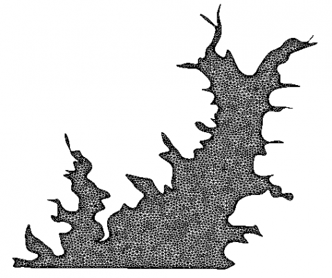
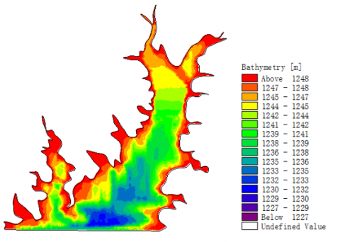
Since the Yazidang Reservoir only covers a small area and it is irregular in shape, this paper used unstructured grids to better fit the complex lakeshore boundaries. 6295 nodes and 21626 units had been set; the meshing of the Yazidang Reservoir area is shown in Figure 1. The terrain was interpolated into each grid node using an inverse distance weighted method. To better fit the terrain changes at the boundaries, the grids near the lakeshore boundaries were densified, a map of the topography was attained, as shown in Figure 2. The initial water level of model operation was taken as an approximation of the actual initial conditions, the initial water level was set as an elevation of 346m, and the initial flow velocity was 0m/s.
Figure 1. Meshing of the Yazidang Reservoir
Figure 2. Topography of the Yazidang Reservoir
3.1 The impact of wind velocity on flow field
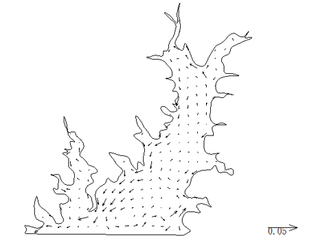
(a) Flow field distribution under 1.4m/s N wind
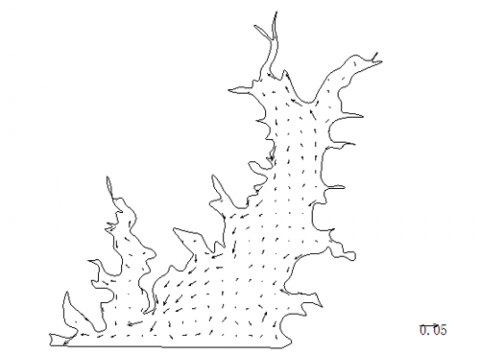
(b) Flow field distribution under 3.21m/s N wind
Figure 4. Flow field distribution maps of the Yazidang Reservoir
Wind is an important factor that can disturb the flow field in reservoir. According to statistics, in the eastern part of Ningxia, the maximum hourly average wind velocity is 3.21 m/s, the minimum hourly average wind velocity is 1.40 m/s, the annual dominant wind direction is N wind, the dominant wind direction in summer is SSE wind, and the dominant wind direction in winter is N wind. In order to compare the impact of wind velocity on the flow field in the target reservoir, this chapter gave the reservoir flow field distribution structure under two typical conditions: 1.4m/s N wind, and 3.21m/s N wind. The two figures (a) and (b) in Figure 4 give the distribution maps of the simulated flow field under these two conditions.
According to the numerical simulation results, under the continuous action of N wind, the target area reached a steady state. There’re great differences in the flow velocity of different areas of the Yazidang Reservoir. The flow velocity in the nearshore area was much larger than that in the center of the reservoir. In the entire reservoir area, the flow velocity of the west side was much greater than that in other areas, and the flow velocity in the rest part was relatively small. Basically, wind velocity had no impact on the circulation structure of the target reservoir, there’re two circulations of different sizes, the one at the center of the reservoir was larger in size, and the circulation direction was counterclockwise.
3.2 The impact of wind direction on flow field
In this section, the impact of wind velocity on the flow field in the target reservoir was studied, and it’s found that wind velocity didn’t have a great impact on the structure of the flow field, but its impact on flow velocity was relatively large. In previous studies, different wind directions have similar flow patterns but different directions of lake circulations, the research about the impact of wind direction on flow velocity is insufficient. Therefore, we designed simulation test to investigate the changes in the flow field structure, flow velocity, and flow direction of the target reservoir under 2.7m/s N wind and SE wind.
Figure 5. Flow field distribution under 2.7m/s N wind
Figure 6. Flow field distribution under 2.7m/s SE wind
According to Figures 5 and 6, wind direction had a very significant impact on the flow field under the condition of no inflow water. Similar to the impact of wind direction with inflow water, when the wind direction was N wind, a counterclockwise circulation was formed in the north area of the reservoir, while in the south area, under the impact of wind direction and water intake power, two counterclockwise circulations were formed. When the wind direction was SSE wind, a clockwise circulation was formed in the north area of the reservoir, while in the south area, two circulations were formed under the impact of wind direction and water intake power. At this time, the circulation in the west area was clockwise, while the circulation in the east area was counterclockwise. Under the condition of same wind direction, the flow velocity under no inflow water condition was slightly lower than that under inflow water condition.
Then, the reservoir flow fields under the conditions of N/SSE wind and with/without inflow water were compared comprehensively, and the results suggested that under a same wind direction, the flow fields with/without inflow water were distributed similarly, forming circulations in the same direction. For a same area, the flow velocity with inflow water was slightly greater than that without inflow water. In terms of the direction of mainstream flow, N wind had a promotive effect on flow velocity, while SSE wind can weaken it; in the southwest area of the reservoir, the flow velocity under SSE wind was greater than that under N wind. In summary, wind direction had an obvious impact on the flow field in the reservoir.
3.3 The impact of water volume of inflow/outflow on flow field
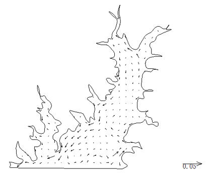
Figure 7. Flow field distribution of target reservoir under work condition 1
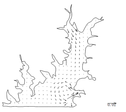
Figure 8. Flow field distribution of target reservoir under work condition 2
Inflow and outflow are main water movement forms in reservoirs. They control the migration and diffusion of pollutants in the reservoir through water body exchange. In cases that the water quality of lake reservoir has seriously deteriorated, ecological water transfer is considered to be an important means to improve the water environment of reservoir, this measure increases the water volume of inflow and outflow of reservoir using human intervention method, thus it’s particularly important to master the impact of the changes in the water volume of inflow and outflow on the flow field in the reservoir, only in this way, can the water volume of ecological water transfer be determined reasonably.
We designed two work conditions to study the impact of inflow/outflow on the flow field structure of Yazidang Reservoir. Under work condition 1: the inflow volume was 400,000 m3/d, the outflow volume was 400,000 m3/d; under work condition 2: the inflow volume was 400,000 m3/d, the outflow volume was 600,000 m3/d.
According to the simulation results, under both conditions, there’re obvious mainstream flows from the water inlet to the water intake tower, and the flow velocity increased with the increase of inflow water volume (Figure 7 and 8). When water was supplied, with the increase of inflow volume, the flow velocity values at each point of the reservoir area increased as well. Near the water inlet, the flow velocity reached 0.2~0.3 m/s, which then decreased gradually along the mainstream flow direction; Near the reservoir center, the flow velocity decreased to around 0.002~0.003 m/s. Near the water intake mouth, due to the action of water intake power, the flow velocity also reached about 0.2~0.3m/s. In the southwest area of the reservoir, the impact of mainstream flow and water intake was the smallest, therefore, the flow velocity was the lowest, only about 10-4~10-5m/s.
This paper constructed a 2D shallow water hydrodynamic model to simulate the flow field in the Yazidang Reservoir and study the impact of wind velocity, wind direction, and inflow/outflow on the flow field in the target reservoir, and attained the following conclusions:
(1) Wind is one of the most important factors affecting the flow field of the Yazidang Reservoir. Wind velocity has little impact on the flow field structure of the target reservoir; flow velocity is closely related to wind velocity; under the conditions of same wind velocity and opposite wind directions, circulations formed in the reservoir are similar but in opposite directions; after comparing several different wind directions, it’s found that circulations in the target reservoir show clockwise, counterclockwise, and transitional circulations.
(2) The inflow/outflow only have a certain impact on the area near the water inlet and outlet, and the range of this impact is related to the size of the water volume of inflow/outflow; under calm wind condition, the flow field in the target reservoir is determined solely by the inflow/outflow, and its impact on the area far from the inlet and outlet is very small.
Ningxia Natural Science Foundation (Grant No.: 2021AAC03176 and 2021AAC03195); High Level Talent Introduction Fund Project, North Minzu University; Ningxia Key Research and Development Plan (Talent Introduction) (Grant No.: 2018BEB04039). The Construction Project of First-Class Disciplines in Ningxia Higher Education (Grant No.: NXYLXK2017B09).
[1] Xu, X.F., Liu, Q.Q. (2009). Numerical study on the characteristics of wind-induced current in Taihu Lake. Chinese Journal of Hydrodynamics, 24(4): 512-518.
[2] Luo, L.C., Qin, B.Q. (2003). Numerical simulation based on a three-dimensional shallow-water hydrodynamic model in Lake Taihu-current circulations in Lake Taihu with prevailing wind-forcing. Journal of Hydrodynamics, Ser. A, 18(6): 686-691. https://doi.org/10.3969/j.issn.1000-4874.2003.06.003
[3] Han, L.X., Long, D.Y., Li, H.J., Zhang, D.M., Zhang, P. (2011). 3D numerical modeling of wind-driven flow in the high salinity Aibi Lake. Advances in Water Science, 22(1): 97-103.
[4] Simons, T. J. (1971). Development of numerical models of Lake Ontario. Proc. Conf. Great Lakes Res. IAGLR, 14: 654-669.
[5] Chinese Academy of Environmental Sciences Investigation and assessment of lake ecological security. Beijing: Science Press, 2012.
[6] Hu, W.P., Pu, P.M., Qin, B.Q. (1998). A three-dimensional numerical simulation on the dynamics in Taihu Lake, China (I): The water level and the current during the 9711 typhoon process. Journal of Lake Sciences, 10(4): 17-25.
[7] Hu, W.P., Pu, P.M., Qin, B.Q. (1998). A three-dimensional numerical simulation on the dynamics in Taihu Lake, China (II): The typical wind-driven current and its divergence. Journal of Lake Sciences, 10(4): 26-33.
[8] Hu, W., Qin, B., Pu, P. (2000). Three-dimensional Numerical Experiments on Hydrodynamics in Taihu Lake-3. Influence of the Reclaimation in Mashan District on Wind-driven Current. Journal of Lake Sciences, 12(4): 335-342. https://doi.org/10.18307/2000.0407
[9] Han, H.J., Hu, W.P., Jin, Y.Q. (2008). Numerical experiments on influence of wind speed on current in lake. Oceanologia Et Limnologia Sinica, 39(6): 567-576. https://doi.org/10.3321/j.issn:0029-814X.2008.06.005
[10] Zhang, F.B., Hu, W.P., Qin, B.Q. (2004). Numerical Analysis on Influence of Topography on Wind-driven Current in Lake. Journal of Hydraulic Engineering, 12: 34-38. https://doi.org/10.3321/j.issn:0559-9350.2004.12.006
[11] Jiang, H.Z., Cui, L., Shi, F., Liu, S.G., Liu, Z.H. (2013). Study on influences of wind field, topography and inflow/outflow on flow in lake Tai. J. Hydroelectr. Eng, 6: 165-171.
[12] Han, H., Hu, W., Jin, Y. (2007). Numerical experiments on the influences of inlet and outlet flow on lake current. Transactions of Oceanology and Limnology, (z1): 37-45. https://doi.org/10.3969/j.issn.1003-6482.2007.z1.006
[13] Zhang, T.F. (2007). Computational Fluid Dynamics. Dalian University of Technology Press.
[14] Hu, H.X., Luo, W., Wang, Q.H., Yang, J.Z., Zhang, X.Y., Li, Z.H., Zhang, X.H. (2021). Measurement of relative permeability curves of cores with different permeability and lengths under unsteady-state. International Journal of Heat and Technology, 39(1): 219-226. https://doi.org/10.18280/ijht.390124
[15] Chen, Z.H., Fang, H.W., Liu, B. (2007). Numerical simulation of wind-induced motion in suspended sediment transport. Journal of Hydrodynamics, 19(6): 698-704. https://doi.org/10.1016/S1001-6058(08)60006-2
[16] (GB3838-2002). National Standards of the People’s Republic of China. Environmental Quality Standard for surface water. Beijing: China Planning Publishing House.
[17] KOUTITASC,0'CONNORB. Modeling three-dimensional wind-induce flows. Jhydraulic Divispny ASCE, 1980, 10, 6(11): 1843-1865.