Soni Pratomo | Widya Fransiska Febriati Anwar* | Muhammad Sani Roychansyah
© 2026 The authors. This article is published by IIETA and is licensed under the CC BY 4.0 license (http://creativecommons.org/licenses/by/4.0/).
OPEN ACCESS
Jambi City, Indonesia, is a riverside city historically structured by the Batanghari River into northern and southern parts. The research adopts a qualitative method aided by GIS, utilizing historical map data that is analyzed through content analysis to trace morphological changes over time. This study examines Jambi's urban morphology by analyzing the evolution of its street systems, plot patterns, and building blocks from 1401 to 2025 through a diachronic Conzenian framework. Utilizing historical maps (1878–1945) and contemporary spatial imagery, the study traces spatial changes across four distinct periods: sultanate, Dutch colonial, post-independence, and contemporary hybridization. The analysis shows that the southern bank was transformed and declined after the port relocation in 1995, whereas the northern bank, Sekoja, remained stable with original plot arrangements and natural street layout intact. This physical connectedness is sustained by the continuous adaptation of traditional stilt-house typologies and spatial naming systems (Laut, Darat, Ulu, Ilir); this mediates current intervention. The findings demonstrate that Jambi's dual spatial structure is not a transitional anomaly but a stable, resilient condition. This offers a robust, empirically grounded foundation for river city planning that integrates historic town-plan anchors and reliable features rather than relying solely on administrative zoning.
adaptive urban river-morphology, Batanghari River, content analysis, Conzenian theory, dual morphology, Jambi City, morphological persistence, urban fallow
Rivers have historically been among the most powerful structuring forces in urban development and continue to shape the spatial logic of cities worldwide [1-3]. As complex ecological systems and primary transportation corridors, rivers have long influenced the location of settlements, the orientation of urban growth, and the configuration of street networks and built form [4, 5]. Within the geographical tradition of urban morphology, rivers often function as the primary 'morphological frame', providing a natural constraint that dictates the initial patterns of land conversion from rural to urban use [6]. In many historical Southeast Asian entrepôts, the waterway served as the arterial spine, establishing the first 'fixation lines' that guided the subsequent evolution of the town plan [6-8]. This river-oriented spatial logic creates a unique 'water and land dual-track' structure where streets and river networks collectively form the fundamental framework of the city.
In the contemporary era, however, a significant decoupling has occurred between many modern cities and their rivers. This transition is marked by a shift in orientation from water-based mobility to land-based infrastructure, fundamentally altering the city's spatial structure [9-12]. The prevalence of road networks has led to a process of 'morphological assimilation', where traditional river-oriented settlements are pushed into a transitional state, often resulting in spatial fragmentation and declining visual coherence [13]. Recent studies on historic water towns indicate a diminishing role of rivers in shaping urban riverscapes, often leading to a cycle of 'urban fallow' where original riverfront facades are relegated to secondary functional roles. This weakening relationship with the river is not merely a physical change but a transformation in the city's morphology that threatens spatial identity and collective memory [14, 15].
Despite these global transformations, current urban morphology research has yet to address these dynamics comprehensively, particularly within the Global South. A significant research gap exists because urban morphological studies—specifically those utilizing the Conzenian approach—have been predominantly conducted on inland European cities [16-18]. There is an evident 'Euro-American myopia' in the literature, leaving the morphological evolution of tropical river cities in Southeast Asia theoretically underdeveloped [12, 18, 19]. While general historical accounts of the region exist, there remains a critical shortage of multi-level typo-morphological analyzes that connect macro-urban layouts with micro-building characteristics. Most existing studies on Indonesian river cities [20-26] have relied heavily on socio-cultural or descriptive methods that fail to examine the diachronic connections between streets, plots, and building blocks [26]. Consequently, the mechanisms through which river-oriented morphology persists or transforms under intense land-based urbanization remain poorly articulated.
This research aims to address this gap by analyzing the persistence and transformation of the morphology of Jambi Old Town as a riverside urban form. Jambi City, spatially divided by the Batanghari River, represents a critical case of a historical river port city transitioning from a water-oriented sultanate to a land-oriented provincial capital. Adopting the Conzenian historico-geographical approach, this study systematically examines the 'tripartite division' of the town plan: (1) street systems, (2) plot patterns, and (3) building masses or blocks [25, 27]. By integrating historical maps from the Dutch colonial period with contemporary spatial imagery, the study traces the morphological trajectory of the Kawasan Kota Lama (Old Town Area) from the pre-colonial era to the present day. This approach allows for the identification of 'relic features' in the town plan that continue to act as long-term constraints on modern development [27].
The study provides several significant contributions to the field of urban morphology and planning. Primarily, it extends the application of Conzenian theory to the tropical riverine cities in Southeast Asia, demonstrating that morphological persistence is an adaptation to ecological and cultural 'frames' [27, 28]. Furthermore, the research advances a conceptual understanding of 'morphological sustainability' by linking the persistence of inherited forms to long-term functional and social vitality. The findings reveal how the historic town plan can persist despite a fundamental shift in the city's orientation from river to land [21, 22]. Ultimately, this research provides a diagnostic foundation for conservation and revitalization strategies that prioritize structural continuity and riverside spatial identity in rapidly urbanizing regions [29, 30].
Cities function as dynamic spatial systems continuously shaped by the interaction of physical form, temporal processes, and social practices [18, 31]. Everyday activities of urban residents actively contribute to transformations in spatial structure, while geographical and environmental conditions simultaneously constrain and enable these processes. To interrogate the relationship between urban communities and their lived spatial environments, particularly in relation to underlying geographical determinants, urban morphology has emerged as a critical analytical framework. Urban morphology examines the interdependence between physical dimensions of the city—such as geographical setting, environmental conditions, spatial structure, and urban patterns—and non-physical dimensions, including socio-economic processes, cultural practices, and political dynamics.
2.1 Urban morphology and the Conzenian tradition
Urban morphology is defined as the systematic study of the physical form of cities, focusing on the spatial structure and character of human settlements as they evolve [2, 32]. Within this field, cities function as dynamic adaptive systems shaped by the continuous interaction of physical form, temporal processes, and socio-cultural practices [16, 18]. The geographical–historical tradition, systematically articulated by M.R.G. Conzen in 1960, conceptualises the urban landscape as a 'palimpsest' of historical layers where inherited forms act as a constraint on subsequent change.
Central to the Conzenian approach is the 'tripartite division' of the townscape, which categorizes urban form into three fundamental element complexes: (1) the town plan or ground plan, consisting of the street system, plot pattern (land parcels), and building footprints; (2) the building fabric, representing the three-dimensional form; and (3) land and building utilization [27, 33]. Among these elements, the town plan is recognized as the most conservative morphological complex, often persisting for centuries as a 'morphological frame' that dictates the trajectory of urban growth even after the original socio-economic functions have vanished. This study prioritizes 'town-plan analysis' to detect how historical 'fixation lines'—physical or legal barriers such as riverbanks or colonial administrative boundaries—continue to structure the contemporary urban fabric of Jambi.
2.2 River-oriented urban development
Rivers constitute one of the most influential geographical determinants of urban morphology, functioning simultaneously as transportation corridors and spatial structuring elements [5]. In the pre-colonial era of maritime Southeast Asia, rivers were the 'givers of life' and the primary axis for trade, leading to the formation of water-oriented settlements [20-23]. These early urban configurations were characteristically shaped by a 'water and land dual-track' street system where the river network acted as the arterial spine for all movement and economic exchange.
However, the transition from water-based mobility to land-based infrastructure has fundamentally altered the spatial logic of river cities. Modernization, often initiated during the colonial period through the introduction of roads and railways, has led to a 'decoupling' of the city from its river [9-12]. This shift triggers a process of 'morphological assimilation', where traditional riverfront facades—originally the 'front door' of the city—are relegated to secondary functional roles or 'urban fallow' as development moves inland. In Indonesian contexts, this transition often results in the fragmentation of vernacular spatial structures, where organic riverine settlements must adapt to rigid, grid-based land transportation networks [22, 23].
2.3 Morphology of river cities: The dual structure
River cities frequently exhibit a 'dual urban structure', representing a spatial manifestation of the tension between traditional and modern urbanization. This duality is typically expressed through the coexistence of an organic, linear development following the river's curvature (traditional/vernacular bank) and a planned, geometric layout oriented towards inland roads (colonial/modern bank). Despite the global prevalence of this phenomenon, morphological analysis of river cities remains limited, particularly in tropical regions where environmental factors such as seasonal flooding necessitate specific adaptations, such as stilt house typologies [21-23, 26, 33].
A critical gap exists in the literature regarding diachronic and multi-level typo-morphological studies that connect macro-urban layouts with micro-building characteristics in Southeast Asian entrepôts. Jambi City provides a compelling empirical context for addressing this gap. Divided by the Batanghari River—the longest in Sumatra—Jambi represents a transition from a 15th-century sultanate to a 20th-century Dutch residency and subsequently a modern provincial capital [27, 28]. The persistence of 'Pelayangan' (traditional river-crossing points) and the 'Rumah Panggung' (stilt house) typology in Jambi Kota Seberang, despite intense land-based urbanization on the southern bank, offers a unique opportunity to theorize how urban form maintains its structural identity through environmental and cultural attachments. Analyzing Jambi's morphology thus contributes to a broader understanding of 'morphological sustainability' and the resilience of historic water-oriented urbanism in the Global South.
2.4 Incremental contribution and comparative context
Table 1 distinguishes this study from previous morphological and spatial investigations of Jambi City. Research on the urban morphology of Jambi remains limited; however, from this limited body of research, it can be seen that the variables observed in previous studies include buildings, land parcels and transport networks. In addition, there are observations regarding elements of the urban landscape, such as roads, junctions, edges, districts and landmarks. The urban morphology of Jambi also includes the variable of urban elements, such as the port, which forms part of the city’s development itself.
Table 1. Jambi City previous study (analysis, 2025)
|
Prior Study |
Study Area |
Temporal Scope |
Analytical Unit |
Method |
Findings |
Incremental Contribution of This Study |
|
[20] |
Pasar Jambi (Southern) |
Colonial-2025 |
Land use, building mass (shophouse), circulation |
Drone image, qualitative descriptive analysis |
The shift to land-based transportation cuts the city off from the river; the relocation of the port and the relocation of the market led to urban decline. |
Conceptualizes "decoupling" within Conzen's "morphological frame" and "fringe-belt" theory, examining the tropical burgage cycle. |
|
[34] |
Pasar Jambi and riverbank (Southern) |
2023 |
Contextual features, functions and meanings |
Qualitative, based on the constructivist perspective |
Area development based on familiarity and distinctiveness |
Understanding place attachment in riverside towns |
|
[25] |
Olak Kemang District (Northern) |
Early 2020s |
Street networks, plot boundaries, and stilt-house typology |
Qualitative direct observation and literature review |
Road network is organic, determined by gaps between stilt houses; spatial orientation operates via river-relative coordinates. |
Enhancing descriptive findings by applying georeferencing to historical data layers within a GIS to assess the physical continuity of land parcels and roads |
|
[24] |
Jambi Kota Seberang Cultural Heritage Area (Northern) |
Pre-colonial-2019 |
Land use, place, landmark, open space, figure-ground and historical events |
Diachronic description interpretation of the urban elements |
Organic growth shaped by geography, trade, and Islam; unpatterned linear form. |
Integrates both banks into a single dual-structured morphological system, analyzing their spatial-functional interactions. |
|
This study |
Jambi Old Town (North and South banks) |
1401–2025 |
Conzenian tripartite division (streets, plots, building blocks) and cognitive coordinates |
Diachronic GIS-based multi-temporal town-map overlay, cartographic digitisation, and staged coding |
The river functions as an active morphogenetic framework, establishing fixation lines that dictate the persistence of the dual structure. |
Provides a unified, replicable spatial analysis framework that bridges terrestrial Conzenian theory with tropical riverine dynamics. |
This research differs from existing studies, which have mostly focused on single-bank qualitative descriptions, contemporary tourism mapping or isolated analyzes of economic decline on the southern bank, by adopting a unified, diachronic Conzenian framework across both banks of Jambi Old Town over a long period spanning 1401–2025. Based on the literature review that has been conducted, the variables to be examined are land parcels, buildings and transport infrastructure. Given that the focus and location of the research are on the riverbanks, elements characteristic of a river city will also be examined.
The incremental contribution of this study is threefold. First, it moves beyond single-bank descriptions to conceptualize Jambi Old Town as a unified, dual-structured morphological system divided yet mediated by the Batanghari River. Second, it advances the methodological rigor of Jambi studies by shifting from qualitative narratives to a systematic GIS-based diachronic overlay using historical cartographic standardization with stable morphological anchors; and lastly concept mediates between terrestrial and tropical perspectives by adopting morphological sustainability-the durability of water-based plans, their vocabularies, and the role they play in urban development today.
2.5 Theoretical synthesis: Towards an integrative model of riverside morphological persistence
The convergence of Conzenian historico-geographical principles with the socio-environmental dynamics of tropical riverine systems establishes a robust meta-framework for integrative urban morphology. This study conceptualizes the river as a dynamic, evolving framework that shapes both the physical and mental structures of the city, rather than just being a static natural boundary. The dialectical tension between the organic, water-oriented vernacular bank and the highly rationalized, land-oriented colonial grid illustrates how the classical tripartite division (street, plot, and building fabric) undergoes a profound spatial-functional divergence when confronted with modern terrestrial infrastructure.
Consequently, 'morphological persistence' in this context is redefined as a multi-dimensional, adaptive phenomenon. The concept extends beyond the physical structural inertia of infrastructure, incorporating local spatial cosmology and traditional architectural styles, such as the ongoing use of directional terms including Laut, Darat, Ulu, and Ilir, and vernacular types like Rumah Panggung, which adapt and mediate changing environmental circumstances and the influence of modernization. The theory offers a comprehensive framework that links separate concepts, thereby bridging the gap and facilitating a thorough evaluation of 'morphological sustainability' in Global South regions by demonstrating how historic water-based urban structures can operate effectively while preserving their original integrity without necessitating a complete transformation into earth-based systems.
3.1 Geographical setting and the Batanghari River
Jambi City has a long and continuous history. According to Regional Regulation No. 3 of 2014, the city was founded in 1401, when initial settlements began on the banks of the Batanghari River. Originally known as Tanah Pilih, it serves as a vital economic and cultural centre in Sumatra [35] and is located in a lowland basin with elevations ranging from 0 to 60 metres above sea level. The city's geography is essentially shaped by the Batanghari River, in addition to nine tributaries, the Batanghari River also contains Lake Sipin, an oxbow lake. This navigable waterway has historically served as the city's primary 'morphological framework', acting as a backbone for regional and international trade connecting the interior of Sumatra to the Strait of Malacca. The climate is categorized as tropical rainforest, characterized by consistent warmth and high humidity.
As a city crossed by rivers and part of trade routes, Jambi City has a port serving it. Since the time of the sultanate, there has been a fairly busy port. The Dutch then built a modern port around 1920 [21]. City and government facilities during the Dutch occupation include the Residents' house and office, schools, hospitals, and a post office.
3.2 Spatial division: Pasar Jambi and Jambi Kota Seberang
The Batanghari River effectively divides Jambi's historic core into two distinct morphological parts: the southern bank, known as Pasar Jambi, and the northern bank, known as Jambi Kota Seberang. This configuration features a dual urban structure, in which the south bank has developed into a dense commercial area, established according to a colonial grid system, as opposed to the north bank, which retains a traditional, organic linear pattern with extensive stilt-house settlements. Connectivity between these sectors was traditionally sustained through boat crossings called Pelayangan, a significant morphological element that has helped maintain local mobility, although its importance has been gradually dwindling.
3.3 Historical morphogenesis
The morphogenesis of Jambi City can be categorized into four main parts, namely:
3.3.1 Early river-oriented settlement: The sultanate period (ca. 1401–1904)
Jambi City's history began with the opening of its first settlement in 1401, which marks the city's anniversary. This settlement was located in an area known as Tanah Pilih, on the banks of the Batanghari River.
3.3.2 Colonial morphological transformation period (1904–1945)
The Dutch occupation began in 1904, marked by the death of Sultan Thaha. During this period, the Dutch introduced land-based urban planning. Government and military buildings, as well as urban infrastructure, began to be constructed. During this period, the Japanese invaded Indonesia, including Jambi. Buildings erected by the Dutch were also later utilized by the Japanese, such as the Resident's Office, which also served as a Japanese military office.
3.3.3 The independence: Spatial reorientation (1945–1957)
This period marked the beginning of Indonesian independence and the establishment of Jambi Province in 1957. Development during this period did not experience significant morphological changes, although landward development intensified.
3.3.4 Contemporary morphological hybridization (1957–recent)
During this period, development accelerated considerably. The center of government, originally located in the Jambi Market area, was moved to Telanai Pura, along with the construction of housing for Jambi Provincial government employees. During this period, extensive riverside development took place, which included the moving of the Angso Duo Market and the WTC Mall, and the building of the Gentala Arasy bridge and tower, as well as a new inspection road along the Batanghari River.
This categorization is based on key milestones in the history of the city of Jambi, namely the city's anniversary (1401), the death of Sultan Thaha (1904), Indonesian independence (1945) and the establishment of Jambi Province (1957). For each periodization, there are several criteria taken into account, such as political changes, infrastructure development, centers of government and morphological changes. A brief overview is provided in Table 2 below.
Table 2. Periodization criteria
|
|
Political Change |
Infrastructure Development |
Administrative Relocation |
Turning Points |
|
Sultanate |
first settlement |
lack of street |
sultanate palace |
the burning palace |
|
Dutch |
colonial era |
new grid structure |
colonial office |
new infrastructure |
|
Independence |
independence era |
maintain structure |
governor office |
old structure |
|
Post independence |
independence era |
double layer street |
new office location |
new riverbank |
3.4 Relic features and identity
Despite experiencing intensive urbanization, Jambi's Old Town—particularly in the Jambi Kota Seberang area—demonstrates morphological persistence. Residential areas in Jambi Kota Seberang are dominated by wooden stilt houses whose long axes face east and west to reduce solar heat while remaining oriented toward the river. The community maintains a specific spatial nomenclature relative to the river: 'Laut' (toward the river), 'Darat' (away from the river), 'Ulu' (upstream), and 'Eler' (downstream). These terms, which serve as cosmological directional markers, are also used in naming places such as Kasang Darat, Mudung Laut, Tanjung Pinang, Sungai Putri, or Sungai Kambang. These elements, along with historical buildings such as the Stone House and the Al-Ihsaniyah Mosque, define the unique character of the riverside urban area.
This study investigates the urban morphology of the riverside city through a case study of the Jambi Old Town. The delineation of the study area is not based on contemporary administrative boundaries but rather on a morphological interpretation of historical cartographic sources overlaid with satellite imagery. This approach allows the study area to reflect the historically constituted urban form rather than current administrative divisions. The resulting boundary of the study area is presented in Figure 1.
Figure 1. Research area (private collection, 2008)
The research is guided by the central question of how the urban morphology of Jambi City has manifested and evolved as a riverside urban form over time. The primary objective is to analyze changes and continuities in the morphological structure of the Jambi Old Town by examining historical interactions among physical urban elements, spatial functions, and processes of urban development. Empirical observation and spatial analysis focus on two principal areas: the Pasar Jambi area on the southern bank of the Batanghari River and Olak Kemang in Jambi Kota Seberang on the northern bank.
4.1 Data sources
This study utilizes a multi-temporal dataset to trace the morphological evolution of Jambi Old Town. The data were obtained from various international and national archives to ensure a comprehensive diachronic analysis. The selection of temporal benchmarks follows the 'morphological period' principle, identifying key stages of administrative and infrastructure change.
The primary data sources are categorized as follows:
•Historical Cartographic Materials
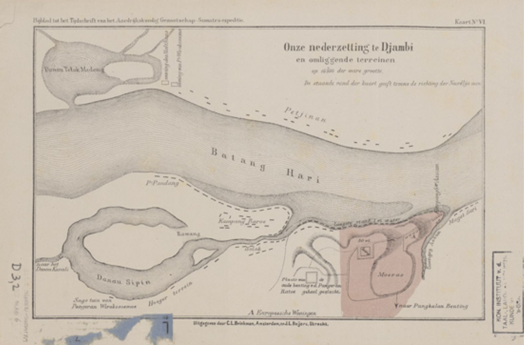
1878 Map: Sourced from the Royal Netherlands Institute of Southeast Asian and Caribbean Studies (KITLV) in Leiden, capturing the pre-colonial sultanate settlement patterns
1887 Map: Sourced from the Royal Netherlands Institute of Southeast Asian and Caribbean Studies (KITLV) in Leiden, illustrating early colonial military and economic interests
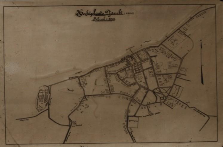
1923 Map: Sourced from the Royal Netherlands Institute of Southeast Asian and Caribbean Studies (KITLV) in Leiden, showing the consolidation of the Dutch Residency layout
1945 Map: The primary cartographic reference for delineating the study area. Obtained from the National Library of Australia, representing the critical urban structure prior to major post-independence transformations. This map represents a critical temporal benchmark, capturing the urban structure before major post-independence transformations.
•Modern Spatial Data
2008 AutoCAD Base Map: Used as the primary geometric reference framework for contemporary urban features.
Satellite Imagery (2002, 2008, 2025): High-resolution imagery from Google Earth Pro and Apple Map used to validate recent transformations in building blocks and land use.
•Archival and Field Data
Documents from Spatial Planning
Field observations conducted between 2022 and 2026 to document relic architectural forms (Rumah Panggung, Pelayangan, colonial building) and communal plot boundaries.
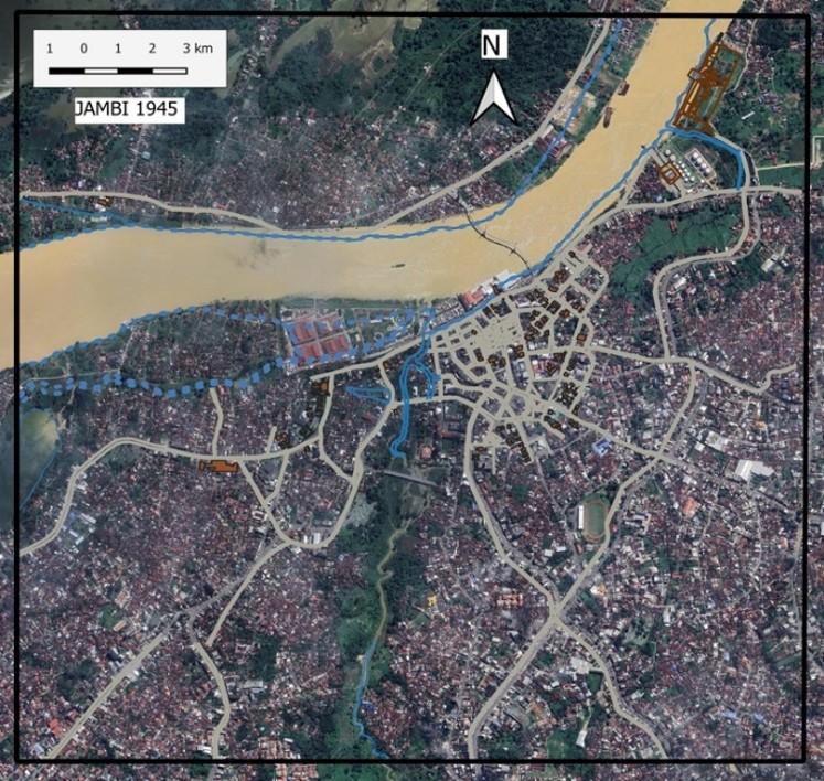
Figure 2 shows the maps used for the analysis in this study. Figure 2(a) is a map from 1945, an older map that is representative enough to be redrawn. Figure 2(b)–2(d), meanwhile, are Google Earth Pro satellite images used to compare riverbank conditions; these images were not redrawn as the Google Earth Pro application already provides a line map mode.

4.2 Methods
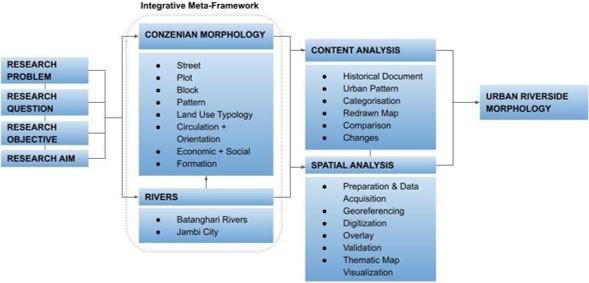
The research employs a qualitative integrative approach based on Conzenian 'town-plan analysis' aided by GIS. To ensure methodological rigor and replicability, the analysis followed a systematic five-stage procedure.
Digitization and Redrawing: Historical maps were redrawn in GIS and AutoCAD to ensure high-precision representation. High-precision cartographic materials with a minimum scale equivalent to 1:2500 are required to ensure adequate representation of morphological elements such as street systems, plot patterns, and building blocks [27, 29]. The results of map redrawing and content analysis are presented in Figure 3.
Figure 3. Map redrawn (Analysis, 2025)
Geometric Standardization: Maps were drawn using QGIS and the 2008 AutoCAD map as a reference. Georeferencing was achieved through 'morphological anchors'—stable benchmark points such as the Water Tower (Plumbing Office) at X = 11,533,531.74 Y = -177,574.11, the Governor’s Residence at X = 11,534,724.30 Y = -176,819.17, Junior High School 1 at X = 11,534,697.76 Y = -177,264.54 and Magatsari Mosque at X = 11,534,351.82 Y = -177,085.97 —which exhibit long-term spatial persistence. Given the limited accuracy and incomplete georeferencing of early historical maps (1878 and 1887 maps), the redrawing process does not seek exact cartographic precision. Rather, it aims to produce methodologically consistent and analytically robust representations that closely approximate actual spatial conditions and are suitable for historico-geographical morphological analysis.
Identification of Morphological Elements: The urban fabric was deconstructed into the Conzenian 'tripartite division': (i) street systems, including waterways and railway alignments; (ii) plot patterns or plan units; and (iii) building masses or blocks [27, 36].
Spatial Overlay and Change Detection: Multi-temporal maps were superimposed to detect continuities and transformations. This stage involves the identification of 'fixation lines' and 'relic features' in the town plan that remain consistent across different morphological periods. The oldest map of good cartographic quality is the 1945 map. This map was redrawn using QGIS and then overlaid onto a high-resolution satellite image used in the morphological development analysis.
Interpretative Content Analysis: The codification process involved a content analysis of the available maps. The content analysis examined plots, streets and blocks as units of analysis. The content analysis begins with the map as a whole and then examines the map in smaller sections. Patterns of persistence were synthesized through a staged coding process. Open coding identified individual components, axial coding examined their spatial interactions (e.g., orientation to river vs road), and selective coding articulated the final narrative of morphological sustainability and adaptation. This method is applied not only to textual documents and historical photographs [9] but also to cartographic materials and satellite imagery.
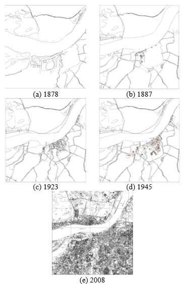
Figures 3(a)–(d) show old maps from 1878, 1887, 1923 and 1945 that have been redrawn using AutoCAD. The 2008 map is from a private collection and was calibrated at the time of its creation in that year. The overall research workflow is summarized in Figure 4.
Figure 4. Research workflow (analysis, 2026)
5.1 Results
5.1.1 Early river-oriented settlement: The sultanate period (ca. 1401-1904)
Jambi City exhibits a long and continuous historical trajectory, originating from a civilization defined by river access. According to Regional Regulation No. 3 of 2014, the city was founded in 1401, when early settlement was initiated along the banks of the Batanghari River [27]. During this formative phase, the river functions as the primary 'morphological frame', dictating a linear growth pattern where the Residence of Pangeran Ratu served as the principal urban node (Figure 5). This residence emerged as a new centre following an earlier settlement located to the north-west, known as Tanah Pilih Pusako Betuah [27]. This pattern aligns with river-oriented urban development models identified in previous studies [4, 5, 37].
Urban growth developed organically along both the southern and northern banks, following the river's course as the primary transportation and trade corridor [28-30]. The spatial logic was entirely water-oriented, consistent with Southeast Asian river port models where the waterway acts as the city's 'front door' for economic exchange [5, 10, 36]. Content analysis of the 1878 map (Figure 5) reveals that areas such as Telanai Pura and Pandan Island were originally sago plantations belonging to the Jambi Sultanate, reflecting an integrated agrarian-maritime settlement structure.
5.1.2 Colonial morphological transformation period (1904-1945)
The Dutch occupation began in 1906, following the defeat of Sultan Thaha in 1904, marking a fundamental shift in Jambi's urban development. The establishment of the Jambi Residency in 1906 introduced formal land-based planning principles that created a 'dual urban structure'. On the southern bank, the Dutch introduced the first land-based 'fixation lines' through a regularized geometric layout, including grid systems extending perpendicular to the river.
Key urban structures introduced during this period—acting as enduring 'morphological anchors'—include the Water Tower (Plumbing Office), port facilities, the Landraad building, hospitals, and schools, as recorded on the 1923 (Figure 6) and 1945 maps. The colonial administration reorganized ethnic settlements into clusters, concentrating Europeans and elite officials on higher land to avoid seasonal flooding, while noble families (Pangeran/ Prince Wirokusumo) were restricted to specific zones on the northern bank. This era established the foundational town plan for what is now Jambi's historic commercial core.
5.1.3 Post independence: Spatial reorientation (1945–1957)
Subsequent morphological consolidation is evident in the 1945 map, particularly on the southern bank of the Batanghari River, later known as the Pasar Jambi area. During this phase, more regularized block and plot systems emerged, accompanied by the construction of public buildings associated with colonial administration. Street structures continued to follow the river's alignment but also began to form perpendicular grid patterns extending inland. This configuration reflects intensified commercial activity and the functional expansion of port-related urban areas. The eastward and southward extension of street networks indicates an emerging shift in spatial orientation away from the river towards inland areas. In contrast, the northern bank, later known as Jambi Kota Seberang, remains predominantly residential—a condition that has persisted with relatively limited transformation to the present day [35]. The urban structure of Jambi Kota Seberang developed in an organic manner [26], characterized by stilt houses and indistinct plot boundaries. These characteristics illustrate a clear instance of morphological persistence in spatial structure despite changes in land-use function.
5.1.4 Contemporary morphological hybridization (1957–recent)
The current urban morphology of Jambi represents a hybrid state where relic traditional forms coexist with large-scale modern infrastructure. A significant 'morphological decoupling' occurred in the late 1960s and early 1970s with the relocation of the provincial government center to Telanai Pura. This relocation shifted the city's administrative weight inland, behind Lake Sipin, effectively relegating the Batanghari riverfront to a secondary functional role. Although this new administrative center remained relatively close to the river, it was positioned on the southern side of Lake Sipin, an oxbow lake formed from a meander of the Batanghari River. This geomorphological process also produced a land mass known as Pandan Island. Content analysis of an 1878 historical map reveals that both the Telanai Pura area and Pandan Island were originally sago plantations belonging to the Jambi Sultanate which subsequently developed into residential areas and shrubland.
During the late 1960s and early 1970s, the Great Mosque of Al Falah was constructed on the former Dutch military complex, marking a significant reconfiguration of institutional land use within the historic urban core. In 1995, Jambi Port was relocated to Talang Duku, signaling a further shift in river-based economic activity and removing the functional traces of the river port city identity. In addition, sedimentation in the Batanghari River between the Solok Sipin tributary and the Asam River led to the development of the Angso Duo Main Market in the mid-1970s.
Subsequent rapid urban development intensified transformations in riverside spaces. Increased sedimentation prompted land reclamation around the Angso Duo Main Market area, coinciding with the relocation of port activities. This sedimentation process also transformed the former inspection road—originally constructed during the Dutch period—into a double-layered roadway extending from the New Angso Duo Market area to Tanggo Rajo. While recent interventions reflect a growing awareness of sustainability and river–land spatial legitimacy, as seen in the development of the Putri Pinang Masak public open space, contrasting conditions are introduced by large-scale developments such as the Batanghari World Trade Centre. Visual access and continuity play a critical role in shaping public perception and experience of riverside urban landscapes [10, 14], and their disruption represents a key morphological challenge in the contemporary period.
5.2 Discussion
5.2.1 River as morphogenetic structure
The Batanghari River is not merely a geographic backdrop but the primary 'morphological frame' that has dictated the spatial logic of Jambi for over six centuries. The Batanghari River constitutes a fundamental structuring element in the formation and long-term development of the Jambi Old Town, more broadly, Jambi City as a whole, thereby justifying its characterization as a river city [38]. Beyond its role as a transportation corridor, the river has functioned as a residential environment for floating houses, an orienting axis for spatial organization, and a core arena of everyday community life. As a conduit linking the external world to the port as a center of cultural interaction, the river has facilitated continuous cultural exchange, often producing hybrid cultural forms whose origins are difficult to disentangle [33]. In this sense, the river operates as a key generator of urban identity, acting in conjunction with social, cultural, and historical processes rather than merely as a physical landscape feature [38].
Within this context, the Batanghari River can be understood as an agent of morphogenesis, borrowing a concept from biology to describe formative processes through which spatial structures emerge and evolve. Similar to river cities such as Florence [35], Suzhou [19], and Bangkok [36], the river in Jambi has generated a layered system of spatial hierarchy over time. In the Old City of Jambi, the river functions not only as an orienting element but also as an active ecological factor. Rivers contribute to urban development by providing essential ecosystem services through both the river channel and its wider watershed [3] as in Jambi, where the river serves as a source of livelihood and a means of transport.
Morphological change in Jambi has therefore emerged through continuous negotiation between government interventions and community practices, including the utilization of riverbank sedimentation, the construction of embankments, and the appropriation of river meanders as new urban spaces. These processes have reshaped the urban morphology of the Jambi Old Town by enabling the formation of new inspection roads on reclaimed sediment land, signaling a transition from a linear river city to a double-level street structure [4]. Sedimentation and erosion can be analyzed by observing shifts in the riverbank, as shown in Figure 7. The blue lines on the map show the condition of the riverbanks as depicted on maps from 1923 and 1945. This image shows the riverbank in those maps, which differ from the current satellite imagery from recent years.
In the Conzenian tradition, this frame exerted a powerful long-term constraint on subsequent changes, where the river's curvature established the initial 'fixation lines' that guided the alignment of early street systems and building footprints. Beyond its role as a transportation corridor, the river acts as an active agent of morphogenesis, facilitating a layered system of spatial hierarchy similar to those observed in other historical river cities. The transition from a purely water-oriented enterprise to a land-oriented administrative center illustrates how the river continues to structure urban growth through ecological and infrastructure negotiations, such as land reclamation and the formation of double-layered roadways on sedimentary land.
Figure 7. Batanghari River course (analysis, 2025)
5.2.2 Jambi dual morphology
The morphological evolution of Jambi reveals a pronounced 'Dual-City' characteristic, reflecting the divergent spatial ideologies of the pre-colonial sultanate and the Dutch colonial administration. The opposing aspects are represented in the contrasting personalities of the two riverbanks. The northern bank exhibits significant structural stability, characterized by an organic, linear pattern of spaces between vernacular stilt houses (Rumah Panggung) that form the movement network rather than traditional planning. In contrast, the southern bank, known as Pasar Jambi, exemplifies the impact of colonial modernization, which saw the Dutch impose a standardized grid-based layout and introduce architectural features such as the Water Tower and the Landraad building to consolidate administrative control. The city's duality constitutes a defining feature of Jambi's urban identity, with two distinct spatial systems coexisting within a single entity mediated by the river. Older spatial configurations continue to be absorbed, negotiated, and maintained alongside newer development patterns that are increasingly oriented away from the historic river-based core [28].
As a city adapted to riverine conditions, ports and docks form integral components of the morphological trajectory of the Jambi Old Town. Waterfront cities commonly exhibit ports as key morphological anchors within their historic cores [30], as illustrated by Tuban, where the port remains embedded within the old city structure. Morphological duality means that both riverbanks developed as river-oriented urban areas, with connectivity and interaction facilitated through river crossings locally known as Pelayangan. These crossings continue to operate today, although their functional significance has declined following the construction of the Aur Duri Bridge. Since the bridge's completion, reliance on docks and services as primary modes of transportation has diminished. Nevertheless, Pelayangan has persisted as a toponym and afterwards as the name of a subdistrict in Jambi Kota Seberang, indicating the enduring cultural imprint of river-based mobility within the urban landscape.
5.2.3 Morphological persistence and urban transformation
Despite the intense pressures of post-independence urbanization and the shift toward land-based mobility, Jambi Old Town exhibits remarkable morphological persistence. This persistence is most evident in the ground plan, which remains the most conservative element of the urban landscape, retaining historical grain even as building materials transition from timber to concrete. Furthermore, the river remains embedded in the collective memory and spatial cosmology of the residents. The continued use of river-based nomenclature—Laut (toward the river), Darat (inland), Ulu (upstream), and Ilir (downstream)—demonstrates an intangible form of persistence that maintains the city's riverside spatial legitimacy. Water-related terminology also permeates local toponyms and spatial cosmology, further reinforcing the cultural embeddedness of the river within urban morphology. Place names such as Ulu Gedong, Sungai Marem, Sungai Sawang, Mudung Darat, Mudung Laut, Kasang Darat, Kasang Laut, Tanjung Raden, and Tanjung Pinang reflect a spatial logic structured by water. The persistence of this river-based spatial vocabulary underscores the depth to which river morphology continues to shape spatial perception, orientation, and urban identity in Jambi City.
However, modern infrastructure projects like the WTC Mall, the Gentala Arasy Bridge and the revitalization of Angso Duo Market pose challenges of 'architectural incongruence', risk of 'urban fallow', and potential loss of visual coherence. As a riverside urban landscape, the unity of river and land is not only physical but also visual [10, 14]. Recognizing these relic features is crucial for developing conservation strategies that ensure 'morphological sustainability' while allowing for necessary functional transformations in the contemporary era.
The findings of this research demonstrate that the morphology of a riverbank city, as exemplified by the Jambi Old Town, has evolved through layered growth and transformation. The city developed from an organically water-oriented urban form into a hybrid water–land city constructed upon an inherited ecological substrate. This evolutionary pattern reflects continuous adaptation between natural space, built structures, and social conditions. However, in certain phases, this process has also produced morphological defects, manifested in urban structures that are less accommodating to the riverbank environment.
Content analysis further reveals that the growth of the Jambi Old Town is fundamentally rooted in river dynamics. These dynamics include sedimentation processes, land reclamation, shifts in river–land orientation, and human interventions, all of which have contributed to the emergence of morphological duality within the urban structure. The city transitioned from an organic, water-oriented entity to a hybrid water-land urban form, a process that reflects a continuous negotiation between natural constraints and socio-political interventions. This evolutionary trajectory also managed to survive a 'morphological flaw', whereby the modern urban structure accommodated the fluvial dynamics inherent in the Batanghari Riverbanks.
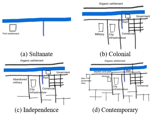
The investigation identifies four principal morphological layers shaping the development of Jambi City (Figure 8).
6.1 Early river-oriented settlement: The sultanate period (ca. 1401–1904)
This foundational layer exhibits a linear and an organic urban pattern, with the primary spatial axis aligned with the flow of the Batanghari River, which functions as the primary 'morphological frame' and spatial axis. Settlement development during this period was strongly river-oriented, reflecting dependence on water-based transportation, trade, and daily activities. The structure was characterized by a loose 'grain' of vernacular clusters, where the river served as the 'front door' of the city.
6.2 Colonial morphological transformation period (1904–1945)
Urban development during this phase became increasingly centered on governmental and economic functions, introducing formal land-based 'fixation lines' through the construction of a geometric road network and administrative infrastructure. A distinct 'dual urban structure' emerged: on the northern riverbank, the organic traditional settlement fabric persisted within community residential areas. In contrast, the southern riverbank experienced more planned development, as indicated by the construction of ports, a water tower, residential buildings, hospitals, schools, and other public facilities, as well as new settlement areas that continue to shape the contemporary commercial core.
6.3 The independence: Spatial reorientation (1945–1957)
This period is characterised by a 'morphological decoupling', a gradual shift in spatial orientation from the river toward inland areas. Outward expansion began during this period, and on the Jambi Kota Seberang side, there have been no changes to the road layout. Nevertheless, progress during this period has not yet been particularly significant.
6.4 Contemporary morphological hybridization (1957–recent)
At the beginning of this period, the following occurred marked by the construction of the Provincial Government complex in Telanai Pura. This development was complemented by residential complexes for government officials in Setia Negara. Despite this inland shift, the city did not maintain its relationship with the river; instead, it maintained historical hydrological connections through its orientation towards Sipin Lake, an oxbow lake formed by a meander of the Batanghari River, demonstrating the persistent influence of the water system even as land-based mobility became dominant.
The most recent layer reflects the hybridization of inherited urban structures with rapid urbanization processes. This phase is characterized by extensive riverbank reclamation and functional transformation of key urban spaces. A hybrid state characterized by intense land reclamation and the transformation of the riverfront from a functional facade into a symbolic or recreational landscape. During this period, the Angso Duo Market area transformed green open space, alongside continued reclamation and redevelopment of riverbank zones. The Gentala Arasy Bridge attempts to reintegrate the river into the urban experience; they often coexist with signs of 'urban decline' and 'urban fallow' in the older commercial areas, highlighting the challenges of maintaining morphological sustainability in a rapidly transforming riverside city.
The stages of morphological development are briefly illustrated in Figure 8, which shows the development of the Sultanate period Figure 8(a), the Colonial Morphological Transformation Figure 8(b), the Independence period Figure 8(c) and Contemporary Morphological Hybridization Figure 8(d).
The identification of four distinct morphogenetic layers confirms that Jambi City represents an adaptive riverine landscape where urban form persists through a continuous negotiation between inherited traditions and modernizing pressures. The findings demonstrate that the Batanghari River functions not merely as a geographical border, but as the primary 'morphological frame' that actively dictates the city's spatial logic and collective identity.
Theoretically, this study advances the Conzenian tradition by extending its analytical framework to include tropical rivers as primary agents of morphogenesis. By conceptualizing the river as an integral component of the town plan—structuring fixation lines and plan units—this research bridges the gap between terrestrial colonial urbanism and historic water-oriented urbanism. Jambi provides a compelling model for 'morphological sustainability', illustrating how structural duality across riverbanks can remain a stable urban condition rather than a transitional anomaly.
From a planning perspective, the findings advocate for an approach that prioritizes morphological continuity and ecological sensitivity. Recognizing 'morphological anchors' and 'relic features' provides a more robust foundation for heritage conservation than administrative zoning alone. Future planning strategies must account for the persistent fluvial dynamics of the Batanghari to mitigate 'architectural incongruence' and revitalize areas facing 'urban decline'. Ultimately, this research highlights that sustainable river town development depends on integrating historical spatial knowledge into future urban design frameworks.
Finally, this research opens pathways for further studies on riverbank city resilience, the application of spatio-temporal analytical methods to anticipate future morphological trajectories, and the formulation of morphology-based design and planning guidelines. Such directions are essential for integrating urban morphological knowledge into sustainable planning practices for river cities facing increasing environmental and developmental pressures.
[1] Tadaki, M., Brierley, G., Cullum, C. (2014). River classification: Theory, practice, politics. Wiley Interdisciplinary Reviews: Water, 1(4): 349-367. https://doi.org/10.1002/wat2.1026
[2] Grimm, N.B., Faeth, S.H., Golubiewski, N.E., et al. (2008). Global change and the ecology of cities. Science, 319(5864): 756-760. https://doi.org/10.1126/science.1150195
[3] Huang, Y., Wang, D. (2024). Study on the function and planning of urban river ecological corridor. The Global Environmental Engineers, 11: 1-12. https://doi.org/10.15377/2410-3624.2024.11.1
[4] Pattacini, L. (2021). Urban design and rivers: A critical review of theories devising planning and design concepts to define riverside urbanity. Sustainability, 13(13): 7039. https://doi.org/10.3390/su13137039
[5] Mosler, S. (2021). The transformative role of rivers in the evolution of urban landscapes: A case study from urban rivers of Chelmsford in Essex. Journal of Urban Design, 26(1): 95-116. https://doi.org/10.1080/13574809.2020.1835466
[6] Widodo, J. (2004). The Boat and the City: Chinese Diaspora and the Architecture of Southeast Asian Coastal Cities. Singapore: Chinese Heritage Centre.
[7] Sun, Y., Wu, Y., Yu, H., Li, Y. (2024). Spatiotemporal evolution of urban landscapes in Chinese historic water towns (1918–2021). Landscape Research, 49(4): 568-583. https://doi.org/10.1080/01426397.2024.2322138
[8] Huang, Y., Shi, Z., Chen, Y., et al. (2025). Urban form evolution and transformation of traditional water towns based on space syntax and GIS: Evidence from ancient Wenzhou city (16th to the 20th century). Frontiers in Earth Science, 13: 1520643. https://doi.org/10.3389/feart.2025.1520643
[9] Scott, A.J., Carter, C., Reed, M.R., et al. (2013). Disintegrated development at the rural–urban fringe: Re-connecting spatial planning theory and practice. Progress in Planning, 83: 1-52. https://doi.org/10.1016/j.progress.2012.09.001
[10] Rozaly, M.Z.M., Shukri, S.M., Latip, N.S.A., Abdullah, A. (2018). Reweaving the urban fabric of the historic riverfront townscape of Masjid India, Kuala Lumpur. International Journal of Engineering and Technology, 7(3.9): 81-85. https://doi.org/10.14419/ijet.v7i3.9.15282
[11] Dempsey, N., Velarde, C.M., Samuel, M., Bakshi, Y., Baradi, M. (2020). From river to riverfront: How meanings and cultural heritage change. The case of the Sabarmati Riverfront project, Ahmedabad, Gujarat. Town Planning Review, 91(6): 643-666. https://doi.org/10.3828/tpr.2020.89
[12] Wei, W., Liu, L., Niu, Z., Li, H. (2025). An approach for heritage settlement classification using block patterns: The study of 37 typical colonial heritage settlements in the Americas. Frontiers of Architectural Research, 14(4): 983-1000. https://doi.org/10.1016/j.foar.2024.12.001
[13] Whitehand, J.W.R. (2021). Conzenian research in practice. In Morphological Research in Planning, Urban Design and Architecture, pp. 19-42. https://doi.org/10.1007/978-3-030-66460-2_2
[14] Musa, R.M. (2025). Accessibility as a method of measuring urban legibility. International Journal of Sustainable Development and Planning, 20(1): 271-280. https://doi.org/10.18280/ijsdp.200125
[15] Capasso Da Silva, D., King, D.A., Lemar, S. (2020). Accessibility in practice: 20-minute city as a sustainability planning goal. Sustainability, 12(1): 129. https://doi.org/10.3390/su12010129
[16] Oliveira, V., Yaygin, M.A. (2020). The concept of the morphological region: Developments and prospects. Urban Morphology, 24(1): 35-52. https://doi.org/10.51347/jum.v24i1.4089
[17] Oliveira, V. (2019). An historico-geographical theory of urban form. Journal of Urbanism: International Research on Placemaking and Urban Sustainability, 12(4): 412-432. https://doi.org/10.1080/17549175.2019.1626266
[18] Kristjánsdóttir, S. (2019). Roots of urban morphology. ICONARP International Journal of Architecture and Planning, 7: 15-36. https://doi.org/10.15320/ICONARP.2019.79
[19] Wang, Y., Wu, W., Boelens, L. (2021). City profile: Suzhou, China—The interaction of water and city. Cities, 112: 103119. https://doi.org/10.1016/j.cities.2021.103119
[20] Setyawan, D.I. (2025). The effect of morphological changes in the Batanghari River side area in Pasar, Jambi City. Jurnal Perspektif Arsitektur, 20(1): 1-13. https://doi.org/10.36873/jpa.v20i1.14574
[21] Setiadi, A., Kusliansjah, K. (2021). Water-based settlements and the urban planning challenges in Indonesia a case study of Banjarmasin City. Planning Malaysia: Journal of the Malaysian Institute of Planners, 19(4): 207-218. https://doi.org/10.21837/pm.v19i18.1046
[22] Oktarini, M.F. (2018). The settlement morphology along the Musi River. International Journal of Built Environment and Scientific Research, 2(2): 97-104. https://doi.org/10.24853/ijbesr.2.2.97-104
[23] Oktarini, M.F., Johannes, A., Prima, L. (2021). The preservation of riverbank settlement as a tourism potential in the city of Palembang, South Sumatera. Indonesian Journal of Urban and Environmental Technology, 4(2): 164-182. https://doi.org/10.25105/urbanenvirotech.v3i2.5110
[24] Aldiansyah, A.A., Nareswari, A. (2019). Morfologi kawasan permukiman Sekoja Jambi. In Seminar Nasional Pembangunan Wilayah dan Kota Berkelanjutan, 1(1): 65-74. https://doi.org/10.25105/pwkb.v1i1.5262
[25] Pratomo, S., Anwar, W.F.F., Roychansyah, M.S. (2022). Urban riverside morphology in cultural heritage area tourism planning. In International Academic Conference on Tourism (INTACT)" Post Pandemic Tourism: Trends and Future Directions"(INTACT 2022), pp. 462-471. https://doi.org/10.2991/978-2-494069-73-2_33
[26] Wicaksono, B., Siswanto, A., Anwar, W.F.F., Kusdiwanggo, S. (2022). Growth morphology of settlement on the riverside Musi in Palembang. International Journal of Design & Nature and Ecodynamics, 17(6): 863-873. https://doi.org/10.18280/ijdne.170608
[27] Conzen, M.R.G. (1960). Alnwick, Northumberland: A study in town-plan analysis. Transactions and Papers (Institute of British Geographers), 27: iii-122. https://doi.org/10.2307/621094
[28] Mandaka, M., Nuryanti, W., Widyastuti, D.T. (2025). Tourism potential shaped by the morphology of the historic city of Lasem in Central Java, Indonesia. International Journal of Sustainable Development and Planning, 20(7): 3027-3036. https://doi.org/10.18280/ijsdp.200727
[29] Hasan, S.A., Al-Jawari, S.M., Almosawi, F.M., Ebraheem, M.A., Al-Rawe, M.K. (2025). Reconstruction of a historic riverfront: Heritage preservation and urban sustainability after conflicts. International Journal of Sustainable Development and Planning, 20(12): 5453-5469. https://doi.org/10.18280/ijsdp.201235
[30] Ragheb, A.A., EL-Ashmawy, R.A. (2020). Urban waterfront development for designing space in coastal cities. International Journal of Sustainable Development and Planning, 15(3): 345-352. https://doi.org/10.18280/ijsdp.150311
[31] Whitehand, J.W.R., Samuels, I., Conzen, M.P. (2009). Conzen, M.R.G. 1960: Alnwick, Northumberland: A study in town-plan analysis. Institute of British Geographers Publication 27. London: George Philip. Progress in Human Geography, 33(6): 859-864. https://doi.org/10.1177/0309132509334948
[32] Oliveira, V. (2016). Urban Morphology: An Introduction to the Study of the Physical Form of Cities. Springer. https://doi.org/10.1007/978-3-319-32083-0
[33] Soni, P., Fetty, B., Salsabila, P., Rahma, A. (2022). Natural daylighting performance at stilt house in Jambi City. Journal of Applied Science and Engineering, 25(1): 223-229. https://doi.org/10.6180/jase.202202_25(1).0023
[34] Hamidah R. (2023). Hamidah, R. (2023). Menyambung serpihan di tepi Batanghari: Stitching the epitome of Jambi through place attachment. Master’s thesis, Universitas Indonesia. https://lib.ui.ac.id/detail?id=9999920524489&lokasi=lokal.
[35] Morelli, S., Segoni, S., Manzo, G., Ermini, L., Catani, F. (2012). Urban planning, flood risk and public policy: The case of the Arno River, Firenze, Italy. Applied Geography, 34: 205-218. https://doi.org/10.1016/j.apgeog.2011.10.020
[36] Jittiwasurat, P., Rattanathavorn, T. (2018). Urban morphological transformation of riverfront communities in the Nakhon Chaisri Basin, Thailand. Manusya: Journal of Humanities, 21(1): 85-105. https://doi.org/10.1163/26659077-02101005
[37] Kostof, S. (1991). The City Shaped: Urban Patterns and Meanings Through History. Little, Brown, Boston.
[38] Alesaily, Z., Albialy, A. (2025). Urban identity: A bibliometric review, 1969–2024. Alexandria Engineering Journal, 128: 724-746. https://doi.org/10.1016/j.aej.2025.07.016