Ibtisam Mohammed Ibrahim*![]() | Amjad Rahim Mohammed Abdullah
| Amjad Rahim Mohammed Abdullah![]()
© 2025 The authors. This article is published by IIETA and is licensed under the CC BY 4.0 license (http://creativecommons.org/licenses/by/4.0/).
OPEN ACCESS
The administrative strategy constitutes an important factor in organizing the structure of the urban system through the creation of administrative units and the distribution of services. After 2003, Al-Anbar Governorate witnessed administrative transformations that led to the reshaping of the urban system. The study aims to analyze the administrative strategy followed in managing the urban system in Al-Anbar Governorate and to determine its impact on the development and distribution of urban centers. The governorate has recently undergone significant changes as a result of administrative decisions, including the creation of new districts and sub-districts. The descriptive approach was adopted to analyze the nature of the administrative strategy, along with the quantitative and spatial analytical approach using Geographic Information Systems (GIS) to study the changes in the distribution of urban centers and to evaluate the effectiveness of administrative decisions in guiding urban growth. Additionally, the historical method was used to trace the chronological development of administrative units. The study results showed that most of the transformations in the urban system were the result of the administrative plan, where new districts and sub-districts were created, and some villages and rural settlements were transformed into urban centers. This contributed to improving infrastructure and diversifying economic and service activities in the governorate, with a clear disparity observed among urban areas. Studying the administrative strategy played a clear role in reshaping the urban map of the governorate, as it contributed to directing urban growth, expanding urban areas, and achieving a kind of spatial balance in some cities while posing challenges in others. The aim of the study is to analyze the strategy and identify the most prominent factors that contributed to shaping the features of the governorate's urban system.
administrative strategy, urban system, Al-Anbar Governorate, urban growth, spatial distribution
The administrative strategy is considered one of the fundamental elements in organizing the urban system, as it contributes to reshaping the spatial structure of urban units and achieving spatial balance through the creation of districts and sub-districts. In recent years, the governorate has witnessed urban transformations that significantly affected the population distribution, the growth of some cities, and the decline of others. This strategy helped reshape the urban map of the governorate through the creation of new districts and sub-districts or the transformation of some rural settlements into urban centers. It contributed to the spatial disparity in the distribution of population, services, and economic activities.
These changes were not balanced or regular and have resulted in significant disparities at the level of administrative units. Al-Anbar Governorate is one of the largest governorates in terms of area, and at the same time, it faces some challenges and pressures related to the urban system caused by rapid changes in population growth.
This study seeks to explore and analyze the administrative strategy of the urban system, the stages of administrative transformation, and to evaluate its impact on the governorate, with a focus on its contribution to the reconstruction and development of cities and the improvement of the quality of life for its residents.
1.1 Research problem
To what extent has the administrative strategy influenced the reshaping of the urban system in Al-Anbar Governorate?
(1) What are the most prominent administrative changes that have occurred in the urban system of Al-Anbar Governorate?
(2) How has the establishment of new urban centers affected the distribution of population and services in the governorate?
1.2 Research hypothesis
The administrative approach and plans have played a major role in bringing about changes in the structure of the urban system in Al-Anbar Governorate. The creation of new administrative units has helped in shaping and distributing urban centers. The administrative strategy affects the formation of an unbalanced urban pattern, as the centers not included in the administrative developments suffer from increased migration and a decline in population growth.
1.3 Research objective
(1) To identify the extent of the impact of administrative strategies on the development of the urban system and the distribution of urban centers in the governorate.
(2) To trace the stages of administrative system development in the governorate.
(3) To clarify the factors that contributed to the creation of administrative units.
1.4 Research importance
(1) The importance of the research lies in studying the administrative changes, urban planning, and infrastructure development related to government decisions. Administrative changes have contributed to the development of new centers and granted some villages the status of urban centers, reflecting the strategic role of administration in organizing urban growth.
(2) The absence of a prior comprehensive and detailed study at the level of Al-Anbar Governorate that addressed the administrative changes in the urban system of the governorate.
(1) The Urban System in Maysan Governorate [1]: This study aims to show the characteristics of the urban system in the governorate and reveal changes in the hierarchical structure during the period of studying the urban system, in order to help highlight and identify the extent of the imbalance in the urban city network and to redistribute the population in a regular manner. The goal of the study is to measure the degree of disparity in the distribution of the urban population among urban communities and to achieve a balanced level between urban centers to make them more capable of establishing an integrated urban system.
(2) A Geographical Vision for the Development of the Urban System in Taiz Governorate, Yemen [2]: The study aims to find solutions to urban concentration and the resulting concentration of development and services, and the possible ways to deliver development and services to the largest number of rural and urban communities. It also aims to identify the characteristics of the urban system in the study area and to propose a mechanism for selecting growth cities in the governorate-centers or growth poles-according to specific geographical criteria, through which urban development poles are identified to achieve integration among the components of the urban system by enhancing the functional and productive relationships between the main cities that have experienced rapid growth in recent periods.
(3) The Development of the Sizes and Ranks of Cities in the Urban System in Najaf and Babil Governorates for the Period (1977–2015) [3]: This study aims to reveal the extent of changes in the sizes of cities within the urban system in the governorates of Najaf and Babil and the factors influencing them, as well as to achieve size hierarchy and functional balance for their future using planning methods.
(4) The Size Hierarchy of Cities – Urban System – in Al-Anbar Governorate (2007–2019) [4]: The main objective of the study is to identify the degree of variation in the distribution of the urban population among urban settlements and to understand the extent of balance in the urban system through the study of some indicators and quantitative measures through which the imbalance in the network of cities in the urban system can be identified. The study showed significant changes in terms of city size growth and their hierarchy, with some cities advancing and others declining. The study relied on the inductive, descriptive, and analytical methods through analyzing urban settlements and using statistical methods to uncover the relationship between cities in terms of their ranks, sizes, and numbers.
The research adopted more than one method. The descriptive and analytical method was used to analyze the administrative strategy and the variables and influencing factors through collecting data related to the subject of the study. The historical method was used to trace the time periods of the development of the administrative system and urban units in the cities of the governorate. The analytical method and the use of Geographic Information Systems (GIS) were applied to analyze the spatial distribution of urban centers and to evaluate the impact of administrative decisions. Statistical data from the Central Statistical Organization, the Ministry of Planning, and administrative records of the districts in Al-Anbar Governorate were used.
3.1 Spatial factors influencing the emergence of urban centers in Al-Anbar Governorate
Geographical location is a crucial element in the spatial distribution of human settlements. Al-Anbar Governorate is geographically positioned between latitudes 31°08'–35°06' N and longitudes 39°02'–44°04' E. It is situated in the central part of Iraq, bordered by the governorates of Baghdad, Babil, and Karbala to the east, Salah al-Din and Nineveh to the north, Jordan and Syria to the west, and Najaf and Saudi Arabia to the south.
Al-Anbar Governorate covers an area of 138,403 km², accounting for 31.9% of Iraq’s total land area of 434,128 km² [5].
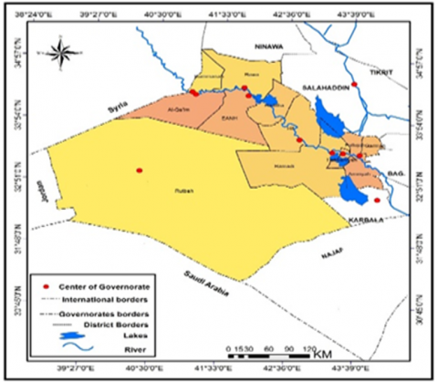
The governorate is administratively divided into twenty-two units, as shown in Figure 1, consisting of twelve districts, which vary significantly in size. The largest district is Rutba, which ranks first in terms of area, covering 93,445 km², representing 67.7% of the total area of the governorate. In contrast, the smallest district is Habbaniya, which spans only 714 km², constituting 0.5% of the governorate’s total area. Table 1 provides a detailed overview of the districts in Al-Anbar Governorate and their respective land areas.
The administrative strategy of the urban system has played a major role in dividing Al-Anbar Governorate administratively into twelve districts, as shown in Table 1, Figures 1-3. The districts vary in their area from one to another. Rutba District ranks first in terms of area, with an area of 93,445 km², representing 67.5% of Al-Anbar Governorate’s area. It is a border district with Syria, Jordan, and Saudi Arabia and is characterized by a strategic location that makes it a link between neighboring countries. It represents a large desert area with low population density and limited expansion due to its spatial extremity, dependence on well water, and lack of basic services.
Table 1. Districts of Al-Anbar Governorate, their areas, and percentage distribution – 2023
|
Ref. |
Administrative Unit |
Area |
Ratio (%) |
|
1 |
Rutba |
93445 |
67.5 |
|
2 |
Ramadi |
7829 |
5.6 |
|
3 |
Amiriya |
1967 |
1.4 |
|
4 |
Falluja |
1200 |
0.8 |
|
5 |
Hit |
8353 |
6.0 |
|
6 |
Haditha |
3644 |
2.6 |
|
7 |
Habaniyah |
714 |
0.5 |
|
8 |
Qaim |
6460 |
5 |
|
9 |
Rawa |
5676 |
4.1 |
|
10 |
Anah |
5597 |
4.0 |
|
11 |
Garmah |
1038 |
0.7 |
|
12 |
Rumana |
2480 |
1.8 |
|
13 |
Anbar Total Area |
138403 |
100 |
Source: Ministry of Planning, Central Bureau of Statistics, Directorate of Statistics of Anbar Governorate
(a)
(b)
Figure 1. The geographical location of the administrative units of Al-Anbar Governorate in Iraq
Source: Ministry of Water Resources, General Directorate of Surveying – Al-Anbar Administrative
As for the second rank, it is held by Ramadi District, with an area of 7,829 km², representing 5.6%. It serves as the center of the governorate and is one of the largest cities in terms of population. It is located near the Euphrates River and is considered an important and main urban center, which contributed to population growth and attraction. Ramadi District witnessed urban expansion, especially after 2003, as a result of population growth, the increase in their numbers, and the increase in planning and reconstruction.
Habbaniyah District represents the smallest area, with an area of 714 km² and a percentage of 0.5% of the governorate's area for the year 2023. The city’s area is considered a true body from which it derives its strength, and each administrative unit has its own land that affirms its existence through that area.
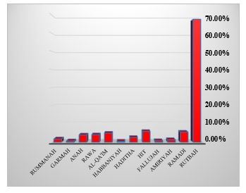
We note from Figures 2 and 3 that large cities have small areas but high population density, unlike districts that represent large areas with low population numbers. Rutba District represents the largest district in terms of area, and its size is small compared to other cities.
Figure 2. Distribution of Al-Anbar Governorate districts by area
Source: Based on Table 1
Figure 3. Area of Al-Anbar Governorate according to its administrative units – 2023
Source: Table 1
Iraq has relied on administrative decisions to grant urban status to settlements. Each district (Qadha) includes a central urban hub, which serves as the district's main urban complex, alongside the urban centers of its sub-districts [6].
It can be inferred that the urban nature of human settlements in Al-Anbar was influenced by the decline of Ottoman decrees. During the Ottoman era, administrative structuring was governed by administrative decisions issued through imperial decrees (Salnameh). This system divided Ottoman territories into administrative units, starting from the sub-district (Nahiyah), followed by the district (Qadha), the sanjak (Liwā’), and finally, the province (Wilāyah) [7].
During the tenure of Governor Midhat Pasha, Al-Anbar Governorate in its current geographical extent comprised two main districts:
(1) Ramadi District, which served as an administrative center, bearing the same name as the city established by the Ottoman governor to maintain security and stability.
(2) Anah District was established to manage the affairs of the Upper Euphrates region from Anah to Raqqa.
During this period (1875–1909), the name of Ramadi District was changed to Dulaim District, reflecting the demographic composition, as the majority of its inhabitants belonged to the Dulaim tribes [8]. The district was further subdivided into the district center and the sub-districts of Hit, Kubaysah, and Rahaliyah. Similarly, Anah District was subdivided into the district center and the sub-districts of Al-Qaim, Haditha, Jubbah, and Al-Wus [9].
With the fall of Ottoman rule, Al-Anbar Governorate became administratively divided into two districts, comprising six sub-districts and two district centers, resulting in seven urban centers that were affiliated with the Ottoman administrative jurisdiction of Baghdad. At that time, the city of Ramadi had not yet fully developed as an integrated urban center, as its population in 1910 did not exceed 7,500 residents [10].
The establishment of administrative units and urban centers was driven by the fact that most cities in Al-Anbar functioned as transportation hubs ("stage cities"), forming the nuclei around which human settlements grew. These centers expanded along ancient and modern international trade routes, ensuring security and stability along these routes while providing protection for trade caravans. One of the most significant routes was the Baghdad–Raqqa–Euphrates Route [11].
These factors contributed to the urban attraction of these centers, as they benefited from economic surpluses generated by their urban functions [12]. Population factors play a crucial role in influencing economic and social activities within a city [13].
3.2 Phases of administrative unit establishment in Al-Anbar
3.2.1 First phase (1920–1958)
The administrative factor remained a key and effective indicator in managing Iraq’s affairs following the establishment of the monarchy in 1921. The country was administratively divided into ten provinces (liwās), which increased to fourteen by 1924, including Al-Dulaim Province. By 1957, this province contained eight urban centers, which were:
Ramadi District, comprising (Ramadi center and Hit sub-district).
Fallujah District, established by Royal Decree No. 866 in 1925, comprising (Fallujah center and Al-Karmah sub-district).
Anah District, comprising (Anah center and the sub-districts of Haditha and Al-Qaim) [14].
Al-Karmah was previously called "Al-Dulaimiya," named after the Dulaim tribes. However, in 1932, it was renamed Al-Karmah after the river that linked the Euphrates and Tigris. It was granted administrative status by Royal Decree No. 1835 in 1936. Additionally, Rutbah sub-district was established in 1926 and was directly linked to the Ministry of Interior, responsible for border administration and organizing the affairs of nomadic Bedouins in the Western Desert [15].
3.2.2 Second phase (1959–2003)
Between 1958 and 1966, Iraq witnessed political changes that influenced its administrative structure. The name Al-Dulaim Province was changed back to its historical name, Al-Ramadi Province, aligning with the end of tribalism, feudalism, and the dominance of law and governance. This shift marked a new phase of urban development in the province, which by 1960 had eleven urban centers:
Ramadi District, including (Ramadi center, Habbaniyah, and Hit sub-districts).
Fallujah District, including (Fallujah center, Amiriyah, and Al-Karmah sub-districts).
Anah District, including (Anah center, Rawa, Al-Qaim, and Haditha sub-districts).
Rutbah District, including by 1966, two more urban centers (Barwana and Haqlaniyah) were added to Haditha District, increasing the total to thirteen urban centers. The renaming of the province led to several administrative changes, modernizing its administrative map:
(1) Establishment of Rawa sub-district in 1960, with its center in the flooded city of Rawa, administratively linked to Anah [16].
(2) Establishment of Habbaniyah and Amiriyah sub-districts. Initially, Habbaniyah’s urban center was at the Habbaniyah Air Base (civilian quarter), but in 1973, it was relocated to Khalidiya. Amiriyah sub-district remained under the jurisdiction of Fallujah District (Iraqi Gazette, Republican Decree No. 595, 1960). These sub-districts later became district centers.
Establishment of Al-Nukhayb sub-district after a series of government initiatives to secure borders and manage nomadic Bedouins in the Northern Desert. Initially, the government placed a police tent in Al-Nukhayb, later establishing its first police station in 1947, manned by local personnel [17]. In 1960, Republican Decree No. 596 officially recognized Al-Nukhayb as a sub-district under Rutbah District. The government sought to make Al-Nukhayb an administrative center and a catalyst for new urban settlements. In 1973, Al-Nukhayb was granted a fourth-class municipality status under Al-Anbar Governorate.
Establishment of Haditha District in 1965, separating it from Anah District. The district included Haditha center (now "Haditha Al-Sumoud"), Barwana, and Haqlaniyah sub-districts (Iraqi Gazette, Republican Decrees No. 139 and 155, 1965).
The administrative map of the main and secondary units of the district changed during the period 1967-1976 with the issuance of the Provincial Law No. 159, which led to the division of Iraq's administrative map into eighteen provinces [18].
Governorates were renamed based on historical references, and in 1970, Al-Anbar regained its historical name, replacing Al-Ramadi as the official designation [19]. This change commemorated the ancient city of Al-Anbar, which had disappeared, with its legacy inherited by locations such as Saqlawiyah and Fallujah, the latter considered its rightful successor [20]. This administrative evolution reshaped the territorial governance of Al-Anbar:
(1) Establishment of Administrative Units in Anbar Governorate
(2) Establishment of Hit District (1968)
Hit was upgraded from a subdistrict under Ramadi District in 1968, encompassing the Hit center, Kubaisa, and Al-Baghdadi subdistricts [20].
(3) Establishment of Al-Qa'im District (1968)
Al-Qa’im was separated from Ana District as a subdistrict and elevated to district status in 1968. That same year, Rumana and Karabila were established as subdistricts under Al-Qa’im [21].
(4) Establishment of Saqlawiyah Subdistrict
Saqlawiyah was designated as a subdistrict within Fallujah District [22].
Establishment of Kubaisa and Al-Baghdadi Subdistricts (1974).
Both were created as subdistricts under Hit District, with their administrative centers carrying the same names [23].
(5) Establishment of Al-Waleed Subdistrict (1976)
Al-Waleed was established at the Iraq-Jordan border crossing known as Al-Tanf and administratively linked to Rutba District [24].
During the period 1977-1997, administrative changes took place, particularly as the number of districts stabilized at seven in 1977, with the creation of the Al-Furat subdistrict, which was attached to the Hit district with its center in Zawiya Albu Nimr [25]. Accordingly, these districts included twenty-three district and subdistrict centers. However, the urban status of these centers was limited to only nineteen, as Al-Furat, Al-Rummanah, Al-Amiriyah, and Al-Nukhayb at that time did not have urban centers despite their administrative rank, due to the nature of their region, their activities, or their remote location. They were managed through villages and towns where subdistrict directors were present.
A significant change occurred in Nukhaib, where it was transferred from Anbar to Karbala in 1975 [26]. However, it was later returned to Rutba District in Anbar in 1979 [27].
In 1981, Law No. 40 was enacted to regulate the Nukhaib-Jadidah Arar-Saudi Arabia border crossing [28]. Nukhaib remained under Karbala from 1967 to 1978, then reverted to Anbar in 1979 [29]. An administrative downsizing initiative later resulted in the elimination of 107 subdistricts nationwide, including:
-Rumana and Karabila (Al-Qa’im District)
-Al-Baghdadi and Al-Furat (Hit District)
-Al-Rahaliya (Ramadi District)
-Al-Waleed (Rutba District)
These areas were reclassified as rural extensions of their respective districts The elimination of these subdistricts contributed to a decline in urbanization as urban centers decreased [30].
In 2001, Rawah was upgraded from a subdistrict to a district, with Rawah city as its center. Additionally, the (later dissolved) Al-Wafa Subdistrict was established within Ramadi District, with its center in Jubbah Village [31].
3.2.3 Third phase (2003–Present)
After 2003, the political system shifted, and the creation and upgrading of administrative units became influenced by political, party, and personal interests. As a result, the downsized subdistricts were reinstated.
At that time, Anbar consisted of eight districts with 17 urban centers. Subsequently, the following new administrative units were established:
(1) Amiriya Al-Sumoud District (2017)
-Separated from Fallujah District
-Center: Amiriya
-Assigned Statistical Code: 22091
-(Ministry of Planning, Administrative Decision No. 4/6/20078, 26/09/2017)
(2) Al-Muhammadi Subdistrict (2017)
-Under Hit District
-Assigned Statistical Code: 22025 [32]
-(Ministry of Planning, Administrative Decision No. 4/6/25611, 29/07/2017)
(3) Habbaniyah District (2018)
-Separated from Ramadi District
-Center: Khalidiya
-Assigned Statistical Code: 22101
(Ministry of Planning, Administrative Decision No. 4/6/1807, 21/08/2018)
(4) Karma District (2018)
-Separated from Fallujah District
-Center: Karma
-Assigned Statistical Code: 22111 [33]
(5) Rumana District (2019)
-Separated from Al-Qa’im District
-Center: Rumana (Al-Uboor)
-Assigned Statistical Code: 22121
-(Ministry of Planning, Administrative Decision No. 4/6/27807, 03/11/2019)
With these additions, Anbar Governorate now comprises 12 districts and 25 urban centers. This represents the current administrative framework of Anbar, as depicted in Figure 4.
Figure 4. Districts of Anbar Governorate by Establishment Phases (2023)
Source: Ministry of Water Resources, General Directorate of Survey, Administrative Map of Anbar, 2023
(1) The first phase of establishment took place from 1921 to 1958 and included the districts of Ramadi, Anah, and Fallujah.
(2) The second phase of establishment took place from 1959 to 2003 and included the districts of Rutbah, Haditha, Hit, Al-Qa'im, and Rawa.
(3) The third phase of establishment represents the contemporary period from 2004 to 2024 and includes the districts of Amiriyah, Habbaniyah, Karma, and Rummanah.
3.3 Population distribution of urban centers in Al-Anbar Governorate
The study of population distribution is of great importance due to its role in providing essential data about the population and its future impact on the density of population distribution, as well as on the direction of urban growth and expansion. Particularly, the concentration of population in urban centers leads to an increase in economic activities within the city, negatively affecting public services and depleting their capacities, in addition to encouraging rural-to-urban migration. Moreover, population distribution varies from one city to another (Table 2). Geographers agree that natural factors alone do not determine the pattern of population distribution. Pearson notes the prominence of these factors in terms of strength and influence in shaping the types and patterns of population [34].
Table 2. Population estimates of Anbar governorate by administrative units, environment, and gender for the year 2023
|
District |
Subdistrict |
Urban |
Rural |
Total |
||||||
|
|
|
Male |
Female |
Total |
Male |
Female |
Total |
Male |
Female |
Total |
|
Ramadi |
Center of Ramadi |
130728 |
123284 |
254012 |
123878 |
117679 |
241557 |
254606 |
240963 |
495569 |
|
Al-Wafa |
3091 |
2916 |
6007 |
2998 |
2847 |
5845 |
6089 |
5763 |
11852 |
|
|
Total |
133819 |
126200 |
260019 |
126876 |
120526 |
247402 |
260695 |
246726 |
507421 |
|
|
Hit |
Center of Hit |
38985 |
36764 |
75749 |
10844 |
10301 |
21145 |
49829 |
47065 |
96894 |
|
Al-Baghdadi |
4114 |
3879 |
7993 |
17189 |
16329 |
33518 |
21303 |
20208 |
41511 |
|
|
Kubaisa |
9925 |
9385 |
19310 |
943 |
896 |
1839 |
10868 |
10281 |
21149 |
|
|
Al-Furat |
1913 |
1805 |
3718 |
15779 |
14989 |
30768 |
17692 |
16794 |
34486 |
|
|
Total |
54937 |
51833 |
106770 |
44755 |
42515 |
87270 |
99692 |
94348 |
194040 |
|
|
Falluja |
Center of Fallujah |
146729 |
138375 |
285104 |
48368 |
45947 |
94315 |
195097 |
184322 |
379419 |
|
Saqlawiyah |
5596 |
5277 |
10873 |
25692 |
24407 |
50099 |
31288 |
29684 |
60972 |
|
|
Total |
152325 |
143652 |
295977 |
74060 |
70354 |
144414 |
226385 |
214006 |
440391 |
|
|
Annah |
Center of Anah |
12279 |
11579 |
23858 |
6166 |
5857 |
12023 |
18445 |
17436 |
35881 |
|
Total |
12279 |
11579 |
23858 |
6166 |
5857 |
12023 |
18445 |
17436 |
35881 |
|
|
Haditha |
Center of Haditha |
27194 |
25646 |
52840 |
3052 |
2900 |
5952 |
30246 |
28546 |
58792 |
|
Al-Haqlaniyah |
8260 |
7790 |
16050 |
8004 |
7603 |
15607 |
16264 |
15393 |
31657 |
|
|
Barwana |
9782 |
9224 |
19006 |
5474 |
5199 |
10673 |
15256 |
14423 |
29679 |
|
|
Total |
45236 |
42660 |
87896 |
16530 |
15702 |
32232 |
61766 |
58362 |
120128 |
|
|
Rutba |
Center of Rutba |
16618 |
15672 |
32290 |
5301 |
5036 |
10337 |
21919 |
20708 |
42627 |
|
Al-Waleed |
176 |
165 |
341 |
3297 |
3132 |
6429 |
3473 |
3297 |
6770 |
|
|
Al-Nukhayb |
1242 |
1172 |
2414 |
842 |
800 |
1642 |
2084 |
1972 |
4056 |
|
|
Total |
18036 |
17009 |
35045 |
9440 |
8968 |
18408 |
27476 |
25977 |
53453 |
|
|
Qaim |
Center of Al-Qa’im |
43312 |
40845 |
84157 |
20477 |
19452 |
39929 |
63789 |
60297 |
124086 |
|
Al-Ubaidi |
1311 |
1236 |
2547 |
16128 |
15321 |
31449 |
17439 |
16557 |
33996 |
|
|
Total |
44623 |
42081 |
86704 |
36605 |
34773 |
71378 |
81228 |
76854 |
158082 |
|
|
Rawa |
Center of Rawa |
10606 |
10003 |
20609 |
3393 |
3224 |
6617 |
13999 |
13227 |
27226 |
|
Total |
10606 |
10003 |
20609 |
3393 |
3224 |
6617 |
13999 |
13227 |
27226 |
|
|
Amiriyah |
Center of Amiriyah |
14064 |
13263 |
27327 |
47374 |
45004 |
92378 |
61438 |
58267 |
119705 |
|
Total |
14064 |
13263 |
27327 |
47374 |
45004 |
92378 |
61438 |
58267 |
119705 |
|
|
Habaniyah |
Center of Habbaniyah |
18884 |
17809 |
36693 |
62046 |
58941 |
120987 |
80930 |
76750 |
157680 |
|
Total |
18884 |
17809 |
36693 |
62046 |
58941 |
120987 |
80930 |
76750 |
157680 |
|
|
Garmah |
Center of Garmah |
6864 |
6473 |
13337 |
71990 |
68389 |
140379 |
78854 |
74862 |
153716 |
|
Total |
6864 |
6473 |
13337 |
71990 |
68389 |
140379 |
78854 |
74862 |
153716 |
|
|
Al- Oboor |
Center of Al-Oboor District |
6546 |
6174 |
12720 |
15944 |
15994 |
31938 |
22490 |
22168 |
44658 |
|
Total |
6546 |
6174 |
12720 |
15944 |
15994 |
31938 |
22490 |
22168 |
44658 |
|
|
Anbar |
Total |
518244 |
488736 |
1006980 |
516072 |
490248 |
1006320 |
1034316 |
978984 |
2013300 |
Source: Ministry of Planning; Central Bureau of Statistics, Directorate of Anbar Governorate Statistics – Population Estimates for the Year 2023
The table represents the population estimates of Al-Anbar Governorate according to districts and urban and rural sub-districts. From the data in Table 2, we observe that the cities with the highest population numbers are represented by Ramadi District (507,421) and Fallujah District (440,391), indicating the presence of an urban concentration rate, as they constitute (50%) of the total population of the governorate, which is approximately (2,013,300) people. The Urban Primacy Index can be calculated using the following formula.
$Primacy\text{ }\!\!~\!\!\text{ }Indeo=\frac{p1}{p2}=\frac{507421}{440391}\approx 1.15$ (1)
where,
$p1$ = Population of the Largest City
$p2$ = Population of the Second City
That is, the population of Ramadi exceeds that of Fallujah by 15%, and the result of the index is (1.15), which is close to (1). This indicates a relative balance between the two cities, meaning there is a high concentration rate and urban primacy in the districts of Ramadi and Fallujah. Through this, it becomes clear that there is a significant disparity in population distribution among the districts of the governorate. That is, in Ramadi and Fallujah Districts, the percentage of the urban population is higher than in other peripheral areas where the rural percentage is higher. It is observed that Fallujah District ranks first in terms of urban population distribution, with the highest percentage reaching 295,977. It is considered an important economic and commercial center and is experiencing rapid urban expansion. In second place is Ramadi District (260,019), which represents the administrative and urban center of the governorate. In third place comes Hit District, where the urban population is 106,770, representing a relatively balanced ratio between urban and rural populations. As for the other districts, they suffer from weak population growth and are predominantly rural in nature. They require planning policies to improve infrastructure and provide basic services such as education, health, and transportation. They also need encouragement and stimulation of economic activity to reduce migration.
(1) The study of the administrative strategy revealed a pivotal role in reshaping the urban system of Al-Anbar Governorate, as it helped in the creation of new administrative units (districts and sub-districts), contributing to the expansion and increase of urban centers from 8 districts to 12 districts between 2003–2023.
(2) Administrative decisions helped transform some villages and rural settlements into urban centers, which contributed to the diversification of economic activities and improvement of infrastructure and services in some urban centers.
(3) The study revealed a clear spatial disparity among the governorate's regions in terms of urbanization level and service distribution, as Ramadi and Fallujah Districts dominated the largest share of the urban population, accounting for 50% of the governorate’s population in 2023.
(4) The administrative strategy contributed to the formation of an unbalanced urban pattern, as some peripheral districts such as Rutba, Anah, Rawa, Rumana, and Karma continue to suffer from low population density and a lack of basic services.
(5) The absence of a clear, comprehensive, and integrated urban policy for population distribution reflects an unbalanced and inefficient urban growth and reveals a defect in the urban hierarchy.
4.1 Proposals
(1) Strengthen administrative plans in reshaping the spatial structure of the urban system in Al-Anbar Governorate through the creation of new administrative units that directly affect population and service distribution.
(2) Link administrative decisions with economic and demographic planning to prevent randomness in granting urban status and to ensure that each administrative unit plays a functional role serving the population of its area and neighboring regions.
(3) Work on developing rural areas and urban peripheries to enhance services, improve infrastructure, and stabilize the population-especially in Rutba District-to activate its role as an urban area.
(4) Adopt advanced statistical and spatial analysis methods to study the development of urban centers, identify spatial disparities, and direct administrative decisions toward addressing urban gaps instead of unbalanced and unplanned expansion.
Adopt an integrated urban vision when creating administrative units to achieve urban balance that ensures equitable distribution of services and diversification of economic activities across all urban centers of the governorate, especially in peripheral areas.
[1] College of Education. A master's thesis at the College of Education/University of Maysan discusses the urban system in Maysan Governorate. https://uomisan.edu.iq/eduweb/ar/archives/1666, accessed on Jun. 25, 2025.
[2] AlShameri, N. (2018). A Geographical vision for the development of the urban system in Taiz Governorate, Yemen. An-Najah University Journal for Research-B (Humanities), 33(4): 557-596. https://doi.org/10.35552/0247-033-004-002
[3] Salim, H.K. (2017). The development of the sizes and ranks of cities in the urban system in Najaf and Babil governorates for the period (1977-2015). Journal of Geographical Research, 1(25): 131-161. https://iasj.rdd.edu.iq/journals/uploads/2025/02/03/6d6f3bdd28f0538af3345eef63897b2a.pdf.
[4] Giesen, K.R., Ruhr, M.A.D. (2012). Zipf’s law for cities and the double pareto lognormal distribution. https://duepublico2.uni-due.de/servlets/MCRFileNodeServlet/duepublico_derivate_00031100/Giesen_Diss.pdf.https://duepublico2.uni-due.de.
[5] Ali, D.K., Al-Dulaimi, Y., Jumaa , M.A.R. (2023). The tourism development strategy in the Anbar governorate. Dirasat Human and Social Sciences, 50(6): 231-245. http://doi.org/10.35516/hum.v50i6.7055
[6] Al Ani, A., Al Kubaisi, A. (2020). Morphology of residential housing of Al Fallujah City. International Journal of Innovation, Creativity and Change, 14(10): 814-840.
[7] Ali, B.B., Globe, L.R., Salh, A.M. (2025). Analyzing directional urban sprawl from 1978 to 2023 using Shannon entropy analysis on Landsat imagery: A case study in Ramadi City, Iraq. International Journal of Geoinformatics, 21(3): 62-70. https://doi.org/10.52939/ijg.v21i3.3995
[8] Hassan, H.T., Thahir, A.F. (2023). Bahaa al-Din Nuri Baba Ali's entering to the political fray from January 1941 until January 1949. Journal of College of Education, 50(1): 210-220. https://doi.org/10.31185/eduj.Vol50.Iss1.3428
[9] Armstrong, M.C. (2020). The Mysteries of Haditha: A Memoir. Potomac Books.
[10] Abbas, A.A., Hussein, S.H. (2023). Unveiling Baghdad’s urban identity: A comprehensive study on the dynamics of urban imprint. Academia Open, 9(2): 10.21070/acopen.9.2024.8238. https://doi.org/10.21070/acopen.9.2024.8238
[11] Sayel, J.J., Khalaf, A.M., Al-Bayati, A.H.I. (2025). Spatial distribution of some soil characteristics of Ramadi district, western Iraq. International Journal of Environmental Impacts, 8(1): 103-111. https://doi.org/10.18280/ijei.080111
[12] Al-Kubaisi, A., Al-Anbaki, K. (2020). Urban attraction and its effects on constructional environment of Baqubah city. Dirasat: Humajln and Social Sciences, 47(2): 471-485. https://archives.ju.edu.jo/index.php/hum/article/view/107452.
[13] Periman, J.E. (1980). Myth of Marginality: Urban Poverty and Politics in Rio de Janeiro. University of California Press.
[14] Kraak, M.J., Ormeling, F. (2023). Cartography: Visualization of Geospatial Data, Fourth Edition 4th Edition. CRC Press.
[15] Al- Rawi, A.N.S.S., Al-Janabi, H.K. (2005). Role of the administrative factor in changing the sizes and levels of urban centers in Anbar Province during the period 1977-2005. Anbar University Journal for Humanities, 12.
[16] Republican Decree No. 525. (1960). Iraqi Gazette.
[17] Mutar, Y.Y.J., Abdullah, A.R.M. (2025). Urban planning of desert human settlements in Iraq. International Journal of Sustainable Development and Planning, 20(7): 3045-3055. https://doi.org/10.18280/ijsdp.200729
[18] Al-shameri, N. (2019). A Geographical Vision for the Development of the Urban System in Taiz Governorate, Yemen. https://journals.najah.edu/media/journals/full_texts/2_IfvRcyc.pdf.
[19] Revolutionary Command Council (dissolved) Decree No. 343 of 1970. Iraqi Official Gazette, 1970.
[20] Bretagnolle, A., Pumain, É.D.E.D. (2025). From theory to modelling: urban systems as complex systems. Cybergeo: European Journal of Geography, Dossiers, document 335. https://doi.org/10.4000/cybergeo.2420
[21] Iraq. Ministry of Justice. (1968). Republican Decree No. 267. Baghdad: Iraq. Ministry of Justice.
[22] Iraq. Ministry of Justice. (1974). Republican Decree No. 468. Baghdad: Iraq. Ministry of Justice.
[23] Iraq. Ministry of Justice. (1976). Republican Decree No. 2509. Baghdad: Iraq. Ministry of Justice.
[24] Iraq. Ministry of Justice. (1977). Republican Decree No. 288. Baghdad: Iraq. Ministry of Justice.
[25] Iraq. Ministry of Justice. (1976). Republican Decree No. 2509. Baghdad: Iraq. Ministry of Justice.
[26] Iraq. Ministry of Justice. (1979). Republican Decree No. 2726. Baghdad: Iraq. Ministry of Justice.
[27] Iraq. Ministry of Justice. (1981). Republican Decree No. 2860. Baghdad: Iraq. Ministry of Justice.
[28] Republican Decree No. 408 (Issuance of Banknotes). https://wiki.dorar-aliraq.net/iraqilaws/?p=9282.
[29] Pacione, M. (2005). Urban Geography: A Global Perspective (2nd ed.). Routledge.
[30] Hamad, M.B., Mikhlif, A.M. (2025). Demographic shift in the age structure of the population of Anbar Province (Ramadi District as a Model) (1997-2023). International Journal of Sustainable Development and Planning, 20(4): 1709-1719. https://doi.org/10.18280/ijsdp.200432
[31] Ministry of Planning, Administrative Decision No. 4/6/20078 on 26/9/2017. (2017). Iraqi Official Gazette.
[32] Ghadeeb, M. (2020). The planning problems and defects that accompanied the development of the basic plans for the city of Ramadi. Dirasat: Human and Social Sciences, 47(2).
[33] Perlman, J.E. (1976). The Myth of Marginality: Urban Poverty and Politics in Rio de Janeiro. University of California Press.
[34] Peters, G.L., Larkin, R.P. (1979). Population Geography, Problems, Concepts, and Prospects. Kendall/Hunt Publishing Company.