M. Ansyar Bora*![]() | Ririt Dwiputri Permatasari
| Ririt Dwiputri Permatasari![]() | Luki Hernando
| Luki Hernando![]() | Hisyam Ma’wa Abdullah
| Hisyam Ma’wa Abdullah![]() | Teddy Elvaro Siagian
| Teddy Elvaro Siagian![]() | Vinsensius Fendy Kurniawan
| Vinsensius Fendy Kurniawan![]() | Angga Kurniawan
| Angga Kurniawan![]() | Amanda Puspita Sari
| Amanda Puspita Sari![]() | Erica
| Erica![]() | Nur Shilah
| Nur Shilah![]() | Haidil Fauzan
| Haidil Fauzan![]()
© 2025 The authors. This article is published by IIETA and is licensed under the CC BY 4.0 license (http://creativecommons.org/licenses/by/4.0/).
OPEN ACCESS
Public cemetery management (PCM) in urban areas faces serious challenges such as limited land, inefficient administration, and low service transparency. This study aims to develop and evaluate a Smart Cemetery System (SCS) called SILAYA, which integrates Geographic Information System (GIS) technology with cognitive ergonomics principles to improve efficiency and user experience. The study design used a mixed approach: quantitative data were obtained through digital mapping using QGIS, usability evaluation using the System Usability Scale (SUS), and workload measurement using NASA-TLX; while qualitative data were obtained from interviews and focus group discussions with stakeholders. The results showed a significant improvement in usability, with the average SUS score increasing from 62.3 (pre-test) to 81.7 (post-test) among users, and from 57.5 to 89.5 among TPU managers. Cognitive load also decreased substantially, with the NASA-TLX score decreasing from 68 (high category) in the manual system to 33 (low category) after SILAYA implementation. These findings demonstrate that the integration of GIS and cognitive ergonomics effectively improves service efficiency, data accuracy, and user experience in PCM. Theoretically, this study enriches the literature on intelligent systems based on human-centered design, while practically offering a modern, inclusive, and sustainable cemetery management model for urban areas.
cognitive ergonomics, GIS, smart burial system, usability, workload, SILAYA
Public cemetery management (PCM) is an important element in city infrastructure that is often overlooked in urban spatial planning and management [1-4]. In fact, the existence of a good cemetery management system has a significant contribution to the quality of life of the community, especially in terms of ensuring public services, the sustainability of urban space, and respect for social and cultural values [5, 6]. Panas Public Cemetery (TPU) not only functions as a final resting place for the community, but also as part of the city landscape that reflects the management of public space and humanitarian values [7-9]. However, in various developing cities, including Batam, PCM still faces various fundamental challenges.
As one of the cities with the highest population growth rate in Indonesia, Batam is experiencing considerable pressure on land availability, including burial grounds [10]. The Batam City Central Statistics Agency recorded that Batam's population would reach approximately 1.257 million by 2024 and this figure is expected to continue to increase with the development of the industrial, trade, and service sectors [11, 12]. This rapid population growth directly increases the need for burial land, while land availability in island cities like Batam is increasingly limited (Figure 1). This increasingly acute land shortage raises serious issues in the management of PCM, which if not handled properly, can impact the regularity of spatial planning and the quality of public services [13].


In addition to the physical challenges of limited land, PCM management in Batam is also hampered by a manual and unintegrated administration and recording system. This creates a number of problems, ranging from difficulties in data collection, delays in services, and uncertainty for the public seeking information regarding grave availability. The manual process also poses the risk of data duplication, irregular grave arrangements, and limited transparency in management. For grieving families, this situation poses an additional burden, as slow access to information can hinder the smooth burial process.
In the era of digital transformation and smart city development, the delay in technology adoption in PCM management creates a significant gap between community needs and government services. Implementing a Smart Cemetery System (SCS) is a relevant solution to address this challenge. The information technology-based SCS enables data integration, digital record-keeping, and more transparent and efficient online public services [14]. One of the potential supporting technologies is the Geographic Information System (GIS), which is capable of managing spatial and non-spatial data in an integrated manner [15-17].
In this context, Quantum GIS (QGIS) as an open source mapping software [18] offers a significant opportunity to optimize PCM. With QGIS, cemetery data can be digitally mapped, dynamically updated, and easily accessed by both the public and administrators. The application of GIS to PCM has been shown to improve the accuracy of land mapping, facilitate grave location searches, and optimize the use of limited cemetery land [19]. Furthermore, GIS-based digital mapping can also strengthen the principles of transparency and accountability in public services. Through an integrated online system, the public can find out land availability, grave status, and location in real time, thereby reducing uncertainty and increasing service efficiency.
However, the success of SCS implementation is determined not only by the sophistication of the technology used, but also by the extent to which the system is designed with cognitive ergonomics in mind. In the context of cemetery management, system users come from two distinct groups: PCM officers as technical operators and the general public as end users. PCM officers may be familiar with administrative and technical aspects, but not all have sufficient digital literacy to operate complex systems. Meanwhile, the general public who must access information related to cemeteries or make plot reservations often come from diverse backgrounds, including those with limited technological knowledge. If the system is designed to be too complex or inappropriate for the cognitive capacity of users, the technology intended to improve efficiency will actually become a barrier to service delivery [20].
In this framework, the principles of cognitive ergonomics play an important role in bridging the gap between technology and users [21]. Cognitive ergonomics focuses on how systems can be designed to suit human mental capacity, workload, perception, and problem-solving abilities, with the aim of ensuring fast and responsive human-machine interaction [22]. The SCS interface must be simple, intuitive, and adaptive to ensure ease of use by anyone, including users with limited digital skills. This concerns not only visual clarity and navigation, but also how information is displayed, workflows are structured, and the extent to which the system reduces the cognitive load of its users. By implementing these principles, the system can prevent operational errors, speed up the information search process, and instill confidence in users in utilizing technology.
Furthermore, the application of cognitive ergonomics in the design of the SCS also has significant social implications. An inclusive and user-friendly system will encourage broader community participation, thereby increasing the legitimacy and sustainability of its implementation. In the context of public services, technological accessibility for all levels of society is a key factor in ensuring the equitable distribution of the benefits of digitalization. Therefore, this study positions cognitive ergonomics as an integral component in the development of the SCS, with the goal of not only creating modern technological solutions but also building a system that can be accepted, adopted, and optimally utilized by all stakeholders.
The urgency of this research lies in the fact that PCM in large cities like Batam faces multidimensional pressures, ranging from limited land, rapid population growth, to delays in the adoption of digital technology. Therefore, innovative technology-based solutions are needed that not only improve management efficiency but also consider humanitarian and sustainability aspects. This research seeks to develop a QGIS-based SCS by integrating cognitive ergonomics principles into the interface design, thereby creating a modern, inclusive, and sustainable PCM system. Thus, this research not only contributes to improving public services at the local level but can also serve as a model for the development of technology-based public services in other cities in Indonesia.
The novelty of this research lies in the integration of a GIS-based SCS with the application of cognitive ergonomics principles in user interface design. Although the use of GIS for cemetery mapping has begun to be introduced in several countries around the world, most previous research and implementations have focused solely on the technical aspects of mapping and the efficiency of land management [23]. These studies rarely consider how the developed systems can be truly accessed and used effectively by the general public with varying levels of digital literacy. Therefore, this study presents a new approach by emphasizing the importance of human-centered design, which focuses on the cognitive abilities of users, so that the system is not only technically functional but also inclusive and easy to use.
Furthermore, the novelty of this research lies in the context of managing public cemeteries in an island city with limited land like Batam. Most studies on urban land management focus on the housing, transportation, or economic infrastructure sectors, while cemeteries rarely receive attention despite their high social urgency. By integrating cemeteries with smart technology, this research makes a new contribution to the discourse on smart cities and technology-based public services, particularly in previously neglected sectors. This broadens the scope of smart system applications, which are typically focused on transportation, energy, and healthcare, to include socio-cultural sectors that play a crucial role in people's lives.
Furthermore, this study introduces a conceptual model that combines QGIS-based digital mapping with a cognitive ergonomics-based interface, a technique rarely found in previous literature. This integration is expected to produce a system that not only optimizes the use of limited cemetery land but also improves transparency, public service efficiency, and user experience.
To date, very little research has empirically tested the integration of GIS-based cemetery systems with cognitive ergonomics, particularly in the context of developing countries. Therefore, this study offers a theoretical contribution by enriching the literature on cognitive ergonomics and smart systems, as well as a practical contribution by developing concrete solutions that can be implemented in urban PCM. Based on the problems described, as well as the research gap related to the integration of GIS technology with cognitive ergonomics principles in PCM, this study proposes the development of a SCS through a mixed approach.
2.1 Integration of cognitive ergonomics with smart systems
Cognitive ergonomics emphasizes understanding human interactions with systems, including perception, memory, information processing, and decision making [24-26]. In a broader context, ergonomics can be defined as a scientific discipline that studies the relationship between humans, technology, and the work environment with the aim of optimizing human well-being and improving overall system performance [27-29]. In the context of digital systems, this principle is crucial for ensuring that interfaces are easy to understand and use, especially for users with varying cognitive abilities. Designs that ignore cognitive aspects can increase the risk of user errors and reduce system efficiency [30-32].
For the general public with varying levels of digital literacy, cognitive ergonomics is key to ensuring an inclusive and user-friendly system. This includes the use of easily recognizable icons, simple language, and a logical navigation flow. By implementing cognitive ergonomics, user interactions with the system can be faster, more effective, and minimize errors [33-35]. Meanwhile, the SCS is an implementation of the smart city concept for cemetery management, which integrates information technology, GIS, and online services to increase efficiency and transparency [36]. This system allows for digital recording of burial data, mapping of grave locations, and online reservation of burial plots, thereby improving services for the public [37-39]. Most research on smart systems focuses on technical aspects, such as infrastructure, data security, and information processing algorithms, while user experience is often neglected [40, 41]. In fact, user experience is a key factor in the successful adoption of digital systems. A sophisticated system that is difficult to use can actually reduce effectiveness and create resistance from users [42, 43].
2.2 Research gap
Research related to smart cities mostly focuses on transportation, energy, and administrative services while cemetery management rarely receives attention [44-46]. Meanwhile, studies discussing SCS tend to emphasize technical aspects, such as GIS mapping without highlighting user experience and interface design based on cognitive ergonomics [47-49].
This situation indicates a research gap, particularly regarding the integration of digital technology and cognitive ergonomics principles in cemetery management in developing cities with limited land. Research bridging this gap remains very limited, especially that providing empirical evidence regarding system effectiveness for end users.
The integration of cognitive ergonomics into SCS allows for a more intuitive system interface, reducing cognitive load, and simplifying interactions. These include easy-to-navigate digital maps, quick search menus, and consistently presented information [50]. This makes the system more inclusive for all users, including those who are not familiar with technology.
Furthermore, the application of cognitive ergonomics also increases digital inclusivity, expanding public access to public services. This demonstrates that systems that consider cognitive capacity can reach previously marginalized user groups, including the elderly and individuals with limited digital literacy [51, 52]. In the context of SCS, this ensures that all levels of society can access funeral information and services easily and conveniently.
Therefore, this research offers novelty by combining a GIS-based SCS with an interface design that considers cognitive ergonomics, resulting in a system that is not only technically efficient but also inclusive and easy to use. This research is expected to provide theoretical and practical contributions, while also providing a foundation for the development of more human-centered digital public services in the future.
3.1 Research design
This study employed a mixed-research design combining quantitative and qualitative approaches. The quantitative approach focused on the development and evaluation of a GIS-based SCS and digital management, while the qualitative approach emphasized cognitive ergonomics assessments to ensure the system was user-friendly for both TPU officers and the general public. This design enabled a comprehensive evaluation of the system's effectiveness, ease of use, and user satisfaction.
3.2 Research location
The research was conducted at the Sei Panas Public Cemetery (TPU) in Batam City, Riau Islands, Indonesia, a rapidly growing city facing land limitations due to high population growth.
3.3 Data collection
3.4 System development
The SCS prototype was developed through three main stages:
3.5 Instruments
The SUS instrument consists of 10 statements rated on a Likert scale of 1–5, covering aspects of ease of use, interface consistency, and overall user satisfaction (Table 1). The SUS test was conducted on 30 user respondents and 10 TPU management respondents at the pre-test stage (before the implementation of SILAYA) and post-test (after the implementation of SILAYA). The average SUS score was then analyzed to determine the level of user acceptance and satisfaction with the developed system. After the SUS test, a cognitive load analysis was carried out using the NASA-TLX (Task Load Index) instrument withThe six main indicators measured include Mental Demand (MD), Physical Demand (PD), Temporal Demand (TD), Performance (P), Effort (E), and Frustration Level (F).
Table 1. Question SUS
|
No. |
Question |
|
1 |
SILAYA is difficult to learn and use without special training. |
|
2 |
The SILAYA interface makes it easier for me to access the available menus. |
|
3 |
SILAYA does not help speed up the process of searching and managing document archives. |
|
4 |
This system makes document storage safer and more organized. |
|
5 |
Overall, I am not satisfied with using SILAYA for archiving activities. |
|
6 |
SILAYA helps me reduce dependence on physical documents. |
|
7 |
The SILAYA interface is confusing and not easy to understand for new users. |
|
8 |
SILAYA supports the smooth workflow of archiving in the institution/organization. |
|
9 |
This system does not provide adequate security assurance for digital archives. |
|
10 |
Using SILAYA provides significant benefits compared to manual methods. |
The System Usability Scale (SUS) instrument was chosen because it is a robust and widely used tool in digital system usability testing, with the ability to provide reliable benchmark values. Meanwhile, the NASA-TLX was used because it provides a comprehensive measurement of cognitive workload across six dimensions, making it highly suitable for assessing user interactions in complex decision-making systems.
Implementation the SCS through the SILAYA application has significantly improved efficiency, transparency, and user experience in the management of the Sei Panas Public Cemetery (TPU) in Batam. The analysis was conducted by comparing the manual system (AS-IS) and the proposed GIS-based and cognitive ergonomics-based system (AS-To-Do).
4.1 SILAYA application interface display
The SILAYA interface was developed based on cognitive ergonomics principles to ensure ease of use for both the general public and TPU administrators. The initial appearance of the application is shown in Figure 2, namely the SILAYA Login and Dashboard pages, the Login page is designed with high-contrast text, clear input fields, and large action buttons. This design improves visibility, reduces input errors, and speeds up user Login.
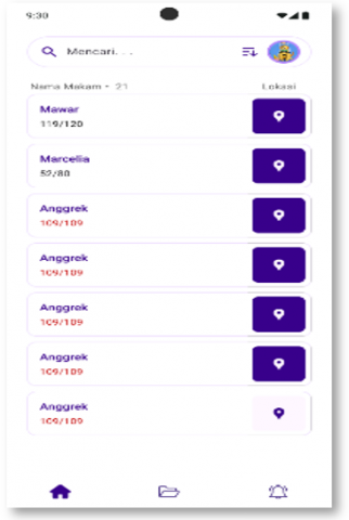
After successfully logging in, users are directed to the SILAYA Dashboard, which displays four main features: Grave Search, Location Map, Booking, and Application Status. Each feature is displayed with large icons and easily distinguishable visual cards, supporting recognition over recall and reducing cognitive load. Consistent bottom navigation also helps speed up transitions between menus.
Figure 2. SILAYA Login and Dashboard
4.2 System development
To clarify the integration of SILAYA, Figure 3 presents a system architecture consisting of three main layers: the GIS Layer, the Application Layer, and the Database Layer. The GIS layer handles QGIS-based spatial mapping and generates geospatial data in GeoJSON format. The application layer handles system logic, including reservation management, grave search, authentication, and map display control. The database layer stores all information related to graves, users, and transactions. Data flows from QGIS to the application through spatial synchronization, then is presented to users through both the admin interface and the general public.
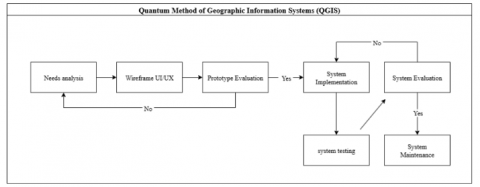
4.3 Information system design methods
The system design process began with a needs analysis, which emphasized identifying cemetery management constraints and community information needs. The next stage was system design and integration, which involved QGIS-based digital mapping and the application of cognitive ergonomics principles to the user interface. These stages are visualized in Figure 4, which shows the complete flow from requirements analysis to system implementation.

Figure 3. System architecture diagram
Figure 4. System design methods
Figure 4 shows the system design methodology used in this study. It began with a user needs analysis, which involved identifying the constraints faced by cemetery managers and the community in the cemetery management process. Next, system design and integration were conducted, including mapping cemetery land using Quantum GIS (QGIS) and applying cognitive ergonomics principles to ensure an intuitive user interface. The system was then tested at the Sei Panas Cemetery to obtain user feedback and evaluate its effectiveness in the context of more efficient cemetery management.
4.4 System testing methods
Testing was conducted to assess the efficiency and ease of use of the SCS. Aspects tested included response time, navigation, and online transaction processing speed. The testing process is shown in Figure 5.
Figure 5. System testing
System testing was conducted to assess the efficiency and ease of use of the SCS. Figure 5 illustrates the testing process, which measured response time, navigation efficiency, and the processing speed of online burial reservation transactions. The testing involved two groups: Cemetery management staff and members of the public using the system to search for burials or reserve burial plots.
4.5 System analysis
This section discusses a comparison between the existing cemetery management system (AS-IS) and the proposed system (AS-To Do), and how the new system can improve various aspects of cemetery management.
4.5.1 AS–IS
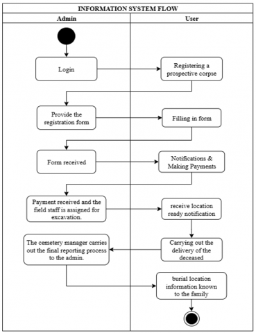
The existing situation (AS-IS) shows that the manual system still presents serious challenges, such as data duplication, delays in recording, and difficulties in locating graves. Figure 6 illustrates the AS-IS flow, which relies heavily on manual input.
Figure 6. AS-IS
The existing system (AS-IS) confirms that the manual system creates several obstacles, such as data duplication, delays in registration, and difficulties in locating graves (Figure 6). This process relies entirely on manual input, resulting in inefficiency and minimal transparency. In contrast, the proposed system (AS-To Do), visualized in Figure 7, integrates online registration, QGIS digital mapping, and online grave reservations. The activity diagram (Figure 8), context diagram (Figure 9), and data flow diagram (Figure 10) demonstrate a more structured, transparent, and real-time workflow. This integration aligns with previous research findings that digitizing public services can improve data accuracy and service accountability.
4.5.2 AS-To Do
The proposed system (AS-To Do) integrates digital mapping, online record-keeping, and burial plot reservation. Figure 7 visualizes the design of this system.
Figure 7. AS-To Do
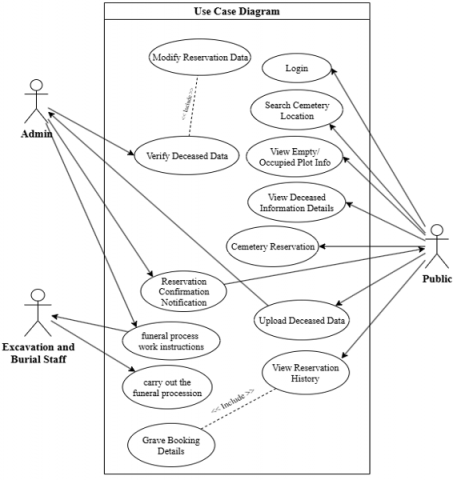
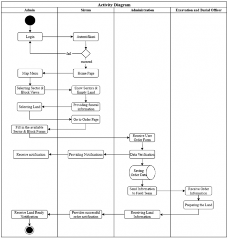
4.5.3 Activity diagram
Figure 8 displays an activity diagram showing the SILAYA system workflow, from grave search to land reservation and data management.
Figure 8. Activity diagram
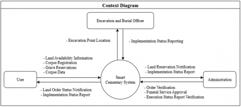
4.5.4 Context diagram
Figure 9 shows the relationship between the system and external entities (officers and the public).
Figure 9. Context diagram
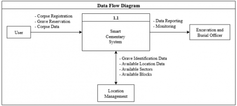
4.5.5 Data flow diagram
Figure 10 depicts the data flow, from user input to processing of ordering information and mapping of graves.
Figure 10. Data flow diagram
4.6 System design results based on cognitive ergonomics
To ensure usability aspects, the interface design was tested using cognitive ergonomics principles. A summary of the UI elements is presented in Figure 11.

Figure 11. UI/Cognitive ergonomics mapping
4.7 System design results based on test scenario with Black Box system method
Application testing is conducted using the Black Box method, which examines system functionality from the user's perspective without reviewing the program code. Test scenarios are summarized in Table 2.
Table 2. Application testing scenario tables
|
Test Class |
Test Details |
Method |
|
|
Registration as Admin and Public User |
Testing is performed by registering a new account in the SILAYA application using a full name, email address, and valid password. |
Black Box |
|
|
Login as Admin and Public User |
Testing is performed by entering a registered email and password. |
Black Box |
|
|
Add Cemetery Block |
Testing is performed by adding a new cemetery block through the "Sector" menu. |
Black Box |
|
|
Order Confirmation |
Testing is performed when the Admin receives a cemetery booking request from the public. The Admin verifies the deceased's data and selects the "confirm" option. |
Black Box |
|
|
Edit Deceased Data |
Testing is performed by editing stored deceased data (eg, name, date of death, or other details). |
Black Box |
|
|
Add News |
Testing is performed by adding new news articles through the "News" menu. |
Black Box |
|
|
Edit News |
Testing is performed by modifying existing news. Admin can edit the title, content, or image. |
Black Box |
|
|
Delete News |
Testing is performed by selecting existing news and clicking the "delete news" button. |
Black Box |
|
|
SILAYA Application Menus for Admin |
Sub Menu |
Description |
Black Box |
|
Buttons: Add, Edit, Delete, View, Save |
||
|
SILAYA Application Menus for Public Users |
Sub Menu |
Description |
Black Box |
|
Buttons: Add, Edit, View, Save |
||
|
Edit Profile |
Testing is performed by modifying the profile data of Admin or Public User (name, email, phone number, password, or address) and saving the changes. |
Black Box |
|
|
Log Out |
Testing this button is performed to ensure it functions properly. |
Black Box |
|
|
System Evaluation for SILAYA Application Users |
This test is conducted to determine whether the system meets user requirements. |
SUS |
|
4.8 System test results using the Black Box system method
Detailed results of the system testing are shown in Table 3, which includes the inputs and outputs of each major function.
Table 3. Systems table testing by using Black Box method
|
No. |
Test |
Input Description |
Expected Output |
Actual Output |
UI Location |
|
1 |
Registration |
Name: Angga Email: angga@gmail.com Password: 12345 Password: 12345 Action: Press the Register button
|
|
Registration Successful Page; successfully displayed (PASS) |
|
|
2 |
Login with valid credentials |
Email: Angga Password: 12345 Action: Press the Login button |
|
The system successfully displays the Dashboard page (PASS) |
|
|
3 |
Admin - Add Sector Button |
- Action: Admin presses the Add button - Sector Name: “Sector C”- Sector “capacity” Action: Admin presses the Confirm button |
-The system saves the new sector to the database. -The system displays the message: “Sector added successfully”. -The sector data appears in the sector list. |
The system successfully added sector data and the message displayed accordingly. (PASS) |
|
|
4 |
Admin - Add News Button |
Action: Admin presses the ADD button - News Name: “News” Action: Admin presses the Confirm button |
-The system saves new news to the database. -The system displays the message: “News added”. -News data appears in the news list. |
The system successfully added News and the message appears accordingly. (PASS) |
|
|
5 |
Admin - Add Deceased Button |
Action: Admin presses the ADD button - Data Input "Guardian" Action: Admin presses the Confirm button |
-The system saves the guardian's data to the database. -The system displays: "Guardian Data". -Guardian data appears in the list of guardians. |
The system successfully added the Guardian Data and the message appeared accordingly. (PASS) |
|
|
6 |
Admin - Order Confirmation Button |
Admin opens the Order menu |
-The system displays all incoming orders. Each order is displayed in a card containing: the name of the person ordering, type of service/plot, date, and status. |
The system displays a complete list of orders according to the data (PASS) |
|
|
7 |
Admin - Deceased Data |
Admin opens the Deceased Data menu |
-The system displays a list of stored bodies, each containing: name of the body, date of death/burial, sector/plot, and status. |
The complete list of bodies is displayed according to the existing data (PASS) |
|
|
8 |
Public - Add Deceased Button |
User opens Public – Deceased page |
-The Add Deceased button appears in the bottom right area (FAB) or header section. |
The Add Deceased button appears as designed (PASS) |
|
|
9 |
Public - Edit Profile |
Public users open the Edit Profile menu |
- The system displays a form containing the following fields: Full Name, Email, Telephone Number, Address, and an Update Profile button. The user's old data is automatically filled in. |
The Edit Profile form appears complete and all user data is automatically filled in (PASS) |
|
|
10 |
Log Out |
The user presses the Logout button on the profile menu/nav bar |
-The system deletes the user session- The system redirects the user to the Login page. -There is no access to pages that require authentication. |
The system deletes the session and redirects to the Login page without error (PASS)
|
|
4.9 Test results with the SUS
The usability aspect of the system was tested using the SUS on 30 community respondents and 10 TPU managers. The test results showed a significant increase in the average SUS score, increasing from 62.3 in the pre-test to 81.7 in the post-test for the user group (Figure 12), and from 57.5 to 89.5 for the manager group (Figure 13). The results of the SUS test showed a striking difference between conditions before and after the implementation of SILAYA in two groups of respondents, namely users and TPU managers (Figure 14). This increase of more than 30% confirms that the cognitive ergonomics-based interface design successfully produced a system that is intuitive, simple, and easy to use. According to SUS interpretation standards, a score above 80 is included in the excellent usability category. So SILAYA can be said to have a high level of acceptance among both users and administrators. This aligns with previous research confirming that user-oriented interface design systems will increase satisfaction, interaction consistency, and acceptance of digital systems.
To ensure the quality of the instrument, an internal validity analysis was conducted on the SUS questionnaire. From 30 community respondents, the analysis results showed that the corrected item–total correlation values for all 10 items ranged from 0.175 to 0.639, which meets the general feasibility limit of 0.17–0.30 in standard psychometric instruments. Furthermore, a Cronbach's Alpha value of 0.87 indicates an excellent level of internal consistency. Therefore, the SUS instrument used in this study can be declared valid and reliable for assessing perceived ease of use of the SILAYA system.

Figure 12. SUS user pre-test and post-test questionnaire results

Figure 13. SUS pre-test and post-test questionnaire results for cemetery managers

Figure 14. Comparison of SUS score users vs managers
4.10 Results of cognitive load measurement with NASA-TLX
Cognitive workload testing was conducted using NASA-TLX on the same group of respondents, namely 30 community members and 10 TPU managers. This instrument was used to assess changes in mental and physical difficulty levels during SILAYA use through pre-test and post-test stages. The six main dimensions measured included Mental Demand (MD), Physical Demand (PD), Temporal Demand (TD), Performance (P), Effort (E), and Frustration (F), as summarized in Table 4. The measurement results showed a significant decrease in all indicators after SILAYA implementation, which illustrates a reduction in mental burden and increased efficiency of system use.
Table 4. Comparison of average scores of NASA-TLX indicators
|
Indicator |
Pre-Test (Manual) |
Post-Test (SILAYA) |
Change |
|
Mental Demand (MD) |
68.23 |
35.00 |
Low |
|
Physical Demand (PD) |
68.14 |
30.00 |
Low |
|
Temporal Demand (TD) |
58.82 |
32.00 |
Low |
|
Performance (P) |
72.64 |
38.00 |
Low |
|
Effort (E) |
74.70 |
34.00 |
Low |
|
Frustration (F) |
50.29 |
28.00 |
Low |
|
WWL Average |
68 (High) |
33 (Low) |
Significant |
The internal validity of the NASA-TLX also demonstrated strong consistency. All six NASA-TLX dimensions had an item-total correlation of 0.740, indicating a strong contribution from each dimension to the total workload score. A Cronbach's Alpha of 0.658 also demonstrated adequate reliability, especially considering the small sample size typically used in operator workload studies. These results confirm that the NASA-TLX instrument in this study is valid and reliable for assessing cognitive workload in the context of using a digital cemetery management system.
These changes are further visualized in Figure 15.

Figure 15. Comparison of NASA-TLX pre-test vs post-test (SILAYA)
The NASA-TLX results showed a significant decrease in all indicators. The average Workload Weight Level (WWL) decreased from 68 (high category) in the manual system to 33 (low category) after the use of SILAYA (Table 4, Figure 12). The largest decreases occurred in the Effort (74.7 to 34.0) and Performance (72.6 to 38.0) aspects, indicating that the system successfully reduced cognitive load by more than 50%. These results confirm that the application of human-centered design principles is effective in improving user interaction, in line with cognitive ergonomics theory.
In addition to improving technical efficiency, SILAYA also plays a strategic role within the framework of smart city development. This system functions as a long-term spatial planning instrument through GIS-based digital mapping, while simultaneously increasing the transparency of public services. However, successful implementation is still influenced by the readiness of digital infrastructure and public technological literacy. Support from local government policies and integration with the population administration system are crucial factors for the system's sustainability and replication in other cities. This aligns with previous research that emphasizes the importance of synergy between technology, governance, and social readiness in the adoption of digital-based public services.
4.11 System implications for governance, transparency, policy integration and system limitations
The implementation of SILAYA not only improves technical aspects such as efficiency, ease of use, and reduced cognitive load, but also has a strategic impact on cemetery governance at the local government level. By digitizing GIS-based cemetery recording and mapping, this system strengthens the principles of good governance, particularly in terms of transparency, accountability, and the integration of public service policies.
First, service transparency is significantly improved through the real-time presentation of burial plot information. The public can access land status, burial locations, and reservation history without having to go through lengthy administrative processes. This reduces the potential for errors, data manipulation, and information conflicts that often occur in manual systems.
Second, SILAYA strengthens the accountability of TPU managers because all transactions, data updates, and verification processes are automatically recorded in the system. An audit trail mechanism allows for objective monitoring of officer performance and minimizes the risk of abuse of authority. These findings align with smart governance literature, which emphasizes the role of digitalization in improving the reliability of public administration.
Third, from a policy perspective, GIS-based SCS has great potential as a long-term spatial planning tool, especially for cities facing land constraints like Batam. Integrated spatial data helps the government:
This makes SILAYA not only a daily operational tool, but also a strategic foothold to support the integration of smart city policies and data-based public asset management.
Fourth, SILAYA also strengthens the public participation dimension, allowing the public to interact directly with data and services without technical barriers. This increased accessibility encourages broader use of digital services, including by vulnerable groups and the elderly, thereby increasing the inclusiveness of funeral services.
While SILAYA offers significant improvements in service efficiency and ease of use, the system still has several limitations. First, the quality of the spatial data used is highly dependent on the accuracy of the initial mapping, so in areas with incomplete data, the digitization process can take longer. Second, the performance of the GIS-based map viewer can be affected by network limitations in the cemetery area, especially in locations with unstable internet access. Third, variations in the community's digital literacy levels can affect the speed of initial adoption, so guidance or brief training is still needed.
In terms of scalability, SILAYA has high potential for implementation in other cities because the system architecture is modular and easily configured to suit each region's administrative regulations and cemetery structures. The cognitive ergonomics approach used is universal, allowing for seamless implementation. As long as data and infrastructure support are available, the system can be replicated as part of Smart City initiatives across multiple regions.
This study shows that the integration of GIS technology and cognitive ergonomics principles in the development of a SCS through the SILAYA application significantly improves the quality of public cemetery management. This system is proven to be able to overcome various weaknesses in manual administration, as reflected in the results of the usability and mental workload evaluation. The SUS score increased from 62.3 to 81.7 in the user group and from 57.5 to 89.5 in the TPU managers, thus entering the excellent usability category with a high level of acceptance. In parallel, the NASA-TLX score decreased from 68 to 33, which represents a reduction of more than 50% in respondents' cognitive load. These results confirm that the application of human-centered design principles not only improves system usability but also reduces mental stress and improves user performance.
Theoretically, this study enriches the literature on the integration of cognitive ergonomics with digital-based public service systems, an area that is still rarely researched. Practically, SILAYA presents an adaptive, inclusive, and sustainable public cemetery management model for cities facing land constraints. Future research is recommended to expand validation with a larger and more diverse sample size, and integrate new technologies such as the Internet of Things (IoT), predictive analytics, and artificial intelligence to strengthen the role of SCS in smart city ecosystems.
The author would like to express his gratitude to the Ministry of Higher Education, Science, and Technology of the Republic of Indonesia for the research grant funding support provided through the 2025 fiscal year program based on master contract No.138/C3/DT.05.00/PL/2025 and derivative contract No. 019/LL17DT.05.00/PM/2025 without whom the completion of this article would not have been possible. Special thanks are also extended to the Institute for Research and Community Service, Batam Institute of Technology, for their guidance, administrative assistance, and ongoing institutional support throughout the research process.
[1] Grabalov, P. (2024). Invisible public spaces: The role of cemeteries in urban planning and development in Moscow. Journal of Urban Affairs, 46(10): 1971-1991. https://doi.org/10.1080/07352166.2022.2147434
[2] Stumpe, B., Stuhrmann, N., Jostmeier, A., Marschner, B. (2024). Urban cemeteries: The forgotten but powerful cooling islands. Science of the Total Environment, 934: 173167. https://doi.org/10.1016/j.scitotenv.2024.173167
[3] Sallay, Á., Tar, I.G., Mikházi, Z., Takács, K., Furlan, C., Krippner, U. (2023). The role of urban cemeteries in ecosystem services and habitat protection. Plants, 12(6): 1269. https://doi.org/10.3390/plants12061269
[4] Greinert, A., Kostecki, J. (2025). Historical and contemporary cemeteries in the urban area. The modern development of the city vs. human remnants in the soil. Journal of Soils and Sediments, 25: 396-413. https://doi.org/10.1007/s11368-024-03870-2
[5] Maddrell, A., Beebeejaun, Y., Kmec, S., Wingren, C. (2023). Cemeteries and crematoria, forgotten public space in multicultural Europe. An agenda for inclusion and citizenship. Area, 55(1): 125-133. https://doi.org/10.1111/area.12824
[6] Grabalov, P., Nordh, H. (2022). The future of urban cemeteries as public spaces: Insights from Oslo and Copenhagen. Planning Theory and Practice, 23(1): 81-98. https://doi.org/10.1080/14649357.2021.1993973
[7] McClymont, K., Sinnett, D. (2021). Planning cemeteries: Their potential contribution to green infrastructure and ecosystem services. Frontiers in Sustainable Cities, 3: 789925. https://doi.org/10.3389/frsc.2021.789925
[8] House, D., Beebeejaun, Y., Maddrell, A., McClymont, K. (2024). Temporalities of cemeteries: The tensions and flows of perpetuity and change in ‘slow’ places. Mortality, 29(3): 431-446. https://doi.org/10.1080/13576275.2023.2170218
[9] Długozima, A. (2022). How to find a suitable location for a cemetery? Application of multi-criteria evaluation for identifying potential sites for cemeteries in Białystok, Poland. Moravian Geographical Reports, 30(1): 34-53. https://doi.org/10.2478/mgr-2022-0003
[10] Suwarlan, S.A., Lai, L.Y., Said, I. (2023). Social norms framework of suku laut in traditional coastal settlement of mainland Batam. International Journal of Sustainable Development and Planning, 18(3): 703-713. https://doi.org/10.18280/ijsdp.180306
[11] Fadhlurrahman, I. (2024). 57% Penduduk Kep. Riau ada di Kota Batam pada Pertengahan 2024. Databoks. https://databoks.katadata.co.id/demografi/statistik/eb5ed9eb58c51d7/57-penduduk-kep-riau-ada-di-kota-batam-pada-pertengahan-2024#:~:text=Kota.
[12] Badan Pusat Statistik Kota Batam. (2024). Kepadatan Penduduk Kota Batam (jiwa/km²), 2024. BPS Kota Batam. https://batamkota.bps.go.id/id/statistics-table/2/MTY5IzI=/kepadatan-penduduk.html.
[13] Petio, M.K. (2023). Reflections on urbanisation, land supply and the Ghanaian physical planning system towards sustaining cemetery land use in Greater Kumasi Metropolitan Area. Land Use Policy, 125: 106476. https://doi.org/10.1016/j.landusepol.2022.106476
[14] Zhang, S.F. (2019). Classification of urban land use based on graph theory and geographic information system. Ingénierie des Systèmes d'Information, 24(6): 633-639. https://doi.org/10.18280/isi.240611
[15] Muslih, M., Arianti, N.D., Somantri, Thamren, D.S., Fajri, Bulan, R. (2022). Utilization of a web-based geographic information system for land mapping and some its overview: A case study in Sukabumi district, Indonesia. International Journal of Design and Nature and Ecodynamics, 17(3): 369-374. https://doi.org/10.18280/ijdne.170306
[16] Tadya, C., Mulaudzi, R., Machate, F. (2023). Landfill site suitability analysis using geographic information system and remote sensing for Thohoyandou Town, South Africa. International Journal of Environmental Impacts, 6(3): 121-128. https://doi.org/10.18280/ijei.060304
[17] Muneer, A.S., Sayl, K.N., Kamel, A.H. (2020). Modeling of runoff in the arid regions using remote sensing and geographic information system (GIS). International Journal of Design and Nature and Ecodynamics, 15(5): 691-700. https://doi.org/10.18280/ijdne.150511
[18] Mutani, G., Beltramino, S. (2022). Geospatial assessment and modeling of outdoor thermal comfort at urban scale. International Journal of Heat and Technology, 40(4): 871-878. https://doi.org/10.18280/ijht.400402
[19] Mohd Noor, N., Khir Sabir, N.S., Ibrahim, I., Azhari, A.W., Mat Rejab, M.N. (2023). Geospatial technologies approach for cemetery management solutions: A review. Jurnal Planologi, 20(2): 105-118. https://doi.org/10.30659/jpsa.v20i2.30226
[20] Dörner, A., Bures, M., Simon, M., Pirkl, G. (2024). Making cognitive ergonomics in the human–Computer interaction of manufacturing execution systems assessable: Experimental and validation approaches to closing research gaps. Machines, 12(3): 195. https://doi.org/10.3390/machines12030195
[21] Hilmi, A.H., Abdul Hamid, A.R., Wan Ibrahim, W.A.R.A. (2024). Advancements in cognitive ergonomics: Integration with human-robot collaboration, workload management, and industrial applications. Malaysian Journal of Ergonomics (MJEr), 6(1): 39-51. https://doi.org/10.58915/mjer.v6.2024.1368
[22] Yadav, N.S., Aluvalu, R.K., Viswanadhula, U.M., Prashanth, M.S., Murthy, P.K.N.S. (2025). Cognitive computing in manufacturing: Transformative applications of natural language processing for human-machine interaction in Industry 4.0. International Journal of Computational Methods and Experimental Measurements, 13(1): 73-83. https://doi.org/10.18280/ijcmem.130108
[23] Amoah, E.G., Forkuor, D., Opoku, F. (2025). The last cityscapes: Public cemetery management in Kumasi’s urban terrain. Mortality, 30(3): 798-817. https://doi.org/10.1080/13576275.2024.2390468
[24] Aguiñaga, A.R., Realyvásquez-Vargas, A., López, M.Á., Quezada, A. (2020). Cognitive ergonomics evaluation assisted by an intelligent emotion recognition technique. Applied Sciences, 10(5): 1736. https://doi.org/10.3390/app10051736
[25] Gerlich, M. (2025). AI tools in society: Impacts on cognitive offloading and the future of critical thinking. Societies, 15(1): 6. https://doi.org/10.3390/soc15010006
[26] Bora, M.A., Lawi, A., Wijaya, I.M.S., Salsabilla, T.A. (2024). Mengoptimalkan kenyamanan kognitif: Analisis ergonomis terhadap interaksi pengguna dengan AI chatbots. Ranah Research: Journal of Multidisciplinary Research and Development, 6(4): 710-723. https://doi.org/10.38035/rrj.v6i4.869
[27] Bora, M.A., Hardi, Y., Dermawan, A.A., Cundara, N., et al. (2025). Application of REBA and QEC methods in redesigning clamping workstations to enhance ergonomic performance. Journal Européen des Systèmes Automatisés, 58(6): 1275-1284. https://doi.org/10.18280/jesa.580617
[28] Hanafie, A., Haslindah, A., Ansyar Bora, M., Yusuf, R., Larisang, Sanusi, Hamid, A. (2025). Study of flexibility factors in determining the design of ergonomic urban pedestrian sidewalk facilities. International Journal of Computational Methods and Experimental Measurements, 13(1): 35-43. https://doi.org/10.18280/ijcmem.130104
[29] Hutabarat, J., Pradana, J.A., Ruwana, I., Basuki, D.W.L., Sari, S.A., Septiari, R. (2023). Ergonomic chair design as a solution to musculoskeletal disorders among traditional cobblers: An anthropometric study. Journal Européen des Systèmes Automatisés, 56(4): 697-701. https://doi.org/10.18280/jesa.560419
[30] Gualtieri, L., Fraboni, F., Brendel, H., Pietrantoni, L., Vidoni, R., Dallasega, P. (2024). Updating design guidelines for cognitive ergonomics in human-centred collaborative robotics applications: An expert survey. Applied Ergonomics, 117: 104246. https://doi.org/10.1016/j.apergo.2024.104246
[31] Gumar, A.I. (2024). The effect of semantic shifts on cognitive ability between the user and industrial products. International Journal of Design and Nature and Ecodynamics, 19(1): 321-328. https://doi.org/10.18280/ijdne.190135
[32] Zhu, P.Y., Sun, L.L., Song, Y.F., Wang, L., Yuan, X.F., Dai, Z. (2020). Analysis on cognitive behaviors and prevention of human errors of coalmine hoist drivers. International Journal of Safety and Security Engineering, 10(5): 663-670. https://doi.org/10.18280/ijsse.100511
[33] Hasanain, B. (2024). The role of ergonomic and human factors in sustainable manufacturing: A review. Machines, 12(3): 159. https://doi.org/10.3390/machines12030159
[34] Ioniță, A.R., Anghel, D.C., Boudouh, T. (2025). Mind, machine, and meaning: Cognitive ergonomics and adaptive interfaces in the age of Industry 5.0. Applied Sciences, 15(14): 7703. https://doi.org/10.3390/app15147703
[35] Shi, J., Yusoff, I.S.M., bin Yahaya, M.F. (2024). Examining the relationship between innovative product design, cognitive ergonomics, and the effectiveness of entity design-system: Focusing on the environment of big data-driven interface. Journal of Information Systems Engineering and Management, 9(3): 29049. https://doi.org/10.55267/iadt.07.14869
[36] Alakbarova, I., Gurbanova, A. (2025). Digital cemetery: Challenges and prospects. Problems of Information Society, 16(2): 25-38. https://doi.org/10.25045/jpis.v16.i2.04
[37] Fialová, J., Bamwesigye, D., Łukaszkiewicz, J., Fortuna-Antoszkiewicz, B. (2021). Smart cities landscape and urban planning for sustainability in Brno city. Land, 10(8): 870. https://doi.org/10.3390/land10080870
[38] Wei, Y., Yuan, H., Li, H.C. (2024). Exploring the contribution of advanced systems in smart city development for the regeneration of urban industrial heritage. Buildings, 14(3): 583. https://doi.org/10.3390/buildings14030583
[39] Indrajit, A., van Loenen, B., Suprajaka, Jaya, V.E., Ploeger, H., Lemmen, C., van Oosterom, P. (2021). Implementation of the spatial plan information package for improving ease of doing business in Indonesian cities. Land Use Policy, 105: 105338. https://doi.org/10.1016/j.landusepol.2021.105338
[40] Permatasari, R.D., Bora, M.A., Hernando, L., Saputra, T., Fauzan, H., Shilah, N., Salsabila, T.A. (2025). Evaluating usability and clustering of SILCARE system for MSME shipping: A data-driven approach using SUS and user behavior analysis. Journal of Applied Data Sciences, 6(2): 997-1011. https://doi.org/10.47738/jads.v6i2.590
[41] Hernando, L., Permatasari, R.D., Melia, S.D.A., Bora, M.A., Alhamidi, Dermawan, A.A. (2025). Artificial intelligence-based intelligent navigation system for alleviating traffic congestion: A case study in Batam City, Indonesia. International Journal of Computational Methods and Experimental Measurements, 13(2): 309-321. https://doi.org/10.18280/ijcmem.130208
[42] Maqbool, B., Herold, S. (2024). Potential effectiveness and efficiency issues in usability evaluation within digital health: A systematic literature review. Journal of Systems and Software, 208: 111881. https://doi.org/10.1016/j.jss.2023.111881
[43] Kim, S., Park, T. (2023). Understanding innovation resistance on the use of a new learning management system (LMS). Sustainability, 15(16): 12627. https://doi.org/10.3390/su151612627
[44] Kamil, M., Muhammad, R., Roziqin, A., Sari, A.E., Kismartini. (2025). Examining practice Smart City in local government: A Smart Governance perspective. International Journal of Sustainable Development and Planning, 20(2): 635-644. https://doi.org/10.18280/ijsdp.200214
[45] Aisyah, S., Hidayah, Z., Juniadi, D., Purnomo, E.P., Wibowo, A.M., Harta, R. (2024). Transforming smart city governance for quality of life and sustainable development in Semarang City, Indonesia. International Journal of Sustainable Development and Planning, 19(9): 3443-3452. https://doi.org/10.18280/ijsdp.190914
[46] Akhmetshin, E., Sultanova, S., Shichiyakh, R., Khodjaeva, M., Stepanova, D., Nurgaliyeva, A. (2024). Efficiency in urban management and smart city concepts: A Russian cities case study. International Journal of Sustainable Development and Planning, 19(4): 1379-1387. https://doi.org/10.18280/ijsdp.190415
[47] Makkulawu, A.R., Soemarno, Santoso, I., Mustaniroh, S.A. (2023). Exploring the potential and benefits of AHP and GIS integration for informed decision-making: A literature review. Ingénierie des Systèmes d'Information, 28(6): 1701-1708. https://doi.org/10.18280/isi.280629
[48] Vergara, A.J., Valqui-Reina, V.S., Cieza-Tarrillo, D., Munoz-Astecker, L.D., Ocaña, C.L., Cubas, J., Auquiñivin-Silva, E.A. (2024). Integration of the AHP method and GIS Techniques for mapping areas susceptible to forest fires in the southern Amazon region (Peru). International Journal of Design and Nature and Ecodynamics, 19(3): 769-778. https://doi.org/10.18280/ijdne.190307
[49] Resen, S.M., Abbas, A.A., Hamza, Z.A. (2025). GIS- and Remote Sensing-Based Multi-Criteria analysis for rainwater harvesting site selection: A case study of Wadi Sarkhar Watershed, Wasit, Iraq. International Journal of Design and Nature and Ecodynamics, 20(5): 1007-1017. https://doi.org/10.18280/ijdne.200506
[50] Batubulan, K.S., Funabiki, N., Brata, K.C., Kotama, I.N.D., Kyaw, H.H.S., Hidayati, S.C. (2025). A map information collection tool for a pedestrian navigation system using smartphone. Information, 16(7): 588. https://doi.org/10.3390/info16070588
[51] Alhussein, M., Patel, B., Liu, X. (2023). Closing the gap: Technology access and telehealth use among older adults in the U.S. Medicare beneficiaries. Telematics and Informatics Reports, 12: 100103. https://doi.org/10.1016/j.teler.2023.100103
[52] Lee, H., Lim, J.A., Nam, H.K. (2022). Effect of a digital literacy program on older adults’ digital social behavior: A quasi-experimental study. International Journal of Environmental Research and Public Health, 19(19): 12404. https://doi.org/10.3390/ijerph191912404