Khalid Mohammed Almatar![]()
© 2024 The author. This article is published by IIETA and is licensed under the CC BY 4.0 license (http://creativecommons.org/licenses/by/4.0/).
OPEN ACCESS
The study is carried out with the aim to investigate the barriers impacting the sustainable smart city planning and implementation of intelligent transportation systems (ITS). This research study will contribute to the current knowledge by highlighting the main challenges that prevent the implementation of ITS for smart urban mobility. The findings demonstrate that various challenges, including management, resource-related, technical, economic, personal, interoperability, and individual factors hinders the successful implementation of ITS. The outcome of the findings holds few managerial implications. Policymakers and urban planners need to develop strategies that help resolve the identified challenges to guarantee the successful execution of ITS. Because of the proliferation of big data and the interconnectedness of vehicular, infrastructural, and pedestrian settings, acquiring, storing, and analyzing multi-source data has become easier and less expensive. The linked model brings new techniques to adaptable coordination and monitoring in real-time to better monitor and regulates transportation systems. IoT is developed, and it is now possible to integrate complicated solutions into existing frameworks and procedures for city administration. As the number of people who possess a vehicle rises, the difficulty of finding a parking spot and the consequent impact on air quality. New smart parking solutions must be developed to save time and minimize greenhouse gas emissions. Smart parking solutions are the primary focus of this article, which emphasizes the available systems and sensors, as reported in the literature. This analysis aims to provide an in-depth detail at the development of smart transportation solutions. The inclusion of large vehicle detection technologies in a complete examination of the present state of smart parking systems should be a top priority. As a result, the communication modules are provided clearly and concisely.
intelligent transportation, IoT, smart city, sustainability, city planning, innovation, management, smart parking system
Intelligent transportation systems (ITS) refer to the implementation of information and communication technology (ICT) to both transport network and vehicular systems, with the overarching objective of enhancing various facets of transportation. These improvements encompass domains such as Transport Safety, wherein technologies are deployed to mitigate and prevent accidents; Transport Productivity, targeting the optimization of efficiency within the transportation network; Travel Reliability, focusing on the provision of consistent and predictable travel durations; Informed Travel Choices, achieved through the dissemination of real-time information for informed decision-making by commuters; Social Equity, ensuring fair and inclusive access to transportation benefits for diverse societal segments; Environmental Performance, involving the integration of technologies to reduce the environmental impact of transportation; and Network Operation Resilience, emphasizing the establishment of a robust and resilient transportation infrastructure capable of withstanding disruptions and adaptive to dynamic operational conditions.
Intelligent Transport Systems (ITS) (formerly Telematics) corresponds to the use of electronics, executive function, as well as telecommunication technology to convey transportation improvements rather than broadening necessary infrastructure [1] thereby trying to save money (typically more than 20%) [2], time, as well as promoting sustainable development. 2010 ITS Directive8 provides the following definition: “Intelligent Transport Systems' or 'ITS refers to the processes in which information and communication technologies are mainly used in the area of road transport, including vehicles, infrastructure, and consumers [1] and in the management of traffic as well as for integrations with other transportation mode” [3].
ITS services and solutions, in particular are based on the combination of a wide range of information regarding transportation networks, passengers and vehicles [1, 4].
They can be implemented on systems to enhance network infrastructure as well as productivity; on automobiles to increase security, start reducing travel times, as well as reduce toxic emissions by travelers to standardize ticketing as well as payment as well as deliver good information, and then they can communicate all three sectors to continue improving mobility and accessibility throughout the board [1]. ITS can be mode-specific or multifunctional, and it encompasses all of the essential components of transportation systems, including vehicles, equipment, passengers, and operators [3].
ITS necessitates the collaboration of a wide range of commercial and public stakeholders and might even necessitate creative procurement methods, public-private partnerships, regulatory systems, open configurations, and data that can incorporate end-user participation. It is critical to emphasize that it is a constituent of much new transportation and beyond ideas, such as Smart Cities, Mobility as a Service (MaaS) [1] Connected and Automated Mobility (CAM), and integrated transportation systems [2].
A smart city refers to a place where conventional services and networks are made more efficient using the digital solutions for improving the lives of residents and promoting business. CAM comprises vehicles capable of self-navigation without any human assistance including self-driving cars (vehicles that can guide themselves without human intervention). To provide the 'intelligence,' ITS employs a variety of telematics-type technology solutions, including cellphone [5], wireless, as well as satellite telecommunication technology, as well as detectors as well as motion sensors, digital cameras as well as video editing software [1], reliable information collection and analysis, as well as high-power computing connected to various databases [3]. The management of signalized intersections is a simple and early illustration of the ITS function [4]. Fixed timing is frequently used to modify the signals at a junction, such as a north-south and east-west crossroads. There may be additional time for south-north transportation in the morning due to people commuting to work; equal allocation in the middle of the day; and other times north-south in the evening due to travelers returning home. Fitting monitors into the road pavement (pressure pads) that count the absolute flow volumes and give signal precedence to reflect what is happening is a far more effective and efficient control technique [6].
It has been established that the initial notion of smart cities is an approach that takes use of recent developments in ICT to solve urbanization-related issues [5]. Connected automobiles, smart homes, and mobile devices are just some of the ways that people engage with smart cities platforms [2]. There is still a way to go before smart city frameworks can benefit from new and evolving data-driven technology [3]. In the next years, the advanced technologies such IoT and big data will have a major influence on the development of future smart cities. The usage of geoinformation and communication technology (GICT) is becoming more important in the creation of smart cities (ICT). Spatial information science and systems are important to the proper implementation of ICT in smart cities because they help to enhance assessment and decision-making [5].
A broad range of ICTs and sophisticated technologies may be used to alter many socioeconomic aspects of society, such as health, power and education. This allows creative technology to influence social change [3]. As a result of significant urban migration [2] the South Carolina transportation industry will face many technical problems [5]. As a result, it is essential to create effective ways for utilizing existing infrastructure and minimizing traffic. In metropolitan regions [4], intelligent transport networks are vital in addressing difficulties such as traffic control and urban congestion [5]. There are several ways that intelligent transportation systems may improve road safety [1] and reduce accidents. The Alphabet (Google) plan to install public Wi-Fi kiosks on New York City streets, which may potentially share data with self-directed driving is an example of a deployment of a SC.
Figure 1. Big data analytics in ITS (adapted from [7])
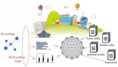
SCs employ a variety of technologies and techniques to accomplish their objectives such as machine learning, information technology (IT), big data, artificial intelligence (AI), learning methodologies, the Internet of Things (IoT), and edge analytics, to name a few. Intelligent transportation and its implementations [3] are important SC components that need intelligent instrumentation and interconnection [1]. Big data analytics has been used to construct and communities [8]. To gather data for smart transportation, different sources of data, such as GPS, video recording, social media, and sensor are used. These data sources also encompass vehicle-sensing data, advanced driver-support data [3], and data from integrated automobiles. Figure 1 depicts a framework for exploitation and use of big data analytics in ITS [2]. The architecture is divided into three sections: data gathering and analysis, intelligent transportation, and the implementation of intelligent transportation.
Machine learning is being used in data science to extract themes and relationships from data for planning and analytics [3]. One of the most prevalent supervised learning techniques is neural networks (NN). For variety and regression, machine learning algorithms need the usage of a classification model. Traffic flow prediction, transportation trip route assessment, public parking forecasting, bus arrival time prediction, and other intelligent transportation systems use unsupervised learning approaches that do not need labelled data. The introduction of deep learning (DL) models is a new trend in current machine learning algorithms [3]. It includes convolutional neural networks, deep constrained Boltzmann machines, conventional neural networks and stackable auto-encoders and other DL models [8]. The latest AI methods for traffic estimates and forecasting, control, mobility and transportation as well as other SC-related applications are used [1]. Intelligent parking systems play a pivotal role not only in mitigating traffic congestion but also in abating environmental pollution. Smart parking constitutes a fundamental component within the framework of smart cities. In an extensive review paper authored by the study [9] the technological intricacies employed in smart parking systems are comprehensively elucidated.
Smart parking system plays a significant part in the smart city transportation system. In densely populated urban areas with limited space, the shortage of parking facilities poses a significant challenge. According to a study, in major cities, almost 30% of vehicles spend most of the time (on average 7.8 minutes) in search of space for parking. This statistic highlights the significant wasting of time and the onset of traffic congestion in metropolitan areas, leading to increased air pollution frustration of people and fuel inefficiency. Traffic congestion, also contributes to elevated fuel consumption rates, resulting in heightened emissions of greenhouse gases thereby exacerbating air pollution [9].
According to the UN report, by 2050, almost 68% of the world population will reside in cities, leading to an increase of approximately 2.9 billion vehicles on the road. This surge in demand challenges the sustainability of current transportation systems, especially with changing travel preferences and evolving policies promoting sustainable transport. Traditional reliance solely on cars or public transport is no longer feasible, giving rise to a more flexible approach to travel behavior. The goal is to accommodate diverse travel intentions without limiting options, including car-sharing for varied needs and using multiple modes of transport for a single purpose. While this flexibility enhances individual satisfaction and offers sustainability options, it complicates the transport system with multiple stakeholders. Managing this complexity requires an integrated transport system, giving rise to the concept of an intelligent/smart transport system (I/STS). The main objective of a STS is to efficiently address transport-related issues, maximizing well-being at both individual and societal levels. Information and communication technologies play a crucial role, allowing seamless connectivity and real-time problem-solving in an automatic, demand-responsive manner. The concept of I/STS is not entirely new but has gained recent momentum, aiming to create a dynamic and adaptive transport system [10-12].
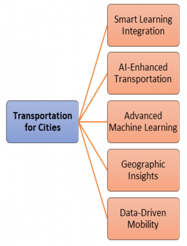
This chapter aims to explore the impact of five driving technology factors, namely machine learning, geographical information systems, big data analytics, deep learning, and AI techniques, on supply chain (SC) transportation plans [1]. It serves as a resource for academics to understand current trends and insights in SC transportation technology development and apply cutting-edge techniques to address industry challenges [2]. While various ways of implementing transportation technologies have been considered, the chapter uniquely addresses SC transportation plans utilizing multiple alternatives [3]. The South Carolina transportation sector faces challenges such as gridlocked roads, route planning difficulties, fleet operational issues, parking authorization modeling problems, and short-term forecasting difficulties due to the surge in urban migration and massive real-time data. To overcome these challenges, it is important to incorporate big data with other technologies [4, 8]. Examples of practical implementations of SC transportation systems are discussed in the study by the study [2]. The chapter provides an in-depth examination of five data-driven viewpoints: strategies for geoformation, approaches to data analytics, machine learning approaches, combined deep learning approaches, and ways to artificial intelligence as cited by the study [1].
The STS comprises two key components: Vehicle to Vehicle (V2V) and Vehicle to Infrastructure (V2I) solutions. V2V solutions improve safety during travel through advanced features such as emergency braking systems, providing alerts about potential collisions such as merging trucks or vehicles in blind spots. V2I solutions utilize sensors on the network of road to determine different variables of traffic such as speed and waiting time [13]. V2V applications comprises features such as blind spot, warning of forward collision, lane change detection, and changes in traffic light and allow assist. V2I warn drivers about entering school zones, roadside workers, and upcoming traffic light changes, including curve speed warning and red-light violation warning [13]. An example case study analyzed by the study [14] focuses on a pilot adaptive system of traffic signal control in Pittsburgh, Pennsylvania. The results demonstrated a 25–40% improvement in traffic flow efficiency and over a 20% reduction in emissions, showcasing the effectiveness of adaptive control of traffic signal in road networks in urban areas.
In order to assess the SC transportation systems with an emphasis on upcoming technologies, the chapter's fundamental goals and contributions were to identify the five driving technical factors that are driving the SC transportation industry [3]. In recent years, the literature survey has been acknowledged as a legitimate method and a critical step in forming a study area, and as such, it has become an integral part of research. As a result, this chapter employs a four-step research technique for collecting and studying the literature: (1) identifying the method of data analysis : evaluate the method by which they analyze the data, and based on the evaluation, same method to be incorporated in our study (2) determining the categorization context: Identify the category of the context (3) obtaining publications as well as designating the field: after identifying method of data analysis and determining categorization, same type of literature searched and (4) assessing [15] as well as evaluating the resources [1].
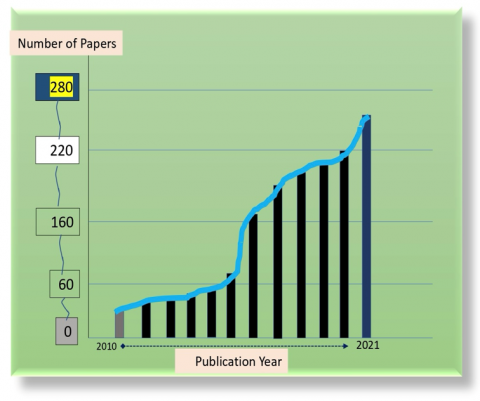
This study provides a literature review at the end that includes over 867 journal research articles and more than 203 references, all within the parameters of this goal. Smart city transportation and comparison are covered in two areas of the literature, according to [3]: (1) an overview of SCT and (2) creating technology for SC mobility [2]. Figure 2 summarizes the extent of the reviews in this Study and summarizes the categorization characteristics and references indicating regions, debate, and research [4]. In the period 2010 to the present, relevant papers have been identified via the use of Google Scholar, IEEE Explore, and Scopus databases, with more publications being discovered by cross-referencing.
Nevertheless, as shown in Figure 3, many publications were discovered between 2017 and 2020; this allowed the authors to restrict their analysis to locate any missing articles, including conventional and emerging items about the keywords. The single study article is also used in this study as the unit of analysis for related articles. They used a list of keywords to gather a significant number of studies to cover research on methods and practices of smart city transportation, utilizes technological innovations for intelligent city transportation implementations [13].
Figure 2. Topics covered in the study (adapted from [7])
Figure 3. Papers distribution based on the year of publication
The integration of literature reviews and empirical studies plays a pivotal role in shaping the design and development of smart cities. A comprehensive literature review provides an in-depth understanding of existing theories, frameworks, and best practices in the realm of urban planning, information technology, and sustainable development. By synthesizing and critically analyzing relevant literature, researchers gain insights into the challenges and opportunities associated with smart city initiatives. Empirical studies, on the other hand, offer valuable real-world data and evidence, contributing to the validation and refinement of theoretical concepts identified in the literature. Through empirical investigations, researchers can assess the effectiveness of smart city technologies, evaluate user experiences, and identify potential barriers to implementation. The synergy between literature reviews and empirical studies facilitates a holistic approach to smart city design, allowing for the integration of theoretical knowledge with practical considerations. This iterative process of informed decision-making empowers urban planners and policymakers to design and implement smart city solutions that are not only technologically advanced but also socially, economically, and environmentally sustainable.
In the era of the Internet of Things (IoT), the susceptibility of Internet-enabled devices to hacking and misuse poses a significant concern. The proliferation of billions of connected devices in various domains, ranging from smart cars to baby monitors, introduces a vast attack surface for potential malicious activities such as unauthorized data access, malware dissemination, and tangible harm induction. In this context, the security of IoT networks becomes paramount for government agencies, businesses, and consumers. While end users share responsibility for IoT security, manufacturers must integrate robust security measures into their devices. The dynamic nature of cybersecurity necessitates an understanding of prevalent IoT security risks, insights gleaned from notable security breaches, and awareness of contemporary IoT security solutions. The collaborative effort between end users and manufacturers is essential to mitigate the evolving threat landscape. This discourse will delve into the infrastructure and technological decisions pivotal for bolstering the security of IoT applications after an examination of the inherent vulnerabilities associated with IoT devices.
The data created by sensors, gadgets, and people in a Smart City must be analyzed to develop conclusions about how to make it a better place to live [4]. It is important to keep all data in a safe place so that it can be quickly accessible and utilized by all stakeholders—governmental and nonprofit alike—to enhance the efficiency of long-term urban problems including security, garbage management, transportation, and traffic [3]. Cloud computing will help in the dismantling of intergovernmental silos, wherein various departments lack a clear channel for communicating and comprehending the data-driven aims of other agencies, a problem often considered to be a major impediment to the implementation of smart cities. Another important element of modern technology is its ability to maintain security measures [4]. Despite its continuous presence, the IoT has (and will continue to have) security issues, which have been well documented.
With the focus on interoperability and connection, SaaS deployment is the foundation of the Smart City's Smart City concept. Within the Smart City framework, this method has the potential to minimize building and organization costs while simultaneously increasing the service delivery efficiency [3]. Customers no longer have to install or operate programs on private servers since software as a service (SaaS) makes it possible for them to be accessed from any location through the Internet of Things. SaaS is growing increasingly popular [15]. IoT has great promise as a platform for new applications in intelligent transportation systems and Smart Cities, but there are many hurdles and problems that must be solved before this technology can be fully realized [1]. This Special Issue is devoted largely to recent discoveries in intelligent and intelligent transportation infrastructure for Internet of things Smart Cities, encompassing both original algorithmic research and innovative implementations, with a particular emphasis on novel applications.
Throughout this part, you will get an overview of SC mobility as well as a review of some important research. Many studies have been conducted to better understand how SC transportation-enabling technologies may be used [4]. A wide array of sensors is used to gather analytics data in smart cities (SCs) [2]. Digital government, smart societies, smart economics, smart environment, and smart mobility are some aspects of SCs mentioned by the writers [16]. In smart mobility ICT and environmental transportation are integrated [3, 13]. An SC's primary emphasis is on the function of ITS in SCs. A smart transportation system may be used for various purposes, including traffic monitoring and alerting drivers to possible dangers [1]. The following topics compare the present evaluation with an overview of SC transportation.
5.1 Intelligent transportation
ITS uses different technologies to examine and manage transportation systems to enhance proficiency and safety. The technologies that are used comprises wireless communication, information processing and controls to enhance the convenience, safety and efficiency of the overall network of surface transportation. To realize these goals, sustainable strategies must be implemented, where information and technology play a pivotal role. Real-time traffic updates and management involve Vehicle to Vehicle (V2V) and Vehicle to Infrastructure (V2I) solutions, enhancing safety through advanced emergency braking systems and monitoring traffic variables using sensors. Demand-responsive public transport provides flexibility by operating without fixed routes and schedules, catering to variable daily demand. Smart ticketing systems, utilizing electronic storage on smart cards or smartphones, eliminate the need for traditional paper tickets, enhancing convenience and efficiency. Ridesharing, involving shared vehicle trips, proves benefits such as cost-saving, less travel time, and environmental protection. The implementation of a Smart Parking System addresses issues related to congestion, fuel consumption, and time wastage by giving real-time information on availability of parking space and allows reservations through a web-based portal as shown in Figure 4. Overall, STS integrates various technological applications to create a seamless and efficient transportation system [17].
A wide range of technologies is used in intelligent transportation systems (ITS), from traffic signals and control systems to parking advice and decision-based information security [2]. IVS for SCs is one example of an intelligent transportation application that the authors have presented as a smart vigilance system (IVS) [3]. Big data technology is one of the five major technical factors we're looking at in our analysis. For the most part, their goal was to use big data technology to address the different challenges posed by the Internet of Things (IoT). Our research focused on how SC transportation may use a combination of the five major technology factors. For us, the most important thing was introducing scholars to current advances in deep learning and data-driven methods that may be used in SCs and transportation designs [4].
We will go through a few recent research on SC transportation designs in this part. The authors studied various transportation designs for SC applications. Various methods were covered by the designs, such as traffic management, shared cars, navigation, and energy management, to name a few. The authors suggested Cloud-based smart parking transit for SCs [3, 5]. A public university was the first place they try this approach, with three levels of architecture [2]: (1) Cloud Tier—services for storing and processing data on the cloud. (2) Web Servers Layer—the link between the mobile apps and cloud tier. Apps may be deployed, and a bundle of apps can be assembled in this environment; and (3) Mobile Applications Tier. Following the user's profile, the server will look for a free parking spot and send back information on the user's route.
Using GPS-enabled buses and smart ticketing, the authors presented a system architecture for an intelligent public transportation system [18]. The bus transmitter module, the bus terminating microcontroller, and the regular service module comprised the system's structure. Using an app on a smartphone, a user was able to identify the bus and estimate its travel time [1]. According to the Singapore Land Transportation System (SLTS) categorization, the section discusses an SC transit system and a methodology for subsystems governance (SLTS) [13]. Parallel traffic management and control was the focus of the researchers' ACP artificial system and numerical experimentation, as well as concurrent execution (PTMS) [3]. Proposals have been made for a new architecture to develop future generation intelligent transportation systems (ITS). For social mobility and agent-based systems, they made use of the Internet of Things (IoT) [13] and cloud computing (cloud computing) [1]. Agent-based traffic management takes advantage of the ever-changing character of traffic conditions by relying on its initiative and flexibility. Agents, as opposed to more conventional techniques of control, are flexible and may be adjusted in response to changes in traffic conditions [4].
Figure 4. Smart parking system [17]
5.2 Traffic management
A few studies on SC traffic control and implementation are reviewed [1]. The goal of traffic managers is to ensure that junctions [2], highways, and motorways are efficient and safe [3]. Road users may benefit from real-time data and projections on density and information of traffic on the adoption of smart technology to minimize negative consequences [1]. Connecting traffic management systems with smart lights and signals may provide valuable information about traffic patterns [15]. To cut vehicle wait times, an intelligent traffic system was designed. In order to gather data on the state of the road, their adaptive system makes use of detectors [4]. The authors have presented an alternative to congestion-aware route optimization for ITS. Authors incorporated SDN technology with the ITS and suggested a grid-built approach for anticipating traffic congestion. The chance of road congestion in a region is inversely related to the square area's average traffic flow [3].
The challenge of predicting traffic flow in SC systems is a critical one. This research focuses on traffic flow forecasts and monitoring alone [1]; thus, it cannot be used to develop holistic solution strategies, including the five technological drivers we identified in our Study of SC transportation applications [2]. As a part of the several processes examined in this study, the researchers' findings are included as one piece of the overall answer. They don't have an integrated strategy to address the SC transportation sector's different concerns, as we did in our research [3].
5.3 Social transportation
Smart transportation systems may benefit from the use of social networking tools. SCs place a high value on the upkeep and enhancement of public transit [19]. On the other hand, new and enhanced features might be expensive to install [4]. Participatory sensing, also known as mobile crowdsensing or crowdfunding, may gather real-time location information utilizing a social-based technique.
Due to the growing rise of online shops, package delivery services are in great demand. The paper's authors developed a mechanism for crowdsourcing public transit and citywide parcel delivery (CPTSs) [2]. CPTS vehicles' idle capacity is to be used in this method. Package delivery may be divided into four distinct states [1]. The delivery strategy finds the best time to deliver all items based on the current status of each box at each time slot [4]. An NP-hard issue was defined, and the authors suggested an efficient heuristic solution utilizing ILP methods [2].
It is critical to ensure that urban transportation is developed to minimize fuel use and traffic congestion [3]. In a platooning application, autonomous cars travel in a train-like way on the same lane [2]. The space between cars in a lane is kept constant [7]. Vehicle platoons may be formed methodically according to the authors of [1]. Fuel consumption is reduced by using an appropriate speed model that is first calculated [1]. After that, a Q-learning model insertion point is created and applied to the platoon's vehicles [4]. In addition, a model for detection of collision was developed for new cars entering the squad due to their strategy, as shown in Figure 5 [3].
Uncrewed aerial vehicles (UAVs) in SC transportation have also been considered. The writers explored UAVs in SC transit, as shown in Figure 6 [8]. Aerial accident reporting agents, aerial speeding fines, airborne police, and aerial traffic signals are just a few examples of UAVs' uses that may be made possible [2]. Using a car service in Smart Cities Sharing economy in smart cities may reduce traffic congestion, environmental pollution and travel costs, and a partial answer to parking issues [1, 20]. An individual's environmental impact may be quantified, and a common incentive method can be used to promote voluntary adherence to sustainable mobility options. WeDoShare, a carpooling framework for sustainable mobility in SCs [21], was also suggested by the authors [3].
Figure 5. Map view [3]
Figure 6. Node connections [8]
5.4 Geo-information and SC transportation
Geo-information and notable developments in South Carolina's transportation system are examined [20]. Some research has been done on geoinformation and geospatial technology in SCs [3]. It was said that geoinformation might be used in SCs to change conventional urban settings into digital ones. The writers examined SC structures and ICT solutions [1]. SCs may benefit from geoinformation and telecommunication (GeoICT) [2]. GeoICT had an important influence in the creation of SCs, according to research provided by the authors. Geo Smart City is a method to geomatics contribution proposed by the specialized authors. Visualization software shows real-time traffic data on colorful maps [4]. For sustainable architecture, the authors highlighted using GeoDesign and how three-dimensional modelling may be used. The authors offered three-dimensional models in geomatics as a method for fusion (GIS) [3] using a three-dimensional simulation as an input, the research team explored the use of different urban models [1], including those for telecommunications, emergency preparedness, and renewable energy generation. It was suggested that a multi-scale 3D-GIS technique might be used to measure and disseminate solar revenue in digital city models [2, 22]. Mobile devices, connections, and telecommunications companies may be used to deliver location-based services (LBS) [1]. For LBS, the location of users and the environment in which they operate are critical considerations [14]. Cybersecurity, disaster risk management, and remote workforce management are possible uses for LBS in SCs [19].
The idea of simultaneous localization and planning is now being explored in GIS (SLAM) [4]. GIS and SLAM technologies may be integrated [3]. For urban transportation systems and electric car recharging [20] recommended using SLAM in power distribution networks (EVs). They implemented a cloud-based SLAM on a GIS infrastructure using vehicle localization to estimate demand. A spatial statistical approach was used to estimate the speed of individual vehicles in the study [15]. Kriging family approaches and spatially weighted regression techniques were used in their approach. The authors recommended utilizing GIS image processing to classify urban sprawl. For the extraction of features, they used Lansat satellite pictures [8]. The authors suggested the latent component characterization of traffic data points. As part of their research, they came up with TraLFM, which stands for Tracing the Human Mobility Patterns of Traffic [23]. They employed three observations: (1) the sequencing of places in the trajectories reflects mobility patterns; (2) mobility composition varies with persons; and (3) trajectories are cyclical and fluctuate with time. The morphologies were analyzed using these three observations [7]. The writers extensively studied VPR recordings and taxi data. The city of Jinan's traffic monitoring system provided the VPR data. The 442 taxi rides in Porto were used to compile the taxi statistics. Results from the experiment suggest that TraLFM can surpass predictions made by existing approaches [1].
5.5 Data-driven transportation
Thanks to the power of data, a new world is being created, which is reshaping our lives [1]. It's reshaping how businesses manufacture things and provide services and how society runs its infrastructure [3, 23]. For many, data is regarded as a valuable digital commodity that may lead to substantial social and economic transformation [1]. To collect data on how we live our daily lives, SCs have enabled the integration of an enormous number of sensor devices, wireless telecommunication technologies, hardware components, and software applications into facilities and services [24]. The mass transit system creates enormous amounts of data daily, both as an intrinsic component of society and an important part of the SC ecosystem. Since mobility data is so vast, varied, and dynamic, data-intensive tasks such as integrating, visualizing, querying and analyzing this data for comprehensive real-time applications are essential [1, 2]. Extensive real-time applications can't use current traditional data processing techniques because of their shortcomings [25].
5.6 Data sources
Technology advancements like the Internet of Things (IoT), social media, and others have increased the number of sources from which massive quantities of data may be created and gathered for use in Intelligent Transportation Systems (ITS) [1, 15]. This means that in the context of ITS, data collection refers to the process of gathering data produced from diverse sources and transferring it through the most appropriate channel(s) [1, 23]. The writers provide light on the many forms and sources of transportation data [24]. The smart card is a mechanism of transportation data collecting [2]. To pay for rides, travelers must utilize smart cards in many urban transportation systems, such as the bus rapid transit (BRT) and rail (among others) [20]. Electronic readers record customers' loading times, origins, and destinations when they utilize (touch) their smart cards [3].
5.7 Transportation and data analytics
Data analysis is the process by which usable information may be discovered, and decision-making processes are aided or bolstered by using data analytics [2]. Today's civilization would be incomplete without transportation [15]. It facilitates the flow of people and products, and it also serves as an engine for economic growth [23, 25]. It is becoming more difficult for transportation companies to find creative solutions for dealing with an ever-growing metropolitan population [3]. Every day new data is generated by sensors (GPS and smartphones), GPS devices (smartphones), and automated fare collecting (AFC) systems are used to track people, infrastructure, and transportation services [26]. Governments and commercial enterprises can acquire helpful information from the massive amounts of created data by using data processing techniques to perform in-depth analyses and monitoring that will help them enhance the products and services quality [1, 20].
Conventional data analysis techniques, such as databases, can't handle such massive amounts of data. Many businesses, including the transportation industry, are already using big data analytics due to its learning ability, infer patterns and optimize [1]. Compared to more conventional approaches, big data has several advantages [3]. Several studies have shown that using a basic model to analyze a huge amount of data is more trustworthy and precise than using a more complex algorithm to analyze a smaller amount of data. The use of big data allows models to grow more complex, which in turn allows researchers to get new insights [2]. It is imperative that the large amount of real-time data in transportation be addressed, as well as the way big data analytics forecasts the current state of ITS components [20, 25]
They created TourSense, an analytics platform that uses city-scale transportation data to track visitors' preferences [23]. A graph-based iterative propagation learning technique was described initially [15]. To better understand and predict future visitor movements, an analytical model of tourist preferences was created [23]. Data from over 5.1 million compared and 462 million journeys gathered via real-world experiments demonstrated that the architecture suggested was successful [3]. Bus timetables and real-time locations in Brasov, Romania have been analyzed using proof-of-concept technology [20, 25]. Their goal was to create a system that would improve municipal transit while also enhancing the city's aesthetic appeal to tourists and locals alike [23]. Data analytics, real-time IoT data distributed technologies, analytics streaming, and other components are all supported by the City Pulse framework, on top of which the system was created [2].
5.8 Machine learning approaches
SC transportation officials and academics have access to a wealth of data that may be used by machine learning, making it a promising option [2, 3]. Applications for SC transportation need a general, dynamic, and ongoing learning methodology [15]. As a result, if we want to enhance the SC transportation efficieny, we need to look at the possibilities of machine learning to provide customized services [25]. Faster machine learning techniques are driven by better algorithms, wider data gathering methods, enhanced information transmission, additional sensor/IO units, in response to the activity of client [26]. New data and predictions are at the heart of machine learning's primary goal much like real-time data [3]. When it comes to analyzing data using machine learning, there are various options [26].
SC transportation challenges have been addressed by researchers using machine learning techniques and methodology [27]. The authors presented research on machine learning-based intelligent transportation [1]. Their research centered on system of traffic management for analyses of detecting and predicting using machine learning [2]. More recently, an increasing number of machine learning research has appeared in the literature [3], particularly with a wide range of machine learning approaches being used to explore a variety of transportation-related issues [1]. For transportation-related applications in SCs, we'll examine machine learning approaches in this section [25]. Transportation for SCs encompasses various applications such as pedestrian traffic projection, scheduling, budgeting, and route suggestions among others.
5.9 Human mobility
A city’s dynamics, planning, and development may be improved by analyzing human mobility data [23]. According to current research, human movement data may be used to identify the city's social structure [2]. The authors suggested a strategy that uses network clustering algorithms based on regional cohesion and regularity [25]. According to their findings, the strongest predictor of urban community structures was the functional relationships between city districts [3].
5.9.1 Density estimation and traffic flow
Predicting traffic metrics may be done in a variety of methods such as machine learning and a coevolutionary neural network are effective in analyzing the on-time performance of airline, data [3], the authors came up with a strategy to forecast flight delay [2]. Regarding prediction accuracy, the ML model came out on top with 89.07 percent [26], while the CNN model came out on top with 89.32 percent accuracy [1]. The prediction of short-term traffic volume in transportation systems was provided, as was a unique hybrid model for predicting the number of passengers moving through a system [3]. Their technique took into account temporality, origin-destination spatiality, periodicity and personality, and historical probability distributions [25]. Even when the change course for traffic classification was doubled, their experimental findings demonstrated excellent effectiveness [1] For short-term traffic forecasting in both every day and exceptional situations, the authors recommended using an online support vector machine for regression [3]. In their trials, they found that the approach they advocated was effective. Traffic streams were identified using Haar cascade classification and deep learning in this research [1]. Authors analyzed and predicted passenger flow in mass transit using GPS monitoring systems [2]. In contrast, the authors suggested a prediction method for traffic flow that uses extreme learning machine [26]. The peaks in highway traffic and nonstationary situations may be predicted using an ERS-ELM technique. The results of the experiments indicated that ERS-ELM had a high prediction accuracy and a short training period [28].
5.9.2 Routing and planning
It is also possible to utilize machine learning to help people plan their travel itineraries and route choices [3]. The authors suggested a bus routing approach to improve the public transportation efficiency by identifying and optimizing area pairings with defective bus routes [2, 25]. To create the patterns of people travelling across areas, the authors used taxi and bus operations [25]. There were 19.2 million taxi journeys and 11 million bus rides recorded in the city of Beijing throughout their experiments [26]. Using a single preprocessing approach for both challenges, they came up with a hybrid system that incorporates both [29]. Trip purpose prediction had an accuracy rate of 81%, while travel mode identification had an accuracy rate of 88% [29]. The authors developed an innovative method for collecting anonymized data from public transportation [30].
A Gaussian-prioritized technique for deploying different transportation routes was presented using neural-networked passenger flow inference; a Gaussian-prioritized technique for deploying different transportation routes was presented [26].
Their experiments found a reduction of 7 to 24% over the current procedures. Deep-travel models were used in the study of route-based methods for predicting journey times in both forward and backward directions [28]. The authors provided an attention mechanism for taxi-carpool platforms to collect background from local trajectories extracted features created by an LLSTM network. In contrast, the authors offered a journey time estimate technique. Deep learning and tree models were used to create a multimodal transport recommendation system that used the weighted mean ensemble approach of CNN and GBDT [26]. The authors suggested a deep (DNN) topology class with entity extracted features to improve categorical variables for travel-mode choice predicting pattern recognition [2]. The convolutional models of the DNN framework allow it to learn distributed representation of category data quickly. Entity integration beat other neural networks and tree-based methods in their studies on the London trip dataset [28].
An LSTM-based GRU impact and structure have been simplified [26], the RNN prediction performance and speed have increased significantly. In comparison to an LSTM, the GRU has just two gates [26], while the LSTM has three [29].
ITGs are crucial infrastructure in SCs since they link surrounding urban areas with smart highways [2]. Difficulties in ETC include optimum route utilization, lengthy outstanding lineups for enabled devices cars (CSVs) systems, longer waiting time, fluctuating delays, congested roads at toll gates and complicated payment procedures [2, 30]. DwaRa, a deep continuing to learn dynamic toll pricing method for ITS, was based on the supposition [2]. DwaRa uses Markov queues to estimate future traffic to keep ITG lanes from becoming overcrowded [25]. The SI-LSTM algorithm is then used to predict the present state of traffic and the weather. When it comes to real-time traffic prediction, LSTM is the best option [26]. A comparative data of merits and demerits of technologies used is summarized in Table 1.
Table 1. Advantages and disadvantages of different technologies
|
Technologies |
Advantages |
Disadvantages |
|
Machine Learning Approaches |
Efficient, Have a greater level of adaptability, AI help in providing eco-friendly technologies, Cost effective 24x7 service, less mistakes |
Lack of expertise, Needs human assistance, Security issues, Hard to detect errors Cybercrimes, Implementation |
|
Data Analytics for Transportation |
Enhance productivity, Fuel efficiency, and less operational costs. |
Lack of expertise. |
|
Geo-Information |
Used for managemnt of natural resources |
Need large amount of data which leads to more errors. |
|
Social Transportation |
You can save money on transport costs, as public transportation is often cheaper than owning a car |
You have less flexibility and convenience, as you have to follow the schedule, route, and capacity of the public transport system |
|
Traffic Management |
Improved traffic management, Enhance safety, Increased efficiency in fuel consumption, Environmentally beneficial |
High implementation and maintenance cost, Technical issues |
The following are the conclusions from the study:
The increasing adoption of Vehicle Automating and Equipment to Achieve (VACS) is attributed to advancements in ICT and sensor technologies.
The integration of Connected Automated Vehicles (CAVs) with VACS is expected to bring about improvements in safety, convenience, and emission reduction.
The collaboration between CAVs and VACS is projected to grow rapidly, with Regular Human-Driven Vehicles (RHVs) maintaining a significant market share.
The collaboration of CAVs and VACS is anticipated to improve highway network functionality, traffic flow, and introduce features like individualized vehicle speed control and lane-change advice.
CAVs are expected to offer benefits such as reduced fuel usage and improved traffic flow efficiency.
There is a noted lack of research on the impact of VACS on traffic conditions and flow management.
Pedestrian safety is identified as a concern, and there is a focus on developing adaptive cruise control systems for pedestrian safety.
The following are the recommendations:
Vehicle-to-pedestrian (V2P) digital communication is suggested as a solution for addressing pedestrian and traffic accidents.
There is a highlighted need for a comprehensive understanding of traffic flow patterns in mixed-vehicle settings with both CAVs and RHVs. This requires extended vehicle flow models and new car-following algorithms at microscopic and macroscopic levels.
Development of pedestrian safety systems using adaptive cruise control.
In summary, the conclusions highlight the potential of CAVs and VACS in improving various aspects of transportation, the need for further research and solutions to address safety concerns, and the importance of understanding traffic flow patterns in the evolving landscape of mixed-vehicle settings.
Vehicle automating and equipment to achieve (VACS) are becoming more popular because of recent developments in information and communications technology (ICT) and associated sensor technologies. Individual safety, simplicity, convenience, and reductions in emissions may all be improved by VACS. VACS is also believed to have the ability to improve global traffic efficiency by controlling traffic.
In the realm of cooperative, ITS, the enhancement of safety for susceptible road users (VRUs) can be achieved through diverse mechanisms. Embedded sensor-based perception systems play a pivotal role in safeguarding VRUs; however, their efficacy is susceptible to visibility conditions and sensor imprecision. Concurrently, vehicle-to-pedestrian (V2P) communication emerges as a viable avenue for bolstering VRU safety, enabling the sharing of information between vehicles and pedestrians. Notwithstanding, the reliability of such information, predominantly grounded in GPS data, significantly influences the efficacy of this solution. Recognizing the complementary attributes of perception and communication methodologies, a synergistic fusion of these approaches is posited as a prospective resolution for VRU safety.
The market share of CAVs and VACS may contribute to enhancements in the functionality of the highway network and the effectiveness of traffic flow. Control systems like speed and lane-change of vehicle may be implemented with this technology. Adaptive cruise control technologies (ACC) and coordinated automated vehicle systems (CACC) are examples of VACS that adjust the features of macroscopic traffic flow in response to traffic flow circumstances, as described in the literature. The lower inter-vehicle headway caused by CAVs may also help enhance traffic flow efficiency. In mixed-autonomy single-lane ring road studies, researchers found that introducing a CAV into the traffic reduced fuel usage by more than 40%. In contrast, research on the impact of new VACS on traffic conditions and their potential for enhancing traffic flow management has been lacking.
Commuters are more susceptible to accidents than drivers. The number of pedestrian fatalities and injuries is disproportionately high. Development of pedestrian safety systems using adaptive cruise control is the current emphasis. There are several impediments and limited time for drivers to respond while operating in a densely populated area. Controversial pedestrians and traffic accidents may be solved using vehicle-to-pedestrian (V2P) digital communication.
This data should be merged with other sources of data, such as the CSP spaces, to get a more comprehensive picture. CSP domains should be digitally reconstructed in the future using a hierarchy urban transportation model that includes physical, ontological, conceptual, and subjective networks. Computer vision and stochastic inference methods might allow a cross-layered network link to show network connectedness. Statistical and Natural Language Processing (NLP) techniques may analyze cross-domain data correlations. It is possible to construct a temporally frequent pattern between Bluetooth intensity and volume of traffic or structure energy consumption with the pedestrian flow. The profusion of traffic data will need the identification and definition of the kinds and quantities of knowledge necessary to perform different services successfully in this hierarchy traffic network architecture.
Future ITS should be used in networked settings in addition to CAVs and RVs due to the growing popularity of VACS. A thorough understanding of flow patterns in mixed-vehicle situations is necessary for ITS since CAVs behave and behave quite differently from RHVs. Vehicle flow models' microscopic and macroscopic levels will have to be extended. New car-following algorithms should be studied at the microscale to add CAV-related features. An ITS link-based control system might be designed using a CF model. When forming a network flow model for city management and planning, the features of CAVs should be taken into account.
[1] Lucic, M.C., Wan, X.P., Ghazzai, H., Massoud, Y. (2020). Leveraging intelligent transportation systems and smart vehicles using crowdsourcing: An overview. Smart Cities, 3(2): 341-361. https://doi.org/10.3390/smartcities3020018
[2] Asefi, H., Shahparvari, S., Chhetri, P. (2019). Integrated Municipal Solid Waste Management under uncertainty: A tri-echelon city logistics and transportation context. Sustainable Cities and Society, 50: 101606. https://doi.org/10.1016/j.scs.2019.101606
[3] Gonella, F. (2019). The smart narrative of a smart city. Frontiers in Sustainable Cities, 1: 9. https://doi.org/10.3389/frsc.2019.00009
[4] Nayyar, A., Paiva, S., Paul, A., Kumar, A. (2021). Social, mobile, analytic and cloud technologies: Intelligent computing for future smart cities. Sustainable Cities and Society, 66: 102676. https://doi.org/10.1016/j.scs.2020.102676
[5] Barrionuevo, J., Berrone, P., Ricart Costa, J.E. (2012). Smart cities, sustainable progress: Opportunities for urban development. IESE Insight, 14: 50-57.
[6] Gohar, M., Muzammal, M., Ur Rahman, A. (2018). SMART TSS: defining transportation system behavior using big data analytics in smart cities. Sustainable Cities and Society, 41: 114-119. https://doi.org/10.1016/j.scs.2018.05.008
[7] Ang, K.L.M., Seng, J.K.P., Ngharamike, E., Ijemaru, G.K. Emerging technologies for smart cities’ transportation: Geo-information, data analytics and machine learning approaches. ISPRS International Journal of Geo-Information, 11(2): 85. https://doi.org/10.3390/ijgi11020085
[8] Manogaran, G., Qudrat-Ullah, H., Kshatriya, B.S.R. (2020). Guest editorial: intelligent transportation systems in smart cities for sustainable environments (SCfSE). IET Intelligent Transport Systems, 14(11): 1351-1352. https://doi.org/10.1049/iet-its.2020.0556
[9] Fahim, A., Hasan, M., Chowdhury. (2021). Smart parking systems: Comprehensive review based on various aspects. Heliyon, 7: e07050. https://doi.org/10.1016/j.heliyon.2021.e07050
[10] Meurs, H., Sharmeen, F., Marchau, V., van der Heijden, R. (2020). Organizing integrated services in mobility-as-a-service systems: principles of alliance formation applied to a MaaS-pilot in the Netherlands. Transportation Research Part A: Policy and Practice, 131: 178-195. https://doi.org/10.1016/j.tra.2019.09.036
[11] Sharmeen, F., Drost, D., Meurs, H. (2020). A business model perspective to understand intra-firm transitions: From traditional to flexible public transport services. Research in transportation economics, 83: 100959. https://doi.org/10.1016/j.retrec.2020.100959
[12] Sharmeen, F., Meurs, H. (2019). The governance of demand-responsive transit systems—a multi-level perspective. In: Finger, M., Audouin, M. (eds) The Governance of Smart Transportation Systems. The Urban Book Series, pp. 207-227. Springer, Cham. https://doi.org/10.1007/978-3-319-96526-0_11
[13] Mangiaracina, R., Perego, A., Salvadori, G., Tumino, A. (2017). A comprehensive view of intelligent transport systems for urban smart mobility. International Journal of Logistics Research and Applications, 20(1): 39-52. https://doi.org/10.1080/13675567.2016.1241220
[14] Smith, S.F., Barlow, G., Xie, X.F., Rubinstein, Z.B. (2013). Surtrac: Scalable urban traffic control. Carnegie Mellon University.
[15] Pau, G., Severino, A., Canale, A. (2019). Special issue “new perspectives in intelligent transportation systems and mobile communications towards a smart cities context”. Future Internet, 11(11): 228. https://doi.org/10.3390/fi11110228
[16] Yin, C.T., Xiong, Z., Chen, H., Wang, J.Y., Cooper, D., David, B. (2015). A literature survey on smart cities. Science China Information Sciences, 58: 1-18. https://doi.org/10.1007/s11432-015-5397-4
[17] Ahmed, S., Rahman, M.S., Rahaman, M.S. (2019). A blockchain-based architecture for integrated smart parking systems. In 2019 IEEE International Conference on Pervasive Computing and Communications Workshops (PerCom Workshops), Kyoto, Japan, pp. 177-182. https://doi.org/10.1109/PERCOMW.2019.8730772
[18] Angelidou, M., Psaltoglou, A., Komninos, N., Kakderi, C., Tsarchopoulos, P., Panori, A. (2017). Enhancing sustainable urban development through smart city applications. Journal of Science and Technology Policy Management, 9(2): 146-169. https://doi.org/10.1108/JSTPM-05-2017-0016
[19] Guevara, L., Auat Cheein, F.A. (2020). The role of 5G technologies: Challenges in smart cities and intelligent transportation systems. Sustainability, 12(16): 6469. https://doi.org/10.3390/su12166469
[20] Yu, M. (2022). Construction of regional intelligent transportation system in smart city road network via 5G network. IEEE Transactions on Intelligent Transportation Systems, 24(2): 2208-2216. https://doi.org/10.1109/tits.2022.3141731
[21] Westraadt, L., Calitz, A. (2020). A modelling framework for integrated smart city planning and management. Sustainable Cities and Society, 63: 102444. https://doi.org/10.1016/j.scs.2020.102444
[22] Chen, Y., Ardila-Gomez, A., Frame, G. (2017). Achieving energy savings by intelligent transportation systems investments in the context of smart cities. Transportation Research Part D: Transport and Environment, 54: 381-396. https://doi.org/10.1016/j.trd.2017.06.008
[23] Yan, H.H., Fang, X.H. (2022). Innovative research on intelligent enterprise management mode under the background of smart city. Wireless Communications and Mobile Computing, 2022: 5225576. https://doi.org/10.1155/2022/5225576
[24] Dinh, D.N., József, R., Dániel, R., Anita, B. (2020). Intelligent total transportation management system for future smart cities. Applied Sciences, 10: 1-31. https://doi.org/10.3390/app10248933
[25] Assaleh, K., AlHamaydeh, M., Choudhary, I. (2015). Modeling nonlinear behavior of Buckling-Restrained Braces via different artificial intelligence methods. Applied Soft Computing, 37: 923-938. https://doi.org/10.1016/j.asoc.2015.09.014
[26] Nguyen, D.D., Rohács, J., Rohács, D., Boros, A. (2020). Intelligent total transportation management system for future smart cities. Applied Sciences, 10(24): 8933. https://doi.org/10.3390/app10248933
[27] Zhang, Y.M., Zhang, G.H., Fierro, R., Yang, Y. (2018). Force-driven traffic simulation for a future connected autonomous vehicle-enabled smart transportation system. IEEE Transactions on Intelligent Transportation Systems, 19(7): 2221-2233. https://doi.org/10.1109/TITS.2017.2787141
[28] Tsai, S.B., Gupta, B.B., Agrawal, D.P., Wu, W.Q., Liu, A.J. (2021). Recent advances in intelligent transportation systems for cloud-enabled smart cities. Journal of Advanced Transportation, 2021: 9792543. https://doi.org/10.1155/2021/9792543
[29] Sumalee, A., Ho, H.W. (2018). Smarter and more connected: future intelligent transportation system. IATSS Research, 42(2): 67-71. https://doi.org/10.1016/j.iatssr.2018.05.005
[30] Ran, B., Jin, P.J., Boyce, D., Qiu, T.Z., Cheng, Y. (2012). Perspectives on future transportation research: Impact of intelligent transportation system technologies on next-generation transportation modeling. Journal of Intelligent Transportation Systems, 16(4): 226-242. https://doi.org/10.1080/15472450.2012.710158