Made Mariada Rijasa | I Made Adhika | Ngakan Ketut Acwin Dwijendra* | I Nyoman Widya Paramadhyaksa
© 2026 The authors. This article is published by IIETA and is licensed under the CC BY 4.0 license (http://creativecommons.org/licenses/by/4.0/).
OPEN ACCESS
Rapid urbanization in Bali threatens the integrity of sacred water architecture, particularly water temples (pura tirtha) that sustain socio-ecological relationships through the Tri Hita Karana philosophy. This study develops and appraises the Sacred Water Urban Integration Model (SWUIM), a literature-derived framework linking Cultural Heritage Preservation, Ecological Function, Urban Planning Integration, and Community Engagement. A sequential mixed-methods design examined 27 sacred water sites in Greater Denpasar through nine intensive case studies, interviews with 45 key informants, ecological observations at 15 sites, a structured survey of 312 respondents, and participatory workshops involving 32 stakeholders. Functional degradation was identified at 22 of 27 sites (81%), spatial discontinuity at 19 sites (70%), and cultural disconnection at 16 sites (59%). At the item level, 89% of respondents endorsed spiritual practice, 76% endorsed water-quality filtration, and 63% endorsed ceremonial water supply as functions of sacred water sites. Along urbanized segments of the Tukad Badung corridor, average riparian width declined from approximately 45 m in the 1960s to 12 m in 2023. Participatory appraisal retained the four SWUIM dimensions while refining their operational content through sacred buffer zones, ecological restoration, hybrid customary–municipal governance, and community-based stewardship. The framework positions sacred water architecture as multifunctional blue-green infrastructure (BGI) and offers a context-sensitive pathway for heritage-led regeneration in rapidly urbanizing sacred-water landscapes.
blue-green infrastructure, Cultural Heritage Preservation, ecosystem services, heritage-led regeneration, sacred water architecture, sustainable urban planning, Tri Hita Karana, water temple typology
The intersection of cultural heritage and sustainable urban development is one of the most pressing challenges facing rapidly urbanizing regions worldwide [1]. In Bali, Indonesia, this challenge is visible in the condition of sacred water architecture, a system of water temples, springs, canals, and ceremonial bathing places that has sustained both spiritual practice and ecological balance for over a millennium [2]. The Historic Urban Landscape (HUL) approach, developed by UNESCO and subsequent scholarship, calls for integrating cultural values, traditional knowledge systems, and natural heritage into urban planning frameworks [1].
Balinese water temples exemplify what Lansing and Fox [2] termed niche construction, a process in which cultural practices and ecological systems co-evolve to produce sustainable human-environment relationships. The subak irrigation system, inscribed on the UNESCO World Heritage List in 2012, demonstrates how the Tri Hita Karana philosophy, which promotes harmony among the spiritual realm, human community, and natural environment, has produced resilient socio-ecological systems [3]. Contemporary urbanization in Denpasar and surrounding areas, however, is fragmenting these sacred landscapes and disrupting water management practices that have proven sustainable over centuries.
Recent scholarship increasingly treats sacred water bodies as multifunctional blue-green infrastructure (BGI), capable of providing ecosystem services while retaining cultural and spiritual significance [4, 5]. These spaces function simultaneously as centers of community life, ecological assets, and providers of regulating, provisioning, and cultural services [6, 7]. BGI refers to networks of natural and semi-natural features that provide water-related ecosystem services; this concept offers a framework for understanding how traditional sacred water architecture can inform contemporary sustainable urban planning [8, 9].
Despite growing recognition of cultural heritage's value in sustainable development, as reflected in Sustainable Development Goal Target 11.4 on protecting cultural and natural heritage [8, 10], practical frameworks for integrating sacred water architecture into urban planning remain underdeveloped. The gap between policy aspiration and implementation is especially acute in Global South contexts, where rapid urbanization intersects with dense cultural heritage [11]. Indigenous knowledge systems, including traditional ecological knowledge (TEK) embedded in sacred site management, offer insights for climate adaptation and sustainable development but are frequently marginalized in technocratic planning processes [10, 12].
This gap is not unique to Bali. Cities across South and Southeast Asia, as well as parts of Latin America and sub-Saharan Africa, contend with comparable tensions between historically-evolved sacred water systems and contemporary infrastructure planning. A transferable model for reading, valuing, and integrating these systems into formal planning would therefore have relevance well beyond the Indonesian context. This research addresses that gap by developing the Sacred Water Urban Integration Model (SWUIM), a preservation framework that synthesizes Balinese water temple typology with contemporary BGI planning. The work contributes in three ways: (1) systematic documentation and analysis of sacred water architecture typologies and their fragmentation patterns in an urban context; (2) empirical assessment of ecosystem services provided by sacred water sites functioning as urban BGI; and (3) an actionable, transferable framework for heritage-led urban regeneration that other rapidly urbanizing regions with comparable sacred-water traditions can adapt and test.
2.1 Heritage-led sustainable development
The integration of cultural heritage into sustainable development frameworks has evolved considerably since the adoption of the 2030 Agenda for Sustainable Development. Culture is not a standalone SDG, but it permeates multiple goals, particularly SDG 11 on sustainable cities and communities [8]. The HUL approach, as set out by Ripp et al. [1], positions heritage systems as enablers of sustainable urban development through value-based, people-centered frameworks that foster inclusive governance, community resilience, and innovation.
Adaptive reuse of cultural heritage buildings and landscapes has become a key strategy for sustainable development, balancing environmental sustainability, social cohesion, and economic development [13, 14]. Religious and sacred heritage nonetheless presents distinct challenges owing to spiritual symbolism, legal protection requirements, and complex institutional governance structures [15]. The economic valuation of cultural ecosystem services provided by heritage sites remains methodologically difficult but is increasingly treated as essential for decision-making and stakeholder engagement [16].
2.2 Blue-green infrastructure and sacred water landscapes
BGI encompasses networks of natural and semi-natural features that provide multiple ecosystem services, particularly water-related functions such as climate regulation, water quality improvement, stormwater management, and biodiversity enhancement [17, 18]. Recent bibliometric analyses indicate that regulating services, particularly climate regulation and water resource management, have become central research foci within BGI scholarship, alongside increasing attention to nature-based solutions and urban resilience [18].
Combining blue (water) and green (vegetation) infrastructure offers synergistic benefits that exceed those of either system alone [7]. Singapore's ABC Waters Program demonstrates how high-density urban contexts can draw on existing water bodies and green spaces to provide multiple ecosystem services while engaging citizens through cultural ecosystem services [19]. Assessing the balance between BGI supply and demand remains critical for optimization, and several studies point to spatial inequalities in access to ecosystem services [6].
Sacred water bodies represent a historically-evolved form of blue infrastructure that predates contemporary BGI concepts while embodying many of its principles [5]. Research on lakes in India shows that both water-filled and dry sacred water bodies provide distinct ecosystem services, with water-filled lakes emphasizing regulating and cultural services [5]. Urban sacred landscapes function as socio-ecological systems in which spiritual, cultural, and ecological values intersect, serving simultaneously as centers of community life and providers of water quality regulation, stormwater retention, and microclimate regulation [4, 20].
2.3 Indigenous knowledge and traditional ecological knowledge
Indigenous knowledge systems, including TEK, offer time-tested approaches to resource management, climate adaptation, and community resilience [21, 22]. Integrating indigenous knowledge into forest management, agricultural practice, and environmental conservation has proven effective for maintaining biodiversity, ensuring responsible resource use, and supporting sustainable livelihoods [10].
Incorporating indigenous knowledge into contemporary planning frameworks nonetheless faces substantial barriers. Strategic Environmental Assessment (SEA) and other planning tools have traditionally focused on quantifiable sustainability metrics, often neglecting the intangible values of sacred landscapes and religious traditions [23]. Global environmental policies, including the Akwé: Kon Guidelines, the United Nations Declaration on the Rights of Indigenous Peoples, and the Intergovernmental Science-Policy Platform on Biodiversity and Ecosystem Services, increasingly recognize indigenous peoples and their knowledge systems, yet implementation gaps persist [10, 24].
The concept of two-eyed seeing, which integrates indigenous knowledge with Western scientific approaches, offers a framework for bridging these epistemological divides [10]. Community participation through Participatory Action Research and related methods shows how indigenous communities can be meaningfully engaged in heritage conservation and environmental management [25]. Digital technologies present both opportunities and risks: they can broaden the inclusion of indigenous knowledge systems, but they can also enable a form of extractive appropriation if implemented without attention to community sovereignty and cultural protocol [26].
2.4 Literature-derived analytical framework for the Sacred Water Urban Integration Model
The initial SWUIM was specified deductively from four bodies of scholarship: the HUL approach [1], BGI and ecosystem-services research [4-7, 17-20], indigenous and TEK [10, 12, 21, 22], and the Balinese Tri Hita Karana and subak traditions [2, 3]. On this basis, four provisional analytical dimensions were defined: (1) Cultural Heritage Preservation, referring to spiritual significance, ritual continuity, cultural meaning, and community stewardship; (2) Ecological Function, referring to regulating, provisioning, and cultural ecosystem services; (3) Urban Planning Integration, referring to incorporation into spatial planning, land-use regulation, and BGI networks; and (4) Community Engagement, referring to participation, customary authority, co-design, and shared stewardship.
At this stage, the four dimensions were treated as literature-derived analytical categories rather than as empirically validated outcomes. They guided field documentation, interview coding, ecosystem-service assessment, and the organization of the participatory workshops. Evidence from the 27-site inventory, nine intensive case studies, and stakeholder workshops was subsequently used to appraise the framework in terms of empirical fit, cultural legitimacy, ecological relevance, and planning feasibility, and to refine its operational content. Figure 1 therefore presents the initial analytical structure of SWUIM, while Section 4.4 reports its participatory appraisal and refinement.
Figure 1. Initial literature-derived analytical structure of the Sacred Water Urban Integration Model (SWUIM)
3.1 Research design, study area, and case selection
This study used a sequential mixed-methods design combining spatial, qualitative, ecological, and survey-based evidence. The study area was the Greater Denpasar metropolitan region in Bali, Indonesia, selected because it contains a concentration of sacred water sites exposed to rapid urbanization pressure. As Bali’s capital and largest urban region, Greater Denpasar provides an appropriate setting for examining the interaction between traditional sacred-water practices and contemporary urban development.
The research proceeded in four phases: (1) identification and documentation of 27 sacred water sites; (2) intensive comparative analysis of nine case-study sites representing varied typologies and fragmentation conditions; (3) socio-ecological assessment of the Tukad Badung river corridor; and (4) participatory appraisal and refinement of the literature-derived SWUIM with traditional leaders, planners, civil-society representatives, and community members.
The 27-site inventory was assembled through purposive, criterion-based selection rather than probability sampling. Sites were included when they were located within Greater Denpasar, contained a physically identifiable water feature associated with a temple, ritual, or customary practice, retained continuing or historically documented sacred-water significance, and could be accessed with the permission of the relevant custodians. The nine intensive case studies were selected using maximum-variation logic to represent different sacred-water typologies, contrasting fragmentation patterns, and varied positions within the Tukad Badung corridor and surrounding urban context. Consequently, the reported prevalence of fragmentation describes the analyzed inventory and should not be interpreted as a statistically representative estimate of all sacred water sites in Greater Denpasar. Figure 2 shows the spatial distribution of the 27 inventoried sites and the nine intensive case-study locations.
3.2 Data collection methods
Spatial data on all 27 sites were collected using GPS coordinates, satellite imagery analysis, and GIS mapping. Historical maps and colonial-era documentation were digitized to assess landscape transformation over time. Spatial analysis included buffer zone delineation, land use change assessment, and connectivity analysis using ArcGIS 10.8.
Ethnographic data were gathered through semi-structured interviews with 45 key informants, including temple priests (pemangku), subak leaders (pekaseh), community elders, and regular worshippers. Interview protocols addressed historical site significance, ritual practice, perceived threats, and community stewardship mechanisms. Participant observation was conducted during major water ceremonies, including Melasti and Tirtayatra.
Ecological data were collected at 15 sacred water sites during the wet and dry seasons. The monitored water-quality parameters were pH, dissolved oxygen, turbidity, nitrate, and phosphate. Hydrological observations addressed flow variation and short-term stormwater retention, while microclimate observations recorded temperature and humidity at sacred sites and nearby built-up comparison locations. Biodiversity observations documented the presence of aquatic and riparian flora and fauna. The ecological component was designed as an exploratory site assessment rather than as a controlled experiment; consequently, the data were summarized descriptively by site and season, and no inferential significance tests or causal estimates are reported.
Stakeholder surveys used structured questionnaires (n = 312) to assess community perceptions of ecosystem services, cultural attachment, and management preferences. Sampling employed stratified random selection across urban, peri-urban, and rural zones, with survey instruments adapted from validated scales in the ecosystem-service perception literature [5]. Of 360 eligible individuals invited to participate, 312 complete questionnaires were retained for analysis, corresponding to a response rate of 86.7%.
The demographic profile of the respondents is presented in Table 1. The sample included 148 male respondents (47.4%) and 164 female respondents (52.6%). Respondents were distributed across four age groups: 18–30 years (72; 23.1%), 31–45 years (96; 30.8%), 46–60 years (88; 28.2%), and over 60 years (56; 17.9%). In terms of residential location, 156 respondents (50.0%) lived in urban areas, 96 (30.8%) in peri-urban areas, and 60 (19.2%) in rural areas. Educational attainment was distributed as secondary education (74; 23.7%), diploma or bachelor's degree (178; 57.1%), and postgraduate degree (60; 19.2%). Regarding their relationship with sacred water sites, 112 respondents (35.9%) were local residents or community members, 88 (28.2%) were regular worshippers or site users, 56 (17.9%) were temple custodians or traditional leaders, and 56 (17.9%) were other community stakeholders.
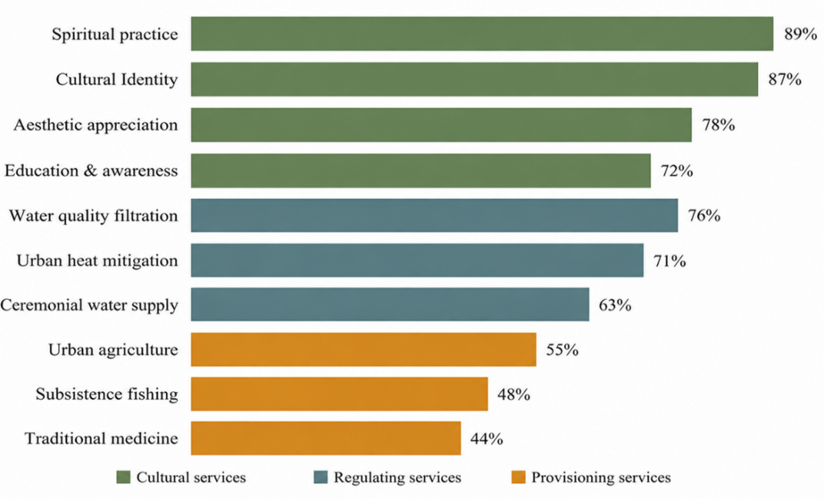
The questionnaire contained ten ecosystem-service recognition items: spiritual practice, cultural identity, aesthetic appreciation, education and awareness, water-quality filtration, urban heat mitigation, ceremonial water supply, urban agriculture, subsistence fishing, and traditional medicine. Responses were recorded using a five-point Likert scale: 1 = strongly disagree to 5 = strongly agree. An item was classified as endorsed when a respondent selected either “agree” or “strongly agree” (scores 4 or 5). Percentages therefore represent item-level endorsement among the 312 valid respondents and are not composite scores for the cultural, regulating, or provisioning domains. Because the items represent distinct ecosystem-service functions rather than a single reflective latent construct, an overall Cronbach's alpha was not interpreted as evidence of scale reliability. Survey data were analyzed descriptively using valid frequencies and percentages. The ten survey items and their corresponding endorsement results were therefore used to describe perceptions of ecosystem-service functions provided by sacred water sites.
Table 1. Profile of survey respondents (n = 312)
|
Characteristic |
Category |
n |
% |
|
Sex |
Male |
148 |
47.4 |
|
Female |
164 |
52.6 |
|
|
Age group |
18–30 years |
72 |
23.1 |
|
31–45 years |
96 |
30.8 |
|
|
46–60 years |
88 |
28.2 |
|
|
>60 years |
56 |
17.9 |
|
|
Residential zone |
Urban |
156 |
50.0 |
|
Peri-urban |
96 |
30.8 |
|
|
Rural |
60 |
19.2 |
|
|
Educational background |
Secondary education |
74 |
23.7 |
|
Diploma/Bachelor's degree |
178 |
57.1 |
|
|
Postgraduate degree |
60 |
19.2 |
|
|
Relationship to sacred water sites |
Local resident/community member |
112 |
35.9 |
|
Regular worshipper/site user |
88 |
28.2 |
|
|
Temple custodian/traditional leader |
56 |
17.9 |
|
|
Other community/stakeholder |
56 |
17.9 |
3.3 Participatory appraisal of Sacred Water Urban Integration Model
Participatory appraisal of SWUIM was conducted with 32 stakeholders purposively recruited through customary institutions, municipal planning offices, civil-society networks, and communities associated with the selected sites. The participants comprised 8 traditional leaders and temple custodians, 8 government planners, 6 NGO or civil-society representatives, and 10 local community members, for a total of 32 participants. Eligibility required direct knowledge of, responsibility for, or regular engagement with at least one case-study site. Workshop sessions applied the four literature-derived dimensions to three sites representing different typologies and fragmentation conditions. Participants worked with site maps, fragmentation summaries, and a four-dimension strategy matrix.
Workshop notes, annotated maps, and strategy matrices were reviewed using four explicit appraisal criteria: empirical fit with site conditions, cultural legitimacy, ecological relevance, and planning feasibility. A dimension was treated as retained when it remained applicable across the three case applications; it was treated as refined when participants proposed additional safeguards, actors, or implementation mechanisms. The exercise was designed as participatory appraisal and operational refinement, not as statistical, predictive, or psychometric validation.
3.4 Analytical framework
Sacred water sites were classified according to physical characteristics, ritual function, and governance structure. Fragmentation was analyzed through three dimensions: spatial discontinuity, functional degradation, and cultural disconnection. Ecosystem services were organized using the Common International Classification of Ecosystem Services (CICES), adapted to the sacred-water context, and grouped into regulating, provisioning, and cultural services. Evidence was synthesized from ecological observations, structured survey responses, interviews, participatory mapping, and photo-elicitation [5]. No monetary valuation or benefit-transfer analysis was undertaken; accordingly, the study reports biophysical indicators and socio-cultural perceptions rather than economic values.
Survey data were analyzed using valid frequencies and item-level percentages. Interview, observation, mapping, and workshop materials were synthesized thematically, using the four literature-derived SWUIM dimensions as deductive categories while allowing site-specific themes to emerge inductively. SDG alignment was assessed against established heritage-SDG methodologies [8, 9], with primary attention to SDG 6.6, SDG 11.4, and SDG 15.1.
4.1 Typology of sacred water architecture and fragmentation patterns
Analysis of the 27 sites identified five source-setting typologies consistent with Figure 3: (1) spring-based petirtaan; (2) well-based petirtaan; (3) mixed-source petirtaan; (4) river-adjacent petirtaan; and (5) man-made watercourse petirtaan. The classification is based primarily on the water source and the site’s spatial relationship to the hydrological system, while ritual function and governance structure are treated as comparative attributes rather than separate typological categories. Across these types, ritual functions include purification, holy-water collection, temple ceremonies, communal healing, and customary water-sharing practices, whereas governance is predominantly organized through desa adat, temple custodians, and community-based maintenance arrangements.
Figure 3. Source-setting typology of sacred water architecture identified across the intensive case-study sites
Three fragmentation patterns emerged across the study sites. Spatial discontinuity, observed at 19 of 27 sites, appears as physical barriers separating sacred water sources from dependent communities and ecosystems: urban encroachment, road construction, and commercial development have created access obstacles, disrupted hydrological connectivity, and fragmented ceremonial routes. Functional degradation, affecting 22 of 27 sites, involves deteriorating water quality, reduced flow rates, and compromised ecological integrity, driven by pollution, groundwater extraction, and altered drainage patterns. Cultural disconnection, present at 16 of 27 sites, reflects weakening traditional governance, reduced ritual practice frequency, and diminished community knowledge of site significance, particularly among younger urban residents. Figure 3 visualizes the five typological categories, while Table 2 summarizes the prevalence, primary drivers, key impacts, and severity levels of the three fragmentation patterns.
Table 2. Fragmentation patterns across study sites
|
Fragmentation Type |
Prevalence (n = 27) |
Primary Drivers |
Key Impacts |
Severity Level |
|
Spatial Discontinuity |
70% (19 sites) |
Road construction, urban encroachment |
Access barriers, hydrological disconnection |
High |
|
Functional Degradation |
81% (22 sites) |
Pollution, groundwater extraction |
Water quality decline, reduced flow |
Critical |
|
Cultural Disconnection |
59% (16 sites) |
Urbanization, generational change |
Weakened governance, reduced rituals |
Moderate-High |
Table 3. Item-level endorsement of ecosystem-service functions provided by sacred water sites
|
Ecosystem-Service Domain |
Survey Item |
Endorsement (%) |
|
Cultural |
Spiritual practice |
89 |
|
Cultural |
Cultural identity |
87 |
|
Cultural |
Aesthetic appreciation |
78 |
|
Cultural |
Education and awareness |
72 |
|
Regulating |
Water-quality filtration |
76 |
|
Regulating |
Urban heat mitigation |
71 |
|
Provisioning |
Ceremonial water supply |
63 |
|
Provisioning |
Urban agriculture |
55 |
|
Provisioning |
Subsistence fishing |
48 |
|
Provisioning |
Traditional medicine |
44 |
4.2 Ecosystem services assessment
Stakeholder survey results are reported as item-level endorsement percentages (n = 312), rather than as composite scores for the three ecosystem-service domains. As summarized in Table 3 and illustrated in Figure 4, the endorsement pattern varied across cultural, regulating, and provisioning functions. Within the cultural domain, spiritual practice received the highest endorsement (89%), followed by cultural identity (87%), aesthetic appreciation (78%), and education and awareness (72%). Within the regulating domain, water-quality filtration was endorsed by 76% of respondents and urban heat mitigation by 71%. Within the provisioning domain, ceremonial water supply was endorsed by 63%, urban agriculture by 55%, subsistence fishing by 48%, and traditional medicine by 44%. The pattern indicates particularly strong recognition of spiritual and cultural functions, while provisioning functions were recognized by smaller proportions of respondents.
Field observations indicated that vegetated sacred sites tended to have lower nitrate and phosphate concentrations than adjacent urban comparison locations, suggesting a potential water-filtration function. Microclimate observations likewise indicated cooler midday conditions within sacred ponds and spring enclosures than in surrounding built-up areas. Sites with intact riparian vegetation also displayed greater short-term retention of monsoon runoff than heavily channelized segments. These findings are reported descriptively because the exploratory ecological design was not intended to support causal inference or site-wide significance testing.
The comparatively lower recognition of provisioning services is consistent with the changing role of sacred water sites within the increasingly urbanized metropolitan environment. Sacred springs are no longer primary sources of domestic water for most urban residents, but they continue to support ceremonial water use, small-scale urban agriculture, subsistence fishing, and traditional uses of aquatic plants for medicine and offerings.
Sacred water sites support spiritual practice, cultural identity, aesthetic appreciation, and environmental education. Observational data recorded approximately 15 to 40 daily ritual visitors at major sites, increasing to approximately 200 to 800 visitors during monthly ceremony days. The strong recognition of cultural identity in the survey was complemented by photo-elicitation findings, which indicated that both well-maintained and degraded sites continued to evoke cultural meaning, although the emotional associations differed according to site condition [5].
4.3 Tukad Badung river corridor as socio-ecological space
The Tukad Badung river corridor, flowing through central Denpasar, illustrates both the potential and the challenges of sacred water architecture functioning as urban BGI. Historical spatial analysis suggests substantial narrowing of the Tukad Badung riparian zone. Comparison of georeferenced historical maps with 2023 spatial imagery indicated that the average mapped riparian width in the analyzed urbanized segments declined from approximately 45 m in the 1960s to approximately 12 m in 2023. These values should be interpreted as approximate spatial indicators because the historical and contemporary sources differ in scale, resolution, and production method.
Despite degradation, the corridor continues to provide ecosystem services. During observations conducted in the 2022 monsoon season, vegetated sacred sites along the corridor displayed greater apparent infiltration and short-term runoff retention than heavily channelized segments. This pattern is treated as indicative rather than as a controlled causal estimate. Rapid biodiversity inventories recorded 23 bird species, eight fish species, and 42 plant species across the observed corridor habitats. These counts represent observed species richness during the study period rather than population estimates, but they nevertheless indicate that the remaining riparian and sacred-water habitats continue to support Ecological Functions within the dense urban matrix.
Community Engagement along the corridor revealed a range of stakeholder interests and knowledge systems. Traditional communities maintain ceremonial relationships with specific river segments, conducting purification ceremonies (melasti) and water blessing rituals (melukat) despite water quality concerns. Younger urban residents express interest in corridor revitalization focused on recreation and aesthetic value. Urban planners recognize the corridor's potential as green infrastructure but face institutional barriers to integrating it with sacred site management.
4.4 Participatory appraisal and refinement of the Sacred Water Urban Integration Model
The literature-derived SWUIM was appraised through participatory design workshops involving 32 stakeholders and applied to three case-study sites representing distinct typologies and fragmentation conditions. All four dimensions were retained across the three applications; however, their operational content was refined in response to stakeholder priorities and site-specific constraints.
Table 4. Outcomes of the participatory appraisal and operational refinement of Sacred Water Urban Integration Model (SWUIM)
|
SWUIM Dimension |
Appraisal Outcome |
Operational Refinement |
|
Cultural Heritage Preservation |
Retained and refined |
Protection of ritual access, ceremonial routes, sacred spatial concepts, and sacred buffer zones |
|
Ecological Function |
Retained and refined |
Water-quality restoration, riparian connectivity, native and sacred-grove vegetation, and stormwater functions |
|
Urban Planning Integration |
Retained and refined |
Formal recognition in spatial plans, integration with blue-green infrastructure (BGI) networks, and cross-agency implementation |
|
Community Engagement |
Retained and refined |
Hybrid customary–municipal governance, shared decision-making, community stewardship, and intergenerational education |
Cultural Heritage Preservation was refined to include protected ritual access, the safeguarding of ceremonial routes, and sacred buffer zones that respect locally recognized spatial concepts. Ecological Function was refined to emphasize water-quality restoration, riparian connectivity, and the use of locally appropriate sacred-grove and native vegetation. Urban Planning Integration was refined to require formal recognition of sacred water sites within spatial plans, BGI networks, and cross-agency implementation arrangements. Community Engagement was refined to move beyond consultation toward hybrid customary–municipal governance, shared decision-making, community stewardship, and intergenerational education. The appraisal outcomes and corresponding operational refinements across the four SWUIM dimensions are summarized in Table 4.
The workshop process did not result in the removal or addition of a core dimension. Instead, it translated the four dimensions into context-specific strategies, including: (1) sacred buffer zones that also function as ecological corridors; (2) hybrid governance structures combining adat authority and municipal responsibility; (3) ecosystem-based water-quality improvement; and (4) culturally controlled heritage-tourism mechanisms capable of supporting maintenance without compromising ritual sanctity. Accordingly, SWUIM is described in this article as stakeholder-appraised and operationally refined rather than statistically validated or conclusively tested.
5.1 Integrating indigenous knowledge with contemporary planning
The SWUIM model demonstrates a practical application of two-eyed seeing principles [10], bridging Balinese TEK embedded in the Tri Hita Karana philosophy with contemporary BGI science. This integration goes beyond tokenistic consultation toward substantive co-design, in which indigenous cosmological concepts inform technical planning decisions. Traditional sacred buffer zone concepts, such as telajakan and lebuh, align with contemporary riparian corridor planning while carrying spiritual significance that strengthens community stewardship.
Power asymmetries nonetheless persist. Urban planning institutions continue to privilege technical-scientific knowledge over traditional wisdom, consistent with Baresi and Russo’s [23] observations of SEA processes. Workshop discussions indicated that traditional leaders perceived themselves as marginalized despite nominal inclusion, suggesting the need for a more fundamental restructuring of decision-making authority rather than merely expanding stakeholder consultation. Evidence from community-led Participatory Action Research in sacred-site management [25] further suggests that genuine power-sharing is more consistent with indigenous knowledge sovereignty than expert-driven consultation alone. Figure 5 illustrates the knowledge integration framework linking TEK and contemporary urban planning through participatory co-design.
5.2 Sacred water sites as blue-green infrastructure
These findings are consistent with international research showing that historically-evolved water management systems can inform contemporary BGI development [7, 19]. As in Singapore's ABC Waters Program in high-density contexts [19], Balinese sacred water architecture shows that even small water bodies can provide ecosystem service benefits disproportionate to their spatial footprint. Cultural ecosystem services, particularly spiritual significance and place attachment, generate community stewardship that supports long-term sustainability, a dimension that technocratic BGI planning tends to undervalue [16, 20].
The three-dimensional fragmentation framework used here, covering spatial, functional, and cultural dimensions, offers more analytical precision than typical habitat fragmentation models. Cultural disconnection is a critical but under-recognized threat: even physically intact sites lose sustainability when traditional governance erodes and intergenerational knowledge transmission fails, a finding consistent with research on indigenous knowledge systems showing that cultural continuity is essential for environmental stewardship [21, 22].
The Tukad Badung corridor analysis reveals tension between ecosystem service provision and sacred landscape integrity. Ecological restoration could enhance regulating services, but traditional communities prioritize ritual purity and spiritual access over ecological metrics. This value plurality calls for negotiated solutions rather than technical optimization, a principle central to the HUL approach [1] but difficult to implement within planning frameworks that require quantifiable outcomes.
Figure 5. Sacred Water Urban Integration Model (SWUIM) knowledge integration framework
Figure 6. Policy and practice implications of the Sacred Water Urban Integration Model (SWUIM) model
5.3 Policy and practice implications
The SWUIM model offers actionable pathways for heritage-led urban regeneration [1, 13, 27]. Key policy recommendations include: (1) formal recognition of sacred water sites as critical urban infrastructure within spatial plans; (2) hybrid governance mechanisms that integrate customary law (adat) with municipal authority; (3) financial instruments, including heritage-led blended finance [28] and payment-for-ecosystem-services schemes that value cultural as well as Ecological Functions; and (4) educational programs that address both traditional knowledge transmission and contemporary sustainability literacy.
Digital technologies present both opportunities and risks. Building Information Modeling (BIM) and digital heritage tools can enhance documentation and tourism management [29], but their application must avoid extractive uses of indigenous knowledge that occur without community consent or benefit [23]. Culturally-grounded digital heritage education, as demonstrated in Indonesia [26], offers a more equitable model that strengthens rather than supplants traditional knowledge systems.
These findings also bear on SDG implementation through culture-based pathways [8, 30]. Global frameworks, including the UN 2030 Agenda and the Paris Agreement, would benefit from fuller acknowledgment of indigenous knowledge's role in climate adaptation and sustainable development [10]. The SWUIM model shows that cultural heritage is not merely protected under SDG 11.4 but can actively enable multiple interconnected goals, a systems perspective that is relevant to integrated sustainable development well beyond Bali. Figure 6 extends these linkages by illustrating how sacred-water heritage can contribute to interconnected pathways across heritage protection, climate action, water management, terrestrial ecosystems, and cross-sectoral partnerships.
5.4 Transferability and global relevance
SWUIM was developed and participatorily appraised in a single metropolitan region; consequently, its transferability should not be assumed. That said, the underlying logic, treating sacred or historically significant water systems as functioning BGI rather than as static heritage objects, is not specific to Bali. Comparable configurations exist in India's temple tanks and sacred groves, in the qanat and sabil water systems of parts of the Middle East and North Africa, in cenotes and sacred springs across Mesoamerica, and in holy wells and river shrines throughout South and East Asia. The transferable contribution of the study lies primarily in the three-dimensional fragmentation framework and the four-dimension SWUIM structure, both of which require adaptation to local typologies, governance systems, and belief structures. Accordingly, transferability is framed as a testable proposition for future comparative research rather than as a settled claim.
5.5 Limitations and future research directions
First, the 27-site inventory was purposive and criterion-based rather than probabilistic. This design enabled comparative analysis across accessible sites with documented sacred-water significance, but it may underrepresent abandoned, inaccessible, or fully absorbed sites. The reported prevalence of spatial discontinuity, functional degradation, and cultural disconnection is therefore specific to the analyzed inventory and should not be generalized as a population estimate for all sacred water sites in Greater Denpasar.
Second, three of the four authors are based in Balinese architecture and engineering programs, and the research team's positioning as cultural insiders shaped both access to sacred sites and the interpretation of ritual significance. This proximity was valuable for building trust with pemangku and community elders, but it also raises the possibility that findings emphasizing the resilience and adaptability of Tri Hita Karana practice reflect, in part, the research team's own investment in that framework. Independent replication by researchers without this positioning would strengthen confidence in the results.
Third, ecosystem service quantification relied primarily on qualitative and perception-based methods rather than continuous ecological monitoring, and the study lacks a genuine pre-urbanization baseline; the 1960s riparian width figures for the Tukad Badung corridor come from historical maps rather than instrumented data, which limits the precision of any claim about the rate of ecological change. Future research should integrate longer-term ecological monitoring, economic valuation using both revealed- and stated-preference methods, and social network analysis of governance dynamics. Climate change impacts on sacred water site hydrology, and their implications for ritual practice, remain a significant knowledge gap.
Finally, this research focused on Greater Denpasar, and transferability to other contexts, in Bali and elsewhere, requires careful attention to local cultural specificities, governance structures, and urbanization patterns; the SWUIM framework's general principles may apply broadly, but implementation details must emerge from place-based co-design rather than direct transplantation. Comparative research across Southeast Asian and other sacred-water contexts could clarify which elements of the framework generalize and which are specific to the Balinese case, and should give particular attention to gendered dimensions of sacred site stewardship, to ensure that integration efforts do not reinforce existing power inequalities within communities.
The participatory appraisal involved 32 stakeholders and three case applications. It provides evidence of contextual relevance, cultural legitimacy, and implementation feasibility, but it does not establish psychometric, predictive, or cross-cultural validity. Further application across additional sites and independent stakeholder groups is therefore required before broader validation can be claimed.
The analysis of 27 sacred water sites in Greater Denpasar identified functional degradation at 22 sites (81%), spatial discontinuity at 19 sites (70%), and cultural disconnection at 16 sites (59%). These findings indicate that the sustainability of sacred water architecture depends not only on the physical survival of water features, but also on hydrological function, ritual continuity, customary governance, and community knowledge.
Sacred water sites can operate as multifunctional BGI by supporting cultural, regulating, and provisioning services. The SWUIM organizes this relationship through four interconnected dimensions: Cultural Heritage Preservation, Ecological Function, Urban Planning Integration, and Community Engagement. The dimensions were derived from the literature and subsequently appraised and operationally refined through site analysis and participatory workshops. The resulting framework should therefore be understood as a context-sensitive and testable planning framework rather than as a universally validated model.
For planning practice, the findings support formal recognition of sacred water sites within spatial plans, protection of ritual and ecological buffer zones, restoration of riparian and water-quality functions, and hybrid governance that shares authority between customary institutions and municipal agencies. Application beyond Bali requires place-based adaptation and comparative testing, particularly because sacred meanings, governance arrangements, and urbanization pressures differ across regions. Within these limits, SWUIM offers a practical pathway for heritage-led urban regeneration that treats cultural continuity, ecological integrity, and community well-being as mutually reinforcing conditions of sustainable development.
The authors are grateful to the temple priests (pemangku), subak leaders (pekaseh), and community members who shared their knowledge and facilitated access to sacred spaces. Institutional support from the Denpasar City Planning Agency and the Bali Provincial Heritage Office is gratefully acknowledged, as is the assistance of the research assistants and students who contributed to data collection. The research was conducted with attention to Balinese cultural protocols and in the spirit of collaborative knowledge creation.
The first author gratefully acknowledges the Doctoral Program in Engineering Science, Faculty of Engineering, Udayana University, and the supervisory team for their academic guidance, critical feedback, and support throughout the research.
Artificial intelligence (AI)-assisted language tools were used exclusively to improve the linguistic quality of the manuscript, including grammar correction, language polishing, and editorial refinement. These tools were not used to formulate the research questions, design the methodology, conduct fieldwork, collect or analyze data, interpret the findings, develop the discussion, or draw the study’s conclusions. All scientific ideas, analyses, interpretations, and substantive revisions were conceived, evaluated, and finalized by the authors. The authors assume full responsibility for the originality, accuracy, and academic integrity of the manuscript.
[1] Ripp, M., Gustafsson, C., Jones, Z., Majumdar, S., Ginzarly, M. (2025). Historic urban landscapes and heritage systems as the basis for sustainable urban development. Land, 14(9): 1783. https://doi.org/10.3390/land14091783
[2] Lansing, J.S., Fox, K.M. (2011). Niche construction on Bali: The gods of the countryside. Philosophical Transactions of the Royal Society B: Biological Sciences, 366(1566): 927-934. https://doi.org/10.1098/rstb.2010.0308
[3] Royo, A., Dharmiasih, W., Arbi, Y. (2016). Forum pekaseh in the management of subak landscape of Catur Angga Batukaru, UNESCO world heritage sites in Bali. In Asian Sacred Natural Sites, Routledge, pp. 140-152.
[4] Abdurahiman, S. (2025). Urban sacred landscapes as social-ecological systems: The case of Tali temple pond ecosystem in Kerala, India. GeoJournal, 90(6): 274. https://doi.org/10.1007/s10708-025-11526-y
[5] Plieninger, T., Thapa, P., Bhaskar, D., Nagendra, H., Torralba, M., Zoderer, B.M. (2022). Disentangling ecosystem services perceptions from blue infrastructure around a rapidly expanding megacity. Landscape and Urban Planning, 222: 104399. https://doi.org/10.1016/j.landurbplan.2022.104399
[6] Dai, X., Wang, L., Tao, M., Huang, C., Sun, J., Wang, S. (2021). Assessing the ecological balance between supply and demand of blue-green infrastructure. Journal of Environmental Management, 288: 112454. https://doi.org/10.1016/j.jenvman.2021.112454
[7] Rozos, E., Makropoulos, C., Maksimović, Č. (2013). Rethinking urban areas: An example of an integrated blue-green approach. Water Science and Technology: Water Supply, 13(6): 1534-1542. https://doi.org/10.2166/ws.2013.140
[8] Sharma, A., Aulakh, R.S. (2023). Sustainable development Goals2030 and management of heritage: Indian and global contexts. Engineering Proceedings, 56(1): 290. https://doi.org/10.3390/ASEC2023-15249
[9] Lucchi, E., Colombo, B. (2025). Multidimensional methodology for sustainable development and heritage preservation. In Climate Mitigation and Adaptation Strategies for Cultural and Natural Heritage: From Conceptualization to Action, pp. 119-161. https://doi.org/10.1016/B978-0-443-34061-1.00006-8
[10] Akalibey, S., Hlaváčková, P., Schneider, J., Fialová, J., Darkwah, S., Ahenkan, A. (2024). Integrating indigenous knowledge and culture in sustainable forest management via global environmental policies. Journal of Forest Science, 70(6): 265-280. https://doi.org/10.17221/20/2024-JFS
[11] Chowdhury, K., Basu, S., Pramanik, M., Plieninger, T. (2025). Blue infrastructure as nature-based solutions for urban sustainability: Evaluating local perceptions from four Indian megacities. Nature-Based Solutions, 7: 100211. https://doi.org/10.1016/j.nbsj.2025.100211
[12] Kahlon, L.K., Singh, R. (2021). Understanding linkages between sustainability and traditional ethnoecological knowledge (TEK): A case study of Paudi Bhuyans in Northern Odisha, India. In Climate Resilience and Environmental Sustainability Approaches: Global Lessons and Local Challenges, Springer Singapore, Singapore, pp. 365-378. https://doi.org/10.1007/978-981-16-0902-2_19
[13] Della Spina, L. (2023). A prefeasibility study for the adaptive reuse of cultural historical landscapes as drivers and enablers of sustainable development. Sustainability, 15(15): 12019. https://doi.org/10.3390/su151512019
[14] Tousi, E., Pancholi, S., Rashid, M.M., Khoo, C.K. (2025). Integrating cultural heritage into smart city development through place making: A systematic review. Urban Science, 9(6): 215. https://doi.org/10.3390/urbansci9060215
[15] Echeverry, D., de Castro, M., Azasu, S. (2025). Adaptive reuse of religious heritage buildings.: A case study of the 16th century convent in Miranda de Ebro. Revista Española de Derecho Canónico, 82(198): 155-172. https://doi.org/10.36576/2660-9541.82.155
[16] Andreucci, M.B. (2019). Economic valuation of urban green infrastructure. Principles and evidence. Economics and Policy of Energy and the Environment, 2018(2): 63-84. https://doi.org/10.3280/EFE2018-002004
[17] Li, J., Xu, H., Ren, M., Duan, J., You, W., Zhou, Y. (2024). Knowledge mapping of cultural ecosystem services applied on blue-green infrastructure—A scientometric review with citespace. Forests, 15(10): 1736. https://doi.org/10.3390/f15101736
[18] Wang, X., Hu, Q., Zhang, R., Sun, C., Wang, M. (2025). Ecosystem services in urban blue-green infrastructure: A bibliometric review. Water, 17(15): 2273. https://doi.org/10.3390/w17152273
[19] Liao, K.H. (2019). The socio-ecological practice of building blue-green infrastructure in high-density cities: What does the ABC waters program in Singapore tell us? Socio-Ecological Practice Research, 1(1): 67-81. https://doi.org/10.1007/s42532-019-00009-3
[20] Makdani, A., Ramani, S. (2023). Enquire into role played by architecture elements in shaping people’s place attachment narratives: Case of sacred pond in Narayan Sarovar, Kutch, Gujarat, India. In International Conference CITAA Cities Identity Through Architecture and Arts, Springer Nature Switzerland, Cham, pp. 203-210. https://doi.org/10.1007/978-3-031-60641-0_19
[21] Yerramilli, A.R. (2025). Indigenous knowledge and sustainable development: The Indian story. In Revaluation and Preservation of Indigenous Knowledge Systems in Modern Society, IGI Global Scientific Publishing, pp. 465-490. https://doi.org/10.4018/979-8-3693-7964-6.ch023
[22] Alam, M. (2025). Preserving cultural heritage and empowering indigenous communities for sustainable development in Fiji. Social Sciences & Humanities Open, 12: 101760. https://doi.org/10.1016/j.ssaho.2025.101760
[23] Baresi, U., Russo, A. (2026). Strategic environmental assessment as a policy tool to give voice to religious and spiritual views, and to prevent ‘n AI colonialism’ in twenty-first century spatial planning. In Urban Ecotheology in the Age of Technology, Springer Nature Switzerland, Cham, pp. 257-278. https://doi.org/10.1007/978-3-032-13206-2_14
[24] Ölçer Özünel, E. (2017). An action plan for people, planet and prosperity: The critical approach to the sustainable development goals and safeguarding of intangible cultural heritage. Milli Folklor, 2017(116): 18-32.
[25] Dzerefos, C.M. (2026). Finding compromise and cooperation through PAR for spiritual rituals in the Magaliesberg biosphere reserve, South Africa. Action Research. https://doi.org/10.1177/14767503261418529
[26] Mansyur, A.I., Supriatna, N., Komalasari, K. (2025). Digital cultural heritage education: Using technology to improve instruction for the SDGs in Lombok, Indonesia. In 2025 World Engineering Education Forum-Global Engineering Deans Council (WEEF-GEDC), Daegu, Korea, Republic of, pp. 1-2. https://doi.org/10.1109/WEEF-GEDC66748.2025.11256368
[27] Tousi, E., Pancholi, S., Rashid, M.M., Khoo, C.K. (2025). Cultural heritage sites as a facilitator for place making in the context of smart city: The case of Geelong. Urban Science, 9(9): 337. https://doi.org/10.3390/urbansci9090337
[28] Burnham, B. (2022). A blended finance framework for heritage-led urban regeneration. Land, 11(8): 1154. https://doi.org/10.3390/land11081154
[29] Liu, Z., Zhang, M., Osmani, M. (2023). Building information modelling (BIM) driven sustainable cultural heritage tourism. Buildings, 13(8): 1925. https://doi.org/10.3390/buildings13081925
[30] Bhattacharya, S., Sachdev, B.K. (2024). Indigenous knowledge systems for sustainable development, green trade, sustainable cities and commodities, and climate justice education. In Inclusivity and Indigeneity in Education for Sustainable Development, IGI Global Scientific Publishing, pp. 25-48. https://doi.org/10.4018/979-8-3693-2802-6.ch003