Hiba M. M. Witwit*![]() | Rashaa Malik Musa
| Rashaa Malik Musa![]()
© 2025 The authors. This article is published by IIETA and is licensed under the CC BY 4.0 license (http://creativecommons.org/licenses/by/4.0/).
OPEN ACCESS
This study analyzes the level of accessibility of riverine public spaces, as a fundamental component of sustainable and equitable urban structures, highlighting the Hillah Corniche as a practical model. The determinants of accessibility to riverine public spaces are based on their vital role in promoting spatial justice, urban vitality, and social sustainability in cities. The focus was exerted on a set of urban variables affecting accessibility, including: the spatial dispersion of public spaces, spatial proximity, means and modes of access, transportation and mobility, diversity of activities and facilities, and traffic flow. An analytical approach based on Geographic Information Systems (GIS) tools and descriptive spatial analysis of occupancy indicators and infrastructure efficiency was applied. The research was based on the main hypothesis that accessibility is a crucial factor in improving the efficient use of public spaces. The results showed that enhancing accessibility to public spaces depends extremely to a large extent on the equitable spatial distribution of these spaces, the integration of transportation networks, the multiplicity of access options, and the functional diversity within the site. The Accessibility Index (AI) was found 61.3%. To increase AI, many enhancements may be achieved, including high levels of vitality in these spaces, which requires designing highly efficient roads, providing organized parking spaces, and ensuring a safe and private environment that is compatible with the local social fabric. The study recommended activating the public transportation network, intensifying various activities within the spaces, and functionally integrating them with residential neighborhoods. This would contribute to increasing AI and occupancy rates and narrowing the gap in access to public space among different segments of society.
riverine public spaces, transportation and accessibility, reported barriers, activity diversity, urban sustainability, spatial proximity
With increasing urbanization and urban expansion, public spaces have become increasingly important in improving the quality of urban life, particularly those overlooking riverfronts, which provide dynamic environments that foster social interaction and recreational activities. Despite their importance, these spaces face significant challenges, most notably poor accessibility, which reduces their effectiveness as active urban elements and limits their role in supporting urban sustainability. Accessibility is not just a physical element; it is a fundamental component of the vibrancy of public space, reflecting the extent to which these spaces attract individuals and stimulate various activities [1, 2]. Studies have shown that spaces with good access lead to increased social and economic activity, while isolated spaces suffer from weak use and interaction. In this context, public spaces are defined as open spaces freely accessible to the public, such as squares, parks, and riverfronts, which play a key role in promoting urban sustainability [3, 4]. They are the main public open spaces in the city and play a vital role in urban development. With increasing urban pressure. Decision makers have begun to recognize the need to develop planning strategies that enhance the integration of riverfront spaces with the rest of the city, contributing to a more vibrant and sustainable environment [5]. However, problems remain related to riverbank connectivity and poor transportation infrastructure, which lead to inefficient access to these spaces and reduces their potential use. Studies have indicated that cities with vibrant riverfronts provide more conducive living and working environments, enhancing quality of life and urban well-being [6, 7]. Improved accessibility to urban riverfront environments constitutes a key driver of spatial vitality and contributes to the quality of urban development. Here, urban public spaces refer to publicly open areas that can be used without restriction by different social groups, irrespective of gender, race, age, or socio-economic status. This category covers central urban places (e.g., squares and parks) and linear public corridors (e.g., streets and sidewalks) [3, 4, 8]. Other studies similarly conceptualize public space as open urban environments—particularly streets and parks—that structure daily public activity: squares, waterfronts, and other areas outside private property, whether for residential or commercial use, according to reference [9]. While the concept of blue spaces overlaps with green spaces, it is noticeable that blue spaces provide different types of benefits to users. They are experienced in different ways; for example, running water has acoustic qualities that can be used by urban planners to create relaxing soundscapes [10]. Cities with high biophilia are ideal places to live, work, and travel, as they significantly positively impact the well-being of residents, particularly in urban areas overlooking waterfronts [6, 7]. However, many cities, during rapid urbanization processes, face a range of pressing issues, such as limited waterfront functionality, poor street biophilia, and inefficient resource use. With the growing global interest in sustainable development and building environmentally friendly cities, many urban areas have begun to recognize the importance of effective planning and optimal use of the unique resources provided by waterfronts. This realization aims to create more vibrant urban water spaces that meet residents' demands for a high-quality living environment [5]. Riverfronts are places at which water and land meet within a city. Field observations and surveys were conducted in three Chinese cities to assess the social performance of urban waterfront places. The findings reflect use patterns, such as tourism, leisure, and social grouping, emphasizing the necessity of spatial stratification in design. The findings provide recommendations for developing more sustainable, resilient, and inclusive waterfront habitats [11]. Waterways are spaces visited by people for various recreational purposes, attracting a variety of wildlife such as fish and ducks, making them more attractive than traditional spaces. Although waterways offer significant environmental and economic benefits, this study focuses specifically on the social benefits these spaces provide in enhancing social interaction and the quality of urban life [12].
Accordingly, this study aims to analyze the accessibility of urban river spaces and its impact on their vitality, using Geographic Information Systems (GIS) and urban simulation models to assess the relationship between spatial planning, accessibility, and levels of social activity. In doing so, the study seeks to provide design strategies that support the achievement of more integrated and vibrant river spaces, enhancing urban integration and achieving sustainable development.
1.1 Variables affecting access to public spaces
Accessibility to public spaces is a crucial factor in achieving urban vitality. This concept has evolved from being associated with transportation and mobility to becoming an essential element in ensuring social interaction and achieving urban justice. It was noted that accessible public space is a major index that allows a diverse group of individuals to use it freely, ensuring functional integration that enhances its attractiveness and ability to attract diverse activities [13]. Urban vitality is a measure of the quality of life within a city, as it is linked to the extent to which public spaces are used and the extent to which individuals interact with them. This has been emphasized by Wendt [14] as a key indicator for creating sustainable and dynamic cities. However, poor accessibility is a factor that limits the use of public spaces, diminishing their role in supporting active urban life. The success of public spaces depends on their accessibility, the variety of activities held there, and the level of comfort they provide to users. This confirms that the design of public spaces must take into account diverse user requirements. Similarly, the effective access to public spaces requires addressing several determinants, such as crowding, comfort levels, variety of activities, visual appeal, and quality of maintenance [15]. Therefore, improving accessibility to these spaces is not limited to enhancing mobility within them, but also includes improving their design to take into account the needs of different groups, such as children, the elderly, and people with disabilities, which contribute to achieving more inclusive and equitable urban environments [16]. Riverfront areas are one of the most prominent urban spaces affected by accessibility. Many cities have experienced unbalanced development patterns, concentrated on one side of the river, resulting in an unequal distribution of urban resources [17]. This disparity has prompted the need to expand transportation networks and achieve more balanced urban integration between the two banks of the river [18]. With increasing urbanization, public spaces available for outdoor activities have diminished, making riverfronts a strategic option for enhancing urban quality of life. This is due to their diverse environmental resources and their ability to provide attractive, multi-use natural environments. This raises the importance of improving their accessibility to ensure maximum utilization. However, many of these spaces still face accessibility challenges, as they are often located on the outskirts of cities, where they face complex transportation systems and inadequate infrastructure. Improving accessibility cannot be viewed simply as a means of facilitating movement. Rather, it is a key element in enhancing the vitality of riverine spaces, contributing to their active use by residents and transforming them into vital social and economic centers. Studies indicate that integrating sustainable transportation strategies with riverfront planning can contribute to more integrated urban environments that enhance social cohesion and support sustainable urban development [5]. Therefore, achieving more balanced urban integration across river banks requires adopting a holistic approach that focuses on improving accessibility, not only as a functional factor, but as a fundamental pillar in building more dynamic and sustainable cities. The accessibility of a public space can be judged by its connections to its surroundings, both visually and physically. A successful public space is easy to reach and access. It can be seen from a distance and up close [15]. Furthermore, street type is a powerful factor in both social interaction and accessibility. For example, local streets are preferred over main arteries, and the presence of sidewalks is seen as a way to encourage connections between private and public spaces [19]. The design of pedestrian-friendly urban environments requires pavement-oriented architecture that promotes visual and functional continuity with the surrounding urban sprawl, and that considers human scale and fine architectural detail, contributing to an improved pedestrian experience and enhanced quality of space. The availability of public transportation, including public ports dedicated to river travel, along with the ownership of private vehicles, is a factor that enhance access to public spaces, contributing to their better integration within the urban structure and enhancing their use. In organizing their movement within the city network, the users rely on a number of mechanisms, including choosing the easiest route to reach the destination [20]. Paths are essential elements that drive daily use in cities, as city dwellers spend most of their outdoor time navigating these urban paths. Accessibility increases the likelihood of using space, and thus, accessibility can be linked to the concept of legibility in functional terms. Permeability and the number of connections play an important role in generating and increasing pedestrian movement to safe urban spaces. The more these connections are, the greater the permeability. This permeability will lead to increased pedestrian density and the flow of more people to public squares and places where activities take place. It's worth noting here that the presence of people within spaces requires the provision of a supportive structure, such as rest areas, seating areas, water fountains, shading, and landscaping, as well as determining the speed limit of streets leading to spaces. Permeability and the number of connections play an important role in generating and increasing pedestrian traffic to safe urban spaces. This permeability will lead to increased pedestrian density and a greater flow of people into public squares and areas where activities are located [21, 22]. As many urban theorists highlight, poor accessibility is one of the major barriers affecting the use of public spaces. However, once public space is accessible, other factors also play a role in determining and influencing the quality of public space, which in turn leads to increased use by citizens. Others highlight that the factors influencing patterns of public-space use vary depending on the classification adopted. However, the effectiveness of a public space is commonly evaluated through four core attributes: (1) accessibility and connectivity, (2) capacity to accommodate diverse activities, (3) comfort and a favorable physical image, and (4) social value as a setting that encourages public encounter and exchange. Accessibility to public spaces is measured by their integration with their urban surroundings, both in terms of visual and physical connectivity. A successful public space is one that is easy to access and navigate, and is visible from both near and far distances [5]. Accessibility, both physical and psychological, is a fundamental principle in the planning of public spaces, as these spaces should be integrated into urban planning processes as key components that contribute to providing more integrated and inclusive urban environments [23]. Accessibility to public spaces can be measured as an indicator of their distribution within the urban fabric. It is preferable to have them distributed evenly rather than concentrated in limited areas, which enhances residents' effective access to them. In addition, street type is a factor influencing both social interaction and accessibility to public spaces. For example, local streets are preferred over main roads, and the presence of sidewalks is seen as an element that encourages strengthening the links between private and public spaces [19]. Usually pedestrians seek an architectural environment that is oriented towards sidewalks, creates visual and spatial continuity, is diverse, and has scales and elements designed to suit humans [24]. Accessibility to urban public green spaces has been extensively explored, with distance being a key indicator of this accessibility. The frequency of green space use tends to decrease with increasing distance [25]. Proximity is identified as a critical determinant of use [26]. In addition, the availability of public transportation or the ownership of private vehicles is a factor that contributes to enhancing access to public spaces [20]. On the other hand, Harnik [27] emphasized that public space should be accessible to everyone regardless of their place of residence, physical abilities, or financial means. It should also be distributed in a way that ensures that all residents are served fairly. Furthermore, accessibility should not be based on a stereotype of able-bodied adults, but should take into account elderly people using crutches, mothers pushing strollers, and children riding bicycles. There is a positive relationship between accessibility to public spaces and levels of use, as well-used public spaces are usually centrally located within the neighbourhood, close to residential units, have a clear view from the street, and are adjacent to other public uses. Based on these discussions, and in line with the primary objective of this study, spatial distribution, proximity, and accessibility were identified as key variables that contribute to assessing the accessibility of public spaces. The previously reported study focuses on spatial equity in park provision [28]. Although a wide range of indicators has been applied to measure park accessibility, relatively few studies have explicitly examined how travel behavior shapes accessibility outcomes. To address this limitation, the authors proposed a traffic behavior–based Gaussian two-step floating catchment area model (TB-G2SFCA) to evaluate park-access equity in the Nanjing region, and they employed the Local Moran’s I statistic to identify spatial clustering while interpreting equity patterns. Their results indicate that: (1) conventional single-mode approaches may misrepresent park accessibility, whereas TB-G2SFCA offers a more behaviorally realistic assessment; (2) communities south of the Yangtze River generally experience better park service levels than those in the northern areas; and (3) accessibility inequities are comparatively most pronounced in three suburban districts.
The research relied on the descriptive analytical approach through observation and adults’ questionnaires and reliance on GIS data in studying the possibility of access to river public spaces. The lack of a clear vision of public river spaces in Hillah City leads to poor accessibility due to deficiencies in infrastructure and distribution of activities, which negatively impacts occupancy levels and effective use, and raises a question about how accessibility determinants affect the occupancy level of public river spaces in Hillah.
Studies show a positive relationship between accessibility to public space and its use. Public spaces with high use rates are typically centrally located within urban neighbourhoods, close to residential units, have a clear view from surrounding streets, and are integrated with other nearby public uses. Based on the previous discussions, and in accordance with the main objectives of this study, dispersion, proximity, access methods and modes, as well as diversity of functions and safety, were identified as key variables contributing to assessing the accessibility of public spaces. Among these, proximity and diversity of functions are the most important, serving as a necessary condition for measuring accessibility and closely linked to urban patterns and urban planning decisions [29]. Short-term accessibility to public spaces is of great importance to citizens, especially vulnerable groups with limited mobility. These findings may help urban planners and policymakers develop more reasonable policies and plans to increase spatial equity for parks in urban settings. Another data source used in the study was the results of an assessment of urban park space quality, conducted based on the methodology proposed by Zhang et al. [30].
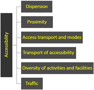
Figure 1. Flowchart of study variables
In general, this is an audit of urban spaces in parks conducted within five thematic categories including the evaluation of
1. Accessibility (sidewalks, parking, public transport stations)
2. Variations in activities and facilities
3. Park facilities (presence of public toilets, drinking water sources, park lighting)
4. Aesthetic features (including the quality of landscape architecture)
5. Aspects that negatively impact the perception of park Attractiveness (vandalism, dirt, clutter, neglect, a sense of danger, etc.)
Figure 1 shows the effective variables on the urban riverine spaces accessibility. Table 1 provides the operational definitions, indicators, and measurement procedures for each variable.
Table 1. The Detailed analysis of access to public spaces
|
Variables |
Description |
Measurement Methodology |
|
Spatial dispersion of public spaces |
It refers to the pattern of distribution of public spaces and their geographical spread to achieve equitable access, as the spatial concentration or dispersion of these spaces affects the levels of community benefit. |
Geographic distribution analysis using GIS and travel time indicators based on adults questionnaires (monthly from Jan to Dec 2024) and spatial modelling. |
|
Spatial proximity |
It measures the extent to which the distance between residential areas and public spaces affects accessibility, as spatial proximity plays a pivotal role in enhancing daily use rates of spaces. |
Analysis of direct visibility of public spaces from residential units using GIS techniques, in addition to satisfaction surveys. |
|
Access methods and modes |
Refer to the impact of road and sidewalk infrastructure on access to public spaces, with the quality of street design. They are playing a fundamental role in achieving safe and smooth access. |
Assessing the quality of streets and sidewalks using field surveys, GIS accessibility measurements, and traffic flow analysis. |
|
Transportation and accessibility |
Public and private transportation systems are essential for enhancing access to public spaces, as the efficiency of these systems contributes to improving urban integration and supporting sustainable mobility. |
Measuring Car Ownership Rate and Its Impact on Accessibility based on (adults Questionnaire, monthly from Jan to Dec 2024). |
|
Diversity of activities and facilities |
The diversity of facilities and activities within public spaces affects their attractiveness and effectiveness in meeting users' needs, thus enhancing their social and recreational functions. |
Conduct field studies to monitor the types of activities and facilities available, and analyse their integration using observation and user interview methodology (monthly from Jan to Dec 2024). |
|
Traffic |
Traffic density and speed affect access to public spaces and the safety of users. |
Analyse traffic flows and driving behaviour using field surveys. |
2.1 Temporal and spatial boundaries
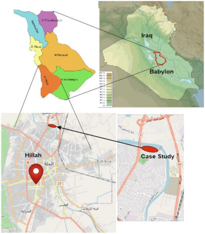
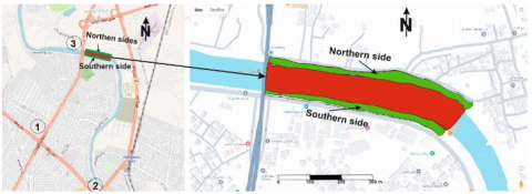
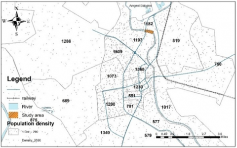
The study is spatially limited to the Hillah Corniche, a model for public river spaces located on the banks of Hillah River. It includes a comparative analysis of the northern and southern banks within the city's urban area. Temporally, the study covers the year 2025, including field observations and data analysis related to public space occupancy and access patterns.
2.2 Study area description
A piece of the Hillah Corniche in Babylon Governorate, Iraq, was selected. This is a popular attraction among both city residents and people from nearby communities. It is located about one mile from Hillah's city center. The location has lately undergone major infrastructure and public service development, establishing itself as a landmark in Hillah. The location will be a public space in the shape of a strip on both sides of the Hillah River, with various activities such as a boat dock, the Blue Bridge, and gathering spots, as well as green spaces and lounging areas directly viewing the river.
The space is surrounded by a wall made of iron railings to protect its occupants, with some entrances and exits to and from the premises. The site is rectangular in shape, 600 meters long and 120 meters wide (including the river), with a total area of 72,000 square meters stretching from the Bith Bridge to the Blue Bridge. The southern river bank is marked by its direct link to the city center, which is bustling with activity and home to the majority of inhabitants' favorite attractions, particularly the Babylon Tourist Hotel. The northern bank is distinguished by tranquility and solitude. The location of the study area is shown in Figure 2.
Figure 2. Location map of Hillah Corniche Site, based on the GIS, Google maps and map of Iraq [31-34]
2.3 Architectural history
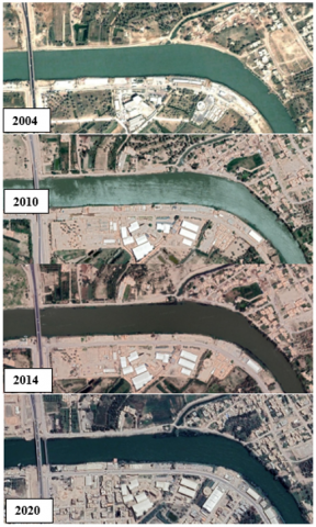
Despite the urban movement carried out by the Ministry of Culture and Tourism in 1987 to test the site for the construction of the hotel (Babylon Tourist Hotel) due to its strategic location and proximity to the ancient city of Babylon and its wide river view, the area was suffering from great isolation at first, specifically in 2004. Some leisure activities, such as private cafes on the river bank, began in 2011 and served as the beginnings of a population and housing attraction. Then, from 2014 to 2020, the situation remained unchanged due to the local government's lack of control, resulting in more slums, visual distortion, and the entire closure of the riverside, as depicted in the images of Figure 3.
Figure 3. Aerial photos are based on Google Earth in 2004-2020
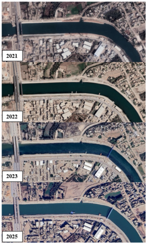
Major urban development began in 2021 when the Ministry of Water Resources designed and launched the Hillah Corniche development project, which involved reshaping and enhancing the area’s features. This project included urban upgrades to surrounding neighbourhoods and improvements in transportation by constructing a second road axis parallel to the Bith Bridge. Initial work in the study area was carried out as a pilot model within the first year and then extended along the river. In 2023, a pedestrian bridge—known as the Blue Space Bridge—was added, becoming a significant landmark and a point of attraction for local residents. Additionally, a boat marina was introduced during 2024–2025 to promote river transportation and recreational activities, as illustrated in Figure 4.
Figure 4. Aerial photos are based on Google Earth in 2021-2025
2.4 Affecting variables of accessibility spatial distribution of public spaces
It refers to the pattern of distribution of public spaces and the amount to which they are geographically dispersed in order to provide fair access, where the spatial concentration or dispersion of these areas influences levels of community benefit.
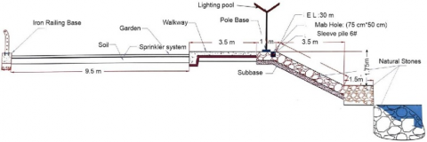
All activities have been dispersed equally, allowing visitors to go freely to a specified spot. This is accomplished by organizing the activities in a linear arrangement, 20 meters wide, along the riverbank with a set cross-section divided into:
(1) A green strip 9.5 meters wide,
(2) A multi-use pedestrian path 3.5 meters wide for walking, jogging, and cycling,
(3) seating areas along the river, 1 meter wide,
(4) Stone terraces overlooking the river, 3.5 meters wide,
(5) Parking areas along the river outside the site’s boundary,
(6) A surrounding fence with entry and exit gates.
As shown in Figure 5.
Figure 5. Construction details of the Corniche, water resources ministry of Iraq report, 2021
2.4.1 Spatial proximity
It assesses the impact of the distance between residential areas and public spaces on accessibility, as spatial proximity is critical in raising daily usage rates in these locations. In general, the site is distinguished by its proximity to residential neighborhoods, as it is part of the city of Hillah's master plan. In terms of connectivity, the river's southern bank is in direct contact with the city as a result of urban expansion on that side. In contrast, the opposing northern side is less connected to its surroundings, consisting primarily of public buildings, open farmland, or vacant spaces. These are indicated in Figure 6.
Figure 6. Residential areas surrounding the case study, based on Google Earth, 2025
2.4.2 Access methods and modes
Figure 7. Source of the transport and road contract
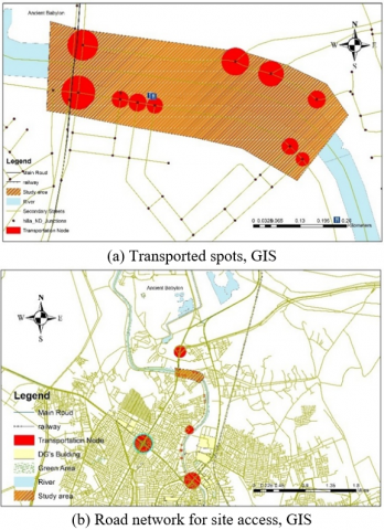
Field surveys were used to assess roadway and pedestrian walkway quality, as well as accessibility assessments using GIS and traffic flow analysis. The transportation network of Hillah was examined in general, with an emphasis on the area around the study site. Main roads, subsidiary roads, and transportation hubs were identified. Currently, three important traffic nodes are within 1 km of the site: 1. Al-Thawra Intersection to the south-west, 2. Bab Al-Hussein Intersection to the south, 3. the overpasses leading to the international highway to the north and the area surrounding of Bith Bridge, as shown in Figures 6 and 7. In addition, all smaller nodes along secondary highways and residential districts leading to the site were identified.
The key transportation nodes located on the main highways present a barrier to site accessibility, particularly because these routes are rather narrow, producing traffic congestion and even paralysis during special events.
In general, there are several modes of access to the site: private transportation is commonly used for medium and long distances, while nearby areas can access the site on foot—within approximately 500 meters—for neighborhoods with direct connectivity to the site.
2.4.3 Transportation and mobility
Measuring car ownership rates and their effects on accessibility:
According to the survey, there are no public transportation lines, forcing residents to rely solely on private vehicles (personally owned cars) or taxi services. Recently, water transit has been launched to reduce traffic congestion to and from the site, highlighting one of the property's deficiencies.
2.4.4 Diversification of activities and facilities
Field surveys were performed to observe the types of activities and available facilities. The area has recently seen substantial expansion and diversification in terms of activities and events, which will be addressed in two primary scenarios:
1st Scenario
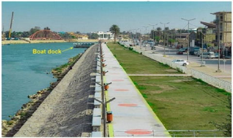
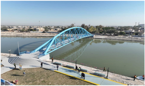
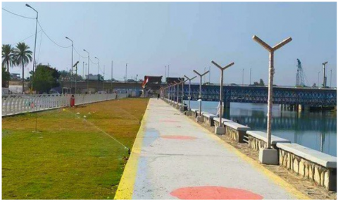
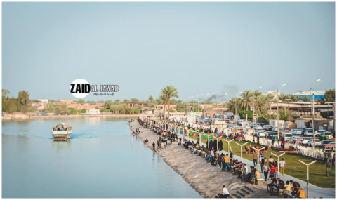
Key attractions on the site include the boat dock as shown in Figure 8(a), which acts as a landmark and a popular recreational location, particularly in the evening to avoid the hot midday temperatures. Wide green spaces running over the site as shown in Figure 8(b), and a pedestrian track utilized for athletic activities like walking and cycling. Another important feature is the Blue Arch Bridge as shown in Figure 8(c), which attracts many people due to its stunning river perspective and location for shooting great images. In addition, there are sales booths as in Figure 8(d).
(a) Boat dock
(b) Blue Arch Bridge
(c) Sidewalk, seats and green
(d) Sales booths and human gathering
Figure 8. Live on-site photos
2nd Scenario
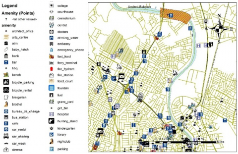
Key activities and functions in the site's surrounds were identified through field observation of adjacent areas and roads leading to and from the site, as well as the use of GIS. Commercial shops, restaurants, amusement parks, car dealerships, gas stations, nurseries, hotels, swimming pools, hospitals, public buildings, universities, and other establishments fall under this category…etc. All these are shown in Figure 9.
Figure 9. Detailed map showing different activities, GIS
Diversity is seen as one of the most important characteristics in attracting people to public areas and enhancing their vibrancy. However, during the site inspection, it was discovered that both internal and external activities are dispersed randomly, with a concentration in the research area. This has resulted in congestion in one tiny area while other parts remain underutilized. In some circumstances, families decide to avoid these activities in order to enjoy the peace and quiet of the riverbanks.
2.4.5 Traffic movement
Field studies revealed considerable traffic flow in the research area, particularly during evenings, holidays, and peak hours. This is inconsistent with the nature of the nearby streets, which have a pavement width of 10 meters for two-way traffic, resulting in traffic congestion and flow paralysis within the site. Driving behavior is often calm and sluggish due to the crowding and pedestrian movement in the region, as demonstrated in Figure 10 and Figure 8(a).
Figure 10. Primary and secondary highways network of rapid movement in Hillah City, GIS and Health Ministry of Iraq reports
2.5 Riverfront Accessibility Index
The Riverside Accessibility Index (RAI) is a composite analytical tool designed to assess the convenience and sustainability of public access to riverside venues including promenades and Corniches. This index incorporates a set of temporal, spatial, and behavioral characteristics, based on the Weighted Indicators Framework that has been successful in analyzing urban mobility initiatives and land use planning [35-38].
The mathematical formula of the index is constructed based on field survey data and is expressed as follows:
$R A I=F_w \cdot w 1+T_m \cdot w 2+Q_R \cdot w 3+A_P \cdot w 4+O_B \cdot w 5+A_d \cdot w 6$ (1)
This equation aggregates five primary dimensions:
$F_W$ (Frequency of Weekly Visits): Reflects the actual usability and vibrancy of the riverfront space.
$T_M$ (Mode of Transportation): Indicates the access method (e.g., walking, private car, or public transport).
$Q_R$ (Road and Infrastructure Quality): Assesses the condition and adequacy of the physical access routes.
$T_t$ (Travel Time): Represents the time required to reach the riverfront (time-related impedance).
$O_B$ (Reported Barriers): Captures the perceived or actual obstacles hindering access (e.g., physical, social, or safety-related).
$A_d$ (Activity Diversity): Variety of services, kiosks, entertainment.
The index provides a quantitative knowledge of riverfront public space accessibility and serves as a foundation for evidence-based urban planning policies that promote fairness, inclusion, and sustainable urban growth. The range of RAI values is between (0% and 100%). The optimum is 100% and the worst is 0%. For evaluation purposes, Table 2 is issued to evaluate the current accessibility to Hillah’s Corniche.
Table 2. Accessibility evaluation limitations [35, 39]
|
AI |
Accessibility |
|
< 50% |
Poor |
|
50-70% |
Moderate |
|
> 70% |
Good |
2.6 Variables normalization
Normalization is the process of transforming several forms of data (e.g., time in minutes, ratings out of 5, percentages, etc.) into a standard scale, often ranging from 0 to 1. This allows for the mathematical combination of variables with different units in a single composite index, such as the Accessibility Index (AI). Without normalization, adding variables like "travel time in minutes" to "road quality rated out of 5" wouldn’t make mathematical or conceptual sense [40]. The normalization equation may be as:
Accessibility variable $=\frac{\text { Actual value }- \text { Minimum value }}{\text { Maximum value }- \text { Minimum value }}$ (2)
2.7 Proposed weights priorities
Table 3 constitutes the previous accessibility variables with their proposed weights.
Table 3. Calculated accessibility variables and proposed weights
|
Variable |
Value |
Weights |
Value |
|
$F_W$ |
0.528 |
W1 |
0.2 |
|
$T_M$ |
0.757 |
W2 |
0.15 |
|
$Q_R$ |
0.528 |
W3 |
0.15 |
|
$A_P$ |
0.563 |
W4 |
0.2 |
|
$O_B$ |
0.571 |
W5 |
0.15 |
|
$A_d$ |
0.600 |
W6 |
0.15 |
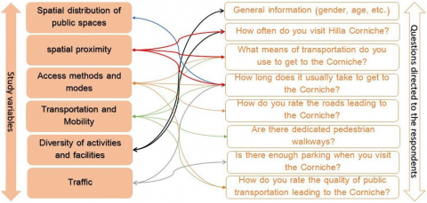
More than seventy people who frequent the place on a regular basis filled out the questionnaire. Several essential questions were presented to assess the site's accessibility, and the relationship between each question and the study variables was defined, as illustrated in Figure 11.
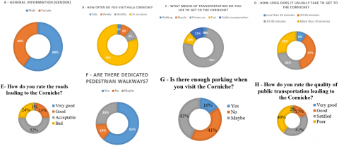
Both genders of varied ages were polled to get their thoughts on the site of Al-Hillah Corniche, specifically the research area. Of the 70 participants, 40% were men and 60% were women, as shown in Figure 12A.
Figure 11. Questionnaire and the extent of their coverage of the study variables
Figure 12. Graphical presentation of population questionnaire
In general, the location is visited at varied frequencies. Daily visits totaled 3%, weekly visits 8%, and monthly visits 9%. However, holidays and special occasions accounted for the majority of trips (80%). This shows that the facility (Al-Hillah Corniche) serves as a public space on a city-wide scale, yet access to it may not be readily available to everybody. As a result, it becomes more active around holidays and important occasions. These events include religious ceremonies performed by the river, as well as annual festivities and other comparable events, as shown in Figure 12B.
The questionnaire indicated a variety of methods for accessing the website. Walking accounted for 3% of residents living near the place, while public transportation was used by 11% and provided only indirect access to the site. Taxi transportation accounted for 10% of total travel, with private automobiles accounting for the highest share. This frequently helps to alleviate severe traffic congestion, as noted during the site documentation, where private transportation was primarily used as indicated in Figure 12C. The time required to reach the place varies based on the distance from various locations. Approximately 9% of respondents said they arrived within 10 minutes, 37% between 10 and 20 minutes, 26% within 20-30 minutes, and 28% took longer than 30 minutes. These findings indicate that access to the facility is constrained, implying a lack of efficient transportation flow. Al-Hillah Corniche is located in the city center, close to the Hillah River. In general, Al-Hillah's road network is crowded during peak hours, particularly within the 5.5-6.5 kilometer city zone as illustrated in Figure 12D. According to the questionnaire, the roads leading to the site were evaluated as follows: 1% evaluated them as excellent, 23% as good, 52% as satisfactory, and 24% as poor. These results do not accurately reflect reality or meet international road design standards. The roadways are inadequate for the city's population size, as even the broadest ones cannot carry more than three cars side by side as shown in Figure 12E. The presence of designated pedestrian paths was reported by 61% of respondents, while 13% indicated the absence of such paths, and 26% were unsure. These results suggest that pedestrian pathways do exist within the site itself, as previously mentioned. However, the external roads leading to the site lack dedicated pedestrian walkways, which leads to greater reliance on private transportation, contributing to traffic congestion, pollution, and an increased risk of accidents as presented in Figure 12F. In terms of parking availability, just 16% of respondents affirmed that there were enough places, 41% responded no, and 43% were unsure. This represents a clear lack of parking, which we noticed on our field visit. There is no designated or structured parking lot. The riverside area consists of a dirt embankment with fluctuating width and depth that is currently unsuitable for parking. Furthermore, commercial investment buildings occupy portions of this site, and various informal street vendor stalls can be seen throughout. These conditions limit vehicle access and parking, causing inconvenience for tourists. As a result, many people have difficulty finding sufficient parking and may be forced to shift their location to other public spaces that offer simpler access and better parking circumstances, as shown in Figure 12G. The quality of public transportation leading to the site was scored as 2% very good, 17% good, 41% satisfactory and 41% bad. As a result, we conclude that public transportation is either unavailable or only available on the site's periphery, as previously stated, requiring people to walk. This highlights a weakness in one of the potential recreational options for city dwellers who don't own private modes of transportation as in Figure 12H.
3.1 Key obstacles hindering access to the Corniche
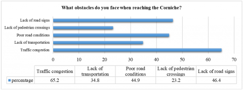
Regarding the most prominent obstacles identified in accessing the Corniche, 65.2% of respondents stated that there was traffic congestion, while 34.8% identified a lack of transportation options, 44.9% pointed to poor road conditions, 23.2% mentioned the absence of pedestrian walkways, and 46.4% noted the lack of directional signage as shown in Figure 13.
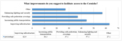
As for the improvements suggested by the respondents, 62.9% proposed enhancing the infrastructure, 44.3% recommended activating and increasing public transportation, 37.1% suggested providing safe pedestrian walkways, 57.1% proposed improving lighting and security, and 27.1% suggested other solutions. This is shown in Figure 14.
Figure 13. Challenges facing accessibility to the Corniche area
Figure 14. Respondents’ recommendations for improving access and safety at the Corniche
As a result, the overall AI to the riverside environment is at 61.3%, indicating fairly lower level of accessibility with identifiable impediments that require targeted intervention. The Rick Hansen Foundation Accessibility Certification (RHFAC) Guide defines standardized accreditation levels for evaluating accessibility and inclusiveness in buildings and public sites [41, 42]. According to the 2024 Guide (pp. 16 and 19), a certified rating is granted when a site achieves $\geq$ 60% of the total composite score, while a gold rating is awarded for achieving $\geq$ 80%. The system is based on a comprehensive point-based model that covers the forgoing accessibility variables. These standardized levels serve as quantitative benchmarks that can be used for comparison with composite accessibility indices for cities or public spaces.
Furthermore, the average park accessibility in major U.S. cities, according to the Trust for Public Land report (2025, p. 2), is 76% of residents live within a 10-minute walk of a public park, which is slightly higher than the current study's finding. In comparison, a European survey of 978 cities discovered that only 35% of residents exceed the accessibility criteria of 300 m to a green space [43, 44], demonstrating that Hillah Corniche outperforms the European average and is comparable to mid-sized metropolitan regions. In contrast, the Hillah Corniche result represents a moderate-to-good accessibility level, similar to moderately advanced urban environments, and highlights the need for further integration of transport and functional links to attain high-access locations (> 75%).
Based on the findings, the hypothesis was confirmed: "The level of activity in a public space is determined by the ease of access, which is in turn influenced by road patterns and modes of transportation." The liveliness and occupancy of any location (public space) are heavily reliant on how quickly it can be reached from all sections of the city in the lowest amount of time. As previously stated, this is directly related to the layout and quality of primary and secondary roads, as well as the availability of appropriate infrastructure—such as the separation of pedestrian and vehicular movement, the provision of green belts and shaded areas to protect and encourage pedestrian movement, particularly in spaces near public areas. Furthermore, designing an effective transportation network that fully connects city neighborhoods to public areas is critical to allowing individuals of all socioeconomic backgrounds to reach the site with little time, effort, and money. Furthermore, clear traffic signage, ample parking spaces, and a variety of transportation alternatives (both public and private) help to encourage repeat visits throughout the day, week, and month.
Therefore, ease of access to public spaces and achieving the highest possible levels of occupancy and vitality can be realized through the development of a flexible road network and a diversity of public and private transportation options, in addition to the availability of parking spaces. As for public spaces as points of attraction, they should offer a variety of activities and events, maintain a high level of safety and privacy, and provide a healthy environment that ensures the well-being of their users.
When comparing the two riverbanks, it is clear that the northern bank lacks many crucial aspects seen on the southern bank, including access routes, activities and events, parking areas, and spatial proximity. However, the northern bank's sense of privacy and tranquility has appealed to many families. As a result, it is critical to maintain diversity in the forms and characteristics of public areas.
1. The overall AI of the riverside environment of 58.5% may be increased to more than 60% by enhancing the accessibility variables of the riverine sides.
2. The equitable spatial distribution of riverside public spaces along the river, particularly within the study area, has improved accessibility to the site.
3. The Hillah Corniche's proximity to the city center has improved urban activity, resulting in more vibrancy and occupancy of the space.
4. The lack of public transportation to the Hillah Corniche has resulted in increased traffic congestion, lengthier travel times, and limited access for some social groups.
5. The inefficiency of access roads has hampered smooth traffic flow to the Hillah Corniche, limiting the ability to reach the location swiftly.
6. Private car ownership has improved mobility and gives users more flexibility in selecting appropriate times and routes to attend the site.
7. Variety of activities inside and around the Corniche has offered diverse options for visitors, establishing it as a major attraction that meets varying needs.
8. Unorganized parking areas have disrupted accessibility, reducing the desire to visit the site and increasing reliance on public transport at the periphery.
9. Enhanced security and privacy on the northern bank of the Hillah Corniche has encouraged visitation and increased occupancy.
10. Single-lane streets adjacent to the Corniche have led to significant traffic congestion during peak hours.
11. Lack of traffic signals on access roads to the site has caused confusion and delays, negatively impacting travel time to the Corniche.
1. Ensure that public areas are distributed evenly across the city in relation to population densities to minimize clustering or scattering, which limits access for diverse social groups.
2. Locate public spaces close or within residential areas to make them more accessible by foot or with little use of transportation, saving time, effort, and money.
3. Enhance and activate public transit systems to improve access and alleviate traffic congestion caused by an overreliance on private vehicles.
4. Create and enlarge roads going to public spaces, with at least two lanes to improve traffic flow and access.
5. Increase the number of activities and events available in public spaces to provide people with more options, hence encouraging longer and more frequent visits.
6. Create short and direct paths to public locations to increase accessibility and save travel time.
7. Provide appropriate and well-organized parking spots near public spaces to prevent haphazard roadside parking and guarantee smooth traffic flow.
8. Maintain a high level of safety and privacy in public areas that are consistent with local cultural values and traditions, in order to generate a sense of belonging and stimulate use—thus improving their vitality.
[1] Project for Public Spaces. (2000). How to Turn a Place Around: A Handbook for Creating Successful Public Spaces. SPP.
[2] McNeill, D. (2011). Fine grain, global city: Jan Gehl, public space and commercial culture in central Sydney. Journal of Urban Design, 16(2): 161-178. https://doi.org/10.1080/13574809.2011.548977
[3] Carmona, M. (2014). Re-theorising contemporary public space: A new narrative and a new normative. Journal of Urbanism: International Research on Placemaking and Urban Sustainability, 8(4): 373-405. https://doi.org/10.1080/17549175.2014.909518
[4] Gözlükaya, H., Ertekin, G.D.O. (2025). A systematic review and comparative policy analysis of sharing cities and their urban governance. Challenges in Sustainability, 13(4): 587-608. https://doi.org/10.56578/cis130409
[5] Paköz, M.Z., Işik, M. (2022). Rethinking urban density, vitality and healthy environment in the post-pandemic city: The case of Istanbul. Cities, 124: 103598. https://doi.org/10.1016/j.cities.2022.103598
[6] Mouratidis, K. (2017). Is compact city livable? The impact of compact versus sprawled neighbourhoods on neighbourhood satisfaction. Urban Studies, 55(11): 2408-2430. https://doi.org/10.1177/0042098017729109
[7] Elmqvist, T., Andersson, E., Frantzeskaki, N., McPhearson, T., Olsson, P., Gaffney, O., Takeuchi, K., Folke, C. (2019). Sustainability and resilience for transformation in the urban century. Nature Sustainability, 2(4): 267-273. https://doi.org/10.1038/s41893-019-0250-1
[8] Holy-Hasted, W., Burchell, B. (2022). Does public space have to be green to improve well-being? An analysis of public space across Greater London and its association to subjective well-being. Cities, 125: 103569. https://doi.org/10.1016/j.cities.2022.103569
[9] Tonnelat, S. (2010). The sociology of urban public spaces. In Territorial Evolution and Planning Solution: Experiences from China and France, Paris, pp. 84-92.
[10] Raimbault, M., Dubois, D. (2005). Urban soundscapes: Experiences and knowledge. Cities, 22(5): 339-350. https://doi.org/10.1016/j.cities.2005.05.003
[11] Yu, Y., Huang, G., Sun, D., Lyu, M., Bart, D. (2025). Exploring the impact of waterfront street environments on human perception. Buildings, 15(10): 1678. https://doi.org/10.3390/buildings15101678
[12] Attia, S., Ibrahim, A.A.A.M. (2017). Accessible and inclusive public space: The regeneration of waterfront in informal areas. Urban Research & Practice, 11(4): 314-337. https://doi.org/10.1080/17535069.2017.1340509
[13] Bertolini, L. (1999). Spatial development patterns and public transport: The application of an analytical model in the Netherlands. Planning Practice and Research, 14(2): 199-210. https://doi.org/10.1080/02697459915724
[14] Wendt, M. (2009). The importance of death and life of great American cities (1961) by Jane Jacobs to the profession of urban planning. New Visions for Public Affairs, 1: 1-24.
[15] Whyte, A.V. (2000). Assessing Community Telecentres: Guidelines for Researchers. IDRC.
[16] Erkip, F.B. (1997). The distribution of urban public services: The case of parks and recreational services in Ankara. Cities, 14(6): 353-361. https://doi.org/10.1016/s0264-2751(97)00026-7
[17] Che, Y., Yang, K., Chen, T., Xu, Q. (2012). Assessing a riverfront rehabilitation project using the comprehensive index of public accessibility. Ecological Engineering, 40: 80-87. https://doi.org/10.1016/j.ecoleng.2011.12.008
[18] Vian, F.D., Izquierdo, J.J.P., Martínez, M.S. (2021). River-city recreational interaction: A classification of urban riverfront parks and walks. Urban Forestry & Urban Greening, 59: 127042. https://doi.org/10.1016/j.ufug.2021.127042
[19] Talen, E. (2000). Measuring the public realm: A preliminary assessment of the link between public space and sense of community. Journal of Architectural and Planning Research, 17(4): 344-360.
[20] Lau, J.C.Y., Chiu, C.C.H. (2003). Accessibility of low-income workers in Hong Kong. Cities, 20(3): 197-204. https://doi.org/10.1016/s0264-2751(03)00013-1
[21] Abdulla, K.M.A.B., Abdelmonem, M.G., Selim, G. (2017). Walkability in historic urban spaces: Testing the safety and security in martyrs' square in Tripoli. International Journal of Architectural Research: ArchNet-IJAR, 11(3): 163. https://doi.org/10.26687/archnet-ijar.v11i3.1378
[22] Al-Khafaji, A.S., Al-Salam, N.A., Alrobaee, T.R. (2021). The cognition role to understanding planning and architectural production. Civil Engineering Journal, 7(7): 1125-1135. https://doi.org/10.28991/cej-2021-03091715
[23] Gupta, A., Yadav, M., Nayak, B.K. (2025). A systematic literature review on inclusive public open spaces: Accessibility standards and universal design principles. Urban Science, 9(6): 181. https://doi.org/10.3390/urbansci9060181
[24] Calthorpe, P. (1993). The Next American Metropolis (Vol. 23). Princeton Architectural Press.
[25] Coombes, E., Jones, A.P., Hillsdon, M. (2010). The relationship of physical activity and overweight to objectively measured green space accessibility and use. Social Science & Medicine, 70(6): 816-822. https://doi.org/10.1016/j.socscimed.2009.11.020
[26] Sugiyama, T., Cerin, E., Owen, N., Oyeyemi, A.L., et al. (2014). Perceived neighbourhood environmental attributes associated with adults recreational walking: IPEN Adult study in 12 countries. Health & Place, 28: 22-30. https://doi.org/10.1016/j.healthplace.2014.03.003
[27] Harnik, P. (2006). The excellent city park system: What makes it great and how to get there. In The Human Metropolis: People and Nature in the 21st-Century City, pp. 47-60.
[28] Li, Z., Fan, Z., Song, Y., Chai, Y. (2021). Assessing equity in park accessibility using a travel behavior-based G2SFCA method in Nanjing, China. Journal of Transport Geography, 96: 103179. https://doi.org/10.1016/j.jtrangeo.2021.103179
[29] Logan, T.M., Williams, T.G., Nisbet, A.J., Liberman, K.D., Zuo, C.T., Guikema, S.D. (2017). Evaluating urban accessibility: Leveraging open-source data and analytics to overcome existing limitations. Environment and Planning B: Urban Analytics and City Science, 46(5): 897-913. https://doi.org/10.1177/2399808317736528
[30] Zhang, R., Cao, L., Wang, L., Wang, L., Wang, J., Xu, N., Luo, J. (2024). Assessing the relationship between urban park spatial features and physical activity levels in residents: A spatial analysis utilizing drone remote sensing. Ecological Indicators, 166: 112520. https://doi.org/10.1016/j.ecolind.2024.112520
[31] Ali, A.R., Hussein, A.A., Abood, K.F., Al Maimuri, N.M.L. (2023). Sensitivity of infiltration models in rural soils overlying unsteady shallow groundwater. The Iraqi Geological Journal, 56(1D): 43-57. https://doi.org/10.46717/igj.56.1d.4ms-2023-4-13
[32] Ali, A.R., Jabbar, D.N., Abood, K.F., Al Maimuri, N.M.L. (2021). Water phase inclination theory for hydraulic conductivity determination of vadose zones in shallow water table systems. The Iraqi Geological Journal, 54(2B): 85-100. https://doi.org/10.46717/igj.54.2b.8ms-2021-08-28
[33] Al Maimuri, N.M.L., Al Sa’adi, Hassan, A.H.M., Ali, A.R., Al Mamouri, Z.N.M., Albadry, A.M. (2024). Sustainable infrastructure reframing and development for crowded cities to facing future epidemic disasters beyond Covid-19 in Hillah city, mid-Iraq. AIP Conference Proceedings, 3092: 020007. https://doi.org/10.1063/5.0199800
[34] Maimuri, N., Al-Asedi, T.M., AL-Anssari, N., Al-Fatlawi, M., Al Mamouri, Z.N.M., Rashid, F.L., Mohammed, O.I., Al-Khazraji, A.A., Mohammed, S. (2025). Sustainable prediction of epidemic spread and building up urban health: A case study of Hillah, Iraq, using Weka for intelligent city development. AIS - Architecture Image Studies, 6(1): 8-25. https://doi.org/10.48619/AIS.V6I1.1083
[35] Geurs, K.T., van ee, B. (2004). Accessibility evaluation of land-use and transport strategies: Review and research directions. Journal of Transport Geography, 12(2): 127-140. https://doi.org/10.1016/j.jtrangeo.2003.10.005
[36] Tu, W. (2015). Quantitative methods and socio-economic applications in GIS. The AAG Review of Books, 3(3): 135-137. https://doi.org/10.1080/2325548x.2015.1050769
[37] Sepe, M. (2013). Urban history and cultural resources in urban regeneration: A case of creative waterfront renewal. Planning Perspectives, 28(4): 595-613. https://doi.org/10.1080/02665433.2013.774539
[38] Papa, E., Bertolini, L. (2015). Accessibility and transit-oriented development in European metropolitan areas. Journal of Transport Geography, 47: 70-83. https://doi.org/10.1016/j.jtrangeo.2015.07.003
[39] Silva, C., Pinho, P. (2010). The structural accessibility layer (SAL): Revealing how urban structure constrains travel choice. Environment and Planning A: Economy and Space, 42(11): 2735-2752. https://doi.org/10.1068/a42477
[40] OECD, European Union, & Joint Research Centre - European Commission. (2008). Handbook on constructing composite indicators: Methodology and user guide. OECD. https://doi.org/10.1787/9789264043466-en
[41] Rick Hansen Foundation. (2024). RHFAC Guide to Certification (version 4.2). November 2024. Page 3: “Certified” = 60% minimum; “Gold” = 80% minimum. https://pub-saskatoon.escribemeetings.com/filestream.ashx?DocumentId=73537.
[42] Pratt Tremblay, M. (2024). Architecture without barriers: Creating thoughtful connections within the built environment. Master's theses, Laurentian University.
[43] Barboza, E.P., Cirach, M., Khomenko, S., Iungman, T., et al. (2021). Green space and mortality in European cities: A health impact assessment study. The Lancet Planetary Health, 5(10): e718-e730. https://doi.org/10.1016/S2542-5196(21)00229-1
[44] Barboza, M.H.C., Carneiro, M.S., Falavigna, C., Luz, G., Orrico, R. (2021). Balancing time: Using a new accessibility measure in Rio de Janeiro. Journal of Transport Geography, 90: 102924. https://doi.org/10.1016/j.jtrangeo.2020.102924