Rana Mazin Mahdi*![]() | Wazeen Wafeeq Nasser
| Wazeen Wafeeq Nasser![]()
© 2025 The authors. This article is published by IIETA and is licensed under the CC BY 4.0 license (http://creativecommons.org/licenses/by/4.0/).
OPEN ACCESS
The concepts of fragmentation and dispersion are among the most important concepts in analyzing the urban fabric of residential neighborhoods, due to their direct impact on shaping the spatial and social structure, especially in neighborhoods and cities that have witnessed rapid growth and economic and political transformations that have led to the unbalanced reproduction of residential space. This research is based on a set of recent visions and studies that consider carefully studied fragmentation to be an effective tool for regulating urban growth and achieving functional integration between its components by stitching the fabric in specific parts to restore it. This research explores the mechanisms of fragmentation and residential dispersion in residential neighborhoods. Fragmentation refers to the spatial distribution of residential areas as separate units isolated from each other and not connected functionally or spatially. At the same time, dispersion represents an advanced stage of urban disintegration. It focuses on how to patch, reconnect, and connect the city's separate neighborhoods to restore the urban and social fabric and reshape the urban and societal cohesion that was damaged by this fragmentation. The research aims to formulate a theoretical framework based on stitching and reconnecting disjointed or isolated neighborhoods and residential areas and apply it to the research sample, while exploring the characteristics of these connecting components capable of restoring harmony and integration to the urban fabric at various levels, such as roads, services, and social life. The research relied on morphological analysis using ArcView software to study the relationship between subdivision and fragmentation by analyzing the network of main axes of the residential project and its relationship to the surrounding neighborhoods and the center, with a focus on indicators of urban connectivity, spatial integration, and levels of urban control. The results demonstrated the potential for transforming these two phenomena into development tools when managed consciously, as urban control and spatial integration criteria play a pivotal role in shaping the residential environment while maintaining a balance between population density and environmental requirements. The study concluded that the mechanism of fragmentation and stitching can be transformed into a sustainable means of urban development by adopting a thoughtful urban and architectural design that takes into account spatial specificity based on criteria of connectivity, integration, control, privacy, and clarity. Intelligent functional division that maintains the interconnectedness of residential units. Effective communication networks that connect the fragmented parts.
housing fragmentation, stitching, residential dispersion, urban sprawl, ArcView, housing development, restore fabric
Urban and social fragmentation is one of the most prominent features of urban life and, consequently, one of the most important research topics in urban studies. Based on a legacy dating back to the Chicago School of the early twentieth century, social segregation is viewed as a natural consequence of the social division of space. The phenomenon of urban fragmentation and dispersion has emerged as a pivotal concept in the context of contemporary urban development, requiring a deep understanding and thoughtful management to achieve a balance between urban development requirements and social and environmental sustainability. This phenomenon has transformed from an urban challenge into an integrated strategy that can be employed to improve the quality of residential environments and restore the fabric of fragmented residential neighborhoods. The novelty of this research lies in its consideration of carefully planned and deliberate fragmentation and stitching processes as an effective tool for regulating urban growth and achieving functional integration. The current study focuses on an old and a new residential area, examining them in terms of fragmentation criteria. Therefore, the research gap lies in the lack of clarity regarding the role of fragmentation and stitching as development mechanisms capable of improving the quality of residential neighborhoods towards achieving urban and social development. A comprehensive assessment of the area itself and its neighbors is then presented using ArcView. Urban indicators that achieve development based on fragmentation measures (connectivity, integration, control, privacy, and sense of place) were also studied at the level of each segment of the project, and at the level of its relationship with the surrounding areas and the city center. The results indicated a relative degree of integration and connectivity between the project and its surrounding areas, and greater control over the project's main axes compared to the main axes connecting it to the city center, providing greater privacy. The old residential neighborhood achieved higher rates than the new neighborhood in terms of activities, lifestyles, and architectural styles, and at the project level compared to the city. The study emphasized the need to create urban integration between fragmentation and housing, which ensures the sustainability of residential projects over time and increases residential stability. The remaining parts of the research were organized as follows: Section 2 relied on a review of previous literature that addressed the main research themes and formulated the theoretical framework after exploring fragmentation indicators, criteria, and the factors influencing them. In Section 3, the study area was defined and analyzed, and the network of urban fabric axes was studied at the residential project level, at the project level, and at its distance from the city center. As for Sections 4-6, the research presented a comprehensive evaluation of fragmentation and stitching through their development as modern and sustainable development mechanisms, with a discussion of the results of the analysis of the research sample.
2.1 Definition and concepts
2.1.1 Residential dispersion and fragmentation
In Arabic, fragmentation is breaking or tearing into small parts. Fragmentation is defined as: "A state in which something is split into parts that may be equal or scattered in random or uncontrolled ways" [1]. In English, the word "dispersion" means "scattering" or "broken." We can say that an urban residential environment is fragmented due to the dispersion and fragmentation within its parts that occur to the person walking through it [2]. Residential fragmentation refers to the distribution of residential areas in patches or blocks separated from each other by undeveloped land, such as agricultural or natural lands [3]. Its characteristics include:
•Residential areas are separated but functionally connected to the city.
•It often occurs as a result of inadequate urban planning or the expansion of residential areas toward the suburbs.
•It may result in techniques such as the creation of green spaces or highways separating residential communities.
It has the following effects:
•Positive: Creating open spaces between areas Residential development may improve the quality of life.
•Negative: It leads to higher infrastructure costs and increased reliance on personal transportation.
The concept of fragmentation is linked to retail through distribution, spread, and density.
•Residential dispersion: It refers to the uneven distribution of residential areas away from the urban core, such that these areas are far from each other and from central areas.
•Residential fragmentation: It refers to the distribution of residential areas in the form of separate patches or blocks that are not directly connected to each other, with non-residential areas (such as agricultural or natural lands) separating them.
It is clear from the above that the positive effects of fragmentation are represented by the creation of open spaces between neighborhoods, thus improving residential development quality of life, a principle adopted by this research. The negative effects lead to increased infrastructure costs and increased reliance on personal transportation.
Some cities begin residential fragmentation by creating small housing units separated by open spaces. Over time, fragmentation develops as urban growth expands more widely and randomly outside the urban center. Residential fragmentation can increase when scattered development projects are established far from the infrastructure, leading to greater dispersion if urban sprawl is not controlled or interconnections are not developed [4].
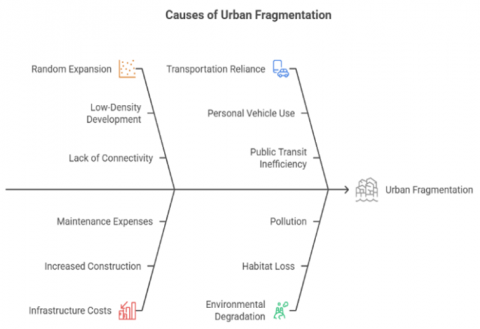
From the above, fragmentation in the urban environment can be defined as the irregular and discontinuous expansion of residential or urban areas away from the city center. This pattern arises as a result of random horizontal expansion outside the traditional city boundaries, characterized by low population density and a lack of integration between areas. The above can be summarized in the following Figure 1.
Figure 1. Cause of fragmentation
2.1.2 Fragmentation and its relationship to patterns of urban housing development
•Fragmentation as a catalyst for urban sprawl
Urban fragmentation refers to the disjointed spread of urban areas on the outskirts of cities, resulting in a phenomenon of haphazard sprawl, also known as "fragmented urbanism." This pattern often occurs in cities that lack integrated urban planning, where residential and service areas grow haphazardly and are disconnected from each other. This phenomenon leads to environmentally and economically unsustainable urban patterns, increasing residents' dependence on private transportation, which in turn increases pollution and energy consumption. It also depletes natural resources due to urban sprawl encroaching on agricultural land and green spaces. Economically, fragmented sprawl increases the costs of providing municipal services and infrastructure due to the spread of built-up areas over vast areas [5].
Urban segregation, based on the residential separation of different groups within cities, represents a form of lack of social contact, even in mixed-use areas. The phenomenon of social distancing is explained by the lack of encounters and interactions in daily life [6].
Mutual tolerance is generated by interaction between residents in divided residential environments [7]. Netto et al. [8] argue that residential neighborhoods that do not create meeting spaces promote coexistence between different groups. This situation can be considered a factor in spatial segregation. The main reason behind this fragmentation is the lack of spatial structures capable of achieving social interaction in open spaces [9].
Urban encounters in the interstitial spaces within socially and spatially divided residential environments enable interaction between different groups that can experience temporary co-presence in public space, which Watson [10] considers a site of potential, difference, and enjoyable encounters. Netto [9] considers co-presence a bodily experience through which actors within the spatial boundaries of a social situation perceive that others have been sharing the space [11].
•Fragmentation as a stage of urban growth
In some cases, urban fragmentation can be considered a transitional stage in urban growth, especially in the early stages of urban expansion. Before infrastructure development and the integration of transportation and service networks, separate urban centers may emerge. These scattered areas can be transformed into integrated parts of the urban fabric. For example, some rapidly growing Asian cities, such as Shanghai and Bangkok, experienced phases of urban fragmentation before being integrated through efficient mass transit systems and integrated service systems. This is where proactive urban vision comes in, transforming fragmentation from a problem into an opportunity for balanced growth [8]. Urban growth has a direct impact on urban development patterns. It can either promote or hinder development, depending on the nature of its management. Fragmentation can be transformed into a tool to relieve pressure on the urban center. For example, the establishment of new, fully serviced cities on the outskirts of major cities can provide an alternative to unplanned sprawl, provided these cities are well connected to the main urban centers. Some European cities, such as Copenhagen and Barcelona, have succeeded in developing a “compact city” model that limits uncontrolled urban sprawl, while providing diverse housing options [10].
•The relationship between fragmentation and urban development
Urban growth has a direct impact on urban development patterns, as it can either enhance or hinder development depending on the nature of its management. For example, establishing new, fully serviced cities on the outskirts of major cities can provide an alternative to unplanned sprawl, provided these cities are well connected to the main urban centers. Some European cities, such as Copenhagen and Barcelona, have successfully developed a "compact city" model that limits unplanned sprawl while providing diverse housing options [12].
2.1.3 The complementary relationship between fragmentation and dispersion in urban development
1- Fragmentation as a Mechanism for Regulating Urban Fragmentation: Urban development represents a dynamic system in which urban fragmentation patterns interact with urban fragmentation strategies. Fragmentation, when managed consciously, transforms from a mere physical division of spaces into an effective planning tool. This relationship becomes clear when:
•Functional fragmentation transforms spatial fragmentation into integrated urban units.
•Residential fragmentation transforms from a negative phenomenon into a well-thought-out population distribution strategy.
•Real estate zoning patterns become part of a comprehensive development policy [13].
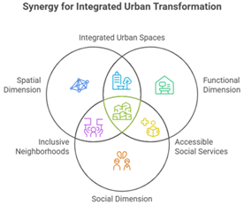
2- Mechanisms for Transforming Negative to Positive Fragmentation: This process requires three dimensions:
A. The spatial dimension:
•Transforming fragmented areas into fully serviced "urban cells".
•Applying the principle of smart fragmentation through adjacent but functionally independent residential units.
B. The functional dimension:
•Homogeneously distributing service centers within fragmented areas.
•Connecting fragmented units to flexible transportation networks (the Hub-and-Spoke model).
C. Social dimension:
•Transforming residential fragmentation into an opportunity to create balanced population diversity [14].
•Investing in family divisions to build micro-communities. Figure 2 illustrates the stages of urban transformation within the concepts of fragmentation and disintegration, followed by Table 1, a comparison between the two concepts.
Figure 2. Transforming fragmentation
Table 1. Comparison between the concept of fragmentation and dispersion within the standards
|
Standard |
Disprtion |
Planned Fragmentation |
|
Density |
irregular |
graded by location |
|
Services |
centralized |
distributed hierarchically |
|
Transport |
individual/random |
integrated/hierarchical |
|
Sustainability |
low |
high |
Reshaping residential neighborhoods and activating spatial and social connections within the broader urban fabric. Fragmentation is not a factor of fragmentation, but rather a tool for reorganizing urban spaces in an integrated manner that contributes to mending the fragmented urban fabric. This is achieved by integrating effective connecting elements such as paths, public spaces, and multifunctional activities, enhancing urban harmony and addressing aspects of isolation and marginalization. This research seeks to explore the potential of components of the urban fabric capable of achieving reconciliation between residential neighborhoods and to identify their most important features and characteristics. This will be examined in the following paragraph.
2.1.4 Stitching fragmented neighborhoods
Sevik and Caliskan's [15] study argued that mending fragmented neighborhoods aims to restore the residential fabric and ensure a sense of belonging by connecting neighborhoods with vibrant and creative shared spaces. This is achieved through designs that provide a safe and healthy environment for all and ensure active interactions between community members, while ensuring a sustainable and effective environmental balance. The careful design of interconnected public spaces between neighborhoods, complementing networks and connections, involves stitching them into the fragmented urban fabric, giving neighborhoods a distinct, interconnected character and making them more complete [15].
Tonkiss [11] demonstrated that neighborhoods contain boundary spaces that function as porous and resistant cellular membranes. When these boundaries are broken down, the boundary becomes visible and active. Active boundaries as highways, railway lines, and park edges, which not only divide space but also create new spaces as interstitial areas open to new possibilities. These marginal, invisible spaces, despite their importance in spatial interactions, are not as perceived as designed public spaces. These spaces reduce spatial social distances, bring neighborhoods closer together, and transform heterogeneous neighborhoods into homogeneous ones by increasing encounters between residents and blurring boundaries, rather than physical isolation between different communities. Social communication can be generated within these ill-defined border areas if the conditions for coexistence and encounters are met [16].
Social fragmentation plays a fundamental role in creating the tensions prevalent among residents of neighborhoods living in divided residential areas. One of the most important considerations in designing these interstitial spaces is that they are connected by street networks and pedestrian paths, ensuring the integrity of the overall fabric of the area. The intersection of people's daily routes in the spatial network of the neighborhood fabric creates a diversity and density of commonly used commercial functions spread across the site, enabling the emergence of different thresholds as meeting places and coexistence [17]. Netto [9] argued that increasing the complexity of social networks in interstitial spaces reduces the negative effects of spatial segregation. The location of food and beverage outlets, medical services, and bus stops enhances the overlap of networks and the possibility of meeting. Urban attractions such as bus stations and shopping centers play a role in coexistence and convergence among residents. The synchronicity and potential separation in the density of encounters along the routes help determine temporal alignments in movement patterns between different social actors. Nearby residents meet during the day at certain times, meeting and spending a significant amount of time in nearby locations. Spatial segregation can also be observed where higher-income residents live and commute closer to the central business district. The residential locations of low-income actors vary relative to the central business district, but their usual activity locations tend to be concentrated within 3 kilometers of the central point. The lack of synchronization resulting from spatial differences is somewhat offset by the influence of the urban center on shared proximity. Line densification refers to the proximity patterns of streets located at a similar distance from the central business district, demonstrating the influence of location on potential contact between different social groups. Szabó [18] also demonstrated that the development of infrastructure and transportation networks is a key factor in bridging fragmented neighborhoods through efficient transportation networks, including:
•Establishing rapid public transportation systems (metro/dedicated buses).
•Developing smart infrastructure (roads equipped with traffic sensors).
•Connecting the outskirts of cities to urban centers via major axes [18].
•Identifying model urban areas (urban growth boundaries).
•Adopting green building standards (energy efficiency, use of sustainable materials).
•Protecting agricultural land through strict legislation.
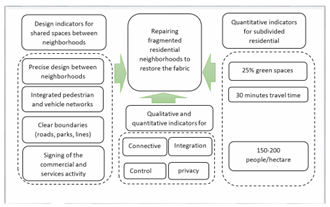
The proposals also identified the most important indicators used to construct a positive fragmentation model, based on quantitative indicators. These include a percentage of green spaces of no less than 25%, an optimal population density (150-200 people/hectare), and a travel time of less than 30 minutes to reach service centers. Qualitative indicators included the level of integration, connectivity, privacy, and control (which will be addressed in the research), the quality of shared services, and the flexibility of urban design [19].
Regarding the characteristics of the connecting areas for patchwork fabric, which depend on the composition of street networks, others argue for the importance of medium-scale spatial characteristics, such as the porosity of urban blocks and the diversity of building types. Still others focus on the characteristics of small-scale spaces that enhance interaction and communication between groups (Figure 3) [20].
Figure 3. Research flowchart
2.1.5 Residential fragmentation as a sustainable development strategy
Recent urban studies indicate that the fragmentation of residential neighborhoods can be transformed from a negative phenomenon into an effective development strategy by applying an integrated set of design standards. This vision is based on four main axes aimed at achieving a balance between urban development and quality of life [21].
Sustainable residential distribution is the cornerstone of this strategy, requiring precise land zoning standards, including setting a minimum residential area of no less than 500 square meters per unit, according to the recommendations of the United Nations Human Settlements Programme. This thoughtful distribution ensures the provision of sufficient green spaces and appropriate infrastructure, while preventing excessive zoning in densely populated areas, which leads to overcrowding and deterioration of services.
Functional integration between urban fabric components enhances the effectiveness of residential zoning by allocating mixed-use areas that combine residential units, employment centers, and daily services. This model, adopted by many global cities such as Copenhagen and Barcelona, reduces the need for long commutes and enhances community cohesion. It also supports vertical residential development by encouraging the construction of multi-story residential complexes instead of horizontal units, which conserves land and increases its efficient use [22].
The second axis focuses on developing integrated neighborhoods that provide a fully serviced residential environment. This is evident in the design of residential complexes that incorporate educational, healthcare, and recreational facilities within the neighborhood's urban fabric, while providing an efficient internal transportation network that includes pedestrian and bicycle paths. The principle of density gradation should also be applied, which proposes a balanced distribution of population density according to the neighborhood's location, with high densities concentrated near service and commercial centers [23].
Ownership and management policies are essential to the success of the housing subdivision strategy. These policies require establishing clear systems for managing shared property, encouraging the formation of owners' associations, and clearly defining maintenance responsibilities. They also include the development of affordable housing programs that provide small, subsidized housing units for low-income families, while implementing innovative systems such as "development rights" that allow for density transfers between different areas [24].
Combating informal settlements is at the core of this strategy. This requires strengthening urban control mechanisms through the use of geographic information systems to monitor urban changes and requiring building permits to comply with urban sustainability standards. This strategy also includes ambitious programs to rehabilitate informal settlements and transform them into urban development areas with integrated services and facilities. These four axes add new standards to enhance the quality of residential zoning, most notably the integration and connectivity standard, which ensures that residential units are connected to transportation networks and services; the control standard, which regulates real estate zoning processes; and the privacy standard, which preserves the social and cultural characteristics of local communities. Together, these standards form an integrated framework that transforms residential zoning from an urban challenge into an opportunity for sustainable development. This is what we will address in the following paragraphs, where we focus on the criteria for positive zoning within the study area [25].
2.2 Theoretical framework
By analyzing several studies related to the research scope, we identified indicators specific to the concept of fragmentation and ways to address it, making it a positive strategy in the housing context, taking into account that these indicators are measurable as follows:
Criteria such as integration, connectivity, continuity, and control play a pivotal role in understanding and analyzing the phenomenon of housing fragmentation and its impact on urban and social development. These criteria are primarily used in urban planning to assess the efficiency of the distribution of housing, infrastructure, and services, and their impact on quality of life.
1- The concept of fragmentation and its relationship to these criteria
Housing fragmentation refers to the heterogeneous distribution of housing and facilities, leading to gaps in the urban fabric, whether spatial (building spacing) or social (gaps between social classes).
•Poor integration and connectivity lead to increased fragmentation.
•Lack of continuity in the urban fabric reinforces urban isolation.
•Poor control over land use and services creates unstable and incoherent environments [19].
2- Integration criterion
a) Definition
It refers to the extent to which different parts of a city or neighborhood are connected, whether at the physical level (streets and infrastructure) or at the functional level (distribution of activities and services).
b) Types of integration
•Spatial integration: The extent to which residential spaces are connected to public facilities and urban networks.
•Social integration: The ability of residents from different backgrounds to interact and participate in community life.
•Economic integration: The extent to which neighborhoods are interconnected in terms of the flow of goods, services, and employment opportunities.
c) Relationship with fragmentation
Strong integration reduces fragmentation by strengthening the links between different neighborhoods.
Lack of integration leads to the emergence of isolated communities and disconnected areas, further weakening social and economic cohesion.
3-Connectivity criterion
a) Definition
Connectivity refers to the ease with which people and goods move between different parts of a city or neighborhood. This includes road networks, walkways, transportation, and digital communications.
b) Types of connectivity
•Spatial connectivity: Focuses on transportation infrastructure.
•Digital connectivity: The importance of the internet and communications in connecting modern societies.
•Social connectivity: The ability of residents to easily access vital services and facilities [26].
c) Relationship with fragmentation
Strong connectivity = Low fragmentation: The greater the ease of access, the smaller the gaps between residential areas.
Weak connectivity = Increased fragmentation: Poor transportation infrastructure reinforces urban isolation and limits development opportunities.
4-Continuity criterion
a) Definition
Continuity refers to the degree of harmony and connection between the components of the urban environment, such that individuals experience a smooth transition between different spaces without sharp interruptions.
b) Types of continuity
•Urban continuity: Maintaining a unified or homogeneous urban pattern in design and appearance.
•Functional continuity: Integrating various activities such as housing, work, and recreation within the same urban environment.
•Environmental continuity: Connecting green spaces and open areas in a way that supports environmental sustainability [27].
c) Relationship with fragmentation
Strong continuity reduces fragmentation because it creates a homogeneous environment that supports smooth mobility and social interaction.
Weak continuity increases fragmentation by creating spatial discontinuities such as natural barriers or abandoned areas.
5- Control criterion
a) Definition
Control refers to the ability of residents or local authorities to effectively manage and direct the use of urban spaces. This includes control over design, land use, and the regulation of social activities.
b) Types of control
•Urban control: Managing the distribution of land, buildings, and infrastructure.
•Social control: The ability of society to control activities that influence social behavior, such as security and order.
•Economic control: Directing economic development to ensure the equitable distribution of resources and services.
c) Relationship with fragmentation
Effective control = Reducing fragmentation: Urban policies and planning help manage urban growth sustainably.
Lack of control = Increasing fragmentation: Weak urban planning leads to the spread of informal settlements and exacerbates social and economic gaps.
-Privacy: This indicator is measured by combining the terms integration and control at the part level.
-Clarity and attractiveness of place: This indicator is measured by combining the terms integration and connectivity.
-Sense of place: This indicator is measured by combining the terms clarity and privacy [27].
3.1 Method of analysis and practical study
This part of the research explains a comprehensive assessment of fragmentation and a study of the interconnected impact of fragmentation criteria within a residential area in Basra, southern Iraq. This is done through a spatial configurational analysis of the movement axes using the analysis program (ARCVEIW), which was used by urban designers and researchers to reveal the morphological formation of the movement axes by measuring the comprehensive morphological indicators on which the program relies (connectivity, integration, control, and privacy).
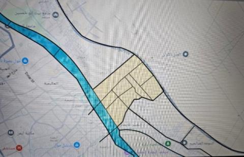
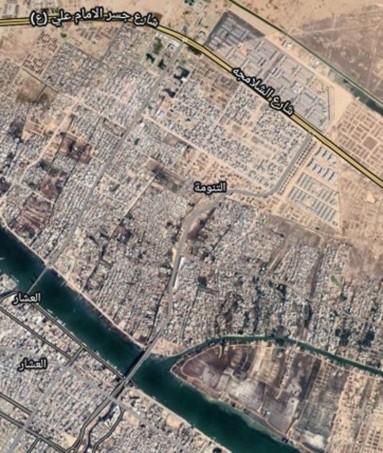
3.1.1 Selected sample: Al-Tanuma City in Basra, southern Iraq
(1) Location of Basra City
Basra is located in the far south of Iraq on the western bank of the Shatt Al-Arab, a waterway formed by the confluence of the Tigris and Euphrates rivers at Al-Qurna, 110 km north of the city of Al-Faw. Basra City is approximately 55 km from the Arabian Gulf and 545 km from Baghdad. It shares international borders with the Kingdom of Saudi Arabia and Kuwait to the south, and the Islamic Republic of Iran to the east. Basra Governorate shares its local borders with the governorates of Dhi Qar and Maysan to the north, and with the governorate of Muthanna to the west. Basra is Iraq's only port and its main sea outlet (Figure 4) [28].
Figure 4. The location of Basra City relative to the Arabian Gulf and Iraq
Basra is the third-largest city in Iraq, characterized by a rapidly increasing population, coupled with a severe housing shortage. As a result, the unplanned and random sprawl of housing is increasing to accommodate population growth. One of these cities, Tanuma, was chosen as the research sample.
(2) Tanuma City in Basra
The Tanuma area in Basra is a vital area that has witnessed significant transformations in its urban and architectural structure over the decades. In the past, Tanuma was characterized by cohesive residential communities, with neighborhoods close together, a cohesive community, and vast agricultural areas, especially palm groves that surrounded residential areas. In addition, it is located near the Iranian-Iraqi border and is close to the Shalamcheh border crossing [29].
Over time, and as a result of economic and social developments, the area began to experience a degree of housing fragmentation. This was manifested in:
•Unregulated urban expansion: the increase in random construction without prior planning This led to the division of agricultural lands and their conversion into residential areas, affecting the traditional urban fabric.
•Migration and population growth: The increase in population, whether through natural growth or migration from other areas, placed pressure on infrastructure and led to the creation of new neighborhoods, some of which lacked adequate planning [30].
•Economic changes: Some residential areas were transformed into commercial or industrial areas as a result of economic development, leading to changes in land use and fragmentation of residential areas.
•Environmental impacts: Some agricultural areas deteriorated due to neglect or pollution, forcing residents to relocate and build new homes in other areas, leading to further fragmentation.
Currently, relevant authorities are seeking to address these challenges by developing urban plans aimed at reorganizing land use, improving infrastructure, and preserving remaining green spaces to ensure sustainable development that restores the urban and social cohesion of Tanmia [31].
(3) The network of axes that fabricate the city of Tanuma with its surroundings and the main city center
A. In the past (Old Tanuma)
•Cohesive urban fabric:
Tanuma was characterized by interconnected residential neighborhoods and narrow streets linking homes, mosques, and traditional markets.
Most of the population relied on agriculture, creating a balance between residential and agricultural uses.
•Limited but effective infrastructure:
Public facilities were easily accessible, and there were no isolated areas or areas unconnected to the rest of the city.
•Homogeneous communities:
The traditional social character contributed to reducing fragmentation, as residents lived within close-knit communities with strong economic and social ties.
b. Present day (Modern Tanuma)
•Emergence of isolated areas:
- Due to uncontrolled expansion, residential areas are now poorly connected to the road and transportation network, creating areas isolated from the rest of the city.
- The construction of gated residential complexes has increased, increasing the level of segregation between different areas.
•Weak transportation networks and infrastructure:
Despite the development of the road and bridge network connecting Tanuma to the center of Basra, some areas still suffer from poor connectivity, leading to increased fragmentation.
•Conversion of agricultural land into urban areas:
- This transformation has led to the loss of open spaces and increased unplanned sprawl, creating a heterogeneous urban environment.
•Disparities in the level of services:
- Some areas enjoy advanced services, while others suffer from a lack of basic facilities such as schools and health centers, leading to disparities in living standards.
In terms of structure, streets are the most stable element. They provide easy and quick access, and are more resistant to crises over time. The study area is characterized by its regular, functional network and a clear hierarchy based on urban importance. It contains primary and secondary roads. This can be clear in Figure 5.
Figure 5. The network of axes and their connection to the mother city
Source: Researchers based on satellite images and Basra Municipality plans
In general, we notice that the main axis network tends to be organic and some of it is geometric, and as a result of the winding topography of the land, the axes were run as a result of their winding. And because of the area’s proximity to the Shalamcheh border crossing with the Iranian border, the area expanded with residential complexes on the outskirts of Tanuma, bypassing the agricultural areas and green spaces. As for the axis network towards the mother city, it is characterized by winding and sloping due to its proximity to the rivers and its parallelism to them. The required plan, research, graphs and satellite diagrams were collected. After analyzing the case study, exploring the indicators and analyzing the site within the spatial analysis program according to the required criteria, the research reached a set of results, which we will discuss in the next paragraph.
4.1 ArcView synthetic analysis indicators
We used the Synthetic Analysis program to analyze the study area, its neighborhoods, and the parent city (we chose the main and secondary axes) of the region due to the large number of axes in the region and the difficulty of the program accommodating a large number of them. This, in turn, affects the program's readable ratios. By measuring the axes network, the most important findings of the analysis can be explained as follows.:
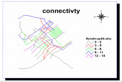
Connectivity: By analyzing the network of axes of the study area with the neighboring areas and with the city center, it was found that the project’s connectivity with the mother city is via two bridges: the Italian Bridge and the Martyr Kanaan Bridge. The Italian Bridge has reduced congestion since its construction and helped in connectivity with the mother city. The ratio via the bridge ranged between 10-5, which is one of the highest ratios in the project, while the low connectivity ratios in the project’s parts ranged between 0-5, due to the fragmentation and division in parts of the city of Tanuma at large rates. As for the residential complex located within the area, which is the Narcissus project, the connectivity ratios were average, ranging between 6-8, while in the parts of the project (Narcissus), the fragmentation ratios are low due to the organization of the design and the organization of the site with the neighboring areas. The hierarchy can be explained by the fact that connectivity is less the further you are from the city center, except for the Italian Bridge area. The highest values were reached near the Narjis residential project, which is located near the study area. and the general connectivity of investors over the area, as shown in Figure 6.
Figure 6. Connectivity indicator
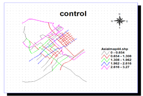
- Control: The analysis results showed that the structural control of the project's axes was weak due to fragmentation and unorganized distribution. The highest control rate was near the Khalid Bridge area, an agricultural area characterized by an organic texture, and the control rate was 3.27. As for the modern residential areas in the region, their axes were characterized by poor control due to the boring and repetitive geometric distribution, and ranged between 0.0 and 1.3. Near the first and second Narjis cities towards the Shalamcheh border crossing. As for the remaining parts of the project, the control rates were relatively weak due to fragmentation, fragmentation, the absence of distribution and planning, and the general control of investors over the area, as shown in Figure 7.
Figure 7. Control indictor
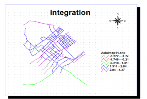
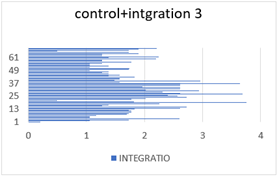
Figure 8. Integration indictor
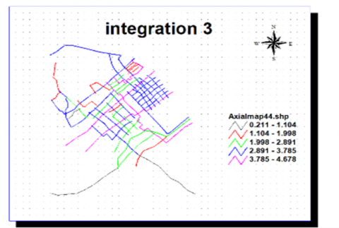
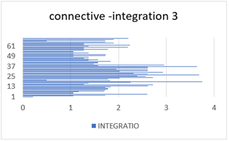
Figure 9. Integration 3 indict
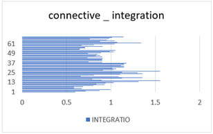
Integration: At the city level and at the level of project parts with the neighborhoods: The analysis results showed that the project’s integration with the city (integration) was weaker than it is with the integration of project parts (integration 3) with each other and with the neighborhoods. The highest integration value for the project parts with each other and with the neighborhoods from the residential areas and from the expansion areas of the residential complexes towards the Shalamcheh outlet was 4.6, which is the highest percentage in the project. The integration values with the city center occupied a lower amount, as it was 4.3, as shown in Figure 8 and Figure 9. The main reason for the low degree of integration with the city is due to the direction of the Tanuma area is being fragmented by residents and the population is growing at an uncontrolled rate. Most families are forced to live in small areas, encroaching on agricultural areas. Residential land is being fragmented into smaller sections by investors to exploit the largest possible amount of land within the area. This is in addition to the lack of planning, oversight, and government regulations in the region. Using the ArcVeiw program, we were able to obtain the above data. Secondary criteria, such as privacy, sensation, and clarity, can be obtained by combining two specific criteria from the program and obtaining an overall average. Due to the program's complexity and its connection to Google Maps, we were unable to obtain direct percentages from the program. Researchers were forced to link the program to Microsoft Excel to arrive at the percentages for the above criteria. The results were as follows:
Privacy: It can be reached by integrating the values of control and integration 3. The percentages of privacy were different, as in the old Tanuma areas, privacy was higher than in the modern residential areas, where it reached 0.73 due to the organic streets and the spread of Agricultural land and lack of renovation. The privacy ratio in the newly developed areas was lower, at 0.49. This indicates little privacy for a multi-axis subdivision and large populations within a small residential area. This is achieved by the project. The following Figure 10 illustrates the privacy ratio.
Figure 10. The nature of the relationship between the control and integration at the level of project components
Clarity: This indicator was measured by combining the connectivity and integration indicators in two ways. Clarity became apparent immediately after the construction of the Italian Bridge. Due to its height and orientation, the bridge increased the clarity ratio in the area in the front part and in the future expansion areas.
Figure 11. The nature of the relationship between the connectivity and integration indicators to achieve clarity at the city level
The clarity ratio reached its highest level, at 0.89, in the areas near the Italian Bridge, while it reached 0.83. The relationship can be illustrated in Figures 11 and 12.
Figure 12. The nature of the relationship between the connectivity and integration indicators 3 to achieve clarity at the level of project components
The percentage of measuring the clarity index at the level of project components was the result of combining the connectivity and integration indicators 3, and the percentage was 0.9, which is the highest percentage in the program. This indicates the high clarity between the project components, as shown in Chart 3. Sense of Place: This is achieved by calculating the ratio of the clarity and privacy indicators across project components. The ratio was 0.8 in the old residential areas, while in the new areas, the sense of place ratio was lower, 0.5, which is a good ratio compared to the highest ratio measured by the program, 0.9. This indicates a sense of place resulting from achieving privacy and clarity for the project at varying levels. Based on the above results, the structural analysis revealed a set of factors that led to fragmentation and, prior to fragmentation, to disintegration. These factors included a lack of control, weak integration across most parts of the project, and a lack of connectivity between the project, its components, its neighbors, and even the city center. Finally, the researcher summarized the set of results between the old and new city according to the segmentation criteria in the following Table 2.
Table 2. Comparison between the old and new city
|
Standard |
Old Area |
Modern Area |
|
Urban Fabric |
Cohesive and interconnected with narrow streets and clear relationships between homes and facilities |
Fragmented and heterogeneous, with isolated areas |
|
Uses |
Balance between housing and agriculture |
Convert agricultural lands into residential and urban areas |
|
Connectively |
Good within the local fabric (5-10) |
Weak between segments (0-5) with improvement at the major axes |
|
Integration |
High internally (4.6) |
Low with space (4.3) |
|
Control |
Organic and spontaneous (3.27) |
Weak and organized (0-1.3) |
|
Privacy |
High (0.73) due to organic fabric |
Low (0.49) due to density |
|
Clarity |
Medium (0.83) |
High at the axes (0.89) |
|
Sense of Place |
Strong (0.8) |
Weak (0.5) |
|
Infrastructure |
Limited but effective |
Development but unbalanced |
|
Social Cohesion |
High with homogeneous communities |
Low with separate communities |
|
Service Distribution |
balanced |
Unequal and unfair |
|
Street Style |
Organic and curvy |
Geometric and partially organized |
|
Population Density |
Medium and balanced |
High and irregular |
Table notes:
1. -The old area shows a better balance in most criteria, despite its primitiveness.
2. -The modern area suffers from a disintegration of the urban and social fabric.
3. -Main axes (such as the Italian Bridge) have brought about a relative improvement in connectivity.
4. -The loss of privacy and social cohesion in the modern area, despite urban development.
5. -The differences indicate the importance of preserving traditional urban values during development.
4.2 The research proposes
In Basra, specifically in the Al-Tanuma area, the proposal to establish an interactive transitional zone between the old district and the newer areas emerges as an urban response aimed at achieving spatial and social integration. The concept is based on allocating an urban space that serves as a mediator linking the architectural and cultural heritage of the old city with the modern architectural and service-oriented character of the new developments. This is achieved through a design that blends elements of the traditional environment with contemporary urban treatments. The zone aims to enhance social interaction among residents of different generations and backgrounds by creating public spaces, pedestrian pathways, traditional markets, and cultural and recreational areas. As a result, it becomes a vibrant urban bridge that helps narrow the gap between the past and the present (Figure 13).
Figure 13. The locations proposed by researchers to serve as stitching points within the residential fabric between old and new areas
5.1 Conclusions
The issue of fragmentation in residential areas is considered one of the most significant risks facing modern, even advanced, contemporary cities, due to the fragmentation of residential buildings, streets, green areas, and open spaces. As a result of the lack of planning, design, and supporting laws, the problem has intensified and evolved from its initial stages of residential collapse, fragmentation, and division to its most dangerous stage: fragmentation. Despite the seriousness of these factors, a group of studies has attempted to find formulas and standards to turn them into positive attraction factors, to accommodate the greatest possible number of services, controlling housing migration, and achieving justice through a set of laws and regulations led by a group of engineers and architectural designers to limit individual neglect. A set of conclusions can be made regarding the theoretical aspect, followed by conclusions regarding the practical aspect.
I. Theoretical conclusion
II. Practical conclusion
5.2 Recommendation
Addressing urban fragmentation requires a hybrid planning model combining:
This approach transforms fragmentation from a threat into an opportunity for achieving balanced, sustainable development.
5.3 Research word and advice
Segmentation is a planning strategy that redefines urban division from a negative phenomenon to a development tool, through:
Transforming fragmented units into integrated bio-urban modules, achieving urban balance between density and services, and applying the principle of "Controlled Dispersal," designed by Japanese architect Kenzo Tange. "Segmentation is not a problem, but an opportunity to reshape urban DNA." Architect Zaha Hadid at the United Nations Urban Development Conference (2012). "When segmentation becomes a planning language, we must carefully write its grammar rules." Urban planner Christopher Alexander in his book "Pattern Language" (1977). "The best cities are those that can transform their fragmentation into a functional mosaic."
Architecture is the grasp of truth-Louis Kahn. The reality of the current environmental reality is uncontrolled fragmentation, and stakeholders must address this reality positively to support the laws of nature and the residential environment, in collaboration with architectural designers. Those who look to the laws of nature to support their new work collaborate with the creative-Cody. Improving the reality of cities is the responsibility of their people. The lines of old cities are positive effects that we must preserve and develop to build the new environment through their integration with what came before it. We must build architecture on the environment-Toyo Ito.
[1] CABE. (2005). What home buyers want: Attitudes and decision making among consumers. Commission for Architecture and the Built Environment.
[2] Business Dictionary. (2012). Business Dictionary. Retrieved, December 26, 2012.
[3] Sung, H., Lee, S., Cheon, S. (2015). Operationalizing jane Jacobs’s urban design theory: Empirical verification from the great city of Seoul, Korea. Journal of Planning Education and Research, 35(2): 117-130. https://doi.org/10.1177/0739456X14568021
[4] UN-Habitat. (2013). A New Strategy of Sustainable Neighbourhood Planning: Five principles - Urban Planning Discussion Note 3. https://mirror.unhabitat.org/pmss/getElectronicVersion.aspx?nr=3518&alt=1.
[5] Rudaini, T., Mahdi, R. (2025). Proposed treatment strategies for aging residential complexes: Zayouna Residential Complex in Baghdad as a case study. Iraqi Journal of Architecture and Planning, 24(1): 59-73. https://doi.org/10.36041/iqjap.2025.155755.1122
[6] Mohammed, N., Mazin, R. (2025). Strategies for urban densification in the city of Baghdad-Kadhimiya, A case study. AIP Conference Proceedings, 3169(1): 040076. https://doi.org/10.1063/5.0256421
[7] Freeman, L.C. (1978). Segregation in social networks. Sociological Methods & Research, 6(4): 411-429. https://doi.org/10.1177/004912417800600401
[8] Netto, V.M., Paschoalino, R., Pinheiro, M. (2010). Social networks in the city, or the urban condition of coexistence. Virus, 4(1): 1-11. http://www.nomads.usp.br/virus/virus04/?sec=4&item=5&lang=en.
[9] Netto, V.M. (2017). The social fabric of cities: A tripartite approach to cities as systems of interaction. Area Development and Policy, 2(2): 130-153. https://doi.org/10.1080/23792949.2017.1315540
[10] Watson, S. (2006). City Publics: The (Dis)Enchantments of Urban Encounters. Routledge. https://doi.org/10.4324/9780203962954
[11] Tonkiss, F. (2005). Space, the city and social theory: Social relations and urban forms. Polity Press. https://doi.org/10.1111/j.1468-4446.2007.00162_18.x
[12] Rudaini, T.H., Mahdi, R.M. (2025). Activation of sustainable urban mobility in aging residential complexes: "Zayouna Residential Neighborhood in Baghdad" as a case study. International Journal of Sustainable Development and Planning, 20(2): 875-882. https://doi.org/10.18280/ijsdp.200235
[13] Wijesundara, J., Wijekoon, N. (2017). Transitory urban interventions for effective place making in shopping streets: Case of Pettah in Sri Lanka. Cities People Places: An International Journal on Urban Environments, 2(1): 10-25. https://doi.org/10.4038/cpp.v2i1.16
[14] Mohammed, N., Mazin, R. (2025). Enhancing sensitive urban densification through infill development: A GIS analysis of vitality and integration in Jawaher Dijla residential compound, Iraq. AIP Conference Proceedings, 3169(1): 040068. https://doi.org/10.1063/5.0256153
[15] Sevik, E., Caliskan, O. (2022). Coexistence in space: Stimulating encounter in the socially fragmented open urban fabrics. Built Environment, 48(3): 364-392. https://doi.org/10.2148/benv.48.3.364
[16] Fincher, R. (2003). Planning for cities of diversity, difference, and encounter. Australian Planner, 40(1): 55-58. https://doi.org/10.1080/07293682.2003.9995252
[17] Paschoalino, R., Soares, M., Netto, V. (2015). Segregated networks in the city. International Journal of Urban and Regional Research, 39(6): 1084-1102. https://doi.org/10.1111/1468-2427.12346
[18] Szabó, M. (2018). The regional development of democratization and civil society: Transition, consolidation, hybridization, globalization - Taiwan and Hungary. Przegląd Politologiczny, (4): 153-172. https://doi.org/10.14746/pp.2018.23.4.11
[19] Hall, C.M., Ram, Y. (2018). Walk Score® and its potential contribution to the study of active transport and walkability: A critical and systematic review. Transportation Research Part D: Transport and Environment, 61: 310-324. https://doi.org/10.1016/j.trd.2017.12.018
[20] Journal of the American Institute of Planners. (1976). Royal Australian Planning Institute Journal, 14(1-2): 20. https://doi.org/10.1080/00049999.1976.9656483
[21] Nasser, W.W., Mahdi, R.M. (2023). The role of connectivity and integration in cultivating attractive values: A space syntax study of Al-Amal housing project, Basra. International Journal of Sustainable Development and Planning, 18(9): 2847-2859. https://doi.org/10.18280/ijsdp.180923
[22] Khalaf, M., Rasheed, K., Mahdi, R. (2022). Formal activation through complexity characteristic. Iraqi Journal of Architecture and Planning, 21(2): 76-94. https://doi.org/10.36041/iqjap.2022.133311.1036
[23] King, J., Perry, C. (2017). Smart buildings: Using smart technology to save energy in existing buildings. ACEEE American Council for an Energy-Efficient Economy. https://www.aceee.org/sites/default/files/pdfs/a1701.pdf.
[24] Riaz, M., Munir, S., Asghar, Z. (2014). On the performance evaluation of different measures of association. Revista Colombiana de Estadística, 37(1): 1-24. https://doi.org/10.15446/rce.v37n1.44353
[25] Chen, Z., Li, X. (2021). Unobserved heterogeneity in transportation equity analysis: Evidence from a bike-sharing system in southern Tampa. Journal of Transport Geography, 91: 102956. https://doi.org/10.1016/j.jtrangeo.2021.102956
[26] Mahdi, R.M., Aboud, A.H. (2021). Underground housing formation strategies. Journal of Physics: Conference Series, 1773(1): 012033. https://doi.org/10.1088/1742-6596/1773/1/012033
[27] Khalaf, M.A., Rasheed, K.G., Mahdi, R.M. (2023). Strategy of active housing. AIP Conference Proceedings, 2651(1): 020061. https://doi.org/10.1063/5.0105803
[28] Mahdi, R.M., Al-Kaissi, K.A. (2020). Active housing design that supports health. IOP Conference Series: Materials Science and Engineering, 870(1): 012009. https://doi.org/10.1088/1757-899X/870/1/012009
[29] Leitner, H. (2011). Spaces of encounters: Immigration, race, class, and the politics of belonging in small-town America. Annals of the Association of American Geographers, 102(4): 828-846. https://doi.org/10.1080/00045608.2011.601204
[30] Huang, B.X., Chiou, S.C., Li, W.Y. (2020). Accessibility and street network characteristics of urban public facility spaces: Equity research on parks in Fuzhou City based on GIS and space syntax model. Sustainability, 12(9): 3618. https://doi.org/10.3390/su12093618
[31] Nasser, W.W., Mahdi, R.M. (2025). Intervention strategies for developing sustainable housing values: A descriptive analysis of impact and mechanisms. AIP Conference Proceedings, 3169(1): 040039. https://doi.org/10.1063/5.0254290