Mutiawati Mandaka*![]() | Wiendu Nuryanti
| Wiendu Nuryanti![]() | Dyah Titisari Widyastuti
| Dyah Titisari Widyastuti![]()
© 2025 The authors. This article is published by IIETA and is licensed under the CC BY 4.0 license (http://creativecommons.org/licenses/by/4.0/).
OPEN ACCESS
Lasem, a historic city in Central Java, Indonesia, possesses a unique urban morphology shaped by its rich cultural heritage and historical development. The city's distinctive layout and architectural elements reflect influences from Chinese, Javanese, and colonial traditions. Understanding how Lasem's urban morphology contributes to tourism potential is essential for sustainable heritage preservation and economic growth. This study employs a qualitative approach, combining field observations, spatial analysis, and interviews with local stakeholders. Historical documentation and urban morphology analysis are used to examine the city's structural patterns, heritage zones, and tourism dynamics. Lasem's unique urban morphology demonstrates significant tourism potential throughout its development periods. Findings indicate that the city's urban morphology across seven historical layers forms three classifications of tourism potential: existing tourism potential, developing tourism potential, and ideal tourism potential. These tourism potentials are derived from physical urban morphological elements, the distribution of physical elements, historical urban components, historical city patterns, and tourism targets (attractions, amenities, and accessibility).
historical tourist town, Lasem, coastal, potential tourism, urban morphology
Lasem is a historic city on the north coast of Central Java that is unique in its urban morphology. As a city with a long history of trade and cultural interaction, the layout and building patterns in Lasem reflect influences from Chinese, Javanese and colonial cultures. Studies on the morphology of historic cities show that the physical form of the city that develops from social, economic and cultural factors plays an important role in increasing tourist attractiveness [1]. Understanding urban structure can enhance a city's appeal to both residents and tourists [2]. This concept is considered relevant to Lasem, where the unique urban planning pattern and historic architectural heritage are regarded as key factors in the development of cultural tourism. It has been revealed that Lasem’s urban morphology has undergone significant transformations due to tourism growth, leading to changes in spatial patterns and land use [3].
Research has shown that the evolution of China's historic cities (HCTs) towards tourism-oriented spaces has led to the concentration of tourism-focused functions in the city center, while cultural relics remain more freely distributed [4]. Waterfront developments in cities such as Melaka and Makassar have highlighted the importance of balancing tourism-driven change with the preservation of local identity, often resulting in conflicts between commercial viability and community needs [5]. Moreover, the transformation of historic cities such as Bijapur during different phases of development underscores the importance of nodality and landmarks in creating sustainable built forms [6]. Analyzing the spatial correlation between the tourist hotel industry and urban morphology in Phoenix Ancient City, China, has revealed evolving characteristics and impacts on spatial morphology over time, emphasizing the need for comprehensive territorial spatial planning [7]. Resort morphology, especially in developing countries such as those in Asia, remains an understudied area that requires a systematic approach considering the contextual factors that influence the morphological character of these destinations [8].
Over time, the morphological evolution of Lasem has significantly contributed to the emergence of growing tourism potential. However, existing literature has yet to specifically examine how changes in urban morphology give rise to such potential. Lasem serves as a representative case of a small city where this phenomenon is evident. Accordingly, this study addresses the research question: What forms of tourism potential have emerged as a result of morphological changes in the city of Lasem?
The central hypothesis of this research posits that transformations in Lasem’s urban morphology—driven by socio-economic and cultural dynamics—have generated new spatial configurations that foster cultural tourism development. These include the formation of heritage districts, thematic corridors, and historically significant public spaces, which have become increasingly integrated into the local tourism system.
The aims of this study are twofold: (1) to classify the types of tourism potential arising from changes in Lasem’s urban morphology, and (2) to develop recommendations for the management and conservation of the city’s morphological structure, with the goal of enhancing the tourist experience and promoting the preservation of Lasem’s cultural heritage.
Urban morphology, derived from the Greek words “morphe” (form) and “logy” (study), refers to the study of the formation, transformation, and structure of urban spaces, including their historical evolution and influencing factors [9]. This concept serves as a critical analytical framework in understanding how cities evolve, highlighting the socio-spatial processes that shape their built environments [10]. Understanding these morphological characteristics is essential in tracing a city’s developmental trajectory and planning for its future [11]. Initially, the study of morphology contributed cognitively by explaining urban form, and later expanded into a normative role by proposing how cities should be designed and developed [12, 13].
Urban morphology analyzes various components such as street networks, land use distribution, building typologies, and spatial configurations [14, 15]. Its interdisciplinary nature integrates natural sciences and the humanities, contributing to robust analytical methodologies that inform urban planning and design practices [16, 17]. Comparative studies of cities across regions, including Europe and Asia, further reveal how cultural, historical, and socio-economic contexts influence morphological development [18]. Examples from cities such as Rome, London, Singapore, and Tokyo illustrate the interplay between architecture, street layouts, and changing land use patterns, which reflect the historical and cultural identity embedded within urban form [18]. These studies help in identifying the historical development of urban areas, enabling a deeper understanding of how past decisions influence the current urban form [18]. In the context of Lasem, a small historic city in Central Java, Indonesia, analyzing urban morphology provides insights into the tourism potential arising from its spatial and historical transformations.
The physical elements that shape urban morphology include road systems, land parcel arrangements, building patterns, and architectural styles [19-21]. These elements evolve alongside non-physical components such as socio-economic dynamics, cultural narratives, and political contexts [1], forming the holistic fabric of urban environments. Historical reviews are particularly important in heritage cities, where layered transformations reveal both continuities and disruptions in urban form [22, 23].
In heritage studies, the Tourist Historic City theory provides a useful lens for analyzing how historic urban cores function as tourism assets. It emphasizes four main dimensions: physical heritage (buildings, monuments, streets), symbolic heritage (cultural meanings and historical narratives), tourism functions (museums, visitor centers, heritage trails), and spatial adaptation (modern interventions to enhance tourism usability) [24]. This theory illustrates how cities can integrate preservation and tourism, ensuring cultural continuity while accommodating modern needs. Lasem’s heritage elements—ranging from Chinese-style shop houses and colonial buildings to symbolic narratives of trade and migration—offer a unique case to examine these interactions.
The formation of a historic city typically occurs in stages. Initially, the urban core functions as the focal point of activity. As the city expands, the original core retains its centrality, while new development surrounds it. In later phases, historic areas undergo re-evaluation, triggering preservation efforts and redefining their role within the broader urban context. Changes to the central business district (CBD), often overlapping with historic cores, reflect shifting economic functions, and lead to adaptive reuse and revitalization [22]. This evolutionary process is evident in Lasem, where historical layers coexist with emerging tourism functions, making it an ideal subject for urban morphological analysis.
The concept of tourism potential becomes increasingly relevant in this context. It refers to both tangible and intangible assets—such as architecture, street layouts, traditions, and communal life—that can be leveraged to attract visitors. An ideal tourism city balances growth with heritage conservation, community well-being, spatial quality, and accessibility. Understanding urban morphology is thus vital in recognizing how historical spatial forms support current and future tourism opportunities, especially in small heritage towns like Lasem.
Numerous international case studies reinforce the significance of urban morphology in supporting tourism development. In Bilbao, Spain, the strategic integration of historic architectural elements with iconic modern structures, such as the Guggenheim Museum, redefined place identity and transformed the city into a global cultural tourism hub [25]. Similarly, in Fez Medina, Morocco, the preservation and adaptive use of traditional urban morphology facilitated heritage-led regeneration and sustainable tourism [26].
In Asia, the town of Jinshitan, China, demonstrates how spatial intensification—including changes in building density, height, and land use—correlates with tourism-oriented infrastructure expansion from 1988 to 2019 [27]. A complementary study on Dalian Jinshitan National Holiday Resort shows a transition from fragmented to integrated landscape patterns, driven by inland development and spatial restructuring [28]. Meanwhile, research in Hoi An, Vietnam, highlights the role of urban morphology in balancing urban growth with cultural preservation, recommending mechanisms such as Transfer of Development Rights (TDR) to maintain equilibrium between conservation and development in coastal tourism [29].
These studies collectively demonstrate that transformations in urban morphology—whether organically evolved or strategically planned—have profound implications for tourism development. Preserving spatial identity and cultural landscapes not only maintains authenticity but also contributes to economic vitality. In Lasem, the evolving urban morphology offers a framework for identifying emerging tourism potentials, such as thematic corridors, heritage clusters, and historically significant public spaces. Drawing from international best practices, this research situates Lasem within broader discourses on heritage-led urban planning and proposes contextually grounded strategies for sustainable cultural tourism.
There are seven strategies used in architectural research [30], namely: (1) historical interpretive, (2) qualitative, (3) correlational, (4) experimental and quasi-experimental, (5) simulation and modeling, (6) logical argumentation, and (7) case study and combined strategies. In the case of Lasem, the historical interpretive strategy is adopted, as it is particularly suited for investigating past processes and events. Historical records and phenomena are used as comparative frameworks to trace the origins and influencing factors of urban spatial development. This approach emphasizes the connection between past and present conditions, enabling a more comprehensive understanding of the evolution of specific phenomena. It is especially relevant for research focusing on cultural heritage, spatial transformation, and socio-economic adaptation in historical contexts.
In this study, the historical interpretive strategy is applied to explore the evolution of Lasem as a center of trade and cultural exchange. The first step involves identifying the research problem, specifically focusing on aspects such as historical periodization and the influence of tourism on urban planning. Data collection involves accessing colonial archives, historical manuscripts, and physical evidence such as Chinese-style residential architecture, temples, and other heritage structures. Source criticism is conducted to assess the authenticity, credibility, and potential bias of archival materials as well as oral sources gathered from the local community.
In addition to literature and documentary research, field data were collected through direct observation in historic districts and primary urban corridors in Lasem that have undergone significant spatial changes. Field observations focused on identifying elements of urban morphology such as street patterns, plot configurations, building functions, and the transformation of public spaces. Visual documentation—including photographs, site sketches, and situational maps—was used to support the analysis. Semi-structured interviews were also conducted with community leaders, local tourism actors, and owners of heritage buildings to gather insights into social meanings, perceptions, and dynamics related to morphological changes and their impact on tourism.
The collected data were analyzed qualitatively using a thematic approach to identify relational patterns between urban morphological change and emerging tourism potential. Spatial analysis was also carried out by overlaying historical and contemporary maps to trace shifts in spatial structure and land use. These findings were interpreted within broader socio-economic and cultural contexts to understand how historical processes and contemporary dynamics have interacted to shape the current urban landscape of Lasem.
A narrative synthesis was then constructed to integrate all findings, explain the forms of tourism potential generated by urban morphological changes, and offer heritage-based recommendations for sustainable tourism development in Lasem.
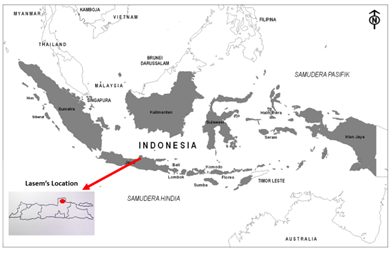
Indonesia, as an archipelagic nation, encompasses a diverse array of regions characterized by distinctive geographical and cultural features. One such region is Lasem, located in Rembang Regency, Central Java. Geographically, Lasem lies between 111°00'-111°30' East Longitude and 6°30'-7°00' North Latitude (Figure 1). Positioned in the eastern part of Rembang Regency, it is strategically situated along the northern coastal highway (Pantura), which enhances its regional connectivity and accessibility. The regency shares a direct boundary with East Java Province, while Lasem is located approximately 12 kilometers from the coastline of the Java Sea and the administrative center of Rembang Regency.
Lasem is bordered by the Java Sea to the north, Pancur Sub-district to the south, Sluke Sub-district to the east, and Rembang Sub-district to the west. Spanning a total area of 4,504 hectares, Lasem features a multifaceted land use structure. This includes approximately 505 hectares of residential zones that serve as focal points for community activity, 281 hectares of fish ponds that support the local aquaculture industry, and 624 hectares of state-managed forest areas that contribute to ecological balance and environmental sustainability. This diverse pattern of land utilization underscores the multifaceted role of Lasem in social, economic, and ecological dimensions.
As part of Rembang Regency, Lasem possesses distinctive characteristics that position it as a potential hub for tourism, particularly in the domains of cultural and coastal tourism. The city's morphological structure—shaped by centuries of trade and intercultural exchange—has given rise to a unique urban landscape marked by a concentration of historic buildings and traditional settlement configurations. These elements not only represent architectural heritage but also embody layers of cultural narratives and social practices.
With its advantageous geographic location, well-preserved historical environment, and dynamic socio-cultural fabric, Lasem holds considerable potential to be developed as a cultural tourism destination. The preservation of its historical morphology, coupled with strategic urban and tourism planning, can provide an authentic visitor experience that reinforces cultural identity while supporting sustainable local development.
Figure 1. Location of Lasem on the map of Indonesia
Lasem experienced a series of political and administrative transformations from the Majapahit era through to the Dutch colonial period and beyond. During the Majapahit period, governance began in 1351 under Bhre Lasem Dewi Indu Purnamawulan, followed by Prince Badrawardhana and his lineage. In 1470, Prince Wirabadra was appointed as Adipati (Duke) of Lasem and relocated the political center to Bonang Binangun. His successors, including Prince Badra Negara and Nyai Ageng Maloka, were instrumental in the development of strategic areas such as Caruban Beach and Puri Kawak, reflecting a localized urban expansion.
During the early Islamic period, leadership passed to Prince Tedjakusuma I, who played a vital role in the Islamization of Lasem by establishing the Lasem Mosque in 1588. The arrival of Islamic scholars, including Sayyid Abdurrahman Ba-Syaiban, further accelerated the region’s religious transformation and integration into broader Islamic networks in Java.
In the period of Chinese Muslim influence, Lasem came under the jurisdiction of the Islamic Mataram Kingdom. The line of Prince Tedjakusuma continued until Prince Tedjakusuma V, who was officially appointed as Adipati of Lasem by Sultan Pakubuwana I in 1714. Following this, Raden Panji Margono declined to assume leadership, and administrative control was transferred to the Syahbandar (Harbor Master) Oei Ing Kiat, later titled Tumenggung Widyaningrat. He governed from 1727 to 1745 and was notably involved in the Yellow War (also known as the Gada Walik War, 1740-1743), a localized resistance against the Dutch East India Company (VOC), which included religious leaders such as Mbah Baidlawi and the Laskar Santri militia.
During the Dutch colonial period, Lasem came under the rule of Suradadi Menggolo III and later Citrasoma, who administered the region from the Duchy of Binangun or Bonang. However, indigenous leadership structures gradually diminished under colonial centralization.
Under Japanese occupation (1942-1945), Lasem faced severe socio-economic disruptions. The imposition of the romusha (forced labor) system led to widespread exploitation of local populations for Japanese military infrastructure projects. This period was marked by deteriorating living conditions and limited access to resources. Nevertheless, the spirit of resistance endured, and several local figures from Lasem were involved in the broader Indonesian independence movement.
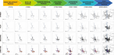
Following Indonesia’s proclamation of independence on August 17, 1945, Lasem was integrated into the newly formed Republic of Indonesia. The post-independence era witnessed administrative restructuring, aligning Lasem within Rembang Regency. This period also saw the introduction of national policies related to economic revitalization, educational development, and cultural tourism, laying the groundwork for Lasem’s role in regional development planning. Based on successive periods of leadership, a historical periodization can be identified, each corresponding to distinct transformations in the urban morphology of Lasem. These changes are evident in the evolution of street patterns, plot arrangements, building typologies, and land use, as illustrated in Figure 2 [3].
The morphological transformations of Lasem over time—analyzed through the components of paths, plots, buildings, and land use—demonstrate the spatial completeness and complexity of the city in each historical period. These components include transportation routes such as rivers, roads, and railway lines; land plots belonging to both Chinese and indigenous communities; and building typologies encompassing residential structures, mosques, temple complexes, Chinese temples, and burial sites. Land use elements consist of ports, markets, fishponds, salt ponds, dry lands, rice fields, settlements, administrative centers, and religious facilities (Figure 2).
Changes in Lasem’s urban morphology from the Majapahit period to the post-independence era reflect the dynamic interplay between leadership transitions and evolving governmental policies. During the Majapahit and early Islamic periods, the city exhibited a well-structured and relatively complete urban layout, suggesting early forms of planned settlement (Table 1). The Chinese Muslim period marked the peak of spatial development, characterized by the expansion of urban functions to support trade, cultural exchange, and the growth of a multi-ethnic society.
In the Dutch and Japanese colonial periods, the city’s spatial structure remained largely intact, although land use became increasingly oriented toward administrative, military, and exploitative functions. Following Indonesian independence in 1945, Lasem underwent structural adjustments in governance, yet these changes had limited physical impact on the urban form. The post-independence period was marked by the stabilization of the city’s spatial configuration, accompanied by gradual adaptations to contemporary economic and social developments.
Despite the functional shifts brought by colonial rule and political transition, Lasem’s core spatial pattern has been largely preserved. Its enduring urban morphology, particularly in relation to traditional settlements and cultural heritage sites, reflects the resilience and continuity of its historical identity.
Figure 2. Lasem city morphology based on periodization and morphological elements
Table 1. Morphological development based on element completeness in each period
|
No. |
Period |
Path |
Plot |
Building |
Land Use |
Overall |
|
1 |
Majapahit Hinduism |
Complete |
Very complete |
Complete |
Complete |
Complete |
|
2 |
Muslim |
Complete |
Very complete |
Complete |
Complete |
Complete |
|
3 |
Chinese Muslims |
Complete |
Very complete |
Complete |
Very complete |
Very complete |
|
4 |
Dutch Colonial |
Very complete |
Complete |
Very complete |
Complete |
Very complete |
|
5 |
Colonial Japan |
Very complete |
Complete |
Very complete |
Complete |
Very complete |
|
6 |
Independence |
Very complete |
Complete |
Complete |
Complete |
Complete |
|
7 |
Majapahit Hinduism |
Complete |
Very complete |
Complete |
Complete |
Complete |
Table 2. Periodization of the evolution of Lasem city
|
No. |
Period |
Physical Legacy |
Symbolic Legacy |
Historic City Pattern |
Overall |
|
1 |
Majapahit Hinduism |
Various |
Not Diverse |
Various |
Various |
|
2 |
Muslim |
Various |
Various |
Various |
Various |
|
3 |
Chinese Muslims |
Various |
Very Diverse |
Various |
Various |
|
4 |
Dutch Colonial |
Various |
Not Diverse |
Various |
Various |
|
5 |
Japan Colonial |
Not Diverse |
Not Diverse |
Various |
Not Diverse |
|
6 |
Independence |
Various |
Not Diverse |
Very Diverse |
Various |
|
7 |
After Independence |
Various |
Various |
Very Diverse |
Various |
Furthermore, Lasem’s physical and symbolic heritage, along with the structure of its historic urban pattern, evolved distinctly across various historical periods. During the Hindu Majapahit era, the city demonstrated diversity in its physical heritage and urban layout; however, symbolic representations remained relatively underdeveloped. The subsequent Islamic period marked notable progress across all dimensions, featuring a more systematically organized urban form and an increasing articulation of cultural symbols (Table 2).
The Chinese Muslim period represented a significant phase of symbolic enrichment, driven by the influence of the Chinese Muslim community in shaping the spatial and cultural identity of the city. This era was characterized by the integration of religious, cultural, and ethnic elements within the built environment, reflecting Lasem’s growing multiculturalism and expanding trade networks.
In the Dutch colonial period, while physical heritage continued to diversify—particularly through administrative and residential architecture—symbolic expressions did not experience substantial growth. The Japanese occupation led to a decline in both physical and symbolic heritage due to militarization and resource exploitation, although the basic structure of the urban pattern remained intact.
Following Indonesia’s independence, Lasem witnessed a revitalization of its historic urban patterns, which became increasingly diverse in response to sociopolitical change and the restructuring of governance. In the post-independence era, urban development stabilized, and symbolic heritage continued to grow. This period allowed for the integration of historical legacies into modern planning frameworks, facilitating a balance between heritage preservation and contemporary urban transformation.
The evolution of urban morphology in Lasem has significantly influenced the city’s tourism development potential. A critical question arises: from which historical period did this influence become substantial enough to shape Lasem’s prospects for tourism growth? To examine this relationship, it is essential to analyze the morphological components—namely, the development of circulation networks (lanes), land parcels (lots), architectural structures (buildings), and patterns of land use—across different historical phases. A more in-depth discussion is therefore required to assess how each morphological transformation contributed to the formation of tourism assets and spatial identity in Lasem.
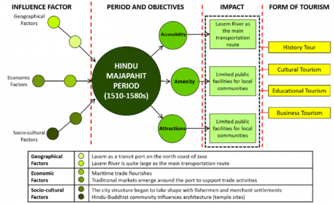
Figure 3. Influencing factors and impacts on the formation of tourism in the Hindu Majapahit period
The development of Lasem during the Hindu Majapahit period (circa 1510-580s) was shaped by a confluence of geographical, economic, and socio-cultural factors (Figure 3). Geographically, Lasem served as a strategic transit port along Java’s northern coastline, with the Lasem River functioning as a primary axis of transportation and connectivity. Economically, the city experienced significant growth in maritime trade, facilitated by the presence of traditional markets in the vicinity of the port, which supported regional commerce.
From a socio-cultural perspective, early urban structures began to emerge, marked by the establishment of fishing and trading settlements. The influence of Hindu-Buddhist traditions was reflected in the architectural landscape, including the construction of temples and religious monuments. During this period, public infrastructure remained limited and primarily served local needs; however, the formation of settlement patterns and religious sites contributed to the development of a distinct urban identity.
The reliance on the Lasem River as the central route of access, combined with existing archaeological remains and historical narratives of Lasem as a Majapahit-era port city, provides a strong foundation for its positioning as a destination for historical, cultural, educational, and heritage-based tourism.
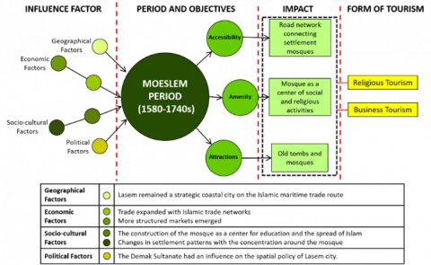
Figure 4. Influence and impact factors on tourism formation in the Muslim period
The development of Lasem during the Islamic period (circa 1580s-1740s) was shaped by a combination of geographical, economic, socio-cultural, and political factors (Figure 4). Geographically, Lasem maintained its role as a strategic coastal city situated along prominent Islamic maritime trade routes. Economically, the city witnessed the expansion of trade through Islamic commercial networks, which contributed to the emergence of more structured and integrated marketplaces.
From a socio-cultural perspective, the establishment of mosques played a central role, functioning not only as religious institutions but also as centers for education and Islamic propagation. This led to a transformation in the spatial organization of the city, with settlement patterns increasingly concentrated around mosque complexes. Politically, the influence of the Demak Sultanate was evident in Lasem’s spatial governance, particularly in the formulation of urban policies and the allocation of religious and public spaces.
The impact of these developments is reflected in the evolving accessibility system, characterized by road networks connecting mosques, residential areas, and market zones. Public facilities, especially mosques, began to serve as hubs of socio-religious activities, while the presence of historical mosques and Islamic tombs has contributed to the city’s cultural landscape. These enduring features underpin Lasem’s potential as a destination for religious, cultural, and heritage-based tourism.
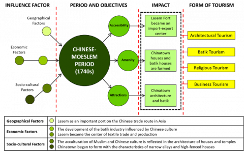
The development of Lasem during the Chinese-Muslim period (circa 1740s) was shaped by a combination of geographical, economic, and socio-cultural influences that significantly contributed to the city’s distinctive character (Figure 5). Geographically, Lasem emerged as a key port along the Chinese maritime trade route in Asia, enhancing its strategic importance within regional trade networks.
Figure 5. Influence and impact factors on tourism formation in the Muslim-Chinese period
Economically, this period marked the growth of the batik industry, which was deeply influenced by Chinese artistic traditions. Lasem became a major center for the production and trade of batik textiles, reinforcing its role as a regional economic hub. From a socio-cultural perspective, this era was characterized by intensive acculturation between Muslim and Chinese communities, particularly visible in domestic architecture and religious buildings. The emergence of a Chinatown district—distinguished by narrow alleyways, high-walled houses, and the coexistence of residences and temples—reflected this cultural synthesis.
The morphological impact of these developments is evident in the continued function of Lasem’s port as an import-export center, the establishment of Chinese residential enclaves, and the proliferation of hybrid architectural styles combining Chinese and local influences. These heritage elements have positioned Lasem as a destination for architectural, cultural, religious, batik, and commercial tourism, offering a unique narrative of cross-cultural integration and urban identity.
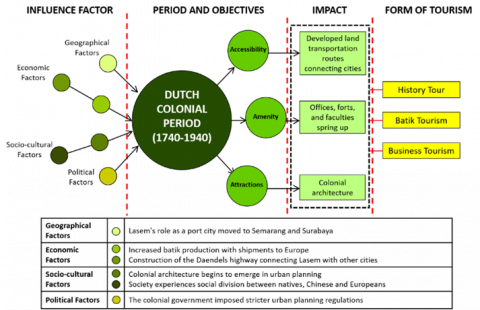
Figure 6. Influencing factors and impacts on the formation of tourism in the Dutch Colonial period
The development of Lasem during the Dutch colonial period (1740-1940) was shaped by various geographical, economic, socio-cultural, and political influences, each contributing to a distinct transformation of the city’s form and function (Figure 6). Geographically, Lasem’s strategic importance as a port city declined due to the shifting of regional trade hubs to Semarang and Surabaya, reducing its maritime relevance.
Economically, however, the batik industry experienced significant growth, with increasing exports to European markets. The construction of the Daendels Highway (Great Post Road) further integrated Lasem into the colonial land transportation network, enhancing overland connectivity with other urban centers.
Socio-culturally, the cityscape began to reflect European planning principles, marked by the emergence of colonial-style architecture and a rigid socio-spatial division among indigenous, Chinese, and European populations. Politically, the Dutch colonial administration imposed more formalized urban planning regulations, which reshaped the spatial logic of the city, emphasizing administrative control and segregation.
The combined effects of these transformations are evident in the development of road infrastructure, the construction of government offices, military forts, and public facilities, as well as the proliferation of colonial-era buildings. These enduring elements have become key assets for Lasem’s contemporary positioning as a destination for heritage tourism, batik commerce, and historical inquiry.
Figure 7. Influencing factors and impacts on the formation of tourism in the Japanese Colonial period
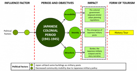
The development of Lasem during the Japanese occupation period (1941-1945) was primarily influenced by political and military considerations (Figure 7). The Japanese administration repurposed several existing buildings as military posts, significantly altering the function of urban spaces. Civilian mobility was restricted due to strict military policies, leading to a decline in public activity and the stagnation of urban infrastructure development.
Although large-scale urban expansion did not occur, the introduction of military installations—including bunkers and command posts—added a new layer to the city’s spatial narrative. These elements, while limited in number, became part of the city’s amenities and contributed to a distinct wartime morphology. The presence of these remnants has embedded a historical narrative within the urban landscape, reflecting the socio-political tensions of the occupation era.
As a result, the dominant form of tourism associated with this period is historical tourism, centered on Japanese military heritage and narratives of wartime resistance and occupation. These features offer opportunities for education, remembrance, and heritage interpretation within the broader context of Lasem’s urban history.
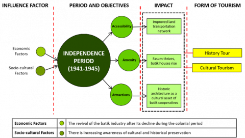
Between 1945 and 2000, economic and socio-cultural factors played a critical role in the post-independence revival of Lasem’s batik industry, which had experienced a decline during the colonial period. This era also witnessed a growing awareness of the importance of cultural and historical preservation, which became integral to the city’s socio-economic recovery (Figure 8).
Figure 8. Influencing factors and impacts on the formation of tourism in the Independence period
The impacts of these developments included improvements to the land transportation network, expansion of public facilities, and the reactivation of traditional batik houses as centers of production and community enterprise. Furthermore, historic architectural structures were increasingly repurposed as cultural assets and incorporated into cooperative batik enterprises, highlighting a synergy between heritage preservation and economic revitalization.
These transformations gave rise to forms of tourism centered on historical and cultural themes, particularly those emphasizing the conservation of tangible heritage and the continuity of the batik tradition. Lasem’s identity during this period was thus shaped by a fusion of cultural revivalism and adaptive reuse, establishing a foundation for sustainable heritage-based tourism.
Following Indonesia’s independence, the Lasem town square underwent revitalization led by the local government, restoring its role as a central public space. Today, the square serves as a venue for various communal activities, including night markets, cultural festivals, and religious events, all aimed at reactivating its function as a hub for social interaction and civic engagement. These initiatives have not only revived the square as a key morphological component of the city but have also catalyzed the growth of cultural and community-based tourism in Lasem [31].
In parallel, riverwalking activities have gained increasing attention amid the rising popularity of nature- and culture-based tourism. The Lasem River, historically a vital artery of daily life and trade, is now being reimagined as a tourist attraction that offers immersive experiences while simultaneously promoting the city’s historical significance and environmental assets [32]. These developments underscore a strategic shift toward the integration of natural and cultural elements in Lasem’s contemporary tourism planning, reinforcing the city's identity as a heritage-based destination.
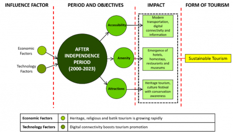
Between 2000 and 2023, the development of Lasem was primarily driven by economic transformation and technological advancement (Figure 9). The growth of heritage, religious, and batik tourism was significantly enhanced by the expansion of digital connectivity, which facilitated broader tourism promotion and information dissemination. Key impacts of this transformation include the modernization of transportation systems, the emergence of digital tourism platforms, and the development of essential amenities such as hotels, homestays, restaurants, and museums.
Figure 9. Influencing factors and impacts on the formation of tourism in the Post-Independence period
Furthermore, heritage tourism attractions and cultural festivals have increasingly emphasized the importance of cultural preservation, reflecting a growing awareness of safeguarding Lasem’s historical identity. The dominant tourism paradigm during this period is sustainable tourism, which seeks to balance economic growth with the protection and promotion of cultural assets.
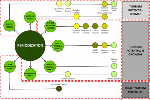
The periodization of Lasem’s transformation into a heritage tourism city is structured around a series of historical phases, each contributing distinct characteristics to its tourism profile (Figure 10). These periods include the Hindu Majapahit era, the Islamic period, the Chinese Muslim period, the Dutch colonial era, the Japanese occupation, the post-independence phase, and the contemporary period. Each era exerted a unique influence on the formation of tourism types—ranging from cultural, religious, and architectural tourism to batik, business, and historical tourism. Together, these stages have shaped Lasem into a city with a layered tourism identity rooted in its dynamic urban morphology and cultural continuity.
Figure 10. Diagram analyzing the influence of Lasem city morphology on the formation of a tourist city
In the subsequent phase, the potential for tourism development in Lasem evolved in tandem with a growing awareness of the importance of historical and cultural preservation. While historical tourism remained the dominant focus across multiple periods, other forms—such as business, batik, and religious tourism—emerged in response to specific socio-economic and cultural dynamics. In the post-independence period, cultural tourism gained greater prominence, indicating a shift away from colonial heritage narratives toward a reinforcement of local cultural identity. This transition has been further supported by the rise of educational and sustainable tourism, particularly in the modern era.
Overall, the conceptual framework illustrated in Figure 10 outlines the idealization stages of tourism potential, progressing from the formation stage, to development, and eventually to an ideal model. Sustainability is identified as a critical factor in ensuring the long-term preservation of cultural and historical heritage. With effective governance and inclusive management strategies, Lasem possesses the capacity to evolve into a model tourism destination—one that balances economic growth with the protection of cultural assets and historical continuity.
The evolution of Lasem’s tourism potential can be understood through three analytical stages:
a) Potential Tourism Town
This stage refers to a historical urban area with foundational tourism potential. The physical elements of city morphology—such as street networks, building types, and land use—are largely complete, although still concentrated within specific historic landscapes. The urban structure reflects the original city form, with diverse yet individually operated attractions. Tourism at this stage remains uncoordinated, with limited integration among accessibility, amenities, and attractions.
b) Emerging Tourism City
At this stage, the tourism potential becomes more visible and spatially expanded. The city's morphological components are categorized as highly complete and distributed across a broader landscape. The urban pattern includes both the original city and a commercial city form. Components of historic heritage are diverse or very diverse, and tourism activities are more varied, supported by improved accessibility and amenities. However, the system lacks full integration, and although preservation efforts are underway, cohesive planning is still in progress.
c) Integrated Tourism Town
This final stage represents an optimally developed heritage tourism city. Morphological elements are highly complete and span across the original, historic, and commercial urban zones. The heritage components are extensively diverse, and tourism infrastructure—accessibility, amenities, and attractions—has reached a high level of complexity and integration. Cultural heritage preservation is systematically embedded within development strategies, supported by technological innovation and sustainable tourism practices.
The findings of this study reveal that Lasem's tourism potential has evolved incrementally through three distinct stages, culminating in its characterization as an Integrated Tourism City. The initial phase, termed Potential Tourism City, is defined by the existence of foundational morphological elements, although lacking systematic development as a formal tourist destination. The second stage, Developing Tourism City, is marked by spatial expansion, where historic urban patterns extend beyond the original core to include emerging commercial areas. This phase also features a growing complexity in the integration of accessibility, amenities, and attractions. The final stage, Integrated Tourism City, represents the optimal condition—where the original settlement, heritage core, and commercial zones are functionally and spatially integrated, and supported by the use of digital technologies in tourism governance and heritage management.
This research contributes to the broader discourse on the relationship between historic urban morphology and sustainable tourism development. It proposes a conceptual framework that not only considers the economic potential of tourism but also emphasizes the centrality of spatial structure, heritage values, and historical continuity. The tripartite model of tourism staging introduced here offers a strategic tool for planning and managing historic urban destinations, particularly those with layered morphologies and multifunctional tourism potentials such as Lasem.
Nevertheless, the study acknowledges certain methodological and contextual limitations. The absence of comprehensive quantitative data—particularly regarding the socio-economic impacts of tourism at each developmental stage—limits the generalizability of the findings. Moreover, the reliance on a historical-interpretative method, while valuable for contextual depth, constrains the empirical validation of results. Contextually, fragmented historical documentation and limited local institutional capacity for heritage management present additional challenges.
Future research should adopt a mixed-methods approach that integrates geospatial analysis of land use changes with community perception surveys to assess the socio-cultural and environmental dimensions of tourism. Practically, the findings highlight the urgency of strengthening destination governance through participatory planning processes and institutional capacity-building. Policy recommendations include the formulation of zoning regulations grounded in historical morphology, the development of community-based conservation guidelines, and the implementation of digital tools for the interpretation and management of cultural tourism. Through these measures, Lasem can serve as a replicable model for sustainable heritage tourism at both the regional and national levels.
This journal article was written by Mutiawati Mandaka, Wiendu Nuryanti, and Dyah Titisari Widyastuti from the Doctoral Programme in Architecture, Department of Architecture and Planning, Faculty of Engineering, based on research on the Morphology of the Historic Tourism City of Lasem, Central Java, Indonesia, funded by the Directorate of Research of Universitas Gadjah Mada through the 2024 Final Project Recognition Programme (Grant No.: 4971/UN1.P1/PT.01.01/2024). The contents are the sole responsibility of the author.
[1] Ayudya, D., Ikaputra, I. (2022). Memahami perkembangan kota melalui urban morphology. Jurnal Pembangunan Wilayah dan Kota, 18(3): 235-245. https://doi.org/10.14710/pwk.v18i3.36135
[2] Lynch, K. (1960). The Image of the City. MIT Press.
[3] Mandaka, M., Nuryanti, W., Widyastuti, D.T. (2024). Impact of tourism on urban morphology in Lasem city, Indonesia. International Journal of Sustainable Development and Planning, 19(6): 2095-2104. https://doi.org/10.18280/ijsdp.190609
[4] Pan, L., Rongrong, Y., Ning, G., Sahar, S. (2022). A syntactical spatio-functional analysis of four typical historic Chinese towns from a heritage tourism perspective. Land, 11(12): 2181. https://doi.org/10.3390/land11122181
[5] Erham, A., Hamzah, A. (2014). The morphology of urban waterfront tourism: The local identity portray in Melaka and Makassar. Urban Economics & Regional Studies eJournal, 7(155): 1-14. https://doi.org/10.2139/ssrn.2498473
[6] Monica, K., Tejwant, Singh, B. (2022). Exploring the urban form of historic town to approach the sustainability debate: Case of Bijapur. AIP Conference Proceedings, 2721(1): 050008. https://doi.org/10.1063/5.0104102
[7] Ma, X., Tan, J., Zhang, J. (2022). Spatial-temporal correlation between the tourist hotel industry and town spatial morphology: The case of phoenix ancient town, China. Sustainability, 14(17): 10577. https://doi.org/10.3390/su141710577
[8] Liu, J., Wall, G. (2009). Resort morphology research: History and future perspectives. Asia Pacific Journal of Tourism Research, 14(4): 383-397. https://doi.org/10.1080/10941660903310029
[9] Đokić, V. (2009). Morphology and typology as a unique discourse of research. SAJ: Serbian architectural journal, 1(2): 107-130. https://raf.arh.bg.ac.rs/handle/123456789/481.
[10] Zahnd, M. (1999). Perancangan Kota Secara Terpadu. Kanisius.
[11] Jahn Kassim, S., Kamaruddin, K. (2023). Eco-inflections of the ‘Mandalic’city-form: Morphologies of the pre-colonial urban cores. In Eco-Urbanism and the South East Asian City: Climate, Urban-Architectural Form and Heritage, Singapore: Springer Nature Singapore, pp. 3-27. https://doi.org/10.1007/978-981-19-1637-3_1
[12] Al-Saaidy, H.J.E. (2020). Urban morphological studies (concepts, techniques, and methods). Journal of Engineering, 26(8): 100-111. https://doi.org/10.31026/j.eng.2020.08.08
[13] Gauthier, P., Gilliland, J. (2006). Mapping urban morphology: A classification scheme for interpreting contributions to the study of urban form. Urban Morphology, 10(1): 41-50.
[14] Al-Saaidy, H.J.E. (2020). Urban morphological studies (concepts, techniques, and methods). The Journal of Engineering, 26(8): 100-111. https://doi.org/10.31026/j.eng.2020.08.08
[15] Idak, Y. (2019). Methodological bases of the study of morphological characteristics of the city. Research and Science Today, 1(5): 22-29. https://doi.org/10.31435/rsglobal_ws/31052019/6509
[16] Yuliya, I. (2019). Interdisciplinary approaches to the study of morphology: Theoretical and methodological aspects. Introduction to city morphology. Planning and Forecasting, 38: 163-174. https://doi.org/10.21005/pif.2019.38.c-03
[17] Busheneva, Y. (2022). Disciplinary image of city morphology in urban planning. Vìsnik Nacìonalʹnogo Unìversitetu "Lʹvìvsʹka Polìtehnìka", 4(1): 83-94. https://doi.org/10.23939/sa2022.01.083
[18] Navastara, A.M. (2017). Urban morphology of European and Asian cities: A descriptive case study. Journal of Architecture and Urbanism, 12(1): 1-10. https://doi.org/10.12962/j2716179x.v12i1.5218
[19] Smailes, A.E. (1955). Struktur Tata Ruang Kota. Pustaka Pelajar.
[20] Moudon, A.V. (1997). Urban morphology as an emerging interdisciplinary field. Urban Morphology, 1(1): 3-10.
[21] Sima, Y., Zhang, D. (2009). Comparative precedents on the study of urban morphology. Proceedings of the 7th International Space Syntax Symposium, 103: 1-8.
[22] Conzen, M.R.G. (1960). Alnwick, Northumberland: A study in town-plan analysis. Transactions and Papers (Institute of British Geographers), (27): iii-122. https://doi.org/10.2307/621094
[23] Whitehand, J.W.R. (1977). The basis for an historico-geographical theory of urban form. Transactions of the Institute of British Geographers, 2(4): 400-416. https://doi.org/10.2307/621839
[24] Ashworth, G.J., Tunbridge, J.E. (2000). The Tourist-Historic City. Routledge.
[25] Gospodini, A. (2004). Urban morphology and place identity in European cities: Built heritage and innovative design. Journal of Urban Design, 9(2): 225-248. https://doi.org/10.1080/1357480042000227834
[26] Boussaa, D., Madandola, M. (2024). Cultural heritage tourism and urban regeneration: The case of Fez Medina in Morocco. Frontiers of Architectural Research, 13(6): 1228-1248. https://doi.org/10.1016/j.foar.2024.04.008
[27] Song, C., Yang, J., Wang, L., Li, Y., Zhi, Y., Xia, J.C. (2022). Spatiotemporal reconstruction and drivers of tourism-oriented towns: A case study of Jinshitan. Frontiers in Environmental Science, 10: 1013908. https://doi.org/10.3389/fenvs.2022.1013908
[28] District, X., District, C. (2017). Study on the landscape pattern of Dalian Jinshitan national holiday resort in the context of tourism urbanization. Journal of Urban Management, 5(3): 1-14. https://doi.org/10.1142/S234574811750018X
[29] Anh, L.T.K., Duc, L.A., Tuan, P.N. (2024). Analysing the urban morphology of Hoi An ancient city, Quang Nam Province in sustainable coastal tourism, vision to 2045. Journal of Science and Technology, 22(11C): 1-12. https://doi.org/10.31130/ud-jst.2024.547E
[30] Groat, L.N., Wang, D. (2013). Architectural Research Methods. John Wiley & Sons.
[31] Santoso, R.E., Sari, S.R., Rukayah, R.S. (2020). Peran masyarakat Tionghoa terhadap perkembangan kawasan heritage di Kota Lasem, Kabupaten Rembang. Modul, 20(2): 84-97. https://doi.org/10.14710/mdl.20.2.2020.84-97
[32] Intan, Putri, C., Puri, Bestari, M., Yuliani, W. (2023). Digital storytelling in cultural tourism: A sustainable communication approach at the Lasem Heritage Foundation. International Journal of Management, Entrepreneurship, Social Science and Humanities, 6(1): 45-69. https://doi.org/10.31098/ijmesh.v6i1.1348