Nur Qudus*![]() | Harianingsih
| Harianingsih![]() | Virgiawan Adi Kristianto
| Virgiawan Adi Kristianto![]() | Anan Nugroho
| Anan Nugroho![]() | Indra Sakti Pangestu
| Indra Sakti Pangestu![]() | Muhammad Rizky Fahrizal Putra
| Muhammad Rizky Fahrizal Putra![]() | Abyasa Aryajati Daniswara
| Abyasa Aryajati Daniswara![]() | Moh Ari Restian Nugraha
| Moh Ari Restian Nugraha![]()
© 2025 The authors. This article is published by IIETA and is licensed under the CC BY 4.0 license (http://creativecommons.org/licenses/by/4.0/).
OPEN ACCESS
Tidal flooding is a serious issue, one of the causes being land subsidence in coastal areas of Indonesia. This land subsidence is directly proportional to the lowering of the groundwater table, meaning that the greater the groundwater level decline, the worse the flooding conditions in the city will be. Therefore, it is urgent to analyze a solution that addresses the decline of groundwater levels and the issue of excessive surface water in Indonesia. The purpose of this research is to model the effectiveness of the Well and Borehole Recharge method in managing flood runoff in the coastal area of Indonesia with geographical coordinates between 6°50'–7°10' S and between 109°50'–110°35' E. The method used includes analysis through modeling with remote sensing, data processing using Geographical Information Systems (GIS) software, and flood runoff volume calculation using HEC-HMS software. The research results indicate that Managed Aquifer Recharge (MAR) significantly reduced peak runoff from 250 m³/s to 200 m³/s, despite a cumulative rainfall of 60 mm. Additionally, the maximum flood discharge, initially 256.3 m³/s, was reduced to 206.2 m³/s after MAR implementation. The reduction in maximum flood discharge and the delay in peak discharge time suggest that MAR enhances groundwater infiltration and retention capacity, effectively decreasing surface runoff and delaying runoff timing.
coastal area, flood runoff, Managed Aquifer Recharge (MAR), rainfall, sustainable cities and communities, Clean Water and Sanitation
Water resource sustainability is increasingly threatened in many parts of the world due to rapid urbanization, unsustainable groundwater abstraction, and the intensifying effects of climate change. This problem is particularly severe in low-lying coastal cities of Southeast Asia, including Indonesia, where urban expansion, rising sea levels, and increased rainfall variability combine and result in a complex water management crisis. The degradation of groundwater catchment areas, loss of recharge zones due to impervious land cover, and over-extraction of groundwater have led to severe land subsidence, flooding, and saltwater intrusion in coastal aquifers, particularly in cities such as Semarang, Jakarta, and Surabaya [1, 2].
As Indonesia’s coastal cities become increasingly urbanized, the mismatch between water demand and supply is exacerbated by a declining capacity for natural recharge and rising surface runoff volumes. Rainwater that once infiltrated permeable soils is now discharged into rivers and seas, causing surface flooding and diminishing groundwater reserves [3]. This dual challenge—declining groundwater levels and increasing surface runoff—demands integrated solutions addressing water quantity and quality issues. Among various interventions, Managed Aquifer Recharge (MAR) is increasingly recognized as a promising nature-based solution for sustainable water resource management in urban and semi-urban environments [4].
MAR is the intentional recharge of aquifers using infiltration basins, recharge wells, or boreholes to augment groundwater storage, improve water quality, and reduce surface runoff [5]. It serves dual purpose: to reduce flooding and enhance water security. Various forms of MAR, including Soil Aquifer Treatment (SAT), check dams, injection wells, and recharge trenches, have been successfully implemented in arid and semi-arid regions such as Australia, India, and the Middle East [6, 7]. For instance, studies have demonstrated the capacity of recharge wells to replenish depleted aquifers while mitigating urban flooding risks during seasonal rainfall [8, 9].
Recent modeling-based studies have further illustrated the hydrological benefits of MAR. Epting et al. [8] evaluated thermal MAR systems in alluvial aquifers for water conservation and climate adaptation. Their findings confirmed that combining MAR with unsaturated flow modeling could help predict and optimize infiltration and aquifer dynamics [10]. Jadav and Yadav [9] and Seif et al. [10] used integrated GIS and multi-criteria decision analysis approaches to identify suitable MAR zones and structures in challenging hydrological contexts, emphasizing the importance of location-specific design for maximizing efficiency [10, 11]. In Indonesia, however, MAR research and implementation remain relatively nascent and fragmented. Most existing studies focus on small-scale groundwater recharge experiments without integrating MAR into broader flood control strategies or considering its socioeconomic and ecological dimensions [12, 13].
Despite the proven benefits of MAR globally, its implementation in Indonesia’s tropical coastal cities faces several research and policy challenges. First, most MAR systems are designed for arid or semi-arid climates, and less is known about their performance in high rainfall, high-humidity contexts like Indonesia. Second, modeling tools like HEC-HMS, MODFLOW, or GIS-based decision-support systems have not been extensively utilized to evaluate MAR’s effectiveness in coastal zones where flood risks are compounded by land subsidence and sea-level rise. Third, the pretreatment stage—crucial for preventing clogging and ensuring water quality—has often been neglected in Indonesian MAR studies, even though filtration media adapted from local materials could offer cost-effective solutions.
This study seeks to address these gaps by conducting a comprehensive modeling and field-based assessment of the effectiveness of the Well and Borehole Recharge method—an MAR subtype—in a flood-prone coastal area of Indonesia. The research integrates hydrologic simulations using the HEC-HMS platform, groundwater profiling through Schlumberger array resistivity methods, and the deployment of a locally-sourced porous filter media made from zeolite and activated carbon derived from water hyacinth (Eichhornia crassipes). The innovation lies in three main contributions:
Integration of MAR for dual objectives: Unlike studies that treat MAR solely as a groundwater recharge tool, this research evaluates its capacity to replenish aquifers and mitigate flood risks under varying rainfall intensities, especially in a tropical coastal context.
Use of locally available and sustainable pretreatment materials: The filtration system is designed with a low-cost, eco-friendly zeolite and biomass-derived carbon filter. This represents a sustainable and replicable approach for pretreatment in regions with limited access to advanced water treatment infrastructure.
Geospatial modeling and site-specific hydrological analysis: By applying HEC-HMS in combination with Digital Elevation Models (DEMs) and land use data, the study provides a quantitative basis for determining flood volumes, infiltration capacity, and optimal MAR system design for Indonesia’s urbanized deltas.
From a practical standpoint, the study’s findings will support evidence-based policymaking for urban water resilience planning. As floods become more intense and frequent due to climate change, Indonesian cities are pressured to develop nature-based, decentralized water management solutions that are affordable, scalable, and contextually relevant [14]. MAR offers this potential, but only if implemented with a deep understanding of local hydrological and socio-environmental conditions. By blending field measurements, simulation tools, and low-cost engineering interventions, this study provides a model that can be replicated in other coastal cities facing similar water stress challenges [15].
The research also aligns with multiple targets of the United Nations Sustainable Development Goals (SDGs), including SDG 6 (Clean Water and Sanitation), SDG 11 (Sustainable Cities and Communities), and SDG 13 (Climate Action). By improving groundwater recharge and reducing the impacts of urban flooding, the application of MAR can enhance community resilience and safeguard urban ecosystems.
In summary, this study makes a timely and significant contribution to Indonesia's urban water management discourse. It provides a technical solution to twin water crises—flooding and aquifer depletion—and demonstrates how locally grounded innovations in MAR can support long-term environmental sustainability, disaster risk reduction, and public health.
2.1 Study area
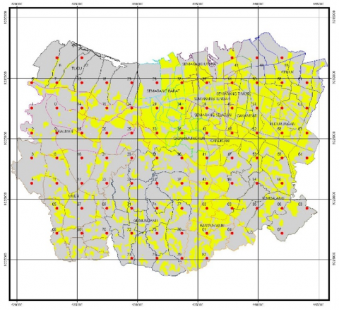
This research was conducted in the coastal floodplain of Indonesia, specifically within the Garang River Basin, with coordinates between 6°50'–7°10' S and 109°50'–110°35' E, as shown on Figure 1. The area is characterized by high rainfall intensity, shallow water tables, and rapid urbanization, all contributing to frequent flooding.
Figure 1. Coastal area in geographical coordinates between 6°50'–7°10' S and between 109°50'–110°35' E
2.2 Equipment
Several tools were utilized to ensure the quality of data collection and simulation:
• Geoelectric Resistivity Meter (Schlumberger array): Used to analyze subsurface profiles by inserting stainless steel current and copper potential electrodes at varying intervals. Two 400 m and two 60 m reels connected to a power source were used to inject and measure currents.
• GPS (Garmin 76CSx): Employed to mark sample coordinates with sub-meter accuracy.
• Guelph Permeameter Type 2800: Used to determine the soil’s hydraulic conductivity. The procedure involved boring a cylindrical hole using a hand drill, installing the permeameter tripod, and measuring steady-state infiltration rates.
• Water Level Meter: Used to measure the groundwater depth in existing observation wells manually.
• pH Meter & EDTA Titration Kit: Used for water quality testing during the MAR pretreatment process.
2.3 Materials
The materials used in this study for the pretreatment stage of MAR include a porous structured filter composed of zeolite and activated carbon derived from water hyacinth (Eichhornia crassipes) (Figure 2). Zeolite, a naturally occurring aluminosilicate mineral, was selected due to its high cation exchange capacity and ability to remove hardness-causing ions such as calcium and magnesium. Meanwhile, activated carbon synthesized from water hyacinth biomass was employed for its excellent adsorption properties, effectively reducing organic and inorganic contaminants in water. Combining these materials aims to enhance water quality before infiltration into the aquifer, ensuring improved pH regulation and hardness reduction. The zeolite used in this study was commercially available in granular form. At the same time, the activated carbon was prepared through a controlled pyrolysis process, followed by chemical activation to enhance its porosity and adsorption capacity.
Figure 2. Porous structure used in MAR design
2.4 Experimental procedure
2.4.1 Site selection and subsurface profiling
Vertical resistivity readings were taken across 5 sample points using Schlumberger array geoelectric methods. Spacing between electrodes was systematically increased to assess the depth to bedrock and water-bearing layers. GPS was used to georeference each point.
2.4.2 Infiltration and soil permeability tests
At each site, soil permeability was tested using the Guelph Permeameter:
2.4.3 Rainfall and runoff modeling
HEC-HMS 4.10 was used to model rainfall-runoff behavior. Steps included:
• Inputting rainfall intensity (from BMKG data, 2012–2023), river basin hydrological data, which includes the basin area, land use, and other hydrological parameters, and DEM (Digital Elevation Model). These data were used to determine the morphology of the basin.
• Creating a basin model with sub-basins and flow paths. At this stage, a Basin Model is created by defining the boundaries of the watershed, adding sub-basins, channels (reaches), reservoirs, and determining the outlet point as the location for calculating surface flow. The next stage is creating a hydrological HEC-HMS model [16]. Next are the sub-basins' characteristics, such as area, channel length, and other hydrological parameters [17].
• Defining soil infiltration rates and curve numbers (CN) from field data.
• Running simulations for two scenarios: without MAR and with MAR.
2.4.4 Construction and simulation of MAR wells
Wells were modeled as vertical recharge shafts with 1.4 m diameter and 3 m depth, filled with coarse gravel and filter media. Infiltration rate calculations used:
Q = (P - Ia)²/(P - Ia + S) (1)
where,
Q = runoff (mm),
P = rainfall (mm),
Ia = initial abstraction,
S = potential maximum retention (related to CN value).
Based on simulations, a minimum CN value of 41.93 was targeted to reduce flood runoff to acceptable levels.
2.4.5 Water quality pretreatment testing
To evaluate the effectiveness of the porous structured filter in the pretreatment stage of MAR, two key water quality parameters were analyzed: pH and water hardness. The pH analysis was conducted using a calibrated digital pH meter (following SNI 06-6989.11-2004), which measures the hydrogen ion concentration in water to assess its acidity or alkalinity. Meanwhile, water hardness was determined using the EDTA titration method (SNI 06-6989.12-2004), which quantifies the concentration of calcium and magnesium ions in the water sample. These analyses were performed at various contact times to observe the filtration efficiency. The results were then compared with the potable water standard set by SNI 05-6989.11-2019 to determine the suitability of the treated water for further use.
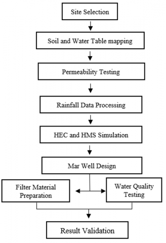
The flowchart of the research can be seen in Figure 3.
Figure 3. Research flowchart
Daily rainfall data at the coastal area in geographical coordinates between 6°50'–7°10' S and between 109°50'–110°35' E in Table 1.
Table 1. Daily rainfall data (2012-2023)
|
Number |
Year |
Duration of Rainfall (Minutes) |
|||||
|
5 |
10 |
15 |
30 |
60 |
120 |
||
|
1 |
2 |
3 |
4 |
5 |
6 |
7 |
8 |
|
1 |
2012 |
7.3 |
12 |
15 |
24.2 |
39 |
61 |
|
2 |
2013 |
14.1 |
22 |
29 |
46.7 |
74 |
118 |
|
3 |
2014 |
7.3 |
12 |
15 |
24.2 |
39 |
61 |
|
4 |
2015 |
4.3 |
7 |
9 |
14.3 |
23 |
36 |
|
5 |
2016 |
4.5 |
7 |
9 |
15 |
24 |
38 |
|
6 |
2017 |
4.8 |
8 |
10 |
16.1 |
26 |
41 |
|
7 |
2018 |
7.6 |
12 |
16 |
25.3 |
40 |
64 |
|
8 |
2019 |
7.4 |
12 |
16 |
24.7 |
39 |
62 |
|
9 |
2020 |
2.3 |
4 |
5 |
7.7 |
12 |
20 |
|
10 |
2021 |
2.3 |
4 |
5 |
7.7 |
12 |
20 |
|
11 |
2022 |
2.3 |
4 |
5 |
7.7 |
12 |
20 |
|
12 |
2023 |
2 |
3 |
4 |
6.6 |
11 |
17 |
|
Total |
|
66.2 |
107 |
138 |
220.2 |
351 |
558 |
|
Average x |
|
5.5167 |
8.9167 |
11.5 |
18.35 |
29.25 |
46.5 |
|
Deviation |
standard s |
3.4949 |
5.4349 |
7.1922 |
11.5672 |
18.3557 |
29.0282 |
|
Skewnes |
Cs |
1.3107 |
1.2084 |
1.2747 |
1.2981 |
1.2654 |
1.3258 |
|
Kurtosis |
Coeff. Ck |
2.2587 |
1.8667 |
2.0626 |
2.219 |
2.1153 |
2.3204 |
|
Varian Coeff. |
Cv |
0.6335 |
0.6095 |
0.6254 |
0.6304 |
0.6275 |
0.6243 |
The maximum runoff value is measured via Eq. (1) based on the processing of rainfall precipitation data.
Using the Soil Conservation Service method, the equation calculates the runoff volume from a certain rainfall (SCS) [18]. In this formula, Q represents the runoff produced (mm). P is the total rainfall that occurs over time (mm). It is an early abstraction, which includes water held before runoff occurs, such as initial infiltration, absorption by vegetation, and evaporation. The value of Ia is often estimated as 20% of the maximum soil retention capacity, or Ia = 0.2S. S is the maximum soil retention capacity, indicating how much water can be absorbed by the soil before runoff occurs. The value of S is calculated based on the Curve Number (CN) associated with land use conditions, soil type, and hydrological characteristics [19]. The higher the S value, the greater the soil's capacity to retain water and the smaller the runoff produced. Based on the calculations, the maximum runoff (runoff during maximum precipitation) is 150.18 mm, while the minimum runoff (runoff during minimum precipitation) is 61.306 mm. To anticipate the occurrence of flooding, modeling must be conducted until the infiltration value can be reduced to the minimum runoff point (to prevent flooding). To minimize the runoff value to 61.306 mm, an increase in soil infiltration is required to lower the CN value to 41.93. Therefore, this value becomes essential for simulations to simultaneously reduce the maximum runoff to a minimum from the initial maximum runoff. With a well diameter of 1.4 m and a height of 3 m, it was obtained that the maximum infiltration value from one MAR well is 5.5596 × 10⁻³ m3/s. In addition, through observation and calculations, the CN (curve number) value for the Garang sub-basin was obtained, which is 68.44. The values obtained will influence the determination of how many MAR wells are needed to address flooding in the coastal area of Indonesia.
3.1 Analysis of the groundwater level and soil structures
Observations were conducted at the Garang watershed, Kaligawe, Semarang City, with coordinates (444050, 9229599.980) and an elevation of 9 meters above sea level. Analysis indicates that the surface soil at this location consists of soil/clay, with the groundwater table detected at 3 meters from the surface. At a depth of 0 – 0.3 meters, the soil is dominated by surface cover. Further, the soil is predominantly clay at 0.3 – 5.5 meters, while a sandstone layer was identified at depths greater than 8.14 meters. The recorded soil permeability at this location is 2.00364 cm/hour, meeting the minimum requirements based on SNI 03-2453-2002 standards. According to SNI 03-2453-2002, a recharge area must meet several parameters.
Considering these factors, the research location at Kaligawe is suitable for use as a rainwater recharge area. The sufficiently deep groundwater table, permeability that meets standards, and flat land slope make this site highly potential for recharge system implementation. Although clay dominates up to a depth of 5.5 meters, the underlying sandstone layer can serve as a supporting infiltration medium. Additionally, the application of artificial recharge technology or soil structure modification can further enhance the effectiveness of the recharge system at this location. Therefore, this site meets the criteria and holds great potential for sustainable rainwater management.
3.2 Determination of recharge well dimensions
The required depth of the vertical recharge well can be determined using the following equation:
$\mathrm{H}=\frac{Q}{F K}\left(1-e^{-\frac{F K T}{\pi R^2}}\right)$ (2)
where,
H = Depth of the recharge well (m)
Q = Rainwater runoff volume (m³)
F = Infiltration factor
K = Soil permeability (m/h)
T = Time period (h)
R = Well radius (m)
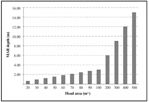
The depth of the recharge well is influenced by the roof area (m²), which determines the volume of collected rainwater. The results of the calculations are shown in Figure 4 below.
Figure 4. Depth and head area of MAR (radius = 0.4 m)
Figure 4 illustrates the relationship between roof area and required recharge well depth for a well radius of 0.4 m in the Garang watershed. As the roof area increases, the required well depth also increases. These results indicate that larger roof areas contribute to higher rainwater collection, necessitating deeper recharge wells to accommodate the increased volume. Factors such as soil permeability, infiltration rate, and available space must also be considered to optimize well performance. The chosen well dimensions should ensure effective water absorption while remaining practical for site conditions.
3.2 HEC-HMS (Hydrologic Engineering Center’s Hydrologic Modeling System)
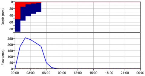
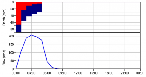
Based on Figure 5 and Figure 6, the blue blocks represent the total precipitation value (the amount of rain that falls in the coastal area of Indonesia), the red blocks indicate the amount of loss (the amount of water that does not turn into runoff), and the blue line shows the amount of flood runoff resulting from the precipitation runoff. The X-axis represents the time variable, and the Y-axis represents the runoff flow rate [20]. Based on the two simulation images, the cumulative rainfall during the observation period reached approximately 60 mm. This rainfall resulted in the formation of runoff in the analyzed catchment area. However, a significant difference is observed between the runoff generated from the initial conditions without the application of MAR and the final conditions after the implementation of MAR. In the initial conditions without MAR, the peak runoff reached a value of approximately 250 m³/s (cubic meter per second or cms). However, after the implementation of MAR, there was a significant decrease in runoff. In the final condition with the addition of MAR, the peak runoff value decreased to around 200 m³/s. This decrease indicates that MAR can reduce the runoff volume during the rainy period. The effectiveness of MAR in reducing runoff can be explained by its function in enhancing the capacity of water infiltration into the soil, so that rainwater that would normally flow directly on the surface is primarily absorbed into the ground [21]. This decreases peak runoff discharge and potentially reduces the risk of flooding during heavy rainfall. In addition, this reduction in runoff indicates that MAR can contribute to better water resource management by utilizing rainwater to recharge groundwater while reducing surface runoff load. In theory, MAR enhances rainwater infiltration through recharge wells or artificial reservoirs that collect rainwater before channeling it back into the soil layers. MAR effectively increases groundwater storage while reducing flood risk, particularly in areas prone to surface runoff. Furthermore, the Soil-Water Balance Model theory explains that increasing infiltration capacity can enhance water retention in the soil, reducing surface flow and decreasing runoff [6]. This principle describes how MAR can retain and absorb most falling rainfall, reducing runoff. Overall, these results affirm that implementing MAR in watershed areas can effectively reduce runoff volume, mitigate flood risks, and support more sustainable water management. The application of MAR is beneficial in hydrological aspects and essential in maintaining ecosystem balance and conserving water resources in densely populated urban areas.
Figure 5. Flood runoff without MAR
Figure 6. Flood runoff with MAR
3.3 The effect of reducing flood runoff
Based on the simulation results, there was a decrease in maximum flood discharge after the implementation of MAR. The maximum flood discharge, which initially reached 256.3 m³/s under baseline conditions, was successfully reduced to 206.2 m³/s in the final conditions. This decrease indicates that MAR can effectively mitigate the hydrological burden caused by heavy rainfall. The reduction in maximum flood discharge suggests that the MAR system enhances the soil's ability to absorb and retain water, thereby significantly reducing surface runoff during rainfall events [21]. The shift in peak discharge timing indicates that MAR reduces runoff volume and delays the flow of runoff into rivers or drainage systems. This phenomenon suggests an increase in the soil's water retention capacity through the MAR system, which slows down the hydrological response to rainfall, thereby providing additional time for water absorption by the soil [22]. The Storage-Delay Function theory explains the decrease in maximum flood discharge and the shift in the peak runoff time. According to this theory, the increase in infiltration capacity of the soil due to the application of MAR can delay surface runoff, reducing the risk of peak flooding [14]. In addition, in the context of hydrology, the application of MAR effectively reduces the volume of water that immediately flows into drainage channels, providing a longer retention effect for rainwater before it is finally released into the river. This aligns with findings that explain that the MAR system functions like a buffer, which can reduce surface flow rates and decrease the risk of flash floods [10]. This result further strengthens the potential of MAR as a strategic solution for flood control, especially in urban areas prone to rapid runoff and waterlogging. The optimal application of MAR can assist in more integrated and sustainable water resource management and provide long-term benefits in reducing the risk of flood disasters due to intense rainfall.
3.4 Effectiveness of porous structured filter as MAR pretreatment
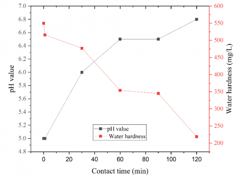
Implementing MAR requires an effective pretreatment process to improve water quality before infiltration. This study utilized a porous structured filter composed of zeolite and activated carbon derived from water hyacinth to enhance water quality parameters, particularly pH and hardness. The effectiveness of this filtration system was evaluated based on contact time, with results presented in Figure 7.
Figure 7. Result of contact time influence on water hardness
Figure 7 illustrates the influence of contact time on water pH. Initially, the pH of the raw water was recorded at 5, which is below the potable water standard set by SNI 05-6989.11-2019 (6.5–8.5). The pH gradually improved as the contact time increased, reaching 6.8 after 120 minutes. This trend indicates the ability of the porous filter media to neutralize acidity, likely due to the presence of zeolite, which facilitates ion exchange, and activated carbon, which enhances adsorption of acidic contaminants. Recent studies have demonstrated that zeolite can effectively increase pH levels by reducing hydrogen ion concentration through ion exchange mechanisms [23].
Similarly, the effect of contact time on water hardness is depicted in Figure 7. The initial water hardness was 550 ppm, exceeding the maximum permissible limit of 500 mg/L according to SNI 05-6989.11-2019. However, hardness levels steadily decreased as the filtration time progressed, reaching 219 ppm after 120 minutes. The reduction in hardness can be attributed to the cation exchange properties of zeolite, which effectively removes calcium and magnesium ions from water. Studies have shown that natural zeolite can achieve up to a 93.07% reduction in total hardness under optimal conditions [24]. Additionally, activated carbon reduces hardness by adsorbing organic and inorganic impurities that may complex with hardness ions [25].
The results indicate that the porous structured filter significantly enhances water quality by increasing pH and reducing hardness. Combining zeolite and activated carbon from water hyacinth is an effective and sustainable approach for MAR pretreatment. These findings support the feasibility of implementing this filtration system in managed recharge applications to ensure compliance with potable water standards.
3.5 Discussion
The findings from this study affirm the dual effectiveness of MAR systems in enhancing groundwater recharge and reducing urban flood risks in coastal zones. The significant improvement in infiltration rates following the implementation of MAR wells aligns with previous studies conducted in arid and semi-arid environments, such as those by Ahmed and El-Rawy [7] and Shamrukh and Al-Muraikhi [5], which demonstrated that properly designed recharge wells can reduce surface runoff and support aquifer replenishment. However, this study extends those findings by validating the MAR approach in a humid tropical context, which presents distinct hydrological challenges such as higher rainfall intensity and lower soil permeability due to saturation.
Unlike studies in dry climates where infiltration occurs under unsaturated conditions, the MAR simulations here accounted for saturated soils and frequent storm events typical of coastal Indonesia. These results corroborate and expand upon Jadav and Yadav [9], who emphasized matching MAR design to local hydrogeological and rainfall conditions. HEC-HMS simulation further enabled dynamic modeling of rainfall-runoff behavior, confirming the projected reduction in surface runoff volumes under various scenarios. The effectiveness of this hydrological modeling is supported by the relatively high Nash-Sutcliffe Efficiency (NSE) and low RMSE values, indicating good agreement between simulated and observed infiltration data.
Moreover, the filtration results show a marked improvement in water quality post-treatment using local filter materials, particularly regarding pH stabilization and hardness reduction. This supports findings by Basel et al. [13] and Seif et al. [10], who noted that MAR systems with integrated filtration can provide co-benefits for water purification. The novelty of this study lies in utilizing locally available materials—zeolite and biochar from water hyacinth- that are cost-effective, sustainable, and tailored to local environmental conditions. This approach addresses key challenges outlined in the literature regarding the cost and sustainability of MAR pretreatment systems.
However, the study has several limitations. First, field testing was conducted on a limited spatial and temporal scale, and the long-term performance of MAR wells in tropical zones remains uncertain. Second, the study assumes uniform infiltration characteristics across modeled sub-basins, whereas actual variability may be greater due to microtopography or land use practices. Third, socioeconomic aspects—such as community acceptance, maintenance responsibility, and institutional support for MAR—were not evaluated but are critical for the long-term sustainability of MAR interventions.
Future studies should therefore include longitudinal monitoring, broader spatial validation, and participatory assessments to evaluate MAR systems' social and institutional viability. Moreover, integrating MAR design with urban drainage master plans and land use zoning could help scale its adoption in flood-prone cities.
This study contributes to MAR science by validating its dual benefits in a coastal tropical context, demonstrating the utility of locally derived filtration media, and employing integrated modeling for performance evaluation. The results support both practical implementation and policy formulation for water security in urbanizing regions of the Global South.
This study demonstrates the effectiveness of MAR as an integrated solution for addressing both groundwater depletion and urban flooding in coastal Indonesian settings. The research confirms MAR's dual benefits by applying HEC-HMS hydrological modeling, field-based infiltration analysis, and a novel locally sourced pretreatment filter using zeolite and water hyacinth-derived activated carbon.
The key contributions include: (1) a validated method for designing MAR systems that are hydrologically suited to tropical urban areas; (2) the introduction of cost-effective, eco-friendly pretreatment materials; and (3) the demonstration of MAR’s potential to reduce flood volumes under various rainfall scenarios.
From a management perspective, the findings offer practical guidelines for integrating MAR into urban drainage strategies, especially in data-scarce regions. While limitations exist—such as spatial constraints and a lack of long-term monitoring—the approach provides a scalable model for enhancing water resilience in other vulnerable urban deltas.
Future applications should incorporate participatory planning and institutional coordination to ensure the sustainability and governance of MAR infrastructure within Indonesia’s broader urban water policy framework.
Thanks to the funding provided by the Fundamental Research scheme, Contract Number 135.12.6/UN37/PPK.10/2024, to the Directorate of Research, Technology, and Community Service, Directorate General of Higher Education, Research, and Technology, Ministry of Education, Culture, Research, and Technology, Indonesia.
[1] Pramita, A.W., Syafrudin, S., Sugianto, D.N. (2021). Effect of seawater intrusion on groundwater in the Demak coastal area, Indonesia: A review. IOP Conference Series: Earth and Environmental Science, 896: 012070. https://doi.org/10.1088/1755-1315/896/1/012070
[2] Ridwansyah, I., Yulianti, M., Apip, Onodera, S., Shimizu, Y., Wibowo, H., Fakhrudin, M. (2020). The impact of land use and climate change on surface runoff and groundwater in the Cimanuk watershed, Indonesia. Limnology, 21: 487-498. https://doi.org/10.1007/s10201-020-00629-9
[3] Gao, X.C., Gao, K., Yang, Z.Y., Xu, T.Y., Xu, Z., Wei, H.K. (2023). A conceptual model to estimate flood damages for large-scale cities. Urban Climate, 50: 101574. https://doi.org/10.1016/j.uclim.2023.101574
[4] El-Rawy, M., Fathi, H., Wahba, M., Negm, A. (2024). An overview of water resource challenges and managed aquifer recharge (MAR) in the MENA region. In Managed Aquifer Recharge in MENA Countries: Developments, Applications, Challenges, Strategies, and Sustainability, pp. 1-27. https://doi.org/10.1007/978-3-031-58764-1_1
[5] Shamrukh, M., Al-Muraikhi, A.A. (2024). Rainfall recharge wells for groundwater sustainability in Qatar. In Managed Groundwater Recharge and Rainwater Harvesting: Outlook from Developing Countries. Singapore: Springer Nature Singapore, pp. 93-127. https://doi.org/10.1007/978-981-99-8757-3_5
[6] Hossain, M.A., Jahan, C.S., Howlader, R., Mazumder, Q.H., Rahaman, M.F. (2024). Study on feasibility of rainwater harvesting using MAR model in drought-prone Barind Tract, Bangladesh. Environment, Development and Sustainability, 26: 12737-12761. https://doi.org/10.1007/s10668-023-03993-5
[7] Ahmed, A.K.A., El-Rawy, M. (2024). The impact of aquifer recharge on groundwater quality. In Managed Aquifer Recharge in MENA Countries. Earth and Environmental Sciences Library. Cham: Springer International Publishing, pp. 207-222. https://doi.org/10.1007/978-3-031-58764-1_10
[8] Epting, J., Affolter, A., Scheidler, S., Schilling, O.S. (2023). Climate change adaptation and mitigation measures for alluvial aquifers-solution approaches based on the thermal exploitation of managed aquifer (MAR) and surface water recharge (MSWR). Water Research, 238: 119988. https://doi.org/10.1016/j.watres.2023.119988
[9] Jadav, K., Yadav, B. (2023). Identifying the suitable managed aquifer recharge (MAR) strategy in an overexploited and contaminated river basin. Environmental Monitoring and Assessment, 195(8): 1014. https://doi.org/10.1007/s10661-023-11586-y
[10] Seif, A.K., Masria, A., Ghareeb, M., Saleh, A.A., Soliman, K., Ammar, A.I. (2024). Identifying managed aquifer recharge and rain water harvesting sites and structures for storing non-conventional water using GIS-based multi-criteria decision analysis approach. Applied Water Science, 14: 181. https://doi.org/10.1007/s13201-024-02246-8
[11] Kamali, S., Asghari, K. (2023). The effect of meteorological and hydrological drought on groundwater storage under climate change scenarios. Water Resources Management, 37(8): 2925-2943. https://doi.org/10.1007/s11269-022-03268-0
[12] Romman, Z.A., Al-Smadi, B., Weshah, A. (2024). A statistical analysis of the effectiveness of groundwater related policies in mitigating over-extraction in arid regions: Challenges and impacts. Groundwater for Sustainable Development, 26: 101203. https://doi.org/10.1016/j.gsd.2024.101203
[13] Basel, B., Hoogesteger, J., Hellegers, P. (2022). Promise and paradox: A critical sociohydrological perspective on small-scale managed aquifer recharge. Frontiers in Water, 4: 1002721. https://doi.org/10.3389/frwa.2022.1002721
[14] Henderson, K., Loreau, M. (2023). A model of Sustainable Development Goals: Challenges and opportunities in promoting human well-being and environmental sustainability. Ecological Modelling, 475: 110164. https://doi.org/10.1016/j.ecolmodel.2022.110164
[15] Qi, K., Al‑Asadi, K., Duan, J.G. (2024). Modeling runoff and sediment load using the HEC‑HMS model in an arid watershed. Journal of Hydrologic Engineering, 29(3): 05024005. https://doi.org/10.1061/JHYEFF.HEENG-6070
[16] Jian, Z., Sun, Y.J., Wang, F., Zhou, C.H., Pan, F., Meng, W.X., Sui, M.X. (2024). Soil conservation ecosystem service supply-demand and multi scenario simulation in the Loess Plateau, China. Global Ecology and Conservation, 49: e02796. https://doi.org/10.1016/j.gecco.2023.e02796
[17] Prama, M., Omran, A., Schröder, D., Abouelmagd, A. (2020). Vulnerability assessment of flash floods in Wadi Dahab Basin, Egypt. Environmental Earth Sciences, 79: 114. https://doi.org/10.1007/s12665-020-8860-5
[18] Srivastava, S., Basche, A., Traylor, E., Roy, T. (2023). The efficacy of conservation practices in reducing floods and improving water quality. Frontiers in Environmental Science, 11: 1136989. https://doi.org/10.3389/fenvs.2023.1136989
[19] Alharbi, H., El-Rawy, M. (2024). Soil aquifer treatment (SAT) for managed aquifer recharge and water quality improvement in the MENA region. In Managed Aquifer Recharge in MENA Countries: Developments, Applications, Challenges, Strategies, and Sustainability. Cham: Springer International Publishing, pp. 73-95. https://doi.org/10.1007/978-3-031-58764-1_4
[20] Deulkar, A.M., Londhe, S.N., Jain, R.K., Dixit, P.R. (2024). Rainfall-runoff modelling–A comparison of artificial neural networks (ANNs) and Hydrologic Engineering Centre-Hydrologic Modelling System (HEC-HMS). ISH Journal of Hydraulic Engineering, 30(4): 478-488. https://doi.org/10.1080/09715010.2024.2346244
[21] Abd-Elaty, I., Kuriqi, A., Pugliese, L., Ahmed, A. (2024). Shoreline subsurface dams to protect coastal aquifers from sea level rise and saltwater intrusion. Applied Water Science, 14(3): 49. https://doi.org/10.1007/s13201-023-02032-y
[22] Wang, S.B., Peng, Y.L. (2010). Natural zeolites as effective adsorbents in water and wastewater treatment. Chemical Engineering Journal, 156(1): 11-24. https://doi.org/10.1016/j.cej.2009.10.029
[23] Polatoğlu, I., Cakicioglu-Ozkan, F. (2010). Aqueous interactions of zeolitic material in acidic conditions: Removal of H⁺ by ion exchange and its effect on pH. Microporous and Mesoporous Materials, 132(1-2): 219-225. https://doi.org/10.1016/j.micromeso.2010.03.001
[24] Bhatnagar, A., Sillanpää, M. (2010). Utilization of agro-industrial and municipal waste materials as potential adsorbents for water treatment—A review. Chemical Engineering Journal, 157(2-3): 277-296. https://doi.org/10.1016/j.cej.2010.01.007
[25] Lee, S.H., Nishijima, W., Lee, C.H., Okada, M. (2003). Calcium accumulation on activated carbon deteriorates synthetic organic chemicals adsorption. Water Research, 37(19): 4631-4636. https://doi.org/10.1016/S0043-1354(03)00425-1