Abdul Naafi AR![]() | Ernan Rustiadi*
| Ernan Rustiadi*![]() | Bambang Juanda
| Bambang Juanda![]() | Hania Rahma
| Hania Rahma![]()
© 2025 The authors. This article is published by IIETA and is licensed under the CC BY 4.0 license (http://creativecommons.org/licenses/by/4.0/).
OPEN ACCESS
This research aims to assess which areas within the Prospective New Autonomous Region of North Sukabumi Regency have the potential to serve as economic growth centers that can foster inclusive and sustainable development. The Scalogram Analysis identified that in the Prospective New Autonomous Region of North Sukabumi Regency, accessibility and facilities are critical variables influencing the hierarchy of economic growth centers. The analysis revealed that 22 villages qualify for the 1st hierarchy, 50 villages for the 2nd hierarchy, and 91 villages for the 3rd hierarchy. The spatial autocorrelation calculations with Moran's method indicated a positive spatial autocorrelation. Furthermore, the LISA analysis identified significant groupings of villages. As a result, Karang Tengah Village in Cibadak Sub District is recommended as a potential economic growth center, fulfilling the criteria for a 1st hierarchy area located in Quadrant I (High-High). The discovery of an economic growth center in Karang Tengah Village, Cibadak Subdistrict, has important implications as an alternative capital for the Prospective New Autonomous Region of North Sukabumi Regency. The designation of this village can facilitate policy making in development planning, improve accessibility and public services, and develop infrastructure that supports regional economic growth. Thus, it is hoped that Karang Tengah Village can function as a center of government and a sustainable economic driver for the Prospective New Autonomous Region of North Sukabumi Regency.
new autonomous region, scalogram, Moran Index, Local Indicator of Spatial Autocorrelation (LISA), economic growth centers
The emergence of the reform era signified a significant transformation in Indonesia's political system, shifting from centralization to decentralization. A key theoretical justification for decentralization is its ability to enhance government accountability and responsiveness to the citizens [1]. Decentralization serves as the primary basis for establishing autonomous regions, while deconcentration provides the groundwork for creating administrative regions and vertical agencies at the regional level [2, 3]. The decentralization policy initiated in 1999 represents a substantial political and governmental reform, as it has fundamentally transformed the relationship between the central government and the regions [4].
This decentralization policy led to a substantial transfer of authority from the central government to the regions, including the transfer of personnel and sources of income and budgets. Consequently, regions began competing to expand their capabilities in order to boost their local economies [5]. Between 1999 and 2022, a total of 227 new autonomous regions were created, consisting of 12 provinces, 181 regencies, and 34 cities. This expansion increased the total number of autonomous regions in Indonesia to 542, which includes 38 provinces, 415 regencies, and 93 cities, not accounting for the 6 administrative regions in DKI Jakarta Province. Autonomous regions need growth centers as resources and economic stimulus that can encourage infrastructure development, create jobs, and improve the quality of life of people in the region [6].
Growth centers play a crucial role in regional economic development [7]. They serve as catalysts for attracting investment and enhancing regional competitiveness [8, 9]. By improving accessibility and connectivity between areas, growth centers are essential for narrowing development disparities [10]. Additionally, they help create jobs and boost local incomes, thereby contributing to community welfare [11, 12]. Therefore, meticulous planning in the development of growth centers is vital for the success of prospective new autonomous regions, ensuring long-term economic sustainability and stability [13, 14].
The establishment of new autonomous regions is feasible under law, provided that such regions aim to enhance public service delivery and improve community welfare. This objective can be achieved by increasing the professionalism of local government personnel in managing local finances, which supports governance that is efficient, effective, transparent, and accountable, ultimately improving basic public services. However, evaluations from the Ministry of Home Affairs reveal that 78 percent of the 205 new autonomous regions have struggled to deliver quality services and enhance the welfare of their populations [15].
Prospective new autonomous regions should ideally possess comprehensive facilities and infrastructure to promote even and sustainable regional economic growth. Sustainable development has become a key focus of Indonesia's development agenda at both national and regional levels [16]. Fauzi [17] defines sustainability as the ongoing implementation of strategies that foster harmonious relationships between humans and nature. Development that neglects the interplay between these elements has proven costly and adversely affects human well-being in a broader context. Embracing sustainable development is essential, driven by considerations of benefits and costs. When sustainability principles are integrated into development, they not only provide immediate advantages but also ensure the availability of resources for the long term.
Java Island, characterized by extremely high population density, represents a significant case. Although it covers only about 6% of Indonesia's total land area, Java is home to 60% of the population [18], with nearly 70% residing in urban areas (BPS, 2020). The rapid growth of the urban population in Java is largely a result of national economic, industrial, and infrastructure development being concentrated on the island [19, 20]. This concentration has developed over decades, particularly before the introduction of decentralization [21-23]. For instance, Java accounts for 59% of Indonesia's Gross Domestic Product (GDP), primarily driven by major metropolitan areas such as metropolitan Jakarta (Jabodetabek) [18, 24] and metropolitan Surabaya (Gerbangkertosusila) [25]. Mega-urbanization, characterized by rapid urban agglomeration in metropolitan areas, is a common phenomenon in Indonesia, especially in Java [26].
West Java is one of the largest provinces in Java, both in terms of area and population (BPS, 2023). Sukabumi Regency is among the most populous of the five regencies and cities in West Java. Its strategic location adjacent the Jakarta Metropolitan buffer zone (Jabodetabek) makes it likely to experience processes of agglomeration in the near future. If this phenomenon is not managed effectively, it could create inequalities in surrounding regions. This situation is a key factor driving proposals for expansion in West Java, aimed at equalizing public services across different areas, including the creation of the Prospective New Autonomous Region of North Sukabumi Regency.
Regional development hierarchy analysis serves as a crucial tool in development planning, assisting local governments in identifying existing growth patterns and prioritizing resource allocation for sustainable development [27]. According to Li et al. [28], understanding the hierarchical structure of a region provides insights into the relationships between growth centers and peripheral areas, facilitating the design of more effective and responsive policies that address community needs. Additionally, this analysis helps evaluate the level of public services at each hierarchy level, offering a clear view of areas that require further intervention [29]. By applying hierarchical analysis, prospective new autonomous regions can reduce regional development disparities and better prepare for future challenges.
Beyond analyzing the hierarchy of regional development, examining the spatial interconnectedness of development among regions in prospective new autonomous regions is equally important for understanding growth dynamics and interactions. These connections encompass aspects such as accessibility and public service facilities that support overall development. According to Yanbo et al. [30], spatial linkage mapping can reveal resource distribution patterns and identify potential synergies between regions, thereby aiding in more integrated planning based on regional needs. Furthermore, this analysis can anticipate challenges arising from uneven development, enabling stakeholders to take strategic actions to foster inclusive and sustainable growth.
The identification of growth and service centers is an important step in designing a potential capital city in a new autonomous region. This is not only necessary to facilitate economic growth, but also to ensure the provision of efficient and quality public services. According to Atkinson et al. [31], growth centers serve as focal points for the development of infrastructure and basic services, which contribute to investment attraction and improved community welfare. Thus, comprehensive identification of growth and service centers not only supports systematic planning but also creates public trust in the new autonomous region.
Based on the background and problem formulation previously described, this research aims to analyze which regions in the North Sukabumi New Autonomous Region have the potential to become centers of economic growth to encourage inclusive and sustainable development.
This research was conducted in the new prospective autonomous region of North Sukabumi Regency, which consists of 21 sub-districts and 163 villages. In this study, the data used is secondary data sourced from the Central Statistics Agency (BPS). In addition, this study also used literature, reports and previous research. The analysis was conducted in the form of spatial pattern analysis, namely analyzing the hierarchy of regional development in the prospective new autonomous region of North Sukabumi Regency; and analyzing the spatial linkages of development between regions in the prospective new autonomous region of North Sukabumi Regency. The methods used in determining the level of regional development are Scalogram Analysis and Spatial Autocorrelation (Moran Index and Local Indicator of Spatial Autocorrelation (LISA)).
A large area can have several cores with a certain hierarchy (order). Theoretically, the hierarchy of the region is actually determined by the level of service capacity of the region as a whole, which is not limited to the capacity of physical infrastructure, but also institutional capacity, human resources and economic capacities [27]. One simple method that can be used to identify service centers is the scalogram method. The strengths of the scalogram method include that it can be used to show the basis between population and the availability of service facilities; it can quickly organize data and identify areas; it can compare settlements and regions based on service facilities; it can show the hierarchy of settlements or regions; and it can potentially be used to design new facilities and monitor them.
Scalogram analysis is used to identify hierarchies in the form of rankings that are carried out based on the level of completeness of existing facilities in an area and compare them with other areas. This analysis emphasizes an assumption that the higher the level of facility provision, the more developed the region, and vice versa, the less the number of facilities and types of service infrastructure, the region is categorized as underdeveloped [32]. The unit of analysis is the village, namely 163 villages in 21 sub-districts in the prospective new autonomous region of North Sukabumi Regency. The data used is the 2020 village potential data published by the Central Bureau of Statistics. According to the National Development Planning Agency (Bappenas), Inclusive Economic Development is economic development that creates broad access and opportunities for all levels of society in an equitable manner, improves welfare, and reduces disparities between groups and regions. Thus, the variables used to conduct a scalogram analysis in the Prospective New Autonomous Region of North Sukabumi Regency are Accessibility Variables consisting of 26 Variables and Facility Variables consisting of: Education facilities (6 variables); Health facilities (7 variables); Social facilities (7 variables); and Economic facilities (19 variables).
These variables have a significant influence on the economic growth of a region. Good accessibility, such as an efficient transportation network, allows the community to reach these facilities easily, thus increasing participation in education and health services. Adequate educational facilities not only improve the skills and knowledge of the workforce, but also attract investment through improved quality of human resources. Meanwhile, effective government facilities support transparent administrative processes and public services, thus giving confidence to investors. Good health facilities stimulate community productivity by maintaining their health, while religious facilities support social harmony which is important in creating an environment conducive to economic growth. Overall, the interaction between accessibility and these various facilities creates an ecosystem that supports sustainable and inclusive economic development [8].
The stages of analysis using the scalogram method, among others, consist of several stages, including: Selecting data from each relevant facility in each village; Summing up the villages in one district; Separating between distance data and the number of facilities; Rationalizing data on distance and facility data. Furthermore, facility data is converted into capacity data; and Standardizing data to all components before determining the Regional Development Index (IPW) in each village. The stages used in determining the regional development using scalogram analysis are as follows [33, 34]:
$Y_{i j}=\frac{X_{i j}-\left(\operatorname{Min} X_j\right)}{S_j}$ (1)
where,
Yij = new variable from i-region and type of facilities and j-distance
Xij = sum of facilities in i-region and type of facilities or j-distance
Min (Xj) = minimum value for type of facilities or j-distance
Sj = standard deviations for type of facilities or j-distance
$I P W=\sum_{i=1}^p Y_{i j}$ (2)
where,
IPW = Regional Development Index
Yij = sum of i-facility type in j-region
The results of the scaling analysis in the form of village IPW were then grouped into three hierarchical classes. The determination of the hierarchy class can be seen in Table 1.
Table 1. Determination of interval values hierarchy
|
Class |
Threshold Value |
Hierarchy Level |
|
Hierarchy I |
X > [ mean + (St Dev. IPW )] |
High |
|
Hierarchy II |
Mean ≤ X ≤ [ mean + (St Dev.IPW )] |
Medium |
|
Hierarchy III |
X < mean |
Low |
Source: Panuju and Rustiadi [33]
The regional development strategy must be based on the principle of strategic linkages between regions. The strategy based on inter-regional linkages can initially be realized by developing physical linkages between regions by building various physical infrastructure (road transportation networks, ports, communication networks, etc.) that can create synergistic (mutually reinforcing) linkages between regions. Physical linkages must be accompanied by the development of broader synergistic linkages, namely by policies that create incentive structures that encourage synergistic linkages between regions. The development of the wrong linkages (not on target) can encourage a more massive backwash flow that ultimately exacerbates inter-regional development gaps and imbalances. Therefore, the expected inter-regional linkages are forms of synergistic or mutually reinforcing linkages, not mutually weakening [35].
Spatial autocorrelation is a measure of the similarity of objects in a space (distance, time, and region). It describes the condition that the value of an observation in region i is influenced by the value of an observation in a neighboring region, such as region $j(i \neq j)$. If there is a systematic pattern in the distribution of a variable, then there is spatial autocorrelation. The existence of spatial autocorrelation indicates that the value of an attribute in a particular region is related to the value of that attribute in other neighboring regions. Spatial autocorrelation can be analyzed using the Moran Index and LISA.
Moran's index is a global measure of spatial autocorrelation that is used to analyze the spatial relationship of events. This analysis describes the spatial autocorrelation in a region as a whole. Moran's index does not provide information on spatial patterns in a particular region. Therefore, it is necessary to determine the tendency of spatial relationships in each location using LISA.
The calculation is done using the following formula:
$I=\frac{\sum \sum W_{i j} \cdot C i j}{S^2 \cdot \sum \sum W_{i j}}$ (3)
where,
I = Moran Index (spatial autocorrelation)
Wij = Spatial association of i and j / Spatial contiguity
Cij = Covariance (Xi, Yj) → status of the nature of similarity or difference between i and j
S2 = Varians
$C i j=\left(x_i-\bar{x}\right)\left(x_j-\bar{x}\right)$ (4)
where,
$\bar{x}$ = is the mean of the corresponding attribute
$x_i$ = attribute for feature i
$x_j$ = attribute for feature j
$S^2=\frac{\sum_{i=1}^n\left(x_i-\bar{x}\right)^2}{n}$ (5)
where,
n = equating to the total number of features
The Moran's I (I) value obtained from the calculation of spatial autocorrelation can indicate the polafeature formed. The feature patterns formed based on Moran's I value are as follows:
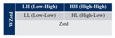
Furthermore, it identifies whether the autocorrelation is positive autocorrelation (quadrants I (HH) and III (LL)) or negative autocorrelation (quadrants II (LH) and IV (HL)). For clustering and dispersion patterns between locations, it can be presented with Moran's Scatterplot which shows the relationship between the observed value at a location (standardized) and the average observed value of the locations neighboring the location in question. Moran's Scetterplot is one way to interpret Moran's I statistics. Moran's Scetterplot is a tool to see the relationship between Zstd (the standardized observed value) and the local mean calculated from the weighting matrix WZstd (the local mean calculated from the spatial weighting matrix). For more details, see Figure 1.
Figure 1. Illustration of Zstd and WZstd values on Morans Scatterplot
Moran's Scatterplot is divided into 4 quadrants. Quadrant I (located at the top right) is called High-High (HH), indicating an area that has a high observation value surrounded by areas that have a high observation value. Quadrant II (located at the top left) is called Low-High (LH), indicating an area with low observations but surrounded by areas with high observation values. Quadrant III (located at the bottom left) is called Low-Low (LL), indicating an area with a low observation value and surrounded by areas with a low observation value. Quadrant IV (located at the bottom right) is called High-Low (HL), indicating an area with a high observation value surrounded by areas with a low observation value.
Moran Index is an index for identifying global autocorrelation spatial patterns and can be used to identify the tendency of centralization (concentration) or dispersion of a phenomenon which in this study is to identify the phenomenon of centralization of service facilities and activities that characterize centers of economic growth. Indications of growth center locations can be shown by the LISA method.
LISA is a measure of local spatial autocorrelation used to analyze the spatial relationship between an observation location and another observation location. LISA as a statistic can indicate significant clustering of spatial relationships of similar values around the region and the sum of the LISA values for the entire region is proportional to the Moran Index value. High spatial autocorrelation values show of clusters of high or low values (Table 1). LISA calculation is:
$I=Z i \sum_{i=1}^n W i j Z j$ (6)
where,
Zi and Zj = Standardization of data
Wij = Weighting between locations i and j
Based on Pravitasari et al. [22], LISA values allow for the computation of its similarity with neighbors and to test its significance. Table 2 shows four scenarios of LISA: 1) Locations with high values with similar neighbors (HH); 2) Locations with low values with similar neighbors (LL); 3) Locations with high values with low-value neighbors (HL); 4) Location with low value with high value neighbors (LH). Therefore, in this study, Moran's Index and LISA were applied to determine which areas in the prospective New Autonomous Region of North Sukabumi Regency could become centers of economic growth.
Table 2. Types of local spatial association
|
|
Spatially Lagged Geo-Referenced Variable (LX) |
||
|
High |
Low |
||
|
Geo-referenced variable (X) |
High |
Quadrant I: HH |
Quadrant IV: HL |
|
Low |
Quadrant II: LH |
Quadrant III: LL |
|
3.1 The hierarchy of regional development
Regional development aims to improve the welfare of the community and optimize the utilization of existing resources in a region. Some of the efforts made are by carrying out infrastructure development, increasing access to education and health services, and regional economic development [36]. One of the main objectives of regional development is to create an environment that supports sustainable economic growth and improves the quality of life of the local population and reduces the development gap between rural-urban areas [34]. One analysis of concentration in an area is by using the scalogram method. Scalogram analysis is built to determine the level of development of an area based on aspects of the availability of facilities and infrastructure, social aspects, economic aspects, area, and population accessibility to service centers [20].
As we know, the availability of facilities is not evenly distributed across villages. Therefore, this research was conducted to determine the hierarchy of villages in the prospective new autonomous region of North Sukabumi Regency. Identifying available facilities and identifying the ease of accessing facilities in an area can determine the hierarchy of growth centers. Infrastructure is a key variable because infrastructure service areas are the beginning of the development of growth center locations. Facilities or infrastructure play an important role in accelerating regional development and the community's economy, and also affect the improvement of community welfare and reducing inequality between regions [37].
The criteria for a region's growth center are that it is a fast-growing area, has strong interactions with the region behind it and has a leading sector. The regional unit that has the most complete type and number of public facilities will become the center or include the first hierarchy compared to other regions. Conversely, if an area has a low number of facilities then the area is a hinterland or back area of the regional unit that is the center of growth [35].
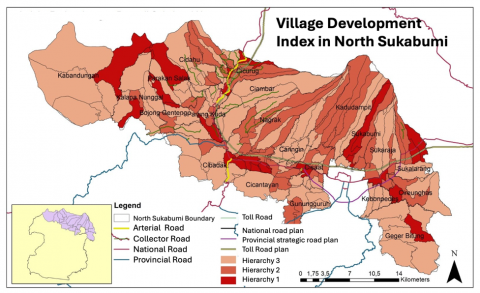
Based on the results of the scalogram analysis conducted on the prospective new autonomous region of North Sukabumi Regency where accessibility and facilities are the variables determining the hierarchy of economic growth center areas through the scalogram process, it was found that there are 22 villages are potential for the 1st hierarchy, 50 villages for the 2nd hierarchy and 91 villages for the 3rd hierarchy (Figure 2). 1st hierarchy is an area with a high level of development, 2nd hierarchy with a moderate level of development and 3rd hierarchy with a low level of development. The 22 villages included in 1st hierarchy are Batununggal Village in Cibadak Sub district, Benda Village in Cicurug Sub district, Cibadak Village in Cibadak Sub district, Cibatu Village in Cisaat Sub district, Cibolangkaler Village in Cisaat Sub district, Cicurug Village in Cicurug Sub district, Cimangkok Village in Sukalarang Sub district, Cipurut Village in Cireunghas Sub district, Gegerbitung Village in Gegerbitung Sub district, Kabandungan Village in Kabandungan Sub district, Kalapanunggal Village in Kalapanunggal Sub district, Karangtengah Village in Cibadak Sub district, Karawang Village in Sukabumi Sub district, Nyangkowek Village in Cicurug Sub district, Parakansalak Village in Parakansalak Sub district, Pasirhalang Village in Sukaraja Sub district, Perbawati Village in Sukabumi Sub district, Sukamanah Village in Cisaat Sub district, Sukatani Village in Parakansalak Sub district, Sundawenang Village in Parungkuda Sub district, Titisan Village in Sukalarang Sub district and Warnasari Village in Sukabumi Sub district.
Figure 2. Hierarchy of regional development of prospective for the new autonomous region of North Sukabumi Regency
3.2 Spatial linkage analysis of interregional development
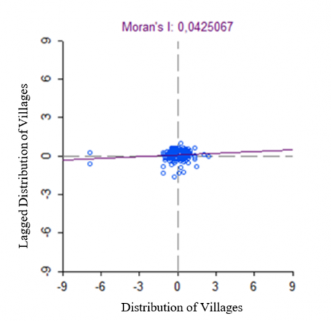
The results obtained from this research are in the form of information about villages in the prospective new autonomous region of North Sukabumi Regency that are correlated with one another. Based on accessibility and facility data, clustering patterns are formed in certain locations. The results of spatial autocorrelation calculation using Moran’s I method, parameters were found. In the first stage, the parameter analyzed is the value of Moran's I which is 0.0425067, the value is in the range 0 < I < 1, it is concluded that the autocorrelation that occurs is positive spatial autocorrelation. Positive autocorrelation indicates that adjacent locations have similar values and tend to be clustered. In the analysis, the provision of neighborliness based on villages is used, therefore, the groups in question are villages that are clustered based on similar characteristics.
After testing spatial autocorrelation globally using Moran's I, it is necessary to test locally to see which locations have spatial autocorrelation. In this research, local testing is done using LISA analysis. So that 2 (two) analysis results are obtained, namely:
The Moran's Scatterplot is composed of 2 (two) variables, namely Zstd (the standardized observed value) and WZstd (the local average value calculated from the spatial weighting matrix). In Figure 3, there are points scattered in 4 (four) different quadrants. The distribution of points is mostly around the slope, meaning that the standard deviation of the data used in this study is quite small, making it significant in showing spatial neighborliness.
Figure 3. Moran's Scatterplot of the distribution of areas in the prospective new autonomous region of North Sukabumi Regency that could become centers of economic growth
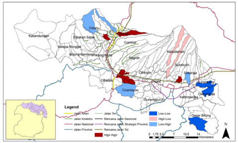
After knowing the areas in the prospective new autonomous region of North Sukabumi Regency that can become economic growth centers clustered in the quadrant of neighborliness, we can also know the spatial pattern of their distribution visualized in the map (Figure 4). The results of the distribution of values in the observations are as follows:
Figure 4. Clustering of spatial distribution patterns of areas in the prospective new autonomous region of North Sukabumi Regency that can become centers of economic growth
The area unit that has the most complete type and number of public facilities will be the center or the first in the hierarchy compared to other areas. Conversely, if an area has a low number of facilities then the area is a hinterland or back area of the regional unit that is the center of growth. Based on the results of the scalogram analysis where accessibility and facilities are the variables determining the hierarchy of the economic growth center area, it is found that there are 22 villages included in 1st hierarchy. Meanwhile, based on the LISA Cluster Map in Quadrant I (High-High), there are five villages, namely Karang Tengah, Balekambang, Nanggerang, Babakanpari and Sukajaya. These villages have the potential to become centers of high economic growth and are surrounded by other villages that have the potential to become centers of high economic growth as well.
The identification of growth and service centers is a very important step in designing a potential capital city in a new autonomous region. This is not only necessary to facilitate economic growth, but also to ensure efficient and quality public service delivery. As stated by Atkinson et al. [31] growth centers serve as focal points for the development of infrastructure and basic services, contributing to investment attraction as well as improving overall community welfare. Thus, a thorough identification of growth centers and public services not only supports systematic planning, but also helps in creating public trust in the new autonomous region.
Regional development hierarchy analysis is a crucial tool in the development planning process, as it provides assistance to local governments in recognizing existing growth patterns and prioritizing resource allocation to achieve sustainable development goals [27]. As stated by Li et al. [28] understanding the hierarchical structure of regions can provide an in-depth view of the relationship between growth centers and peripheral regions. This enables more effective policy design that is responsive to the needs of diverse communities. In addition, the analysis also serves to evaluate the level of public services available at each level of the hierarchy, providing a clear picture of areas that require further intervention [29]. In this context, the application of hierarchical analysis to prospective new autonomous regions can help reduce inequalities in regional development, so that the regions become better prepared to face various challenges that may arise in the future.
In addition to analyzing the hierarchy of regional development, the importance of analyzing the spatial linkages between regions in prospective new autonomous regions cannot be ignored. This analysis plays an important role in determining the dynamics of growth and interaction between various regions. These linkages cover various aspects, including accessibility and public service facilities that can support overall development. According to Yanbo et al. [30] spatial linkage mapping has the ability to identify resource distribution patterns and map potential synergies between regions, which in turn helps in more integrated and regional needs-based planning. In addition, this analysis also serves to anticipate challenges that may arise due to inequalities in development, thus enabling stakeholders to take strategic measures in creating inclusive and sustainable growth.
Overall, a comprehensive analysis of the hierarchy of regional development and spatial linkages between regions is essential for effective development planning. By understanding these structures and dynamics, local governments can formulate more appropriate strategies for allocating resources and responding to community needs. This approach will not only improve efficiency in resource use, but also contribute to more equitable and sustainable development across the region. Therefore, it is important for stakeholders to continuously evaluate and adjust existing development plans, in order to better face future challenges and ensure that each region, especially the economic growth centers in the new autonomous regions, can develop in an inclusive and sustainable manner.
Economic growth centers play an important role in regional development, especially in influencing the number of people who immigrate to the area. Regions that have growth centers, such as industrial, banking, or trading centers, tend to offer more job opportunities and improve the quality of life, which in turn attracts population migration from other regions. Regions with strong growth centers experience an increase in population as investment in the region increases. This population growth can directly strengthen the economic base by increasing demand for goods and services and creating opportunities for local businesses.
The Village Development Index (IDM) is also an important indicator in describing the progress of a region and its relationship with economic growth centers. The IDM covers various aspects, including infrastructure, education, and health services available in the village. Villages located close to economic growth centers tend to have a higher index, due to better accessibility to resources and services necessary for development. In addition, this makes these villages more potential to develop with the support that comes from the growth center, thus supporting the improvement of the quality of life of its people.
The status of the Regional Spatial Plan (RTRW) is another important factor in determining the direction of growth of both economic centers and population in a region. The RTRW not only serves as a guide for land use, but also creates a framework for the sustainable development of infrastructure, housing and land use. In this case, if the RTRW is designed with economic growth centers in mind, then space utilization will be more optimal, enabling balanced growth between urban and rural areas based on the potential of each region.
The linkages between these three factors also highlight the importance of the government's role in planning and managing regional development. The government needs to formulate a strategy that covers all elements from strengthening economic growth centers, improving the Village Development Index, to ensuring the status of RTRW is properly implemented. By doing this, it is expected to create an ecosystem that supports sustainable growth and reduces the development gap between regions. Synergistic efforts made can encourage inclusive economic growth and can be felt by the community at large.
Finally, it is important to compare the results of the Scalogram Analysis and Spatial Autocorrelation (Moran Index and LISA) that have been conducted with the population, IDM, and RTRW status as shown in Table 3. With a data-driven approach, development policies can be more adaptive and responsive to social, economic and environmental changes that occur in the community. As such, an in-depth understanding of these linkages will help build a strong foundation for the future development of economic growth centers in the New Autonomous Region of North Sukabumi Regency.
Table 3. The results of the Scalogram and LISA Cluster Map Analysis are compared with the existing conditions (Population, IDM Status and RTRW Status)
|
No. |
Alternative Economic Growth Center (Village) |
Sub District |
Total Population |
IDM Status |
RTRW Status |
Hierarchy (The Results of the Scalogram Analysis) |
Quadrant (The Results of LISA Cluster Map Analysis) |
|
1 |
Nang |
Cicurug |
6,808 |
Proceed |
Crop Area; Industry; Urban; park national |
2nd hierarchy |
Quadrant I (High-High) |
|
2 |
Babakan Pari |
Cidahu |
7,569 |
Independent |
Agricultural and residential areas |
2nd hierarchy |
Quadrant I (High-High) |
|
3 |
Sukajaya |
Sukabumi |
7,773 |
Proceed |
Agriculture (rice fields) and urban areas |
2nd hierarchy |
Quadrant I (High-High) |
|
4 |
Batu nunggal |
Cibadak |
8,132 |
Proceed |
Agricultural, industrial, residential, and forest areas production limited |
1st hierarchy |
Quadrant I (High-High) |
|
5 |
Karang tengah |
Cibadak |
17,372 |
Independent |
1st hierarchy |
Quadrant I (High-High) |
Since Indonesia adopted a decentralized system, there have been increasing proposals for the formation of new autonomous regions. However, careful analysis is needed to justify why a region should be designated as a new autonomous region. This analysis can provide a strong basis for supporting the formation of a new region. This study provides scientific evidence to support the case for granting autonomy to the prospective new autonomous region of North Sukabumi Regency.
To encourage balanced regional development, the expansion of Sukabumi Regency needs to be carried out. The results of the Scalogram Analysis and Spatial Autocorrelation (including the Moran Index and LISA) show that the area designated as the first hierarchy and located in Quadrant I (High-High) has considerable potential to become the center of economic growth in the Prospective New Autonomous Region of North Sukabumi Regency, namely Karang Tengah Village, Cibadak Sub District. This potential is supported by its status as an autonomous village. In addition, in accordance with the Sukabumi Regency Spatial Plan, Cibadak District functions as a Local Activity Center (PKL) that facilitates activities for the sub-district and surrounding areas, and is designated as a Regency Strategic Area (KSK) for economic development.
The discovery of an economic growth center in Karang Tengah Village, Cibadak Sub District, has important implications as an alternative capital for the Prospective New Autonomous Region of North Sukabumi Regency. The designation of this village can facilitate policy making in development planning, improve accessibility and public services, and develop infrastructure that supports regional economic growth. Thus, it is hoped that Karang Tengah Village can function as a center of government and a sustainable economic driver for the prospective New Autonomous Region of North Sukabumi Regency. Further research is needed to identify the potential dominant sectors that can become leading industries and to assess sustainable development scenarios.
[1] Daughters, R., Harper, L. (2007). Fiscal and political decentralization reforms. In The State of State Reform in Latin America. Stanford Economics and Finance, p. 299.
[2] Wicaksono, K. (2012). Desentralization problems and challenges in Indonesia. Jurnal Bina Praja, 94: 21-28. https://doi.org/10.21787/jbp.04.2012.21-28
[3] Azikin, A. (2018). Makna otonomi daerah dalam penyelenggaraan pemerintahan daerah pada era reformasi. Jurnal Manajemen Pemerintahan, 5(1): 35-41. https://core.ac.uk/download/pdf/481313152.pdf.
[4] Rauf, R. (2018). Asas Penyelenggaraan Pemerintahan Daerah. Nusa Media Yogyakarta.
[5] Duri, R., Rahmah, M. (2020). Asas penyelenggaraan pemerintahan daerah. Jurnal Kebijakan Pemerintahan, 3(1): 43-52. https://repository.uir.ac.id/1977/1/asas%20pemda%20rahyunir.pdf.
[6] Safira, L., Samudro, B.R., Mulyanto. (2023). Determination of the center for economic growth in Surakarta City, Indonesia: Geospatial approach. International Journal of Sustainable Development and Planning, 18(9): 2801-2810. https://doi.org/10.18280/ijsdp.180918
[7] Allen, F., Qian, J., Qian, M. (2005). Law, finance, and economic growth in China. Journal of Financial Economics, 77(1): 57-116. https://doi.org/10.1016/j.jfineco.2004.06.010
[8] Gakh, D. (2023). Societal patterns evolution model in development of economy, society, and environment. Journal of Research, Innovation and Technologies, 2(2): 142-161. https://doi.org/10.57017/jorit.v2.2(4).03
[9] Munaf, E., Amar, S., Idris. (2024). Infrastructure, investment, and environmental degradation: A study of economic development in West Sumatra. International Journal of Sustainable Development and Planning, 19(1): 309-316. https://doi.org/10.18280/ijsdp.190129
[10] Coe, N.M., Hess, M., Yeung, H.W., Dicken, P., Henderson, J. (2008). ‘Globalizing’ regional development: A global production networks perspective. In Economy. Routledge, p. 17.
[11] Widjajanti, K., Prihantini, F.N., Wijayanti, R. (2022). Sustainable development of business with canvas business model approach: Empirical study on MSMEs Batik Blora, Indonesia. International Journal of Sustainable Development and Planning, 17(3): 1025-1032. https://doi.org/10.18280/ijsdp.170334
[12] Leigh, N.G. (2024). Planning Local Economic Development: Theory and Practice. SAGE Publications.
[13] Falatehan, A.F., Sapanli, K., Putra, A.H. (2025). Sustainable development strategies for the west coastal mangrove ecosystem in West Bangka Regency: A socio-ecological systems approach. Challenges in Sustainability, 13(1): 67-77. https://doi.org/10.56578/cis130105
[14] Hariyanto, A., Juanda, B., Rustiadi, E., Mulatsih, S. (2024). The effect of village income on village expenditure: A case study of Belitung Regency. International Journal of Sustainable Development and Planning, 19(1): 131-138. https://doi.org/10.18280/ijsdp.190111
[15] Juanda, B. (2021). Pembentukan daerah otonomi baru (DOB): Tinjauan dari aspek keuangan. Bambangjuanda.com, 1-7. https://bambangjuanda.com/wp-content/uploads/2021/12/TADF_Policy_Brief_DOB_DJPK_2012.pdf.
[16] Rahma, H., Fauzi, A., Juanda, B., Widjojanto, B. (2019). Development of a composite measure of regional sustainable development in Indonesia. Sustainability, 11(20): 1-16. https://doi.org/10.3390/su11205861
[17] Fauzi, A. (2019). Teknik Analisis Keberlanjutan. PT Gramedia Pustaka Utama.
[18] Pravitasari, A.E., Rustiadi, E., Mulya, S.P., Widodo, C.E., Indraprahasta, G.S., Fuadina, L.N., Karyati, N.E., Murtadho, A. (2020). Measuring urban and regional sustainability performance in Java: A comparison study between 6 metropolitan areas. IOP Conference Series: Earth and Environmental Science, 556(1): 012004. https://doi.org/10.1088/1755-1315/556/1/012004
[19] Gong, J., Hu, Z., Chen, W., Liu, Y., Wang, J. (2018). Urban expansion dynamics and modes in metropolitan Guangzhou, China. Land Use Policy, 72: 100-109. https://doi.org/10.1016/j.landusepol.2017.12.025
[20] Pravitasari, A.E., Rustiadi, E., Priatama, R.A., Murtadho, A., Kurnia, A.A., Mulya, S.P., Saizen, I., Widodo, C.E., Wulandari, S. (2021). Spatiotemporal distribution patterns and local driving factors of regional development in Java. ISPRS International Journal of Geo-Information, 10(12): 812. https://doi.org/10.3390/ijgi10120812
[21] Hill, H. (2008). Globalization, inequality, and local‐level dynamics: Indonesia and the Philippines. Asian Economic Policy Review, 3(1): 42-61. https://doi.org/10.1111/j.1748-3131.2008.00087.x
[22] Pravitasari, A.E., Priatama, R.A., Mulya, S.P., Rustiadi, E., Murtadho, A., Kurnia, A.A., Saizen, I., Widodo, C.E. (2022). Local sustainability performance and its spatial interdependency in urbanizing Java Island: The case of Jakarta-Bandung mega urban region. Sustainability, 14(21): 13913. https://doi.org/10.3390/su142113913
[23] Kurnia, A.A., Rustiadi, E., Fauzi, A., Pravitasari, A.E., Ženka, J. (2023). Probing regional disparities and their characteristics in a suburb of a global south megacity: The case of Bekasi Regency, Jakarta Metropolitan Region. ISPRS International Journal of Geo-Information, 12(2): 32. https://doi.org/10.3390/ijgi12020032
[24] Firman, T., Fahmi, F.Z. (2017). The privatization of metropolitan Jakarta’s (Jabodetabek) urban fringes: The early stages of “post-suburbanization” in Indonesia. Journal of the American Planning Association, 83(1): 68-79. https://doi.org/10.1080/01944363.2016.1249010
[25] Firman, T. (2017). The urbanisation of Java, 2000–2010: Towards ‘the island of mega-urban regions’. Asian Population Studies, 13(1): 50-66. https://doi.org/10.1080/17441730.2016.1247587
[26] Rustiadi, E., Pravitasari, A.E., Setiawan, Y., Mulya, S.P., Pribadi, D.O., Tsutsumida, N. (2021). Impact of continuous Jakarta megacity urban expansion on the formation of the Jakarta-Bandung conurbation over the rice farm regions. Cities, 111: 103000. https://doi.org/10.1016/j.cities.2020.103000
[27] Rustiadi, E., Saefulhakim, S., Panuju, D.R. (2018). Perencanaan dan Pengembangan Wilayah. Yayasan Pustaka Obor Indonesia.
[28] Li, Y., Liao, C., Li, X., Guo, R. (2024). Understanding regional structure through spatial networks: A simulation optimization framework for exploring balanced development. Habitat International, 152: 103155. https://doi.org/10.1016/j.habitatint.2024.103155
[29] Yang, S. (2022). Analytic hierarchy process and its application in rural tourism service performance evaluation. Discrete Dynamics in Nature and Society. https://doi.org/10.1155/2022/5302588
[30] Yanbo, Q., Shilei, W., Yaya, T., Guanghui, J., Tao, Z., Liang, M. (2023). Territorial spatial planning for regional high-quality development: An analytical framework for the identification, mediation and transmission of potential land utilization conflicts in the Yellow River Delta. Land Use Policy, 125: 106462. https://doi.org/10.1016/j.landusepol.2022.106462
[31] Atkinson, R.D., Muro, M., Whiton, J. (2019). The case for growth centers: How to spread tech innovation across America. https://www2.itif.org/2019-growth-centers.pdf.
[32] Nusantara, A.W. (2014). The analyzes of scalogram, performance-importance and hierarchy process for grand strategy of the agro-industry development in Southeast Sulawesi. Humanities and Social Science Invention, 3(10): 40-45.
[33] Panuju, D.R., Rustiadi, E. (2013). Teknik analisis perencanaan pengembangan wilayah. Bogor: Lab. Pengembangan Wilayah, Departemen Ilmu Tanah dan Sumberdaya Lahan, Institut Pertanian Bogor.
[34] Putri, M.H.C., Putri, N.T. (2022). Local economic development sebagai upaya terwujudnya pembangunan berkelanjutan. Convergence: The Journal of Economic Development, 4(1): 41-53. https://doi.org/10.33369/convergencejep.v4i1.23018
[35] Rustiadi, E., Dardak, E.E. (2008). AGROPOLITAN (Strategi Pengembangan Pusat Pertumbuhan pada Kawasan Perdesaan). Library of IPB University. http://repository.ipb.ac.id/handle/123456789/74729.
[36] Kamuli, S., Wantu, S.M., Hamim, U., Djafar, L., Sahi, Y., Dahiba, H. (2023). Pemberdayaan berkelanjutan melalui pemanfaatan dana desa bagi masyarakat pesisir di Desa Momalia Kecamatan Posigadan Provinsi Sulawesi Utara. Jambura Journal Civic Education, 3(2): 279-293. https://doi.org/10.37905/jacedu.v3i2.21827
[37] Priyadi, U., Atmadji, E. (2017). Identifikasi pusat pertumbuhan dan wilayah hinterland di Provinsi Daerah Istimewa Yogyakarta. AJIE: ASEAN Journal of Innovation and Entrepreneurship, 2(2): 193-219. https://doi.org/10.20885/ajie.vol2.iss2.a