Abdul Wahid Hasyim*![]() | Bangun Muljo Sukojo
| Bangun Muljo Sukojo![]() | Erland Raziqin Fatahillah
| Erland Raziqin Fatahillah![]() | Intan Astritya Anggraini
| Intan Astritya Anggraini![]() | Andik Isdianto
| Andik Isdianto![]()
© 2025 The authors. This article is published by IIETA and is licensed under the CC BY 4.0 license (http://creativecommons.org/licenses/by/4.0/).
OPEN ACCESS
In response to the growing concern over urban heat islands and their impact on city environments and public health, this study investigates the dynamics of population density, land use, and land surface temperature (LST) in Malang City, Indonesia. Urban expansion has significantly altered the city's thermal profile, necessitating a comprehensive understanding of the interactions between human activities and environmental responses. Despite substantial research, there remains a gap in specific regional studies that correlate these factors with urban planning strategies to mitigate adverse effects. The objective of this research is to analyze how urban density and land use patterns influence LST, thereby informing sustainable urban development policies. Employing GIS-based spatial analysis and satellite imagery, this study maps the distribution of LST across varying densities and land use types in Malang City. Results indicate that areas with higher population densities and significant conversion of green spaces to build environments exhibit higher LSTs, particularly in the city center where the urban heat island effect is most pronounced. This study concludes that integrating green infrastructure and optimizing land use are crucial strategies to reduce LST and improve urban climate resilience. These findings provide actionable insights for urban planners and policymakers aiming to enhance the sustainability and livability of urban settings, thus contributing to broader efforts to address climate change impacts in rapidly urbanizing regions.
climate resilience, GIS mapping, green infrastructure planning, heat island quantification, spatial analysis, urban climate management, urban heat effects, vegetation impact on temperature
The rapid expansion of urban areas has led to various environmental issues, one of which is the increase in Land Surface Temperature (LST), a vital indicator of the ecological impacts of urbanization [1-3]. LST provides insights into how changes in land cover, human activities, and the intensity of development affect the physical environment of a region [4, 5]. Phenomena such as the urban heat island (UHI), where metropolitan areas tend to be warmer than their surrounding rural regions [6], have become a significant concern in many large cities, including those in Indonesia [7]. LST increases often correlate with high population density and poorly planned land-use patterns [8, 9]. Areas with large populations typically experience intense anthropogenic activities, such as energy consumption, transportation, and infrastructure development, all of which contribute to the accumulation of heat in the surrounding environment [10, 11]. Moreover, land transformation, particularly the conversion of green spaces into residential or commercial areas, exacerbates these impacts [12, 13]. Therefore, studying the interactions between LST, population density, and land use is highly relevant to support sustainable urban development, particularly in the context of cities in developing countries [14].
Understanding the interaction between these three elements is increasingly critical in urban sustainability. Uncontrolled urbanization transforms the physical landscape of cities and heightens environmental vulnerability to climate change [15]. Adequate green spaces, strategic land-use management, and equitable population distribution are vital in mitigating these adverse effects [16]. Analyzing these interactions provides a foundation for evidence-based spatial planning policies, fostering climate-friendly urban environments and enhancing the quality of life for urban residents [17]. Furthermore, such studies contribute valuable insights toward achieving SDGs, particularly Goal 11, which emphasizes inclusive, safe, resilient, and sustainable cities and communities [18].
Despite the increasing number of urban thermal studies globally, region-specific investigations at the intra-city level remain limited, particularly in fast-growing medium-sized cities in Southeast Asia. The present study addresses this gap by focusing on the spatial dynamics of LST in relation to population density and land use in Malang City, Indonesia.
Malang City, the second most populous city in East Java Province, faces similar challenges. As a hub of education and economic activity, Malang City has undergone rapid urbanization, with significant population growth in recent decades [19]. The conversion of green spaces into residential, commercial, and infrastructure zones has drastically altered the city's environmental characteristics [20]. This is evident in the city center, where high population density is coupled with a scarcity of green spaces, while peripheral areas face increasing development pressure. The impacts of these changes are not confined to the physical environment but extend to social aspects, such as rising ambient temperatures that affect living comfort and public health [21]. Additionally, spatial disparities between the city center and peripheral areas create inequities in the distribution of environmental risks and quality of life [22].
Malang City was selected as the study area due to its distinct spatial heterogeneity, combining historical urban cores, rapidly urbanizing subcenters, and peri-urban zones characterized by agricultural or vegetated land. This diversity allows for nuanced spatial comparisons of urban thermal profiles across differing land use typologies and population densities. The spatial heterogeneity of its urban form allows for a detailed analysis of how population distribution and land use intensity influence surface temperature at the sub-district (kelurahan) level. The study considers urban expansion patterns over time and the degree to which built-up intensity contributes to urban warming [23]. While the primary analysis is based on static data for 2024, the study also contextualizes recent trends using supplementary historical imagery from 2014 to 2024 to indicate long-term thermal change trajectories [24].
This study hypothesizes that increasing population density and conversion of green open spaces into commercial or residential areas will increase LSTs in residential areas of Malang City. The unit of spatial analysis is defined at the sub-district level, using data with a spatial resolution of 30 meters for LST and land use, and adjusted population density data from Central Bureau of Statistics. This research will describe spatial patterns and factors influencing surface temperature increases across residential zones by employing a spatial analysis approach based on data from LST maps, population density maps, land-use maps, and spatial planning documents. It also seeks to evaluate how land-use characteristics and population distribution contribute to LST changes and propose strategic measures to mitigate their adverse effects. Thus, this study enriches the literature on the interaction between urbanization and the environment and provides practical recommendations that can be implemented in sustainable urban spatial planning and policymaking, related to UHI mitigation strategies and more effective land use management to improve the quality of life, especially in Malang City.
2.1 Study area
Malang City, located in East Java Province, Indonesia, is one of the region's most prominent urban centers, known for its role as an educational hub and a growing economic center. Covering an area of approximately 111.077 km2, Malang is divided into five districts: Klojen, Blimbing, Lowokwaru, Sukun, and Kedungkandang. According to the Central Bureau of Statistics, Malang City had a population of approximately 847,182 in 2024, with a high population density concentrated in central districts such as Klojen, with 10,646 people/km2. The increasing population density, particularly in central areas, has also heightened the need for sustainable urban planning to balance development and livability. This rapid population growth and urbanization have placed significant pressure on land resources, leading to substantial changes in land use patterns, including the conversion of green spaces into residential and commercial zones [25].
The city's geographical location, surrounded by mountainous areas, contributes to a relatively cool climate compared to other urban areas in Indonesia. However, the impacts of urbanization, such as increased surface temperatures and reduced green space, have raised concerns about sustainability and environmental quality. Malang's spatial dynamics are influenced by its position as part of the broader Malang Raya metropolitan area, encompassing the adjacent regions of Batu City and Malang Regency [26].
This spatial structure results in diverse urban morphologies, from heritage zones and compact settlements in the city center to peri-urban agricultural lands, making it ideal for examining urban thermal variations across land use types and population densities.
2.2 Data collection
The data utilized in this study were collected through a combination of primary and secondary sources to ensure a comprehensive analysis of the interaction between LST, population density, and land use in Malang City. Primary data for LST and land use were obtained through remote sensing analysis [27], while secondary data for population density were obtained from Central Bureau of Statistics.
LST data were derived from Landsat 8 OLI/TIRS satellite imagery, which provides thermal infrared data with a spatial resolution of 100 meters, resampled to 30 meters [28]. LST values were extracted using the Single Channel Method, incorporating radiometric calibration, atmospheric correction, and land surface emissivity estimation, following USGS standard processing steps. This dataset was processed to calculate surface temperature using standard algorithms, ensuring accuracy in representing the thermal characteristics of the study area.
Population density data were sourced from the Malang City Statistical Agency, which provides detailed demographic information at the sub-district level, reflecting population distribution and density across the city. To enhance spatial resolution, dasymetric mapping techniques were used to redistribute population counts based on land use characteristics, refining the spatial precision of density estimates to match the thermal data resolution.
Land use data were obtained from Sentinel-2 10-Meter Land Use/Land Cover classification, which offers high-resolution satellite imagery suitable for analyzing land cover types, including green spaces, built-up areas, and other land-use categories [29]. The classification process involved supervised techniques to ensure accurate categorization of urban and non-urban areas within the city. The Maximum Likelihood Classification (MLC) method was employed, and its accuracy was assessed using a confusion matrix, yielding an overall accuracy of 87% and a Kappa coefficient of 0.83 [30].
This combination of remote sensing data and demographic statistics allows for a robust spatial analysis of the interactions among the variables of interest. Integrating satellite imagery and official statistical data provides the foundation for identifying spatial patterns, understanding urbanization impacts, and proposing strategic interventions to enhance urban sustainability in Malang City.
2.3 Population density
Population density is a fundamental demographic measure that quantifies the number of people living in a given area, typically expressed as individuals per square kilometers [31]. It plays a critical role in urban studies, as it is closely linked to various aspects of urbanization, including land use patterns, infrastructure development, and environmental impacts. Regions with high population density frequently encounter serious issues such as congestion, restricted access to basic services, and heightened strain on urban infrastructure [32]. Moreover, areas with high population density tend to exhibit more intense human activities, such as transportation, energy consumption, and waste generation, which can exacerbate environmental issues like air pollution, noise, and heat islands [33].
Studies have demonstrated that population density is a crucial determinant of urban form and spatial organization [34]. In cities with high population density, land is often used more intensively, leading to reduced green spaces and increased built-up areas. This process contributes to the "urban heat island" effect, where dense urban areas experience higher temperatures than their rural counterparts due to the concentration of buildings, roads, and other heat-absorbing surfaces [35]. Additionally, high population density is associated with increased social interaction, economic activities, and resource consumption, further affecting urban environments' livability and sustainability [36].
The relationship between population density and LST is particularly significant in rapidly urbanizing areas [37]. Research has shown that areas with higher population densities often experience increased LST, driven by higher energy use, reduced vegetative cover, and increased impervious surfaces. In this study, population density serves as an explanatory variable that interacts with land use configuration in shaping urban thermal patterns. Therefore, understanding population density patterns is essential for assessing the thermal characteristics of urban areas and addressing the associated challenges, such as mitigating the UHI effect and improving urban resilience [38].
2.4 Land use
Land use refers to the various human activities or the economic function of a particular land area, such as residential, commercial, industrial, agricultural, and recreational purposes [39]. Land use significantly impacts environmental quality, resource distribution, and urban sustainability. Land use patterns influence factors such as energy consumption, waste generation, and environmental degradation, with metropolitan areas characterized by dense built-up structures often leading to higher resource consumption and environmental pressures [40]. The relationship between land use and environmental outcomes, including LST, has been extensively studied, with research indicating that urbanization tends to increase LST due to the expansion of impervious surfaces like roads, buildings, and parking lots, which absorb and retain heat [41]. In cities like Malang, rapid urbanization necessitates a balance between development and environmental conservation to prevent excessive LST increases and maintain ecological stability. Collaborative urban planning that integrates sustainable land use practices is crucial to achieving this balance.
The conversion of natural landscapes to urban environments typically results in a reduction in green spaces, such as forests, wetlands, and agricultural land, which are critical for regulating temperature and enhancing biodiversity [42]. Green areas play a crucial role in mitigating heat through evapotranspiration and shading. In contrast, built-up areas often contribute to the UHI effect, where urban areas experience higher temperatures than their rural counterparts. Within Malang, spatial analysis reveals that residential and commercial zones exhibit the highest LST, especially in core urban areas with minimal vegetation. For example, residential and commercial land uses, with their compacted infrastructure and high energy demand, can lead to higher LST compared to agricultural or recreational spaces, which tend to have more vegetation and open areas that provide cooling effects [43].
The study of land use is essential for understanding the spatial distribution of environmental conditions, such as temperature, in urban settings. Researchers have utilized remote sensing technologies to analyze land use and its effects on urban heat, leveraging satellite data to classify land cover and monitor changes in land use over time [44]. In rapidly growing cities, converting agricultural land to urban areas exacerbates environmental challenges, including higher temperatures and poorer air quality. In Malang, understanding land use dynamics is essential for assessing urbanization's impact on the city's thermal environment and identifying strategies to improve the urban climate through better planning and increased green spaces.
2.5 LST
LST is a critical environmental variable that reflects the thermal state of the Earth's surface [45]. It is a crucial indicator of energy exchange processes between the land surface and the atmosphere, influenced by land cover, land use, and human activities. LST is widely used in urban studies to analyze phenomena like the UHI effect, which occurs when urban areas exhibit higher temperatures than surrounding rural regions due to anthropogenic heat sources and modified land surfaces [46]. Studies have shown that impervious surfaces, such as roads and buildings, tend to absorb and retain heat, significantly increasing LST in urban environments [47].
The assessment of LST using remote sensing techniques has become a standard approach, leveraging satellite data from sensors such as Landsat, MODIS, and Sentinel [48]. For instance, Landsat 8 OLI/TIRS provides high-resolution thermal infrared imagery that enables detailed spatial analysis of surface temperature patterns. Algorithms such as the radiative transfer equation (RTE) and split-window method are commonly applied to derive LST from satellite data, ensuring an accurate representation of thermal variations across different land-cover types [49]. In this study, LST was derived from Band 10 of the TIRS sensor using the Single Channel Algorithm, with corrections applied for atmospheric effects, land surface emissivity, and sensor calibration parameters.
Numerous studies have established strong correlations between LST and urbanization, population density, and vegetation cover [50]. High population density areas often exhibit elevated LST due to increased energy consumption, reduced green spaces, and the dominance of built-up surfaces. Conversely, vegetation acts as a cooling agent, reducing LST through evapotranspiration and shading [51]. These findings underscore the importance of integrating LST analysis into urban planning to mitigate the adverse impacts of UHIs and enhance urban sustainability.
In developing cities like Malang, Indonesia, analyzing LST provides valuable insights into the thermal impacts of rapid urbanization. By understanding the spatial distribution of LST and its drivers, policymakers can design evidence-based interventions, such as expanding urban green spaces and optimizing land-use patterns, to improve urban resilience and environmental quality [52].
2.6 Relationship between LST, land use, and population density
Linear regression methods have been commonly used in many studies that examine the relationship between LST and urban landscapes. However, because of seasonal variations in land cover data, intricate landscape architecture, and variety in urban morphology, regression methods' correlation results may not be linear. In this case, linear regression models can help analyze trends and provide an overview of the relationship between LST and land cover.
This study used simple linear regression analysis to calculate the influence between population density and LST values. The method used is simple linear regression with the average value of LST per village as the Y variable and the level of population density per village as the X variable. Meanwhile, the multiple linear regression method was used to analyze the influence between land use classification and LST values. The variables used are the average LST value per grid as the Y variable and the area value of each land use type per grid as the X variable. The grid-based approach enhances spatial precision and allows the comparison of mixed land use combinations. The grid is a square measuring 800 m × 800 m with a total sample size of 111 grids. The following is the equation model of simple and multiple linear regression.
Y = a0 + a1.X1 (simple linear regression)
Y = a0 + a1.X1 + a2.X2 + … + an.Xn (multiple linear regression)
Information:
Y = Dependent variable value prediction
a1 = First independent variable
a2 = Second independent variable
an = n independent variable
a0 = Constant
X1 = First independent variable coefficient
X2 = Second independent variable coefficient
Xn = n independent variable coefficient
3.1 Population density and its impacts on urban development in Malang City
Population density is a crucial demographic variable that influences many aspects of urbanization, including land use, infrastructure, and environmental conditions [53]. In Malang City, the distribution of population density across different sub-districts plays a significant role in shaping the local thermal environment. As population density increases, so do the challenges associated with managing urban growth, such as overcrowding, pressure on infrastructure, and heightened environmental impacts. The population density data across Malang City reveals significant variations that closely correlate with land use distribution and LST patterns.
Figure 1. Population density of Malang City 2024
Based on the map in Figure 1 of the Population Density of Malang City 2024, sub-districts such as Kotalama (35,954 people per square kilometer), Mergosono (33,120 people per square kilometer), Tanjungrejo (29,601 people per square kilometer), and Jodipan (26,090 people per square kilometer) exhibit the highest population densities in the city. These sub-districts are located in strategic transitional zones between the historic city center and emerging middle- to upper-class residential and commercial developments. Their high density can be attributed to a combination of historical settlement patterns, limited land availability, and their proximity to transportation hubs, traditional markets, and employment centers. Moreover, areas like Kotalama and Jodipan have long functioned as economically accessible housing areas with dense kampung structures, attracting low- to middle-income residents who rely on walkability and public transport access. The pressure of urban infill, coupled with the lack of vertical housing alternatives, has intensified land use in these areas, resulting in compact, high-density neighborhoods that reflect both social vulnerability and spatial efficiency.
In contrast to Malang City's densely populated sub-district, sub-districts such as Wonokoyo (1,425 people per square kilometer), Tlogowaru (1,824), Buring (3,012), Cemorokandang (3,089), and Tasikmadu (3,153) exhibit significantly lower population densities. These areas, situated on the city's periphery, align with the outer residential and commuter zones described in Burgess's Concentric Zone Model (1924), where land is more affordable, and development is less intensive. Their lower densities can be attributed to several factors: the prevalence of agricultural land use, limited urban infrastructure, and greater distances from the central business district, which reduce their attractiveness for high-density settlement. Additionally, these sub-districts often lack the economic and social amenities found in more central areas, further contributing to their lower population densities. This spatial distribution reflects the city's expansion patterns and underscores the influence of urban planning and socioeconomic factors on population density. This spatial pattern demonstrates that population density, while not the sole determinant, significantly interacts with urban form to shape LST distribution across the city.
As discussed in the theoretical, population density is a critical factor influencing the urban environment. High population density areas often face challenges such as overcrowding, limited access to essential services, and excessive pressure on urban infrastructure [32]. These challenges are compounded by more intense human activities, such as energy consumption and transportation, which contribute to environmental issues like air pollution and increased heat retention, ultimately raising LST in these areas [33].
Studies, such as those by Mohajerani, show that higher population density leads to more intensive land use, which reduces green spaces and increases the extent of impervious surfaces like roads, buildings, and parking lots [35]. This directly contributes to the UHI effect, where densely populated urban areas experience higher temperatures than their rural counterparts. This phenomenon is evident in Malang City, especially in Kotalama Sub-district and Mergosono Sub-district, where high population densities coincide with significant built-up areas, further exacerbating LST.
The findings support the conclusion of Apriana, who found that population density is a crucial determinant of LST in rapidly urbanizing cities [37]. In Malang, high-density areas are associated with greater energy use, reduced vegetative cover, and increased impervious surfaces, contributing to higher temperatures. Understanding these dynamics is crucial for addressing the challenges of UHIs and developing sustainable urban planning strategies to improve the city's resilience to rising temperatures. Therefore, managing population density, optimizing land use, and expanding green spaces are essential to mitigating the adverse effects of urbanization and enhancing the overall livability of Malang.
3.2 Land use distribution and its environmental impacts in Malang City
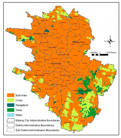
Land use significantly shapes the urban environment, particularly in rapidly urbanizing cities like Malang. The distribution and types of land use, ranging from residential and commercial areas to green spaces and agricultural zones, directly influence environmental quality, including factors like LST. In this section, we analyze the land use distribution across Malang City's sub-districts, focusing on how different land use classifications contribute to the UHI effect. The land use distribution across Malang City’s sub-districts clearly impacts the local LST, with built-up areas contributing significantly to higher temperatures.
Based on the map in Figure 2 about the Land Use of Malang City 2024, in Malang City, land use patterns reveal a stark contrast between central and peripheral sub-districts, particularly in terms of built-up area coverage. Many sub-districts in the city center exhibit nearly 100% built-up areas, reflecting intense urban development driven by high demand for residential, commercial, and institutional land uses. This high-density urban fabric is a result of limited land availability and the centralization of economic, educational, and governmental functions. That high-density urban fabric is evident in sub-districts such as Kotalama and Mergosono, where the total absence of vegetated land. Combined with the dominance of impervious surfaces like roads, buildings, and paved courtyards, significantly contributes to elevated LST. These areas have limited tree cover and minimal agricultural land, resulting in insufficient natural cooling and a heightened UHI effect.
Figure 2. Land use of Malang City 2024
In contrast, sub-districts located on the urban fringe, such as Tlogowaru, Wonokoyo, and Buring, still maintain a more balanced land use composition, with substantial portions of agricultural land, open spaces, and low-density housing. These areas function as transitional zones between urban and rural environments, offering greater spatial flexibility and potential for future development. This vegetation serves as a buffer against excessive heat accumulation and demonstrates the moderating role of green infrastructure. The disparity in land use intensification between core and peripheral areas highlights the spatial consequences of unregulated urban expansion and calls for integrated land use planning to ensure sustainable and equitable urban growth across Malang. The contrast in thermal characteristics between urban core and peripheral districts underscores the critical role of spatial planning in managing urban heat and ensuring environmental sustainability. Without strategic interventions, ongoing urbanization in the city’s fringe areas may lead to further land cover change, thereby eroding their current climatic advantages.
However, increasing urbanization may still challenge this balance, making it imperative to prioritize sustainable land use planning. Enhancing green infrastructure and promoting mixed-use developments can help alleviate the thermal impact while fostering resilient urban environments.
The data presented here aligns with existing research on the relationship between land use and environmental outcomes, particularly the impact on LST. According to Pratama, land use significantly influences ecological quality and resource distribution [39]. In rapidly urbanizing cities like Malang, converting green spaces into built-up areas contributes to higher resource consumption and environmental pressures. This trend is evident in Kotalama Sub-district and Mergosono Sub-district, where large built-up areas dominate, leading to the potential for increased LST due to the concentration of impervious surfaces such as roads and buildings.
As noted by Chotchaiwong and Setiawan, urbanization tends to raise LST, particularly in areas with dense infrastructure, as these surfaces absorb and retain heat, exacerbating the UHI effect [41, 43]. On the other hand, vegetated areas, such as the trees and crops found in Wonokoyo Sub-district, Tlowogaru Sub-district, and Buring Sub-district, offer cooling effects through processes like evapotranspiration and shading, reducing the impact of urbanization on local temperatures. This aligns with Paudel, who highlights that the reduction of green spaces, especially the conversion to build environments, exacerbates temperature increases and reduces biodiversity [42].
In Malang, converting agricultural land and green spaces into residential and commercial zones is a significant factor driving higher surface temperatures, as urban heat is amplified in areas with inadequate green infrastructure. According to Hasyim, monitoring land use and understanding its thermal effects is crucial for developing sustainable urban planning strategies [44]. By promoting the expansion of green spaces and managing urban sprawl through zoning regulations that preserve natural areas, Malang can mitigate the adverse effects of UHIs and promote a more resilient urban environment. Therefore, balancing built-up areas with sufficient green spaces is essential for maintaining an environmentally sustainable urban climate.
3.3 LST variations and influencing factors in Malang City
LST is a critical environmental variable that offers valuable insights into the thermal state of a region's surface. In urban environments like Malang City, LST plays a significant role in identifying areas affected by the UHI effect, where urbanized areas tend to be significantly warmer than surrounding non-urbanized zones. Understanding the spatial patterns of LST and how it interacts with factors like population density and land use is crucial for assessing the environmental impacts of urbanization. This section will analyze the LST patterns across Malang City’s Sub-districts, integrating the spatial variations observed in the heat maps with data from population density and land use to provide a comprehensive understanding of the thermal dynamics in the city. Addressing LST through targeted urban planning, such as increasing green infrastructure and promoting energy-efficient building designs, will mitigate the UHI effect. Furthermore, adaptive strategies like enhancing urban greenery corridors and rooftop gardens can reduce temperature across high-density zones. These approaches will minimize thermal stress and improve overall urban resilience and livability.
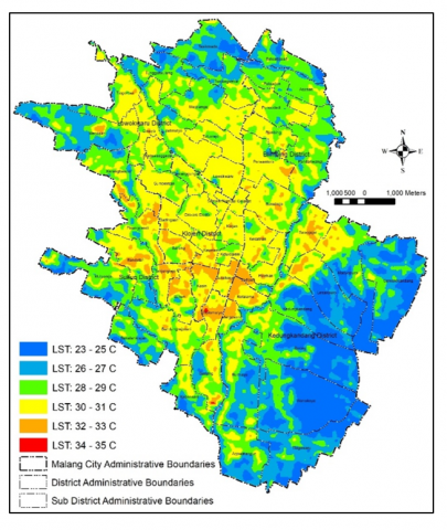
Based on the map in Figure 3, the LST distribution in Malang City for the year 2024 reveals distinct thermal patterns across its various sub-districts. Central areas, particularly Klojen sub-districts, Kiduldalem sub-districts, and Kauman sub-districts, exhibit elevated temperatures ranging from 30℃ to 33℃, clearly indicating the presence of a pronounced UHI effect. This condition is closely associated with a high concentration of built-up areas, dense population, and minimal green open space. These inner-city sub-districts are characterized by narrow alleys, traditional markets, and continuous impervious surfaces, such as asphalt roads, rooftops, and concrete walls, that absorb and retain solar radiation during the day and slowly release it at night, thereby sustaining higher ambient temperatures. The urban fabric in these areas lacks significant vegetation, which plays a vital role in regulating surface temperature through evapotranspiration.
Figure 3. The LST of Malang City 2024
Additionally, nearby sub-districts such as Kotalama and Mergosono also show even higher LST values, reaching between 30℃ and 35℃. This is largely due to the dominance of impervious surfaces and the absence of functional green infrastructure. These areas, with nearly 100% built-up coverage and very limited vegetation, are unable to buffer daytime heating, resulting in intensified thermal conditions. This aligns with findings from previous studies, which indicate that built-up density, building geometry, and lack of vegetation significantly influence the urban thermal landscape.
In contrast, peripheral sub-districts such as Wonokoyo, Tlogowaru, and Buring display noticeably lower LST values, particularly in areas dominated by agricultural land and vegetative cover. These regions benefit from the cooling effect of trees and crops, which lower surface temperatures through evapotranspiration, shading, and higher surface albedo. Furthermore, the spatial openness and lower building densities in these fringe areas facilitate better air circulation and reduce heat accumulation. These findings are consistent with urban climatology literature, which suggests that vegetated land cover has a mitigating effect on LST and helps to counterbalance the urban heat load generated in city centers. Consequently, these peripheral zones represent crucial buffers that support microclimate regulation and should be prioritized in sustainable land use planning.
Additionally, north area of Malang City shows a mixed pattern, with specific areas experiencing moderate temperatures (ranging from 27℃ to 30℃). Although it contains built-up areas and some green spaces, the extensive urbanization, including regions like Tulungsekar and Tulusrejo, results in a noticeable temperature increase. Trees in some parts of the district help moderate the temperature, but overall, the high density of built-up areas contributes to higher LST. In the future, integrating more green spaces into these high-temperature districts could be a crucial step in minimizing LST disparities. Enhanced collaboration between urban planners and environmental experts will also be necessary to implement sustainable urban cooling strategies effectively.
LST is a crucial indicator of thermal dynamics within urban environments, reflecting the interaction between the Earth's surface and the atmosphere. As discussed by Li and Vujovic, LST is heavily influenced by land cover, land use, and human activities [45, 47]. In Malang City, the data support the theory that impervious surfaces, such as roads and buildings, significantly increase LST. These surfaces absorb and retain heat, contributing to the UHI effect, particularly in densely urbanized districts like Klojen and Kotalama. The lack of vegetation in these areas further exacerbates this effect, leading to higher temperatures compared to surrounding regions [46].
The presence of vegetation in more suburban sub-districts, such as Wonokoyo, Tlogowaru, and Buring helps moderate surface temperatures by providing shading and promoting evapotranspiration, which reduces heat absorption from the sun [51]. This aligns with the findings of Maishella, who emphasized that green spaces play a crucial role in mitigating the UHI effect by lowering LST [50]. Conversely, high-density urban areas with limited green space lead to increased energy consumption, heat retention, and air pollution, which further elevate LST, as discussed by Mohajerani and Assayuti [33, 35].
In Malang’s rapid urbanization context, understanding the distribution of LST is crucial for urban planning and environmental sustainability. As Surya suggests, expanding urban green spaces, managing land use, and reducing impervious surfaces can mitigate the adverse impacts of urbanization and improve overall urban resilience [52]. By prioritizing the integration of green spaces and climate-sensitive planning, policymakers can help reduce the UHI effect, enhance the quality of life for residents, and promote sustainable urban development. Thus, the LST data serves as a vital tool for evaluating the effectiveness of these strategies in Malang City.
3.4 Interaction between population density, land use, and LST: Implications for sustainable urban planning in Malang City
The interaction between LST, population density, and land use in Malang City offers insights into the spatial dynamics of urbanization. The LST map reveals temperature variations ranging from 23℃ to 35℃, with higher temperatures (34-35℃) concentrated in densely populated urban areas, particularly in the city center, as red zones indicate. Conversely, lower temperatures (23-25℃) are observed in areas with significant vegetation or open spaces, predominantly in the outskirts. This pattern highlights the impact of the UHI phenomenon, where urbanized regions exhibit elevated surface temperatures due to reduced vegetation and increased human activities [52]. These thermal patterns underscore the urgency for adaptive urban strategies, particularly in high-density areas, to reduce heat retention and enhance urban cooling.
Overlay analysis confirms the spatial congruence of LST hotspots, dense population clusters, and built-up zones, reinforcing the need for multi-layered planning responses. Implementing urban forests and green roofs can significantly mitigate LST, improving thermal comfort and air quality.
The population density map complements this observation by showing that the highest densities, reaching 35,954 people per square kilometer, are found in central districts such as Klojen. These high-density zones coincide with areas of elevated LST, suggesting that densely populated settlements contribute significantly to temperature increases due to intensified land use and reduced green spaces [52]. In contrast, areas with lower population densities (as low as 1,425 people per square kilometer) are primarily located in suburban or rural regions, where temperatures are generally cooler due to the prevalence of vegetation.
The land use map (Figure 2) further underscores this relationship, demonstrating that built-up areas (represented in orange) dominate the city center and densely populated regions, while vegetation (green shades) and agricultural land are more common in peripheral zones. Areas with high construction density and minimal vegetation cover are associated with higher LST (Figure 3), while regions with more green spaces tend to have lower temperatures [52]. The spatial correlation among the three maps reveals that urbanization, characterized by increased population density and expansion of built-up areas, directly influences LST by replacing natural land cover with impervious surfaces, which retain heat. Therefore, balancing urban development with strategic green space allocation is vital in managing LST and maintaining a livable urban environment, particularly as Malang expands.
The interaction of LST, population density, and land use in Malang City highlights the environmental challenges posed by urbanization. High-density urban areas exhibit higher LST due to reduced vegetation and increased anthropogenic heat sources, while peripheral regions benefit from the cooling effects of natural land cover. These findings emphasize the importance of sustainable urban planning practices, such as preserving green spaces and controlling population density, to mitigate the adverse effects of UHIs and promote environmental resilience. Urban planning strategies that incorporate green infrastructure can significantly reduce LST and improve thermal comfort for residents [52].
3.5 The relationship between LST and population density: Implications for urban health and planning
To strengthen the description of the relationship between LST, land use, and population density as previously described, statistical analysis in the form of linear regression method was also used to statistically calculate the influence of the variables of land use type and population density on the condition of LST distribution in Malang City in 2024. The equation model of the influence between LST and population density in Malang City is calculated using a simple linear regression method with the research unit in the form of sub-district in Malang City, which are 57 sub-districts. This approach allows for a quantitative assessment of how land use patterns and population densities contribute to temperature fluctuations, providing a clearer understanding of urban thermal dynamics. This analysis enhances the empirical validity of observed spatial correlations by offering measurable statistical relationships. The following Table 1 is the resulting equation model.
Table 1. Coefficients 1
|
|
Model |
Unstandardized Coefficients |
Sig. |
|
|
B |
Std. Error |
|||
|
1 |
(Constant) |
27.705 |
.275 |
.000 |
|
|
X |
.132 |
.022 |
.000 |
Y (LST) = 27.705 + 0.132 X (population density)
From the output (Table 1) above, it is known that the significant value (Sig.) of 0.000 is smaller than the probability <0.05, so it can be interpreted that there is a substantial influence of variable x in the form of population density on variable y in the form of LST. However, the model has an adjusted R Square value of 39.4%, including in the moderate R-Square value category, which shows that the effect of population density (X) on the LST value (Y) in this model is 39.4%. In comparison, 60.6% of LST is influenced by other variables that are not studied. This percentage is low, possibly due to the inadequate number of samples, because it uses a research unit in the form of a sub-district. In addition, LST is a very complex study, and many factors influence the increase or decrease in LST, including land use changes, reduced vegetation cover, and increased anthropogenic heat emissions.
Referring to the equation model above, it can be concluded that population density (X) positively affects LST (Y) with a total effect of 39.4%. This positive effect defines that the increasing population density in an area will affect the increase in the LST value in that area. The coefficient value of 0.132 implies that for every unit increase in population density, LST rises by 0.132℃, highlighting a moderate but notable thermal impact of urban concentration. So, this model will explain simply the effect of one factor, namely population density, on LST due to the complexity of studies related to LST.
Research indicates a strong positive correlation between population density and LST, particularly in densely populated urban centers. As population density increases, the demand for housing and infrastructure leads to the conversion of green spaces into built environments, which in turn raises surface temperatures [52]. For instance, studies have shown that urban areas with high road density and significant built-up land exhibit higher concentrations of pollutants and elevated LST, primarily due to emissions from traffic and industrial activities [52]. This correlation underscores the need for urban planners to consider population density when assessing thermal environments in cities.
The implications of these findings extend beyond mere temperature fluctuations; they also encompass significant public health concerns. Elevated LST is associated with increased heat-related morbidity and mortality, particularly among vulnerable populations such as the elderly and those with pre-existing health conditions [52]. Urban planners must therefore prioritize strategies that address both population density and LST to create healthier urban environments. This includes promoting sustainable land use practices that preserve and enhance green spaces, thereby reducing the thermal impact of urbanization [52].
The intricate relationship between LST and population density has profound implications for urban health and planning. As urban areas continue to grow, understanding the factors that contribute to elevated temperatures is essential for developing effective strategies to mitigate the UHI effect and protect public health. Urban resilience planning should integrate demographic data, spatial thermal maps, and land use zoning to formulate adaptive solutions. Integrating green infrastructure and sustainable land use practices into urban planning can significantly improve thermal comfort and overall quality of life in densely populated cities.
3.6 The relationship between LST and land use: Environmental impacts and urban sustainability
A statistical analysis was conducted to clarify the relationship between LST and land use classification and determine the magnitude of the influence of these variables. The method used is the multiple linear regression method with the LST value as the Y variable and the land use classification as the X variable. The land use classifications included in the equation calculation are built area, crops, and trees. Water and rangeland land uses are not included because the area of the two land uses is shallow, so there is a significant imbalance when calculated together with the other three variables, which will interfere with the output in the form of the final model. This selective inclusion of variables ensures that the model accurately reflects LST's most influential land use categories, leading to more reliable and interpretable results. The unit used in this analysis is a grid measuring 800 m × 800 m with a sample of 111 grids. Table 2 shows the resulting equation model.
Table 2. Coefficients 2
|
|
Model |
Unstandardized Coefficients |
Sig. |
|
|
B |
Std. Error |
|||
|
1 |
(Constant) |
26.778 |
1.164 |
.000 |
|
|
X1 (Built Area) |
.044 |
.018 |
.020 |
|
|
X2 (Crops) |
-.051 |
.018 |
.007 |
|
|
X3 (Trees) |
-.065 |
.020 |
.001 |
Y (LST) = 26.778 + 0.044 X1 – 0.051 X2 – 0.065 X3
Based on the model output (Table 2), it is known that the significance value (Sig.) of the three variables is X <0.05, which means that the three variables in the form of land use types have a significant partial effect on the LST variable. The three types of land use also have a simultaneous impact on LST, as shown by the significance value of 0.000 in the ANOVA table. This value indicates that the three variables X in the form of land use types have a simultaneous and partial effect on the LST value so that all three can be included in the final model. The R-squared value of the model output is 93.8%, which means that the three variables X in the form of land use types (built area, crops, and trees) affect the Y variable in the form of LST by 93.4%. In comparison, the remaining 6.6% is influenced by other variables that were not studied. This percentage is included in the solid R-Square value category so that the land use type significantly influences or is one of the main factors in increasing or decreasing the LST value.
The equation model shows that the regression coefficient value on variable X1 in the form of built area is positive. This figure states that if the area of the built area increases, the LST value will also increase; in other words, there is a unidirectional or proportional relationship between the LST value and the built area. While the variables X2 in the form of crops and X3 in the form of trees have negative regression coefficient values. This figure shows that if the area of crops and trees increases, the LST value will decrease. In other words, there is an inverse or inverse relationship between the LST value and crops and trees, which are vegetation components.
Urbanization typically leads to the replacement of vegetation and water bodies with impervious surfaces such as asphalt and concrete, which have high thermal mass and low albedo. This transformation results in increased heat absorption during the day and slower heat release at night, contributing to elevated LST in urban areas compared to their rural counterparts [52]. For instance, studies have shown that areas with high-density development exhibit significantly higher LST due to the concentration of built environments and reduced vegetation cover [52]. The implications of these findings extend to urban sustainability and environmental health. Urban planners must consider the impacts of land use on LST when designing sustainable cities. Strategies such as increasing green spaces, implementing green roofs, and enhancing urban forestry can help mitigate the UHI effect and lower LST, ultimately improving urban resilience and public health [52].
The connection between LST and land use is intricate, influencing both environmental conditions and the sustainability of urban areas. With the continued expansion of cities, it is essential to analyze how various land use patterns affect LST to devise strategies that address heat-related issues and foster resilient urban environments. To respond effectively to future thermal risks, policymakers should align land use planning with spatial heat assessments and prioritize investment in green infrastructure. Incorporating sustainable land management and green spaces into city planning can greatly improve thermal regulation and enhance urban living standards.
3.7 Strategic recommendations for mitigating LST and promoting sustainable urban development in Malang City
To effectively mitigate LST and promote sustainable urban development in Malang City, it is essential to prioritize sustainable land use practices that minimize impervious surfaces and encourage mixed-use developments. The following strategic recommendations are based on empirical evidence from various studies that highlight the importance of integrating residential, commercial, and recreational spaces while preserving natural landscapes.
Enhancing urban green spaces is crucial to counteract the UHI effect, especially in densely populated areas like Klojen [54]. Initiatives such as creating public parks, rooftop gardens, and urban forestry programs can significantly reduce LST through natural cooling effects and carbon sequestration. The preservation of existing natural landscapes, such as parks, green belts, and wetlands, is crucial for maintaining ecological balance and reducing heat accumulation in urban areas [54]. Malang should implement policies that protect these green spaces from urban encroachment and promote their integration into urban designs. For example, establishing buffer zones around natural areas can help mitigate the impacts of urbanization and provide essential ecosystem services, such as temperature regulation and biodiversity conservation [54].
Additionally, promoting low-density housing development in less populated peripheral regions, such as the southern and eastern parts of Malang, can help redistribute population pressure from central zones [55]. Furthermore, integrating residential, commercial, and recreational spaces within the same urban area can significantly reduce the need for extensive road networks and parking lots, which contribute to higher LST [55]. By fostering mixed-use developments, Malang can create vibrant neighborhoods that encourage walking and cycling, thereby decreasing reliance on motor vehicles and reducing heat emissions from traffic. This approach not only enhances urban livability but also supports local economies and community interactions [55]. This approach should be supported by robust infrastructure development to make these areas more livable and accessible.
Urban planning should also integrate climate-sensitive approaches by considering land-use characteristics and their thermal impacts [56]. Zoning regulations should prioritize permeable surfaces, shading structures, and water bodies to mitigate rising temperatures [56]. Mixed-use developments that balance residential, commercial, and green areas can also contribute to a more sustainable urban environment [57]. Furthermore, optimizing land use by revitalizing built-up areas while preserving vegetated zones is crucial.
To institutionalize LST mitigation efforts, Malang City should develop local regulations that mandate climate-responsive urban design and land use planning. These regulations should include specific provisions for: (a) mandatory green open space quotas in new developments, (b) restrictions on the conversion of vegetated land in high-risk UHI zones, (c) incentives for green-certified buildings, and (d) the integration of LST criteria into Environmental Impact Assessments. Incorporating LST mitigation goals into the city’s Spatial Plan and Detailed Spatial Plan would ensure alignment with broader development objectives and improve regulatory enforcement. [58].
Public awareness campaigns should also educate residents on sustainable practices to reduce heat effects. Finally, continuous monitoring of LST, population density, and land-use changes using advanced geospatial technologies and remote sensing is essential for adaptive urban management [59]. Evidence-based decision-making can help ensure that urban development aligns with environmental sustainability goals [57]. By adopting these strategies, Malang City can mitigate the environmental impacts of urbanization, improve the resilience of residential areas, and balance economic growth and sustainability. These recommendations address immediate urban challenges and provide a foundation for long-term sustainable development.
This study highlights the significant interaction between LST, population density, and land use in Malang City, with key implications for urban sustainability and planning. The findings of this study reveal that areas with high population density (especially in urban areas such as Malang City Center, which has a density exceeding 10,000 people per square kilometer) experience significantly higher LST compared to suburban areas with lower population densities (less than 3,000 people per square kilometer). In central business districts, such as Klojen Sub-districts, Kiduldalem Sub-districts, and Kauman Sub-districts, and settlement center, such as Kotalama Sub-district and Mergosono Sub-district higher LST values are observed due to concentrated anthropogenic activities, including energy consumption, transportation, and construction. This is consistent with the UHI effect, where these densely populated areas tend to absorb and retain more heat, worsening the thermal conditions of the urban environment.
The study also highlights that land use changes, especially the conversion of green open spaces to residential, commercial, and infrastructure areas, contribute significantly to the increase in LST. The reduction of vegetation, which naturally provides cooling through evapotranspiration, further exacerbates heat retention, especially in areas without adequate urban green infrastructure.
The interaction between population density and land use shows that areas with high population density and inadequate green open space, such as Malang City Center, are particularly susceptible to higher LST values. These findings underscore the need for integrated urban planning that takes into account population growth and sustainable land use practices. The lack of urban green open space in these high-density areas highlights the need for more strategic urban development to mitigate environmental impacts, such as the UHI effect.
Furthermore, this study emphasizes the socio-ecological implications of high LST in urban settlements. Increasing temperatures not only degrade environmental quality but also impact public health and quality of life. Residents in densely populated urban areas, particularly in neighborhoods such as Kotalama Sub-districts and Mergosono Sub-districts, experience greater exposure to heat stress, which increases the risk of heat-related illnesses. These areas, with limited access to green spaces, face greater challenges in terms of social equity, as low-income communities are disproportionately affected by heat. The study highlights that socially vulnerable populations are most affected by the lack of cool spaces, which exacerbates health disparities and livability issues in these areas.
Based on these findings, the study offers several strategic recommendations to reduce LST and promote sustainable urban development in Malang City. These include expanding green spaces through initiatives such as the creation of parks, green roofs, and community gardens in densely populated areas. In addition, it is recommended to implement sustainable land use policies that prioritize green infrastructure and nature-based solutions, particularly in peri-urban areas such as Wonokoyo Sub-districts, Tlogowaru Sub-districts, and Buring Sub-districts, where there are opportunities to balance development with environmental conservation. The incorporation of LST reduction criteria into urban zoning regulations, spatial plans, and environmental assessments is essential to ensure policy alignment. The study also shows that the use of reflective materials in construction, particularly in residential and commercial buildings in heat-absorbing areas, can significantly reduce LST.
This research contributes to the achievement of SDG 11, which aims to make cities and human settlements inclusive, safe, resilient and sustainable. By addressing the issue of UHIs, this research is in line with global efforts to create climate-resilient cities. Finally, this study acknowledges several limitations, including the use of satellite-based LST data, which may not capture microclimate variations in specific urban areas. In addition, the analysis did not explicitly consider confounding factors such as elevation, wind patterns, or proximity to water bodies, which are known to influence LST distribution. Incorporating these variables in future studies would provide a more comprehensive understanding of urban thermal dynamics. Future research should include more detailed spatial data and longitudinal studies to better understand how LST evolves over time in response to urbanization and climate change. Incorporating field-based microclimate observations and multi-seasonal thermal datasets would enhance the accuracy of future analyses and support dynamic climate adaptation planning.
The research was funded by Direktorat Riset dan Pengabdian kepada Masyarakat Universitas Brawijaya (DRPM UB) on Program Hibah Riset Kolaborasi Indonesia PTNBH Tahun 2024, Universitas Brawijaya, Indonesia, through the 2024 research grant scheme, grant number 404/UN10.C10/TU/2024.
[1] Sandoval, S., Escobar-Flores, J.G., Badar Munir, M. (2023). Urbanization and its impacts on land surface temperature and sea surface temperature in a tourist region in Mexico from 1990 to 2020. Remote Sensing Applications: Society and Environment, 32: 101046. https://doi.org/10.1016/j.rsase.2023.101046
[2] Yuan, J., Lv, X., Dou, F., Yao, J. (2019). Change analysis in urban areas based on statistical features and temporal clustering using TerraSAR-X time-series images. Remote Sensing, 11(8): 957. https://doi.org/10.3390/rs11080957
[3] Patil, G., Tiwari, C., Kavitkar, S., Makwana, R., Mukhopadhyay, R., Aggarwal, S., Betala, N., Sood, R. (2025). Optimising energy efficiency in India: A sustainable energy transition through the adoption of district cooling systems in Pune. Challenges in Sustainability, 13(1): 1-17. https://doi.org/10.56578/cis130101
[4] Patel, S., Indraganti, M., Jawarneh, R.N. (2024). A comprehensive systematic review: Impact of land use/ land cover (LULC) on land surface temperatures (LST) and outdoor thermal comfort. Building and Environment, 249: 111130. https://doi.org/10.1016/j.buildenv.2023.111130
[5] Moharir, K.N., Pande, C.B., Gautam, V.K., Dash, S.S., Mishra, A.P., Yadav, K.K., Darwish, H.W., Pramanik, M., Elsahabi, M. (2025). Estimation of land surface temperature and LULC changes impact on groundwater resources in the semi-arid region of Madhya Pradesh, India. Advances in Space Research, 75(1): 233-247. https://doi.org/10.1016/j.asr.2024.09.025
[6] Fortelli, A., Scafetta, N., Mazzarella, A. (2016). Local warming in the historical center of Naples. International Journal of Heat and Technology, 34(S2): S569-S572. https://doi.org/10.18280/ijht.34S252
[7] Siswanto, S., Nuryanto, D.E., Ferdiansyah, M.R., Prastiwi, A.D., Dewi, O.C., Gamal, A., Dimyati, M. (2023). Spatio-temporal characteristics of urban heat island of Jakarta metropolitan. Remote Sensing Applications: Society and Environment, 32: 101062. https://doi.org/10.1016/j.rsase.2023.101062
[8] Putri, R.F., Abadi, A.W., Tastian, N.F. (2020). Impacts of population density for landuse assessment in Cengkareng, West Jakarta. Journal of Geoscience, Engineering, Environment, and Technology, 5(2): 56-67. https://doi.org/10.25299/jgeet.2020.5.2.3705
[9] Fajary, F.R., Lee, H.S., Kubota, T., Bhanage, V., Pradana, R.P., Nimiya, H., Putra, I.D.G.A. (2024). Comprehensive spatiotemporal evaluation of urban growth, surface urban heat island, and urban thermal conditions on Java Island of Indonesia and implications for urban planning. Heliyon, 10(13): e33708. https://doi.org/10.1016/j.heliyon.2024.e33708
[10] Piracha, A., Chaudhary, M.T.A. (2022). Urban air pollution, urban heat island and human health: A review of the literature. Sustainability, 14(15): 9234. https://doi.org/10.3390/su14159234
[11] Mutani, G., Todeschi, V., Matsuo, K. (2019). Urban heat island mitigation: A GIS-based model for hiroshima. Instrumentation Mesure Métrologie, 18(4): 323-335. https://doi.org/10.18280/i2m.180401
[12] Azhar, R., Javed, M.A., Nasar-u-Minallah, M., Machado, S., Jabbar, M. (2024). Urban transformation in Lahore: Three decades of land cover changes, green space decline, and sustainable development challenges. Geography, Environment, Sustainability, 17(2): 6-17. https://doi.org/10.24057/2071-9388-2024-3204
[13] Kadhim, A.A., Abbas, L.Z. (2024). Vanishing green and the loss of Iraq's ecological balance due to urban expansion. Academia Open, 9(2). https://doi.org/10.21070/acopen.9.2024.8906
[14] Güneralp, B., Reba, M., Hales, B., Wentz, E.A., Seto, K.C. (2020). Trends in urban land expansion, density, and land transitions from 1970 to 2010: A global synthesis. Environmental Research Letters, 15(4): 044015. https://doi.org/10.1088/1748-9326/ab6669
[15] Mohy, H.A.A., Rasheed, K.G. (2022). Morphological perspective of urban resilience through eco urban landscape: Iraq -Basra as a case study. International Journal of Design and Nature and Ecodynamics, 17(6): 807-821. https://doi.org/10.18280/ijdne.170601
[16] Ashinze, U.K., Edeigba, B.A., Umoh, A.A., Biu, P.W., Daraojimba, A.I. (2024). Urban green infrastructure and its role in sustainable cities: A comprehensive review. World Journal of Advanced Research and Reviews, 21(2): 928-936. https://doi.org/10.30574/wjarr.2024.21.2.0519
[17] Zhang, F., Qian, H. (2024). A comprehensive review of the environmental benefits of urban green spaces. Environmental Research, 252: 118837. https://doi.org/10.1016/j.envres.2024.118837
[18] Almulhim, A.I., Sharifi, A., Aina, Y.A., Ahmad, S., Mora, L., Filho, W.L., Abubakar, I.R. (2024). Charting sustainable urban development through a systematic review of SDG11 research. Nature Cities, 1(10): 677-685. https://doi.org/10.1038/s44284-024-00117-6
[19] Octifanny, Y. (2020). The history of urbanization in java island: Path to contemporary urbanization. Tataloka, 22(4): 474-485. https://doi.org/10.14710/tataloka.22.4.474-485
[20] Wolch, J., Byrne, J., Newell, J. (2014). Urban green space, public health, and environmental justice: The challenge of making cities 'just green enough'. Landscape and Urban Planning, 125: 234-244. https://doi.org/10.1016/j.landurbplan.2014.01.017
[21] Kovats, S., Hajat, S. (2008). Heat stress and public health: A critical review. Annual Review of Public Health, 29(1): 41-55. https://doi.org/10.1146/annurev.publhealth.29.020907.090843
[22] Faeq, H.Z., Khaleel, T.A. (2023). Determine the most important construction risks and know the degree of their impact on construction projects in Iraq. International Journal of Safety and Security Engineering, 13(5): 933-943. https://doi.org/10.18280/ijsse.130517
[23] Hasyim, A.W., Sukojo, B.M., Anggraini, I.A., Fatahillah, E.R., Isdianto, A. (2025). Urban heat island effect and sustainable planning: Analysis of land surface temperature and vegetation in Malang City. International Journal of Sustainable Development and Planning, 20(2): 683-697. https://doi.org/10.18280/ijsdp.200218
[24] Hasyim, A.W., Ari, I.R.D., Kurniawan, E.B., Kriswati, L., Wahid, M.N.I., Isdianto, A. (2024). Integrating object-based classification and multivariate analysis to evaluate flood vulnerability in unplanned settlements of Malang City, Indonesia. International Journal of Design and Nature and Ecodynamics, 19(5): 1611-1625. https://doi.org/10.18280/ijdne.190515
[25] Juwono, P.T., Subagiyo, A. (2017). Water Space and Spatial Planning: Technical Approaches to Water and Sustainable Development in Urban Flood Management. Universitas Brawijaya Press.
[26] Salahudin, S., Nurmandi, A., Karinda, K., Cahyani, T.D. (2022). Rent-seeking practices in the budget policymaking processes at local government: Case studies in Indonesia. Journal of Government and Civil Society, 6(1): 138. https://doi.org/10.31000/jgcs.v6i1.5849
[27] Hasyim, A.W., Pamungkas, Y.A. (2023). Remote Sensing Technology in Answering Planning Needs. Universitas Brawijaya Press.
[28] Siombone, S.H., Maryanto, S., Wiyono. (2021). Land surface temperature and geomorphology of Tiris geothermal area, Lamongan Volcano Complex, Probolinggo, East Java, Indonesia. Environmental and Earth Sciences Research Journal, 8(2): 65-74. https://doi.org/10.18280/eesrj.080201
[29] Qiu, L., He, Q.H., Yu, D.Q., Xie, J.D. (2022). Remote sensing image information extraction and application based on improved pixel exchange algorithm. Traitement du Signal, 39(4): 1181-1189. https://doi.org/10.18280/ts.390410
[30] Ghayour, L., Neshat, A., Paryani, S., Shahabi, H., Shirzadi, A., Chen, W., Al-Ansari, N., Geertsema, M., Pourmehdi Amiri, M., Gholamnia, M., Dou, J., Ahmad, A. (2021). Performance evaluation of sentinel-2 and Landsat 8 OLI data for land cover/use classification using a comparison between machine learning algorithms. Remote Sensing, 13(7): 1349. https://doi.org/10.3390/rs13071349
[31] Całka, B., Costa, J.N.D., Bielecka, E. (2017). Fine scale population density data and its application in risk assessment. Geomatics, Natural Hazards and Risk, 8(2): 1440-1455. https://doi.org/10.1080/19475705.2017.1345792
[32] Yu, P., Wei, Y., Ma, L., Wang, B., Yung, E.H., Chen, Y. (2024). Urbanization and the urban critical zone. Earth Critical Zone, 1(1): 100011. https://doi.org/10.1016/j.ecz.2024.100011
[33] Meignen, F., Martínez, A., Audí, N.M. (2020). Greenery in intermediate spaces of the dwellings in the city of Barcelona. International Journal of Sustainable Development and Planning, 15(6): 801-811. https://doi.org/10.18280/ijsdp.150602
[34] Dutta, S., Bardhan, S., Bhaduri, S., Koduru, S. (2020). Understanding the relationship between density and neighbourhood environmental quality - A framework for assessing Indian cities. International Journal of Sustainable Development and Planning, 15(7): 1067-1079. https://doi.org/10.18280/ijsdp.150711
[35] Mohajerani, A., Bakaric, J., Jeffrey-Bailey, T. (2017). The urban heat island effect, its causes, and mitigation, with reference to the thermal properties of asphalt concrete. Journal of Environmental Management, 197: 522-538. https://doi.org/10.1016/j.jenvman.2017.03.095
[36] Al-saedi, A.Z.M., Rasul, H.Q. (2024). New roadmap toward social sustainability, from physical structures to perceived spaces. Sustainability, 16(17): 7716. https://doi.org/10.3390/su16177716
[37] Apriana, M., Syahrani, E. (2022). Land surface temperature and its relationship to population density. Journal of Applied Geospatial Information, 6(1): 569-575. https://doi.org/10.30871/jagi.v6i1.1936
[38] Filho, W.L., Icaza, L.E., Neht, A.D., Kļaviņš, M., Morgan, E. (2018). Coping with the impacts of urban heat islands. A literature based study on understanding urban heat vulnerability and the need for resilience in cities in a global climate change context. Journal of Cleaner Production, 171: 1140-1149. https://doi.org/10.1016/j.jclepro.2017.10.086
[39] Pratama, V.D., Dewi, C.S.U., Sukandar, Purwanti, P., Isdianto, A., Lutfi, O.M., Sunardi. (2025). Sustainable marine tourism planning in South Malang: A feasibility and zoning approach for balanced development. International Journal of Sustainable Development and Planning, 20(4): 1515-1523. https://doi.org/10.18280/ijsdp.200414
[40] Kassouri, Y. (2021). Monitoring the spatial spillover effects of urbanization on water, built-up land and ecological footprints in sub-Saharan Africa. Journal of Environmental Management, 300: 113690. https://doi.org/10.1016/j.jenvman.2021.113690
[41] Chotchaiwong, P., Wijitkosum, S. (2019). Relationship between land surface temperature and land use in Nakhon Ratchasima City, Thailand. Engineering Journal, 23(4): 1-14. https://doi.org/10.4186/ej.2019.23.4.1
[42] Paudel, S., States, S.L. (2023). Urban green spaces and sustainability: Exploring the ecosystem services and disservices of grassy lawns versus floral meadows. Urban Forestry & Urban Greening, 84: 127932. https://doi.org/10.1016/j.ufug.2023.127932
[43] Ragheb, R.A., Barakat, P.N. (2022). New sustainable agenda for slums future expansion, case-study: Ezbiit el-Matabea, Alexandria, Egypt. International Journal of Sustainable Development and Planning, 17(2): 385-397. https://doi.org/10.18280/ijsdp.170204
[44] Isdianto, A., Hasyim, A.W., Sukojo, B.M., Alimuddin, I., Anggraini, I.A., Fatahillah, E.R. (2025). Integrating urban design with natural dynamics: Enhancing ecological resilience in Malang City over a decade. International Journal of Sustainable Development and Planning, 20(3): 1061-1075. https://doi.org/10.18280/ijsdp.200313
[45] Li, Z., Wu, H., Duan, S., Zhao, W., et al. (2023). Satellite remote sensing of global land surface temperature: Definition, methods, products, and applications. Reviews of Geophysics, 61(1). https://doi.org/10.1029/2022rg000777
[46] Liu, J., Hagan, D.F.T., Liu, Y. (2020). Global land surface temperature change (2003–2017) and its relationship with climate drivers: Airs, modis, and era5-land based analysis. Remote Sensing, 13(1): 44. https://doi.org/10.3390/rs13010044
[47] Vujović, S., Haddad, B., Karaky, H., Sebaïbi, N., Boutouil, M. (2021). Urban heat island: Causes, consequences, and mitigation measures with emphasis on reflective and permeable pavements. CivilEng, 2(2): 459-484. https://doi.org/10.3390/civileng2020026
[48] Mansourmoghaddam, M., Rousta, I., Malamiri, H.R.G., Sadeghnejad, M., Krzyszczak, J., Ferreira, C. (2024). Modeling and estimating the land surface temperature (lst) using remote sensing and machine learning (case study: Yazd, Iran). Remote Sensing, 16(3): 454. https://doi.org/10.3390/rs16030454
[49] Jin, M., Li, J., Wang, C., Shang, R. (2015). A practical split-window algorithm for retrieving land surface temperature from landsat-8 data and a case study of an urban area in China. Remote Sensing, 7(4): 4371-4390. https://doi.org/10.3390/rs70404371
[50] Maishella, A., Dewantoro, B.E.B., Aji, M.A.P. (2020). Correlation analysis of urban development and land surface temperature using google earth engine in Sleman Regency, Indonesia. IOP Conference Series: Earth and Environmental Science, 540(1): 012018. https://doi.org/10.1088/1755-1315/540/1/012018
[51] Tan, P.Y., Wong, N.H., Tan, C.L., Jusuf, S.K., Chang, M.F., Chiam, Z.Q. (2018). A method to partition the relative effects of evaporative cooling and shading on air temperature within vegetation canopy. Journal of Urban Ecology, 4(1). https://doi.org/10.1093/jue/juy012
[52] Hasyim, A.W., Anggraini, I.A., Usman, F., Isdianto, A. (2025). Evaluating urban heat island effects in Malang City parks using UAV and OBIA technologies. International Journal of Sustainable Development and Planning, 20(4): 1633-1644. https://doi.org/10.18280/ijsdp.200425
[53] Lu, H., Shang, Z., Ruan, Y., Jiang, L. (2023). Study on urban expansion and population density changes based on the inverse s-shaped function. Sustainability, 15(13): 10464. https://doi.org/10.3390/su151310464
[54] Xu, Z., Rui, J. (2024). The mitigating effect of green space's spatial and temporal patterns on the urban heat island in the context of urban densification: A case study of Xi'an. Sustainable Cities and Society, 117: 105974. https://doi.org/10.1016/j.scs.2024.105974
[55] Thirakulwanich, A. (2024). Mapping the evolution of Green Innovation Management: Patterns, challenges, and future directions. International Journal of Sustainable Development and Planning, 19(7): 2415-2442. https://doi.org/10.18280/ijsdp.190701
[56] Mehrotra, S., Bardhan, R., Ramamritham, K. (2019). Outdoor thermal performance of heterogeneous urban environment: An indicator-based approach for climate-sensitive planning. Science of the Total Environment, 669: 872-886. https://doi.org/10.1016/j.scitotenv.2019.03.152
[57] Mohammed, Z., Alrobaee, T.R. (2024). Measuring and analyzing the indicators of sustainable urban housing for achieving sustainable housing environment (Al-Hindiya neighbourhood in the Najaf City as case study). International Journal of Sustainable Development and Planning, 19(5): 1735-1746. https://doi.org/10.18280/ijsdp.190511
[58] Irfeey, A.M.M., Chau, H., Sumaiya, M.M.F., Wai, C.Y., Muttil, N., Jamei, E. (2023). Sustainable mitigation strategies for urban heat island effects in urban areas. Sustainability, 15(14): 10767. https://doi.org/10.3390/su151410767
[59] Mugiraneza, T., Nascetti, A., Ban, Y. (2020). Continuous monitoring of urban land cover change trajectories with landsat time series and landtrendr-google earth engine cloud computing. Remote Sensing, 12(18): 2883. https://doi.org/10.3390/rs12182883