Eleazar Flores Medina![]() | Vanessa Hoyos-Ospino
| Vanessa Hoyos-Ospino![]() | Manuel Colona-Vallejos
| Manuel Colona-Vallejos![]() | Fernando Alvarado Rojas
| Fernando Alvarado Rojas![]() | Rosangelica Aliaga-Lapierre
| Rosangelica Aliaga-Lapierre![]() | Laberiano Andrade-Arenas*
| Laberiano Andrade-Arenas*![]()
© 2025 The authors. This article is published by IIETA and is licensed under the CC BY 4.0 license (http://creativecommons.org/licenses/by/4.0/).
OPEN ACCESS
The research investigates urban planning and public policies in the peri-urban agricultural soils of the lower basin of the Chillón River, in the district of Carabayllo, Lima, Peru. The objective of the research is to analyze the impact of urban expansion on agricultural soils and the effectiveness of public policies. The research adopted a qualitative approach, using semi-structured interviews with local authorities, community leaders, and urban planning experts. The data obtained were analyzed using ATLAS.ti 24 Software, where coding processes were carried out to identify categories, subcategories, and emerging themes, thus allowing for a detailed understanding of the phenomena observed. The results show that urban expansion in the area has been mainly driven by informal processes and the growing demand for housing, without adequate regulation and planning mechanisms. This has led to the conversion of agricultural land into urban areas, without a formal change in zoning, which negatively affects food security and sustainability. In conclusion, the need for integrated urban planning that considers the protection of agricultural land and allows for sustainable urban development is highlighted. It is recommended to promote greater community participation and the implementation of public policies that balance urban growth with the conservation of agricultural resources.
urban planning, public policies, peri-urban agricultural land, Chillón River, sustainable development
In the 18th century, the process of industrialization began in Europe, mainly in England, and this brought about great changes in humanity, which authors have called by various terms: Industrial Revolution, Second Wave, Scientific-Technological Revolution, etc. One of these changes was the growth of cities due to the emergence of factories and the concentration of workers around them. The growth of cities meant that workers left the agricultural fields and migrated to industrial areas [1].
The need for land for the construction of housing for workers led to the occupation of agricultural land and forests. Likewise, the consumption developed by city dwellers for the manufacture of doors, windows, furniture, paper and other products led to the felling of trees and the disappearance of forests. The waste generally reached rivers, lakes, lagoons or the sea, polluting the environment and killing the species that inhabited these areas. This process has continued over the following centuries, and now in the 21st century, scholars point out that we have entered a very critical stage, where the very existence of humanity is at risk. International bodies such as the United Nations (UN) have developed the Sustainable Development Goals (SDGs) or Agenda 2030, to achieve a better and sustainable future for all [2]. Despite all efforts, large cities in developed, developing and underdeveloped countries continue to grow, eliminating agricultural land and forests [3].
In Peru, the industrialization process developed in the 20th Century, with the emergence of factories producing soft drinks, beer, biscuits, candles, thread, fabrics, matches, and others. This brought about the growth of Lima and the emergence of new districts such as La Victoria, Breña and Rimac. In the 1920s, a process of modernization began in Lima, with the construction of avenues such as Colonial, Argentina, Venezuela and Arequipa, which eliminated small agricultural estates and irrigation canals that surrounded Lima, and the districts of Jesús María, Lince and others emerged. Large real estate and construction companies emerged to build houses, flats and offices for Lima's emerging middle class. The same process was taking place in cities such as Trujillo, Arequipa, Ica, Piura and others [4]. From the 1940s onwards, the great process of migration from the countryside to the city began and the phenomenon of land invasions began, initially on the hills and riverbanks, and later on the sandy areas of the coast of Lima [5]. The so-called barriadas or human settlements emerged, which were the basis of the current districts of Lima. Growth was unregulated and the state was unable to guarantee basic services such as water, electricity, health and education. On the other hand, the Chillón River is one of the three rivers that flow into the sea in metropolitan Lima, the other two being the Rimac River and the Lurin River. It rises in the mountains of Canta, a highland province of Lima and its waters flow through the Lima districts of Carabayllo, Puente Piedra, Comas, San Martín de Porres, Los Olivos and its waters flow into the district of Ventanilla. The land used to be agricultural areas, supplying food to the city of Lima, where vegetables, fruits, potatoes, sweet potatoes, etc. were harvested. All of this land is now urban areas, as a result of the real estate business and land invasions [6]. The central government and municipalities have regulated urban planning instruments and public policies for the protection of peri-urban agricultural land, but the situation persists.
Urban planning and public policies are essential for the protection of peri-urban agricultural land [7], especially in areas such as the lower Chillón River basin. This context is characterised by rapid urbanisation that threatens the integrity of agricultural land, essential for food security and local economic development. The interaction between urban growth and agricultural preservation requires an approach that considers both the socio-economic dynamics and the environmental implications of land use changes [8].
The central problem lies in the imbalance generated by urban sprawl, which often ignores the importance of conserving productive agricultural areas. Studies have shown that the lack of integrated planning has led to the degradation of these soils, resulting in negative socio-economic and environmental consequences, such as food insecurity and loss of biodiversity [9]. Furthermore, neoliberal policies tend to prioritise market forces over the public interest, resulting in a fragmented approach to land management.
The rationale for this study is based on the urgent need to develop policies that address urban growth while protecting agricultural land [10]. The preservation of peri-urban agricultural soils is crucial to ensure food security, maintain ecological balance and foster sustainable urban environments. Recent research highlights that effective urban planning must recognise agriculture as a vital component of urban ecosystems, providing multiple benefits, including economic stability and environmental sustainability. The objective of this study is to analyse urban planning frameworks and public policies that affect peri-urban agricultural land in the lower Chillón River basin. By assessing existing challenges and proposing integrated recommendations and policies, this research aims to contribute to the development of sustainable urban environments that respect and preserve agricultural land. This enquiry will provide insights into the potential for harmonising urban and agricultural interests, thus fostering a more resilient and equitable urban-rural interface [11].
In this section we focused on analysing previous studies related to the research carried out; in order to have a holistic view of the findings, results and others in order to triangulate with our results.
The study focuses on analyzing documents related to food production and its expansion in both rural and urban areas, emphasizing the need for urban planning to mediate between those involved in agricultural production and urban development goals. In this context, it is crucial to consider urban policies that align with a sustainable development approach, promoting a balance between both areas. To achieve this, local and regional governments must update their legal frameworks, including ordinances, decrees, and regulations that support this integrative vision. In this way, discriminatory practices that harm the less fortunate, who rely on agriculture to sustain their families, can be avoided. Additionally, these legal updates must ensure that urban planning takes into account the specific needs of vulnerable sectors. This fosters an inclusive development model that recognizes the importance of agriculture as the foundation for food security and local economies, strengthening harmonious coexistence between rural and urban communities [12, 13].
The impact of agricultural growth in peri-urban areas has been regulated in countries like Canada and France through policies that aim to balance urban development and the protection of farmers. In this context, these policies were designed to ensure that urban progress does not harm agricultural communities, preserving their livelihoods and contribution to sustainable development. Moreover, urban expansion must be carried out sustainably, taking into account the importance of agricultural development as a fundamental pillar for food security and the local economy [14]. To achieve this goal, it is crucial for both urban and rural stakeholders to work collaboratively, converging on ideas that promote harmonious growth and address the specific needs of each sector. Additionally, these policies must adapt to the socioeconomic and environmental contexts of each country, fostering inclusive and balanced solutions. In this way, models of growth can be created that benefit both local communities and national development, ensuring long-term sustainability.
The territorial urban expansion in three regions of Europe was carried out sustainably, prioritizing the protection of nature through the implementation of policies aimed at ensuring its long-term conservation. These policies focused on balancing urban development with environmental preservation, safeguarding natural resources for future generations. Moreover, the research in these cases utilized advanced spatial technology as a key tool for continuous improvement, enabling the precise identification of areas requiring development or intervention in urban and peri-urban zones [15]. This technological approach facilitated informed decision-making, promoting comprehensive and context-specific solutions. Additionally, urban planning was carefully designed to minimize negative impacts on peri-urban communities, respecting their needs and interests. As a result, the development benefited not only the cities but also the surrounding areas, fostering a harmonious relationship between urban and rural environments [16]. These examples illustrate how a sustainable and inclusive approach can pave the way for balanced and responsible growth.
The growth driven by urban planners must focus on sustainability, ensuring that urban development does not harm agriculture or, consequently, food security. It is essential to recognize that urban expansion should not lead to the degradation of nature, human resources, or agricultural systems, which are crucial for societal well-being. In this context, research should focus on deeply analyzing both the negative and positive impacts of these transformations, enabling critical reflection aimed at implementing meaningful improvements. To achieve this, it is vital to foster active dialogue among key stakeholders, such as urban planners, farmers, and other related sectors [17]. This collaborative approach will not only help identify the needs and priorities of each party but also facilitate the design of balanced strategies that integrate urban development with environmental conservation. By doing so, it will be possible to ensure a growth model that is inclusive, sustainable, and beneficial for all stakeholders, contributing to the comprehensive development of communities.
This study conducts an analysis using a systemic approach, which enables the alignment of urban planning with the policies being created and restructured, thereby ensuring tangible benefits for all stakeholders. The analysis was carried out in India, where it was found that a holistic approach significantly contributed to achieving Sustainable Development Goals. As a result, notable improvements were identified in urban planning processes. However, it was also observed that urban expansion into rural areas has led to various issues, highlighting the need for more balanced management. In this context, it is essential that implemented policies not only favor urban planners but also benefit agricultural workers and other affected sectors [18]. Only through this inclusive approach can a sustainable development model be promoted, one that addresses the specific needs of each region. Furthermore, this alignment must ensure the preservation of natural and social resources, strengthening coexistence between urban and rural areas and fostering harmonious growth.
This study presents a methodology to analyse and identify residual agricultural areas, classifying them according to different levels of rurality, with the aim of proposing models of use to enhance the local landscape. This includes the preservation of the agricultural function or the integration of complementary activities for its adequate valorisation [19]. The methodology has been applied in the metropolitan area of the northern part of Catania. The method comprises, analysis of the territory and construction of a geographic information system (GIS), including the collection and georeferencing of cartographic data, field surveys to verify and update maps, and the application of questionnaires on agricultural data; data processing in the GIS to produce thematic maps; and proposal of suitable land use models.
In summary, the studies carried out analyse urban agriculture and its growth, as well as the impact of urban sprawl. However, there is a lack of depth in the study where all the actors are involved through in-depth interviews. That is why the research to be carried out focuses on the different actors who know the agricultural environment and the urban part in order to find weak points and give innovative proposals for continuous improvement through action and reflection. In the Italian regions of Lombardy and Emilia-Romagna, peri-urban areas blend urban and rural characteristics, making their precise delimitation challenging. This complexity poses a significant obstacle to implementing municipal plans that not only address urban development but also prioritize the preservation of agricultural land, which is essential for ensuring social, economic, and environmental benefits for all. Although local authorities have introduced measures aimed at agro-environmental balance and urban regeneration, these do not include clear strategies to protect agricultural soils or promote their sustainable use within the context of urban growth. Furthermore, no joint regulation or planning framework has been established to manage the urban macro-region spanning across both regional territories [20].
The research is qualitative in approach, exploratory and descriptive in scope. Furthermore, its design is non-experimental [20].
Those involved are local and regional governors, urban planners and urban planners, the local community, leaders; taking into account for the analysis the external aspects such as the state and local governments, among others. Semi-structured interviews were carried out with 8 questions. The questions were validated by experts in the field. In addition, the interview technique was used using the interview guide instrument. The interviews were conducted with 2 stakeholders; an urban planner and a leader and subject matter expert. The interview with each lasted approximately 60 minutes; the recording was then transcribed into Word to be ready for analysis. The ATLAS.ti 24 Software was used to analyse the data by means of quotations, codes, co-occurrence, frequency, and density. Open coding was done with the interview documents, to then group them by affinity through axial coding, to then have selective coding by placing them in the appropriate category. Two categories were taken into account in the analysis: the first category urban planning with its subcategories policy and regulation, planning instrument, participation and governance and challenges and opportunities, and the second category protection of peri-urban agricultural land with its subcategories protection policies, management practices, social and economic impact and collaboration and participation. In addition, emerging codes emerged that allowed for a broader picture of the study. The questions were also validated against the criteria of clarity and relevance with experts in the field. Questions one to four belong to the first category and five to eight to the second category (questions are in section four).
The results focus on analyzing the cross-interview responses of the two interviewees. In addition, the emerging codes are analyzed. Likewise, the discussion is based on previous studies that were carried out.
4.1 Interview
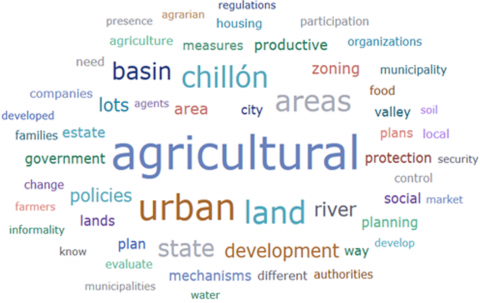
The interview documents were analysed using word cloud analysis using ATLAS.ti 24 to identify the most redundant or most frequently occurring words. Figure 1 (Word Cloud) highlights the most prominent terms related to urban planning and public policies for the protection of peri-urban agricultural soils in the Chillón River basin, Peru.
Figure 1. Word cloud carried out with ATLAS.ti 24
Words such as "agricultural," "urban," "land," "protection," and "Chillón" indicate a direct connection between agricultural land use and urban dynamics in the study area. Terms like "policies," "government," and "zoning" underscore the importance of governance and regulations in this context, while "productive," "development," and "mechanisms" point to the need to balance urban development with the preservation of agricultural lands. These key terms not only emphasize the central themes of the study but also reveal potential areas of intervention and the stakeholders involved. Thus, the word cloud provides a visual summary of the main thematic axes structuring the research and encourages a deeper analysis of the interplay between urbanization and agricultural sustainability.
4.1.1 Category: Urban planning
The category of urban planning is analysed based on its subcategories and emerging subcategories. The first four questions are comprehensively analysed in order to understand the phenomenon and thus take measures for continuous improvement.
Question 1
How do you perceive the effectiveness of current policies and regulations on land use and urban development in the lower Chillón River basin, and what aspects do you think should be improved?
In Peru, the ‘Sustainable Cities’ project is being implemented, which promotes the design and implementation of evidence-based policies, plans and measures for decision-making aimed at sustainable, resilient, inclusive and efficient urban development in Lima and Callao.
On the other hand, the district of carabayllo has a sustainable development plan (emerging code) which faces several challenges including corruption, constant encroachment which generates a large amount of housing that does not comply with current standards on earthquake resistant buildings. A major issue in Carabayllo is the exclusion of the Lomas de Carabayllo as Fragile Ecosystems, approved by Directorial Resolution No. D'000079-2023-MINAGRI-SERFOR-DE, which generates a lot of uncertainty about its protection due to the background of the invasions that are registered in the hills as a result of the informal growth of the city. For that reason, it is highlighted that the importance of SDG number 11 in the district of Carabayllo cannot be underestimated because it must ensure the welfare of its inhabitants. Lack of communication and coordination can hinder the path towards sustainability, which is why it is necessary to connect all relevant actors such as government institutions, businesses and civil society. In the framework of the Peruvian State's duty to achieve significant progress towards the fulfilment of the 2030 Agenda for sustainable development, as well as to ensure the effective enjoyment of the right to a balanced and adequate environment for current and future generations, it is essential to determine the role played by urban planning instruments in this regard, as well as the public policies designed for this purpose. In the Chillón River Valley alone around 4,900 ha have disappeared in the last decades, leaving only 3,148.31 ha in the narrowest part of the valley. The lack of access to formality leads people to resort to informal mechanisms, that is, without respecting the parts of the legal regulations that govern in Peru (informal economy code) to occupy and use land, including agricultural and peri-urban land [21].
(…) We are facing policies that are curative in nature (…) they have this logic of trying to clean up what has already been occupied (E1), (…) what we have been seeing is the presence of pirate real estate companies, which accumulate lands by defrauding the families of the plots and those who are the final users of the lots (E1). (…) Urban occupation should not mean the loss or elimination of productive areas (E1). We should implement the issue of oversight to be able to somewhat eradicate the presence of informal landowners (E2). (…) Municipalities play that oversight role (E1) (…) in the preparation of urban development plans, citizens are not complying because simply, they are not summoned at the right time (E1).
With the details in the previous paragraph and the response of those interviewed, it is evident that in the lower basin of the Chillón River, especially in the Carabayllo area, the lack of municipal supervision allows the continued consolidation of urban developments on agricultural areas and how the formation of this district is closely related to the informal land market and the current regularization only benefits real estate companies and the developers [22].
Most of the time, clientelism accompanies this type of lot recognition. The Peruvian State, since the 60s, began to recognize lots, but left aside the role of developing policies, of a much more preventive nature and also of developing these different social housing programs or policies for the construction and promotion of social housing (emerging code, social criticism). The logic of the state is based on the functionality of an economic power, which is to maintain or allow certain economic groups to develop this type of measures. In this sense, the city of Lima in particular, may have a characteristic, above all, of absorption where the city begins to grow, observing the rental market expanding through productive areas; it is there where the control mechanisms by the state are not working correctly.
There are two key aspects: on the one hand, there is the municipal control mechanism, since municipalities have a supervisory role. In this sense, Ordinance 2288 of Metropolitan Lima, issued on January 11, 2021, establishes in its article 39 urban and environmental control measures. These include the supervision of agricultural, coastal, landscape areas and environmental reserves, with specific guidelines to protect agricultural areas within urban expansion areas. However, these provisions are not being applied effectively. On the other hand, regarding citizen participation methodologies, it is observed that, during the preparation of urban development plans, citizens do not participate as they should, since they are not summoned at the right time.
Question 2
What are the essential elements that you consider should be included in the urban development plans for the lower basin of the Chillón River, and how would you describe the land use zoning process in this region?
The zoning process in the lower basin of the Chillón River must be based on Ecological and Economic Zoning (ZEE), which allows for a rational use of the territory by integrating environmental, social and economic criteria. This approach is essential to balance urban development (emerging code) with the conservation of agricultural and natural areas, thus ensuring long-term sustainability [23].
On the other hand, norms, laws, supreme decrees, among others, have been taken into account as a foundation and legal support. SDG 11: Sustainable Communities and Cities has become a global objective that is aimed at ensuring inclusive and sustainable resilient urbanization of human settlements throughout the world. In the Peruvian context, INACAL, in order to contribute to the fulfillment of the United Nations SDG, approved a new Peruvian Technical Standard (NTP) that provides guidance to achieve an adequate transition from a traditional city model to a more functional, technological and sustainable one.
(…) this part of ecological and economic zoning (E1) should be included. (…) the current zoning process does not take into account the identification of agricultural producers (E2), which is Chuquitanta (…) the government should pay attention to that area so that they continue to preserve agriculture (E2), (…) we have had a comprehensive zoning readjustment where an area of Punchauca has been incorporated into the urban area (E3).
The Bicentennial City Project of the Municipality of Lima and the Port of Chancay (…) will generate a need for housing that will drag the valley of the chillón and if there is no program exclusively for the agricultural areas of the urban areas it will be very difficult to maintain them (E3).
From the interviews conducted and the article on theoretical and empirical design of land use planning, with test data from the Chillón River basin, we can see that it is essential to identify and protect agricultural areas, avoiding their indiscriminate conversion into urban areas and guaranteeing sustainable development [24]. The Food and Agriculture Organization of the United Nations (FAO) highlights that one of the greatest challenges facing soils is sealing or waterproofing, derived from the urbanization processes that affect the main cities of the world [23]. In this context, the inclusion of ecological and economic zoning in urban development plans (emerging code) is crucial to ensure respect for agricultural production. This implies that farmers should be involved during the development of such plans. Although District Municipalities submit proposals, the Metropolitan Institute is in charge of evaluating them to determine which areas can be urban and which should remain rural [14]. This classification is usually based on a traditional approach of urban and rural, although beyond the labels, it is essential to protect agricultural areas as productive spaces versus areas destined for urban growth.
In addition, plans should promote urban and peri-urban agriculture (emerging code), which would help preserve these areas against real estate development, considering that many smallholding families choose to continue producing while others, for various reasons, end up selling their land. However, in terms of zoning, adequate mechanisms are not being implemented, which is a characteristic feature of peri-urbanization in the lower basin of the Chillón River.
Question 3
How would you evaluate the current mechanisms for community participation in urban planning in the lower basin of the Chillón River, and what improvements would you propose to make them more effective?
Urban planning in the lower basin of the Chillón River faces important challenges, especially with regard to the integration of community participation in territorial development processes. Although Law No. 27972 - Organic Law of Municipalities actively encourages citizen participation in territorial management, the results achieved in practice have so far been limited. On the other hand, the Carabayllo Sustainable Urban Development Plan 2019-2029 sets out as a vision that, by 2029, the district of Carabayllo will be a compact, integrated and sustainable city. It also establishes the objective of becoming a space of opportunities, competitive, and inhabited by citizens.
In this framework, the District Urban Plan, regulated by Ordinance No. 1862-2014-MML, plays a key role in providing specific guidelines to guide urban development, although its implementation requires greater efforts to ensure territorial planning that responds to the social, environmental and economic needs of the population.
(…) The last Urban Development Plan 2019-2029 in the case of Carabayllo led to conflicts and tension between those who are dedicated to agricultural activities and those areas that were urbanized by these real estate companies, the municipal agent took sides and they left because of the change in zoning of the area. (E1), (…) only select groups participate in these plans (E1).
For community participation, an organization is needed (…), the associations of conventional farmers who are the majority in the Chillón Valley do not have an idea of associating (E3).
In this type of plans, the improvement would be to take into account the social participation of farmers (E2), the instruments of legibility that the state may have been used appropriately (…) the certificates of possession (…) can have an effect on how the city expands (E1).
Inclusive urban planning in the lower basin of the Chillón River requires not only strengthening community participation but also ensuring that the interests of agricultural communities and other vulnerable groups are respected and prioritized in territorial development [15]. Something that would have to happen in Peru would be a new Agrarian Reform that goes hand in hand with an urban reform that works in an articulated manner and that considers this conjunction of the city and the countryside [25].
In order for communities to have access to basic services, it is necessary to promote the change of zoning. However, during the elaboration of these plans, agricultural producers were not invited, but only the inhabitants of urbanized areas. This fact reflects a tension in the way in which urban development plans are developed, given that there is a fragmentation in territorial planning. On the one hand, those who support the municipal policies of the government in power are invited, while, on the other, those who defend the preservation of productive areas are excluded. This exclusionary approach creates a serious problem since the State tends to apply a corrective policy that, in the long term, increases existing tensions.
Currently, the Metropolitan Planning Institute is working on a broader plan, although the results are still unknown. This plan focuses, among other aspects, on the development of the Chancay airport, which requires special attention due to its direct impact on the Chillón basin. The implementation of this type of infrastructure demands a coordinated approach by local authorities, since the relationship between the port of Chancay and the Chillón basin will be significant.
Based on previous experiences, it is observed that the methodologies used have not been adequate in terms of inclusion. This is because not only farmers or those affected by fraudulent real estate should be considered, but also other key economic actors that contribute to the dynamism of the Chillón basin. Incorporating these agents in urban development plans would be essential to guarantee more inclusive and effective planning. Although state agents are called upon to convene broad sectors of the population, in practice barriers are created that limit participation to select groups, which negatively impacts the results of these plans. Therefore, it is necessary to propose improvements, such as designing urban development plans that guarantee broad citizen participation and appropriately using state regularization instruments, such as certificates of ownership. These certificates not only affect how organizations are formed in peri-urban areas, but also influence the incorporation of productive areas into real estate projects, which is problematic, since many families see this as an opportunity to accumulate capital.
The State, by acting as a promoter of urban expansion, directly affects the loss of agricultural areas. Therefore, it is essential to include ecological and economic zoning, which requires effective coordination between the different levels of government. Currently, there are fractures and duplications in these bodies, aggravated by problems such as land trafficking, in which local authorities are sometimes involved (informal economy code).
The lack of organization between communities and the State, as well as the absence of coordination, impedes adequate planning. In this sense, a possible solution for Peru would be to implement a new agrarian reform that is integrated with an urban reform. This initiative should promote convergence between the city and the countryside, protecting productive areas and effectively linking the different productive systems with urban dynamics.
Question 4
What are the main challenges facing urban planning in the lower basin of the Chillón River, and what opportunities do you see for improving it?
Community engagement, accompanied by grassroots movements, is essential to foster responsible water management practices, such as water conservation, reuse, and recharging groundwater resources. These actions not only help ensure water sustainability but also become fundamental pillars for achieving sustainable urbanization in the future.
In addition, active community participation allows for raising awareness about the importance of efficient water use, thus promoting a culture of collective responsibility. Likewise, these initiatives can be integrated into urban development plans, articulated with public policies that prioritize the comprehensive management of water resources [26].
(…) the challenge of all urban development is the sanitation of water and sewage (E3), (…) lack of articulation of the productive sector with the urbanizations (E2), (…) the State and also these zonal organizations have to get involved in the defense of these agricultural areas and try to have the State develop an adequate urban planning (E1).
The informal subdivision developers do not provide basic services, the same gentlemen who buy these lots claim to be able to have water and electricity (…) and this basic service does not arrive because the soil does not have the conditions, it does not have the zoning change (E2).
As for the opportunities (…) articulation of different productive organizations, also agents that are found throughout the basins, a government by basins would be interesting (E1), at least a pilot project is implemented in which the granting of private administration is provided in what is water and sewage (E3).
It is essential to implement preventive measures that contribute to the rescue of agricultural areas, essential to guarantee food security in Lima. Currently, the loss of agricultural land represents a significant challenge, both for the State and for zonal organizations. Therefore, the latter must actively engage in the defense of these areas and promote the State to develop adequate and sustainable urban planning.
On the other hand, opportunities lie in the articulation between different productive organizations and other agents present throughout the basins. In this context, it would be interesting to explore the possibility of establishing a governance model by basins. This approach could be initiated through a broader articulation that, ideally, includes the active participation of the different levels of government, thus promoting a more integrated and effective management of the territory.
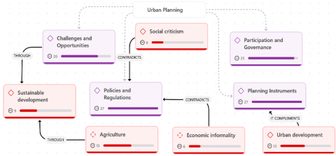
Figure 2. Category, subcategory and emerging urban planning carried out with ATLAS.ti 24
Urban planning, as a main category, articulates different approaches and dynamics that affect the development of cities. The purple subcategories, such as challenges and opportunities, social criticism, participation and governance, policies and regulations, and planning instruments, represent the pillars that structure urban analysis, highlighting those policies and regulations is the most cited with 27 mentions, which underlines its importance as a central axis of the debate. On the other hand, the emerging red concepts, such as sustainable development, agriculture, economic informality, and urban development, reflect specific and complementary aspects that arise from the interactions between the subcategories, with social criticism being the least referenced with only 6 mentions, which could show a need for greater attention to social impacts. While social criticism contradicts normative elements, planning instruments complement urban development processes. In addition, agriculture and sustainable development are linked through challenges related to land management. These connections, together with the frequencies identified, show the tensions and complementarities inherent to urban planning and highlight the need for an integrated vision to address the problem (see Figure 2). The relationships in Figure 2 highlight key tensions and complementarities in urban planning, emphasizing the need to align policies, planning instruments, and sustainable development objectives. Addressing challenges such as social criticism and economic informality requires governance to adopt participatory approaches that integrate stakeholder input and local needs. Strengthening planning tools while fostering collaboration between agriculture, urban development, and sustainability initiatives can promote balanced urbanization. Prioritizing sustainable development ensures long-term resilience and equitable growth in the Chillón River basin.
4.1.2 Category: Protection of peri-urban agricultural soils
The information collected through interviews will be analyzed, providing qualitative data on the topic of study. Subsequently, ATLAS.ti 24 will be used to organize, code, and analyze the data, allowing for the identification of patterns, categories, and subcategories that will facilitate a deeper and more structured interpretation of the results.
Question 5
How would you evaluate the current regulations and strategies for the protection of agricultural soils in the lower basin of the Chillón River, and what aspects do you think could be improved?
The 2024-2030 Multiannual Sectoral Strategic Plan for the Agricultural and Irrigation Sector proposes a series of Sectoral Strategic Objectives aimed at strengthening sustainable development in this area. Among them, the goal of optimizing the sustainable use of natural resources stands out, promoting efficient and responsible use that guarantees their long-term conservation. Likewise, it seeks to increase the resilience of the agricultural sector against the effects of climate change, integrating mitigation strategies that allow minimizing the negative impacts on production systems [27]. Based on the details in the interviews, they mentioned the following:
(…) there is no protection of these agricultural soils, it is non-existent (E1), neither a norm nor a strategy will have an effect if what is sought is to preserve an agricultural passage zone, for something to be preserved there has to be a profitability in the agricultural business (E3).
(…) The Peruvian state only develops recognition of plots, there is no regulation in the strict sense of laws that allow the intangibility of agricultural areas and that the state becomes an important agent in the promotion of social housing, as well as the protection of food sovereignty through the intangibility of agricultural lands (E1).
Current regulations and strategies show important deficiencies, such as the lack of effective legal mechanisms that ensure the intangibility of these areas in the face of the advance of local urbanization [16]. In this sense, the study of the degradation of agricultural soils will allow to estimate areas with different levels of physical degradation of the soil, in order to implement measures and practices for its recovery, management and sustainable management of the soil resource [28].
During the Velasco government, the haciendas located in the valleys of Lima were transformed into agricultural cooperatives as part of his agrarian reform policy. However, towards the end of the 1980s, during the second Belaunde government, these cooperatives began to be parcelled out, giving rise to a process of individualization of the lands. Later, in the 1990s, a significant change occurred when agricultural lands were no longer considered intangible. From then on, the owners had the possibility of selling them freely, a situation that was supported by the Law of Peasant Communities of the Coast, which established that, by assembly decision, the communities could transfer their lands.
This scenario marked the beginning of a process of land liberalization, which coincided with the financial liberalization of the same period. As a result, many families began to establish links with banking companies, although this also exposed them to indebtedness, especially after the closure of the Agrarian Bank. This closure left a gap in agricultural financing, leading families to seek solutions in the land market. Mechanisms such as land leasing and, already in the 2000s, the subdivision of agricultural land by real estate companies emerged.
On the other hand, it is important to note that since the 1960s the State had largely abandoned the policy of developing social housing. This abandonment contributed to agricultural lands becoming increasingly threatened by real estate expansion, intensifying the conflict between urban development and the preservation of productive areas.
Question 6
How would you describe current agricultural soil management practices and restoration projects in the lower Chillón River basin, and what improvements would you suggest to make them more effective?
In the last decade, urban expansion in the lower basin has occurred mainly under two informal modalities: human settlements and commercial developments. One of the main factors that contribute to the imbalances in the urban market is the informality in the urbanization process, coupled with the absence of effective mechanisms to order and regulate its development in an appropriate manner. This lack of formal territorial planning (emerging code) generates disorderly growth, affecting the quality of life and access to basic services.
Regarding restoration projects, it is important to highlight that they are unique, and that the objectives and activities vary according to the specific circumstances of each case. To ensure the success of these projects, it is crucial to establish monitoring mechanisms that address central issues such as environmental sustainability, community participation and effectiveness in the recovery of spaces [29].
(…) restoration projects in the basin do not exist (E2), what is seen is a phenomenon where these informal practices with commercial logics end (E1).
(…) the municipalities that are in charge of developing these control or inspection mechanisms mention that they do not have enough personnel, we are facing a state fragility at the local level but we are also facing a logic of laissez-faire and laissez-passer (E2).
(…) we believe that, designating a group of people, giving them all the powers to travel around the entire Chillón valley and see what is happening with the agricultural areas would be of great help (E2), (…) because local governments are not willing to develop control and inspection measures either, this system of subdivisions simply continues to develop (E1).
One of the negative factors of why agricultural land is being lost is the profitability factor that agriculture represents, its low productivity and reduced promotion, versus its conversion to urban, residential use with greater speculation and expectations in the face of a real estate market [30]. There are no restoration projects in the area, but rather a phenomenon where informal practices end up being linked to commercial logic. For this market logic to work, there must be a perceived need to create real estate programs. Often, companies take advantage of the housing demand of many people; however, although there is a legitimate need for housing, the practices of these irregular companies end up becoming scams, corruption (emerging code). These companies only offer provisional services and, in addition, when someone buys a lot, they do not become the real owner of it, since the owner remains the parceler who sells it to the real estate agency for its subdivision.
As a result, from a single plot between 70 and 100 co-owners can emerge, and the process to make these lots independent can take a long time. In addition, these subdivisions are developed without an adequate zoning change, which aggravates the situation, since it makes access to urban land even more expensive. The municipalities, which are responsible for implementing the control and oversight mechanisms, argue that they do not have sufficient personnel. Thus, we are faced with a weakness of the State at the local level, but also with an attitude of "let it be and let it pass." Local governments, instead of developing effective control and oversight measures, allow the subdivision system to continue without regulation. In this context, talking about restoration mechanisms seems a distant idea.
Question 7
How would you describe the impact of urbanization on food security and the local economy of the lower Chillón River basin, and what measures do you think could mitigate these effects?
The report of the National Agrarian Health Service of Peru
(SENASA) motivated the implementation of the Chillón 2021 Plan, a SENASA initiative aimed at reducing the impact of pesticide use in more than 18,000 hectares of the Chillón Valley, which seeks to produce food free of chemical, physical and biological contaminants for the benefit of public health and thus promote environmental conservation (emerging code). The Agrarian League of the Chillón River Valley denounced the loss of agricultural land, previously used to grow vegetables, and its transformation into land for construction. The organization criticizes the passivity of the authorities who have not stopped real estate projects or regulated the use of the territory [28].
(…) urbanization continues to have an impact if we look over time in the case of Carabayllo, practically 80% of the agricultural area has been lost (E1).
All these urbanizations, the houses that have been settled, have taken away a lot of work from the population, (…) the products that are produced are contaminated since they are irrigated with waste water (E2).
(…) In 2021, the Agrarian League asked SENASA to provide information to know the results of the analysis of toxic residues in vegetables and greens that are harvested in the Chillón valley, which are sold in different local markets. SENASA issued a report showing that the products of the Chillón valley are contaminated and exceed 40% (E1).
(…) it would be necessary to implement agricultural technologies that are in line with the care of the soil and water and that eliminate this high intermediation for the commercialization of their products by farmers, (…) an agrarian reform that goes hand in hand with an urban reform in which it works in an articulated manner (E1).
This integrated approach would mitigate the impacts of uncontrolled urbanization, safeguard food security and promote a more sustainable development model in the lower basin of the Chillón River [31].
Urbanization continues to have an impact if we look at Carabayllo over time, practically 80% of the agricultural area has been lost.
In 1972, certain information collected indicates that the district had more than 5,414 hectares of agricultural area. 20 years later it had 5,098 hectares, but from 1990 to the present, the loss of agricultural land has been brutal.
The Municipality of Carabayllo indicated in 2019 that only 1,216 hectares remain. Urbanization has had an effect on food security. The figures are quite noticeable and it also influences climatic factors and the loss of biodiversity, and this generates drastic changes in the temperature change of the basin.
The water problem is something that the country is experiencing and the Chillón basin is not going to be alien to this reality. We see a problem that ranges from the reduction of agricultural land to the contamination of water sources.
The measures taken in the 90s with the liberalization of the Private Bank and these measures of the government in power led to families not having references to continue producing their land, so they began to cultivate without a cultivation plan, whereas when the Agrarian Bank existed, it required a cultivation plan.
What has happened since then is the contamination of the soil, on the one hand, it is the loss of agricultural land and the contamination of the soil of the Basin is added, which ultimately causes contaminated products to be produced.
Question 8
What collaborative initiatives and educational programs on the protection of agricultural soils are being implemented in the lower basin of the Chillón River, and how do you evaluate their effectiveness?
In 2021, the Ministry of the Environment (MINAM) prepared the Diagnosis of Ecosystem Services in the Chillón River Basin, which indicates that the municipalities located in the basin find that the elements that would be affecting the basin are environmental pollution due to the accumulation and clandestine burning of garbage and stubble, wastewater, deforestation, uncontrolled breeding of domestic animals, and mining tailings [32].
(…) no awareness talks have been held (E2). (…) there are no educational programs on the protection of agricultural soils. What there is is the emergence of social and agricultural organizations that are working for the protection and recovery of agricultural areas (…), which are the Cooperativa del Valle, the Agrarian League, the Assembly of Peoples of Lima Norte and the Chillón Basin (E1).
The absence of institutional efforts to complement these community actions limits the overall impact on the sustainability of the valley. It is essential that the Ministry of the Environment, in conjunction with local municipalities, resume and strengthen environmental education and citizen awareness initiatives [33].
There are no educational programs on the protection of agricultural land. What there is is the emergence of social and agricultural organizations that seek the protection and recovery of agricultural areas and the protection of marginal strips that can serve as public spaces for the recreation of the population. The part of legislation (emerging code) that exists is a salute to the flag in what refers to the protection of agricultural land.
There are efforts by these organizations to fight for the intangibility of agricultural land; in political terms, they are also fighting for better access to the market without intermediaries, and to stop soil contamination so that the food sovereignty of the city is guaranteed.
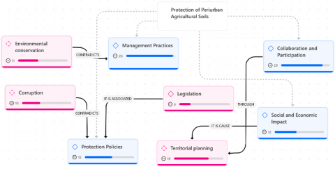
The protection of peri-urban agricultural land, as a main category, addresses the dynamics and factors that affect the sustainability of these territories [18]. The blue subcategories, such as management practices, collaboration and participation, and social and economic impact, highlight key aspects in the management of these soils, with management practices being the most cited with 26 mentions, reflecting its central importance in the implementation of effective strategies. On the other hand, the emerging pink concepts, such as environmental conservation, corruption, protection policies, legislation and territorial planning, address associated and critical factors that influence the success of these initiatives, highlighting that corruption is the least cited with only 9 mentions, which could indicate limited attention to this aspect in the analysis. These relationships show the need to integrate achievable and realistic criteria in social, legal and ethical aspects to ensure the sustainability of peri-urban agricultural soils (see Figure 3).
Figure 3. Category, subcategory and emerging with peri-urban protection of agricultural lands carried out with ATLAS.ti 24
As a future suggestion, the protection of peri-urban agricultural soils should prioritize a balanced approach that enhances management practices while addressing overlooked factors like corruption, legislation, and territorial planning. Developing comprehensive strategies that integrate ethical, social, and legal dimensions will ensure more sustainable and resilient outcomes. Additionally, fostering greater collaboration among stakeholders and strengthening governance mechanisms can further support the long-term preservation of these vital agricultural areas.
The analysis of Table 1 shows a diverse distribution in the mentions of the codes between the two interviews and their cumulative total. In the first interview, 111 citations were recorded, while in the second, this number increased to 159, reflecting a greater depth or diversity of topics addressed in the second case. The most cited codes in total were Planning Instruments and Policies and Regulations, both with 27 mentions, which underlines their central relevance in the analysis. These codes likely reflect the foundational elements necessary for effective governance and the structuring of peri-urban agricultural protection, emphasizing their priority in the discourse. In contrast, the least mentioned were Social Criticism, Legislation and Economic Informality, each with only 6 citations, which could indicate a less detailed focus or less priority on these aspects. This discrepancy may suggest that these aspects were either less emphasized in the interviews or are areas that require further investigation This pattern suggests that topics related to normative structure and organization are the most prominent, while peripheral critical and economic dynamics require further exploration to balance the analysis. In total, 270 mentions were accumulated, reflecting a considerable effort in capturing the complexity of the topics analyzed. The limited focus on Social Criticism and Economic Informality could imply a need to incorporate broader socio-economic and critical perspectives to provide a more balanced and comprehensive analysis.
Table 1. Code and document analysis carried out with ATLAS.ti 24
|
Code |
Interview 1 |
Interview 2 |
Totals |
|
Agriculture |
6 |
9 |
15 |
|
Challenges and opportunities |
6 |
14 |
20 |
|
Collaboration and participation |
7 |
16 |
23 |
|
Corruption |
3 |
7 |
10 |
|
Economic informality |
4 |
2 |
6 |
|
Environmental conservation |
5 |
6 |
11 |
|
Legislation |
3 |
3 |
6 |
|
Management practices |
10 |
16 |
26 |
|
Participation and governance |
10 |
15 |
25 |
|
Planning instruments |
12 |
15 |
27 |
|
Policies and regulations |
11 |
16 |
27 |
|
Protection policies |
9 |
6 |
15 |
|
Social and economic impact |
7 |
5 |
12 |
|
Social criticism |
2 |
4 |
6 |
|
Sustainable development |
2 |
7 |
9 |
|
Territorial planning |
7 |
12 |
19 |
|
Urban development |
7 |
6 |
13 |
|
Totals |
111 |
159 |
Overall, the pattern observed underscores a predominant focus on organizational and regulatory frameworks while suggesting an opportunity to deepen the exploration of social, legislative, and economic dynamics. This balanced approach could enhance the robustness of the analysis and its relevance to addressing the multifaceted challenges of peri-urban agricultural soil governance.
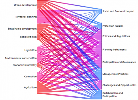
The Sankey diagram shows the interrelationship between the emerging codes, located on the left side, and the overall subcategories of the two large categories, represented on the right side. The emerging codes such as urban development, territorial planning, sustainable development, social criticism, legislation, environmental conservation, economic informality, corruption and agriculture reflect the multiple dimensions and approaches of the analysis. On the other hand, the overall subcategories, such as social and economic impact, protection policies, policies and regulations, planning instruments, participation and governance, management practices, challenges and opportunities, and collaboration and participation, show the structural axes that articulate the various emerging aspects. The connections reflect flows of influence and relationship, where codes such as urban development and sustainable development are especially linked to social and economic impact, while codes such as corruption and social criticism show more specific relationships with policies and regulations. This overview highlights the complexity of the processes analyzed and the need for integrative approaches to effectively address the identified problems (see Figure 4). The Sankey diagram underscores the complexity and interconnectedness of the analyzed processes, revealing how emerging codes and structural subcategories influence one another. It highlights the pivotal role of urban and sustainable development in shaping social and economic impact, while issues like corruption and social criticism require targeted attention within policies and regulations. This complexity calls for integrative and multidimensional approaches to effectively address the challenges and opportunities identified in the analysis.
Figure 4. Co-occurrence analysis of main codes using Sankey diagram carried out with ATLAS.ti 24
4.2 Proposal
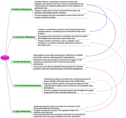
Figure 5 shows the proposal in five dimensions: political, economic, social, environmental and legal. This proposal will allow alternatives to minimize the problem for the benefit of all those involved. It must be analyzed with a holistic and dialectical view, which allows for transformation in practice through action.
Figure 5. Proposal for continuous improvement
The political dimension emphasizes the necessity for coordination among legislative, executive, and municipal authorities to integrate governance frameworks that align urban development with agricultural soil protection. It calls for the establishment of interinstitutional action plans with clear objectives, roles, and monitoring mechanisms to ensure effective collaboration and stakeholder engagement.
The economic dimension focuses on conducting a financial impact analysis of proposed policies, ensuring that the benefits outweigh the costs. It highlights the importance of incentivizing private investment in sustainable agricultural practices and urban projects, as well as creating economic tools such as subsidies or tax exemptions to encourage soil preservation.
The social dimension underlines the need for community participation, particularly involving residents near the Chillón River, to address local concerns and foster collective responsibility. It proposes educational initiatives to raise awareness about the value of agricultural soils and the establishment of inclusive decision-making spaces to incorporate diverse perspectives.
The environmental dimension stresses the importance of continuous environmental impact assessments to mitigate human activities affecting the region. Aligning local actions with the United Nations' Sustainable Development Goals (SDGs) and restoring degraded ecosystems are critical components of this approach.
Finally, the legal dimension advocates for the revision and updating of legal frameworks to reflect the needs of local populations and environmental demands. It calls for stronger enforcement mechanisms and new regulations to safeguard agricultural soils, ensuring their compatibility with urban growth.
Promote integrated and balanced urban planning that allows for sustainable development in peri-urban agricultural lands, respecting the guidelines established in the 2030 Agenda for Sustainable Development Goals (SDG). Agriculture in peri-urban lands must be considered within an urban planning framework that guarantees the preservation of these productive areas while meeting the demand for urbanization in areas such as the lower basin of the Chillón River, in Carabayllo. The implementation of public policies that promote urban and peri-urban agriculture, together with the protection of agricultural lands, is essential for the economic, social and environmental well-being of the region. As future work, it is recommended to carry out mixed research that integrates both qualitative and quantitative methodologies, with active participation of all the actors involved, including local authorities, residents, and experts in urban planning and agriculture. Likewise, the incorporation of innovative technologies is crucial to optimize the processes of planning, monitoring and territorial management, guaranteeing greater efficiency in decision-making and the use of resources. This multidisciplinary and technological approach would contribute to a more inclusive, equitable and sustainable urban development model for the lower basin of the Chillón River and other peri-urban areas of the country.
Thanks to the University of Sciences and Humanities for supporting the research Project.
[1] Brunt, L., García-Peñalosa, C. (2022). Urbanisation and the onset of modern economic growth. The Economic Journal, 132(642): 512-545. https://doi.org/10.1093/ej/ueab050
[2] Aldulaimi, S., Abdeldayem, M., AboKeir, M.Y. (2023). Sports tourism as a catalyst for achieving Sustainable Development Goals (SDGs). International Journal of Sustainable Development and Planning, 18(12): 3947-3954. https://doi.org/10.18280/ijsdp.181225
[3] Moisa, M.B., Gemeda, D.O. (2021). Analysis of urban expansion and land use/land cover changes using geospatial techniques: A case of Addis Ababa City, Ethiopia. Applied Geomatics, 13(4): 853-861. https://doi.org/10.1007/s12518-021-00397-w
[4] Jiménez Aliaga, R., De los Ríos-Carmenado, I., San Martín Howard, F., Calle Espinoza, S., Huamán Cristóbal, A. (2022). Integration of the principles of responsible investment in agriculture and food systems CFS-RAI from the local action groups: Towards a model of sustainable rural development in Jauja, Peru. Sustainability, 14(15): 9663. https://doi.org/10.3390/su14159663
[5] Cortes, S.T., Bugtai, V.H., Lampawog, E.Q., Sadili, C.B., et al. (2022). Assessing problems and prospects of urban agriculture in Cebu City, Philippines: Towards developing action plans. Journal of Nusantara Studies, 7(1): 264-291. https://doi.org/10.24200/jonus.vol7iss1pp264-291
[6] Dubbeling, M.C., Merzthal, G., Soto, N. (2010). Multistakeholder policy formulation and action planning for urban agriculture in Lima, Peru. Journal of Agriculture, Food Systems, and Community Development, 1(2): 145-154. https://doi.org/10.5304/jafscd.2010.012.010.
[7] Sareen, S., Haque, M. (2023). Exploring the evolution and trends in the peri-urban planning: A bibliometric overview. International Journal of Sustainable Development and Planning, 18(12): 3855-3866. https://doi.org/10.18280/ijsdp.181217
[8] Salmoral, G., Carbó, A.V., Zegarra, E., Knox, J.W., Rey, D. (2020). Reconciling irrigation demands for agricultural expansion with environmental sustainability-A preliminary assessment for the Ica Valley, Peru. Journal of Cleaner Production, 276: 123544. https://doi.org/10.1016/j.jclepro.2020.123544
[9] Palanca, M.T.B. (2016). New criteria of environmental control for activities implementation in Valencian urban management. Environmental & Economic Impact on Sustainable Development, 11(6): 864-874. https://doi.org/10.2495/SDP-V10-N1-864-874
[10] Du, L., Liu, X., Sun, H. (2024). Corporate sustainable development strategies: Under the collaborative governance of government and the public. Sustainable Development, 32(4): 3055-3064. https://doi.org/10.1002/sd.2827
[11] Duan, Y., Tang, J., Li, Z., Yang, Y., Dai, C., Qu, Y., Lv, H. (2022). Optimal planning and management of land use in river source region: A case study of Songhua River Basin, China. International Journal of Environmental Research and Public Health, 19(11): 6610. https://doi.org/10.3390/ijerph19116610
[12] Kinuthia, H., Majale, C., Letema, S. (2021). Influence of public policy planning on peri-urban land speculation in (Greater) Eastern Bypass in Nairobi Metropolitan. Land Use Policy, 107: 105515. https://doi.org/10.1016/J.LANDUSEPOL.2021.105515
[13] Schreiber, K., Winkler, K.J., Abellon, K., MacDonald, G.K. (2023). Planning the foodshed: Rural and peri-urban factors in local food strategies of major cities in Canada and the United States. Urban Agriculture & Regional Food Systems, 8(1): e20041. https://doi.org/10.1002/uar2.20041
[14] Akimowicz, M., Cummings, H., Képhaliacos, C., Landman, K. (2019). Peri-urban agricultural policies in Canada and France. In The Routledge Handbook of Comparative Rural Policy. Routledge, pp. 481-486. https://doi.org/10.4324/9780429489075-37
[15] Filepné Kovács, K., Varga, D., Kukulska-Kozieł, A., Cegielska, K., et al. (2024). Policy instruments as a trigger for urban sprawl deceleration: Monitoring the stability and transformations of green areas. Scientific Reports, 14(1): 2666. https://doi.org/10.1038/s41598-024-52637-9
[16] Hamzens, W.P.S., Moestopo, M.W. (2020). Development of agribusiness places on Palu riversides. AGROLAND The Agricultural Sciences Journal (e-Journal): 7(2): 106-115. https://doi.org/10.22487/agroland.v7i2.626
[17] Marchetti, M., Vizzarri, M., Sallustio, L. (2019). Towards countryside revival: Reducing impacts of urban expansion on land benefits. In Agrourbanism: Tools for Governance and Planning of Agrarian Landscape. Springer, Cham, pp. 207-222. https://doi.org/10.1007/978-3-319-95576-6_13
[18] Marshall, F., Dolley, J., Bisht, R., Priya, R., et al. (2024). Recognising peri-urban ecosystem services in urban development policy and planning: A framework for assessing agri-ecosystem services, poverty and livelihood dynamics. Landscape and Urban Planning, 247: 105042. https://doi.org/10.1016/j.landurbplan.2024.105042
[19] Russo, P., Tomaselli, G., Pappalardo, G. (2014). Marginal periurban agricultural areas: A support method for landscape planning. Land Use Policy, 41: 97-109. https://doi.org/10.1016/j.landusepol.2014.04.017
[20] Safitri, K.I., Abdoellah, O.S., Suparman, Y., Mubarak, A.Z. (2021). The existence of subsistence, semi-commercial and commercial urban agriculture in Bandung Metropolitan, Indonesia. International Journal of Sustainable Development and Planning, 16(8): 1425-1436. https://doi.org/10.18280/ijsdp.160803
[21] Meenar, M., Morales, A., Bonarek, L. (2017). Regulatory practices of urban agriculture: A connection to planning and policy. Journal of the American Planning Association, 83(4): 389-403. https://doi.org/10.1080/01944363.2017.1369359
[22] Niemelä, J. (1999). Ecology and urban planning. Biodiversity & Conservation, 8: 119-131. https://doi.org/10.1023/A:1008817325994
[23] Horst, M., McClintock, N., Hoey, L. (2024). The intersection of planning, urban agriculture, and food justice: A review of the literature. In Planning for Equitable Urban Agriculture in the United States: Future Directions for a New Ethic in City Building. Springer, Cham, pp. 89-120. https://doi.org/10.1007/978-3-031-32076-7_6
[24] Davis, S., Chen, G. (2022). Community perception of animal-based urban agriculture within city greenspaces of the global north: A survey of residents near Cornwall Park, New Zealand. Sustainability, 14(19): 12419. https://doi.org/10.3390/su141912419
[25] Zhai, Y., Huang, X., Na, Y., Huang, K. (2023). Research on village planning strategy in northern ecological conservation area under the background of rural revitalization. Science Discovery, 11(3): 121-127. https://doi.org/10.11648/j.sd.20231103.17
[26] Kookana, R.S., Drechsel, P., Jamwal, P., Vanderzalm, J. (2020). Urbanisation and emerging economies: Issues and potential solutions for water and food security. Science of the Total Environment, 732: 139057. https://doi.org/10.1016/j.scitotenv.2020.139057
[27] de Moura, M.S., da Silva, V.C., Pacheco, F.A.L., Fernandes, L.F.S., Pissarra, T.C.T., da Costa, A.M. (2024). Beyond land use planning and ecosystem services assessment with the conservation use potential framework: A study in the upper rio das Velhas Basin, Brazil. Science of the Total Environment, 923: 171437. https://doi.org/10.1016/j.scitotenv.2024.171437
[28] El Idrissi, A. (2022). Towards a regulatory planning of conflicts related to the use in peri-urban and rural areas. African Journal on Land Policy and Geospatial Sciences, 5(2): 405-426. https://doi.org/10.48346/IMIST.PRSM/ajlp-gs.v5i2.29149
[29] Lawton, A., Morrison, N. (2022). The loss of peri-urban agricultural land and the state-local tensions in managing its demise: The case of greater western Sydney, Australia. Land Use Policy, 120: 106265. https://doi.org/10.1016/j.landusepol.2022.106265
[30] Moreno-Casasola, P. (2022). The challenge of participatory restoration in rural areas. Botanical Sciences, 100: 218-244. https://doi.org/10.17129/botsci.3149
[31] Nikolaidou, S. (2021). Peri-urban agriculture and alternative food networks in Athens: Solidarity dynamics, spatial planning challenges and institutional reforms. Cahiers de la Méditerranée, 102: 89-107. https://doi.org/10.4000/cdlm.14449
[32] Ezeadichie, N.H., Onodugo, V.A., John-Nsa, C.A. (2022). Dialectics of mainstreaming agriculture in urban planning and management of cities of the global south. In Sustainable Development Dimensions and Urban Agglomeration. IntechOpen Limited, pp. 161-168. https://doi.org/10.5772/intechopen.104269
[33] Zhavoronkova, N.G., Vypkhanova, G.V. (2021). Legal problems of public policy and strategic planning of land management. Lex Russica, 74(2): 50-63. https://doi.org/10.17803/1729-5920.2021.171.2.050-063