Wazeen Wafeeq Nasser![]() | Rana Mazin Mahdi*
| Rana Mazin Mahdi*![]()
© 2023 IIETA. This article is published by IIETA and is licensed under the CC BY 4.0 license (http://creativecommons.org/licenses/by/4.0/).
OPEN ACCESS
This study, set within the context of contemporary housing projects, focuses on the development of urban values through mechanisms associated with the intervention strategy, particularly the flexible juxtaposition mechanism to ensure its permanence. The research springs from the requirement for residential environments boasting attractive urban standards that are amenable to intervention and development. The study uses the housing project of hope in Basra-Iraq, one of the most popular contemporary residential projects, as a case study. The research aims to articulate an intervention mechanism by developing a theoretical framework based on the juxtaposition mechanism. This mechanism facilitates the development of values and enhances their robustness over time. The research provides comprehensive knowledge about the positive relationship between values and their development mechanism within the residential landscape context. The study addresses the research question concerning the nature of the relationship between the intervention strategy mechanisms and housing stability. It employs morphological analysis through the ArcGis program, which gauges the main axis network of the selected residential project and its relationship with the neighborhoods and the mother city. The analysis used indicators — connectivity, integration, and control — at the level of the residential project and the whole with the mother city. In addition to using a descriptive analysis form with expert assistance to identify the attractive factors of modern housing and analyze them, the study leads to conclusions that indicate the most important urban values influencing and attracting the site are its connectivity and integration with the mother city and the neighborhoods. The methods used to measure these values can be applied to establish laws and standards for designing successful environments using interventional mechanisms.
attractive housing values, intervention strategy, residential projects, urban morphology, space syntax, connectivity analysis, Basra
The concept of attractive values for residential projects has clearly emerged during the modern era, fueled by the evolution of life, the pursuit of investment competitiveness, the enhancement of living environments, and the mitigation of local and global disparities. Over time, the focus of these attractive values has shifted. Initially centering on social, economic, and environmental aspects—the triple sustainability values—it has recently broadened to include educational, health, economic, and urban values—the quadruple contemporary values.
To keep pace with these developments and address the challenges faced by residential environments, the concept of intervention strategy has been introduced. This strategy is characterized by its two types: long-term and short-term. The choice depends on various factors such as the nature and location of the intervention, its duration, and the responsible authority—be it the resident, designer, or investor. Each mechanism's indicators vary according to the value it aims to enhance and sustain over time.
The current study centers on the Al-Amal housing project, located south of the city of Basra, near Shatt al-Arab from the west and the Sport City in the south. The project stands out due to its attractive urban values, which contribute to enhancing housing stability through the mechanism of the intervention strategy known as juxtaposition.
The aim of the research is twofold: to analyze the role of the juxtaposition mechanism in developing attractive architectural values in the Al-Amal residential project, and to assess the connectivity and integration of Al-Amal with surrounding neighborhoods and the city center.
A comprehensive evaluation of the study area—the Al-Amal residential project in the city of Basra, Iraq—was conducted using the ArcGis program. This analysis focused on the project's road network and its relationship with the neighborhoods and the city center, identifying the most significant attractive axes.
The study probes urban indicators that achieve attractiveness, such as connectivity, integration, control, privacy, and a sense of place. These are examined at both the project level and the entire city level, with a focus on the project's relationship with the city center.
The research identifies and addresses the knowledge gap concerning movement axes and open residential spaces. The Al-Amal housing project showcases several mechanisms of urban intrusion, including activities, lifestyles, and urban styles within open spaces and axes. These mechanisms are evident at the project level, in relation to the city, and around attractive focal points in and near the project.
The research emphasizes the need for integration between attractive urban values and the juxtaposition mechanism. This integration is crucial to maintaining the attractiveness of residential projects over time.
The remainder of the research is organized as follows:
The second section, "Materials and Methods," reviews previous literature pertaining to the main research axes. It then formulates a theoretical framework after exploring juxtaposition indicators and their types related to the intervention strategy for the urban values of contemporary residential projects. The study area is defined, and an analysis is conducted.
The third section, "Results and Conclusions," presents a thorough evaluation of the project's attractive urban values, along with a discussion of the analysis results. The theoretical framework indicators are then applied to verify the research hypothesis.
The final section offers conclusions and recommendations, identifies beneficiaries, outlines future research horizons, and provides a summary message to the readers of the research.
2.1 Literal review: Definition and concepts
2.1.1 Attractive values
In Arabic, attraction refers to drawing attention towards something, with attention defined as: “a state of mind in which people direct their cognitive and scientific activity towards a subject or action". Attention can be divided into two types: involuntary and voluntary [1]. In English, the term 'Attractive' signifies drawing attention, fascination, charm, or allure towards a specific thing to an extent that it holds one in awe. It can also be understood in the sense of 'interesting'. Thus, we can describe a residential urban environment as attractive due to the suspense it creates for the observer [2].
According to Schulz, an attractive residential environment is one where its location holds multiple considerations, serving as both a point of arrival and departure. It is characterized by diverse spaces that work on attraction [3]. Variables such as housing, means of transportation, diversity of classes, richness, and consideration of the time factor are the strongest attractors.
Designers in housing projects have adopted several concepts to achieve attractive values, among which are:
Suspense: Designers attempt to strengthen the element of suspense at a functional level, particularly in straight paths and walking areas. Bland paths for pedestrians, bicycles, or cars are enlivened by distinctive signs, monuments, green or blue areas parallel to walking paths, resting places, kiosks, or squares at the end of a street with distinct recreational use. In residential areas that are often characterized by a repetitive pattern, suspense is used to break the monotony. Children’s play areas, for example, serve as hubs for gathering housing around them and are designed in different ways that include multiple activities, open green spaces, games, walking paths, and seating terraces in different forms (single/movable/static). The objective of these functional and aesthetic suspense elements is to provide a sudden transition to a spacious place or to present a distinctive element from afar that attracts the observer towards it without feeling bored until they reach the objective [4].
Surprise: Surprise in the residential environment is achieved, for example, through bends or refractions in passages, so that the observer is surprised by hidden elements that suddenly appear at each bend or refraction in a motor axis. The elements of surprise are represented by new treatments, modern methods, and aesthetic sizes and shapes [5].
Pleasure: The residential environment can provide pleasure as one of its attractions. This can be achieved through the selection of a new pattern for a specific space that differs from the pattern of other spaces, the use of unfamiliar designs, aesthetic pleasure available through open green and blue spaces, color, lighting, building materials, and the functional pleasure that achieves uniqueness in the residential environment through non-stereotypical functional solutions that perform their function in a distinctive way, away from imitation and boredom [6].
Researchers have interpreted attractive values as creative products or distinctive features achieved through persistence in a work that was produced intentionally [7]. The values of the designer, to be attractive, must be creative and produce a positive evaluation by the inhabitant. Attraction is accomplished through the element of surprise in devising a solution to an existing problem or meeting a new need in a different and creative way.
Through the above, attractive values can be defined as the elements or qualities that achieve uniqueness, distinction, and creativity. They provide elements of amazement and surprise, and achieve visual and sensory pleasure for the inhabitant and the observer, through designs with modern ideas, attractive spatial relationships, and organization. This applies to values in general. As for attractive housing values, they will be summarized in the following paragraph.
2.1.2 Attractive housing values
An attractive residential project is defined as a place characterized by a unique design with clear boundaries and cohesive links both within the neighborhoods and the new project itself. Such a project not only provides comfort and luxury but also introduces commercial or industrial sectors that offer capital and job opportunities. These sectors contribute to investment, thus becoming tools of attraction [8, 9]. When the urban environment caters to natural landscapes, social interactive spaces, entertainment, and urban economy areas, it becomes attractive to various levels, including residents, designers, and investment companies.
The attractiveness of a residential project also relies on public spaces, local styles, and the use of sustainable building materials. The visual image of the place must be appealing in all its elements to be attractive. These elements include landscape, sidewalk type, location and quality of green spaces, sub-spaces, street furniture, lighting, and aesthetic monuments or agriculture. Agriculture, in particular, markedly enhances the quality and attractiveness of the place since it provides a pleasant feeling by cooling the area and shielding it from the sun's rays. The site's topography is also considered one of the most important attractive elements [10].
Attractive values vary from one place to another and from one environment to another. Attractive projects hinge on studying the housing patterns of a specific community and addressing the problems of their urban environments in a way that aligns with the customs, traditions, and current situation of the place [11, 12].
Modern attractive housing values are of two kinds. Pre-work values include the site, environmental and residential diversity, job opportunities it offers, and advertising and marketing campaigns, along with the project's appealing design. Post-work attractive values of residential projects are represented by periodic and temporary maintenance, excellent management, and temporary and permanent interventions and improvements, which enhance the residents' sense of place value [13].
Post-occupancy attractive housing values are adopted by the administration and the investor in cooperation with the residents for the purpose of creating new, lively, and attractive spaces. These values rejuvenate and enhance places, making the residential environment attractive to its residents for extended periods [14, 15].
Values that meet the maximum possible amount of needs and correspond to the needs of the time and place are the most influential, most desired, and therefore most attractive. Housing project values have patterns between studies [16-18] that can be achieved to generate more attractive projects, including social, economic, urban, and environmental, health, educational, and cultural values. The key aspects of these patterns can be illustrated through Figure 1.
Figure 1. The types of contemporary housing values (prepared by the two researchers)
Table 1. The development in housing values and contemporary attractive house
|
Contemporary Attractive Housing Values |
Contemporary Housing Values |
Values |
|
Creating spaces for social interaction-organized and electronically monitored safety and security-a diverse and homogeneous distribution-reducing class differences-encouraging social sustainability-social participation |
Justice-security-privacy |
Social values |
|
Proximity to the economic core-encouraging investment-self-sufficiency-encouraging economic sustainability |
Providing job opportunities-low costs-using local material |
Economical values |
|
Dealing with nature-Encouraging sustainability-Encouraging the ecosystem-Increasing the percentage of green and open spaces |
Integration with nature-green area |
Environmental values |
|
Flexible adaptive design-integrated with land uses-subject to future expansion-maintenance, renewal and continuous intervention-smart digital smart living technologies |
(Functional and formal values) Achieve an integrated design, easy access, and integrated services |
Architectural values |
|
Green open spaces for psychotherapy-external medical cadres and expertise-interest in health institutions in a modern style and smart digital management |
Reducing pollution-diseascontrolro |
Smart-living |
|
Introducing international scientific names within health institutions-Providing smart digital education capabilities |
Providing educational institutions at different levels (primary-secondary-universities-kindergartens) |
Educational values |
|
Paying attention to cultural entertainment institutions-diversifying events, occasions and festivals |
Preserving historical areas-strengthening identity |
Cultural values |
Source: Researchers
The main differences between traditional housing values and contemporary housing values can be clarified through Table 1, based on scientific studies [19-21].
In conclusion, the evolution in housing values over time is the outcome of a strategy of interventions with modern technologies and the creation and development of other values depending on the region's nature and its residents' needs. Previously, housing values depended on formal functional solutions, whereas today they are sustainability solutions (economic-social-environmental) at the core of solving housing problems, supported by modern smart interventions. This topic will be discussed further in the next paragraph.
2.1.3 Residential intervention strategy
The concept of an intervention strategy emerged as a response to the need for development, to reduce disparities on various levels, and to confront emergency crises. The housing intervention strategy can be defined as operations undertaken by governmental or official agencies, or through community participation. These operations aim to increase stability, create prosperity, attract residents, and ultimately increase housing stability. They also focus on efficient management to address problems, enhance chances of obtaining safe and habitable housing, achieve self-sufficiency, preserve family units, enhance a sense of belonging to the place, create a positive reputation for it, and develop attractive values within it [21].
Housing intervention levels can be classified into long-term interventions that start before the works and continue after them, ensuring ongoing development. Short-term interventions, on the other hand, are represented by developmental additions such as events and festivals. Housing interventions vary in different regions – some preserve the heritage of a region, some enhance a sense of belonging to it, while others revive a neglected job or an obsolete building [22].
Contemporary housing project interventions aim to increase population stability in their areas and preserve the reputation of the place. The intervention strategy is characterized by several mechanisms including juxtaposition, improvement, and tactics - each depending on the nature of the attractive goal to achieve development [23, 24].
2.1.4 Juxtapoisition mechanism
One of the intervention strategy mechanisms is juxtaposition. This is an intervention process represented by placing two objects in close proximity in a way that makes each of them more distinct through the approach of integrating disparate elements or environments. Successful juxtaposition is termed positive interposition, while the negative lacks in scientific study. The types of the juxtaposition mechanism can be clarified as follows:
- At the material level: This is one of the most common architectural sections at present. Examples include using stone material with glass material in the facades or employing sharp forms and materials with opposite characteristics. This creates an aesthetic distinction if the juxtaposition is positive, but it can create visual and architectural noise otherwise.
- At the shape level: The nature of the interlacing of forms is more blatant than the material. Some shapes symbolize softness, while others symbolize prestige, solemnity, and greatness. Each form produces a distinct or simple juxtaposition depending on the dynamic nature of the merger between the new element and the old element.
- At the internal and external level: Architects nowadays strive to create distinction inside and outside by changing their relationship or their continuity. As creating different aesthetics and pleasure between the inside and the outside would increase the attractive values and draw attention to each of them.
- At the surrounding or context level: In general, residential or architectural projects are not presented in isolation from the context or the surroundings. The context provides several ways to achieve interpenetration, for example, interjection between old and new, between historical regions and the age of technology and smart digital, and between natural environments and traditional environments [23].
The integration of organic environments with engineering or organic with deconstruction, or deconstruction with engineering, using advanced modern technologies, can contribute to attracting the population and provide them with a variety of alternative solutions. The provision of diversity in services and attention to the site and the population would increase the chances of population attraction to the region. Consequently, the study showed the most important contemporary housing interventions [24].
In conclusion, the integration between buildings and making them unified, i.e., becoming a single area and the integration of the neighborhood into the city, relies on creating all the conditions for creating a dynamic architectural environment that takes into account harmony and architectural and social integration [25]. As architectural integration means harmony, communication and compatibility between intellectual currents to achieve progress through collective efforts [26]. As for the addition, it is the addition of different and dissimilar elements to each other or to an existing system in a manner that modifies and changes it, in whole or in part, according to various artistic techniques such as assembly, pasting, installation, montage, and collage [27]. This results in a crucial link between the past and the present and between the old and the new [28].
2.2 Theoretical framework
Analyzing various studies within the research limits, we identified indicators for the juxtaposition mechanism to enhance architectural attractiveness in a residential context. We considered different types of juxtaposition: smart digital, ecological, and architectural juxtaposition:
Smart digital juxtaposition: This type of juxtaposition involves smart systems in building management and residential settings in general. Management tasks extend beyond service provision to include computer-assisted operation and control. This category includes various types of smart digital juxtaposition, such as security systems, monitoring systems, remote management and control organizations, lighting systems, and service systems (water, electricity, firefighting, communication, and data transfer) [22]. This type encompasses digital juxtaposition inside and outside buildings. The research used questionnaires and detailed analysis to measure indicators of digital juxtaposition.
Ecological juxtaposition: This involves the integration or addition of systems that cater to occupant needs, enhance the biosphere, and improve environmental conditions by integrating built and unbuilt areas with green and blue spaces. The goal is to achieve environmental development within the project and balance between humans and nature. This system includes several indicators, such as designing corridors and walkways with an ecological system that simulates nature, incorporating green and blue areas in their design, using visual and kinetic communication through open or semi-open walls on green spaces, and using blue spaces like fountains and swimming pools as ecological additions to buildings and housing [23]. The ecological juxtaposition exists within open spaces, public spaces, movement axes, and building facades. The research employed questionnaires and detailed analysis to measure indicators of ecological juxtaposition.
Architectural juxtaposition: This type of juxtaposition operates within a holistic and partial system. The addition of a residential project within the city fabric is itself an urban juxtaposition if it achieves connection with the main city and integration with the neighborhoods. This creates an external attraction within controlled, easily accessible axes, achieving this type of urban inclusion. Internally, within the project, the juxtaposition mechanism operates by adding styles or details that enhance the quality of the residential scene or buildings, spaces, and movement axes that facilitate integration and communication with the foci within the project and the rest of its parts. Indicators of this juxtaposition can be investigated through spatial analysis programs for the street network of the project and outside, determining the extent of integration, connectivity, privacy, and vitality, and how well the project achieves the juxtaposition mechanism at the city level and at the level of the project with its neighborhoods in terms of land uses. The research used spatial analysis of the axis network to measure the extent of this type of urban juxtaposition, understanding the nature of the project axes and their integration with the fabric or their association with the neighbors, and the amount of control, privacy, and clarity that they achieve [22, 23].
The key elements extracted from the theoretical framework can be clarified through Table 2. The methods for the practical study analysis can be clarified in the subsequent part.
Table 2. Theoretical framework
|
The Most Important Main and Secondary Vocabulary and Possible Values of the Juxtaposition Mechanism and the Development of Architectural Values |
||||||||
|
Intervention Indicators for the Development of Attractive Values |
Intervention Machin |
Attractive Value |
Not Verified |
Partially Verified |
Verified |
|||
|
Smart digital technologies to enhance the quality of the residential environment |
Verified smart digital Juxtaposition (57.14%) Partial verified (42.85%) |
Hybrid Juxtaposition (add and merge) |
Architechural values |
|
|
2 |
||
|
Smart digital buildings within the residential environment with cultural and entertainment functions |
|
1 |
|
|||||
|
Doors, fences, surveillance cameras, smart digital security system, and remote operation |
|
|
2 |
|||||
|
The residential project, from the beginning of design to implementation and occupancy, deals with smart digital management and is located within a traditional residential environment |
|
1 |
2 |
|||||
|
The use of smart digital laser lighting in the streets and on the facades of tall buildings |
|
|
|
|||||
|
Functional convergence through functional communication and dissolving spatial dimensions through smart digital technologies |
|
|
2 |
|||||
|
A plurality of activity inside the dwelling (work, entertainment, education, shopping) through a smart digital system |
|
|
|
|||||
|
Parallel to the water and green corridors of the traffic corridors, walkways, and the main axes of the movement |
Ecological Juxtaposition partially achieved (100%) |
|
1 |
|
||||
|
Connecting the inside and the outside through open green spaces |
Activate the ecological character |
|
1 |
|
||||
|
Enhancing residential facades ecologically, adding green parts, or using building materials and finishes that are sustainable |
|
|
|
|||||
|
Aesthetic excellence verification materials and dynamic verification forms |
The quality of the residential landscape |
Architectural Juxtaposition was achieved by (52.63%) and partially (36.84%) Not achieved by (10.52%) |
0 |
1 |
|
|||
|
Different spaces and events that achieve formal and functional pluralism instead of unilateralism |
0 |
|
2 |
|||||
|
Ways and means of connecting the built and unbuilt space through roofs or buildings to provide shade |
|
1 |
2 |
|||||
|
A combination of local and international styles to achieve diversity in shapes and relationships A combination of local and international styles to achieve diversity in shapes and relationships |
Architearchitectural |
|
1 |
|
||||
|
One traditional style is harmonious in elements and relationships |
|
|
|
|||||
|
Swimming pool |
Plurality of events |
|
|
2 |
||||
|
Gyms |
|
|
2 |
|||||
|
Electronic games halls |
|
|
2 |
|||||
|
The continuity of the natural relationship between the inside and the outside (communication and integration) at the level of the whole and the part |
Elements of checking the quality of the residential environment |
|
1 |
2 |
||||
|
Attractive formations that are integrated into entertainment centers such as memorials, umbrellas, or reading spaces |
|
|
|
|||||
|
Access roads (kinetic and visual) directed towards the attractive scene (events-festivals-markets-competitions) or a central building assembly-a variety of geometric and organic lines for corridors and walkways |
Handling traffic lanes and streets |
|
|
2 |
||||
|
The streets are in an organic, flowing manner. The parts of the project are divided into organic, flowing shapes (with the xceptial areas, whose shapes are organized) interspersed with waterways |
|
1 |
|
|||||
|
The project plan achieves continuity, continuity, and interdependence of the fabric with the neighbors |
|
|
2 |
|||||
|
Interfering with environments (natural-traditional-smart digital-historical) |
|
1 |
|
|||||
|
Security protection for public places |
Security and safety (control) to generate a high sense of place |
|
|
2 |
||||
|
Protecting transportation routes with surveillance cameras-reducing crime |
|
|
2 |
|||||
2.3 Method of analysis and practical study
This part of the research shows a comprehensive evaluation of the juxtapoisition mechanism for the development of urban values, and the study of the interrelated effect between the indicators of the juxtapoisition mechanism and the development of urban values. And knowing the importance of the intervention strategy through the mechanism (juxtapoisition) on attraction and increasing population stability within a residential project located towards the south of Basra-Southern Iraq. Building There are two methods of analysis: -Spatial formative analysis of the movement axes through the analysis program (ARCGIS), which was used by urban designers and researchers to reveal the morphological formation of the movement axes by measuring the comprehensive morphological indicators on which the program depends (connectivity-integration-control-privacy). -The method of descriptive analysis and questionnaire for experts and architectural designers by analyzing the urban characteristics of the elected sample according to the concepts of the theoretical framework and in line with the aim and hypothesis of the research. The way ARCGIS works and the indicators it measures can be explained in the following paragraph.
2.3.1 Space syntax theory (ArcGis program)
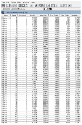
The spatial composition theory is a methodology used to describe and analyze the formal composition of the axes of urban urban projects and the social logic of space. It was developed by Heller. Its aim is to describe the method of urban formation of projects and to verify whether these projects achieve urban attraction values that are compatible with the uses of the fabric. Where movement axes maps help us. The streets are for city centers and the fabric in general with new projects in determining the most connected, integrated, control and privacy roads, and thus the most attractive ways in terms of use, access and vitality. Axial maps are drawn by the (ArcGis) program, and measures of integration, connectivity, control and privacy are calculated to understand the relationship between the residential project and the city and the project with the neighborhoods, the method of working within the space installation program with the google map program, where the main and secondary axial lines are drawn in visual and kinetic steps within the same axis. Thus, the axis is analyzed within 3 levels from highest to lowest, and each level can be distinguished by a specific color and thickness within the map. The percentages that the program measures within the indicators differ, ranging between (0-15). This is with regard to the unilateral indicators (integration, control, and connectivity). As for the binary indicators, their percentages are measured in a relative manner, ranging between (0-1). These indicators include (privacy, sensitivity, and clarity) and are in the form of charts. The most important indicators of the program can be explained as follows:
Public and private integration: refers to the interdependence between the project’s kinetic axes and the nature of its attractive foci and residential buildings. This is on the private level. As for the general level, it refers to the interdependence between the project and the axes leading to it from the city center and the connecting streets. Between the project and the neighborhoods and the attractive external foci. The indicators are measured according to kinetic and visual steps at a certain depth, and in rates ranging from (0-2) in general within the residential projects whose texture is characterized by an engineering nature.
Connectivity: Refers to the connection with the number of movement lines and roads that are directly or indirectly linked with the project being analyzed and the external attractive foci in general and with the foci within the project in particular. The ratios range between (1-9) within residential engineering projects planning.
Control: This indicator refers to the amount of control of the private axes close to the project and the extent to which they achieve privacy and security for the residential project. The control at the level of the project is the same over and over again at the level of the project with the city. Its proportions within the engineering fabric are weaker than it is within the organic tissue. The geometric fabric is characterized by the abundance of intersections and its straightness.
Privacy: This indicator is measured by integrating the two elements of integration with control at the part level. Privacy is at the level of the project with the neighbors and at the level of the parts of the project itself. Usually, the privacy ratios within the engineering fabric are less than the organic fabric due to the lack of intersections in the organic fabric and the large number of zigzags. The percentages of control and privacy are high in the old areas, unlike what they are in the modern ones.
Clarity and attractiveness of the place: It is measured through the integration between the two elements of integration and communication. Whereas, the residential environment has an engineering texture that provides attractive visual ends. In addition to the nature of the site, the residential project that is compatible with the uses of the land and is linked with the neighborhoods and the city provides clarity within the city in connection with the movement axes. Thus, it achieves attraction for easy access to it from the main axes. The result of the measurement is graphically and at rates ranging from (0-1).
Sense of place: This indicator is measured by integrating the terms clarity and privacy. The design that achieves points of attraction within the environment that you reach from multiple axes. in a kinetic and visual way, and achieves privacy for the residents of the place on a residential level in a hierarchical manner. Thus, it achieves a sense of place for the residents. The measurement results are in the form of graphs and their ratios range between (0-1).
2.3.2 The selected sample Al-Amal housing project in Basra-Southern Iraq
(1) The location of the city of Basra
Basra is located in the far south of Iraq on the western Shatt al-Arab, which is the water crossing consisting of the confluence of the Tigris and Euphrates in Qurna, 110km north of the city of Fao, the city of Basra is approximately 55km away. Kilometers from the Arabian Gulf and 545km from the city of Baghdad. It has international borders with the Kingdom of Saudi Arabia and Kuwait to the south and the Islamic Republic of Iran to the east. The local borders of Basra Governorate share with each of the governorates of Dhi Qar and Maysan in the north and Muthanna Governorate in the west. Basra is Iraq's only port and its main sea port. As in Figure 2.
Figure 2. The location of the city of Basra in relation to the Persian Gulf and Iraq
The city of Basra is the third largest city in Iraq. It is characterized by a rapidly increasing population, which is offset by a severe shortage in the number of housing. As a result of the urgent need to settle the population, control the random spread, and end the phenomenon of slums in the center, the central government in the city contributed to opening the door for investment in front of companies to build Residential cities attract residents to it through a set of attractive values. Among these cities is the residential hope that was elected to be the research sample.
(2) Al-Amal residential city in Basra
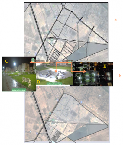
The Al-Amal housing project is considered one of the successful housing projects in Basra, especially since many projects are lagging behind due to circumstances outside the will of the investor. Anwar Al-Ibtisama Company is working on implementing it, next to the Sports City. With 780 housing units and other horizontal units with an area of 71 apartments, in addition to apartments distributed over 36 buildings with four floors, with a total of 458 apartments. It also contains schools, kindergartens, modern markets, a health center and a commercial mall “it is 7km away from the city center of Basra, an important location in Basra Governorate, as it adjoins the sports city from the northwestern side and overlooks the coast of Shatt al-Basra from the southwestern facade of Basra. It is also located on flat land and near the Sports City, the International School and Shatt Al-Arab, which are considered as attractions”.
Figure 3. (a) A network of axes and its connection to the mother city. (b) A network of internal axes of the projtheir. The source is the researcher, based on satellite images and the plans of the municipality of Basra. (c), (d), (e) The location of the outposts in relation to the project
The project attracted a large proportion of the city’s population as a result of the services in it, in addition to the presence of a multi-use attraction within the project, as in Figure 3(c), Figure 3(d), Figure 3(e), in which most of the daily and seasonal interventions are made by the administration or residents, and as a result of the great demand, investors contributed to increasing the attractive values to increase stability in it Many investors followed the intervention strategy with different mechanisms, including juxtaposition.
(3) The network of axes
The fabric of the residential city of Al-Amal with the neighborhoods and the center of the mother city in terms of formation. Streets are the most stable element of the other elements. They provide easy and speed of access in addition to being more resistant to crises over time. The study area is distinguished by its regular, functional network fabric and a clear hierarchy according to architectural importance It contains main and secondary roads, including local or secondary roads (within the residential project). The above can be illustrated through Figure 3. In general, we notice that the network of axes surrounding the project tends to be geometric, because the residential city and its neighbors are among the areas of expansion planned by the Municipalities Department of Basra Governorate. As for the network of axes towards the mother city, it is characterized by meandering and slanting due to its proximity to rivers and their parallels to them. The required plans, research, and graphs were collected. From the Basra Investment Commission, while the satellite charts were from the Google Map program. In addition to the use of the viewpoints of the specialists through a questionnaire form developed for them to inquire about the most important attractive factors in residential projects, in addition to personal interviews with the Investment Commission of the Al-Amal housing project and the engineers working in it.
2.3.3 Comprehensive evaluation
After analyzing the case study, exploring the indicators, and with the help of the results of the questionnaire and personal interviews, the evaluation will be made based on the extent to which those extracted indicators have been achieved or not. To test the research hypothesis, we proposed weighted values ranging between (2) for the achieved indicator, (1) for the partially achieved indicator, and (0) for the nonexistent pointer. The evaluation results were developed according to what is shown in Table 2. The results of the analysis varied according to the preferences of the investors and according to the desires of the population according to age, gender, culture, education and others.
3.1 Indicators of the compositional analysis of the program (ArcGis)
Using the structural analysis program to analyze the study area with the neighborhoods and with the mother city (we chose the main and secondary axes) of the region due to the large number of axes in the region and the difficulty of the program accommodating a large number of them, and this in turn affects the percentages read from the program. By measuring the network of axes, the most important findings of the analysis can be clarified as follows:
Connectivity: By analyzing the axes network of the study area with the neighborhoods and with the city center, it was found that the project’s connectivity with the mother city ranged between (1-3), while the highest connectivity ratio was (7-9), as shown in Figure 4. As for the project’s connectivity with the neighborhoods (residential areas and hotspots of the sports city, the international school, and the Julphar saliva city), the ratios ranged between (4-6), i.e., in a good way compared to the above. While the proportions of the parts of the project were connected to each other in good proportions that ranged between (6-5). That is, the start at the level of the part achieved high communication rates, and this reinforced the stability of the population in it for easy access to most parts of the project. Followed by the connection ratio with the neighborhoods up to the city center occupied the lowest percentages. It can be read that the hierarchy indicates that communication is less as it moves away from the city center and reaches. The highest values are near the study area ….
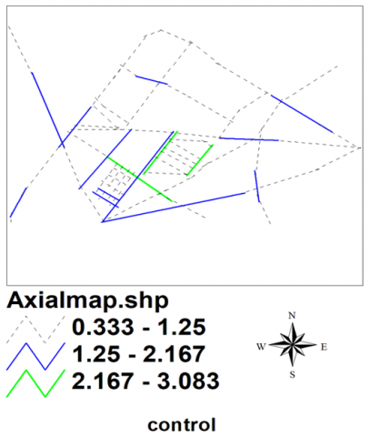
Control: The results of the analysis showed that the structural control of the project axes is relatively weak as a result of the number of intersections, with the exception of the axes close to the internal hotspots (cultural and recreational areas), where the control ratios ranged between (1.25-2.16), while the highest value was (3.08) as shown in Figure 4. While the kinetic axes of the neighborhood with the project were dominated by values (2.16) shown in blue in Figure 4. Where it can be clarified that the kinetic axes within the parts of the project were controlled by the juxtaposition of smart digital monitoring techniques that compensated for the design defect by multiplicity of connections within the axes.
Figure 4. Space syntax for control indicator
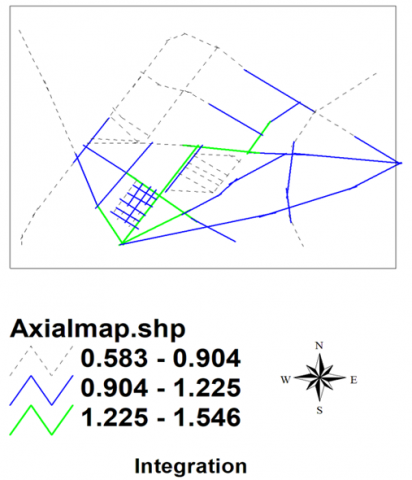
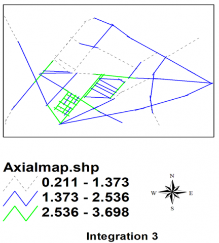
-Integration at the city level and at the level of the parts of the project with the neighborhoods: the results of the analysis showed that the integration of the project with the city was weaker than it is with the integration of the parts of the project with each other and with the neighborhoods. The highest value was the integration of the parts of the project with each other and with the neighborhoods, from the side of the residential areas and from the side of the outposts. The external attraction (the sports city, the international school, the city of recreational games, wedding halls, and car showrooms) is 3.69, which is the highest percentage in the project, so the values of integration with the city center occupied a lower value, as it was 1.37, as shown in Figure 5 and Figure 6.
Figure 5. Space syntax for integration between project and mother city indicator
Figure 6. Space syntax for integration between part of project indicator
The most important values of integration, connectivity, and control of the axes of the study area and its vicinity can be clarified through the following Figure 7 of the program ArcGis.
Through the foregoing, it was found that the results of the structural analysis within the indicators (connectivity, control and integration) that appeared in the research sample, that the achievement of these indicators in varying proportions increased the site attraction factors of the project, and therefore this is consistent with the research hypothesis. The existence of integration and linkage of the project at the level of the whole with the city and at the level of the part with the neighborhoods and between the parts of the project, in addition to controlling the axes related to the project and close to it [29].
Figure 7. All indicator of ArcView program
3.2 Indicators of integration analysis between values
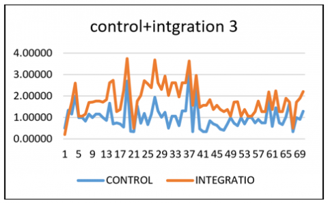
Privacy: It can be reached by integrating the values of control and integration 3, so the privacy ratios were 0.68, while the highest percentage was 0.98. This indicates good privacy achieved by the project. The following Figure 8 shows the privacy ratio. The statistical equation used by the researcher in calculating the percentages of integration of indicators is: CORREL (array1, array2). The CORREL function syntax has the following arguments: array1 Required; a range of cell values; array2 Required; a second range of cell values.
Clarity: This indicator was measured by integrating the indicators of connectivity and integration in two ways, the first at the level of the whole with the city and the other at the level of the part concerned with clarity between the parts of the project. The percentage of clarity at the level of the city was 0.67 while the highest percentage was 1, and this indicates the clarity of the project in relation to the city. It is located on a fast axis (Al-Zubair Street), which represented a high connectivity rate in the analysis of the connectivity index. The relationship can be clarified through the following Figure 9.
Clarity of the project in relation to the city. It is located on a fast aboutr Street, which represents a high connectivity rate in the analysis of the connectivity index. The relationship can be clarified through the following chart about for the clarity index measurement ratios at the level of the project parts, it was the result of merging the two indicators of connectivity and integration 3, and the ratio was 0.9, which is the highest percentage in the program. This indicates the high clarity between the project parts, as shown in Figure 10 [30-32].
Figure 8. The nature of the relationship between the indicators of control and integration to achieve privacy
Figure 9. The nature of the relationship between the indicators of connectivity and integration to achieve clarity at the city level
Figure 10. The nature of the relationship between the indicators of connectivity and integration 3 to achieve clarity at the part of project level
Finally, through the results of the structural analysis, a set of attractive values were found for the project, with rates ranging bewasn (0.6-0.9). Where the values of communication, integration, control, privacy, clarity, and sense indicated the existence of a hierarchical hierarchy between the inside and the outside and between the parts of the project itself. Whereas, the results of the sentiment index, which appeared in a good percentage, indicate the reality of the quality of the attractive residential environment and the extent of its residents' pride in it as a result of the number of events and events within the public spaces that would enhance the quality of the residential environment and strengthen social interaction, In addition to the clarity factors that have been achieved at the level of reality, as the housing project is clear at the city level because it is located on Al-Zubair Highway, which is one of the main streets in Basra, and its proximity to the Sports City and the Palm Trunk Stadium, In addition to the clarity of the elements that have been achieved at the level of the project in terms of entertainment, cultural and sports attractions. With regard to the streets and sub-axes within the project, privacy has been achieved for the resident near the residential part through organized security and digital control. This is consistent with the hypothesis of the research. The project of hope is considered a juxtaposition Positive in relation to the city and the neighborhoods, inabout areas and attractions. As for the juxtaposition of the internal foci of attraction, the axes achieved a high clarity of the internal foci of the project, and thin about is considered a positive juxtaposition at the level of the part, as well as with regard to the privacy and a sense of place, aboute good to achieve a positive contemporary juxtaposition.
3.3 A detailed analysis of the theoretical framework
Based on the theoretical framework that the two researchers reached, it was possible to analyze the types of juxtaposition mechanism and its impact on increasing and developing attractive architectural values through a descriptive form that set three criteria to verify the validity and existence of values within the residential project (realization-partial verification-unrealized) and with hypothetical ratios (2-1-0) in sequence and The statistical equation on which the researcher relied in the process of calculating percentages is (xi=xi/[xi])*100%. xi=part, [xi]=sum all .The results of the analysis were as follows.
3.3.1 Smart digital juxtaposition
The first type represents the juxtaposition mechanism, where the most appropriate achievement was 57.14%, while the partially achieved values were 42.85%. Where the first sub-indicator (smart digital technologies to achieve housing quality) achieved good rates due to the presence of advanced smart digital systems in remote electrical operation, extinguishing, refrigeration and air conditioning. Maintenance systems, firefighting system, etc. As for the second sub-indicator (presence of buildings that operate with smart digital technologies), the percentages were low due to the absence of large buildings characterized by smart digital technologies, with the exception of some cultural buildings such as the central library, a cultural entertainment building used as a hall for weddings and conferences, and entertainment buildings used for electronic sports games. As for the third indicator, it is (presence of electronic doors and control walls with smart digital systems), the percentages are high due to the presence of a smart digital system that controls the main gate of the project, which consists of the entrance door for residents, a door for visitors to enter, and a service door. The work system in it works electronically through residents’ access cards. I have sensors that indicate the opening and closing of the gate. As for the visitors’ door, their entry is through the administration’s contact with the owners of the house that the visitor wants to reach. Therefore, access roads and streets are secured with smart digital cameras that monitor the movement and entry of strangers. With regard to the service portal, it will be by giving an entry card by the administration and accompanied by a staff from the gate until the completion of the work and exit from the project. As for the use of laser lighting for advertisements or attractive lighting on tall buildings (residential apartments), the percentages were good as a result of the extensive use of laser lighting technology in advertisements for the purpose of advertising an event or occasion, in addition to the use of laser lighting on the sidewalks of streets and green areas to make attractive additions, with advertisements, animations, or landscapes. While the percentage of functional proximity index and dissolution of spatial dimensions through smart digital technologies was rather small due to its presence in a period and its absence in another period. As for the existence of smart digital technologies that enhance the principle of housing, work, entertainment and shopping within the residential environment, the values were high for their continuous existence at the present time as a result of the presence of the Internet everywhere, the need for the existence of a multifunctional virtual environment in the dwelling increased after the Corona pandemic. By describing the results of the practical study and its indicators, it was found that the presence of digital technologies and buildings would enhance keeping pace with development through the speed and accuracy of achievement, achieving security and privacy in aesthetic and functional forms, in addition to providing digital job opportunities within multiple locations and hotspots that would increase attractive values and thus enhance housing stability over time.
3.3.2 Ecological juxtaposition
The analysis method of the study area of ecological juxtaposition indicated that there is an integrated percentage about the presence of ecological juxtaposition in part, and this is what is found in the project, where the percentage of partial juxtaposition reached 100%. The most important partial indicators of ecological juxtaposition can be clarified, with regard to the first partial indicator of the juxtaposition mechanism, which is the presence of corridors water and green spaces near the walkways were an average achievement rate, as they are found in places and not found in others. In addition to the lack of numbers of green spaces near the walkways, investors attribute the reason to the hot, dry climate of the city of Basra that needs special plants that bear such atmospheres, and methods of obtaining resistant plants require politeness large, the most important of which is the water free of salts, and in general the Basra Governorate, in the last 4 years, there is almost no potable water due to the drought of the Shatt al-Arab water level. As for the second sub-indicator, which is the ecological character, the ratios were also medium as a result of the presence of continuous interventions to invest the residential facades by activating the ecological character during the spring of the year. Because the people closed the open spaces to be used for other residential functions, and this would reduce openness in general to the outside. It can be clarified that the idea of ecological urbanization in the city of Basra at the present time is considered one of the ideas that is difficult to implement in a flexible manner, and the reason is due to several factors that contribute to the problem, including the harsh climate, unhealthy water and inappropriate soil, in addition to the ideas of the community that encourages the exploitation of the largest possible amount of space in building instead of it in green and blue spaces. Even if there are green spaces, then it is one of the ideas for unsupervised future expansion. In addition to the above, the lack of control and lack of responsibility on the part of the Investment Authority and its lack of interest in urbanization only Ecology (the absence of any explicit text regarding green or blue spaces and their expansion). All these factors have contributed so far to obstructing the development of ecological inclusion.
3.3.3 Architectural juxtaposition
Onsidered the most diverse and attractive type of juxtaposition mechanism, as this type expresses the external and internal form of the project in addition to the nature of the project in relation to the mother city and in relation to the neighborhoods. Whereas, the contemporary residential project in itself is considered an architectural juxtaposition in relation to the city in the event that communication, integration, control, sense and privacy are available, it is considered interpolation Positive architectural interpolation. As for the opposite, it is considered a negative interpolation. Through the use of the structural analysis program for the project, the ratios indicated that the project (residential hope) was a positive architectural interpolation as a result of the good proportions that the project achieved at the level of the whole (the project, the city and the neighborhoods) and at the level of the part (the nature of the relationship). As for the descriptive analytical questionnaire, the proportion of architectural juxtaposition achieved in a total way was 52%, while it was partially achieved, it was 36%, while the unrealized, it got 10%. Turning to the partial indicators of architectural juxtaposition, we find: construction, so the executing company used building materials that reduce the temperature and followed dyes in light colors that take into account the nature and climate of Basra. It is easy to maintain and clean, in addition to its local availability and low cost. At the same time, simple forms were used that achieved aesthetics at the local level. While the partial indicator that deals with the presence of multi-use spaces with different activities was obtained, its proportion was good as a result of the availability of public spaces and spaces used for recreational, cultural, health, educational and social purposes. At the same time, the daily and seasonal interventions are raised. As for the existence of methods and methods of linking between the built and non-built space, the investing administration has tried to invest such an intervention by linking the spaces with a network consisting of solar panels to invest solar energy, but so far the method is under implementation. As for the architectural juxtaposition of architectural models is the presence of two architectural styles in the project, as the merger between the local and wild styles in shapes and designs with events, spaces, and the nature of global external life, such as activating periods, feasts, and international occasions, and the use of tools and details in a noticeable way within public spaces and with the wide participation of the population, contributed to increasing the attractive values of the place. Partial indicator is the existence of swimming activities, sports centers and a bed It has a high proportion of its existence and advanced technologies, as the presence of small sports stadiums that operate as sports schools motivate children and youth of different ages, and at the end of the season a group of them is nominated to represent Iraq’s teams of various ages, and these football schools are sponsored by locally known coaches and registration is exclusively for the project’s residents. It has training and development courses at a rate twice a year during school holidays. As for the insertion of attractive structures and formations within public spaces, it has obtained good rates as a result of its availability in a clear manner through the insertion of kiosks and monuments in shapes symbolizing the city of Basra and using materials symbolizing Shanashil (the old city of Basra). In addition to the presence of reading spaces and a library within the public spaces, and umbrellas for holding family events and encouraging social interaction. These areas are secured with security personnel, surveillance cameras, and service and maintenance workers throughout the day. This in turn achieves the last partial indicator by providing security for public areas.
Finaly, it can be concluded that the presence of more than one type of juxtaposition mechanism in varying proportions has achieved a residential attraction and enhanced the population stability in the place. In addition to that, there are continuous attempts by the project investors to provide continuous interventions that increase the attractive values and achieve a positive reputation for the place and management, and thus increase investment competitiveness.
The project is considered a positive juxtaposition of the region because of the values of integration and communication it has achieved with the mother city and with the neighbors and the internal and external attractive core. Through the foregoing, it can be stated that the urban juxtaposition is considered the most widespread compared to the ecological and digital one as a result of the presence of many companies that invest in it. In addition to developing urbanization ideas in a flexible manner in order to enhance the urban reality to create an attractive residential scene, being the first thing that the eye sees when acquiring housing in aesthetic forms and multiple functions. Thus, the research sample achieved many patterns of urban juxtaposition in a manner commensurate with the nature of life and the desires of the population, as the integration of patterns of juxtaposition mechanism in varying proportions would generate attractive urban values in the project, and this is consistent with the research hypothesis.
4.1 Conclusions
In general, the residential project mainly consists of residential buildings, services, open spaces, green areas, and a network of axes, all of which are interconnected as an integrated and flexible system. Residential projects can be invested in a set of interventions that achieve attractive values at the beginning of the project’s establishment, and the continuation of the interventions enhances the development of values and enhances the stability of its residents. Intervention strategy within a group of mechanisms, including the juxtaposition mechanism. The juxtaposition represents several patterns that support buildings, activities, spaces, and axes, and the idea of its continuation depends positively on developing attractive values, keeping pace with development, and reducing societal, local, and global differences. Different periods of time or different intellectual references within a residential environment that merge with the context and the site formally or spectrally, or contradict in a positive manner that creates distinction and visual pleasure. control, integration, diversity, privacy and clarity), which in turn determine the nature of juxtaposition, positive or negative, and have you achieved the development of the attractive architectural values represented by the residential landscape, the residential environment and the architectural styles). With regard to the practical study, the research proved several aspects, including:
§ 1- The juxtaposition mechanism achieves the stimulus for renewal, development, and flexibility to reorganize the space or the residential building through the introduction of new advanced uses that advance the housing reality, encourage stability, and increase and develop attractive values.
§ 2- The research proved that the residential project that achieves the most attractive values within the same residential environment creates aesthetic diversity and functional diversity within one space, which increases use and then enhances the sense of place and increases housing stability.
§ 3- The research concluded that the location of the housing project in relation to the mother city has a significant impact on the promotion of juxtaposition, so the project's achievement of integration and interdependence with the fabric and with other land uses is considered a positive juxtaposition within the urban environment and thus achieves public attraction.
§ 4- Urban values are considered the most important values for development from the viewpoint of residents and specialists because they are the basis of stability. The juxtaposition mechanism has an impact on development.
§ 5- Governmental interventions within the housing project have a significant impact on increasing residential demand due to the availability of public participation in providing and facilitating access roads and public services, in addition to future security as public possession.
§ 6- The results of the practical study through the arcgis analysis program and the detailed analysis according to the reality of the situation in the project were consistent with the research hypothesis, and therefore the project achieved attraction before the works as a result of good advertising and marketing, and the attraction increased after the works as a result of continuing to increase the attractive values.
4.2 Recommendations
The research recommends the following: 1- Taking advantage of the theoretical model to enhance the indicators of the development of attractive urban values for residential projects through the patterns of the juxtaposition mechanism, which are completely as the intersection of buildings or spaces or in part by the intersection of events or activities within buildings or systems. 2- Focusing on government support for residential projects, which provides attractive values for them through the development of regulations and laws that oblige investors to continue with intervention strategies to ensure the durability and attractiveness of residential projects and keep pace with global development. 3- Attention to continuing the intervention strategy at the level of residential projects to reduce the differences, improve the deteriorating housing reality, and build a life that achieves comfort and luxury and work within the same residential environment, by diversifying interventions during the life of the project from the period before the occupancy until during the occupancy period and after the occupancy. 4- The use of modern technologies with an intervention strategy (such as digital and ecological technologies) that will speed up work, tighten it and keep pace with development. A flexible housing project that is resistant to crises can be achieved by finding quick solutions and advanced technologies.
5.1 Future research prospects
The research in this paragraph presents a number of research proposals:
• The role of the juxtaposition mechanism in the development of future housing values.
• The impact of the intervention strategy on increasing the economic attractiveness of housing projects.
• The role of positive juxtaposition in reducing neglected housing advances.
• Temporary intervention strategies within residential projects.
• Official intervention strategies and their impact on increasing housing stability.
• The role of integration and communication in the residential fabric in increasing the attractive values. The Narjis project in Basra is a case study.
• The depthmap program can be as a methodology used to measure integration, connectivity, interdependence and control in any new housing project.
5.2 Beneficiaries
§ All Architectural Engineering departments;
§ Department of Urban and Regional Planning-University of Baghdad;
§ Basra Investment Commission;
§ Basra Municipality Directorate-Basra Governorate;
§ Municipalities Directorate in the governorates;
§ Ministry of Construction and Housing;
§ Architectural government institutions-scientific research institutions National Investment Authority.
5.3 Final massage
The importance of the research crystallizes from the growing importance of contemporary housing projects and their role in creating a stable environment with close interdependence of its inhabitants among themselves on the one hand, and with it on the other hand depending on an integrated, ever-evolving value system over time that simulates social, cultural and economic developments and multiple needs as a basis for the success of these projects and a guarantor of their permanence and continuity. Norman Foster says that buildings are an expression of values. And that the difference between architecture, building, good environment and bad environment is the time you spend in it (David Cheer field). The importance of research can be described from the importance of housing with attractive values. It is a dialogue between the architect and the client to talk about dreams (Robert A.M. Stem).
[1] CABE. (2005). What home buyers want: Attitudes and decision making among consumers. Commission for Architecture and the Built Environment. https://www.mae.co.uk/assets/pdfs/151123_Mae_Architects_What_Home_Buyers_Want_Housing_Architecture.pdf.
[2] Dictionary, B. (2012). Business dictionary.
[3] Hyungun, S. Sugie, L., SangHyun, C. (2015). Operationalizing Jane Jacobs’s architectural design theory: Empirical verification from the great city of Seoul, Korea.
[4] UN-Habitat. (2013). A new strategy of sustainable neighborhoun-habitat. http://unhabitat.org/wp-content/uploads/2013/05/5-Princthe iples web.pdf.
[5] Michael F., Miles, K. (2009). Interactive Architecture. Princeton Architectural Press.
[6] King J., Perry, C. (2017). Smart buildings: Using smart technology to save energy in exsting buildings. ACEEE American Council for an Energy-Efficient Economy.
[7] Izmir, G. IIan K., Bruce, J. (2009). Neighborhod and community centers: Results for children families and communities. Social Policy Research Centre, University of New South Wales.
[8] Kempen, R., El Atmani, D. (2013-2017). Governing architectural diversity: Creating social cohesion, social mobility and economic performance in today’s hyper-diversified cities. Journal of Urban Planning, 45(3): 123-145.
[9] Keshtkaran, R. (2019). Architectural landscape: A review of key concepts and main purposes. International Journal of Development and Sustainability, 8(2): 141-168.
[10] Tang, Y., Gao, C., Wu, X. (2020). Urban ecological corridor network construction: An integration of the least cost path model and the InVEST model. ISPRS International Journal of Geo-Information, 9(1): 33. https://doi.org/10.3390/ijgi9010033
[11] Thomson, G., Newman, P. (2021). Green infrastructure and biophilic archiarchitecturalools for integratinresource resource-efficient logicalal cities. Architectural Planning, 6(1): 75-88.
[12] El-Darwish, I.I. (2022). Enhancing outdoor campus design by utilizing space syntax theory for social interaction locations. Ain Shams Engineering Journal, 13(1): 101524. https://doi.org/10.1016/j.asej.2021.06.010
[13] Zehawi, R.N., Hameed, A.H. (2022). The impact of urban growth pattern on local road network: A system dynamics study. International Journal of Design & Nature and Ecodynamics, 17(2): 221-231. https://doi.org/10.18280/ijdne.170208
[14] van Nes, A., Yamu, C. (2017). Space syntax: A method to measure urban space related to social, economic and cognitive factors. In the Virtual and the Real in Planning and Urban Design. Routledge, pp. 136-150.
[15] Mugnano, S., Palvarini, P. (2013). Sharing space without hanging together: A case study of social mix policy in Milan. Cities, 35: 417-422. https://doi.org/10.1016/j.cities.2013.03.008
[16] Wijesundara, J., Wijekoon, N. (2017). Transitory urban interventions for effective place making in shopping streets: Case of pettah in Sri Lanka. Cities People Places: An International Journal on Urban Environments, 2(1): 10-25.
[17] Khalil, M., Eissa, D. (2013). Reclaiming residual spaces for the public: A case study from the city of Cairo. In Proceedings of the International Conference on Cities, People and Places-Colombo, pp. 105-121.
[18] Mike, Y., Dan, B., Tony, G., Russ, P., Ronald, W. (2012). Tactical architecturalism short-term action long-term change volume 2. The Street Plans Collaborative.
[19] Moore-Cherry, N. (2017). Beyond art in ‘meanwhile spaces’: Temporary parks, urban governance and the co-production of urban space. The Impact of Artists on Contemporary Urban Development in Europe, 207-224. https://doi.org/10.1007/978-3-319-53217-2_9
[20] Elmestikawy,H. (2008). Juxtaposition. Retrieved from arttalks, https://arttalks.com/exhibition/juxtaposition/
[21] ExpertPhotography. (2021). Best juxtaposition photography examples. ExpertPhotography. Retrieved from expertphotography.com
[22] Muscato, C. (2020). Juxtaposition in architecture. Colorado: Study.ac Academy.
[23] Küçük, M., Arslan, H. (2020). Investigation of diagrid structures over gherkin tower. In Proceedings of the 3rd International Conference of Contemporary Affairs in Architecture and Urbanism (ICCAUA-2020), Alanya, Turkey, pp. 6-8. https://doi.org/10.38027/N12020ICCAUA316291
[24] Mandal, S. (2022). Reinventing architectural dynamics as an individual architect. Thinking the Future.
[25] Jørgensen, O., Hinners, S. (2018). Mapping and measuring the architectural wildland juxtaposition. Center for Ecological Planning and Design, p. 3.
[26] Skylum. (2021). Top secrets of juxtaposition in photography revealed.
[27] Szabó, M. (2018). The regional development of democratization and civil society: Transition, consolidation, hybridization, globalization-taiwan and hungary. Przegląd Politologiczny, (4): 153-172.
[28] Warfield, A. (2020). Juxtaposition. Retrievefromom storyboardhatt, https://www.storyboardthat.com/ar/storyboards/anna-warfield/juxtaposition-examples
[29] Hasan, N.A. (2022). The swarm city-characteristics of the swarm intelligence system in the traditional Arab city. International Journal of Design & Nature and Ecodynamics, 17(1): 17-28. https://doi.org/10.18280/ijdne.170103
[30] Mahdi, R.M., Al-Kaissi, K.A. (2020). Active housing design that supports health. IOP Conference Series: Materials Scienceand Engineering, 870: 012009. https://doi.org/10.1088/1757-899X/870/1/012009
[31] Hasan, N.A. (2020). The spatial organization strategies of productive cities. IOP Conference Series: Materials Science and Engineering, 881: 012021. https://doi.org/10.1088/1757-899X/881/1/012021
[32] Khalaf, M.A., Rasheed, K.G., Mahdi, R.M. (2023). Strategy of active housing. AIP Conference Proceedings, 2651: 020061. https://doi.org/10.1063/5.0105803