Andy Fefta![]() | Fadly Usman*
| Fadly Usman*![]() | Agus Dwi Wicaksono
| Agus Dwi Wicaksono![]() | Dadang Meru Utomo
| Dadang Meru Utomo![]() | Keisuke Murakami
| Keisuke Murakami![]()
© 2023 IIETA. This article is published by IIETA and is licensed under the CC BY 4.0 license (http://creativecommons.org/licenses/by/4.0/).
OPEN ACCESS
The Internet has increasingly become a critical part in digital era, the Internet has changed how we interact through social media, access information and public services, and navigate spatially. This article argues that adopting a Smart City concept to meet the needs of urban residents should be done in a careful and sustainable manner. Using the city of Malang in the East Java Province as a case study, the research employees a spatial of SWOT analysis, Pentagon Assets Analysis, and 3D IPA. The results showed a disparity of Internet access amongst Malang City residents. The Pentagon Assets results identified that the residents’ social and financial capital is still conventionally trying to fulfill their basic needs. Likewise, the spatial SWOT analysis showed that the Internet coverage area was still constrained by the infrastructure network and basic urban infrastructure. This was also supported by the results of the 3D IPA analysis, which showed that most residents have not received good and proper internet network services. The paper offers several public policy implications in the context of the Smart City development. It concluded that policymakers should consider several aspects such as fulfilling basic urban services, increasing community capacity, or fulfilling Smart City development.
smart city, spatial SWOT analysis, Pentagon asset, 3D IPA, public policy management
A Smart City is a city that uses digital technology to improve its services to the community, reduce costs and consumption of commodities, and more actively and effectively engage with its citizens [1]. At least three factors influence smart cities: economic intelligence, social intelligence, and environmental intelligence [2]. Smart City is also defined as a city that can use human resources, social capital, and modern telecommunications infrastructure to realize sustainable economic growth and high quality of life, with wise resource management through public participation-based governance.
The Smart City concept was created by the International Business Machines Corporation (IBM). Previously, various names like digital City or Smart City were discussed by world experts. In short, a Smart City is a city whose instruments are interconnected and function intelligently. Smart City is a concept that helps its residents manage existing resources efficiently and provide the correct information to the community to carry out their activities or anticipate unexpected events. The Smart City concept generally includes:
1) Performs well with consideration to the economy, people, governance, mobility, and the environment. 2) Control and integrate all infrastructure in urban areas. 3) Connecting physical infrastructure, IT infrastructure, social infrastructure, and business infrastructure to increase city intelligence. 4) Make cities more efficient and livable.
Based on the definitions above, several technical approaches were carried out to assess the readiness of Malang City in implementing the Smart City concept. One of the assessments is by using a Spatial SWOT Analysis, Pentagon Assets, and 3D IPA. The Spatial SWOT Analysis is used to assess the city’s readiness based on the space availability in Malang City. In contrast, the Pentagon Asset is used to assess the community’s readiness in facing the Smart City. The 3D IPA is an analytical tool used to evaluate the gap between the services provided by the government and the level of importance based on Malang residents.
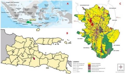
Figure 1. Map of Malang City in Indonesia; (A) the position of the East Java Province in Indonesia (B) the position of Malang City in the East Java Province, (C) the land use map
This study aims to determine the readiness of Malang City and its residents to implement the Smart City concept. The combined spatial analysis, social analysis, and public perception are hoped to become a tool for policymakers for public policy management. Malang City is located in East Java Province, Indonesia, and is the second-largest city in East Java after Surabaya and the 12th largest city in Indonesia. The city, founded during the Kanjuruhan Kingdom, is located in a highland area of 145.28 km² in the middle of Malang Regency. Figure 1 above shows the orientation of Malang City in Indonesia.
Internet of things is a concept where an object can transfer or transmit data over a network without computer and human devices. The internet of things, often referred to as IoT, is currently experiencing many developments [3]. IoT development can be seen from the level of convergence of wireless technology. Additionally, many technologies have implemented IoT systems, for example, motion sensors, light sensors, and sound sensors from the latest Google technology, Google artificial intelligence, and Amazon Alexa.
Smart City is a city area that has integrated information and communication technology in daily governance to increase efficiency, improve public services, and improve the welfare of citizens [4]. Furthermore, most recently, the implementation of Smart City has been carried out in several developed countries, such as China and Germany. Thus, all forms of residential activity can be appropriately monitored by a system with a large-scale database network. At least five elements of IoT make up the internet and smart cities, including artificial intelligence, connectivity, small size devices, sensors, and active engagement [5]. Here is the description: (1). Artificial Intelligence (AI) provides the ability for any technology or machine to think. Thus, AI is done by collecting data, installing networks, and developing algorithms from artificial intelligence. In the past, machines could only carry out commands from the user directly; now, they can carry out various activities independently without waiting for instructions from the user. (2). Connectivity is a connection between networks. In an IoT system consisting of small devices, each system will be interconnected with a network to create a more effective and efficient performance. The standard network installation costs do not always require an extensive network and considerable expense; device systems using simpler networks at a lower cost can also be done. (3). Small size devices. A smaller device will result in fewer costs in today’s technological developments, but the effectiveness and scalability are high. Thus, humans can more easily use IoT-based technology devices comfortably, precisely, and efficiently in the future. (4). Sensors help differentiate IoT from other sophisticated machines. Sensors make it possible to define an instrument that can change IoT from a standard network that tends to be passive to an active system integrated with the real world. (5). Active engagement, many modern machines still use passive engagement. However, unlike other machines, IoT has implemented an active paradigm in various content, products, and services.
The level of consumer satisfaction or dissatisfaction results from differences between consumer expectations and the performance perceived by these consumers [6]. The satisfaction index is used to measure how customers are satisfied with the services they receive. According to research of Asep Saifuddin [7], the Importance-Performance Analysis (IPA) can be used to measure the level of various elements of a collection of services and identify the necessary actions. Martilla and James suggest using the Importance-Performance Analysis method in measuring the level of service satisfaction [8]. In this method, it is necessary to measure conformity to determine how satisfied customers are with the company’s performance and how much the service provider understands what customers want for the services they provide [9].
Albino et al. [11] in their research said that Smart Cities will increase the performance of city, not affected by the coverage area, distance and dimensions of the city [10]. Internet-based trips for urban residents such as smartphone applications with GPS will also increase the efficiency and effectiveness of urban residents. But how and what makes a city smart? Identifying core components and proposing an integrative and comprehensive conceptualization are very important [12].
With the variables of urban infrastructure and community readiness, the smart city concept can be realized more realistically [13, 14]. In this research, participatory mapping for community empowerment will have an impact on the assessment of community needs and support from the government [15]. Li et al. [16] said in his report about the concept, key technologies and applications of temporal–spatial information infrastructure, geo-spatial analysis will provide an overview of how capable the city in preparing itself to support the smart city concept. Like two sides of a coin, not only about city infrastructure in developing a smart city but also the readiness of the people to use it. Understanding commuting patterns needed to analyze community preparedness in utilizing internet technology in smart cities [17].
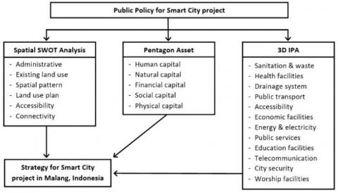
Several stages and analytical techniques are carried out in this study. The long duration is affected by the many social parameters used to assess technical parameters related to the city’s readiness to implement the Smart City concept. For this reason, it is necessary to understand several essential attributes and variables in realizing a Smart City, including community readiness, supporting infrastructure readiness, and urban area readiness.
Figure 2. Research analysis diagram
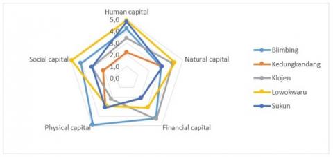
Analysis technique in research is by quantitative analysis, divided in three parts of analysis: (1) spatial analysis, (2) pentagon asset analysis and (3) 3D Importance Performance Analysis as seen on Figure 2. Spatial analysis to understand the readiness of city infrastructure to support smart city concept. To assess the readiness of Malang residents regarding IoT in a Smart City project in Malang City, several assessments were carried out using the Pentagon Asset Parameter, namely human capital (level of education, skills and training), natural (availability of land area), financial capital (income per capita, livestock owner, and saving), physical capital (medical facility, access road and infrastructure), social capital (key persons and culture) [18]. This assessment is expected to provide an overview of the readiness of individuals in a sub-district to ensure they can realize their potential as productive members of the community [19]. The assessment was carried out on 3,525 respondents in 5 different sub-districts in Malang City, namely Blimbing, Kedungkandang, Klojen, Lowokwaru, and Sukun. The number of respondents was taken from around 5% of the productive age population in each sub-district of Malang City, as shown on Table 1 below.
Table 1. Population of Malang city in 2021 and respondent
|
Sub District |
Total population |
|
|
2021 |
Respondent |
|
|
Klojen |
94,072 |
415 |
|
Blimbing |
182,504 |
750 |
|
Kedungkandang |
208,075 |
850 |
|
Sukun |
196,487 |
835 |
|
Lowokwaru |
163,795 |
675 |
|
MALANG CITY |
844,933 |
3525 |
The Pentagon Asset Analysis assessed community capacity through five parameters, namely; 1) Human Capital, which includes Health, Education, Knowledge and Skills, the capacity to work and adapt. 2) Natural Capital includes; Land and its production, water and water resources such as fish and marine products, trees, agricultural commodities, plants and forest products, game animals, uncultivated fiber and food, biodiversity, and activities related to the environment. 3) Financial Capital, namely; Savings, pension funds, business profits, wages or salaries, and other assets such as stocks, crypto, and other assets. 4) Social Capital namely; Networks and connections, harmony between neighbors, good relations with friends, relationships based on mutual trust, and mutual support in formal and informal groups. 5) Physical Capital includes infrastructure in transportation networks, vehicles, public transport, buildings and residences, sanitation facilities and clean water, energy, communication networks. Other crucial physical capital in today’s digital era is technology support and tools such as equipment for production, seeds, fertilizers, pesticides, traditional technology, and communication technology. All are connected in a good information system. Meanwhile, to measure the readiness of Malang City in implementing a Smart City, a 3-Dimensional Importance-Performance Analysis is used. Some of the attributes assessed in this analysis include the readiness of urban infrastructures such as sanitation, waste management, health facilities, drainage system, public transport, accessibility, economic facilities, energy, public services, education facilities, telecommunication, city security, and worship facilities.
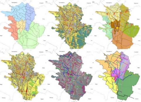
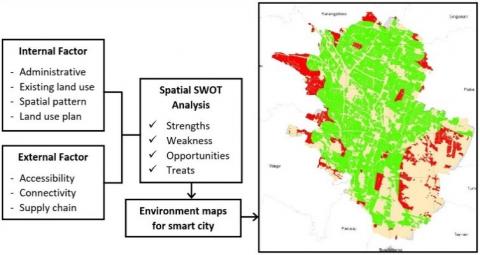
Several essential thematic maps are used to perform a spatial SWOT analysis, including administrative maps, existing land use, spatial patterns, land use plans, accessibility, and connectivity. The analysis showed the internet coverage area for connectivity needs and the feasibility of Malang City to become a Smart City to provide a community service facility in urban areas [20].
In this study, the Pentagon Asset Analysis uses livelihood asset parameters. Livelihood can be interpreted broadly [21]. Livelihood can also be defined as the efforts people conduct to earn income, including their capabilities, quantifiable assets such as availability and resources, and non-quantifiable assets such as claims and access. The Pentagon Assets referred to in this study are human capital, natural capital, financial capital, physical capital, and social capital [22, 23].
As mentioned earlier, this study uses three types of analysis to implement public policy management related to developing the Smart City concept in Malang City. The SWOT analysis is closely related to external factors and internal factors. The spatial analysis in urban areas focuses more on the city’s existing conditions, such as land use, natural conditions, climate and weather, and urban land-use plans based on the direction of the city government.
Figure 3. Thematic maps used in the spatial SWOT analysis
Figure 4. The spatial SWOT analysis
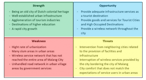
The internal factors in this study are the built environment factors, while the external factors are the distribution of goods and accessibility to and from the city [24]. Figure 3 describes the thematic maps used in this study: administrative maps, existing land use, spatial patterns, land use plans, accessibility, and connectivity. For developing a Smart City in Malang City, land use plans in urban areas, accessibility, and connectivity are critical parameters the city must own before developing a Smart City. The SWOT analysis considers four crucial aspects of the analysis process: strengths, weaknesses, opportunities, and threats [25, 26]. These aspects are placed in a matrix in the spatial SWOT analysis, as shown in Figure 4. In the development of a Smart City in Malang, the ‘strength’ include Malang City being an old city inherited from the Dutch colonial era, having a well-established urban infrastructure, being an agglomeration of tourism industries, and a destination of higher education and the rapid growth of the City.
Figure 5 is the result of a spatial SWOT analysis based on several thematic maps, which produces zones with red, green, and yellow that indicate the condition of the availability of supporting infrastructure in Malang City to develop a Smart City for residents to meet their daily needs.
Figure 5. Map overlay result of spatial SWOT analysis
In comparison, its ‘weakness’ includes having a high urbanization rate, many slum areas in urban areas, inadequate wireless service network that has yet to reach the entire Malang City area, and an unhandled road network in urban village areas by government services. The ‘opportunity’ includes providing adequate infrastructure services as a tourist destination, providing goods and services for Tourism Cities and High Occupied Destinations, and providing wireless networks throughout the city.
Table 2. Respondents recap of pentagon asset analysis
|
Capital |
Sub variables |
Sub District |
||||
|
1 |
2 |
3 |
4 |
5 |
||
|
Human |
education |
4.5 |
2.6 |
3.5 |
4.9 |
4.8 |
|
|
Skills |
4.4 |
2.0 |
3.5 |
4.9 |
4.9 |
|
|
training |
3.8 |
2.0 |
3.3 |
4.9 |
4.8 |
|
Natural |
land Area |
3.1 |
3.2 |
4.1 |
4.3 |
3.2 |
|
Financial |
Income per capita |
4.5 |
2.2 |
3.9 |
3.3 |
2.3 |
|
|
livestock owner |
4.1 |
2.1 |
4.5 |
3.0 |
2.0 |
|
|
savings |
3.9 |
2.0 |
4.4 |
3.0 |
2.0 |
|
Physical |
medical facility |
4.9 |
3.5 |
2.2 |
2.9 |
3.2 |
|
|
access road |
5.0 |
3.1 |
2.2 |
3.2 |
3.3 |
|
|
infrastructure |
4.8 |
2.8 |
2.2 |
2.7 |
2.7 |
|
Social |
key person influence |
4.2 |
2.0 |
3.2 |
4.9 |
3.1 |
|
|
culture |
4.0 |
2.2 |
3.0 |
4.9 |
3.1 |
Furthermore, the ‘threats’ include interventions from neighboring cities related to facilities and infrastructure, intrusion of wireless services provided by cities bordering Malang, and city comfort that does not meet service users’ expectations in urban areas. The existing threats may impact the quality of urban network services that wireless network services will ultimately meet in the city directly adjacent to Malang. Figure 5 is the result of spatial SWOT analysis using several thematic map data (Figure 3) and the SWOT analysis results from the data in Figure 4. The green zone shows areas in urban areas that are still served by internet facilities, while the internet quality in the red zone is an area with poor internet coverage or even without an internet network at all.
Table 2, Table 3 and Figure 6 are the result of the Pentagon Assets Analysis in 5 sub-districts in Malang City based on respondents’ answers. Each sub-district has its uniqueness; when associated with community readiness for Smart City development in Malang City, Blimbing sub-district and Lowokwaru sub-district are the most prepared based on the assessment of human capital, natural capital, financial capital, physical capital, and social capital. Kedungkandang sub-district is the least prepared based on the assessment of the variables mentioned above.
Table 3. The results of pentagon asset analysis
|
No |
Sub-Distict |
Human capital |
Natural capital |
Financial capital |
Physical capital |
Social capital |
Capacity |
|
1 |
Blimbing |
4.2 |
3.1 |
4.2 |
4.9 |
4.1 |
20.5 |
|
2 |
Kedungkandang |
2.2 |
3.2 |
2.1 |
3.1 |
2.1 |
12.7 |
|
3 |
Klojen |
3.4 |
4.1 |
4.3 |
2.2 |
3.1 |
17.1 |
|
4 |
Lowokwaru |
4.9 |
4.3 |
3.1 |
2.9 |
4.9 |
20.1 |
|
5 |
Sukun |
4.8 |
3.2 |
2.1 |
3.1 |
3.1 |
16.3 |
Figure 6. Spiderweb diagram of pentagon asset analysis
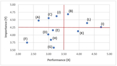
The result of an assessment of the twelve attributes used to determine public opinion on basic services in Malang City (See Table 4 and Figure 7). The IPA analysis results show that sanitation and waste, drainage, and telecommunication are attributes that need to be improved. These results are relevant to the SWOT spatial analysis which shows that internet network services have not reached all areas in urban areas. Meanwhile, the attributes of health facilities, education facilities, and worshipping facilities are considered very well from the respondent’s opinion.
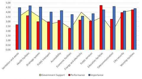
As shown in Figure 7, the gap analysis is carried out based on the data in the table and translated into a diagram in Figure 8. In Figure 8 shows how government support for each attribute of basic urban services is not sufficient, despite the people’s desire and expectations being very high for these services. For example, in sanitation and waste management services, the government pays sufficient attention. However, city residents deem the services insufficient, along with the urban drainage system, which they also deem incapable of serving the City well.
Table 4. The results of IPA from respondent
|
No |
Attributes |
X |
Y |
Z |
|
A |
Sanitation and waste |
2.67 |
4.48 |
3.50 |
|
B |
Health facilities |
3.64 |
4.69 |
4.25 |
|
C |
Drainage system |
3.00 |
4.55 |
3.50 |
|
D |
Public transport |
2.99 |
4.02 |
2.75 |
|
E |
Accessibility |
3.14 |
4.16 |
3.00 |
|
F |
Economic facilities |
2.29 |
3.75 |
2.25 |
|
G |
Energy and electricity |
3.17 |
3.58 |
4.00 |
|
H |
Public services |
3.08 |
3.84 |
3.00 |
|
I |
Education facilities |
4.72 |
4.26 |
3.50 |
|
J |
Telecommunication |
3.26 |
4.62 |
2.00 |
|
K |
City security |
3.97 |
4.13 |
4.00 |
|
L |
Worship facilities |
4.26 |
4.40 |
4.25 |
Figure 7. Cartesian diagram of IPA analysis
Figure 8. Measures value of GAP analysis
Referring to the findings of the mentioned analysis, policymakers can consider several important aspects such as fulfilling basic urban services, increasing community capacity, or improving development aspects to fulfill Smart City development. Figure 8 clearly shows the gap between the people’s desire for good telecommunications facilities, especially the internet, and the result, which the city government has not fully supported. Likewise, the spatial SWOT analysis results show that many urban areas have to receive adequate internet network services.
However, when looking at the results of the Pentagon Asset Analysis which is an assessment of the livelihood asset parameters of residents in urban areas, Kedungkandang and Sukun sub-districts are still impoverished, so they are still focused on basic needs, not focusing on the internet use to meet their primary needs, moreover to meet secondary or tertiary needs. Meanwhile, the landscape and internet network infrastructure based on the Pentagon Assets Assessment is at a level capable of meeting the community’s needs, except for the Blimbing sub-district, which has excellent internet network service and fits the expectations of its users.
Urban areas are rapidly developing, and in the digital era like now, speed and accuracy of service for the community are needed. Smart City is one of the infrastructure development plans in Malang City; however, the condition of Malang City and its residents needs to be evaluated based on the parameters of Smart City development, population readiness, and the existing condition of urban infrastructure facilities.
Based on research on the feasibility of a Smart City project in Malang City, policymakers can consider several notes. The spatial SWOT analysis shows that wireless services related to the internet network are only deemed sufficient in the central area of Malang City and linear secondary and tertiary roads. Thus, areas with inadequate internet networks, especially around the outskirts of Malang City, are left behind. The results of the Pentagon Asset Analysis also show a linear condition where the outskirts of Malang City, such as the Kedungkandang sub-district, have a low assessment of livelihood. Meanwhile, the 3D IPA analysis results, which compares the service level of urban facilities and public perceptions and government support, show that the telecommunication and internet networks aspect cannot meet users’ expectations.
It is necessary to improve services and to support infrastructure for the Smart City development in Malang City. As a tourism city and one of the destinations for higher education in Indonesia, Malang City should improve itself to enter the digital era more massively, namely by being a Smart City that can improve services for all city residents in meeting their basic needs such as education, information, online shopping, and other needs.
The author would like to express their gratitude towards Research and Community Service, Brawijaya University (LPPM UB) through the Doctoral Service program so that this research can be funded. The author would also like to recognize the help of Professor Keisuke Murakami from Miyazaki University who participated in the field survey at the research site through the Japan Student Services Organization (JASSO) research program.
[1] Ahvenniemi, H., Huovila, A., Pinto-Seppä, I., Airaksinen, M. (2017). What are the differences between sustainable and smart cities? Cities, 60: 234-245. https://doi.org/10.1016/j.cities.2016.09.009
[2] Akhtar, A., Rafiq, S., Asif, A., Saeed, A., Kashif, M. (2012). Public perceptions of police service quality: empirical evidence from Pakistan. International Journal of Police Science & Management, 14(2): 97-106. https://doi.org/10.1350/ijps.2012.14.2.266
[3] Tcholtchev, N., Schieferdecker, I. (2021). Sustainable and reliable information and communication technology for resilient smart cities. Smart Cities, 4(1): 156-176. https://doi.org/10.3390/smartcities4010009
[4] Rosa, L., Silva, F., Analide, C. (2021). Mobile networks and internet of things infrastructures to characterize smart human mobility. Smart Cities, 4(2): 894-918. https://doi.org/10.3390/smartcities4020046
[5] Trindade, E.P., Hinnig, M.P.F., da Costa, E.M., Marques, J.S., Bastos, R.C., Yigitcanlar, T. (2017). Sustainable development of smart cities: A systematic review of the literature. Journal of Open Innovation: Technology, Market, and Complexity, 3(3): 1-14. https://doi.org/10.1186/s40852-017-0063-2
[6] Rangkuti, Freddy (2013). Customer Service Satiscaction & Call Centre Berdasarkan ISO 9001, Gramedia Pustaka Utama https://books.google.co.id/books?id=BqBLDwAAQBAj
[7] Chalim, A.S. (2016). 3D IPEA model to improving the service quality of boarding school. Asian Social Science, 12(7): 119-128. http://dx.doi.org/10.5539/ass.v12n7p119
[8] Martilla, J.A., James, J.C. (1977). Importance-performance analysis. Journal of Marketing, 41(1): 77-79. https://doi.org/10.1177/002224297704100112
[9] Devi, P.N.C., Widanaputra, A.A.G.P., Budiasih, I.G.A.N., Rasmini, N.K. (2021). The effect of fraud Pentagon theory on financial statements: Empirical evidence from Indonesia. The Journal of Asian Finance, Economics and Business, 8(3): 1163-1169. https://doi.org/10.13106/jafeb.2021.vol8.no3.1163
[10] Albino, V., Berardi, U., Dangelico, R.M. (2015). Smart cities: Definitions, dimensions, performance, and initiatives. Journal of Urban Technology, 22(1): 3-21. https://doi.org/10.1080/10630732.2014.942092
[11] Bohte, W., Maat, K. (2009). Deriving and validating trip purposes and travel modes for multi-day GPS-based travel surveys: A large-scale application in the Netherlands. Transportation Research Part C: Emerging Technologies, 17(3): 285-297. https://doi.org/10.1016/j.trc.2008.11.004
[12] Gil-Garcia, J.R., Pardo, T.A., Nam, T. (2015). What makes a city smart? Identifying core components and proposing an integrative and comprehensive conceptualization. Information Polity, 20(1): 61-87. https://doi.org/10.3233/IP-150354
[13] Goodchild, M.F. (2007). Citizens as sensors: The world of volunteered geography. GeoJournal, 69: 211-221. https://doi.org/10.1007/s10708-007-9111-y
[14] Graham, M. (2013). Geography/internet: ethereal alternate dimensions of cyberspace or grounded augmented realities? The Geographical Journal, 179(2): 177-182. https://doi.org/10.1111/geoj.12009
[15] Hossen, M.A. (2016). Participatory mapping for community empowerment. Asian Geographer, 33(2): 97-113. https://doi.org/10.1080/10225706.2016.1237370
[16] Li, C., Liu, P., Yin, J., Liu, X. (2016). The concept, key technologies and applications of temporal-spatial information infrastructure. Geo-Spatial Information Science, volume 19(2): 148-156. https://doi.org/10.1080/10095020.2016.1179440
[17] Ma, X., Liu, C., Wen, H., Wang, Y., Wu, Y.J. (2017). Understanding commuting patterns using transit smart card data. Journal of Transport Geography, 58: 135-145. https://doi.org/10.1016/j.jtrangeo.2016.12.001
[18] Shivakoti, G., Shrestha, S. (2005). Analysis of livelihood asset pentagon to assess the performance of irrigation systems: Part 2—application of analytical framework. Water International, 30(3): 363-371. https://doi.org/10.1080/02508060508691877
[19] Mukherjee, N. (2002). Measuring social capital: Forest protection committees in West Bengal. Economic and Political Weekly, 37(29): 2994-2997.
[20] Comino, E., Ferretti, V. (2016). Indicators-based spatial SWOT analysis: Supporting the strategic planning and management of complex territorial systems. Ecological Indicators, 60: 1104-1117. https://doi.org/10.1016/j.ecolind.2015.09.003
[21] Wahyuni, R.D., Nurhaeni, I.D.A., Wahyunengseh, R.D. (2018). Importance performance analysis (IPA) in police service (a case study in Wonogiri police precinct). International Journal of Multicultural and Multireligious Understanding, 5(5): 241-248. http://dx.doi.org/10.18415/ijmmu.v5i5.435
[22] Shrestha, S.G., Shivakoti, G.P. (2003). Prominent livelihood asset Pentagon within the analytical framework of irrigation system performance assessment. Asia-Pacific Journal of Rural Development, 13(1): 60-88. https://doi.org/10.1177/1018529120030105
[23] Dutta, S., Guchhait-Barddhaman, S.K. (2018). Measurement of livelihood assets in sustainable forest governance: A study in Burdwan forest division, West Bengal. Transactions, 40(2): 203-216.
[24] Bottero, M., Assumma, V., Caprioli, C., Dell’Ovo, M. (2021). Decision making in urban development: the application of a hybrid evaluation method for a critical area in the city of Turin (Italy). Sustainable Cities and Society, 72: 103028. https://doi.org/10.1016/j.scs.2021.103028
[25] Panigrahi, J.K., Mohanty, P.K. (2012). Effectiveness of the Indian coastal regulation zones provisions for coastal zone management and its evaluation using SWOT analysis. Ocean & Coastal Management, 65: 34-50. https://doi.org/10.1016/j.ocecoaman.2012.04.023
[26] Ragheb, R.A., Barakat, P.N. (2022). New sustainable agenda for slums future expansion, case-study: Ezbiit El-Matabea, Alexandria, Egypt. International Journal of Sustainable Development and Planning, 17(2): 385-397. https://doi.org/10.18280/ijsdp.170204