S. Suliman*![]() | Yudi Setiawan
| Yudi Setiawan![]() | Syartinilia
| Syartinilia![]()
© 2023 IIETA. This article is published by IIETA and is licensed under the CC BY 4.0 license (http://creativecommons.org/licenses/by/4.0/).
OPEN ACCESS
Paddy field conversions (PFCs) in Indonesia have become a major threat facing agricultural lands on the local, province, and national levels causing a reduction in rice production and leading to food insecurity. Hence, information on the impacts of PFCs on rice supply is crucial for future policy planning and management. This paper aimed to simulate four policy scenarios to view the impact of paddy fields' conversion on rice production to enhance the planning of future food security-related policies. Based on system dynamics modelling (SDM), the study used primary and secondary data to develop a quantitative Stock Flow Diagram from the qualitative Causal Loop Diagram. Available historical data; paddy cultivated area, population, and harvested areas have been used to test and validate the SDM. The study indicated that the overall maximum relative errors, coefficient of determination, and mean absolute error of tested variables were 1.33%, 0.760, and 1.49, respectively. Under the Business-as-usual scenario, it was found that the population of Karawang will reach 6.1 million people, and the paddy fields will be reduced to only 169 thousand ha by the end of the century. Thus, Karawang rice Availability Per Person, Surplus, and Self-sufficiency will be reduced by 66.20, 50.55, and 359%, respectively. Consequently, the obligation of 1.5 million tons a year cannot be met. Besides that, the Rice demand scenario indicated the Regency will be out of rice surplus in 2094 and 2085 when the demand for rice increases by 80% (SNO#3.3) and 100% (SNO#3.4), respectively. It's been concluded that paddy field conversion is the main threat that may undermine future rice production for Regency. The study recommended that proposed possible interventions should be considered along with formulating and implementing upcoming Regional Short, Medium, and long-term Development Plans.
paddy fields conversion, food security, policy scenarios, food self-sufficiency, system dynamics modelling
Across the world, food security is a significant goal for governments and communities for poverty eradication and development [1]. Indonesia has considerable resources to achieve food security, including abundant water resources and arable land to produce sufficient food. Recently, substantial attention has been paid to Indonesia's food security level and how the related resources are not being managed optimally, leading to a food insecurity situation in some parts of the territory [2]. The high dependence on rice production on Java Island is one of Indonesia's leading food security challenges. The area of Java Island only covers 7% of Indonesia's land area, yet it has 6.1 million hectares or 46.69% of total country paddy fields. It produces up to 52.32% of the national rice production [3]. Yet, 152.8 million out of 272.7 million people, or 56.03% of the country's population live in Java with a population density of 1127.5 people/Km2, 7.9 times higher than the national average [4]. West Java Province has the highest productivity among island provinces. Where Indramayu, and Karawang are regencies with the highest productivity in the province.
Karawang (KWR) Regency is Known as National Rice Barn "Lumbung Padi Nasional". It is the second-largest rice production centre in the province due to the paddy fields (PFs) area that the Regency possesses and the productivity of its lands. The Regency area represents only 4.6% of the province area, but it has 12% of the paddy fields of West Java, and approximately 15% of West Java rice production emanates from it [5]. It has experienced massive land-use change over the last three decades. However, up 25% of regency agricultural land use has been converted to residential, commercial, or industrial use to meet the increasing land demand due to massive urbanization [6]. Karawang lost 18,460.8 ha of its PFs between 1994 and 2015 [7]. On the other hand, the Regency population has increased by 10.76% between 2010 -2019, representing an average growth of 1.19% per year [8-10].
To minimize paddy field conversion impacts, the government of Indonesia has adopted law No 41, 2009, concerning the protection of agricultural land. Later, Presidential Decree No. 59 of 2019 was adopted to emphasize that action is needed to control paddy field conversation. In 2013, the local government of Karawang (Pemda) allocated 94,380.49 ha in the Regional Spatial Planning (RTRW) as exclusive food production lands. Moreover, in line with national government efforts to achieve national food security and food sovereignty, Pemda allocated 103,093.78 ha in 2018 as protected sustainable agricultural land (LP2B) to be exclusively designated for food production, mainly rice. According to the report of BPS-Statistics of Karawang Regency [11], the performance of these regulations/laws is not effective enough in reducing the rate of conversion.
Today numerous researchers have investigated the land use change pattern in Karawang and highlighted its impacts on the paddy fields and their ability to produce/ supply rice. Ambarwulan and Munibah [3] has used remote sensing (RS) and Geographical Information System (GIS) techniques to assess paddy field conversion from 2000 to 2011 using the Landsat 5 TM image dataset. The study stated that the paddy fields decreased from 120,865 ha to an area of 95,926 ha, with a conversion rate of 1.88 %/year, mainly due to the expansion of built-up areas. The decrease in PFs has led to a reduction in regency contribution to national food security by 10%. However, the reduction in paddy fields has decreased the Karawang rice surplus from 822,332.16 tons in 2000 to only 681,538.06 tons in 2011. Another report discussed the means and strategies to maintain national food security based on Karawang rice production [12]. The study utilized the RS, GIS, and SWOT methods to visualize the impact of floods on paddy fields and to recommend a suitable strategy. It stated that the Regency has an area of 7,489 ha (7.6%) as a high flood hazard, 19,188 ha (19.49%) as medium flood hazard, and 1.689 ha (1.72%) identified as a low flood hazard area. The Regency was losing 219.84 ha/year due to floods, equivalent to 1.5 tons of rice production loss. The study concluded that regency PFs are still able to meet local rice demands. Yet, it cannot support national food security as an obligation to provide 1.5 million tons of paddy stock per year. The loss is expected to increase due to continuing reduction in paddy fields of Karawang, which is projected to cover only 45.81% of the total regency area around 2031 [13, 14].
Furthermore, Franjaya et al. [7] has examined the dynamics change of Karawang PFs during 1994 – 2015. The study indicated that 10,326.6 ha of Karawang PFs had been converted into physical infrastructure, representing 56% of total PFs, putting the nation's food production at stake. While from 2009 to 2019, the Regency lost 16,346.77 ha or 8.54% of its PFs with an average conversion rate of 1.83 %/year. 57.98% of the conversion was converted into build-up infrastructures, highlighting the trends of land use change impacting the nation's food security negatively [15]. Few studies have analysed the factors driving the land use change in the Regency, particularly PFs conversions. Riadi et al. [16] argued that four factors significantly drove the Regency PFs conversion; slope, CBD area, build-up area, local irrigation, and road networks. Not only is the conversion impacting the rice production in the Regency, but also the reduction in workers in farming due to the industrial development. Changing land from paddy to industrial activities entails a change in the profession of local farmers due to high wages [6, 17, 18]. Therefore, the present study was undertaken with the objective of analysing 1) Karawang rice availability per person, 2) rice surplus and 3) rice self-sufficiency level via simulating different scenarios of System Dynamic Modelling.
Rapid economic growth is usually correlated with shifts in land use. The continued increase in economic and population growth, especially in the developing world, leads to an increase in the demand for land as input in the production process or consumption goods. Considering that the land extent is fixed, continuing economic growth and population pressure indicate that land use change is inevitable [19, 20]. Land conversion emerges as the result of the interaction between human activities and biophysical processes. It can be defined as the change in land use from a particular function to another function [20, 21]. Irene et al. [22] stated that the crucial land use drivers are population size, the density of regional land, economic conditions, values, and applied land use strategy. Cakranegara and Zhou et al. [20, 23] argued that land with strategic location, e.g., its proximity to road infrastructure and irrigation network prime cropland, becomes the typical victim of land conversion.
The history of land conversion in Indonesia is back to 1980 when the central government intended to open new avenues for investment and attract investors' capital [20, 24]. Specifically, in Karawang, it started in early 1990 when the local government of Karawang Regency adopted a new Regional Development Plan, placing the industrial sectors as a complementary economic driver to the agricultural sector. Consequently, land demand for non-agricultural economic activities, e.g., industrial, has increased due to new reforms, impacting the forest and agricultural lands and putting the nation's food security at stake. The impact of land conversion on paddy fields in Karawang is more significant than in other sectors. However, PFs conversion and its impacts on rice supply and self-sufficiency represent a complex problem involving more than one bioeconomic subsystem (i.e., rice demand system, rice production system).
A holistic approach such as System Dynamics Modelling (SDM) is needed to address such a problem and deal with the complexity of a whole system and visualise the impacts of PFs conversions. SDM is a feedback concept methodology that handles complex dynamic systems' non-linearity, multi-loop, and time-lag characteristics. It can be applied to model and simulate such complex dynamic systems to understand the dynamics of systems and design management policy for sustainable development [25]. According to Purwanto et al. and Borras Jr et al. [2, 25] the development of SD modelling starts with problem identification, crafting conceptual models, and qualitative Causal Loop Diagrams (CLDs), which are later translated into a quantitative model using Stocks Flow Diagrams (SFDs). CLDs and SFDs are believed to be complementary in the Analysis of SDM. CLD help identifies the system's most important, secondary, and tertiary elements. It defines the primary connection of the system components via cause-effect relationships. This gives a qualitative understanding of the system's structure. Thus, very useful in understanding the system behaviours and the potential impact of imposed policy. SFD is quantitatively underlying the system's physical structure in terms of Stock and flow [25]. It is the process in which the element identified in CLDs will be quantified and simulated, where it represents integral finite difference equations variables of the feedback loop structure of the system and simulates the dynamics behaviours.
Numerous researchers have used the SD Modelling for food production-related issues; Bala et al. [26] have used the system approach to simulate different scenarios for rice supply in South Sulawesi Provence. Sofyang et al. [27] used system dynamics to simulate scenarios and formulate policy recommendations for developing management to achieve self-sufficiency in rice in Indonesia. Fristovana et al. [28] developed system dynamics to evaluate the effects of biofuel production on food security in Colombia by analysing agro-food, livestock, and biofuel production. Furthermore, Martínez-Jaramillo et al. [29] used system dynamics to set up policy scenarios by adjusting the parameters and variables to model the economy nitrogen resource environment of the typical agricultural and pastoral area. Wang et al. [30] built CLD and SFD to investigate the influential factors in the Wheat production system and analyse them via a systematic approach to develop a food sustainability framework. Amiri et al. [31] used SD modelling to examine the interaction and drivers of the economic environment and social sustainability of the agricultural production system.
Based on the available sources, no published research has used system dynamics modelling to visualize and project the impact of paddy field conversion and population growth on Karawang rice production, i.e., Walters et al. [32] used SDM to develop causal loop mapping of Water Energy Food (WEF) security nexus. Purwanto et al. [2] converted the modelled causal loop into a quantitative simulation of WEF security. These studies focused on WEF sectors as whole not food sectors separately. The food sector did not focus on rice alone yet included other crops. Since rice is a staple food in the country and the Regency is obligated to supply 1.5 million tons of rice surplus to support national food security, the impacts of conversion and population need to be examined. In order to address this gap, this study aimed to use SDM to discuss the effect of rice PFs conversion on the Karawang rice supply, surplus, and availability per person.
3.1 Stock-flow diagrams (SFD)
SFD representing the feedback structure of the system captures the hypothesis about the cause of dynamics and the essential feedback [2]. It consists of Stock, flows, and convertors (auxiliaries) as well as defining the system boundaries. Generally, materials used to be represented as stocks, and changes occur due to the flow of the materials into or out of Stock. The movement of material into or out of Stock is a function of the flows. On the other hand, convertors act to influence flow rates. Such objects are linked by connectors, which transfer information from the feedback to the model. Thus, due to its dynamic and complex structures, non-linearity, delays, and feedback emerge. Positive feedback generating growth, negative feedback goal-seeking, and dynamic equilibrium (oscillation) are the most basic behaviours of the observed system [2, 25]. SFD represents the Karawang rice self-sufficiency model (KRS2M) in this study, developed in Powersim Studio 10 Express (www.powersim.com).
3.2 Study area
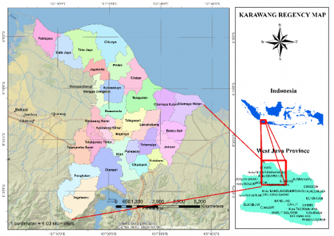
The study was conducted in Karawang Regency, West Java Province. It covers an area of 1,753.27 km2 (Figure 1).
It's known as a regional industrial activities area and an economic centre. It is surrounded by cities such as Jakarta, Bogor, Depok, Tangerang Bekasi, and Bandung. The Regency is populated by 2,44 million and consists of thirty sub-districts comprised of 297 villages and 12 special villages. Regionally, Karawang used to be divided into two major landscapes, namely lowland and coastal areas in the northern part with elevations ranging from 0 to 50 m and a hilly area in the southern part with elevations from 50 to 1,291 m above mean sea level [34].
Figure 1. The study area map
3.3 Study tools, materials, and data
The tools used in this study are; a laptop equipped with Microsoft Office packed 2019 and Powersim Studio10.
Table 1. The main data types and descriptions
|
Variable |
Initial value |
Unit |
Source |
|
Population of Karawang 2019 |
2354000 |
Person |
BPS |
|
Household Land demand for settlement 2009-2019 |
0.01 |
ha |
|
|
Average annual paddy cultivated area |
191526.58 |
Ha |
BPS |
|
Average paddy filed conversion rate 2009 -2019 based on paddy fields area |
2.78 |
%/year |
[24] |
|
Paddy fields area (ha) designated by RTRW in 2019 |
89296.34 |
ha |
[24] |
|
Average cropping index (CP) in Karawang |
2.7 |
- |
BPS |
|
Average Productivity |
7 |
ton/ha |
BPS |
While the materials/data used are paddy fields conversion figures published by Suliman and Setiawan [15], population and rice production data published by Karawang and west Java Province statistical bureau (BPS) between 2009 -2019 were used (see Table 1).
3.4 Model development steps/ procedures
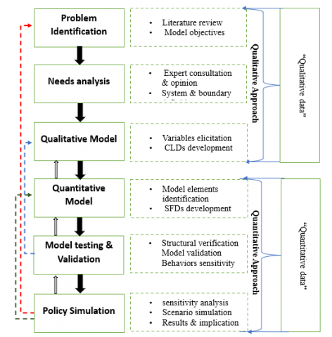
Vlachos et al. [35] stated that to demonstrate how a system dynamics model is constructed, it is necessary to identify the stakeholders, their needs, and problem formulation, delineate the system, model, verify and validate the outputs of the designed system and policy simulation (see Figure 3).
a. Problem Formulation
Population growth and development entail increased land need for settlements and other non-agricultural economic activities. In turn, the increased needs for land contribute to increasing the rate of agricultural land, including paddy fields. While the increased population growth will increase the total food demand as well as food per capita. Such conditions jeopardize the efforts of the government and communities to secure food. The government adopted Law No 41, 2009, to delineate Paddy fields and protect the agricultural land. The report BPS-Statistics of Karawang Regency [11] stated that such efforts are ineffective in reducing the conversion rate of paddy fields and their impact on future food security.
b. Identification of Stakeholders and Needs Analysis
Based on the problem that the system will address, stakeholders' opinions and needs should be considered via focus group discussions/interviews to justify their views on the existing problems, observations of the data collected, and proposed solutions [24]. The information regarding this step was obtained from the literature and official reports.
c. System Identification
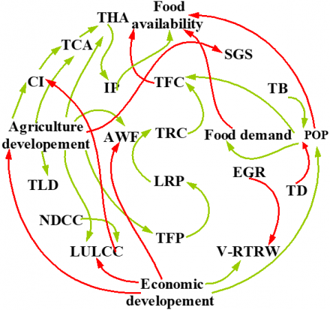
System identification aims to describe the system being studied in diagrammatic form (CLD and SFD).
POP: Population, TB: Total Birth, TD: Total Death, TFC: Total Food Consumption, TRC: Total Rice Consumption: LRP: Local Rice Production, TRP: Total Rice Production, TLD: Total Land Demand, NDCC: Natural Disaster & Climate Change, LULCC: Land Use Land Cover Change, V-RTRW: Violation of RTRW, AWF: Agriculture Work Force, TCA: Total Cultivated Area, THA: Total harvested Area, IP: Increased Productivity, EGR: Effective government Regulations, SGS: Sufficient Government Subsides,
Figure 2. CLD of model. The green arrows represent positive causalities (i.e., a change in variable X causes a change in variable Y in the same direction), while the red arrows indicate negative
Major subsystems and their relationships within and between the subsystems of the system as a whole are clearly described in Figure 2 as the Causal Loop Diagram (CLD).
d. Model Testing and Validation
Model testing is a critical part of the modelling process that helps build confidence in the model and its insights. The model output validation was conducted based on the available data, i.e., population, by using equations in Table 2.
a. Policy simulation /Model sensitivity and scenario analysis
The study chooses two variables, the birth rate of Karawang and the paddy fields conversion rate, to examine the model sensitivity against the analysed indexes; rice available per person (APP), rice surpuls (SPs) and Self-sufficiency level (SSL), as illustrated in Table 3. Additionally, the study proposed four policy scenarios to analyse (Table 4), comprising of; (1) business as usual (BAU#); (2) assuming TCA are designated by RTRW and using the conversion rate within RTRW (SNO#2); (3) increase in rice demand due to increasing in per capita per month average expenditure on rice and using a predicted conversion rate (SNO#3); and (4) assuming TCA are designated by LP2B and predicted conversion rates.
Table 2. summary of statistical measures to test the model behaviour
|
No |
Statistical measure |
Definition |
|
|
1 |
Maximum relative errors (M) (%) |
$M=\frac{\sum\left(X_{\mathrm{m}}-X_{\mathrm{d}}\right)}{\sum X_{\mathrm{d}}}$ |
The maximum possible divergence between model (X m) and data (X d) |
|
2 |
Coefficient of determination (R2) (dimensionless) |
$\begin{gathered}\mathrm{R}^2=\left(\frac{\operatorname{COv}\left(\mathrm{X}_{\mathrm{m}}-\mathrm{X}_{\mathrm{d}}\right)}{\sigma \mathrm{X}_{\mathrm{m}}-\sigma \mathrm{X}_{\mathrm{d}}}\right)^2\end{gathered}$ |
Score 0 to 1 (closer to 1 indicating well-fitted), COv = covariance; σ = standard deviation |
|
3 |
Mean absolute per cent error (MAPE) (dimensionless) |
$\begin{gathered}\text { MAPE }=\frac{1}{n} \sum\left|\frac{X_m-X_d}{X_d}\right|\end{gathered}$ |
Provide dimensionless metrics for the error and indicate the prediction accuracy |
Table 3. Index analysed in the stock flow diagram
|
No |
Index |
Definition |
Reference |
|
1 |
Self-sufficiency Level (SSL) |
The ratio between local resource production and resource consumption or demand |
Own Analysis |
|
2 |
Surplus (SPs) |
food surplus occurs when the supply of food exceeds the demand for it |
Own Analysis |
|
3 |
Availability per person (APP) |
The ratio between the resources supply (including imported resources) and the total population |
Own Analysis |
Figure 3. Model development steps modified from [2]
Table 4. Model sensitivity and policy scenario analysis
|
No |
Scenario |
Baseline (2019) |
Change |
|||
|
|
Testing Sensitivity |
|
↑30% |
↑50% |
↓30% |
↓50% |
|
1 |
KRW_Birth rate |
TSNY#1 |
TSNY#1a |
TSNY#1b |
TSNY#1c |
TSNY#1d |
|
|
0.0211 |
0.0274 |
0.0317 |
0.0148 |
0.01055 |
|
|
2 |
Conversion rate (%/year) |
TSNY#3 |
TSNY#3a |
TSNY#3b |
TSNY#3c |
TSNY#3d |
|
|
0.0278 |
0.0361 |
0.0417 |
0.0195 |
0.0139 |
|
|
|
Policy Scenarios |
|
|
|
|
|
|
1 |
The first Scenario (BAU#1) |
- |
- |
- |
- |
- |
|
|
Available paddy fields |
106,492.7 |
- |
- |
- |
- |
|
|
Conversion rate (%/year) |
0.0278 |
|
|
|
|
|
2 |
The second Scenario (SNO#2) |
SNO#2.0 |
SNO#2.1 |
SNO#2.2 |
SNO#2.3 |
SNO#2.4 |
|
|
Paddy Area of RTRW (ha) |
89,296.34 |
- |
- |
- |
- |
|
|
Conversion rate within RTRW (%/year) |
0.0232 |
0.0302 |
0.0348 |
0.0162 |
0.0116 |
|
3 |
The third Scenario SNO#3 |
SNO#3.0 |
SNO#3.1 |
SNO#3.2 |
SNO#3.3 |
SNO#3.4 |
|
|
Monthly average expenditure on rice (Rp) |
56.337 |
↑30% 73.238 |
↑50% 84.505 |
↑80% 101.406 |
↑100% 112.674 |
|
|
Paddy Area of RTRW (ha) |
89,296.34 |
- |
- |
- |
- |
|
|
Predicted conversion rate(%/year) |
0.0129 |
- |
- |
- |
- |
|
4 |
In the fourth Scenario SNO#4 |
SNO#4.0 |
SNO#4.1 |
SNO#4.2 |
SNO#4.3 |
SNO#4.4 |
|
|
Paddy Area of LP2B (ha) |
96,771.47 |
|
|
|
|
|
|
Conversion rate within LP2B (%/year) |
0.0129 |
0.0168 |
0.0194 |
0.0090 |
0.00645 |
4.1 Model structure
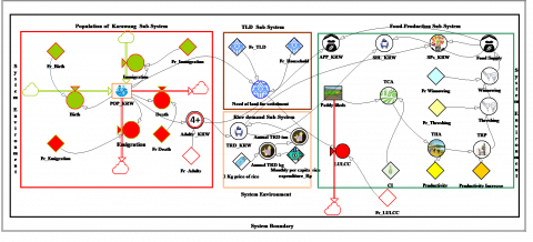
The model's Stock Flow Diagram (SFD) has been developed using PowerSim studio 10. The SFD consisted of four subsystems. Two are endogenous; Rice Production (dark green) and Rice demand (orange) (Figure 4). This quantified SFD is based on the qualitative CLD. The exogenous factors drive the change of this model, and it comprises population (red) and Total land demand (TLD) (dark brown) sub-models. Structurally, models include; 2 stocks, two inflows with rate, three outflows with rate, 15 constant tools, and 14 auxiliaries. Not all qualitative variables of CLD are covered in quantitative SFD due to data limitations of data availability/accessibility.
4.2 Model behaviours
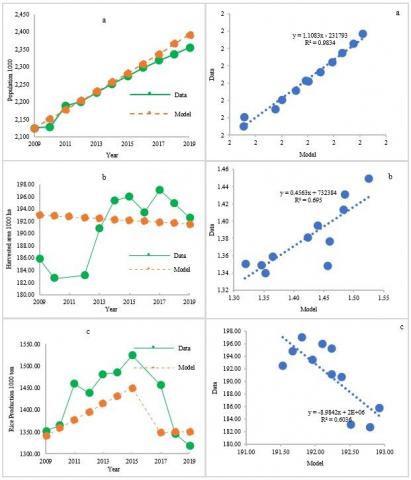
The study tested model behaviours by comparing the simulated data with actual data (2009-2019) to assess how well the model outputs replicate observed system behaviour. Based on the available data, Population data, Paddy cultivated area and rice production were chosen to be tested. The test shows satisfactory agreement between the model simulation and the actual data in terms of percentage, absolute numbers, and trends in all test variables (Table 5 and Figure 5) except harvested area data (Figure 5b), which shows lower agreement due to a various data sources used. The overall results indicated that the model demonstrated adequacy in capturing the actual system behaviours that support further scenario analysis.
POP_KRW; Population of Karawang, Fr; fraction, Adults; people aged 4+ years old, TDL; Total Land Demand, TRD; Total Rice Demand, LULCC; Land use Land Cover Change, CI; Cropping Index, TCA; Total Cultivated Area, THA; Total Harvested Area, TRP; Total Rice Production, SPs; Surplus, SSL; Self-sufficiency Level, APP; Availability Per Person.
Figure 4. SFD model. Square boxes indicate stocks, thick arrows with ‘clouds’ indicate flows, and circles indicate connectors (auxiliary variables). Thin connecting arrows transmit information between model elements
Table 5. Testing Model behaviours of selected variable (2009-2019)
|
No |
Selected variable |
Measures |
||
|
M (%) |
R2 (dmnl) |
MAPE (dmnl) |
||
|
1 |
Population (people) |
0.51% |
0.983 |
0.49 |
|
3 |
Paddy cultivated area (ha) |
0.57% |
0.604 |
3.44 |
|
4 |
Rice production (ton) |
2.90% |
0.695 |
0.54 |
|
|
Overall |
1.33% |
0.760 |
1.49 |
Figure 5. Model validation: a) Karawang population; b) harvested area; and c) Rice production
4.3 Model limitations
The tailored model is based on the ten years' assessment of paddy fields conversion data and prediction to 2031 in line with current Regional Spatial Planning (RTRW). The model sets to run from 2019 (baseline) to the end of the century (2100) with a setting report every three years. Since it is based on the ten years of assessment data, the projection figures might only be reliable up to 2031. The projection data might also be reliable over the next RTRW period (2031-2051) if there is no significant change in the Regency paddy fields area, conversion rate, population growth, and rice consumption.
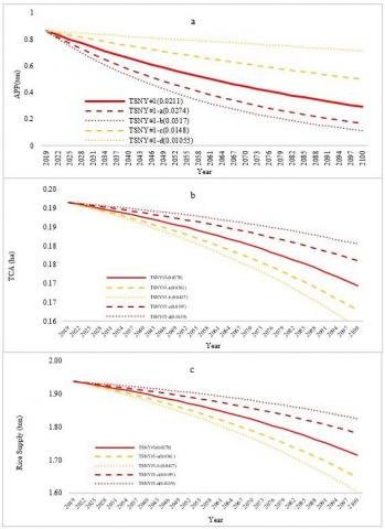
4.4 Sensitivity analysis
Figure 6 shows the sensitivity analysis results. Such analysis aimed to build confidence in the system dynamic model by testing the model output on how it reflects reality. However, changes in population sub-system components e.g., an increase in birth should be reflected in form of an increase in the total rice demand. Also changes in the rice production sub-system components e.g., an increase or decrease in the local rice supply should be a direct response to a reduction in the paddy cultivated area due to paddy fields conversion, cropping index, or productivity. Such analysis chooses birth rate (TSNY#1) and conversion rate (TSNY#3) variables to examine the sensitivity of the system. As shown in Table 4 it assumes that the values of the variables will increase by 30% and 50% and decrease by the same percentages.
Hence, based on the simulations (TSNY#1a to TSNY#1d), changes in birth rate have significantly altered Availability Per Person (APP). Meaning that increase in birth by 50% has resulted in an increase of the rice demand by the same percentage and consequently reduced the rice APP and vice versa. While changes in conversion rate (TSNY#3a to TSNY#3a) will impact the cultivated/harvested area and rice production, thus rice supply. The results indicated that the model captured the reality of system components interacting in the real world. Hence, supporting policy scenarios.
Figure 6. Sensitivity analysis: a) availability per person; b) total cultivated/ harvested area; c) rice supply
4.5 Analysis of policies scenarios
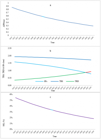
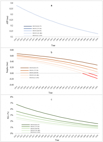
4.5.1 Business as usual (BAU#1)
The model sits to run from 2019 to 2100 with a report setting of every three years. Under the business-as-usual scenario (Figure 7), the model shows the inversion proportionality of rice demand and supply. It shows that the population of the Karawang regency increased from 2,354,000 million in 2019 to 6,150,266 million by end of the century, representing an increase of 161.269% from the baseline (2019). This increase in the population represents an average of 1.4 per cent/year growth of population during the first thirty years (2019-2049) mainly due to the increase of birth and immigration into the regency as its industrial area attracts a workforce.
Figure 7. BAU#1 scenario: a) APP; b) surplus (SPs), Total Rice Supply (TRS), and Total Rice Demand (TRD); c) SSL
Due to this increase, the Total Rice Remand (TRD) of the Karawang population will increase from 356.8 thousand (K) in 2019 to roughly 0.9 million tons by the end of the century. On the other hand, the paddy fields area of Regency will be reduced from 191.5K ha in 2019 to 169.4K ha in 2100. This represents a reduction of 22.1K ha or 161%; as a result, the rice production/ Total Rice Supply (TRS) will drop from 1.9 million tons in 2019 to 1.7 million tons at the end of the century, as shown in Figure 7 b. The main driver of reducing production/supply is the paddy fields conversion. Consequently, the Availability Per Person (APP), rice surplus (SPs), and Self-sufficiency level (SSL) will be reduced by 66.20, 50.55, and 359%, respectively, between 2019-2100, as shown in Figure 7.
4.5.2 RTRW scenario (SNO#2)
Based on the previous study conducted by [15] show that the paddy field conversion rate is lower within the paddy fields area designated by the 2013 Karawang regional spatial planning (RTRW) and much higher outside that area. Hence, in this scenario, the study assumes the total paddy fields are those within RTRW and uses different conversion rates within the same area. This scenario highlighted that if the PFs conversion rate within the RTRW area increases by 30% (SNO#2.1) then paddy fields will be reduced from 89.2K ha in 2019 to just 60K ha by the end of the century, approximately 29K ha of paddy fields will be converted. While increasing the conversion rate within the same area by 50% (SNO#2.2) will reduce paddy fields of the area from 89.2K ha in 2019 to just 54K ha by the end of the century, a reduction of 32.9K ha. On the other hand, reducing the conversion rate by 30% (SNO#2.3) will reduce PFs from 89.2K ha to 71 thousand ha in the end, only 18K ha of PFs will be converted. Whereas a reduction of conversion rate by 50% (SNO#2.4) will reduce the PFs from 89.2K ha to 74.8K ha or a conversion of 14.4K ha by end of the century.
The SNO# scenario shows that SNO#2.1 will reduce KRW APP, SPs, and SSL by 7.96, 28.84, and 12.10%, respectively, from baseline. SNO#2.2 scenario showed APP (Figure 8 a), SPs (Figure 8 b), and (Figure 8 c) SSL would reduce by 14.16, 47.20, and 20.10%, respectively, from baseline. In comparison, SNO#2.3 will increase APP, SPs, and SSL of Regency by 8.85, 28.48, and 12.10%, respectively, from baseline. While the SNO#2.4 scenario will increase APP, SPs, and SSL of KRW by 14.16, 47.20, and 20.10%, respectively, from baseline.
Figure 8. SNO#2: a) APP; b) Surplus (SPs); c) SSL
4.5.3 Increased rice demand scenario (SNO#3)
In this scenario, the model aimed to assess the impact of change in rice consumption/demand relative to APP, SPs, and SSL, assuming that the rice demand will increase by 30% to 100%. The 100% increase would represent an upper limit of increase. There are two logical reasons behind this assumption; I) the BPS report shows an increase in per capita per year income, and II) the reports also show that per capita expenditure has increased by 50.82 % between 2009-2019.
Thus, when income increases, disposable income rises, and people consume more goods & services.
The simulation revealed that increasing per capita monthly rice average expenditure (PRE) by 30% (SNO#3.1) would increase the Total Rice Demand (TRD) from 231.9K tons in 2019 to 605.8K tons, in the end, an increment of 373.9K ton. Increasing PRE by 50% (SNO#3.2) will increase the TRD from 267.5K to 699.1K tons or an increase of 431.5K tons. Increasing PRE by 80% (SNO#3.3) would increase TRD from 321K to 838.9K tons, an increment equivalent to 517.8K tons. Whereas an increase in PRE by 100% (SNO#3.4) will increase the regency TRD from 356.7K to 932.1K tons. Therefore, SNO#3.1 would increase KRW SPs (Figure 9 b) and SSL (Figure 9 c) by 49.80 and 36.90%, respectively, from baseline. Whereas SNO#3.2 will increase SPs, and SSL by 88.99, and 53.40%, respectively, from baseline. Conversely, SNO#3.3 will increase SPs and SSL by 132.79 and 71.20%, respectively, from baseline. SNO#3.4 will increase SPs and SSL by 165.99 and 80.10%, respectively, from baseline. Because the change in population growth and reduction of paddy fields remained the same, the scenario did not show any change/significant trends in APP measure shown in Figure 9 a. the model also showed that the Regency will be out of rice surplus when in 2094 and 2085 when the consumption/ demand of rice increases by 80 and 100% respectively.
Figure 9. a) APP; b) Surplus (SPs); c) SSL
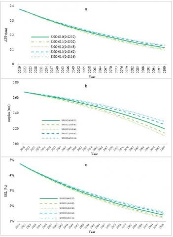
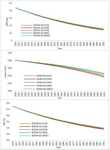
4.5.4 LP2B scenario (SNO#4)
This scenario used the area of LP2B paddy fields and future conversion rate within the production sub-models. It aims to project the possible scenario of APP, SSL, and SPs based on the LP2B paddy area. It assumes that the future paddy fields conversion rate within such area will increase by 30% (0.0168) SNO#4.1, and 50% (0.0194) SNO#4.2, and also decrease by 30% (0.0090) SNO#4.3, and 50% (0.00645) SNO#4.4. An increase in conversion rate means reducing the available paddy field, less cultivated area, and thus less rice production, and vice versa.
Therefore, the simulation revealed that SNO#4.1 will reduce KRW PFs by 13.3K ha by end of the simulation or an increase of 3.1K ha from the baseline. Thus, such a scenario would increase KRW rice SSL, APP, and SPs by 1.24, 1.14, and 3.92%, respectively (Figure 10), from the baseline. SNO#4.2 will reduce the PFs of KRW by 15.4K or will increase the PFs converted area by 5.1K ha from the baseline. Hence, it will increase rice SSL, APP, and SPs by 2.06, 2.06, and 6.54%. In contrast, SSL will decline by 1.22 and 2.02% (Figure 10 c) due to the reduction of PFs by 3.1K and 5.1K ha induced by scenario SNO#4.3 and SNO#4.4 respectively. And they will reduce APP (Figure 10 a) by 1.37 and 2.06%, (Figure 10 b), and also will reduce the Regency rice surplus by 3.92 and 6.49 respectively. Scenarios SNO#4.2 and SNO#4.2 have significant impacts, especially on the rice surplus. It means an increase in conversion rate by 50% within the LP2B area will reduce the rice surplus by 443,880.44 tons and 52,329.00 from the baseline by the end of the century. Conversely, a reduction in the conversion rate by 50% will increase the KRW rice surplus by 339,624.96 tons and 51,926.48 tons from the baseline. The change in the surplus due to Scenarios SNO#4.2 and SNO#4.2 is almost equal to 30% of Karawang rice demand. In other words, the change in surplus is enough to meet the demand of 657 thousand people, which is equivalent to the demand of six sub-districts (kacamatan) complained, namely, Tegalwaru, Ciampel, Telukjambe Timur, Klari, Cikampek, and Kotabaru.
Figure 10. SNO#4: a) APP; b) Surplus (SPs); c) SSL
4.6 Policy implication and possible interventions
Table 6 summarizes the policies and their main implications and possible practical action to be taken regarding paddy field conversion and how food production can be sustained. It highlighted two main concerns; I) the implications of various simulated policies on the different sub-models. II) possible practical actions. Where all the indicated implications are based on the simulation of the model, whereas the proposed measures in "possible practical actions" are based on the simulated scenarios and other sources such as previous studies, experts, and modellers' opinions. Hence, there are various implications of simulated scenarios/policies towards APP, SPs, and SSL. Generally, an increase in land conversion and population growth rate led to a decrease (↓) of measured parameters. In contrast, increased demand decreased SPs and SSL with no significant effect on APP (Table 6). To deal with the undesirable implication of the land sub-model, means of optimizing/controlling paddy field conversion should be considered. This means reducing the conversion rate to a level that does not significantly impact the APP, SLL, and SPs. The conversion rate must be kept at least 50% less than the current conversion rate (1% per year) and less than 0.5% per year within the RTRW area to achieve the target of sustainable protected agricultural land (LP2B). Paddy field conversion due to the horizontal expansion of settlements within the farmland can be optimized by adopting the vertical settlement plan. However, densification of the rural non-farm settlements will play an important role in controlling the horizontal expansion of non-farm occupations (i.e., construction of industry, housing, brickfield etc.), which is impacting the conversion of agricultural land, particularly paddy fields, and this is in line with what Alam et al. [36] argued about the 2011 Bangladesh Agricultural Land Protection & Land Use Bill. Paddy field conversions within the designated areas indicate that there is a violation of regulations (RTRW) via land use permit. Therefore, further measures such as linking the land use permit with the regional spatial planning (RTRW) should be taken into account to enforce the law, stop the RTRW violation, and thus, control paddy fields conversion within such area.
According to Chofyan et al. [37], a good functioning irrigation network is a supportive factor in obtaining optimal production and productivity. Its absence may become a conversion driver. The study stated that in 2015 almost 82% of Regency irrigation networks were identified as damaged; out of that, 55% of them were severely damaged, 27% were moderately damaged, and only 18% were slightly damaged.
Paddy fields located near damaged irrigation canals are characterized by low production. Thus, they have the potential to be converted because farmers/ landowners seeking high income from their land and low-productive paddy fields take more input but bring low income compared to other non-farm investments. Hence, maintaining and keeping the irrigation canals in good condition will ensure adequate irrigation water delivery to meet the production/productivity targets and reduce the odds of conversions.
Although there is no deficiency of rice supply in Karawang Regency due to the paddy fields conversion, measures such as family planning and food diversification will help reduce pressure on the rice surplus from Karawang. Since the Regency is known as the second-largest rice producer in the province and is called "lumbung padi nasional" its rice supply is not only for Karawang but for the whole of West Java Province. Hence, a family planning policy will not only control the growth of the population, which impacts the conversion process but also help reduce the pressure on the demand for rice alongside food diversification plans.
Table 6. Police implication and possible interventions
|
No |
Policy and planning |
Implication |
Possible practical interventions |
|
1 |
Land & Environment Land conversion (↑) |
APP (↓) ∗ SPs (↓) ∗ SSL (↓) ∗ |
|
|
2 |
Population birth rate (↑) |
APP (↓) ∗ SPs (↓) ∗ SSL (↓) ∗ |
|
|
3 |
Food Per capita consumption (↑) |
APP (→) ∗ SPs (↓) ∗ SSL (↓) ∗ |
|
Notes: ↑ (increasing trend), ↓ (decreasing trend), → (less or no influence), LP2B (sustainable food crop agriculture land policy), RTRW (Regional Spatial Planning), ∗ (model-based), ∗∗ (other evidence-based).
The study has aimed to develop a dynamic model and analyse possible future scenarios to support the formulation of recommendations/policies to uphold the rice self-sufficiency of the Regency. This has been done by visualizing the threats and challenges. Based on the model simulations, the study can successfully build a model reflecting the real system. The results illustrated the current and future status of rice self-sufficiency in the Karawang Regency. It has been emphasised that paddy field conversion is the main threat that may undermine the future rice supply for Regency. On the other hand, population growth and /or change in consumption patterns will also alter the rice demand, thus impacting APP, SPs, and SSL on the Regency level.
Based on the above conclusions, the study recommended that proposed possible interventions should be considered along with formulating and implementing upcoming Regional Short, Medium, and long-term Development Plans. Development practitioners, policy, and decision-makers can use this model, including the generated information in evaluating and planning future food security policies with particular attention to the threat imposed by scenarios SNO#3.3 and SNO#3.4. Further research should consider enough historical data e.g., +20 years for more accurate simulation to overcome the limitation of this model. They also should take into account the increased cultivated area which increases due to the conversion from forests and bare land into paddy fields. Thus more reasonable projections and policy scenarios.
The authors would like to acknowledge the financial assistance provided by the government of Indonesia through the Ministry of Education and Culture and IPB University. They also would like to thank the University Consortium of SEARCA for their financial support. This work would not be accomplished without such aid.
[1] Bandumula, N. (2018). Rice production in Asia: Key to global food security. Proceedings of the National Academy of Sciences, India Section B: Biological Sciences, 88: 1323-1328. https://doi.org/10.1007/s40011-017-0867-7
[2] Purwanto, A., Sušnik, J., Suryadi, F.X., de Fraiture, C. (2021). Quantitative simulation of the water-energy-food (WEF) security nexus in a local planning context in indonesia. Sustainable Production and Consumption, 25: 198-216. https://doi.org/10.1016/j.spc.2020.08.009
[3] Ambarwulan, W., Munibah, K. (2013). Landuse change during a decade as determined by landsat imagery of a rice production region and its implication to regional contribution to rice self sufficiency: Case study of Karawang Regency, West Java, Indonesia, 834-840. http://repository.ipb.ac.id/handle/123456789/67827
[4] BPS-Statistics Indonesia. (2022). Statistical Year Book of Indonesia. (Jakarta). https://www.bps.go.id/publication/2022/02/25/0a2afea4fab72a5d052cb315/statistik-indonesia-2022.html, accessed on Oct. 5, 2022.
[5] BPS-Statistics of West Java Province. (2020). JAWA BARAT PROVINCE IN FIGURES 2020 (Bandung). https://jabar.bps.go.id/publication/2020/04/27/cfab9a400cf304f800182a5f/provinsi-jawa-barat-dalam-angka-2020.html, accessed on Oct. 5, 2022.
[6] Hanipah, H.S.H., Tambunan, R.P. (2020). Increasing local farmers sustainability index status to preserve agricultural sustainability. http://dx.doi.org/10.4108/eai.22-10-2019.2291464
[7] Franjaya, E.E., Setiawan, Y., Syartinilia. (2017). Monitoring of landscape change in paddy fields: Case study of karawang district-west java province. In IOP Conference Ser: Earth and Environmental Science, 54(1): 012016. https://doi.org/10.1088/1755-1315/54/1/012016
[8] BPS-Statistics of Karawang Regency. (2015). Karawang in Figures. (Karawang). https://karawangkab.bps.go.id/publication/2015/11/02/548afb7c6951d06428132d81/kabupaten-karawang-dalam-angka-tahun-2015.html, accessed on Oct. 5, 2022.
[9] BPS-Statistics of Karawang Regency. (2019). Karawang Regency in Figures. (Karawang).
[10] https://karawangkab.bps.go.id/publication/2019/08/16/33e658b7bfc07dc98a28f9bf/kabupaten-karawang-dalam-angka-2019.html, accessed on Oct. 5, 2022.
[11] BPS-Statistics of Karawang Regency. (2009). Karawang in Figures. (Karawang).
[12] https://karawangkab.bps.go.id/publication/2010/11/22/e1d8bdc145a911ed39069bab/kabupaten-karawang-dalam-angka-tahun-2009.html, accessed on Oct. 5, 2022.
[13] Purbiyanti, E., Yazid, M., Januarti, I. (2017). Paddy fields conversion in Indonesia and its effect on The Policy of the government Purchase Price (HPP) of grains/rice. Jurnal Manajemen dan Agribisnis. https://doi.org/10.17358/jma.14.3.209
[14] Riadi, B. (2018). Strategy to maintain food security in the area of flood hazard in karawang regency. In IOP Conference Series: Earth and Environmental Science, 165(1): 012029. https://doi.org/10.1088/1755-1315/165/1/012029
[15] Riadi, B., Barus, B., Yanuar, M., Pramudya, B. (2018). Identification of flood area in the coastal region using remote sensing in Karawang Regency, West Java. In IOP Conference Series: Earth and Environmental Science, 165(1): 012029. https://doi.org/10.1088/1755-1315/162/1/012042
[16] Riadi, B., Geospasial, B. I., Barus, B., Widiatmaka, W. (2018). Spatial modeling of land use/land cover changes for flood hazard analysis on paddy fields and their impact on rice production. Journal of Engineering and Applied Sciences, 13: 4496-4502.
[17] Suliman, S., Setiawan, Y., Syartinilia, (2022). Assessing the paddy fields conversion using optical satellite imageries: A case study in Karawang Regency, West Java. In IOP Conference Series: Earth and Environmental Science, 950(1): 012092. https://doi.org/10.1088/1755-1315/950/1/012092
[18] Franjaya, E.E., Syartinilia, Setiawan, Y. (2018). Modelling landscape change in paddy fields using logistic regression and GIS. In IOP Conference Series: Earth and Environmental Science, 149(1): 012002. https://doi.org/10.1088/1755-1315/149/1/012002
[19] Aruminingsih, A., Martono, D.N., Soesilo, T.E.B., Tambunan, R.P. (2022). Flood disaster risk model in karawang regency's industrial area, west java province, indonesia. Indonesian Journal of Geography, 54(1): 70-82. https://doi.org/10.22146/ijg.69027
[20] Cakranegara, P.A. (2021). Industrialization and loss of rice barns (Karawang Case Study). In IOP Conference Series: Earth and Environmental Science, 828(1): 012050. https://doi.org/10.1088/1755-1315/828/1/012050
[21] Liu, J., Guo, Q. (2015). A spatial panel statistical analysis on cultivated land conversion and Chinese economic growth. Ecological Indicators, 51: 20-24. https://doi.org/10.1016/j.ecolind.2014.09.046
[22] Irene, P.L. (2015). Farmland conversion in Karawang, Indonesia: discourse analysis. Faculty of Bioscience Engineering, Universiteit Gent. https://libstore.ugent.be/fulltxt/RUG01/002/217/256/RUG01-002217256_2015_0001_AC.pdf
[23] Zhou, Y., Li, X., Liu, Y. (2020). Land use change and driving factors in rural China during the period 1995-2015. Land Use Policy, 99: 105048. https://doi.org/10.1016/j.landusepol.2020.105048
[24] Veldkamp, A., Fresco, L.O. (1996). CLUE: a conceptual model to study the conversion of land use and its effects. Ecological Modelling, 85(2-3): 253-270. https://doi.org/10.1016/0304-3800(94)00151-0
[25] Borras Jr, S.M., Kay, C., Gómez, S., Wilkinson, J. (2012). Land grabbing and global capitalist accumulation: key features in Latin America. Canadian Journal of Development Studies/Revue Canadienne d'études du déVeloppement, 33(4): 402-416. https://doi.org/10.1080/02255189.2012.745394
[26] Bala, B.K., Arshad, F.M., Noh, K.M. (2017). System dynamics. Modelling and Simulation. https://doi.org/10.1007/978-981-10-2045-2
[27] Sofyang, D.R. Kaimuddin. (2013). Dynamic System of Capability Agricultural Land Consolidation in the Context of South Sulawesi Rice Self-Sufficiency. https://docplayer.info/45399561-Sistem-dinamis-daya-dukung-lahan-pertanian-dalam-rangka-pemantapan-swasembada-beras-sulawesi-selatan.html, accessed on Oct. 5, 2022.
[28] Fristovana, T., Hubeis, M., Cahyadi, E.R. (2019). Dynamic system model of rice self sufficiency towards food security. Jurnal Manajemen & Agribisnis, 16(3): 121-121. https://doi.org/10.17358/jma.16.3.121
[29] Martínez-Jaramillo, J.E., Arango-Aramburo, S., Giraldo-Ramírez, D.P. (2019). The effects of biofuels on food security: A system dynamics approach for the Colombian case. Sustainable Energy Technologies and Assessments, 34: 97-109. https://doi.org/10.1016/j.seta.2019.05.009
[30] Wang, F., Liu, S., Liu, H., et al. (2022). Scenarios and sustainability of the economy–nitrogen-resource–environment system using a system dynamic model on the Qinghai-Tibet Plateau. Journal of Environmental Management, 318: 115623. https://doi.org/10.1016/j.jenvman.2022.115623
[31] Amiri, A., Mehrjerdi, Y.Z., Jalalimanesh, A., Sadegheih, A. (2020). Food system sustainability investigation using system dynamics approach. Journal of Cleaner Production, 277: 124040. https://doi.org/10.1016/j.jclepro.2020.124040
[32] Walters, J.P., Archer, D.W., Sassenrath, G.F., et al. (2016). Exploring agricultural production systems and their fundamental components with system dynamics modelling. Ecological Modelling, 333: 51-65. https://doi.org/10.1016/j.ecolmodel.2016.04.015
[33] Purwanto, A., Sušnik, J., Suryadi, F.X., de Fraiture, C. (2019). Using group model building to develop a causal loop mapping of the water-energy-food security nexus in Karawang Regency, Indonesia. Journal of Cleaner Production, 240: 118170. https://doi.org/10.1016/j.jclepro.2019.118170
[34] Yulianto, F., Sofan, P., Zubaidah, A., Sukowati, K.A.D., Pasaribu, J.M., Khomarudin, M.R. (2015). Detecting areas affected by flood using multi-temporal ALOS PALSAR remotely sensed data in Karawang, West Java, Indonesia. Natural Hazards, 77: 959-985. https://doi.org/10.1007/s11069-015-1633-x
[35] Vlachos, D., Georgiadis, P., Iakovou, E. (2007). A system dynamics model for dynamic capacity planning of remanufacturing in closed-loop supply chains. Computers & Operations Research, 34(2): 367-394. https://doi.org/10.1016/j.cor.2005.03.005
[36] Alam, A.F.M., Asad, R., Kabir, E. (2016). Rural settlements dynamics and the prospects of densification strategy in rural Bangladesh. SpringerPlus, 5(1): 1-11. https://doi.org/10.1186/s40064-016-1883-4
[37] Chofyan, I., Rustan, H.U., Hariyanto, A. (2015). Upaya mempertahankan Kabupaten Karawang sebagai lumbung padi nasional. http://repository.unisba.ac.id/bitstream/handle/123456789/12083/fulltext_chofyan_penelitian_lppm_unisba_2015.PDF?sequence=1&isAllowed=y, accessed on Oct. 5, 2022.