Arkan Ali Al-Nasrawy*![]() | Ahmed Hani Al-Tamimi
| Ahmed Hani Al-Tamimi![]() | Hayam Al-Saatee
| Hayam Al-Saatee![]()
© 2023 IIETA. This article is published by IIETA and is licensed under the CC BY 4.0 license (http://creativecommons.org/licenses/by/4.0/).
OPEN ACCESS
Al-Noor City, which is one of the cities affiliated to Al-Najaf Governorate in southern Iraq, this city suffers from the reluctance of the residents who were granted plots of land by the local government in Najaf to build and live there despite the ownership of more than 16,000 residential plots of land to the population, the study area enjoys many developmental elements for various economic activities in the field of agriculture, industry, trade and tourism. However, job opportunities are scarce and investment projects do not exist, either within the city or in its region. The research team adopted scientific methods in analysis and building the necessary strategies and using similar examples, and through several planning and engineering programs such as GIS, AutoCAD and others, a set of maps included in the research paper were extracted. It was completed gathering the necessary information to diagnose the development potential of the city and its surroundings through the technical methods used in this field such as personal interviews, questionnaire forms, the search for official documents and visits to the relevant institutions. that information was analyzed according to the SWOT matrix to come up with a strategic vision that would make this city (al-Noor City) capable of attracting residents and relieving the great pressure on the city of Najaf. The most important conclusion of the paper is the need to implement a strategy based on enhancing the tourism potential in the sea of Najaf and the lakes near the city. Enhancing investment in industrial construction projects, especially the brick, cement and food industries, as well as paying attention to the agricultural potential of the study area, in addition to enhancing water, sewage, the environment and main and secondary roads services.
developmental elements, planning strategies, public services, residential use, satellite cities, SWOT matrix
The cities affiliated with the main cities contribute a fundamental and important role in relieving the pressure on those cities resulting from excessive population growth. Many planning strategies have emerged to address the problems of megacities with high population attraction. It has taken multiple forms, including the establishment of satellite cities, noon cities, new cities, but some of these experiences have become counterproductive. Instead of being a solution, they have become an additional burden on the major cities affiliated with them in terms of functional, administrative, social and economic terms. The reason is due to the presence of shortcomings in the strategic vision of the process of establishing, growing and developing these cities, especially the policies and programs designed to attract the population, such as jobs, services, security and decent livelihoods. Residential use also constitutes the most important and largest percentage of land uses, so any strategy that aims to attract residents must pay attention to this vital part, directly or indirectly, through other fields, such as providing job opportunities and revitalizing the tourism, recreational, industrial and other fields according to the available capabilities and resources. Hence the importance of the issue, as (Al-Noor City) suffers from a clear reluctance of the population to live in it and build a stable life. Because those concerned with the subject and the decision-makers (The Najaf Governorate, the District Commissioner of Al-Nour District, the Directorate of the Municipality of Najaf, the Construction Council and the service institutions) were satisfied with the stage of land distribution, the extension of water and electricity networks, the implementation of some main roads and public services such as schools and health centers, and they neglected the stages of continuity of growth and development of this city, due to the lack of It is large at the level of the database, especially maps, urban plans and urban designs for the city, thus neglecting the development potential of this city.
The research adopted the descriptive approach of similar examples and surveying information from the study site through field visits and to service institutions such as the Council for Reconstruction, Municipality and Urban Planning, and analyzing that information according to the matrix of elements (strength and weakness) and (opportunities and threats), to diagnose the development potential of the city and derive strategic goals. The research team used a number of Programs, statistics, field surveys, and questionnaires for the population on the one hand, and the executive authorities of the project on the other hand.
The idea of satellite cities as an urban development policy emerged in the early 20th century based on the writings of Ebenezer Howard. It took shape following the creation of two garden cities around London, England. At the global level, the goals behind its construction varied, including the goal of spreading industrial development and mitigating gaps in levels of development between regions, as is the case in Britain. Other goals include relieving pressure on major cities, as in France and Egypt, and building new capitals for countries such as Australia and Brazil, or exploiting natural and human resources, as is the case in industrial cities in the Kingdom of Saudi Arabia, such as the city of “Jubail”. From there, most countries in the world began to think of establishing new cities as a support for the existing ones, with the aim of relieving pressure on major cities in terms of redistributing industrial centers and trying to solve housing problems within a comprehensive development framework to achieve a number of social and urban goals. A satellite city is that part of the region located directly adjacent to the mother city and is closely related to it. Most of the population in this part turn to the main city to obtain goods and services. Therefore, it may sometimes be called (the immediate area) or it may be called (the area adjacent to the city). Hence, the housing sector in this city needs many components in order to contribute to achieving the main goal of the emergence of these cities, which is to reduce population pressure on the mother cities, thus reducing pressure on the housing stock on the one hand, and services on the other hand [1].
Among the most important elements necessary to attract residents in cities are the following [2]:
3.1 Providing basic services and transportation methods
The availability of infrastructure and public services is one of the factors of population attraction, as we find that the places where most of the services are available have a large population concentration, as well as for transportation methods, which facilitate movement and movement and reduce congestion and bottlenecks.
3.2 Providing job opportunities
The provision of job opportunities is one of the most important factors of population attraction, through the exploitation of the resources available in the city for the establishment of industries, commercial projects or tourism, and so on. As most of the population is concentrated in areas that provide job opportunities for them, the same applies to the immigrant population from the countryside to the city in search of work.
3.3 Providing a strong economic base
It refers to all procedures, laws and legislations supporting investment and economic development that would enhance the economic importance of the city and thus attract investments and provide job opportunities.
The strategies for attracting the population in the satellite cities are as follows [3]:
Providing job opportunities for the population and a rewarding income that keeps them from thinking about looking for an alternative.
Providing suitable housing units for newly married young people, especially for those who have problems in adequate housing in their old home.
Providing means of security, safety, education, health and entertainment for the population in the satellite cities.
Providing basic public services, efficient infrastructure services, and a network of roads that achieve easy access and at reasonable costs.
Enhancing the concept of sustainability in all development strategies directed at satellite cities.
5.1 Tenth of Ramadan city (Egypt)
It enjoys its proximity to the city of Cairo, and is considered part of Greater Cairo. It was established by Republican Decree No. 249 in 1977 in an effort to attract foreign and local capital with the intent of providing job opportunities for the country's youth, as well as removing people from the Nile Valley to relieve pressure on existing infrastructure and reduce overcrowding. Al Ashir min Ramadan is located on the Cairo-Ismailia desert highway, 46 km (29 mi) from Cairo and 20 km (12 mi) from the city Belbeis. This city adopted the strategy of revitalizing the housing sector by revitalizing the industrial sector, the public services sector, and infrastructure, which contributed to increasing job opportunities and increasing the number of factories. This strategy has worked to increase the percentage of factories, which amounted to four and a half times between 1988 and 2007, and thus Increasing the number of workers to about seven times the number between the aforementioned two years. These percentages are consistent with the increase in the population, which has reached almost ten times. This shows the great impact of the industrial sector in providing job opportunities in this city and the neighboring cities as well [4], Table 1.
Table 1. The increase in the level of population, employment and the number of factories in the Egyptian experience of the back cities between 1988-2007
|
Development elements |
1988 |
2007 |
|
The number of factories |
259 |
1252 |
|
number of workers |
19690 |
143700 |
|
population |
20000 |
129121 |
Source: Research team based on strategies and mechanisms for the development of new cities, Saed Abbas Ali
5.2 Aqaba city (Jordan)
It is the only coastal city in Jordan and the largest and most populous city on the Gulf of Aqaba. Situated in southernmost Jordan, Aqaba is the administrative center of the Aqaba Governorate. The city had a population of 148,398 in 2015 and a land area of 375 square kilometers (144.8 sq. mi). Today, Aqaba plays a major role in the development of the Jordanian economy, through the vibrant trade and tourism sectors. The Port of Aqaba also serves other countries in the region [5].
The strategy of revitalizing the tourism sector was adopted in the development of this city to revitalize the housing sector and achieve population attraction, which provided important job opportunities and the adoption of local labor and the reduction of dependence on foreign labor for the period between (2001-2014). This strategy has contributed to doubling the number of hotels in the city, which is an important indicator for the development of the tourism sector in this city, which resulted in an increase in the population growth rate [6], Table 2.
Table 2. The increase in the level of population, employment and the number of tourists in the Jordanian experience
|
Development elements |
2001 |
2014 |
|
Number of hotels and tourist establishments |
34 |
78 |
|
The number of foreign workers |
25000 |
9500 |
|
population |
71000 |
188160 |
Source / research team, http://www.cpasegypt.com/Articles/Baki/Study/35.pdf,2-jul-2020
Through the previous examples, it is clear that attracting residents took place in successive periods of time by activating non-residential uses such as industry, agriculture, commerce, and tourism, as well as upgrading residential use in order to achieve standards of quality of life and adequate housing. Activating non-residential activities varies according to the capabilities and elements of available development. On the tenth of Ramadan, the focus was on industrial activities, while the city of Aqaba was focused on tourism to achieve population attraction and thus reduce pressure on its main cities.
Al-Noor City is one of the projects intended for low-income people, and this project began in 2009. The field side of this research paper included frequent visits by the research team due to the scarcity of information available on the study area, where many problems that the city's residents suffer from were explored. The major shortage in the infrastructure services of the city, such as the lack of paved roads, potable water, the lack of electric power, and the problem of waste. In addition to the environmental pollution resulting from the industrial areas close to the city. The study area also suffers in some days of the year to drowning due to torrential rains, with the absence of real solutions by the government local to this problem. This part of the research also aims to explore its resources, capabilities and development elements available in it [7]. Figure 1.
Among the most important sequential characteristics of the study area are the following [8]:
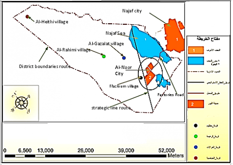
Its location represents a link between the city of Najaf and the villages surrounding the city of Al-Nour, represented by Al-Aziyah, Al-Asawid, Al-Rahima ... etc. as shown in Figure 2.
The presence of agricultural lands suitable for producing a variety of crops, especially vegetables and grains.
The presence of large lands suitable for distributing a large number of housing units [9].
The lands surrounding Al-Nour City are characterized by the availability of raw materials for food industries and the manufacture of cement and bricks.
Al-Noor City has the tourism potential due to the presence of the Najaf Sea and some lakes near it, which is one of the factors that attract foreign and local investments. It is bordered on the north by the Najaf Sea and on the south by a lake suitable for the establishment of tourism projects in addition to the vast areas of untapped land as shown in Figures 1, 2.
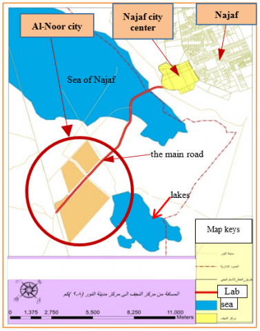
Source: Researchers worked using GIS software
Figure 1. The location of al-Noor City in relation to the city of Najaf
Source: Researchers worked using GIS software
Figure 2. The touristic areas in Al-Nour district
6.1 Residential characteristics of the city
Allocated 18,679 separated residential plots with areas ranging between 250 m2 - 350 m2 with title deeds issued by the Real Estate Registration Department in the governorate. Through the field study, it was found that the benefit of these lands amounted to (845) plots of land for the construction of habitable and occupied housing units until the preparation of this study is (263) housing units only, which is a very small percentage if compared to the number of plots of land granted for residential use, which is approximately (16443) pieces of land. Which gives us a clear picture of the reluctance of the owners or owners of these lands to construct housing units and settle and live in the city, which makes these lands untapped resources and did not achieve the goal for which those allocations were made [10].
6.2 Population characteristics
The population of the city of Al-Noor at the time of preparing this study is about 2060 people, comprising of 287 families, most of whom were residents of the city of Najaf, where they lived in rented units or in slums located in the south and southwest of the city of Najaf and of different clan origins.
Most of the population are low-income people who occupy simple, unstable professions, such as construction workers, guards, agriculture, etc., and the percentage of these, according to the field study of the research team, reached 87% of the population.
The percentage of working women as well as those with a university education represents about 1% of the population, according to the sample that was surveyed by the research team.
The unemployment rate reached 38% in the study area, according to the aforementioned sample.
The percentage of economically active people in the study area reached 64% of the population.
The percentage of children who do not attend school for economic reasons is 18%.
The social and economic relations between the city of Al-Nour and the surrounding villages are very weak, and they are more closely linked to the city of Najaf in economic and social terms [10].
6.3 Features of public services
6.3.1 Education services
The educational sector occupies an area of 850,514 hectares, which includes various services, starting from nursery schools, primary schools, middle schools and secondary schools, with a number of 192 planned educational facilities [11]. As for the outlet, it is two schools, one for primary studies and the other includes primary and intermediate studies at the same time.
6.3.2 Health services
Al Noor City contains two health centers with an area of 168.57 square meters. One of them has been implemented and activated and the other is not implemented. Religious - commercial - entertainment - security services: Al-Noor City contains two mosques, one of which is activated and is the “Great Prophet (PBUH)” mosque, and the other is unused.
Al-Noor City lacks markets, despite the allocation of space for more than 27 commercial sites. The residents depend for their needs on the “Souq al-Hadiqa” in the center of Najaf. As for small shops, the number of small shops does not exceed 5 shops in the Darsa site [12].
As for the recreational aspect, it includes both public parks and green areas, as it contains al-Noor City is on 2 parks with an area of 14800 square meters for each park and 40 green areas with a total area of 36000 hectares. However, it is not implemented at the time of preparing this study.
As for the security aspect, Al-Nour City does not have a police station, as we find its residents suffer from insecurity due to frequent thefts, as the percentage of the residents who lost their sense of safety in Al-Nour City amounted to 66% of the sample taken.
6.4 Infrastructure services
6.4.1 Water network
Al Noor City contains an integrated and hierarchical water network, whose lengths range from 142.5 meters in the first part to 806 meters in the low-cost floors, and it is active at the present time [13].
6.4.2 Electricity network
Al Noor City contains an integrated electricity network that covers all parts of the city and serves the largest number of distributed plots, and is currently activated in the first part and in the second part by 70%. And there is a project to transfer electricity to the electricity network from Al-Shurta neighborhood in the city of Najaf, which has recently been completed and activated.
6.4.3 Communication services
There are no exchanges in Al Noor City at all, and there are absolutely no call or postal booths. As for the existence of private communication towers, there are only four mobile phone companies [14].
6.5 Economic characteristics
6.5.1 Agriculture
Al Noor City is characterized by scarcity of water and salinity because it contains sodium chloride salts, which makes its land unsuitable for agriculture. Also, most of the residents of Al-Noor city do not work in agriculture, as the number of farmers in the city of Al-Nour is 195 out of 1873, where they constitute 10% of the sample taken at the study site. These farmers work in the nearby agricultural lands. These agricultural areas are famous for a number of crops such as (celery - leeks - tomatoes - eggplant - radish - cucumber - onions - okra - alfalfa - jet - cress) and wild plants such as (olives - palms - willow - figs - arrowroot). Al-Aqoul - Al-Turfa - Al-Kurt - Thistle - Handal - Al-Halfa) with a large number of preparations [14].
6.5.2 The tourism side
Al-Noor city contains tourism elements that enable it to activate this aspect represented by the Najaf Sea, which is bordered by the north, and the lake that borders it from the south and the north coast, which is bordered by Al-Najaf to the north.
6.5.3 The industrial side
In Al Noor City, there is no industrial activity except for a few small workshops. In the vicinity of the city, there are a few industries represented by brick factories, quarries, a natural gas plant, solar water purification plants, and a cement plant, which provide job opportunities for 103 people, only 10% of whom live in the city [15].
The research adopted the method of quantitative analysis of the characteristics of the Al-Nour City through the SWOT matrix (elements of strength and weakness) and (elements of opportunities and threats). Aspects, challenges and service aspects). And then deducing the private and general objectives on the basis of which strategies are formulated that make the Al-Nour City attractive to the population in light of the capabilities and resources available in it. This can be explained through the following Tables 3, 4, 5, 6, 7.
Table 3. Analysis of demographic and residential characteristics
|
Strength point |
|
|
Weak points |
|
|
Opportunities |
|
|
Threats |
|
Table 4. Analysis of services
|
Strength point |
|
|
Weak points |
|
|
Opportunities |
There are some financial allocations that have been fixed within the Najaf governorate budget for services in the city of Al-Nour |
|
Threats |
Weak investment activity in the services sector for the city of Al-Nour |
Table 5. Analysis of economic
|
Strength point |
|
|
Weak points |
|
|
Opportunities |
|
|
Threats |
|
Table 6. Analysis of transport
|
Strength point |
|
|
Weak points |
|
|
Opportunities |
|
|
Threats |
|
Table 7. Analysis of environmental
|
Strength point |
|
|
Weak points |
|
|
Opportunities |
|
|
Threats |
|
The studied city contains a lot of development elements that can, through its revitalization, attract a large number of residents, in addition to a set of problems that negatively affect the process of attracting residents, which require a set of strategic planning treatment to improve the reality of this city, the most important of which are:
The presence of a large stock of residential plots for people with limited income.
Availability of good infrastructure services such as electricity, water and communications networks, in addition to public services, especially health and education, despite their inconsistency with the needs of the population.
The existence of a road linking the Al Noor City and the city of Najaf on the one hand, and between it and the neighboring villages on the other hand.
Availability of agricultural and industrial ingredients, especially (food and construction industries), such as the cement and brick industry, due to the availability of raw materials for these industries.
It provides the city's tourism potential due to its direct proximity to the Najaf Sea and some of the eastern and northern side, and its proximity to some natural lakes from the southern side. In addition to its proximity to the Najaf desert towards the west, where tourism is active in hunting birds and wild animals during the spring season.
The city, through the villages and its neighboring regions, possesses religious tourism resistances, represented by a number of religious shrines and the old pilgrimage road (Zubaydah Road).
The presence of some industrial and agricultural projects close to the city that provide good job opportunities for the city’s residents, such as the Kara Cement Factory and vegetable and grain farms in the northern part of the city.
The city suffers from a lack of government and private investment in the field of public services, industry, agriculture, energy and tourism, which affects the quality of life of the population on the one hand and the scarcity of job opportunities on the other hand.
The city suffers from a low level of education for the population in general, and women in particular, and a high percentage of children who have dropped out of school, in addition to weak social ties between the residents of the city and its neighboring villages. The population lacks a sense of safety.
The presence of air pollution resulting from the brick factories near the eastern side of the city, which use old polluting methods, with the absence of strict environmental control by the Environment Department in Najaf Governorate.
The absence of serious solutions to the problem of the solid waste dump near the southeastern side of the city, which significantly affects the residents of Al Noor City.
9.1 Recommendations for population and residential use
Working to provide economic activities (industrial - tourism - agricultural - commercial) that would provide attractive job opportunities for the population.
Increasing the cultural awareness of the population, paying attention to the role of women and children, and preventing students from dropping out of school.
Developing solutions to the problem of unexpected floods that raise the concerns of the population through an irrigation project and natural reservoirs to which torrential waters are diverted, or by extending irrigation channels that end in the Najaf Sea, in addition to strengthening security aspects, combating crime, increasing electronic monitoring, and distributing police stations in the vicinity and within the city.
Providing support from government and private banks and setting incentives for investors for their activities related to housing projects and human development.
9.2 Recommendations for the establishment and service activities in the city
A timetable must be set for the implementation and activation of the services planned by the Reconstruction Council in the governorate, especially water and energy services.
Executing and equipping a public hospital in Al-Nour City as soon as possible, and not being satisfied with the existing health center, which does not meet the requirements of the population.
Separation of the dual uses of the areas (playing yards - sports arenas).
Increasing banking facilities and loans to stimulate and attract investors in the field of service projects.
9.3 Recommendations related to the economic aspect of the city
Establishing vocational educational centers that would produce effective professional cadres in the industrial, agricultural and tourism fields.
Supporting the supportive media side to show the development potential of Al-Noor City in the economic aspects.
Amending the National Investment Law to help attract investors, merchants, and capital to this city and other affiliated cities or new cities, in order to invest their potentials and thus develop the housing and services sector.
9.4 Recommendations related to the transportation aspect in the city
Establishing a road around the city with high technical specifications to accommodate the movement of various modes of transport, especially large trucks, that enhances functional interdependence with the city of Najaf from the east and the villages from the west.
Paving the main dirt streets in the short term and allocating streets for pedestrians and bicycles in the medium and long term.
Paying attention to street furniture and landscaping with types that fit the natural environment of the area.
9.5 Recommendations related to the environmental aspect
Establishing a sustainable solid waste plant in the eastern part of the city to get rid of the waste problem on the one hand and generate energy on the other hand, thus protecting the city's environment from pollution. In addition to the economic benefit and the provision of job opportunities.
Establishing a green belt surrounding the city, especially in the northwestern part where the prevailing winds are to avoid dust storms, and from the eastern southern part to avoid air pollution and unwanted winds.
Enhancing governmental efforts and local and regional environmental protection organizations to protect the biodiversity of the Bahr al-Najaf area adjacent to the city of Al-Nawraz, thus enhancing the environmental and tourism aspects of the city.
Investing the developmental potentials for the development of religious tourism in the village of Al-Rahimiyya.
Investing in the development potentials for the development of the food industry and residential use in Al-Qadisiyah sub-district of Al-Manathira city.
[1] Md. Mehedi, H., Md. Shamsul, H. (2016). Developing Satellite towns: A solution to housing problem or creation of new problems. International Journal of Engineering and Technology, 8(1): 50-56. https://doi.org/10.7763/IJET.2016.V6.857
[2] Jasim, I.A., Farhan, S.L, Al-Maliki, L.A, Al-Mamoori, S.K. (2021). Climatic treatments for housing in the traditional Holy Cities: A Comparison between Najaf and Yazd Cities. IOP Conference Series: Earth and Environmental Science, 754: 16-17. https://doi.org/10.1088/1755-1315/754/1/012017
[3] Golany, G. (1976). New Town Planning Principles and Practice. John Wiley & Sons, London.
[4] Ibrahim, A.B. (2020). The experience of new cities in Egypt depicts the theory in the absence of a national settlement strategy. High Commission for Planning, Egypt. http://www.10thonline.com/2014/01/map-10th-of-ramadan-city.html.http://www.cpa, accessed on Jan. 1, 2023.
[5] Aqaba community and economic development (aced ii) program final report. https://pdf.usaid.gov/pdf_docs/PA00KBNV.pdf, accessed on Dec. 12, 2022.
[6] https://en.wikipedia.org/wiki/Aqaba, accessed on Dec. 9, 2022.
[7] Farhan, S.L., Jasim, I.A., Almamoori, S.K. (2000). The transformation of the city of Najaf, Iraq: Analysis, reality and future prospects. Journal of Urban Regeneration and Renewal, 13(2): 160-171(12).
[8] Al-Tamimi, A.H., Alnasrawy, A.A.M., Al- Hatmi, M.H., AL-Ansari, N., Al-Mamoori, S.K., Jiddy, Z.A.J. (2022). Urban uses change an analytical study using geographic information systems Kufa city as a model. Civil & Environmental Engineering, 9(1). https://doi.org/10.1080/23311916.2022.2143065
[9] Jasim, I.A., AlMaliki, L.A., AlMamoori, S.K. (2022). Water corridors management: A case study from Iraq. International Journal of River Basin Management, 1-11. https://doi.org/10.1080/15715124.2022.2079662
[10] Maner, Ç., Zaina, F. (2020). Preliminary results of the Land of Kufa survey project (Najaf governorate, Iraq). https://www.academia.edu/attachments/79077473/download_file?st=MTY3ODM1NDgwMCwyMDMuOTEuODUuMTAx&s=swp-splash-paper-cover, accessed on Dec. 11, 2022.
[11] Farhan, S.L., Alyasari, H.I., Akef, V.S., Zubaidi, S.L. (2021). Analyzing the Transformed Urban Patterns of Al-Najaf Historical Center: Urgent Issues and Possible Solutions. IOP Conference Series Materials Science and Engineering, Psychosocial Journals, 1058(1): 012052. http://dx.doi.org/10.1088/1757-899X/1058/1/012052
[12] Shabaa, M.J., Abas, A.Y.A. (2020). Development of Health Services in Al-Najaf ‘‘Al Ashraf’’ Governorate-Iraq. 24(4): 2427-2441. https://www.psychosocial.com/article/PR201351/12264/, accessed on Sep. 12, 2022.
[13] Hussein, A., Ayad, K., Uday, A., Mohammed, S. (2020). Water quality status of euphrates river in Al-Kufa station. Journal of Green Engineering, 10(7): 3914-3931. https://www.iasj.net/iasj/pdf/8735cea7e0645bc4, accessed on Dec. 10, 2022.
[14] Taha, S. (2018). Sustainable development of agricultural land Najaf Governorate. In specialized scientific conference (geography and history meet in space and time).
[15] Hamem, H., Khauon, A., Hasan, S. (2020). The Infrastructure and the Potential of the Tourism Industry in the Holy City of Najaf. https://jpd.uobaghdad.edu.iq/index.php/jpd/article/view/293, accessed on Sep. 11, 2022.