Diala Atiyat
© 2022 IIETA. This article is published by IIETA and is licensed under the CC BY 4.0 license (http://creativecommons.org/licenses/by/4.0/).
OPEN ACCESS
The study provides a better understanding of how city inhabitants perceive and navigate their surroundings hence the urban environment consists of both physical elements and mental representations. The study objective is to review the concept of the image of the city and its implementation in Downtown Amman - Jordan using the descriptive-analytical methodology in addition to site visits and observation that provides a detailed urban mental map for Downtown Amman illustrated by the different layers of the urban fabric. the study shed light on three components of the city image: Identity (the recognition of urban elements as distinct entities), structure (the relationship between urban elements and the observer), and meaning (the relationship between urban elements and the emotional value for the observer). By summarizing the analysis of the downtown Amman image, a visual representation of what appear to be the key issues in the city image. The analysis shows problems such as "Break of continuity", "Branching" and "Lack of integration" have appeared due to the lack of clear organization of the shape of the city facades and the way signs are placed, as well as the mixing of pedestrian paths with vehicles traffic.
city structure, city identity, city meaning, mental maps
A legible mental map provides a critical sense of emotional security, serves as the basis for conceptual organization and communication, and heightens the richness and intensity of daily life. A thorough mental map of the urban environment is necessary to combat the rising threat of disorientation - paper issue. Kevin Lynch’s theory of “the image of the city applied to Downtown Amman through studying the city’s identity, meaning, and structure.
1.1 Methodology
The study adopts a mixed methodology: data collection: Literature review; books review, papers review, review of previous studies, Internet, photographic documentation, analysis of collected data in addition to observation and field visits for the case study “Downtown Amman”. Lynch’s city components of an environmental image (city practical and emotional value to the observer) had applied to the case study. (Figure 1).
Figure 1. Methodological framework
The richness and intensity of everyday human experience are increased by having a readable mental map, which also acts as a foundation for communication and conceptual structure. Lynch claims that this makes the city a compelling representation of a sophisticated society. The three aspects of an environmental image are identity (the recognition of urban elements as distinct entities), structure (the relationship of urban elements to other objects and the observer), and meaning (the relationship of urban elements to the observer) (its practical and emotional value to the observer) [1].
Kevin Lynch, introduced in his book “The Image of the City” the term imageability which means a property of a physical object that is likely to evoke a strong image in a particular viewer. This shape, color, or arrangement facilitates the creation of a recognizable, highly structured, highly useful mental image of the environment [1].
Lynch's goal was to emphasize how the imageability and characteristics of the urban environment affect the mental mapping of someone traveling through the city. He studied the experiences of people in three cities in the United States. Boston, Jersey City, Los Angeles. Concluding that he understands the surroundings predictably and consistently.
Previous studies [1-5] dealt with many examples of the application of Kevin Lynch's concept of the image of the city theory, but none of them mentioned the application of this concept at the level of a city in Jordan. This study shed light on three components of the city image: identity structure and meaning.
2.1 Downtown Amman identity
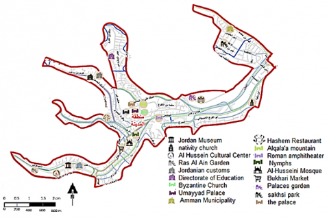
Amman, the capital of Jordan, is made up of seven hills that are, on average, 750 meters above sea level. The hills in the area rise to a maximum elevation of 918 meters above sea level [6]. Jordan has more than ten million residents, and the capital city, Amman, has four million residents and a land area of 7579 km2 [6]. Downtown Amman is located in the heart of the capital Amman and is the nucleus of the city and the historic region.
Downtown Amman has always been distinguished by its cultural sites, from its architectural character, which includes heritage houses, cafes, and old cinemas to bookstores. In recent years, many heritage houses have been re-used in restaurants and cafes to be the centerpiece of cultural activities and gatherings. The Greater Amman Municipality also promoted cultural heritage in downtown Amman and organized concerts in archaeological sites such as the Citadel and the Roman Amphitheater in cooperation with the Ministry of Tourism under the name of the Amman Summer Festival [7].
The character of the place is influenced by its identity which is formed by its response to various factors including population, culture, and the environment, so retaining the originality of the place is the basis when implementing any project related to heritage. Downtown Amman is distinguished by its distinctive horizontal landscape. it is characterized by low-rise buildings built of stone with concrete and resided by the population of middle to low income [8].
2.2 Downtown Amman structure
Lynch contends that a city's public perception is made up of numerous overlapping individual representations. Paths, edges, districts, nodes, and landmarks are the five categories Lynch used to categorize the components of the city image structure [9].
The routes that guide a visitor to the city are called paths. They could be railroads, canals, or streets. Paths are continuous, linear channels. They are crucial because how people move while walking affects how the city is viewed.
An edge is a line between two phases. Edges are linear components, such as those between a city and the sea. A phase's continuity was broken by the edges opposite the pathways, and a new phase started from the edges [9]. The districts are the city's subdivisions. Different physical characteristics, such as texture, space, form, detail, symbol, building type, usage, activity, population, degree of maintenance, and geography, can be used to designate districts. They may be related to one another, or they may be standing alone in a distinct area.
Nodes are the tactical locations that an observer can penetrate to access path intersections or concentrations of a certain attribute.
Landmarks are the final component. Observers cannot enter the landmark, unlike nodes. In the city, they are typically clearly defined, uncomplicated items. Buildings, signs, shops, or mountains can all be examples [9].
2.2.1 Paths
Pedestrian paths in downtown Amman are defined by the sidewalks accompanying the streets, ranging in width between 2m to 4m. There is a discrepancy in the characteristics, quality, and manufactured materials. There are no paved paths that cars are not allowed to enter (Figure 2). As for the vehicles, the streets varied between main and secondary streets, connecting the area with the surroundings. The streets are for private cars, public buses, and taxis. width of streets varies from 15m to 33m.
Figure 2. A concuptual sketch for “Downtown Amman” Paths
2.2.2 Nodes
Nodes vary between being a gathering place for people like “downtown Amman Center” or a square like “The Hashemite Square” or even a Bus station like “Ragadan station”. The main street intersections in downtown Amman form important Nodes such as the "Basman St - Reda St" intersection and the "Ragadan Station - Alhashmi St" intersection (Figure 3).
Figure 3. A concuptual sketch for “Downtown Amman” Nodes
2.2.3 Landmarks
There are many landmarks in downtown Amman, whether they are antiques “the Nymphs’ Path”, heritage “Hashem Restaurant”, or modern landmarks such as the “Jordan Museum” and the “Nativity Church”, down to the distinctive green areas Like “Al Hashemi Park” (Figure 4).
2.2.4 Edges
Since downtown Amman is originally a low-level area surrounded by mountains, the border signature came on the same boundaries of the study area with the presence of some internal boundaries, which were classified into: unpleasant, moderate, and strong (Figure 5). The strong edge is visually prominent, continuous in shape, and impenetrable for cross-movement, as the unpleasant edge is the opposite of the strong edge in which the mental image of the observer is cut off and the Moderate edge is located between the unpleasant edge and strong edge.
Jabal Al-Joufa and Jabal Al-Ashrafiyah Edge: Downtown Amman is bordered in the south by Jabal Al-Joufa, Al-Ashrafiya, and Al-Wihdat, and its length is (3.63 km), which is the longest Edge (Moderate Edge).
- Alhashmi and Altaj Edge: Located on the eastern side, with a length of (7.51Km) (unpleasant Edge).
- Jabal Alqalaa Edge: Located on the northeastern side of the study area with a length of (1.85 km) (strong Edge).
- Jabal Al-Hussein Edge: Located on the northeastern side of the study area with a length of (1.34 km) (Moderate Edge).
- Jabal Weibdeh Edge: Located on the western side of the study area with a length of (1.41 km) (Strong Edge).
- Almuhajereen Edge: Located on the western side of the study area with a length of (1.90 Km) (unpleasant Edge).
Figure 4. A conceptual sketch for “Downtown Amman” Landmarks
Figure 5. A conceptual sketch for “Downtown Amman” Edges
2.2.5 District
The division of the districts was based on the parts that contain a group of buildings of the same character in the first place and the same usage description in the second place.
The residential areas branched out more because they contain wide differences in the quality of construction, the way buildings are distributed, and the architectural style scattered over them.
As for the commercial areas, they differed in the quality of service and the variety of materials used, and there was a difference in character as well, but it was clearer in the residential areas.
Also, some neighborhoods were distinguished by the abundance of the green element and its sudden interruption.
2.3 Downtown Amman meaning
City meaning studies and analyzes submissions that focus on the perceptual felt characteristics of urban environments, such as experiential, emotional, sensory, and affective dimensions that contribute to how people behave in, feel about, and move around the city [10].
Joy, fear, pride, nostalgia, disgust, or other individual and shared feelings can form the meanings ascribed to downtown Amman. Even living experience and emotional connections to urban spaces in downtown Amman determine the way certain spaces are preserved and memorialized or demolished and redeveloped.
The origins of the population in downtown Amman vary, and that is what distinguishes it from other Jordanian cities. When it was chosen to be the capital in 1921, the population began to come to it from all directions. This contributed to enhancing diversity in all aspects, which naturally includes diversity in the architectural aspect and the formation of a sensory experience for the residents according to the interaction between them and the built environment that they created. The stairs constitute the main link between the horizontal streets, according to the mountainous nature of downtown Amman, and these zones were places for gathering and exchanging dialogues. The shape of the cluster buildings sloping on the mountains formed urban communities based on the unity and harmony between the neighbors and, of course, the feeling of safety [11, 12].
The feelings of the people in the city have always played an important role in forming a clear image of the city based on their own experience and their close relationship with cultural and historical places, which later determined the way to deal with certain areas within the city and how to Rehabilitate or create them [13-15].
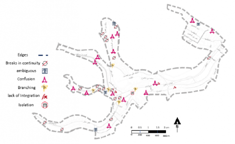
The formation of a mental map of the city could be figured out through its visual contrasts and sense of motion, which are playing an important role in forming an integrated image of the city. Sense of motion and visual contrasts were validated by comparing the observations with Lynch’s visual representation of what appear to be the key issues in the city image, such as lack of integration, confusion, weak boundaries, isolation, breaks in continuity, ambiguities, branching, lack of character, and lack of differentiation (Figure 6).
One of the most noticeable things while touring downtown Amman is the presence of several areas characterized using different materials for buildings Most of the buildings in Downtown Amman are multi-story and were built over more than one period of time. All of this contributed to the different facades of the buildings in terms of shape, architectural style, colors, and materials, whether they were stone, brick, or concrete this contributed to the cut of continuity and observer visual contact with the surroundings (Figure 7).
The disparity in the heights of buildings despite the presence of laws and legislation specific to the region, and the difference in architectural styles with the presence of shop signage, constitutes a kind of visual pollution of the street facade (Figure 8).
Figure 6. A conceptual sketch for a visual mental map of “downtown Amman”
Figure 7. Confusion “downtown Amman”
Figure 8. Breaks in Continuity “downtown Amman”
Branching could be observed clearly in the presence of more than one point of contact with the main streets such as the intersection of Faisel St - king Hussien St and the intersection of King Faisel St - King Talal St (Figure 9).
As for confusion, it is clear in the encroaching on pedestrian paths and street borders from the owners of the stalls and even the owners of the shops, who used them to display their merchandise.
Lack of integration appears at the level of a single building and the street level or the district level. There is a clear discrepancy in the window openings on the facades and the different features of each floor, both in terms of old and modern building materials and the inconsistency of the street width with the height of the buildings. The lack of sufficient pedestrian crossing paths led to the formation of an incomplete spatial experience for the city users, in addition to the disappearance of the green elements such as trees and green roofs -façades that are considered an important element in the city’s visual composition (Figure 10).
Figure 9. Branching “downtown Amman”
Figure 10. Lack of integration “downtown Amman”
The most distinctive feature of the downtown Amman Image is the surrounding natural edges since the study area is surrounded by mountains, where the longest Edge is the "Aljoufah and Alashrafieh Edge" with 3.63 km.
This difference in topography has formed what is called "Ambiguous", which affects the formation of a clear mental image of downtown Amman.
The districts range from mixed-use areas to residential and commercial areas. As for the landmarks, they were many since the area is historical and archaeological par excellence.
Most of the Nodes were intersections of major streets due to the nature of the spatial planning of the study area.
Problems such as "Break of continuity", "Branching" and "Lack of integration" have been deducted due to the lack of clear organization of the shape of the facades, as well as the mixing of pedestrian paths with vehicle traffic, which causes an unpleasant experience for pedestrians.
This study is limited to a specific area, which is Downtown Amman, and it cannot be generalized, but the results can be used to develop Amman city center in the future in terms of urban planning.
It is possible to conduct future studies on a larger scale in Jordan and take the entire city of Amman and work on developing urban planning based on the experience of the residents, to reach results that can be generalized to central cities in the middle east.
[1] Lynch, K. (2015). The City Image and Its Elements. In The City Reader, Routledge, 620-630. https://doi.org/10.4324/9780429261732-67
[2] Filomena, G., Verstegen, J.A., Manley, E. (2019). Acomputational approach to ‘The Image of the City’. Cities, 89: 14-25. https://doi.org/10.1016/j.cities.2019.01.006
[3] Huang, J., Obracht-Prondzynska, H., Kamrowska-Zaluska, D., Sun, Y., Li, L. (2021). The image of the city on social media: A comparative study using “Big Data” and “Small Data” methods in the Tri-City Region in Poland. Landscape and Urban Planning, 206: 103977. https://doi.org/10.1016/j.landurbplan.2020.103977
[4] Rathnasekara, S.N., Munasinghe, J.N. (2021). Sustaining the image of the city: What matters more? An investigation in the city of Colombo. FARU Journal, 8(1): 24–34. http://dx.doi.org/10.4038/faruj.v8i1.60
[5] Alamoush, S.J., Kertész, A. (2022). Imageability of cities in regards of attractiveness: A case of Salt City in Jordan. Pollack Periodica, 17(1): 168-172. http://dx.doi.org/10.1556/606.2021.00385
[6] Ashour, K.N. (2016). Urban regeneration strategies in Amman's core: Urban development and real estate market. Doctoral Dissertation.
[7] Abu-Awad, B., Abu-Hammad, N., Abu-Hamatteh, Z. (2019). Urban and architectural development in amman downtown between natural disasters and great heritage lose: Case study. International Journal of Architecture and Urban Development, 9(3): 31-38. https://doi.org/10.1001.1.22287396.2019.9.3.4.6
[8] Gharaibeh, A.A., Al. Zu’bi, E.A.M., Abuhassan, L. (2019). Amman (city of waters); policy, land use, and character changes. Land, 8(12): 195. http://dx.doi.org/10.3390/land8120195
[9] Lynch, K. (1960). The Image of the City. The City Image and Its Elements, 1st ed MIT Press, 46-91. https://doi.org/10.1177/000271627642500132
[10] Municipality of Greater Amman. Open access files, Amman Jordan. https://www.ammancity.gov.jo/ar/main/index.aspx, accessed on Jan. 12, 2022.
[11] Shehata, A.M. (2022). Current trends in urban heritage conservation: Medieval historic Arab city centers. Sustainability, 14(2): 607. http://dx.doi.org/10.3390/su14020607
[12] Matošević Radi, M., Ivona Jukić, I., Roje, A. (2020). Increasing tourism through social entrepreneurship – the case of Croatia. The Journal of Corporate Governance, Insurance, and Risk Management (JCGIRM), 7(1): 25-38. https://doi.org/10.51410/jcgirm.7.1.3
[13] Acikalin, S., Yildirim, H.H. (2021). Comparison of banks with cluster analysis before and after COVID-19 Pandemic. The Journal of Corporate Governance, Insurance, and Risk Management (JCGIRM), 8(2): 185-196. https://doi.org/10.51410/jcgirm.8.2.13
[14] Goussous, J.S., Al-Hammadi, N.A. (2018). Place attachment assessment of a heritage place: A case study of the Roman amphitheater in downtown Amman, Jordan. Frontiers of Architectural Research, 7(1): 1-10. https://doi.org/10.1016/j.foar.2017.12.001
[15] Low, S.M., McDonogh, G.W. (2001). Introduction to "remapping the city: Place, order, and ideology". American Anthropologist, 103(1): 5. https://doi.org/10.1525/aa.2001.103.1.5