Mazin Jaber Omar | Emad Hani Ismaeel | Faris Ali Mustafa*
© 2022 IIETA. This article is published by IIETA and is licensed under the CC BY 4.0 license (http://creativecommons.org/licenses/by/4.0/).
OPEN ACCESS
According to UIA-CIMES Declaration, several governments have included a group of intermediate cities in their program for sustainable urban development. In third world countries, many of these urban areas still suffer from neglect and shortcomings in the production process of well-thought-out urban expansion plans, regardless of their capacity and potential for urbanization and transformation. This research aims to take advantage of the digital capabilities of GIS software to study the most effective factors in formulating urban expansion plans necessary to develop appropriate policies for intermediate cities from the perspective of UIA-CIMES. Its methodology focuses on identifying a range of factors affecting the development of the master plan for these cities, including identifying many aspects related to sustainable urban development such as cultural, physical, economic, and environmental aspects, with their details and land uses, besides determining several urban factors and indicators approved for differentiation and classification of expansion areas. This is followed by an analytical study of the Idrisi program on the city of Sinjar in northern Iraq as a case study to provide a comprehensive view of the urbanization of the city in a long-term GIS plan. Idrisi is characterized by its ability to deal with raster images more than vector graphics, and the ease of working and training. After extracting the results, planning trends are analyzed and identified to show the appropriate land use for each of the mentioned expansion areas. These results are available to the decision-maker in formulating the scenario of the new master plan for Sinjar city 2040. The analysis of the potential expansion areas utilizing Idrisi has revealed the existence of two types of regions in Sinjar: basic expansion zones and non-basic expansion zones, and the study of its future expansion must be based on the principles of sustainable urban development according to long-term planning.
urbanization, GIS, long term, sustainable development, intermediate cities, UIA-CIMES, Sinjar city
Intermediate cities are considered an important product within human settlements, due to their work - by the network of regional relations - as a tangible link, economic and social interaction between other metropolitans, urban and rural communities (capitals, metropolis, big cities, small cities, towns, villages, etc.). In addition, by their urban fabric and natural elements, these cities represent real social and historical resources, which make the process of developing this type of urbanization a critical and problematical issue. According to the “UIA-CIMES Declaration”, governments have included a group of cities in its program, with the goal of sustainable urban development for this category of cities [1].
This declaration draws attention to the intermediate cities' task in the process of global urbanization. It underlines the essence of society implications influence of urban design on the evaluation of cities' development. In the context of intermediate cities, the attempts to realize innovative methods to overcome urbanization problems are the key social and practiced questions. Currently, intermediate cities participate in getting a more sustainable process of urbanization; founding further relations with their economic and social neighboring regions; allowing a better public involvement in the city management and its resources [1]. Despite the suitability of many of these urban areas located in the third world countries for urbanization and transformation into large cities due to their urban, social, and natural potentials, many of them still suffer from neglect and shortcomings in the process of producing studied urban expansion plans. This research aims to clarify the most effective factors in the formulation of urban expansion plans and urban decision-making required to develop policies appropriate for intermediate cities from the UIA-CIMES perspective.
The research methodology includes a theoretical framework that focuses on identifying a set of qualities influencing the Master Plan development and urban expansion of the intermediate cities, with identifying the common factors with the predominant effect on various cities. Then, carrying out an analytical study using GIS for an intermediate city-Sinjar City in northern Iraq as a case study - for presenting a procedure that enables planners to provide a comprehensive view of the city's urban expansion long-term plan Sinjar2040.
2.1 UIA-CIMES program
The United Nations conference on human settlement (Habitat II) in Istanbul in 1996 with the Congress of the International Union of Architects – UIA in Barcelona in 1996, established the global considerations on the role of the intermediate cities and their responsibilities in the process of global urbanization, comprising the Intermediate Cities and global urbanization program [2].
The UIA-CIMES Declaration draws attention to several aspects. Article 1.2 emphasizes the essence of society implications impact of urban design and planning on the assessment of cities' speedy growth, which is a present international concern related to the important progress of economic actions from the rural area to the city, furthermore with the urban inhabitants growing. Urban planning will witness massive agglomerations and large cities that will congregate additional inhabitants with the need of services more than the capacity of their infrastructure, which requires an enhanced management urban system, with minor, improved distributed, and more decentralized settlements [1]. From their perspective, architects and urban planners have to investigate the ways of dealing with and solving the problems initiated by the inhabitants increasing concentration, finding means of providing them with an appropriate structure to exploit human activities [1].
2.2 The intermediate city
In 2000, more than three billion of the world's population reside in urban areas [2]. According to the United Nations Studies Report, internationally, more population inhabit urban regions than in rural regions, with 55% of the world’s population residing in urban zones in 2018, which will be 68% by 2050 [3]. The UIA-CIMES International Work Program aims at sustainable development of intermediate cities and finding solutions to housing, infrastructure, urban heritage, and other problems. To define the “intermediate city”, it is not enough to simply consider its demographic intensity or its physical size but to take into consideration its roles, the level of impact it plays, and the social, economic, and cultural interactions in its surrounding territory; the settlement that presents services for the residents of its areas of influence as well. It is a critical component of infrastructure networks that links local, provincial, and possibly national systems, which perform as a route for the feedback process [4]. Its degree of non-central public management and involvement causes more understanding of the developed regions, assisting to formulate real measures of the requirements of any individual urban environment [1]. “Intermediate cities” CIMES typically show a distinguished functional complexity, own a considerable level of centrality and have historic and architectural structures and represent critical points within their area. Within the comprehensive urban system, they form accessibility to other settlement cores.
CIMES forms better sustainable systems with further harmonic, open, and balanced relationships with the neighboring areas. In developed countries, several cities utilize the natural and human resources of the considerable rural areas located in their influence area. It is simpler to make or build up its specific identity, which is convenient, distinguished by the residents. Such a type of city is characterized by fewer social clashes, minor social costs, and less cultural diversity, furthermore less access to the basic sources of information and funds. It regularly depends upon a particular economic district. It has fewer environmental issues detected in large metropolitans [1].
Often CIMES are influenced by their surrounding economies, which include diverse types of rural and informal economies. On worldwide scope, the intermediate city has between 20,000 and 2,000,000 inhabitants, and be supposed to play a comprehensible territorial function with several managerial tasks at the national, regional, or local degree, and should not form a section of metropolitan settlements [5]. Besides its investment in rural and agricultural areas and human resources within its regions, its ease of management and the ability of citizens’ participation, intermediate cities are also distinguished from the large Megalopolis by being less suffering in terms of environmental problems and more widespread in the human scale and they are less demographically and culturally diverse and more socially close, but they are less flowing in information and capital [6]. They are well placed to create the link between central authorities, urban areas, and rural districts. These cities' evolution is a clue that such enters perform as stopping districts for traveling people on their path to large cities [7].
2.3 Promoting intermediate cities motives
National and international organizations and administrative bodies offer insufficient awareness of CIMES. CIMES play a crucial task in the process of international urbanization, since they globally accommodate a great part of inhabitants, and they institute further balanced and sustainable urban structures, they still receive less consideration from professional and experts’ domains. Regarding CIMES, the specific research and specialized studies have not been compared to their weight and importance [5]. CIMES require greater political and administrative decentralization, to give local agencies wider authorities and duties. Professionals and specialists need to raise attention to CIMES's particular difficulties and distinctiveness and their surroundings [5].
Due to current economic globalization transformations and urbanization progression and the intermediate cities role played in different environments, it is important to argue for various practices in the promotion of intermediate cities and territorial decentralization, to provide knowledge interaction tool linking specialists and public authorities that possess the same difficulties to handle [1]. As a policy to support decentralized evolution, the UN-Habitat in 2015 calls national organizations to encourage the role of rural service centers, and intermediate cities to draw populations, expend funds and decrease dependence on Large cities [8].
To exploit the economic urbanization advantages, urban planners must make the most out of the small and intermediate cities [9]. In developing countries, the unrestrained urbanization increment necessitates urgent actions to guarantee that the urbanization profits are achieved without producing environmental or social deterioration.
2.4 Urban plan policies and long term projects
Strategic planning is required to frame long term projects for city development in that it generates a common framework to enhance urban policy and to permit public and private urban bodies; it must correspond with city planning, urban development, and architectural interventions; and, it allows wider public participation by producing construction and a mutual ideal [10]. Medium and long-term city planning is a fundamental factor in improving urban policy for CIMES. Urban plans must improve innovative solutions to contemporary challenges and override the technocratic utilization of «zoning» by encompassing the benefits growing at the intermediate level of urban planning [5]. Urban development plans must support and apply the environmental advantages of cities [11]:
2.5 Questions and issues affecting the traditional urban patterns
As stated by UNESCO, the issues affecting the traditional urban pattern should be inspected at several levels: Social Fragmentation Issues, due to socio-economic and cultural inequality; Urban Identity Issues, conventional social relations within cities, neighborhoods, and specific housing units; and Governability Issues: caused by the separation between social communication representatives and forms of political representation. General hypotheses can be evaluated as follows [5]:
Intermediate cities diversity: depends on the various conditions and environments related to the urban context, they extend between the low-density cities to very high-density cities.
The influence regions: In developing urban policies of the intermediate cities, the intervening task imposes taking into consideration their influence relevant areas.
Means of transportation: Intermediate cities attend to be situated at good intersections of terrain communications, with satisfactory access to the transportation systems.
Urban amenities and services: which should take into account the influencing related areas of the city in addition to covering the requirements caused by municipal service sectors.
Housing: In intermediate cities, sub-standard, marginal housing and homelessness remain a concerning issue in particular circumstances, which represent the most contemporary urban projects carried out and those forthcoming designed.
Urban characters and monuments: Historic and built heritage has significant representative worth and has a vital role to do in identifying urban spatial character.
Performed urban projects: Ordinarily, in less developed cities, urban projects curried out recently concentrate on developing general living circumstances, including:
2.6 Challenges on intermediate cities
Presently, the major questions and challenges in front of intermediate cities are as follows:
Mainly critical problems challenging cities and their residents include lacking and deteriorating construction stock, facilities, and infrastructure, irregular land use, growing traffic overcrowding, growing pollution, need of open spaces, ineffective water supply, and sanitation, insufficient financial resources, uncontrolled urbanization progress, the need of employment opportunities, lack of health and educational services, expansion of squatter settlements, increasing insecurity and crime levels. These factors have critically faced the competencies of authority agencies of developing countries, at all levels to gain an advanced worth of citizen’s life [2].
2.7 Sustainable development
The United Nations World Commission on Environment and Development 1987defines sustainable development as “development that meets the needs of the present without compromising the ability of future generations to meet their own needs” [16]. The sustainable development notion has improved beyond the preliminary intergenerational context to get further concentration on the objective of "socially inclusive and environmentally sustainable economic growth" [17]. Urban communities, accurately planned and administered, possess the promise for human growth and the natural resources safeguarded by their capability to assist large many citizens while regulating their effect on the natural surroundings [2].
Principles on sustainable development are identified in the Millennium Declaration of the United Nations Charter, including Economic Development, Social Development, and Environmental protection [18]. Sustainability must be alternated using four interrelated fields: ecology, economics, politics, and culture [19]. The sustainable development of the intermediate cities is achieved by a strategy based on studies about the city's nature and the uniqueness of each city in the study and implementation. Several studies have concluded that sustainable development focuses on the following aspects [20]:
1. Physical: using renewable resources in a manner that does not lead to their demolition damage, degradation, or diminution of their feasibility for future generations, while maintaining a steady, unreduced balance of resources (such as soil, groundwater, and biomass).
2. Economic: by focusing on the best management of resources to obtain maximum economic benefits, provided that the quality of the resources is preserved and used in a manner that does not reduce future real income.
3. Environmental: using new, clean, efficient, and capable technology to save resources to reduce pollution and help achieve climate stability and absorb the growth in the population. Sustainable urban development programs in third world cities rely on social development through human resource development by providing the basic requirements of the local community such as health care and education and improving the individual's standard of living, and physical urban development through developing the built urban environment and infrastructure services [21].
Sustainable development of human settlements merges economic development, social development, and environmental protection, with a thorough appreciation for the individuals' rights, it recommends attaining measures of greater permanence and peace, established on ethical and spiritual sight [2]. Urbanization has been related through time with financial and social growth, the advancement of learning systems, the general state of health development, better contact to social facilities, and political, cultural, and religious involvement [2]. Cities' development initiates social, economic, and environmental alterations that run further than city borders [2].
2.8 Urban development & sustainability
The sustainable development process is generally based on three main resources: Human Resources, Nature Resources, and Economic Resources. A land resource is considered a major factor that is indispensable within the natural resources for development in the housing and agricultural uses (forests, green areas, and green belts) in the city because it cannot be compensated with other resources since land is a resource and natural source not human-made [22], while capital can be aided in providing development elements for other uses. In most cities, the classification of urban land patterns is based on four mainland uses: agricultural, residential, commercial, and industrial, and then to other sub-categories [23].
Table 1. Sustainable urban development aspects and the appropriate land-use
|
Sustainable urban development Aspects |
Aspects details |
Land-uses |
|
Cultural/ physical aspects |
1. Old city, archaeological sites, urban heritage 2. Terrain and terrain Shape 3. The geological Composition of the Earth 4. Availability of available land areas 5. Axes of transport and public movement 6. Infrastructures 7. Land ownership and abuse |
1. Residential 2. Administrative - cultural-educational (university) 3. Service (municipality, hospital, health center, transportation center, Police station, post office, Religious, educational (kindergarten, schools) |
|
Economic Aspects |
1. Providing job opportunities 2. Economic feasibility |
4. Commercial and craftsmanship 5. Industrial (light and medium) |
|
Environmental aspects |
1. Natural and Environmental factors (climate, waterways and Kahareez, wind, energy sources) 2. Pollution |
6. Sports and recreation (parks, playgrounds, water elements) 7. Tourist - recreation (hotel, motel, hotel apartments) 8. Forests and green belts |
The urban residential land is an urban land designated exclusively for housing purposes. However, the idea of the neighborhood unit and residential communities holds in its applications the accompaniment of housing for commercial, educational, health, service, sports, and recreational activities for the benefit of its residents. In general, agricultural land is located outside the urban spot of the city. However, it takes the form of public gardens, parks, forests, amusement parks, and green belts inside the city. Regarding housing development, the land resource is one of the most important elements of production, without which development does not take place at all because the land is the basic element to housing development [24]. Other land uses do not require large areas compared with the case of housing, and development can take place in limited areas, such as commercial use, and very limited as the development of the other uses. Table 1 shows the aspects of sustainable urban development and the appropriate land-use for them that affects the design of the urban expansion.
3.1 The practical part of the research
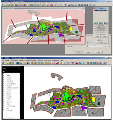
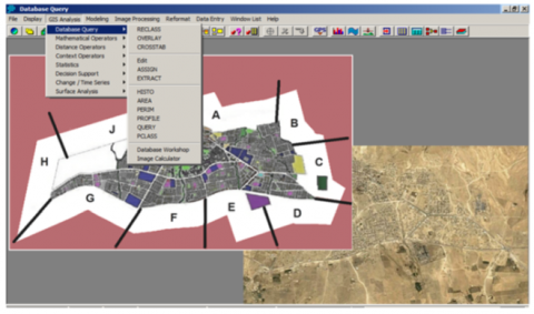
Geographic Information System (GIS) provides planners powerful tools to make better decisions through query and visualization of geographic information. During the past two decades, many GIS programs have been developed as ArcGIS, QGIS, GRASS, and Idrisi. In this study, Idrisi software as a GIS technique was used in analyzing data and interpreting results.
Idrisi is one of the most important programs in the field of GIS. It is distinguished from other programs in that its user does not take much time to learn and practice, and it relies more on dealing with Raster-based GIS cells instead of dealing with vector-based, which makes it suitable to accomplish many of the needs of urban planning designers. It provides the capability to use location as the key variable. The system's multiple layers that are based on computational methods, allow the user to create, store and edit spatial and attribute data, analyze information output, and visualize the results of these operations by presenting them as maps or reports. In this environment, GIS uses various mathematical and logical operations within layers and across layers to derive meaningful conclusions and prepare maps according to the concerned needs.
Weighting layers is a significant step in GIS analysis because it allows the user to define levels of importance that vary on different factors. Since the main objective of this research is to define the potential areas of the future expansion of the city of Sinjar, so, the study used GIS concepts and covers urban, agricultural and conservational land-uses, and defining framework in such a way that can support the decision-making process. The urban area of Sinjar city, whose periphery was set by the 1997 Master plan, is surrounded by areas of land that are available for urban expansion, especially residential expansion, and can be extended over for the next three decades. This part addresses the planning indicators, geological factors, topographical patterns, and different land uses (residential, industrial, forestry, green areas, etc.) that affect the proper decision-making towards directions for potential expansion, of urban expansion in general, down to the town periphery in the target year 2040 for the new Sinjar master plan. Next to gathering information about the status of areas around the town and identifying their needs, criteria are formulated for the classification of these indicators to realize if those areas are well adapted for types of land uses and to identify pros and cons.
3.2 Sinjar city: An overview
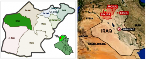
Sinjar city is the administrative center of the Sinjar region of the Nineveh (Mosul) province in Iraq. It is located at the foot of a mountain known by its name (Sinjar Mount), which is characterized by its undulating land and difficult paths. Sinjar is a historic city with a lifetime of more than six thousand years. It is the largest city in the Sinjar District. Kairouan and Sinouni are two towns that are administratively linked to Sinjar (Figure 1).
Figure 1. Sinjar official district & Sinjar city in Nineveh (Mosul) province – Iraq
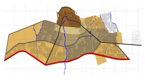
Figure 2. The last master plan of Sinjar - 2007
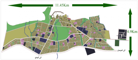
Figure 3. Approximate dimensions-vertical & horizontal-for Sinjar urban spot
Sinjar city is located about 120 km in the north-western far from Mosul, the centre of the Nineveh province at the intersection of longitude 41.52 east and latitude 36.19 north. It currently covers an area of 56,176 km2 and has a population of 88,023 [25]. Its historical depth is represented by the remains of the ancient walls such as the Roman Wall and the Serai - the old traditional city on its northern side. Its extension today grows outside the old city center towards the plane lands on the edge of the mountain, which makes it a capable city for growth and expansion, in the manner of slow expansion and spread of residential neighborhoods in two directions, southeast, and southwest, away from the mountain. Kahreez Great Valley (stream of water descending from the mountain) divides the city into two sides, east and west, with the presence of small kahareez throughout the city. The last Sinjar master plan was officially approved in 2007 (Figures 2, and 3).
3.3 Morphological development of Sinjar city
During the past decades, there have been four phases for the development of the Sinjar urban area: the first phase in the 1940s and 1950s, the second phase in the 1960s and 1970s, the third phase in the 1980s, the fourth phase in the 1990s and the last is the first decade of the new millennium Figure 4.
Figure 4. Morphological development of Sinjar city
3.4 Data and material used
The dataset used in this study was based on the following sources:
3.5 Areas of expansion around the existing Sinjar
Figure 5. Potential expansion zones around the current city of Sinjar 2040
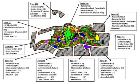
The surrounding areas of Sinjar city are potential lands for urban expansion. To analyze their particular possibilities and constraints, they have been divided into ten homogeneous regions. All are along and adjacent to the current urban spot, except area No.10-Zone T, which lies outside the city, to the north on the external road leading to Sinouni Town, and to the top of Sinjar Mountain. These regions are divided into areas ranging from 75 hectares to 125 hectares. All of these areas are not expected to be annexed to the city, but only the total area required will be combined according to the criteria, which will be distributed among some of the chosen zones according to their convenience land use (residential, commercial, industrial, and so on). Thus, some areas are elected, and others are excluded in compliance with city requirements, with the expansion trends on possible axes, and appropriateness with the land-use factor (Figure 5).
3.6 The expansion zones
Zone A: This area (about 50 hectares) is located to the north of Sinjar urban spot, next to (the Sarai region) and its three neighborhoods (the Sarai, the Burj, and Kalahi) in a striped shape extending east until it overlaps with the archaeological Roman Wall region. It is characterized by being currently the highest area of the city in terms of contour lines for the ascending levels towards Sinjar Mount. Thus, the land is distinguished by severe roughness in its elevations and slopes, causing a high economic cost for urban development (generally, the land in the city tends to decline to south and east). This area overlooks the central region that is the most important area in Sinjar (the old city and the central commercial district of Sarai, extending to the historic Roman wall to the east). It contains the shrine of SayyidaZainabwhich is one of the main city religious sites. Therefore, it represents a district with high historic, heritage, and cultural value.
Zone B: It is located northeast of Sinjar (about 75 hectares). It descends from the mountain edges to the south as flat land, with some slight terrain at its northern side. A small Kahreez aligns it on its western side, forming a natural buffer with the adjacent Nowruz neighborhood. It is a region capable of growth and development, especially for residential and other suitable uses.
Zone C: An area of about 80 hectares east of Sinjar, bordered by Zone B in the north, and Al-Qaraj neighborhood No.2 in the west, and the south by Express Way 47, which connects Sinjar with the most important contiguous settlements, districts, and towns. The area is a plain terrain, and it is a clear extension of its west districts, such as Nowruz and Al-Qaraj. In the Master plan of the years 1997-2007, 22 hectares for an industrial zone have been designated in it, without any implementation until today. The area is an extension of a secondary axis branched from the main axis that arrives from the city center on the eastern city side.
Zone D: It is about 100 hectares located at the eastern entrance of Sinjar city and southeast of Sinjar urban spot, bordered by Highway 47at the north, and penetrated by a branching road from Highway 47 at the south, heading towards the center of Kairouan Town. On the western side, it is bordered by the Building of Sinjar Silo and Zone E. This region contains several shops for construction materials trading and marketing. It is generally a flat area bordered by a small Kahreez from the west and separate it from the adjacent area.
Zone E: it is about 100 hectares located in a central location from the Sinjar southern side, bordered to the north by Road 47, to the east by Sinjar Silo building, and Zone-D, to the west by Zone-F. It is a flat plain zone penetrated by a small Kahreez and separated from Area-D by another one. This zone includes the main city electricity power station that feeds Sinjar city and Sinjar Cement Factory at the same time. The electric high voltage line passes through it.
Zone F: It is about 110 flat plain hectares centrally located to the south of Sinjar on Road 47. It is bordered by Zone-E in the east, and by the branching road from Road 47 toward the center of Al-Baaj Town in the west. It is penetrated by the central Kahreez (located in the middle of Sinjar city) which works as a waterway of large torrents and rids central areas from seasonal floods. The electric high voltage line also passes through it.
Zone G: This zone is about 75 hectares located to the southwest of Sinjar. Highway 47 bound it to the north, and the bypass road to the east extends towards Baaj Town center. It is an extension of its former expansion areas to the west. It is flat terrain, and a small Kakreez passes in its eastern part.
Zone H: This zone is about 70 hectares that located at the far western end of the existing Sinjar master plan. It is closer to elongation, most of its parts are flat plain, and the terrain is rocky and hard. It is bordered to the south by Road 47, to the east by Sirkeften, Al-Nasr, and Wiranshar neighborhoods.
Zone J: It is about 60 hectares located northwest of Sinjar, bordered to the east by the Barbarosh neighborhood, to the north by Sinjar Mountain, and to the south by Sirkeften, Al-Nasr neighborhood. It is a rugged terrain area and contour lines, and it tends to decline to the west. Its shape is somewhat stripped.
Zone T: It is about 50 hectares located north of Sinjar, currently outside the boundaries of the municipality, and separated from the city by large areas of cemeteries, which are not predetermined in the current city master plan. It originated mainly on both ends of the road axis of Sinjar to Kirsi and Sununi towns - the road that crosses Sinjar Mountain to the north. This zone has an irregular shape, and most of the facilities currently emerging in it are primarily tourist sporting and entertainment use. This zone is located among the heights of Sinjar Mount in all directions, and outside the borders of Sinjar municipality and its authority. It is expected that it will be included in the new city master plan.
Table 2. Urban factors and indicators approved for differentiation and classification of expansion areas
|
Urban factors and indicators |
Potential zones for urban expansion |
|
Availability of land areas |
Zones (C,D,E,F,G) |
|
Terrain shape & the geological composition of the earth |
Zones (A,H,J,B) |
|
Axes of transport and public movement (secondary & main axes) |
Zones (C,D,E,F,G) |
|
Environment, climate, winds |
All zones |
|
Waterways and Kahareez, green belts |
Zones (D,E,F,G) |
|
Economic costs for urban development |
All zones |
|
Electric Stations &electric high voltage line |
Zones (D,E,F,G) |
|
Pollution |
All zones |
Equal weights have been given for all types of land uses by (X10) except for residential land use as it was given more weight, which is (3X10) because it mainly needs the land resource. It needs a large abundance of urban land, unlike other uses, which need less of the land resource, in a time that a resource such as an abundance of capital will provide it. The land resource may not be important in investment development in other uses, such as industrial, commercial, tourism, recreational, etc., where the resource (capital) that is the key to its development can provide a limited piece of land to set up development. As for housing or agricultural development, the matter is different. Land resources are one of the most important elements of production, without which no housing development can take place, because the land is the key to housing development [26]. Table 2 shows the urban factors and indicators approved for the differentiation and classification of expansion areas. These factors and indicators carry criteria for evaluation: Potentialities & Constrains.
According to the potential areas for residential, governmental, administrative, and commercial expansion, the predominant trends in the city growth are to east and south, away from the rugged terrains of Sinjar mountains, with blocking situation towards the urban spot resulting from the master plan of 2007, especially as Al-Nasr and Waranshar neighborhoods are still in the development stage, and more than 60% of their lands have not been utilized yet. Because residential and urban infill is expected within the next 20 years, an expansion beyond the infill of the master plan- 2007 requires an east and south extension, if the balanced growth of the city is to be preferred around the urban spot central area, which includes Serai region, the central Kahreez area, the square of Historic Sinjar Minaret and the two domes enter.
3.7 Analysis of the prospective expansion zones
Zone A: This zone is limited in size, with a rugged mountainous nature, but it is an extension of areas of high historical, heritage, and cultural value in the city, which is nominated for locating administrative cultural uses, recreational tourism activities, and heritage commercial activities, including tourist hotels due to its rise and its view toward the city.
Zone B: This zone is medium in size, and its northern part lies at the mountain foot, but most of its area falls south to an undulating area, then flat land. Thus, urban development has an acceptable economic cost. It represents an extension of the secondary movement axes of the market area in the present city from its eastern side. Consequently, it is a candidate for the residential extension and for locating commercial, cultural and service uses, as well as recreational tourism use in its northern part.
Zone C: Due to the nature of this zone, urban development has an acceptable economic cost. It represents an urban extension of the eastern side of the city. Because of its medium area and location, it is likely to be a key area for the new expansion, especially the part of residential use, commercial, sporting, service use, and industrial, with the consideration of the recommendation of converting the proposed industrial uses to an extreme easterly direction, because the prevailing winds tend from it to the city outside. As a result, the industrial zone will not be surrounded by residential areas, since locating facilities of pollution produced in a residential milieu is undesirable.
Zone D: This zone is very likely to be classified as one of the new expansion main areas, because of its large area, its flat plain ground, and it is located on the main movement axis at the city eastern entrance, and it is bordered directly from the north by the international Road 47. Its urban development has low economic costs, contains small kahareez, and requires the establishment of green belts on its southern side. The electric high voltage line passes in its middle.
Zone E: This zone is also subject to urban development, and is likely to become one of the main expansion areas, because of its large area, its flat plain ground - especially for residential, commercial and service uses - its central location, and its site on the road 47 directly and on the city main movement axis at its eastern entrance. Its urban development has low economic costs, contains small kahareez, and requires the establishment of green belts on its southern side. The electric high voltage line passes in its middle. Generally, the two zones D and E are options for locating a new sector center for the city in them, which are suitable for residential expansion with most other land uses (commercial, cultural, administrative, sports, and green belts). Zone D is marked by the possibility of locating a major part of industrial use, particularly in its eastern part.
Zone F and Zone G: These two zones are essential for urban development due to their large area, their flat plainly, and urban development has low economic costs. They are located south of the city, bordered by the international Road 47 from the north. Each of the two zones represents an extension of a major movement axis sloping from the city center from the city's west side. They require establishing green belts on their southern side. An electric high voltage line passes through them. Zone F represents a natural extension of the main valley that divides the city into two sides. Such a zone is a good alternative to locate parks and recreation uses, besides locating a sector center or establishing a civic administrative and commercial center because of its central location. It is also an option for residential expansion with other land uses, such as administrative, cultural, and sports activities. Zone G is a potential for a part of the residential, commercial, administrative, cultural, and service extension, and for a major part of the industrial activity, particularly in its western side.
Zone H: It is located in the farthest area to the city's western side. It has medium size; its land is rocky and rugged. Therefore, it is very expensive for urban development, it is somewhat far from the main city movement axes, and it needs green belts on its western side. It is located on Sinjar Mount foot, facing natural solar radiation. Thus, it is an opportunity to locate a power plant station for solar cells. This zone is generally a preference for service and industrial uses.
Zone J: This zone is located in a rugged and high mountainous area north of the city, then, urban development was economically costly. It has a medium area, and the historical Roman wall is placed on its eastern side. It is located on a secondary axis, branched from the city center to the west. This zone is potential for tourism, entertainment, cultural, and administrative uses due to its view of the city. It is very limited for the ability to locate residential use. It can be considered as a tourist and cultural extension parallel to Zone A.
Zone T: Its area is small and separate from the city's major urban area. If it will be included in the future city master plan, it is an option to turn into a recreational sporting tourist center that serves all the city sectors and its surroundings. Nevertheless, it is certainly not an accurate decision to be a basic expansion area, especially for residential use. The current buildings and uses are tourism, entertainment, and sporting use due to its fine microclimate and distinct site in the valley on the path of the external road crossing Sinjar Mount. The zone is a choice for the continued locating of tourist, recreational, and sporting uses, in addition to its limited commercial and service uses (Figure 6).
Figure 6. Analysis of the prospective expansion zones
Results of the analysis, indicators of expansion characteristics, and appropriate land uses are demonstrated in Tables 3 and 4. Table 3 illustrates the results of the comparison between the potential expansion areas of Sinjar according to the diversity of land uses with convenience and capacity.
Table 3. The results of the comparison between the potential expansion areas of Sinjar according to the diversity of land uses with convenience and capacity
|
Land uses |
Residential |
Commercial |
Administration & cultural |
Service centres |
Industrial |
Recreational & tourism |
Sport canters & clubs |
Green belts |
|
Zone A |
|
± |
± |
|
|
+ |
|
|
|
Zone B |
- |
- |
± |
+ |
|
± |
|
|
|
Zone C |
+ |
± |
|
- |
+ |
|
- |
|
|
Zone D |
+ |
± |
± |
+ |
+ |
|
- |
± |
|
Zone E |
+ |
+ |
+ |
+ |
|
± |
- |
± |
|
Zone F |
+ |
+ |
+ |
+ |
|
± |
- |
+ |
|
Zone G |
+ |
- |
± |
± |
- |
|
|
+ |
|
Zone H |
|
|
|
+ |
± |
|
|
+ |
|
Zone J |
- |
|
± |
|
|
+ |
|
- |
|
Zone T |
|
- |
|
- |
|
+ |
+ |
|
Conscience with full capacity: +, Conscience with half capacity: ±
Conscience with full capacity: -
Table 4. The results of the compatibility between the potential expansion areas of Sinjar according to weights for the convenience and capacity of each land use
|
Land uses |
Residential |
Commercial |
Administration & cultural |
Service centres |
Industrial |
Recreational & tourism |
Sport canters & clubs |
Green belts |
Zone score |
|
Weights |
3*X 10 |
X 10 |
X 10 |
X 10 |
X 10 |
X 10 |
X 10 |
X 10 |
X 100 |
|
Zone A |
0 |
0 |
5 |
0 |
0 |
10 |
0 |
0 |
15 |
|
Zone B |
10 |
3 |
5 |
5 |
0 |
5 |
0 |
0 |
48 |
|
Zone C |
10 |
5 |
0 |
5 |
10 |
0 |
3 |
0 |
53 |
|
Zone D |
10 |
5 |
7 |
10 |
10 |
0 |
3 |
5 |
70 |
|
Zone E |
10 |
10 |
10 |
10 |
0 |
7 |
3 |
5 |
75 |
|
Zone F |
10 |
10 |
10 |
10 |
0 |
7 |
3 |
10 |
80 |
|
Zone G |
10 |
5 |
5 |
5 |
3 |
0 |
0 |
10 |
58 |
|
Zone H |
0 |
0 |
0 |
10 |
5 |
0 |
0 |
10 |
25 |
|
Zone J |
3 |
0 |
5 |
0 |
0 |
10 |
0 |
3 |
27 |
|
Zone T |
0 |
3 |
0 |
3 |
0 |
10 |
10 |
0 |
26 |
Figure 7. The distribution of suitable land uses and their weights over expansion zones
Table 4 illustrates the results of the compatibility between the potential expansion areas of Sinjar according to weights for the convenience and capacity of each land use. As a result of what zone of the expansion zones were obtained from the total scores, a first group with the highest grades can be distinguished between (X15-X100). A second group got grades between (X0 –X50). The first group includes the zones F, D, G, E, and C, which got the weights X80, X70, X58, X57, and X53 respectively. These zones are basic zones in urban development because of their large area and central location. The second group includes zones B, J, H, T, and A which got the weights X48, X27, X25, X16, and X15 respectively. These zones are secondary and non-basic zones, and adequate for specific uses, due to their limited area and their peripheral or lateral location from Sinjar urban spot (Table 4).
Figure 7 shows in detail the distribution of suitable land uses and their weights over expansion zones. According to analysis results, detailed decisions include: Transferring the international road 47 to another route outside and the south of the expansion areas. Shifting the electric high voltage line outside the southern expansion zones to a path parallel to the green belt track that borders the mentioned expansion zones from the south. Proposing to locate the vertical housing in zone F due to its suitability for the sectoral urban center. Locating tall buildings and large hotels in zones A, J, F because of their suitable location for such uses. Moving of construction materials shops from their current location in zone D to be close to the industrial area in the zone east part.
The analysis results of urban indicators that suggest the land use of each of the expansion alternative zones around Sinjar city should be taken into account with a high degree of importance in formulating planning alternatives or scenarios for the future master plan and in taking detailed design decisions related to it. Sustainability principles should govern the process of human, urban and economic development in general, including housing development. The balance of urban development between the city's two sides should be considered, and the causes of imbalance if any must be tracked. Sinjar is a model for the intermediate cities, which is heading for urban expansion.
GIS and On-site analysis of Sinjar's probable expansion areas took into consideration most of their potentials and constraints, making it a suitable example in urban expansion of other similar cities. One of the main results of the expansion of Sinjar City is its urban concentration withdrawal from other overcrowded cities in its region, e.g. Mosul city and Tal Afar city, since the crucial function of the expansion of an intermediate city is “Decentralization", via dispersal and distribution of population concentration away from other crowded cities. The analysis of the potential expansion areas in Sinjar has revealed the existence of two types of regions:
The first type is “basic expansion zones”, which are alternatives for locating city centers and sectoral centers, with achieving the need for residential use. The second type is the “non-basic expansion zones”, which are distinguished as clear specific areas for other important land uses, leading to the integration between the two types in land use distribution in various parts of the city in a comprehensive and balanced manner. As a suggestion, the study of its future expansion utilizing GIS software must be based on the principles of sustainable urban development according to long-term planning of 20 years. By the current research, the ability of the Idrisi program to analyze information and accelerate the decision-making process by processing a large amount of information related to the development of a long-term plan for sustainable urban expansion is obvious. Despite this, the program's potential remains limited and needs the urban designer and human thought to develop general concepts and ideas for such complex projects. It also requires developing the capabilities of the program in the future and experimenting with several plug-ins attached to it to reach more interactive and integrated results.
[1] The CIMES. (1999). Intermediate Cities and World Urbanization. http://www.ceut.udl.cat/en/ciutats-mitjanes-i-intermedies/publicacions/, accessed on date.
[2] Habitat, II. (1996). Report of the united nations conference on human settlements. United Nations Conference on Human Settlements (Habitat II), Istanbul, Turkey. “The Habitat Agenda Goals and Principles, Commitments and the Global Plan of Action”, Istanbul: UN-Habitat. http://unhabitat.org/wp-content/uploads/2014/07/ The-Habitat-Agenda-Goals-and-Principles-Commitments-and-the-Global-Plan-of-Action-2003.pdf, accessed on December 10, 2021.
[3] World Urbanization Prospects. (2019). The 2018 Revision, Department of Economic and Social Affairs. Population Division, United Nations, New York. USA. https://population.un.org/wpp/publications/files/wpp2019_highlights.pdf, accessed on Dec. 10, 2021.
[4] Dematteis, G. (1991). Local nuclear systems and network systems: a geographical contribution to the interpretation of urban dynamics, en BERTUGLIA, C.S. LA BELLA, A. (Ed.), Urban systems. Vol. 1: Theories, the system and the networks, Franco Angeli, Milan.
[5] UIA-CIMES. (1999). The Lleida Declaration on Intermediate Cities and Global Urbanization. Available online: http://www.ceut.udl.cat/en/ciutats-mitjanes-i-intermedies/declaracions/, accessed on June 13, 2021.
[6] El-Gizawy, L., Shawky, M., Fouda, M. (2010). The effect of the urban heritage sites sustainable on the development of intermediate cities: Case study - Mansoura city, Egypt. The 7th International Engineering Conference, Mansoura University, Mansoura, Egypt, 2010.
[7] United, N. (2009). World Urbanization Prospects: The 2009 Revision; Department of Economic and Social Affairs. Population Division: New York, NY, USA.
[8] UN-Habitat. (1996). The Habitat Agenda Goals and Principles, Commitments and the Global Plan of Action. Istanbul: UN Habitat. http://unhabitat.org/wp-content/uploads/2014/07/.
[9] Sietchiping, R., Kago, J., Zhang, X.Q., Tuts, R., Reid, J. (2014). The role of small and intermediate towns in enhancing urban-rural linkages for sustainable urbanization. Regional Development Dialogue, 35: 48-62.
[10] Schipper, R.P.J., Silvius, A.J. (2018). Characteristics of smart sustainable city development: Implications for project management. Smart Cities, 1(1): 75-97. https://doi.org/10.3390/smartcities1010005
[11] Gilbert, R., Don, S., Herbert, G., Stren, R. (1996). Making Cities Work: Role of Local Authorities in the Urban Environment, Routledge, London. https://doi.org/10.4324/9781315066431
[12] Smit, J., Nasr, J., Ratta, A. (1996). Urban Agriculture: Food, Jobs and Sustainable Cities. New York, USA, 35-37.
[13] Vandevyvere, H., Stremke, S. (2012). Urban planning for a renewable energy future: Methodological challenges and opportunities from a design perspective. Sustainability, 4(6): 1309-1328. https://doi.org/10.3390/su4061309
[14] Al-Allaf, E.H. (2014). Preventive conservation as a procedure for safeguarding mosul built heritage. Diyala Journal of Engineering Sciences, 7(2): 98-129. https://doi.org/10.24237/djes.2014.07207
[15] Milojevic, B. (2018). Integrated urban planning in theory and practice. САВРЕМЕНА ТЕОРИЈА И ПРАКСА У ГРАДИТЕЉСТВУ, 13(1): 323-337. https://doi.org/10.7251/STP1813323M
[16] Smith, A.M. (2019). Sustainable Development. In: Leal Filho W. (eds) Encyclopedia of Sustainability in Higher Education. Springer, Cham.
[17] Sachs, J.D. (2015). The Age of Sustainable Development. New York: Columbia University Press. https://doi.org/10.7312/sach17314
[18] United Nations Millennium Declaration. (2000). General Assembly resolution 55/2 of 8 September 2000, https://www.ohchr.org/EN/ProfessionalInterest/Pages/Millennium.aspx, accessed on January 3, 2022.
[19] Magee, L., Scerri, A., James, P., Thom, J.A., Padgham, L., Hickmott, S., Deng H., Cahill, F. (2013). Reframing social sustainability reporting: Towards an engaged approach. Environment, Development, and Sustainability, 15(1): 225-243. https://doi.org/10.1007/s10668-012-9384-2
[20] Abou Leila, S.M.M., Abdel Razik, W. (2011). Features of sustainable development of coastal Intermediate cities: A case study of the cities of Damietta and Al-Qusair, Egypt. The First International Conference - Municipal Administration and sustainable Urban Development in Arab Cities in Cooperation with the United Nations Human Settlements Program UNHABITAT, May 7-9, Kuwait.
[21] Omran, N.A.M. (2002). Improving community services in the targeted areas in sustainable urban development programs. Arab Regional Conference, Urban Planning Authority, Cairo, Egypt.
[22] Ezirigwe, J. (2017). Human rights and property rights in natural resources development. Journal of Energy & Natural Resources Law, 35(2): 201-213. https://doi.org/10.1080/02646811.2017.1298697
[23] Vargas-Hernández, J.G. (2021). Sustainable Natural Resources Management and Land Planning: The Case of Parque Agroecológico De Zapopan. http://dx.doi.org/10.2139/ssrn.3825668
[24] Sheikh Dora, I.I. (1988). Housing Economics. World of Knowledge Series, The National Council for Culture, Arts and Letters, Issue No. 127, Kuwait. https://whc.unesco.org/archive/2017/whc17-41com-inf2.pdf.
[25] Norwegian Refuge Council. (2018). Rapid Needs Assessment – Sinjar Town, Multi Sector Rapid Needs Assessment of Sinjar Town, NRC Iraq. https://www.humanitarianresponse.info/sites/www.humanitarianresponse.info/files/assessments/nrc_rna_report_sinjar_may18_final.pdf, accessed on Jan. 3, 2022.
[26] Al-Nema, M.J. (2019). An evaluation of residential urban land performance in modern quarters in Mosul City in the view of sustainable development principles. Proceedings of the 5th Scientific Conference at the Institute of Urban and Regional Planning for Postgraduate Studies, University of Baghdad, Baghdad, Iraq.