Qassim Mutar Abad Alkhalidy* | Murtadha Mudhefer Shar Al-Kaabi
© 2022 IIETA. This article is published by IIETA and is licensed under the CC BY 4.0 license (http://creativecommons.org/licenses/by/4.0/).
OPEN ACCESS
The research aims to show the problem of housing as a result of the growing population growth by knowing the amount of housing needed and the housing deficit. The study employed the city of Al-Amarah as a case study and focused on three housing sectors that included 54 residential neighbourhoods, as the city occupies an area of 4854,2 hectares. The study shows the causes of this problem are represented by steady urban growth with a growth rate of 3.4%, which was reflected in the size of families, which amounted to 115,509 families, with a housing density of 24.4 families/ha, living in 72,186 housing units with an occupancy rate of 8. The findings show that another reason is the spread of slums in the city, amounting to 5029 housing units. Finally, the study also shows that as long as the present political and economic difficulties remain unsolved, the urbanisation crisis, which is characterised by unregulated unemployment, underemployment, housing shortages, a lack of social infrastructure, and, of course, poverty, will continue to deteriorate.
urban growth, housing problem, Al-Amarah, slums, GIS
The residential function is one of the main functions of cities, so urban geography views the city as a form of housing, and this function is characterized by high flexibility in movement and expansion, as the residential function grows and expands in response to urban growth, as well as the development of other functions such as industrial, commercial and administrative in the urban space within the city. The problem of housing in the city of Al-Amarah, like the Iraqi cities, is related to the demographic aspects of natural growth, incoming immigration, economic, social and administrative factors, as well as the weakness of the planning and political aspects, which resulted in the emergence of a clear housing deficit in the city that did not meet the needs of the city’s families with sufficient housing units on this one hand, and the inability of most residents with limited incomes to buy housing units on the other hand, and this gave a negative indication of the efficiency of the housing unit by occupying more than one family, with a high occupancy rate of (8) people in the housing unit.
Rodríguez-Pose and Storper [1] argued that the majority of the housing as opportunity approach's claims are fundamentally incorrect, resulting in oversimplified and wrong policy suggestions. Martellozzo et al. [2] underlined the negative consequences of past uncoordinated urban and regional planning in Italy, which often featured adaptive ex-post strategies favouring real estate market returns, rather than avoiding ex-ante the unsustainable threats. Han [3] analysed the effects of relaxing the greenbelt in the Seoul Metropolitan Area of South Korea. Ordinary least squares and generalized least squares regressions were employed to measure the policy’s effect on four sprawl measurement criteria: physical growth containment, land and housing values, community service provision cost, and commuting cost. He et al. [4] used geographical "big data" on point of interest density, degree of urban function mixing, location check-in density, housing prices, and population change to measure the urban vitality of patches of new development that occurred in Chinese cities from 2005 to 2015.
Li et al. [5] found distorted urban-rural relationships and the tendency of villages to decline owing to China's long time urban bias policy. The authors also showed concerns about future rural development, which is less mentioned in the plan. It wants people to move to the country and do things to make the countryside better so that it can work with China's new urbanisation plan.
The importance of the research lies in revealing the real causes of the housing problem through selecting the city of Al-Amarah as a case study and placing them in the hands of those responsible for urban planning policy to address this problem in the future.
Therefore, the current study aims to identify the stages of urban growth in the city of architecture and the factors that contribute to this growth. Also, the study tries to determine the housing problems and the housing deficit that result from urban growth. Finally, propose scientific solutions to address the housing problem.
The structure of the study was divided into three sections, as the first section dealt with the factors of urban growth in the city of Al-Amarah. The second section dealt with the residential reality, which included demographic and housing characteristics, and the third topic focused on the problem of housing in the city of Al-Amarah.
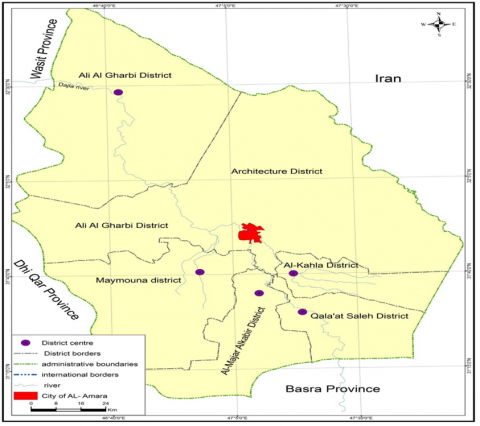
The city of Al-Amarah is located in the centre of the Maysan Governorate in the southeastern part of Iraq, between latitudes of 31.48 and 31.54 in the north and longitudes of 47.6 and 47.13 in the east, as shown in Figure 1. It includes the city located within the main design boundaries of an area of 4854,2 hectares, comprising three sectors of 54 residential neighbourhoods, distributed over 577,543 people, according to population projections for the year 2021, Figure 2.
As for the time limits, it included a study of the reality of urban population growth in the city of Al-Amarah for the period 1947-2021.
Figure 1. The location of the city of Al-Amarah from Maysan Governorate for the year 2021
Figure 2. The basic design map of Al-Amarah city for the year 2007
The rapid expansion of the city under consideration has made the management of growth a central issue in discussions on its development. The paper examines the evolution of urban management in Al-Amarah with the aim of assessing impact on physical development patterns and also identifying the forces that have shaped the evolving state of urban management in the city. The study relied on the descriptive approach and the analytical and statistical approaches in line with the objectives of the research, depending on the population census, the number of housing units, and the basic design map of the city of architecture. The study depended on the use of statistical methods to extract the annual growth rates of the population and their density, which determined the city’s needs for housing units. GIS technology was also used (GIS) to manage data and transform it into cartographic forms based on the data related to it.
4.1 Factors of urban growth in the city of architecture
Emphasis is placed here on demographics, migration, economic, political, and planning factors.
There is a close connection between population growth on the one hand and planning and development approaches on the other, as the population is the main starting point in planning [6], and the goal of development in its various dimensions leads to continuous population growth and more pressure on urban land uses. The population is increasing with the increase in economic activity [7].
4.1.1 Population size in the city of Al-Amarah for the period 1947- 2021
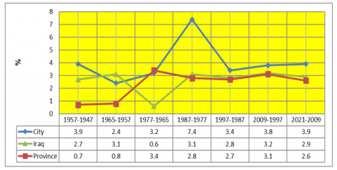
Population size means the number of people who have been counted in a particular area and at a specific time. The study of population size derives its importance from providing a database on which urban studies are based, as well as being a basic indicator to know the needs of the city’s population for all services. There is a direct relationship between population size and the urban expansion of the city [8]. From the analysis of the data in Table 1 and Figure 3, it appears that there is a continuous increase in the population size of the city of Al-Amarah. If compared with the annual growth rates of Maysan and Iraq during the census period (1947–1957), the population of Al-Amarah reached (36501) people in 1957 and rose to (53529) people in 1957, an absolute increase of (17028) people and a growth rate of 3.9%, which is higher than the governorate's (0.7%) and Iraq's (2.7%) growth rates. The reason for the increase in this rate is the increase in the number of births and the factor of migration to the city, as the city is a factor attracting residents from the neighboring rural areas in order to search for a better life within the urban center.
During the census period (1957-1955), it noted an increase in the city’s population to reach 64,714 people in 1965, an increase of (11145) people compared to 1957, and an annual growth rate of 2.4%), which is higher than the growth rate in the governorate of 0.8%, while the annual growth rate in Iraq increased during the same period, reaching 3.1%. Public services in the city and the low level of per capita income due to the lack of job opportunities compared to the cities that the immigrants went to, which enjoy some of the best standards of living for the availability of job opportunities and attention to service aspects in these governorates.
During the period (1965-1977), the city’s population reached 95,111 people, and the amount of population increased was 30,437 people, with an annual growth rate of 3.2%, which is somewhat similar to the population growth in the governorate of (3.4%) and higher than the annual growth rate in Iraq for the same period, which was recorded at (0.6%).
During the period (1977-1987), the city’s population reached (195014) people, with an increase of 99,903 people, and an annual growth rate of 7.4%, more than double what it was during the period (1965-1977) and much higher than that of the period (1965-1977). The annual growth rate of the governorate is 2.8%) and Iraq's is 3.1%.
The growth rates during this period were due to the economic recovery resulting from the increase in oil revenues following the nationalisation of oil in 1972, which was positively reflected in the increase in the population in the city due to the increase in childbearing as well as incoming immigration from the residents of the districts of Al-Uzair, Al-Qal’a, Al-Kahla, and the border areas to the city of Al-Amarah during the Iran-Iraq war.
Figure 3. Annual population growth rate in the city of Al-Amarah compared to Maysan and Iraq for the period (1947-2021)
Table 1. Population number and growth in the city of Al-Amarah compared to Maysan and Iraq for the period (1947-2021)
|
Census year |
City population |
% Annual growth rate |
||||
|
first census |
Second census |
Population increases |
City |
Governorate |
Iraq |
|
|
1947-1957 |
36501 |
53529 |
17028 |
3,9 |
0,7 |
2,7 |
|
1957-1965 |
53529 |
64674 |
11145 |
2,4 |
0,8 |
3,1 |
|
1965-1977 |
64674 |
95111 |
30437 |
3,2 |
3,4 |
0,6 |
|
1977-1987 |
95111 |
195014 |
99903 |
7,4 |
2,8 |
3,1 |
|
1987-1997 |
195014 |
272286 |
77272 |
3,4 |
2,7 |
2,8 |
|
1997-2009 |
272286 |
428804 |
156518 |
3,8 |
3,1 |
3,2 |
|
2009-2021 |
428804 |
577543 |
114723 |
3,9 |
2,6 |
2,9 |
During the period (1987-1997), the city’s population reached 272,286, with an increase of 77,272 people, and the annual growth rate of the city was recorded at 3.4%, which is lower than the annual growth rate of the city for the year 1987. This is due to important factors, including the return of the immigrants to their areas of residence and those who settled in the city of Al-Amarah during the Iran-Iraq war. In addition, the low standards of living were a result of the economic blockade that forced many to return to their rural settlements in the nineties of the twentieth century.
As for the period (1997-2009), it is noted that the city of Al-Amarah witnessed great leaps in the population, reaching a record of 428804 people, with an absolute increase of 156518 people and an annual growth rate of 3.8%, which is higher than the annual growth rate in Maysan and Iraq (3.1% and 3.2%), respectively.
As for the period (2009-2021), the population increase in the city continued, as the population size of the city, according to population projections, reached 577,543 people in 2021, with an absolute population increase of 14,873 people. The annual growth rate was 3.9%, while the governorate reached the growth rate is 2.6%, while Iraq recorded an annual growth rate of 2.9%. The continuous increase in the population size of the study area certainly generates great pressure on the housing units and reduces their functional efficiency, as well as the housing deficit and the emergence of residential slums.
4.1.2 Population migration
Migration gives a dangerous indication of the increase in the housing deficit of cities, including the city of Al-Amarah. Migration, according to the definition of the United Nations, is the movement of people from one geographical area to another in which their place of residence changes, even for a limited period.
As for external migration, it means moving from one country to another [9]. Due to the Iran-Iraq war, migration flocked from Basra Governorate to the city of Al-Amarah during the eighties of the twentieth century, as well as the eastern parts of Maysan Governorate. This contributed to the emergence of the neighbourhoods of Jihad, Al-Sadiq, Al-Zahra, Al-Hassan Al-Askari and the new buildings. But after the political change in Iraq in 2003, migration to the study area increased from the governorates of Diyala, Baghdad, and Salah al-Din due to the chaos and lack of security in those governorates on the one hand, and the stability of the security conditions in the city of Amarah on the other hand, which led to the migration of many families and their stability in the city. On the other hand, the return of immigrant families from other countries, especially America, Canada, Australia, and Sweden, amounted to 7,361 families for the period 2003-2007 [10]. During this period, the second neighbourhoods of Al-Baqir and Al-Ghadir and the Al-Hijrah and Al-Muhajireen Residential Complex appeared with 300 housing units.
4.1.3 Economic factors
Productive, administrative, and service economic factors are among the important factors in attracting the population and their stability in the cities. Most of the industrial establishments were concentrated in the city of Al-Amarah, which registered 675 industrial establishments, which made it a centre for attracting the population as a result of the availability of various job opportunities in the field of industry, bringing the number of workers in it to 3,677 for the year 2018.
The state of separation between the Maysan Oil Company and the Basra Oil Company, the discovery of new oil fields in the fields of Al-Amarah and Al-Noor, and the opening of the Maysan oil refinery, as well as the presence of foreign oil companies operating in the city, such as Petrogaina, Cinoc, Kosel, Dietgen, and Anti Oil, as well as the separation of the University of Maysan from the University of Basra after 2003 One of the most important economic factors that attracted residents to the city of Amarah was that it provided many jobs, which amounted to more than 2416 jobs in various fields [11].
4.1.4 The political and planning factor
Political factors play the largest role in increasing or decreasing the number of housing units in cities, so they give a real indication of the housing reality in those cities and the extent of the widening gap between reality and the housing need in those cities.
It is noted that Iraq in general and the study area in particular during the decades of the fifties, sixties, and seventies of the twentieth century, the impact of the increase in oil exports and the establishment of the Reconstruction Council in 1952 [12], which resulted in the adoption of a reconstruction policy represented by the five-year plan.
The main objective of this plan was to establish an economic and industrial base in Iraq, which completed many important projects, one of which is the policy of building housing units throughout the cities of Iraq. The city of Al-Amarah is among them.
In addition, the distribution of residential land into different segments, and it was followed by giving soft loans for the purpose of building housing units, but soon the spectre of wars and crises descended on Iraq. The decade of the eighties witnessed a complete cessation of many housing, industrial, and other projects following the Iraq-Iran war for the period of 1980-1988. The reason for that was the government’s tendency to spend on military rather than civilian spending, which led to an exacerbation of the housing deficit in return for the population increase.
As well as the halting of housing projects for the period 1991-2002 due to the first Gulf War, in which the economic conditions became represented by the economic blockade imposed on Iraq for the mentioned period. After the political change of 2003, it did not find a role for the specialised bodies in dealing with the housing crisis in all cities of Iraq, including Baghdad, which for four decades left a heavy burden on the concerned authorities on the one hand.
On the other hand, the urban housing gap widened between the actual existing housing units and the need for them, which caused a shortage of housing units in all cities in Iraq, amounting to 3.5 million housing units for the year 2014 [13]. It should be noted that there are attempts by the concerned authorities to adopt the policy of establishing residential complexes that appeared after 2003 following the lifting of the economic blockade and the return of the commercial and economic recovery to Iraq due to the increase in Iraqi oil exports and the large financial returns. On the other hand, most of the residential complexes for which the foundation stone was laid have not been completed to this day, no one has inhabited them, and despite allocating the necessary funds for their construction for political and regional considerations, political factors have had serious impacts on the decreasing housing units against the population increase due to the effect of natural increase and immigration, which explains the size of the large gap between government housing and the current housing deficit in the city. As for the planning factor, the Ministry of Planning, through its channels (the Directorate of Urban Planning in the city of Al-Amarah), has adopted the development of basic designs for the city and is giving future dimension to the development of the city, including the establishment of residential neighbourhoods. To achieve the desired goal that was developed for it only, the basic designs became an administrative framework between the concerned institutions without applying his ideas and proposals.
4.2 The residential reality in the city of Al-Amarah
The city of Al-Amarah includes 54 residential neighborhoods. For ease of study, it has been divided into three housing sectors, with a population of 577,543 people, comprising 115,509 families, who live in 72,186 housing units, occupying an area of 4728 hectares for the year 2021 (Table 2).
4.2.1 Population density of Al-Amarah city for the year 2021
Table 3 and Figure 4 show that the population density reached 122 people/hectare for the entire city of Al-Amarah according to its sectors, but there is a discrepancy in the population density for each sector. The reason for the high density of this rise is the small area it occupies compared to the number of its residents. The second place was taken by the western sector, with a density of 131 people per hectare. The reason for this density is the high number of its population compared to other sectors, while the northern sector ranked third in density. The population amounted to 91 people per hectare, and this decrease is attributed to the decrease in its population. The high population density contributes to increasing pressure on housing units in the occupancy rate, in addition to the housing deficit left by this density, which requires providing a greater number of housing units for the population.
4.2.2 Family size and population density (family/ha)
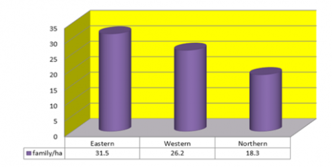
The size of the family is one of the important indicators in urban studies. The larger the family or the multiplicity of families in the housing unit, the more this contributes to increasing pressure on services in general and on the efficiency of the residential function in particular. Table 4 and Figure 5 show that the housing density amounted to 24.4 families/ha for the entire city of Al-Amarah, but there is a discrepancy in the housing density for each sector.
The eastern sector ranked first, with a housing density of 31.5 families/ha. This is due to the small area occupied by this sector compared to other sectors, while the western sector occupies the second place in terms of housing density, which amounted to 26.2 families/hectare due to the expansion of the area of this sector. The northern sector comes in third place with a density of 18.3 families/hectare due to the expansion of the area of this sector in comparison with the areas of other sectors (Figure 6).
Figure 4. Population density (people / hectares) according to the sectors of the city of Al-Amarah for the year 2021
Figure 5. Population density (family / hectare) according to the sectors of the city of Al-Amarah for the year 2021
4.2.3 The size of the housing units
The total housing units in the city of Al-Amarah amounted to 72,186 housing units (Table 5 and Figure 7). Their numbers varied at the level of sectors. The western sector ranked first in terms of the number of housing units, reaching 26,592 housing units, representing 36.8% of the total housing units in the study area. The northern sector’s share ranked second in terms of the number of housing units, which amounted to 23,108 housing units at a rate of 32.0%, with a density of 12.6 housing units/ha, and the third place was for the eastern sector, which included 22,486 housing units, representing 31.2 of the total housing units. Due to the small area occupied by this sector in comparison to other sectors, it ranked first in occupancy density, which amounted to 19.4 housing units/ha.
Table 2. Amara city sectors, population, families, housing and area for the year 2021
|
Sector |
The number of livings |
Population |
Number of families |
Number of dwellings |
Area (hectares) (*) |
|
Eastern |
14 |
182315 |
36463 |
22486 |
1158 |
|
western |
24 |
227580 |
45516 |
26592 |
1737 |
|
North |
16 |
167648 |
33530 |
23108 |
1833 |
|
Total |
54 |
577543 |
115509 |
72186 |
4728 |
(*) Area was calculated using Arc Map10.4 software.
Table 3. Population density (people / hectares) and their percentage according to the sectors of the city of Al-Amarah for the year 2021
|
Sector |
The number of livings |
Percentage % |
Area (hectares) |
Percentage % |
Density (inhabitants/ha) |
|
Eastern |
182315 |
31.6 |
1158 |
24.5 |
157 |
|
western |
227580 |
39.4 |
1737 |
36.7 |
131 |
|
North |
167648 |
29 |
1833 |
38.8 |
91 |
|
Total |
577543 |
100 |
4728 |
100 |
122 |
Table 4. Number of families and their population density (family / hectare) according to the sectors of the city of Al-Amarah for the year 2021
|
Sector |
The number of livings |
Number of families |
Percentage % |
Area (hectares) |
Density (inhabitants/ha) |
|
Eastern |
182315 |
36463 |
31.6 |
1158 |
31.5 |
|
western |
227580 |
45516 |
39.4 |
1737 |
26.2 |
|
North |
167648 |
33530 |
29 |
1833 |
18.3 |
|
Total |
577543 |
115509 |
100 |
4728 |
24.4 |
Figure 6. Residential density (household / hectare) by sectors of the city of Al-Amarah for the year 2021
Table 5. Number of housing units and density of occupancy housing unit/ha in the city of Al-Amarah for the year 2021
|
Sector |
The number of livings |
Percentage % |
Area (hectares) |
(inhabitants/ha) |
|
Eastern |
22486 |
31.2 |
1158 |
19.4 |
|
western |
26592 |
36.8 |
1737 |
15.3 |
|
North |
23108 |
32.0 |
1833 |
12.6 |
|
Total |
72186 |
100 |
4728 |
15.3 |
Figure 7. Occupancy density, housing unit/ha, according to sectors in the city of Al-Amarah for the year 2021
It is noted from Table 6 that the occupancy rate of housing units amounted to 8 people/housing units for the entire city of Al-Amarah, and this rate varied at the level of sectors. Compared with other city sectors, the eastern sector ranked second with an occupancy rate of 8.1 people per housing unit, while the northern sector ranked third with an occupancy rate of 7.3 people per housing unit due to its small population.
Table 6. Average occupancy of residential units, person/house, according to the sectors of the city of Al-Amarah for the year 2021
|
Sector |
Population |
Number of dwellings |
Occupancy rate (person/house) |
|
Eastern |
182315 |
22486 |
8.1 |
|
Western |
227580 |
26592 |
8.6 |
|
North |
167648 |
23108 |
7.3 |
|
Total |
577543 |
72186 |
8.0 |
4.3 Problem of housing in the city of Al-Amarah
4.3.1 Housing shortage
There is demographic pressure in the cities of Iraq in general and the city of Al-Amarah in particular due to the lack of housing units, which leads to a high demand for housing as a result of population increase, migration, and the economic and political factors mentioned above. The housing deficit is defined as the increase in the population (number of families) with shortcomings in the housing balance to cover the increase in the number of families (Stewart, 1980, p88). Table 7 shows the clear housing deficit, which amounted to 43,323 housing units with a deficit rate of -37.51% for the entire city of Al-Amarah, and this deficit varied at the level of the city’s sectors. The eastern sector ranked second in terms of housing deficit, with 13,977 housing units at a rate of (-38.3%), and the northern sector ranked third in terms of housing deficit, with 10,422 housing units at a rate of (-31.1%), owing to the small number of families and population.
4.3.2 Slum dwelling
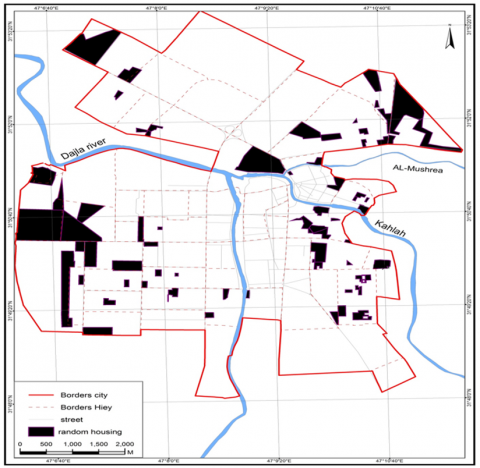
It appears from Table 8 and Figure 8 that the number of random housing units in the city of Al-Amarah reached 5029 housing units with a population of 33,461 people for all sectors of the city [14], but there is a discrepancy in the number of informal housings, as the western sector ranked as the least densely populated in the city. Al- The first acquired slums, which amounted to 1,871 housing units, at a rate of 37.2%, comprising 12,129 people, or 36.2% of the total slum population in the study area. The northern sector ranked last, with 29.8% of slum dwellings, comprising 30.1% of the total slum dwellers.
Table 7. The number of housing units, the number of families and the housing deficit in the city of Al-Amarah by sectors in the city of Al-Amarah 2021
|
Sector |
Population |
Number of families |
Number of dwellings |
Housing Disability (*) |
Deficit percentage (**) |
|
Eastern |
182315 |
36463 |
22486 |
-13977 |
-38,3 |
|
Western |
227580 |
45516 |
26592 |
-18,924 |
-41,6 |
|
North |
167648 |
33530 |
23108 |
-10422 |
-31.1 |
|
Total |
577543 |
115509 |
72186 |
-43323 |
-37,5 |
(*) Housing deficit = number of housing units - number of families
(**) The proportion of the housing deficit = the housing deficit ÷ number of families x 100
Figure 8. Random housing in the city of architecture for the year 2021
Table 8. The number of housing units, the number of families and the housing deficit in the city of Al-Amarah by sectors in the city of Al-Amarah 2021
|
Sector |
Number of slums |
Percentage % |
Population |
Percentage % |
|
Eastern |
1661 |
33.0 |
11264 |
33.7 |
|
Western |
1871 |
37.2 |
12129 |
36.2 |
|
North |
1497 |
29.8 |
10068 |
30.1 |
|
Total |
5029 |
100.0 |
33461 |
100.0 |
From the foregoing, it becomes clear the clear deterioration in the housing sector of the city, especially in the field of building housing units that are not commensurate with the increase in population and the number of families. There will be 48,352 housing units in 2021.
The issue of urban housing cannot be considered in isolation from the country's overall economic and political situation. Commercial and industrial sectors are now functioning quite poorly. The country has suffered from political and economic instability for many years. Thus, the city of Amarah's rapid and uncontrolled urban growth was the primary cause of the housing crisis and deficit, as well as the rise of slums. The data indicate that the city of Al-Amarah saw rapid expansion as a result of natural population growth, as the population expanded from 36,501 in 1947 to 577,543 in 2021.
Additionally, the population of Al-Amarah is unevenly divided between sectors, with 39.4 percent concentrated in the western sector, 31.6 percent in the eastern sector, and 29 percent in the northern sector. On the other hand, housing density varied, reaching 157 people per hectare in the eastern sector and 91 people per hectare in the northern sector, as did family density, which reached 31.5 families per hectare in the eastern sector and 18.3 families per hectare in the eastern sector of the northern sector. Furthermore, as long as the present political and economic difficulties remain unsolved, the urbanisation crisis, which is characterised by unregulated unemployment, underemployment, housing shortages, a lack of social infrastructure, and, of course, poverty, will continue to deteriorate.
[1] Rodríguez-Pose, A., Storper, M. (2020). Housing, urban growth and inequalities: The limits to deregulation and upzoning in reducing economic and spatial inequality. Urban Studies, 57(2): 223-248. https://doi.org/10.1177%2F0042098019859458
[2] Martellozzo, F., Amato, F., Murgante, B., Clarke, K.C. (2018). Modelling the impact of urban growth on agriculture and natural land in Italy to 2030. Applied Geography, 91: 156-167. https://doi.org/10.1016/j.apgeog.2017.12.004
[3] Han, A.T. (2019). Effects of relaxing the urban growth management policy: Greenbelt policy of Seoul metropolitan area, South Korea. Journal of Planning Education and Research, 39(3): 300-314. https://doi.org/10.1177%2F0739456X17739110
[4] He, Q., He, W., Song, Y., Wu, J., Yin, C., Mou, Y. (2018). The impact of urban growth patterns on urban vitality in newly built-up areas based on an association rules analysis using geographical ‘big data’. Land Use Policy, 78: 726-738. https://doi.org/10.1016/j.landusepol.2018.07.020
[5] Li, Y., Jia, L., Wu, W., Yan, J., Liu, Y. (2018). Urbanization for rural sustainability - Rethinking China's urbanization strategy. Journal of Cleaner Production, 178: 580-586. https://doi.org/10.1016/j.jclepro.2017.12.273
[6] Glaeser, E.L., Gyourko, J., Saks, R.E. (2006). Urban growth and housing supply. Journal of economic geography, 6(1): 71-89. https://doi.org/10.1093/jeg/lbi003
[7] As-Salh, M.M., Al-Othman, B.A.A.A. (2020). Some characteristics of the residents of the city of Al-Zubair in 2019. ADAB AL-BASRAH, (92): 479-518.
[8] Belal, A., Shcherbina, E. (2018). Smart-technology in city planning of post-war cities. IOP Conference Series: Materials Science and Engineering, 365(2): 022043. https://doi.org/10.1088/1757-899X/365/2/022043
[9] Scribner, K.T., Blanchong, J.A., Bruggeman, D.J., et al. (2005). Geographical genetics: Conceptual foundations and empirical applications of spatial genetic data in wildlife management. The Journal of Wildlife Management, 69(4): 1434-1453. https://doi.org/10.2193/0022-541X(2005)69[1434:GGCFAE]2.0.CO;2
[10] Bek, M.A., Azmy, N., Elkafrawy, S. (2018). The effect of unplanned growth of urban areas on heat island phenomena. Ain Shams Engineering Journal, 9(4): 3169-3177. https://doi.org/10.1016/j.asej.2017.11.001
[11] Voith, R.P., Wachter, S.M. (2009). Urban growth and housing affordability: The conflict. The Annals of the American academy of Political and Social Science, 626(1): 112-131. https://doi.org/10.1177%2F0002716209344839
[12] Shteiwi, M.E., Zarzoura, F., Jumaah, Z. (2021). A comparative Study of the different remote sensing techniques for evaluating land use/cover in Basra city, Iraq. (Dept. C). MEJ. Mansoura Engineering Journal, 45(4): 21-32. https://dx.doi.org/10.21608/bfemu.2021.139429
[13] Ismael, N.T., Abdulwahab, A.M. (2019). Analysis of land uses in Iraqi cities. Wasit Journal of Engineering Sciences, 7(3): 14-28. https://doi.org/10.31185/ejuow.Vol7.Iss3.134
[14] El-Hadidy, S.M. (2021). The relationship between urban heat islands and geological hazards in Mokattam plateau, Cairo, Egypt. The Egyptian Journal of Remote Sensing and Space Science 24(3): 547-557. https://doi.org/10.1016/j.ejrs.2021.02.004