Josué Briones-Bitar* | Fernando Morante-Carballo | Miguel Á. Chávez-Moncayo | Roberto Blanco-Torrens | Paúl Carrión-Mero
© 2022 IIETA. This article is published by IIETA and is licensed under the CC BY 4.0 license (http://creativecommons.org/licenses/by/4.0/).
OPEN ACCESS
For more than 20 years, problems related to erosive processes and landslides have been detected on Las Cabras hill in Duran, Ecuador. Las Cabras hill has a stability problem due to its sub-vertical slopes (north zone) due to rockfalls, slopes with a favourable slope to landslide (south zone) and two anthropic factors (houses in inappropriate places and a lack of sewer system). From previous studies, Las Cabras has been classified as high to very high susceptibility to landslide (soil) or detachment (rock). Therefore, there is a risk for families living in this area and its surroundings. This study aims to propose engineering solutions through the technical considerations of studies carried out to stabilise the Las Cabras hill and its surroundings. The methodology considers: i) analysis of the results of the engineering studies carried out on the hill, ii) design calculations according to the stability and safety analysis of the slopes employing Hoek and Bray method; and iii) proposal of stabilising solutions in the most susceptible areas of the hill. The solutions have to do with controlling erosive processes and rock masses that can slide or detach. Injected anchors (using gunite and Ø25mm rods) and mechinal drains are proposed to reduce pore pressure in that area. Also, it can be applied in combination with surface channels in the form of a ladder to evacuate rainwater. Ultimately, it is possible to rethink the territorial ordering on Las Cabras hill with these considerations.
landslides, rockfalls, stabilisation, support solutions, bolt, mechanical drains
All those rocks subjected to the action of atmospheric agents suffer a specific degradation that reduces their geomechanical properties. The intrinsic characteristics of each outcrop reflect the tectonic activity of the area and the rocky nature of the place itself [1]. These considerations, along with gravitational and seismic actions, can give rise to a series of instabilities that constitute potential geological hazards when they affect human activities [2]. On slopes, instabilities are due to the geomechanical characteristics of the rocky massif, the state of conservation of the slope itself and the water penetration conditions [3, 4]. The behaviour of a rocky massif generally depends on the characteristics of the discontinuities (stratification, joints, faults, schistosity) that it presents and the lithology of the rocky matrix and its evolutionary history [5].
Landslides are one of the most destructive geological processes that affect people, causing thousands of deaths and property damage each year [6]. However, very few people are aware of its importance. The possibility and frequency of landslides occurrence along any slope depend, in addition, to the geological characteristics of its constituent materials [7].
Generally, a landslide is initiated by a combination of factors such as slope geometry, material strength, structural discontinuity, weathering, and extreme factors (e.g. seismic actions) [8-11]. Tropical mountainous areas are very susceptible to landslide problems because, in addition to the factors mentioned above, they generally meet others such as morphology and extreme rainfall [12].
Precipitation is a significant trigger for slope instability [13-18]. This is evident because most slopes fail during the rainy season [13, 14]. Water along the potential failure surface will reduce shear resistance, facilitating the sliding process [19]. In addition, rocky slopes under seismic load are subject to accelerations that induce slope instability [13]. Slopes that are stable under static conditions can destabilise under seismic load [20, 21]. Another triggering fact in the instability of a slope is the anthropic activities that increase the load and decrease the capacities and geomechanical properties of the rocks. Some of these activities are the construction of highways or other engineering structures or the non-technical use of explosions in quarries or mines [22].
One case or example of the disaster caused by landslides is the one that occurred in the Aberdare Mountain Ranges, Kenya. On April 30, 1997, a landslide buried three houses at the foot of the slope and killed 11 people. The landslide occurred when degraded rocks became saturated after a severe storm on a steep slope that slid over the more stable basalts [23]. A case within Ecuador is in the Olón Cliff, Santa Elena. Here is a tourist attraction such as the Blanca Estrella de Mar Sanctuary, located on a cliff of approximately 40 meters high. Erosion and the low resistance of the rock mass materials have generated instability in a large part of the slope. Blocks of rock were even detached from the cliff, endangering the Sanctuary and the people who visit it at risk [24].
To mitigate these problems, characterisation or engineering studies is very important [25, 26]. For example, a slope or landslide investigation consists of obtaining as much information as possible about the topographic, geological, geotechnical and environmental characteristics that allow the most precise diagnosis of the problems and a practical solution design [27, 28]. In addition, it is necessary to know the basic parameters that affect stability [29].
During the last four decades, numerous authors have carried out studies to evaluate the phenomena of landslides and detachment. As a result, various qualitative, quantitative and empirical approaches have been proposed in the scientific literature to assess hazards and risks arising from landslides, rockfalls or slope instability [30-34]. The choice between qualitative and quantitative hazard methodology is strictly related to the available dataset and does not depend on the complexity of the methods that are used to define the hazard [35].
For more than 20 years, problems related to erosive processes and landslides have been detected on Las Cabras hill in Duran, Ecuador. Several incidents have already been registered due to damage to homes by mudslides, stones, and landslides of weathered and removed rock masses. Las Cabras hill, in different sectors, has different susceptibility degrees to landslides and stability conditions. This is mainly due to the characteristics of the massif present (such as deterioration, fracturing, and layers dipping). Also, it is accentuated by the different anthropic actions (such as informal construction and without territorial planning, and the lack of sewerage), the occurrence of extreme phenomena (heavy rains) and geodynamic phenomena (seismic action).
Due to these problems that occurred on Las Cabras hill, the following question arises: What measures would provide a solution to the stability problem of Las Cabras hill for urban development? That is why this article aims to propose engineering solutions through the technical considerations of studies carried out for the stabilisation of Las Cabras hill and its surroundings.
In this research work, three sections are presented: i) Analysis of previous information (where data from previous studies in the study sector is reviewed), ii) Las Cabras hill stability is evaluated and analyzed (the results of various profiles are compared with national standards, as well as with stability limits proposed in scientific articles), and, iii) Measures are proposed to stabilize Las Cabras hill.
The study area is located in American continent (at southern part), Ecuador country, Guayas province, Duran city (see in Figure 1). The western part of Duran is crossed by the Guayas River, located in front of Santay Island. In its southwestern part, there is a small chain of elevations, among which the most prominent is Las Cabras hill, approximately 88 meters above sea level (m.a.s.l).
Figure 1. Study area location map
Las Cabras hill has an area of 36 hectares and an approximate population of 12,000 people according to the Population and Building Census of Ecuador (INEC, for its acronym in Spanish) [36]. The climate is tropical (sub-humid), with temperatures ranging between 20° and 27°C. According to the National Institute of Meteorology and Hydrology of Ecuador (INAMHI, by its acronym in Spanish) [37], precipitations vary between 800 and 1000 mm/year.
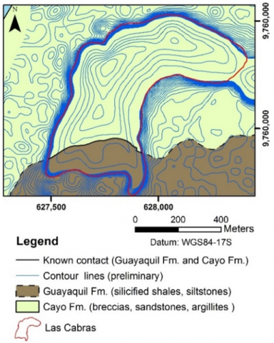
Figure 2. Geological map of the study area [38]
Las Cabras hill is located towards the easternmost part of the Chongón-Colonche Mountain range, which crosses a part of the coastal sector of Ecuador from South-East (SE) to North-East (NE), and which is a division of two important sedimentary basins: to the north the Manabi basin, and the South the Progreso basin. This mountain range is geologically made up of an oceanic basement of toleitic basalts (Piñon Fm.) and sequentially overlay the Calentura Fm., Cayo Fm., Guayaquil Fm. and San Eduardo Fm [39, 40].
The geology of the study area (Figure 2) is represented mainly by Cayo Fm. (Upper Cretaceous) and the Guayaquil Fm. Cayo Fm consists of breccias, microbreccias, sandstones, shales, clays, and argillites. In general, these lithologies alternate and form bodies centimetres to meters thick. The geological structure slopes to the South from 15° to 25° [41]. There has been significant colluvial soil development on top of the base rock, and some soils show signs of the current movement and instability (rotational rupture). Guayaquil Fm. is formed by silicified shales that alternate with brown tobaceous siltstones and sandstones with calcareous cement belonging to the Cayo Fm [42].
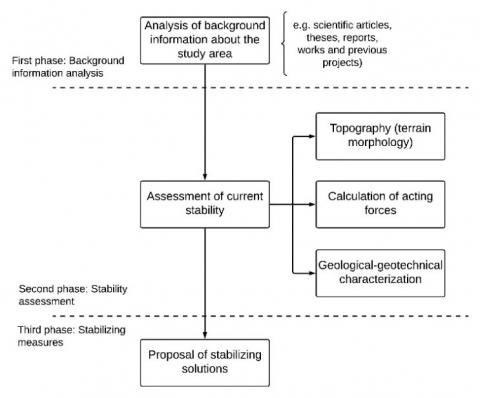
The methodology used in this study (Figure 3) consisted of three phases: i) analysis of background information on the study area; ii) stability analysis of its current state; and iii) proposed stabilising solutions in the most susceptible areas.
Figure 3. Flow diagram of the applied methodology
3.1 First phase: background information analysis
This first phase collected scientific literature related to the study area from various sources (scientific articles, reports, reports, and press releases). The data provided by the project "Studies and proposals for the stabilisation of the" Las Cabras hill" [43] were also collected and in the scientific article" Evaluation of Slope Stability in an Urban Area as a Basis for Territorial Planning: A Case Study" [38]. This review aims to create a database that provides further analysis and the proposal of stabilisation measures.
Since the database is made up of scientific articles and engineering projects, the quality and authenticity of the data in these can be guaranteed. Scientific articles ensure their academic quality due to blind peer review of indexed journals and homogenization of the results [44, 45]. Furthermore, by having reviews from several professionals, engineering projects guarantee the authenticity of the data in various phases of the project.
3.2 Second phase: Stability assessment
In this second phase, the current situation experienced by the study area is put into context. Initially, there is the database generated in the previous phase. Information such as the terrain topography (morphology), geological-geotechnical characteristics, and safety factors calculation are also presented.
3.2.1 Topography and geotechnical characterisation
This phase focused on developing the detailed topography of the Las Cabras hill using S82T GNSS Satellite GPS equipment and a SOKKIA SET 630 total station.
The lithology and stratifications of the terrain are presented through field visits and a database of previous studies [38, 46, 47]. Tectonic fractures are shown, and the identification of fracture families.
3.2.2 Calculation of the safety factor
Authors' different methodologies, such as [20, 30, 34], were reviewed, considering their advantages and application in this case study. For this reason, the method proposed by Hoek and Bray [20] was used, which, within the stability analysis of flat landslides, is one of the most widely used procedures to demonstrate the effect of water action and seismicity. Calculations were carried out to determine the dimensions and weight of the largest wedges and the forces that generate the sliding and detachment of these blocks.
These stability and instability forces are calculated in three different scenarios (modifying the seismic action and the water level). Once these forces are obtained, the value of the safety factor is calculated. Finally, this safety factor value is analyzed and compared with national standards.
3.3 Third phase: Proposal of stabilising measures
In this last section, with the data collected and the slope analysis, in three different scenarios, we proceed to carry out the most optimal designs for this case and the safety considerations for the construction of this stabilising solution.
These solutions are proposed, in agreement, with the territorial ordering proposed by Machiels et al. [38]. Furthermore, the proposed solutions are technically described, adding a reference figure for better understanding. These technical solutions consider what authors described and analyzed, such as ref. [48-52] in other study cases.
4.1 Technical diagnosis
The most relevant results of the project "Studies and proposals for the stabilisation of the Las Cabras hill [43] and of the scientific article "Evaluation of Slope Stability in an Urban Area as a Basis for Territorial Planning: A Case Study" are presented below [38].
Of the geomechanical rock stations analysed, the values of the weathering degree are in categories II-III, and the GSI values are between 70 and 60. RQD values are between 55% and 70%. The values of the lithostructural group are in categories II-III.
Regarding the evaluation of the susceptibility to landslide and detachment, 22.80% of the total area has low susceptibility, 19.11% medium susceptibility, 48.54% high susceptibility and 9.55% very high susceptibility.
4.2 Topography
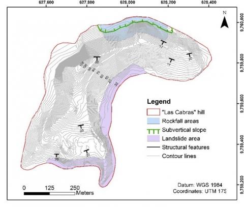
The slopes surrounding Las Cabras hill are vertical and sub-vertical for the most part. These slopes range from 50° to 88°, between 50m and 90m (even more). In the initial level (at the foot of the hill) between 30 to 40, the slope is smoother (from 10° to 30°). In Figure 4, the topography carried out in the study sector is observed.
Figure 4. Topography, structural features and affectations by sectors in the study area [38]
4.3 Geotechnical characterisation
Geological studies previously carried out by Carrión-Mero, 2021 [38] determine an internal geological structure in a stratified pack of silicified shales and siltstones, with certain levels of chert. These have a dip of 15° to 18° to the South and an East-West direction.
A geotechnical characteristic of significant incidence is the intense weathering in the superficial strata (up to 2.50 m deep). This causes these layers to have low shear resistance at the stratification joints. In geotechnical tests carried out, it is established that they have a volumetric weight of 18.50 to 19.50 KN/m3. Also, the peak internal friction angle is 25° to 28°, the residual friction angle is 23° to 26°, and cohesion is 3 to 10 KPa.
At a depth of more than 2.50 m, the layering joints have a higher shear resistance (Shear strength indicates erosion resistance. It is also defined as the resistance to deformation due to the action of efforts [53]). This is verified by an increase in the friction angle up to 15% and an increase in cohesion up to 30%. These indicated values may vary, being reduced by the effect of deterioration caused by direct exposure to the environment.
Another characteristic of great importance in stability analyses is the presence of tectonic fractures. These fractures cut the strata and separate the rock packages or volumes, allowing the infiltration of water, its flow, and hydrostatic thrust generation. Fractures have a certain cementing under natural conditions but can be lost with the erosive action of water. In these cases, the fractures are cleaned and therefore lack cohesion and roughness (they become smooth). The friction angle in these clean fractures has been determined to vary between 28° and 30°. The tectonic fractures expressed in dip and dip direction are F1 300°/70°, F2 60°/60°.
The position of the water table varies remarkably in dry seasons; it is practically nil. Whereas in rainy seasons, it can become superficial.
To evaluate seismicity, it is considered that according to NEC-15 [54], seismic accelerations can reach a value of 0.25 g, even though the said value has never been registered (the maximum accelerations registered in the sector have not exceeded the value of 0.15 g). However, in pseudostatic analyzes (analysis that considers the topography and seismic acceleration), according to NEC-15 [54], 60% of the acceleration must be considered. For this reason, for the seismic evaluation, 0.15g was considered.
4.4 Stability analysis
The possibilities of mass movements with the sliding of loose and weathered rocky materials are analysed. The results of the three pseudostatic analyzes (A, B and C) are presented in Table 1. The general data of the slope under analysis are slope height (25m), rock specific gravity (1.90 ton/m3), cohesion (3 ton/m2) and phi (27°).
Table 1. Determination of the Analysis A safety factor
|
Geometric data |
Geomechanical and seismic data |
||
|
Slope height (m) |
25.00 |
Rock specific gravity (ton/m3) |
1.90 |
|
Water specific gravity (ton/m3) |
1.00 |
||
|
Cohesion (ton/m2) |
3.00 |
||
|
Average slope steepness (o) |
52.00 |
Phi (o) |
27.00 |
|
Seismic acceleration |
0.00 |
||
|
Angle of rupture |
16.00 |
||
|
Calculating: Z, A, W, U, V |
|||
|
Crack height (Z) (m) |
13.17 |
||
|
Total sliding surface (A) (m2) |
42.93 |
||
|
Total sliding surface treated (m2) |
17.60 |
||
|
Rock body weight (W) (ton) |
1 032.38 |
||
|
Water in crack (m) |
10.00 |
||
|
Hydrostatic pressure in base (U) (ton/m2) |
214.65 |
||
|
Lateral hydrostatic pressure (V) (ton/m2) |
50.00 |
||
|
Slope stability degree |
|||
|
Stabilizing forces (ton/m) |
518 043 |
||
|
Destabilizing forces (ton/m) |
332 625 |
||
|
Safety factor (SF) |
1.56 |
||
Analysis A is a landslide without considering seismic action (Static analysis) and a 10m water Table 1. The stabilization forces were 518 043 ton/m, and the destabilization forces were 332 625 ton/m. Therefore, the safety factor (SF) was 1.56.
Analysis B is a landslide considering a seismic action of 0.15g and a 10m water Table 2. The stabilization forces were 496 295 ton/m, and the destabilization forces were 481 483 ton/m. Therefore, the safety factor (SF) was 1.03.
Analysis C is a landslide considering a seismic action of 0.15g and an 11m water Table 3. The stabilization forces were 483 883 ton/m, and the destabilization forces were 491 576 ton/m. Therefore, the safety factor (SF) was 0.98.
Table 2. Determination of the analysis B safety factor
|
Geometric data |
Geomechanical and seismic data |
||
|
Slope height (m) |
25.00 |
Rock specific gravity (ton/m3) |
1.90 |
|
Water specific gravity (ton/m3) |
1.00 |
||
|
Cohesion (ton/m2) |
3.00 |
||
|
Average slope steepness (o) |
52.00 |
Phi (o) |
27.00 |
|
Seismic acceleration |
0.15 |
||
|
Angle of rupture |
16.00 |
||
|
Calculating: Z, A, W, U, V |
|||
|
Crack height (Z) (m) |
13.17 |
||
|
Total sliding surface (A) (m2) |
42.93 |
||
|
Total sliding surface treated (m2) |
17.60 |
||
|
Rock body weight (W) (ton) |
1 032.38 |
||
|
Water in crack (m) |
10.00 |
||
|
Hydrostatic pressure in base (U) (ton/m2) |
214.65 |
||
|
Lateral hydrostatic pressure (V) (ton/m2) |
50.00 |
||
|
Slope stability degree |
|||
|
Stabilizing forces (ton/m) |
496 295 |
||
|
Destabilizing forces (ton/m) |
481 483 |
||
|
Safety factor (SF) |
1.03 |
||
Table 3. Determination of the analysis C safety factor
|
Geometric data |
Geomechanical and seismic data |
||
|
Slope height (m) |
25.00 |
Rock specific gravity (ton/m3) |
1.90 |
|
Water specific gravity (ton/m3) |
1.00 |
||
|
Cohesion (ton/m2) |
3.00 |
||
|
Average slope steepness (o) |
52.00 |
Phi (o) |
27.00 |
|
Seismic acceleration |
0.15 |
||
|
Angle of rupture |
16.00 |
||
|
Calculating: Z, A, W, U, V |
|||
|
Crack height (Z) (m) |
13.17 |
||
|
Total sliding surface (A) (m2) |
42.93 |
||
|
Total sliding surface treated (m2) |
17.60 |
||
|
Rock body weight (W) (ton) |
1 032.38 |
||
|
Water in crack (m) |
11.00 |
||
|
Hydrostatic pressure in base (U) (ton/m2) |
236.11 |
||
|
Lateral hydrostatic pressure (V) (ton/m2) |
60.50 |
||
|
Slope stability degree |
|||
|
Stabilizing forces (ton/m) |
483 883 |
||
|
Destabilizing forces (ton/m) |
491 576 |
||
|
Safety factor (SF) |
0.98 |
||
4.5 Stabilizing measures proposals
Figure 5 presents a map of where these stabilisation solutions are proposed.
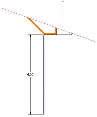
4.5.1 Injected anchor and drainage channel
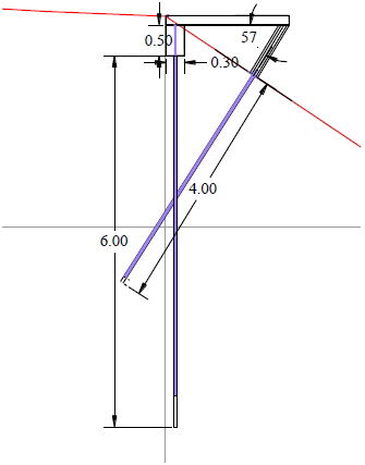
Due to the analysis previously carried out, total control of the water flow must be established. Flows should not accumulate or be discharged on any part of the slopes since they can generate erosion and mass movements. Therefore, building 120 m of a drainage channel with a straight and trapezoidal section is proposed to capture and conduct the rainwater accumulated on the slope. At the base of this channel, 6m long injected anchors should be built, spaced 2m apart. Linked to the channel, an enclosure estimated to be 2.5m high should also be made. The section of the drainage canal can be seen in Figure 6.
Control of subsurface and deep flows is also critical. For example, septic tanks are recommended to be removed. Also, wastewater must be captured and conducted through pipes.
Figure 5. Location, within Las Cabras hill, of the proposed engineering solutions
Figure 6. Drainage channel and proposed injected anchor
4.5.2 Landslide management
It is important to build stabilising solutions that at the same time generate added values. It is proposed to construct a 320 meters long and 0.15 meters thick slab protruding from the edge as a tourist lookout. Two rows of stabilising anchors support it:
(a) The proposed injected anchor systems
(b) Slab support as a tourist lookout
Figure 7. Scheme of the proposed stabilisation system
The anchors' stabilising effect consists of making holes, injecting them under pressure, and placing a steel bar with a diameter of 20 millimetres, which makes up the anchored system. Figures 7a and 7b show the injected anchor system proposed in points (1) and (2).
The lookout slab also aims to construct a gutter canal linked to it. With this, the water from the highest parts can be transported. The collected flow must be conducted through one or two PVC pipes to the lower part, discharge that must be controlled in its erosive power.
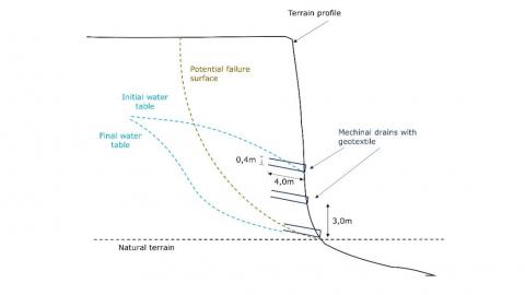
4.5.3 Mechanical drains
It is proposed to build horizontal or filtering drains so that the water table is not so high in the rainy season. With this, the water that infiltrates the Las Cabras hill is controlled. These must be distributed in a "three bolillo" configuration, also considering the location of buildings where this solution cannot be built. There are a total of 123 filter drains, drilled to a maximum depth of 4 m., and accompanied by mechanicals made with geotextile, with the proper fasteners to prevent the filter element from coming out. Filter drains must have a minimum inclination of 10 degrees with the horizontal, and the diameter of the perforations, where the drains will be located, should not be greater than 40 mm.
The cross-sectional arrangement of the filter drains is shown in Figure 8.
Figure 8. Cross-sectional arrangement of filter drains
4.5.4 Retaining wall
Figure 9. The current situation on Las Cabras hill
Many houses have been built at the foot of the slopes, almost vertical, whose height fluctuates between 15 m and 20 m. These houses are less than 10 meters from the vertical slope. Several landslides have occurred in this sector that has affected some homes. The field visits carried out have been fully verified that these slopes are unstable since large blocks of rockfall (Figure 9).
Due to those mentioned above, the first solution should consist of evicting homes closest to the slope foot. If this is not the case, the proposed solution is to construct a wall (dike) of reinforced earth to buffer from 5 meters away from the foot of the slope. It is recommended to place a layer of soil as a buffer in these first 5 meters. Additionally, the reinforced earth dam must be placed in 0.6 m soil and geotextile layers (Figure 10).
Figure 10. Arrangement and placement of the retaining wall
According to the studies carried out by Machiels et al. [38] and Blanco [43], the safety factor within the study area is between 0.76 and 2.20. There are areas on the hill that present safety factors less than one (Table 3). The studies of ref. [54-56] proposed that the slope is considered unstable for safety factors less than one. For this reason, it is necessary to propose and design a solution for stabilisation in the affected sectors. The design proposes the implementation of injected anchors (using gunite and Ø25mm rods) and drainage channels to reduce the water table in certain areas. These proposed solutions guarantee stability against sliding and detachment [24, 28]. These works must start from the top and continue towards the base of the hill slopes to guarantee the stability designed in the entire proposed area of Las Cabras hill (no risk of landslides or detachment). It is not proposed to vacate buildings, except those that are particularly unsafe or are in the proposed stabilisation zones.
The use of bolts has been considered, adding a shotcrete grout, which infiltrates all the discontinuities of the rock massif. In this way, all small or separate blocks are anchored into a single block, somewhat similar to a fissure fill.
Due to the rainfall in the study area, considering the proposed application of the use of injected anchors, it is intended to alleviate the water load using mechanical drains. The option of drains is also supported by the many discontinuities and fractures that the rocky massif has because the infiltrated water causes a hydrostatic thrust to be generated, favouring sliding.
It can be observed in Tables 1-3 that the safety factor decreases drastically with the increase in the water table and seismic action. In the static analysis results (only considering the topography), there is a safety factor greater than 1.80. MIDUVI [54] indicates a condition of stability by having a safety factor greater than 1.50. When adding the water table parameter, the safety factor decreased between 1.60-1.50, which remains stable.
In pseudo-static condition, with a seismic acceleration of 0.15g (Table 2), the safety factor decreased between 1.10-1.03. According to MIDUVI [54], a slope is stable in pseudo-static conditions when the safety factor is greater than 1.05. Finally, considering the rise of one more meter in the water table, the safety factor decreased between 0.99-0.98. Indicating that the slopes are unstable under these conditions. Considering that part of the hill is made up of competent and moderately competent rocks, it is considered that these two factors (seismic acceleration and water table) are the ones that most affect the possibility of landslide or detachment.
Based on numerous experiences [48, 49], it has been found that the combination of gunite with mechanical drains is one of the best solutions to stabilise slopes that, due to their height or geological characteristics, may fail. Shotcrete has a high compressive and shear resistance, important for stability, which is higher than the resistance of the original slope material. Meanwhile, the mechanicals drains to relieve the great hydrostatic pressure on the slope. With this, it can be ensured that the safety factor will increase in the areas where shotcrete and mechanical drains are used [50, 51].
The advantages of constructing the proposed solutions in Las Cabras hill are socio-environmental and economic-cultural. In the socio-environmental part, security and stability are provided to the population and buildings of the hill and surroundings. Furthermore, gunning is a convenient and environmentally friendly slope reinforcement technology [52]. In the economic-cultural part, the Duran Municipality will have the possibility of carrying out a safer territorial ordering since, with the solutions proposed, sustainability in the most critical areas of Las Cabras hill is guaranteed [36].
The case of Las Cabras hill, in Duran, due to its instability situation, where the population settled without territorial planning, creating a social problem, its geodynamic situation has been evaluated and, at the same time, sustainability solutions are proposed for the security of homes and the people who live there. The key factor is to counteract the areas most prone (high and very high susceptibility) to rockfalls, landslides and mass flow. Therefore, a buffer wall (at the slopes foot) and a combination of anchors, tiles, and rainwater gutters are proposed for stability on the south side. While, in the case of the north side, the use of injection anchors and mechanical drains is being considered.
The proposed injected anchors (using gunite and Ø25mm rods) and mechanical drains increase the safety factor, according to the NEC-15, to ensure the stability of the slopes and safety for the people who live there. Furthermore, a combination of surface channels can be applied to evacuate rainwater in specific hill sectors, thereby increasing the safety factor. It is important to design this proposed integral drainage system that guarantees the adequate elimination of all rainwater. Also, it is recommended to remove existing septic tanks. As well as prohibiting new one's construction since these could erode the soil due to the infiltration of residual water. Therefore, it is necessary to design a sewerage plan in the area
After all the considerations and analysis carried out in this research, it can be said that the engineering solutions add value to Las Cabras hill's population. This is due to the geomechanical stability that would be given to the area and the possibility of land use planning and carrying out tourist activities. However, according to susceptibility to landslides or detachment areas, relocating people at risk to more stable areas within the same hill is recommended. Also, the people settled where the support engineering works are planned should be relocated to more stable hill sectors.
This paper proposes engineering solutions (support and stabilization) as the basis or first actions on Las Cabras hill. As future research, the proposal of solutions or works to encourage tourism is encouraged. Sustainability strategies for these works and policies or actions for hill population formation are also recommended. This would have the effect of proactively complementing these solutions and seeking to improve the quality of life of its inhabitants.
This work has been made possible thanks to supporting from ESPOL Polytechnic University. This research was funded by “Registro del Patrimonio Geológico y Minero y su incidencia en la defensa y preservación de la geodiversidad en Ecuador (Registry of Geological and Mining Heritage and its impact on the defense and preservation of geodiversity in Ecuador), CIPAT-01-2018”, and “Studies and proposals for the stabilization of Las Cabras hill”.
[1] González de Vallejo, L., Ferrer, L., Ortuño, L., Oteo, C. (2002). Ingeniería Geológica. Prentice Hall-Pearson Education.
[2] Mira, A., Alcántara, A., Gutiérrez, F. (2013). Geomechanical characterization and analysis of rock mass stability of the south talus of Monteagudo (Murcia, Spain). Geogaceta, 54(1): 151-154. https://doi.org/10.13140/RG.2.1.4669.3522
[3] Cruden, D.M. (1991). A simple definition of a landslide. Bulletin of the International Association of Engineering Geology-Bulletin de l'Association Internationale de Géologie de l'Ingénieur, 43(1): 27-29. https://doi.org/10.1007/BF02590167
[4] Audisio, C., Nigrelli, G., Pasculli, A., Sciarra, N., Turconi, L. (2017). A GIS spatial analysis model for landslide hazard mapping application in alpine area. International Journal of Sustainable Development and Planning, 12(5): 883-893. https://doi.org/10.2495/SDP-V12-N5-883-893
[5] Briones-Bitar, J., Carrión-Mero, P., Montalván-Burbano, N., Morante-Carballo, F. (2020). Rockfall research: A bibliometric analysis and future trends. Geosciences, 10(10): 403. https://doi.org/10.3390/geosciences10100403
[6] Brabb, E., Hrrod, B. (1989). Landslides: Extent and economic significance. 28th International Geological Congress: Symposium on landslides, Netherlands, pp. 385-392.
[7] Rawat, M., Varun, J., Uniyal, D., Rawat, B. (2015). Investigation of hill slope stability and mitigation measures in Sikkim Himalaya. International Journal of Landslide and Environment, 3(1): 8-15.
[8] Souley, M., Homand, F. (1996). Stability of jointed rock masses evaluated by UDEC with an extended Saeb Amadei constitutive law. Int. J. Rock Mech. Min. Sci. Geomech, 33(3): 233-244. https://doi.org/10.1016/0148-9062(95)00063-1
[9] Umrao, R., Singh, R., Ahmad, M., Singh, T. (2011). Stability analysis of cut slopes using continuous slope mass rating and kinematic analysis in Rudraprayag district, Uttarakhand. Geomaterials, 1(3): 79-87. https://doi.org/10.4236/gm.2011.13012
[10] Kainthola, A., Singh, P., Wasnik, A., Sazid, M., Singh, T. (2012). Distinct element modelling of Mahabaleshwar road cut hill slope. Geomaterials, 2(4): 1005-113. https://doi.org/10.4236/gm.2012.24015
[11] Ahmad, M., Ansari, M. and Singh, T. (2013). Instability investigations of basaltic soil slopes along SH-72, Maha0rashtra, India. Nat Hazard Risk, 6(2): 115-130. https://doi.org/ 10.1080/19475705.2013.826740
[12] Suárez, J. (1998). Landslides and slope stability in tropical areas. UIS Editorial. https://www.erosion.com.co/deslizamientos-y-estabilidad-de-taludes-en-zonas-tropicales/.
[13] Ermias, B., Raghuvanshi, T.K., Abebe, B. (2017). Landslide Hazard zonation (LHZ) around Alemketema town, north Showa zone, Central Ethiopia-a GIS based expert evaluation approach. International Journal of Earth Sciences and Engineering, 10(1): 33-44. https://doi.org/10.21276/ijese/2017.10.01.06
[14] Raghuvanshi, T.K., Ibrahim, J., Ayalew, D. (2014). Slope stability susceptibility evaluation parameter (SSEP) rating scheme–an approach for landslide hazard zonation. Journal of African Earth Sciences, 99: 595-612. https://doi.org/10.1016/j.jafrearsci.2014.05.004
[15] Gordo, C., Zêzere, J.L., Marques, R. (2019). Landslide susceptibility assessment at the basin scale for rainfall-and earthquake-triggered shallow slides. Geosciences, 9(6): 268. https://doi.org/10.3390/geosciences9060268
[16] Ayalew, L., Yamagishi, H., Ugawa, N. (2004). Landslide susceptibility mapping using GIS-based weighted linear combination, the case in Tsugawa area of Agano River, Niigata Prefecture, Japan. Landslides, 1(1): 73-81. https://doi.org/10.1007/s10346-003-0006-9
[17] Dai, F.C., Lee, C.F. (2001). Terrain-based mapping of landslide susceptibility using a geographical information system: A case study. Canadian Geotechnical Journal, 38(5): 911-923. https://doi.org/10.1139/t01-021
[18] Collison, A., Wade, S., Griffiths, J., Dehn, M. (2000). Modelling the impact of predicted climate change on landslide frequency and magnitude in SE England. Engineering Geology, 55(3): 205-218. https://doi.org/10.1016/S0013-7952(99)00121-0
[19] Segoni, S., Rosi, A., Rossi, G., Catani, F., Casagli, N. (2014). Analysing the relationship between rainfalls and landslides to define a mosaic of triggering thresholds for regional-scale warning systems. Natural Hazards and Earth System Sciences, 14(9): 2637-2648. https://doi.org/10.5194/nhessd-2-2185-2014
[20] Hoek, E., Bray, J. (1981). Rock Slope Engineering. Institute of Mining and Metallurgy.
[21] Duan, L.S., Xiang, M.S., Yang, J., Wei, X.H., Wang, C.J. (2020). Dynamics and change features of the eco-environment restoration in the worst hit area of a strong earthquake. International Journal of Sustainable Development and Planning, 15(6): 819-825. https://doi.org/10.18280/ijsdp.150604
[22] Shukla, S., Khandelwal, S., Verma, V., Sivakugan, N. (2009). Effect of surcharge on the stability of anchored rock slope with water filled tension crack under seismic loading condition. Geotechnical and Geological Engineering, 27(1): 529-538. https://doi.org/10.1007/s10706-009-9254-3
[23] Ngecu, W., Ichang'i, D. (1999). The environmental impact of landslides on the population living on the eastern footslopes of the Aberdare ranges in Kenya: A case study of Maringa Village landslide. Environmental Geology, 38(3): 259–264. https://doi.org/10.1007/s002540050423
[24] Carrión-Mero, P., Pineda-Ruiz, R., Chávez, M.Á., Morante-Carballo, F., Aguilar, M., Briones-Bitar, J. (2020). Geomechanical evaluation of the Olon cliff for stabilisation pre-design of the Blanca Estrella del Mar Sanctuary, Santa Elena, Ecuador. WIT Transactions on Ecology and the Environment, 241(1): 467-479. https://doi. 10.2495/SDP200381
[25] Carrión Mero, P., Blanco Torrens, R., Borja Bernal, C., Aguilar Aguilar, M., Morante Carballo, F., Briones Bitar, J. (2019). Geomechanical characterisation and analysis of the effects of rock massif in Zaruma city, Ecuador. Proceedings of the LACCEI International Multi-Conference for Engineering, Education and Technology, Jamaica. https://doi.org/10.18687/LACCEI2019.1.1.362
[26] Morante-Carballo, F., Apolo-Masache, B., Carrión-Mero, P., Cedeño, B., Montalvan-Toala, J. (2021). Considerations in the methodology for the technical-environmental viability of sanitary landfills in rural communities. Northern case of the province of Santa Elena, Ecuador. International Journal of Sustainable Development and Planning, 16(2): 317-325. https://doi.org/10.18280/ijsdp.160211
[27] Ramírez, O., Monge, A. (2007). Rock Mechanics: Fundamentals and slope engineering. Universidad Politécnica de Madrid. https://oa.upm.es/14183/.
[28] Morante, F., Aguilar, M., Ramírez, G., Blanco, R., Carrión, P., Briones, J., Berrezueta, E. (2019). Evaluation of slope stability considering the preservation of the general patrimonial cemetery of Guayaquil, Ecuador. Geosciences, 9(3): 103. https://doi.org/10.3390/geosciences9030103
[29] Carrión-Mero, P., Solórzano, J., Chávez, M.Á., Blanco, R., Morante-Carballo, F., Aguilar, M., Briones-Bitar, J. (2020). Evaluation of geomechanical features and stability for the recommendations and rehabilitation of the Humberto Molina Hospital, Zaruma, El Oro, Ecuador. WIT Transactions on Ecology and the Environment, 241(1): 455-466. https://doi.org/10.2495/SDP200371
[30] Barrantes Castillo, G., Barrantes Sotela, O., Núñez Roman, O. (2011). Effectiveness of the modified mora-vahrson methodology in the case of landslides caused by the Cinchona earthquake, Costa Rica. Revista Geográfica de América Central, 42(2): 141-162. https://www.redalyc.org/pdf/4517/451745770006.pdf.
[31] Evans, S.G., Hungr, O. (1993). The assessment of rockfall hazard at the base of talus slopes. Canadian Geotechnical Journal, 30(4): 620-636. https://doi.org/10.1139/t93-054
[32] Crosta, G.B., Agliardi, F. (2003). A methodology for physically based rockfall hazard assessment. Natural Hazards and Earth System Sciences, 3(5): 407-422. https://doi.org/10.5194/nhess-3-407-2003
[33] Peila, D., Guardini, C. (2008). Use of the event tree to assess the risk reduction obtained from rockfall protection devices. Natural Hazards and Earth System Sciences, 8(6): 1441-1450. https://doi.org/10.5194/nhess-8-1441-2008
[34] Macciotta, R., Martin, C.D., Morgenstern, N.R., Cruden, D.M. (2016). Quantitative risk assessment of slope hazards along a section of railway in the Canadian Cordillera—a methodology considering the uncertainty in the results. Landslides, 13(1): 115-127. https://doi.org/10.1007/s10346-014-0551-4
[35] Cascini, L. (2008). Applicability of landslide susceptibility and hazard zoning at different scales. Engineering Geology, 102(3-4): 164-177. https://doi.org/10.1016/j.enggeo.2008.03.016
[36] INEC. Censo poblacional 2020. https://www.ecuadorencifras.gob.ec/institucional/home, accessed on Mar. 29, 2021.
[37] INAMHI. Datos meteorológicos e hidrológicos. www.serviciometeorologico.gob.ec, accessed on Mar. 29, 2021.
[38] Machiels, L., Garces, D., Snellings, R., Vilema, W., Morante, F., Paredes, C., Elsen, J. (2014). Zeolite occurrence and genesis in the Late-Cretaceous Cayo arc of Coastal Ecuador: Evidence for zeolite formation in cooling marine pyroclastic flow deposits. Applied Clay Science, 87: 108-119. https://doi.org/10.1016/j.clay.2013.10.018
[39] Machiels, L., Morante, F., Snellings, R., Calvo, B., Canoira, L., Paredes, C., Elsen, J. (2008). Zeolite mineralogy of the Cayo formation in Guayaquil, Ecuador. Applied Clay Science, 42(1-2): 180-188. https://doi.org/10.1016/j.clay.2008.01.012
[40] Thalmann, H. (1946). Micropaleontology of upper cretaceous and Paleocene in western Ecuador. AAPG Bulletin, 30(3): 337-347. https://doi.org/10.1306/3D933802-16B1-11D7-8645000102C1865D
[41] Benítez, S. (1995). The geodynamic évolution of the coastal Ecuatorian province during the upper Cretaceous-Tertiary. Géology Alp., 71(1). https://tel.archives-ouvertes.fr/tel-00542421/file/These-Benitez-1995.pdf.
[42] Carrión-Mero, P., Briones-Bitar, J., Morante-Carballo, F., Stay, D., Blanco, R., Berrezueta, E. (2021). Evaluation of slope stability in an urban area as a basis for territorial planning: A case study. Applied Sciences, 11(11): 5013. https://doi.org/10.3390/app11115013
[43] Blanco, R. (2015). Studies and proposals for the stabilization of Cerro Las Cabras. Municipalidad de Durán, CIPAT- ESPOL. Unpublished work.
[44] Ramos-Rodríguez, A.R., Ruíz-Navarro, J. (2004). Changes in the intellectual structure of strategic management research: A bibliometric study of the Strategic Management Journal, 1980-2000. Strategic Management Journal, 25(10): 981-1004. https://doi.org/10.1002/smj.397
[45] Milán-García, J., Uribe-Toril, J., Ruiz-Real, J.L., de Pablo Valenciano, J. (2019). Sustainable local development: An overview of the state of knowledge. Resources, 8(1): 31. https://doi.org/10.3390/resources8010031
[46] Núñez del Arco, E. (2004). Geología del Ecuador. Escuela Superior Politécnica del Litoral. https://fdocuments.ec/document/libro-geologia-del-ecuador-por-ing-nunez-del-arco.html.
[47] Altafulla Figueroa, L.E. (2020). Determination of the origin of the rocks of Las Cabras hill (West) through geochemical analysis, Durán canton, Guayas province-Ecuador. Bachelor's thesis, Facultad de Ciencias Naturales, Universidad de Guayaquil. http://repositorio.ug.edu.ec/handle/redug/48647.
[48] Carballo, F.M., Mero, P.C., Chávez, M.Á., Aguilar, M. (2019). Design of the stabilization solutions in the general patrimonial cemetery of Guayaquil, Ecuador. In Proceedings of the 17th LACCEI International Multi-Conference for Engineering, Education and Technology. Jamaica. https://doi.org/10.18687/LACCEI2019.1.1.368
[49] Miguel, C.M. (1980). Contribution to the studies and designs for the construction of a tunnel in cerro del carmen. Sociedad Ecuatoriana de Mecánica de Suelos y Rocas, Guayaquil Ecuador, Unpublished Work.
[50] Su, C., Cheng, Y. (2018). Stability analysis of bolts reinforced rock jointed slope by considering the transverse effects. Soil Mechanics and Foundation Engineering, 55(4), 223-232. https://doi.org/10.1007/s11204-018-9529-x
[51] Brady, B.H., Brown, E.T. (2006). Rock Mechanics: For Underground Mining. Springer Science & Business Media.
[52] Yang, Q., Zhu, X., Luan, M. (2007). Development of hyperbolic model for fully grouting rock bolt and parameters analysis for anchoring effect. Yanshilixue Yu Gongcheng Xuebao/Chinese Journal of Rock Mechanics and Engineering, 26(4), 692-698.
[53] Flerchinger, G.N., Lehrsch, G.A., McCool, D.K. (2013). Freezing and Thawing | Processes. Reference Module in Earth Systems and Environmental Sciences. https://doi.org/10.1016/B978-0-12-409548-9.05173-3
[54] MIDUVI. Capítulos de la NEC (Norma Ecuatoriana de la Construcción). https://www.habitatyvivienda.gob.ec/documentos-normativos-nec-norma-ecuatoriana-de-la-construccion/, accessed on Mar. 29, 2021.
[55] Melentijevic, S. (2005). Slope stability in rock massis with non-linear failure criteria and unassociated yield laws. Doctoral dissertation, Universidad Politécnica de Madrid, Spain. https://oa.upm.es/722/.
[56] Carrión-Mero, P., Aguilar-Aguilar, M., Morante-Carballo, F., et al. (2021). Surface and underground geomechanical characterization of an area affected by instability phenomena in zaruma mining zone (Ecuador). Sustainability, 13(6): 3272. https://doi.org/10.3390/su13063272