Mohannad Tarrad* | Majed Ibrahim
© 2021 IIETA. This article is published by IIETA and is licensed under the CC BY 4.0 license (http://creativecommons.org/licenses/by/4.0/).
OPEN ACCESS
All human societies seek stability and use of place and material in order to create architectural buildings. One of the most important materials that man used as a building material was natural stone, and in Jordan stone has a special architectural value, as Jordanian architects used it to form a unique architectural style, especially in the capital, Amman. But at the end of the last century and the beginning of the current century, alternative manufactured building materials appeared, and architects began using them for many reasons, including the lack of quality of natural stone and its defects, which resulted in deformation of the architectural facades. The research used remote sensing techniques to know the properties and quality of the stone. This research used the descriptive approach in studying the history of architecture in Jordan and its relationship to limestone, and relied on the analytical survey by obtaining data from satellite images, where they were analyzed and the properties of the stone in the ground were shown. This research aims to preserve the use of natural stone in construction as a building material that has characteristics in sustainability.
Jordanian architecture, limestone, remote sensing, stone quarries
In his famous introduction, the Arab thinker and philosopher Ibn Khaldun described the process of the deteriorating of housing in cities. Some of which become undeveloped because of the decrease of their inhabitants due to immigration. The discontinuity of cities does not appear only in the shrinking of their area, and the decrease of their inhabitants, but also in changing the buildings’ style constructed with stone and lime decorated with the best various method [1]. Therefore, we can realize the importance of the utilization of natural stone in the Arab countries in general and Jordan in particular. Stone is considered the most ancient building material known to man in most parts of the world, which in turn greatly influenced the development of the architectural styles. The building material had determined the structural system and influenced the architectural form in most of the buildings of ancient civilizations. Builders benefited from the qualities of stone with its mechanical and physical properties, which were reflected in outstanding construction built thousands of years ago and remained durable until the present times.
In order to preserve the property of building using natural stone, it was necessary to try to explore new sites from which to extract this natural material. Therefore, it was linked with remote sensing technology as an attempt to explore new quarries in Jordan to extract limestone from them so that we would not lose the local building traditions [2].
In the early years of the Neolithic age (10,000-4500 BC), man had resided in more permanent settlements where they were carefully chosen at an intersection of various environments that provided them with various kinds of crops without the need to relocate. Feynan Valley site in Jordan represents a good example. Its location at Al-Ghuwair Valley source provided inhabitants with easy access to the river and its resources, a path up to the mountain, and a revealing view of Araba Valley. Archaeological studies indicated that Jordan witnessed the beginnings of the development of housing outside the caves. Therefore, human settlements were developed in the form of housing complexes that provided more social stability. Stone was used along with layers of clay and small stones to create facades. Retaining facades were constructed using an untreated stone (Al-Ghasheem) in archaeological sites such as the Ain Ghazal site. The most ancient sites of the Chalcolithic Stone Age were discovered in the Jordan Valley. Several other archaeological sites were also identified along the Jordan Valley, such as Abu Hamid, Tabqat Fahel, Tall AlShouneh, and on top of the plateaus are Sahab, Abu Sniansla, and Iraq al-Amir [3].
Petra in Jordan represents the most important historical models in the world in how stone is used, carved and engraved. The ruins of Petra are rich and full of amazing architectural monuments despite their differences. Archaeological evidence for Nabataean architecture did not occur before the end of the second century or the beginning of the first century BC [4].
The Nabataean architects used sandstone as an important construction material. From an engineering point of view, sandstone is not considered a high-quality material when compared to limestone or granite despite easy availability as a construction material which probably has been used economically to save on labor costs. For instance, the Nabataeans did not totally depend on the products of the primary quarries, which were opened in a limited number of sites. The quarries located in Es-Siyyagh Valley, TurkManiyah Valley, and Umm Sayhoon were mainly excavated in the hillsides to produce sandstone blocks. They extracted the quarries in a stepped shape to save time and simplify the process [5].
Another theory suggested that the Nabatacans fully understood the different stone types in their region and accordingly were able to employ suitable tools for each type; without going through a long carving process. This theory advocates a relationship between construction materials and technical solutions. For instance, Paradise suggested that "Nabataean dressing styles were more a function of rock type, substrate resistance, and hardness, more than any evolving iconography or progression of dressing technique” [6]. The stone hardness suggested that specific tools were used. A (mainly linear dressing for soft and medium stone because they used the ax, pointed and toothed chisels, for rough hard stone, and for stone that the hardness factor could rightly affect the use of certain tools and accordingly the stone marking in Nabataean architecture) [7].
The Roman city of Jerash was one of the most important stone buildings in the history of architecture in Jordan built during the Roman period, which indicated the existence of human life in that archaeological area dating back to more than 6,500 years. Jerash the ancient city, has a considerable record of human settlements since Neolithic times. Jerash's archeological area is approximately (1.5km*1.0km), with several distinguished archeological details. Few ancient cities are as complete as Jerash, a city complex that once was a booming commercial zone and part of the Decapolis. The Roman General Pompey conquered the city built in the second century BC [8]. During the Byzantine period, architects utilized stone with its characterized technical and mechanical specifications. Basalt stone was used in places requiring strength and durability. However, limestone was used for carving works. Consequently, stone qualities were utilized in architecture in the Byzantine cities such as Umm al-Jamal near Mafraq. The building material of the area, during all periods, has been the local black Basalt, often excluding anything else [9].
During the various stages of Islamic architecture, the reliance on stone material was obvious during the Umayyad period (661AD - 750AD), when the Caliphate capital was relocated to Damascus. Desert palaces were built in Jordan with limestone, including Amra, Al-Mashta, Al-Harrana, Al-Qastal, and Al-Hallabat palaces. During the Ayyubid and Mamluk period 1174 AD - 1516 AD, castles and forts were also built like Ajloun Castle, Karak Castle, and some mosques with traces that are still evident. The Ottoman period 1516 AD-1918 AD, left various landmarks in Jordan. The most important of which are Al-Saraya Buildings in Irbid and castles constructed to protect pilgrims along Al-Shami Hajj Road like Qatranah Castle, and the buildings of the Hijaz railway stations. This witnessed the beginning of the establishment and development in some of the Jordanian cities such as Mafraq and Ma'an.
Construction using stone in Jordan is mentioned in the books of many travelers and historians who had visited Jordan. Some of whom mentioned stone material, the type of buildings, and their description. The remarks of travelers who visited the area carry particular importance which pointed out the relationship between soil and rocks, and between the urban sprawl and buildings. Burckhardt, who visited Jordan in 1812, observed the widespread of limestone in all regions of Jordan, which he passed by between the Zarqa Valley and the Sharia Valley. He did not come across any Basalt or black stone in Ajloun Mountain or Bani Ubaid district. Smith, who visited Jordan in 1898, noticed that the volcanic traces found in the area from Hermon to Yarmouk did not appear in the south of Yarmouk; limestone rocks appear instead. The traveler Lee Strange, who visited Jordan in 1884 A.D., mentioned the rocks that he passed by and the number of their shapes in the area of Ajloun mountain. He focused on the soil of Souf village located near the city of Jerash and described it as white cretaceous. Some travelers' observations helped us form an accurate image of the building stones and soil. Buckingham observed white Alabaster stones lying in the outskirts of Barha, Irbid as he mentioned.
Buckingham pointed out that the soil in Ajloun Mountains is clay with the availability of sandy and lime sites. He also noticed that the black Hawran stone could be noticed in Irbid's ancient buildings. According to Schumacher 1890, most of Ajloun region soil appears yellowish and whitish. He declared that the distinctive features of economic and social life, as well as the nature of construction and its expansion, and the type of activities for the utilization of the environmental components are a consequence of rock formation and soil quality in Jordan. Therefore, agriculture can be specified according to the quality and density of soil, and the quality and expansion of rocks. The quality of rocks determines the shape of architecture, its size, and its predominance. Only a few years before his visit, Schumacher emphasized that Irbid Castle located on the Hill was built from Basalt and limestone [10]. Since ancient times, the local area known for the availability of different kinds of construction material stones was the common characteristic for building in the region throughout many ages. However, it was expressed in different architectural methods of each era [11]. Stone was readily available and abundant in the Near East, and the people of the Levant were masters of building with stone in a tradition that went back thousands of years [12].
Civilizations settled in Jordan produced diversity in the architectural forms. High craftsmanship and quality distinctively appeared through the use of local building materials. The most important of which was limestone. The diversity and development of building methods, styles, and stages that distinguished the Jordanian architectural identity remained evident until the British and French colonization of the Arab region. This colonization brought out many changes and concepts related to various life aspects including architecture where it started to adopt the theories of the Renaissance and the post-Renaissance in Europe which influenced Arab architecture in general and Jordanian architecture in particular. Jordanian architecture has passed through different stages since the beginnings of the establishment of the Emirate of Levant Countries during the twenties of the previous century until now were only a few buildings in Jordanian city centers such as Salt, Irbid, and Amman. The available construction materials were clay, stone, and wood used by builders who came from the Levant Countries. (Lebanon, Syria, Palestine, and Jordan) [13].
Architecture has always been a direct product of human effort and simultaneously an expression of the natural environment. This environment was the main source of materials used for construction in the Jordan Valley, but simple architecture was common and round houses formed a sign of this early construction effort. The circular hut built of mud, stone and wood represented the alphabet with which the history of the architecture was written; it was a common feature of many other buildings in ancient residential communities in the Near East [14].
At the beginning of the forties and fifties of the last century, the architectural appearance began to take shape clearly, and the construction of stone was one of the characteristics of this period. Among the architects who began to implement architectural designs with a distinctive style and a clear formation in stone was the architect Fawaz Al-Muhanna. Most of Amman's old houses and buildings are in Jabal Amman, lweibdeh, and Ashrafieh... In the sixties of the last century, Jordanian architecture began to take shape and take on the identity of the Belad asham region (Syria, Jordan, Palestine and Lebanon). The harmony of the houses with their high ceilings and doors, external courtyards and small windows was the most characteristic of that era. People in that period have become more aware of what they want and this appears through their participation with the architect in all the details, by choosing a special style, such as eastern or western, and Al-Khawaja Deeran was the most famous architect in that period. The stone in its forms, decoration and color grades remains the dominant feature of these buildings, and it is the only common denominator between the past and the present.
From the sixties of the previous century until the present time, Jordanian architects have dealt a lot with stone material, which was considered as the primary construction material in Jordanian cities which become a symbol of construction, especially in Amman. Some architects who were unable to understand the role and the functionality of what stone can provide misused it. Therefore, the utilization of stone material in construction was disorganized and its aesthetics were distorted. On the other hand, the largest number of Jordanian architects was able to utilize and develop stone material until it became the first in vernacular architecture to be in accordance with the technological development and the provision of new, technologically advanced building materials as well. This way, the leading role of stone remained in the vernacular architecture. We have even noticed a variety of stone uses as far as functional and aesthetic elements inside buildings are concerned. In addition to different stone carvings, many improvements and methods of stone cutting and engraving were introduced and developed. Stone is now one of the most popular domestic interiors as a refined cladding for the prestigious or flooring for commercial mall [15]. The large numbers of Jordanian architects who graduated from different architectural schools worldwide contributed to presenting diverse architectural aspects that mainly depend on a stone as an aesthetic element. The accumulated wealth abroad during the 1970s and 1980s resulted in a desire among the elite for larger buildings. The numerous planning efforts made by the state to turn Amman into a modern, structured city were constrained by the urban sprawl and discontinuity of the city. It seems the epitome of the modern aesthetic when standing on top of one of Amman’s various hills: with white stone-faced buildings dotting the skyline. Reduced to its fundamentals, being modern requires either a passive or active assent to the universal nature of modernity, a commitment to an assault on the forms of the past, and to incorporate a specific, although finally mutable, group of ideas and practices. Furthermore, being modern has to be noticeable and reproducible; something that intersects both public and private spheres [16]. This period witnessed a widespread urban growth of the achievements of these unique distinguished architects with their architectural abilities. Some of them turned to Islamic heritage architecture; others loved the uniqueness of stone and transformed it into distinctive architectural forms whereas others adopted the international architectural style. However, the architectural design depended mainly on stone material in most of their designs. The architectural formation was more like an architectural language connected with the stone material. However, the urban work for these architects does not only stop at translation and literal transfer but rather as a product based on distinguished ideas related to the environment and the use of the available sources. The local area, characterized by the availability of various kinds of stones used as a construction material through several ages, was the common denominator for building in the region since ancient times. However, it was expressed with a different architectural method in each era [11].
The architect Jaafar Toukan, who studied and graduated from the American University, Beirut in 1960, was one of the most distinguished architects at this stage. He relied on developing stone techniques, as one of the basics of his understanding of this material that formed and continued to shape architectural aspects of cities in Jordan. In The Children's Village project in Aqaba, he developed innovative techniques using stone material to carefully study the method of distributing irregular stone blocks and to present an integrated project based on this technology. This project consisted of several detached houses for children designed simply from small irregularly sized stones but carried out in high ingenious craftsmanship and technique. This stone technology was the main idea of the project. On the other hand, in his design for the Jordan Bank project, he used hard stone blocks of large sizes combined with glass facades. This building represented a milestone in the architecture of Amman, specifically in bank architecture [17]. The architect, Rasim Badran, who returned to Jordan after he had studied in Germany and graduated in the seventies of the last century, came up with the latest architectural intellectual breakthrough combining traditionalism with modernity. Our understanding of the meaning of architectural space is essential, that is, vital and humane differs from the geometric, that is, repetitive and numeric. Therefore, architectural space gains its characteristics through its connection to historical, environmental, and climatic constraints, as well as traditions, habits, inherited values, religion, and language. When architectural space loses these specific qualities, it becomes a purely functional setting based on utilitarian considerations, and can easily be copied and transferred from one place to another [18]. Badran, in most of his designs in Jordan, relied on stone material. His most important projects were Hanthal Villa, Yarmouk University Library, and the restructuring of the National Bank of Kuwait. Among the architects who carried the message, dealt with stone, and left a mark on Jordanian architecture is the architect Ammar Khammash who has adopted and implemented several ideas.
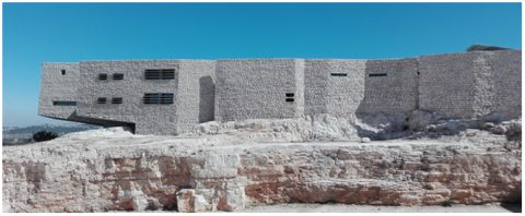
According to Khammash, ecology rather than culture is the real architect; “I think the ultimate architect is ecology, is not a religion, and is not even culture because ecology shapes culture.” He further added that what draws a distinction between one region over another is ecology; “Now the only thing is ecology, ecology will make me not make a New York house in Amman”. Khammash thinks that 99.999% of architecture, in this part of the world, is mainly geology; “I mean this house is wholly made of geology excluding wood because concrete, stone, steel, glass, and aluminum are all geology. Therefore, geology is a big warehouse that provides me with all these materials.” [19]. Among the most important achievements of Khamsh are Bahrani House, Nuqul House, and the Royal Academy for Nature Conservation, which competed for advanced positions in Aga Khan International Award (see Figure 1). The academy extends over an area of 3500.0 square meters. It included the following facilities: - Training rooms, a conference hall, a pavilion for the library with a computer lab, a medical clinic, a repository of equipment, and housing for the academy’s staff, an outdoor area for training in the discipline of search, rescue and climbing, information tourist center about the forests and activities visitors can do. The building's design referred to be Vernacular is determined by an informal local tradition, rather than by a particular designer. Furthermore, the harmony of a family of repeating forms with consistency in adaptive variations, such as the many beautiful parts also represents a great beauty when these parts are together, which is sometimes exhibited by neighborhoods and cityscapes created and maintained in a consistent common vernacular style. It is an epitome of the place to which it belongs and cannot be imported elsewhere [20].
Figure 1. The building of the Royal Academy for Nature Conservation (the researcher)
The architect Ayman Zuaiter is still searching in his works for a connection among stone, concrete, and the sky, by changing the formations in stone size and its thickness while neutralizing material physical factors so that they are capable of reaching a state of visual balance. The combination which fulfills contemporary needs with sensitivity to the local context and its variables is what Zuaiter views as the relationship between the local and the global: “The relationship between the local and the global; I do not know, the use of new tools, new materials all of these, how someone uses them to produce an architecture suitable for the place and modern requirements. Same time a place with its cultural dimensions; to produce a building that answers the modern needs, with modern tools, with the available tools, and it is a reflection of the specificity of place. So this was an attempt of how to have a building very vernacular but same time with a new vision”. Representing the enduring vernacular values in a contemporary Manner that fulfills the needs and aspirations of society [19].
This urban communication and interconnectedness are considered very important for connecting and linking the different successive generations in an architectural civilized cultural entity. The goal of this architectural approach is to achieve a reliable present; worthy and credible, which has firm-based roots and foundations derived from its past. Furthermore, a natural connection between the past and the future is attained for this cultural-architectural entity among different nations.
Due to the spread of the rock layers with specifications suitable for construction purposes, Jordan is characterized by the availability and diversity of building stones throughout history. Due to accessibility and low transportation costs, the population in every region in Jordan used building stones closest to their home areas. Limestone was in the northern, central, and western regions of Jordan, while Basalt was in the northeast and sandstone in the far south regions of Jordan [21]. Most likely, stone is named after the town where it was extracted or according to the physical characteristics that distinguish it from others. Once the stone is consumed in one site, another site will immediately be sought.
Although limestone is the one most quarried stone for construction purposes, a large variety of stone formations could be found in Jordan. While Natural stone is currently almost used as a cladding material, older whole stone houses were built from stone blocks. Even with the widespread of machine-dressed stone surfaces, it is still common to work manually on the surface of stone using a variety of tools. The colors, different surface treatments, the arrangement, and the size of the stone courses vary in stone facades and create variation [22]. The use of stone varies worldwide due to various reasons. One of them is the availability of its geological sources, which contain kinds of stones suitable in construction, the financial cost during the quarrying and manufacturing process, the speed required to complete the intended work, and the availability of specialized technical staff capable of dealing with this material. In Jordan, the stone material is still considered one of the main construction materials in building due to the availability of the previously mentioned artistic and technical factors. In addition to social factors resulting from the ostentation of stone constructions, which implies that the Jordanian society's acceptance and satisfaction with stone continue to grow and achieves many of the required benefits of its utilization. However, the change in dealing with stone in construction was evident. Nowadays, stone strength and hardness are no longer the only constructional elements. Thus, stone thickness becomes between (4 - 6 cm) and no longer dependent on the traditional construction methods, which depend on stone as a primary constructional part of a facade. Fixing stone, thus, requires adding mortar, concrete, and casting behind the stone. Placing it on top of other constructional elements after construction is considered a new technical method. The stone has become more aesthetic than constructional, thus, providing a natural stone facade and preserving the architectural style identity. To obtain the required specifications, stones are, therefore, subjected to various types of tests according to the Ministry of Public Labor technical specifications for public buildings such as: checking specific weight and absorption, stress rupture tests parameters, surface corrosion test, fracture stress test [23].
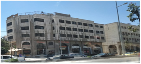
Recently, stone users and designers avoided using stone in construction in Jordanian architecture, especially in commercial and government buildings. This is due to the variances and instability of stone color of one facade. An evident change in the architectural facades built specifically from limestone existed because of the lack of stone quarries that provides limestone with high specifications and according to the required standards. In winter, western and southwestern facades are especially exposed to more rainfall and, thus, absorb more water than others. Furthermore, plenty of exhaust released from cars and industrial areas causes color changes in most polluted areas. This is evident in buildings in city centers and commercial streets with high traffic density (See Figure 2). Facades are sometimes painted with anti-moisture materials or using white cement in an attempt to maintain color stability. On the contrary, such practice led to distorting the building shape and, therefore, losing its aesthetic value and consequently, result in avoiding using natural stone replacing it with manufactured materials such as glass and Alucobond (See Figure 3).
Figure 2. The effect of weather factors on facades properties. Source (researcher)
Figure 3. The use of Alucobond cladding instead of limestone. Source (researcher)
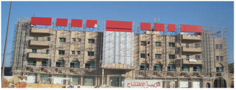
Some architects believe that globalization, which presented ready-made architectural models with steady characteristics serves the required purpose. Therefore, architects accepted ready-made manufactured materials without exerting any effort in solving the problem of the stone, which constitutes Jordan architectural style and identity. Consequently, the manifestation of globalization is reflected in architecture in Jordan as a result of the illogical integration of the new architectural approach. This approach promoted the liberalization of the dominant pattern from the traditional requirements of architecture and adopted the concept of free-market policy. Many modern architects have, therefore, neglected stone material replacing it with modern materials to meet the requirements of capital and modernity (See Figure 4).
As a result, the underestimation and lack of awareness of our rich architectural heritage in Jordan, unfortunately, led to the commencement of its destruction. What is currently happening is a method of replacing the architectural style built from stone material, which is based on cultural and historical references, and transforming it into buildings with glass or Alucobond that lacks the real relationship with the Jordanian style and environmental functions. The architect is, thus, confused when choosing between the prevailing and modern architectural style. This new architectural pattern was, unfortunately, not in favor of the Jordanian architecture and its style. However, it degraded its value, specifically in the latest years of the Jordanian architectural production. What distinguishes a given architecture with identity is its relationship with stone, in which a distinctive architectural style that depended on stone material rather than the formation and composition of the vernacular Jordanian architectural styles. When Jordanian architects imitated the international style of architecture using its materials in harmony with the new global culture, questions began to arise regarding the Jordanian identity and style. Do we have to follow globalization or maintain the vernacular architectural style? Ultimately, Jordanian architecture confronted a challenging position either to preserve the architectural identity distinguished by natural stone construction or to integrate with a globalization framework and its modern materials.
Figure 4. Using of alternative materials in commercial buildings in Amman. Source (researcher)
There is temperature disproportion in the semi-desert Jordanian climate in most regions of Jordan, where the temperature drops in winter, and sometimes reaches zero degrees Celsius. However, temperatures may rise to 35 degrees Celsius in summer with likely temperature disproportion during the same day, and may rise to more than ten degrees Celsius. Therefore, such climatic variations necessitate designing insulated buildings and using heat preservative materials to keep the temperature variations to a minimum. The functional requirements, thermal comfort, and cost-effectiveness of the materials used cannot be accomplished unless local natural materials are utilized even if advanced modern materials serve the same purpose. We should consider the climatic conditions, economic conditions, social customs, and most importantly protect the identity and architectural style of Jordan. The development of construction materials, building design, and the use of modern technology in design and construction are deemed necessary to keep up with the approaches of architectural development to preserve our heritage and customs since architecture is influenced by the environment. We must utilize all our surroundings properly using scientific and advanced methods and exert our efforts to develop the quarrying and manufacturing of stone material as a natural construction material that are used in Jordanian architecture for quite a long time.
Stone quarries in Jordan are characterized by various colors such as white, bright white, yellow, black, green, and pink, of which white is the most common. Many stone characteristics vary from one region to another according to its geological composition. Color differences appear as a result of several environmental factors or physical conditions (Natural) that affect the chemical composition and structure of a rocky stone. Accordingly, the properties and characteristics of rocks that make up the limestone must be identified [24]. Limestone is a sedimentary rock that precipitates chemically or biochemically consisting of Calcite (calcium carbonate). It is one of the most important widely used types of sedimentary rocks in Jordan, especially in mass limestone of the Cretaceous period in construction, cement industry, and for several other construction and road works. The higher the crystallinity of limestone, the better are its uses, especially for decorative and construction purposes [25]. Limestone spreads in many areas in the northern and southern regions of Jordan. Many promising areas require further studies to evaluate the quality of its limestone. The characteristics of current locations where limestone is queried are different [26-28]. For example, the limestone found in Azraq, eastern Jordan, consists of high porosity and low specific density. Whereas limestone rocks in Ma’am region, south of Jordan, consists of rocks with different types of fossils, which are the remains of living organisms or plants that were once buried and fossilized after their decomposition in sedimentary rocks over long periods. The building stones in Jordan, in general, are considered among the best building stones all over the world, especially in terms of high specific weight, low water absorption rate, and durability [25]. This differentiation among building stones in different regions indicates that there are factors that either decrease or increase the quality of the building stone. Khoury 2006 mentioned that what usually causes the low quality of building stones is the presence of cracks, joints, fossils, voids filled with sand and clay, and veins filled with secondary minerals such as calcite and quartz. It is worth mentioning that what also reduces the quality of the stone is the percentage of its water absorption, which can be studied by measuring the percentage of humidity, the density of its vegetation cover, and the relative change of stone temperature.
Due to their extensive uses, satellites have been used in the detection of geological sites to study the lithosphere, oceans, and the vegetation cover. Satellites being a source for scientific data collection contribute to the development and implementation of projects by making the right decisions at different times as well as the study of a certain region and obtain results that provide researchers with reliable and valuable scientific information [24, 29]. The tremendous progress in various fields of technology supported space technology development, which was mirrored in land monitoring space technology, such as the optical and thermal spectra of electromagnetic wavelengths. Research and development in this field are still in progress. Recently, the use of remote sensing data has been developed through new advanced satellite technologies and becomes significant for monitoring the land and through which we can obtain accurate future results able to interpret the land’s phenomena and to study various environmental issues [29, 30]. It is also considered one of the most important modern technologies that help us understand color changes in the terrestrial properties, including those related to the lithosphere. It also contributes to providing important spectral data in many industrial fields, especially the rocky layer, which constitutes a large area difficult for the researcher to study due to effort, time, and high financial costs. The rocky stone can be studied using the spectral reflection of land surface substances and mineral component analysis. The spectral reflection is a measurement of the amount of light reflected from the substance, where these color spectra appear in a satellite array in the form of color or ton converted into stored digital data. Studying the spectral reflectance data of terrestrial targets reduces the complexities resulting from environmental factors such as atmospheric absorption and scattering, vegetation cover, soil cover, and other factors, which enable us later to study and understand different rock characteristics. Rocks spectral reflection has been used to study the composition of the Moon, Mercury, and to a lesser extent Mars. Later it was decided to study sedimentary rocks [24]. After the launch of several satellites in 1976, remote sensing of sedimentary rocks occupied an important role, but remains a few [31].
Recently, the urbanization will be unique because of the existence of dense buildings and artificial structures. The increasing urbanization and buildings rate will eventually lead to the expedited consumption of non-renewable land resources such as water (on- and under-ground) and food [32, 33], and natural and energy resources such as buildings materials, oil, coal and gas—with environmental, social and economic impact on developing and developed countries alike [33, 34], as well as Urban growth refers to the transformation of the landscape from undeveloped to developed land [33, 35], and the expansion of urban areas and architectural style of buildings considered are a crucial change in terms of landscape transformation processes and urban sustainability. Therefor continuous spatial and temporal monitoring is required to evaluate and understand such changes. The capabilities of Remote sensing techniques make them a robust and reliable source of data for monitoring the expansion of cities at different spatiotemporal scales [35, 36]. Where that help remote sensing technologies allow identification of relations between buildings and urban categories and the structural patterns and consumption of natural resources, and hence the opportunity to explore relationships between the spatial distribution and patterns of buildings from architecturally point view.
Remote sensing technology can be used to develop the applying of sustainability in construction projects in terms of exploring natural resources and exploring the quantity and characteristics of materials that enter the construction industry and their impact on the local environment Based on the results of these discoveries, it is possible to link the future development of the construction industry, such as urban expansion, and how to deal with the properties of materials, and its cost can also be calculated.
This research uses data related to the factors used in studying limestone in the three study regions (Al-Ruwaished Region in the east of Jordan, Ma'an Region in the south of Jordan, and Ajloun Region in the north of Jordan). The geological formation was studied using maps and the geological data of the study regions. As for other factors, such as the presence of cracks, joints, percentage of water absorption, and the vegetation cover in addition to temperature changes have been studied using remote data sensing techniques, and geographical information systems through a group of spectral reflections of the rock formation of limestone in different locations through spectral data (visible light), (Near Infrared), and (Shortwave Infrared) in Landsat satellite. Related data to all previous factors have been obtained as follows:
1-Geological Formation: Studying and quarrying limestone in terms of availability and spread, and determining its locations was necessary to identify the geological formation of the limestone. This formation requires obtaining the available geological maps 1: 25000 or 1: 100,000 of study regions from the Natural Resources Authority (NRA) via the National Geological Mapping Project [37-39].
These maps contain the geological composition of the study regions. Knowing the geological composition is necessary to determine the degree of the presence of limestone, its thickness, and the rocky layers existing in the area. Geological maps also facilitate knowledge of the structural features that all contribute to identifying the most convenient regions for quarrying.
2-Eliciting the Percentage of Cracks and Joints: The measurement of cracks and geological joints and the identification of their spread locations known as the geological features that affect limestone were studied through remote sensing data. Images of Landsat 8 Operational Land Imager (OLI) / TIR satellite were obtained from the United States Geological Survey. The Tectonic Joints and cracks were shown by the lineaments of the linear mass density map for these cracks and joints. The PCI Geomatica software was used to extract and prepare the lineament density through a lineaments Analysis tool as well as the utilization of Geographical Information Systems techniques within the ArcGIS software. Lineament density is regarded as a constant factor since it takes a very long time to alter. However, its effect on the quarried rock pieces used in construction lies in the presence of fractures or cracks in the limestone. The higher the linear density of the rock, the lower is its quality and economic value in construction.
3-Estimating the Percentage of Water Absorption (Soil Humidity Percentage): This factor indicates to what extent rock's capability to conserve water and to what extent water influenced the region. The more water percentage available in a region, the less efficient limestone will be. Applying a set of spectral indicators developed to measure water absorption percentage using Landsat 8 OLI / TIR satellite images for each region can determine the percentage of water absorption in the study region. The water absorption percentage used in this study is the Normal Different Water Index (NDWI) where the water absorption percentage represents the natural percentage of reflection close to green and infrared rays. Many scientific studies related to environmental issues used NDWI. The water absorption percentage [40-42].
NDWI is calculated using the following equation [43]:
NDWI = (λG - λNIR) / (λ G + NIR)
4-Estimation of the Vegetation Cover Percentage: This factor indicates to what extent the rocky layer is influenced by the vegetation cover. The greater the percentage of the vegetation cover, the less efficient limestone will likely be. Furthermore, it is not economically feasible since the removal of the vegetation cover to utilize limestone adds up to the financial costs. On the other hand, the type of vegetation cover might affect the efficiency of limestone through its roots which are viewed as a secondary cause of cracks. Specifying these areas could be achieved by determining the density and the spread of the vegetation cover. Therefore, a set of spectral indicators were developed to serve this purpose using satellite images from OLI / TIR Landsat 8 for each region. The green factor used in this study is the Normal Different Vegetation Index (NDVI), where the NDVI represents the natural percentage of near to infrared light reflection. NDVI has been used in several scientific studies related to environmental issues and vegetation density [40, 44, 45]. NDVI is calculated using the following equation [46]:
NDVI = (λNIR- R) / (λ NIR + R)
where the NIR represents the reflection of near-infrared (λ 0.8) Micrometer, and infrared is the red reflection in the visible light areas of the spectrum R (λ 0.64) Micrometer "red".
5-Change in Temperature: The change ratio in temperature among seasons is the most important factor, which reflects the ability of limestone to maintain constant temperature over time. The temperature stability is considered a high quality of the limestone thermal insulation effectiveness. To specify the differences in temperature between regions during summer and winter and understand their changes was necessary to determine land temperatures. Among the methodologies used in this study to measure land surface temperature is the Split-Window to estimate the land surface temperature during various seasons using the thermal bands [47-50]. The Brightness Temperature is calculated through Spectral Radiation Tope of Atmosphere using the following equation [47, 51, 52].
Lλ = Mʟ * Qcal + Aʟ
where, Lλ represents the value of the highest spectral irradiance in the atmosphere, Mʟ (Multiplicative) is the rescaling factor of the band (radiance_mult_band_10 / 11), Aʟ is the additive value of the band (radi-ance_add_band_10 / 11) and Qcal is the Quantized Calibrated Pixel Value, which is the band image (10/11).
Table 1 shows the spectral irradiance constants and the pixel quantitative calibration values (Quantity minimum) and (Quantity maximum)) of the thermal bands of Landsat images (Landsat 8).
Table 1. Landsat 8 spectral radiance constants [51, 52]
|
Band |
Rescaling Factor for Landsat 8 |
|||
|
|
Aʟ |
Mʟ |
Min |
Max |
|
Band 10 |
0.000342 |
0.1 |
1 |
65535 |
|
Band 11 |
0.000342 |
0.1 |
1 |
65535 |
Based on the above, the brightness temperature value can be estimated through the thermal band converted to spectral irradiance using the available thermal constants in the space image metadata file, where the Brightness Temperature was calculated from the spectral irradiance using the following equation [53, 54].
$T=\frac{K_{2}}{\ln \left(\frac{k_{1}}{l \lambda}+1\right)}-273.15$
where, T is the brightness temperature, and K1 and K2 in the previous equation are constant thermal standard values. Lλ is the Tope of Atmosphere TOA, and 273.15 is the constant used to convert degree from Kelvin to Celsius [51-54].
Table 2. Landsat 8 TIRS Thermal constants [51, 52]
|
|
Landsat 8 |
|
|
Thermal constant |
Band 10 |
Band 11 |
|
K1 |
1321.08 |
1201.14 |
|
K2 |
774.89 |
480.89 |
In Table 2, K1 and K2 are constant thermal calibrations for the bands Landsat 8 and 4 thermal infrared [51, 52].
Land Surface Emission is a relative factor used to estimate the Land Surface Temperature included in the equation for measuring the temperature. The land surface-emission equation was calculated by estimating the greenness index, which is a natural percentage of red color, and the reflection and near red rays [50]. It takes into account the proportion of the vegetation cover in the area, which affects the emission percentage and Pv knowledge. After that, the LST is calculated in Celsius degrees, while the Land Surface Emission is calculated as follows [52, 54, 55].
$P v=\left(\frac{N D V I-N D V I m i n}{N D V I \max -N D V \operatorname{Imin}}\right)^{2} \quad e=0.004^{*} P_{v^{+} .0 .9}$
where, e/LSE indicates Land Surface Emission, Pv (Proportional Vegetation) which is the relative vegetation cover and NDVI is the Normal Different Vegetation Index. The equation used to calculate temperature is as follows:
LST = BT / 1 + (W * BT / P * ln (e)
where, LST is the land surface temperature for the given NDVI, BT is the brightness temperature, W is the wavelength. P is the estimated values of 1438 and E (e) is the Land Surface Emission.
Factors affecting the quality of limestone in the study regions were studied. The results for each factor were as follows:
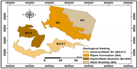
1-Geological Formation: The study indicated that certain geological formations spread in the study regions contain limestone in particular. These formations [25] indicate the availability of quarries used for quarrying building stones, especially mass limestone of the upper Cretaceous. The formations in the study regions vary in the discovered areas. The larger the area with less thickness, the more promising and economically feasible it is. Two of the most widespread formations were found in Al-Ruwaished region, namely Um Rijam and Al-Shallaleh formations, as shown in Figure 5. They consist of chalk and chalk Marl stone that alternate with thin layers of flint and Porcellanite in the lower part while the upper part consists of successive layers of flint, limestone, chalk, chalk limestone, Marl limestone, and limestone and flint nodules [37]. As for the Ma'an region, four geological formations are shown in Figure 6 which are: Amman-Wadi Sir, Um Rijam, Um Rijam-Wadi Shalala, and Wadi Shallala Formations. It was observed that there is a horizontal and vertical rock variation consisting of dolomitic limestone and mottled sandy dolomite, silt sand and clay, successive sandy rocks with thin layers of gluconate, and flint nodules in the upper part. Thick flint layers are also found in the regions which overlap with sand layers, Marl limestone, Fossil limestone, Phosphate limestone, sand limestone, phosphate, and quartz nodules in addition to yellow and red Marl, thin layers of Phosphate limestone, and Marl. In the upper part, there are yellow and white Marl, chalkstone, chalk limestone, and Marl limestone. Many fossils of shellfish, bones, and teeth of fish and other fossils are scattered in the geological layers of the study region [38]. Regarding Ajloun region, it was found that the most widespread formations that contain limestone are the Amman - Wadi Sir Formation as shown in Figure 7 where at least three mass units in the study region existed. They are Marl and dolomite limestone, and bleached grey to thick-bedded and thin-bedded limestone. In addition to the presence of fossils in the geological layers of the study regions [49], geological maps showed that mass limestone is present in all geological formations of the Study regions and that the difference between these formations is a difference in the additional content of the limestone. The additional content greatly affects the color and hardness of the limestone. However, the percentage of chalkstone and porcellanite (or porcelanite) in Al-Ruwaishid increases the whiteness of limestone whereas the decrease in fossils reduces the hardness of limestone. In Ma'an and Ajloun regions, the degree of the white color is reduced due to the overlap of phosphate limestone and yellow and red Marl, which, in turn, affect the color. Various fossils increase the hardness of limestone and the overlap in the bleached grey limestone. Based on the above, it can be taken into consideration that limestone still exists in the three study regions, with slight differences in its colors and hardness. The limestone in Ma'an and Ajlun was harder than in Ruwaishid. Whereas, Ruweished stone was purer and clearer in color than that of Ajloun and Ma'an. Ma'an stone is affected by Alhasa formation that contains phosphate rock.
Figure 5. Geological Formation of the Ruweishd Region
Figure 6. Geological Formation of the Maan Region
Figure 7. Geological Formation of the Ajloun Region
2-Cracks and joints: The study showed cracks and joints in terms of lineaments geology can be obtained by extracting lineament density using PCI Geomatica software through the Lineaments Analysis tool. Satellites showed that the average lineament density in the Study regions: Al-Ruwaished, Ma'an, and Ajloun were 0.78, 1.1, and 0.96 respectively. Table 3 showed that the Al-Ruweished region has cracks and structural separators in the limestone body less than any other study regions. Drawn from this conclusion, the percentage of joints and cracks in Al-Ruwaished stone is less than Ma'an stone and the proportion of joints and cracks in Ma'an stone is less than that of Ajloun. The presence of joints and cracks greatly affects the quality of the building stone. According to the specifications of the Jordanian Ministry of Public Works, the fewer joints and cracks, the greater the quality of stone in construction.
Table 3. The lineament density of the study regions
|
Lineament Density (Km/km2) |
||||
|
Min |
Max |
Mean |
SD |
|
|
Al-Rwayshed |
0.06 |
1.49 |
0.78 |
0.22 |
|
Maan |
0.04 |
1.97 |
1.1 |
0.32 |
|
Ajloun |
0.0 |
3.2 |
1.0 |
0.6 |
3-Water Absorption Percentage: The water absorption percentage values calculated for the Study regions ranged from 0 to 1. Results indicated that the water absorption percentage in the Study regions in winter and summer ranged between (-0.17 and -0.22) in Al-Ruwaished, (-0.14 and 0.2) in Ma'an, and (-0.2 and -0.3) in Ajloun. These results varied according to the season as shown in Table 4. Humidity values indicate low or high water content in limestone. Values close to zero are classified into regions of low humidity and high temperature leading to high-quality limestone due to the low percentage of water-absorbing materials. Values close to 1 are classified into regions of high humidity and low temperature, which mirror a high percentage of water-absorbing materials leading to low-quality limestone.
4-The Vegetation Cover: The greenness index used to calculate the vegetation cover values ranged from -1 to 1. The values of the vegetation cover in the study regions in winter and summer were as follows: Al-Ruweished (0.1 - 0.08), Ma'an (0.1 - 0.08), and Ajloun (0.2 to -0.2) Table 5. The negative value implies low-density vegetation cover (values close to zero mean barren soil). Low-density vegetation cover was severely affected by high temperature and the absence of water. Positive values imply a high-density of the vegetation cover, which indicates that regions with high values of the vegetation cover have low temperatures and rainfall. The percentage of vegetation cover implies excess water content in the stone previously mentioned. Besides, increased vegetation cover hinders the optimum utilization of limestone in the regions. The higher the density of the vegetation cover, the more difficult limestone is exploited.
Based on the above, preserving the green areas in Ajloun and the reduced quarrying costs makes the possibility of continuing to search for stone quarries in the Ma'an and Al-Ruwaished much more convenient than that of Ajloun. Simultaneously, Ma'an stone has the least vegetation cover but the most in humidity, while the AL- Ruwaishid has the least vegetation cover and humidity which increases its quality. The lower humidity stone, the greater its color stability and, therefore, unlikely affected by external factors.
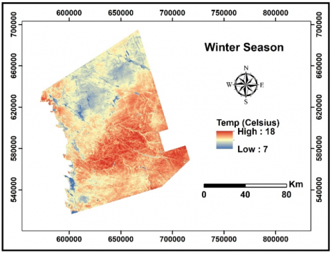
5-Temperature Change: The temperature change was studied in the three study regions. In winter and summer, according to maps, temperature values ranged between (45.9 - 14.4) degrees Celsius in the Ruwaished, (46.7 - 13.1) degrees Celsius in Ma'an, and (34.0 - 8.7) degrees Celsius in Ajloun. Table 6 and Figure 8 show that the minimum, maximum, and standard deviation values of the recorded surface temperature and the estimated land temperature of these regions have a high relationship with the type of geological formation of the study region. This is consistent with the study [39] which indicated a relationship between temperature and the geological composition of the region.
In general, the surface temperature may rise and fall evenly in all types of geological formations. However, the rise and fall are relative from one region to another, and that the differences in the rise and fall of temperatures were the least in Umm Al Rajam formation where the standard deviation of temperature reached 0.2℃ in winter while in Ruwaished it reached 1.2℃ in summer. It must also be noticed that the highest average temperatures for the three Study regions during various seasons were 45.9, 46.7, 34 for Al-Ruwaished, Ma'an, and Ajloun respectively.
The relative decrease in temperatures is likely due to a change in the composition of limestone. Consequently, this leads to an increase in its water absorbent substances, thus a decrease in temperature. The more water-absorbent material, the less the limestone land temperature which ultimately leads to a decrease in its quality in terms of the degree of thermal insulation. On the other hand, land temperature variation for limestone in the study regions was as a result of the variation in the vegetation cover in a region, which generally implies that the relationship between land temperatures and the vegetation cover was poor. By increasing the vegetation cover, the surface temperature will decrease, thus, prevents the surface rocky layer from absorbing the temperatures in summer and winter. These areas are considered dry and semi-arid most of the year. The highest increase in the geological formation of limestone in the Al-Ruwaished could be due to the lack of humidity in that region, the lack of vegetation cover, and the difference in the additional material content of the limestone components.
Table 4. The percentage of water absorption in winter and summer in the three study Regions
|
|
Winter |
Summer |
||||||
|
Min |
Max |
Mean |
SD |
Min |
Max |
Mean |
SD |
|
|
Al Rwayshed |
-0.4 |
0.26 |
-0.17 |
0.02 |
-0.45 |
0.32 |
-0.22 |
0.019 |
|
Maan |
-0.46 |
0.27 |
-0.14 |
0.03 |
-0.57 |
0.4 |
0.2 |
0.022 |
|
Ajloun |
-0.4 |
0.1 |
-0.2 |
0.1 |
-0.5 |
0.0 |
-0.3 |
0.1 |
Table 5. The density of vegetation cover in winter and summer in the study regions
|
|
Winter |
Summer |
||||||
|
Min |
Max |
Mean |
SD |
Min |
Max |
Mean |
SD |
|
|
Al-Rwayshed |
-0.27 |
0.45 |
0.08 |
0.013 |
-0.3 |
0.5 |
0.1 |
0.01 |
|
Maan |
-0.28 |
0.51 |
0.08 |
0.01 |
-0.38 |
0.65 |
0.1 |
0.14 |
|
Ajloun |
-0.2 |
0.5 |
-0.2 |
0.1 |
0.0 |
0.6 |
0.2 |
0.1 |
Table 6. The temperature change in winter and summer in the study regions
|
|
Min |
Max |
Mean |
SD |
Min |
Max |
Mean |
SD |
|
Al-Rwayshed |
7.08 |
18.13 |
14.4 |
1.3 |
28.8 |
50.4 |
45.9 |
1.3 |
|
Maan |
-1.3 |
18.9 |
13.1 |
1.4 |
28.6 |
53.1 |
46.7 |
2.2 |
|
Ajloun |
1.5 |
17.0 |
8.7 |
2.5 |
19.0 |
42.0 |
34.0 |
2.7 |
These results are match with study carried out by Ye et al. [56] that it mentioned there is a significant spectral correlation between building materials with a similar chemical composition. Therefore, construction material can be determined through the study of its spectral properties [57]. Where remote sensing data used to acquire more detailed spectral data by using a spectral sensor like Hyperspectral remote sensing (HRS) and Unmanned Aerial Vehicle (UAV) [58]. Thus, employing a hierarchical approach may enable the extraction of information about differentiated material composition, allowing mapping at the highest possible accuracy and reducing spectral confusion between materials [59], which mean there is an opportunity to mapping of the spatial distribution for materials that used in building using spectral data which provided by remote sensing techniques, this helps to provide natural and local materials, which will reflect positively on preserving the local architectural identity in Jordan and on the use of an environmentally friendly material that has good specifications in thermal insulation and absorption of sunlight, unlike manufactured materials that largely reflect sunlight and the rate of heat transfer in it is very high.
Figure 8. Temperature maps for winter and summer for the three study regions (Ruweished, Ma'an and Ajloun)
In conclusion, applying remote sensing data or satellite image capture data makes it is possible to explore various locations to quarry building limestone. Satellite image data capture also helps us identify the quality of stone and its characteristics, the percentage and the amount of humidity in limestone, and the change in temperature of the rock layers, in turn, reflects the quality and effectiveness of stone in thermal insulation in construction. The measurement of vegetation cover indicates the hardness of the stone, which is closely related to the stability in stone color, especially in regions with plenty of fumes and car exhaust. This information, which helps us increase the quality and specifications of stone material in construction, is used in improving the architectural product and constructional quality in terms of strength, hardness, and insulation efficiency.
1-Further study of the geological maps for all Jordanian regions to show the extent of limestone availability. These maps will, inevitably, serve as a guide for specialists in quarrying limestone.
2- Based on the findings of satellite image capture data, work in quarries should be organized by issuing work permits based on the quality of the stone initial reports and the environmental condition of the region. Green spaces are considered essential and must be left untouched.
3-A table for classifying quarried limestone from Jordanian quarries in each region in terms of specifications and characteristics should be prepared to serves as a reference frame for construction sector workers.
4-The quality and specifications of the stone should be associated with the method of construction as the limestone thickness used in construction varies according to the stone specifications and quarries’ sites.
5-Classification of the environmental condition of streets in cities and villages in Jordan related to pollution. The more polluted streets are the better stone quality should be used in terms of hardness and little water absorption to keep its color and aesthetic aspects.
6-Law and legislation governing architecture should be issued for both the owner and designer alike to comply with using the cladding materials for buildings to conserve the Jordanian distinguished architectural identity.
[1] Khaldūn, I. (1980). Muqaddamah-i Ibn Khaldūn, Bungāh-i Tarjumah va Nashr-i Kitāb P97 (Arabic version).
[2] Aldeek, Z.A. (2020). Green architecture and sustainability in the complex transformation of the built urban environment in Jordan. International Journal of Design & Nature and Ecodynamics, 15(1): 113-120. https://doi.org/10.18280/ijdne.150115
[3] Ababsa, M. (2013). Atlas of Jordan: History, Territories and Society. 32: Presses de l’Ifpo.
[4] Schmid, S.G., MacDonald, B., Adams, R., Bienkowski, P. (2001). The Nabataeans-Travellers between lifestyles. The Archaeology of Jordan, 367-426.
[5] Rababeh, S., El-Mashaleh, M., Al-Malabeh, A. (2010). Factors determining the choice of the construction techniques in Petra, Jordan. International Journal of Architectural Heritage, 5(1): 60-83. https://doi.org/10.1080/15583050903159737
[6] Paradise, T. (2014). Nabataean stone dressing and lithology in Petra, Jordan. American Journal of Archaeology, 118(4). https://www.researchgate.net/publication/270589765_Nabataean_Stone_Dressing_and_Lithology_in_Petra_Jordan.
[7] Rababeh, S., Al Rabady, R. (2016). Stone architecture: Stone dressing in Petra, Jordan. Further Studies in the History of Construction: The Proceedings of the Third Annual Conference of the Construction History Society. p. 87. https://books.google.jo/books?hl=en&lr=&id=4pbXDgAAQBAJ&oi=fnd&pg=PA87&dq=Stone+architectur.
[8] Al Bayari, O. (2005). New survey technologies for production of GIS model of the ancient roman Jerash city in Jordan. In Proceedings of the CIPA 2005 XX International Symposium.
[9] King, G. (1983). Byzantine and Islamic sites in northern and eastern Jordan. In Proceedings of the Seminar for Arabian Studies, 13: 79-91.
[10] Abi Alsha'ar, H. (1995). Irbid Wjweroha (Nahyet bani obaid) 1850-1925AD. pp. 29-32 (Arabic version). http://search.mandumah.com/Record/554015.
[11] Atiyat, D. (2015). The stone as a main building material. Journal of Multidisciplinary Engineering Science and Technology (JMEST), 2(4): 509-514. https://www.jmest.org/wpcontent/uploads/JMESTN42350314.pdf.
[12] Darke, D. (2020). Stealing from the Saracens: How Islamic Architecture Shaped Europe. Oxford University Press, 105.
[13] Abu Ghnemh, A., Ghosheh, A. (2000). Jordanian architects and the diversity of stone uses. In: Egypt ARo, editor. Arab Building Research of Materials Building and Economic Challenges Conference, p. 575 (Arabic version).
[14] Tarrad, M. (2020). A vision to revive mud architecture, a community heritage architecture in Jordan, for low income. International Journal of Design & Nature and Ecodynamics, 15(2): 269-275. https://doi.org/10.18280/ijdne.150218
[15] Dernie, D. (2003). New Stone Architecture. Laurence King Publishing.
[16] Pilder, A.D. (2011). Urbanization and identity: The building of Amman in the twentieth century. Doctoral dissertation, Miami University.
[17] Steele, J., Tukan, J., (2017). Poetry in Stone. Gulf Pacific Press. New York.
[18] Steele, J., Badran, R. (2005). The Architecture of Rasem Badran, Narratives on People and Place. Thames & Hudson. New York
[19] Jarrar, O.M. (2013). Cultural Influences in Jordanian Architectural Practices, Post 1990. pp. 156-157. https://doi.org/10.11575/PRISM/25503
[20] Tarrad, M., Abu-baker, D. (2020). A proposed new contemporary vernacular architecture as an expression of the spirit of age-design principles: A case study of Ajloun, Jordan. Architecture and Planning Journal (APJ), 25(1): 5. https://digitalcommons.bau.edu.lb/apj/vol25/iss1/5.
[21] Tarrad, M., Al-Omari, O., Mohammed, A.R. (2012). Natural stone in Jordan: Characteristics and specifications and its importance in interior architecture. Journal of Environmental Science and Engineering. B,1(6B): 720.
[22] Helmedag, I. (Ed.). (2012). Stone and Architecture in the Mountainous Regions of Jordan and Syria. DAAD.
[23] MPW. (1985). General Technical Specifications for Buildings, Civil Works, Architectural Issued by the Masonry Work Amman Jordan. In Arabic.
[24] Dagestani, N.S. (2003). Remote Sensing: Fundamentals and Applications. Balqa Applied University, Dar curriculum, Amman. In Arabic.
[25] Khoury, H. (2006). Industrial rocks and minerals in Jordan. Publications of the University of Jordan, Amman, Jordan.
[26] Mnaizel, S. (1998). Limestone: Decorative and building stone, Submitted to the Badia Research and development Programme HCST. In Arabic.
[27] Akkawi, K., Qubrusi, N. (1982). Properties of building stones in Jordan. Royal Scientific Society, Amman, 14.
[28] Kakish, N. (1986). Properties building stones in Jordan. Royal Scientific Society, Amman.
[29] Babayeva, N.A., Rustamov, R.B. (2013). Remote sensing and GIS applications in architectural design. In 9th International Conference on Technical and Physical Problems of Electrical Engineering (ICTPE-2013), Istanbul, pp. 433-4436.
[30] Ibrahim, M.M.F. (2014). The use of geoinformatics in investigating the impact of agricultural activities between 1990 and 2010 on land degradation in NE of Jordan. Logos.
[31] Hunt, G.R. (1970). Visible and near-infrared spectra of minerals and rocks: I silicate minerals. Modern Geology, 1: 283-300.
[32] Longley, P.A. (2002). Geographical information systems: will developments in urban remote sensing and GIS lead to ‘better’ urban geography? Progress in Human Geography, 26(2): 231-239. https://doi.org/10.1191/0309132502ph366pr
[33] Kadhim, N., Mourshed, M., Bray, M. (2016). Advances in remote sensing applications for urban sustainability. Euro-Mediterranean Journal for Environmental Integration, 1(1): 1-22. https://doi.org/10.1007/s41207-016-0007-4
[34] Ameen, R.F.M., Mourshed, M., Li, H. (2015). A critical review of environmental assessment tools for sustainable urban design. Environmental Impact Assessment Review, 55: 110-125. https://doi.org/10.1016/j.eiar.2015.07.006
[35] El Garouani, A., Mulla, D.J., El Garouani, S., Knight, J. (2017). Analysis of urban growth and sprawl from remote sensing data: Case of Fez, Morocco. International Journal of Sustainable Built Environment, 6(1): 160-169. https://doi.org/10.1016/j.ijsbe.2017.02.003
[36] Friedl, M.A., McIver, D.K., Hodges, J.C., Zhang, X.Y., Muchoney, D., Strahler, A.H., Schaaf, C. (2002). Global land cover mapping from MODIS: Algorithms and early results. Remote sensing of Environment, 83(1-2): 287-302. https://doi.org/10.1016/S0034-4257(02)00078-0
[37] Al-Qadi, M. (2008). The Geology of Ar Ruweishid. Amman: Natural Resources Authority of Jordan. pp. Map Sheet No. 365-IV. Geological Mapping Project (Arabic version).
[38] Tarawneh, K. (2002). The Geology of Ma’an. Jordan: Natural Resources Authority of Jordan, pp. Map Sheet No. 365-IV. Geological Mapping Project. (Arabic version).
[39] Abdelhamid, G. (1993). The Geology of Jarash. Amman: Natural Resources Authority of Jordan. Map Sheet No. 3154-I. Geological Mapping Project (Arabic version).
[40] Ibrahim, M., Kock, B., Datta, P. (2020). Evaluate the effect of land surface temperature in arid and semi-arid lands using potential remote sensing data and GIS techniques. International Journal of Global Warming (IJGW), 24(3/4). https://doi.org/10.1504/IJGW.2020.10031655
[41] Achmad, A., Muftiadi, M. (2019). The relationship between land surface temperature and water index in the urban area of a tropical city. In IOP Conference Series: Earth and Environmental Science, 365(1): 012013. https://doi.org/10.1088/1755-1315/365/1/012013
[42] Chen, W., Zhang, Y., Gao, W., Zhou, D. (2016). The investigation of urbanization and urban heat island in Beijing based on remote sensing. Procedia-Social and Behavioral Sciences, 216: 141-150. https://doi.org/10.1016/j.sbspro.2015.12.019
[43] McFeeters, S.K. (1996). The use of the Normalized Difference Water Index (NDWI) in the delineation of open water features. International Journal of Remote Sensing, 17(7): 1425-1432. https://doi.org/10.1080/01431169608948714
[44] Ibrahim, M., Al-Mashagbah, A. (2016). Change detection of vegetation cover using remote sensing data as a case study: Ajloun area. Change, 8(5):
[45] Chandrasekar, K. (2016). Geo-spatial Meteorological Products for Agricultural Drought Assessment, National Remote Sensing Centre (NRSC) User Interaction Meet- PPT.
[46] Carlson, T.N., Ripley, D.A. (1997). On the relation between NDVI, fractional vegetation cover, and leaf area index. Remote Sensing of Environment, 62(3): 241-252. https://doi.org/10.1016/S0034-4257(97)00104-1
[47] Ibrahim, M., Abu-Mallouh, H. (2018). Estimate land surface temperature in relation to land use types and geological formations using spectral remote sensing data in Northeast Jordan. Open Journal of Geology, 8(2): 174-185. https://doi.org/10.4236/ojg.2018.82011
[48] Rajeshwari, A., Mani, N.D. (2014). Estimation of land surface temperature of Dindigul district using Landsat 8 data. International Journal of Research in Engineering and Technology, 3(5): 122-126.
[49] Ghulam, A. (2010). Calculating surface temperature using Landsat thermal imagery. Department of Earth & Atmospheric Sciences, and Center for Environmental Sciences, 9829-9852.
[50] Alipour, T., Sarajian, M.R., Esmaeily, A. (2003). Land surface temperature estimation from thermal band of landsat sensor, case study: Alashtar city. The International Achieves of the Photogrammetry, Remote Sensing and Spatial Information Sciences, 38(4): 1-6.
[51] Landsat, N. (2015). Science Data Users Handbook. 2015-June.
[52] Potić, I., Bugarski, M., Matić-Varenica, J. (2017). Soil moisture determination using remote sensing data for the property protection and increase of agriculture production. In Worldbank Conference on Land and Poverty”, The World Bank, Washington DC.
[53] Lwin, K.K. (2010). Estimation of Landsat TM Surface Temperature Using ERDAS Imagine Spatial Modeler. SIS Tutorial Series, Division of Spatial Information Science.
[54] Saha, A., Patil, M., Goyal, V.C., Rathore, D.S. (2018). Assessment and impact of soil moisture index in agricultural drought estimation using remote sensing and GIS techniques. In Multidisciplinary Digital Publishing Institute Proceedings, 7(1): 2. https://doi.org/10.3390/ECWS-3-05802
[55] Rouse, J.W., Haas, R.H., Schell, J.A., Deering, D.W. (1974). Monitoring vegetation systems in the Great Plains with ERTS. NASA Special Publication, 351(1974): 309-317.
[56] Ye, C.M., Cui, P., Pirasteh, S., Li, J., Li, Y. (2017). Experimental approach for identifying building surface materials based on hyperspectral remote sensing imagery. Journal of Zhejiang University-SCIENCE A, 18(12): 984-990. https://doi.org/10.1631/jzus.A1700149
[57] Sadezky, A., Muckenhuber, H., Grothe, H., Niessner, R., Pöschl, U. (2005). Raman microspectroscopy of soot and related carbonaceous materials: Spectral analysis and structural information. Carbon, 43(8): 1731-1742. https://doi.org/10.1016/j.carbon.2005.02.018
[58] Ilehag, R., Schenk, A., Huang, Y., Hinz, S. (2019). KLUM: An urban VNIR and SWIR spectral library consisting of building materials. Remote Sensing, 11(18): 2149. https://doi.org/10.3390/rs11182149
[59] Franke, J., Roberts, D.A., Halligan, K., Menz, G. (2009). Hierarchical multiple endmember spectral mixture analysis (MESMA) of hyperspectral imagery for urban environments. Remote Sensing of Environment, 113(8): 1712-1723. https://doi.org/10.1016/j.rse.2009.03.018