Encounter Records and Possible Use of Human-Modified Aquatic Habitats by the False Gharial (Tomistoma schlegelii) in Musi Rawas Regency, South Sumatra

Harmoko Harmoko* | Dian Samitra | Fitria Lestari | Merti Triyanti | Indra Yustian
© 2026 The authors. This article is published by IIETA and is licensed under the CC BY 4.0 license (http://creativecommons.org/licenses/by/4.0/).
OPEN ACCESS
As a threatened crocodilian species, the false gharial (Tomistoma schlegelii) faces severe extinction risks. Historically documented in eastern peat swamps of South Sumatra, this study compiles contemporary encounter records in the province's western region, specifically Musi Rawas Regency. Data collection spanning 2016 to 2026 integrated targeted field verification at a high-conflict site with systematic digital data mining across online mass media and social networks. Through multi-marker morphological validation evaluated by crocodilian specialists, 14 unique encounter records were verified, with peak frequencies in 2021 and 2024 (4 records each). Standardized habitat categorization showed that 57.1% (8 records) occurred within human-modified aquatic environments, including primary/secondary irrigation canals and aquaculture ponds, while 42.9% (6 records) occurred in natural river systems. Although these opportunistic encounter records cannot be used to estimate population size or demography, they indicate the potential use of human-modified aquatic infrastructure by Tomistoma schlegelii. Overlapping resource use in both natural rivers and artificial canals has led to recorded human-crocodile conflicts, including physical injuries. Consequently, this study highlights the need for practical landscape-level management combining GIS-based conflict risk mapping, community awareness, and localized response units to support human safety and species survival in mixed-use landscapes.
adaptation, false gharial, irrigation networks, human-wildlife conflict, conservation strategy, Tomistoma schlegelii
The accelerating rate of land-use change in tropical regions has resulted in significant landscape transformations, converting natural ecosystems into agricultural fields, human settlements, and artificial water infrastructure [1]. From a conservation perspective, these environmental modifications often lead to habitat loss and fragmentation, posing severe challenges for large, wide-ranging predators [2, 3].
Indonesia hosts four crocodilian species: Crocodylus siamensis, Crocodylus novaeguineae, Crocodylus porosus, and Tomistoma schlegelii [4, 5]. The latter, commonly known as the false gharial or buaya sinyulong, is a large crocodilian characterized by its distinctive elongated snout [4, 6]. Ecologically, T. schlegelii shows a strong preference for peat swamp forests and low-gradient river systems with dense riparian vegetation [7]. Due to its naturally cryptic behavior and the widespread degradation of peatland habitats, the species remains relatively understudied while facing severe extinction risks [8, 9]. Consequently, T. schlegelii is classified as Vulnerable (VU) on the IUCN Red List, listed under CITES Appendix I, and fully protected under Indonesian law [8].
Historically, in South Sumatra Province, official records of T. schlegelii were concentrated in the eastern lowlands, particularly within the peat swamp ecosystems of the Lalan River basin in Banyuasin Regency [10]. While some crocodilian species are known to occasionally utilize human-dominated landscapes [11], documented encounter records for peat-swamp specialists like T. schlegelii in non-peatland, highly modified environments remain extremely limited [5].
Musi Rawas Regency, located in the western region of South Sumatra, has experienced substantial agricultural development and the expansion of artificial irrigation networks [9, 12]. In recent years, local media and community reports have increasingly noted opportunistic sightings, net entanglements, and captures of T. schlegelii within these irrigation canals and nearby aquaculture ponds [1]. These reports suggest that artificial water bodies may serve as alternative or temporary aquatic habitats, potentially influenced by ongoing environmental pressures on natural water bodies [9].
However, data regarding the presence of T. schlegelii in western South Sumatra primarily consist of opportunistic community sightings and rescue reports rather than long-term population surveys [5]. To address this knowledge gap, this study compiles and verifies encounter records of T. schlegelii in Musi Rawas Regency across a ten-year timeframe (2016–2026) [1].
By synthesizing direct observations and verified digital media mining, this study aims to: (1) document the contemporary geographic presence of T. schlegelii in western South Sumatra; (2) categorize the aquatic habitat types where encounters occurred to evaluate the possible use of human-modified environments; and (3) examine the implications for human-crocodile interactions to inform practical local targeted local risk mitigation strategies.
2.1 Study area and timeframe
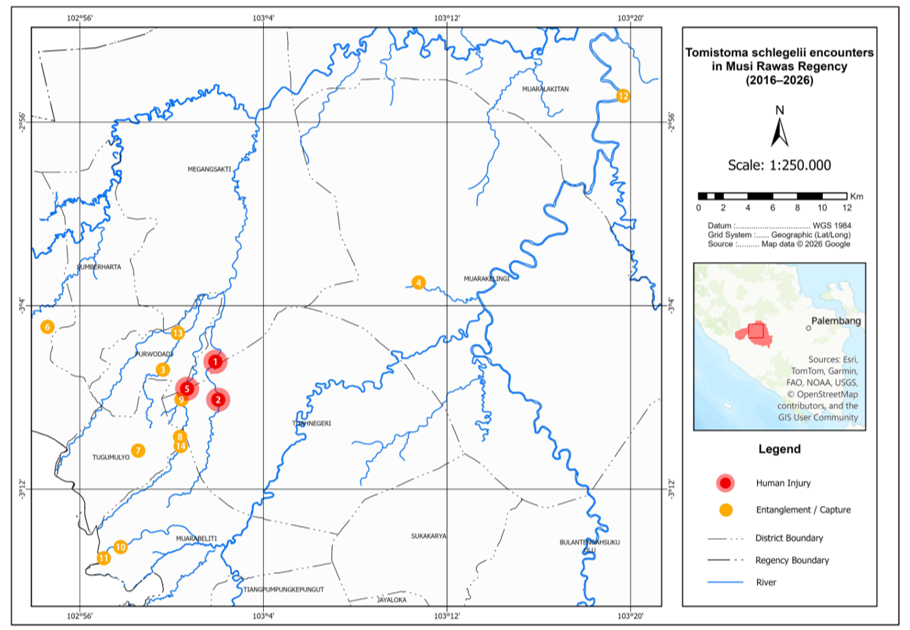
This study was conducted within the administrative boundaries of Musi Rawas Regency, South Sumatra Province, Indonesia. The monitoring, data mining, and field verification period covered a ten-year timeframe spanning from 2016 to 2026 (Figure 1).
Figure 1. Spatial distribution and interaction categories of Tomistoma schlegelii encounters in Musi Rawas Regency (2016–2026)
2.2 Habitat classification and conflict categorization
To ensure analytical consistency, aquatic habitats at encounter sites were standardized into three distinct categories:
1. Natural River Systems: Main river channels and natural tributaries (e.g., Lakitan and Kerambil rivers).
2. Irrigation Canals: Primary and secondary human-constructed agricultural waterways.
3. Aquaculture Ponds: Excavated private fish farming ponds.
Furthermore, habitats were broadly dichotomized into Natural (unmodified river systems) or Modified (human-made aquatic infrastructure). Each record was also categorized by Conflict Status: Conflict (incidents involving human injuries, livestock predation, or active trapping/retaliatory capture) or Non-Conflict (passive sightings or non-threatening observations).
2.3 Digital data mining and reproducibility protocol
To ensure reproducibility, digital data tracking was conducted systematically between November 2025 and January 2026 across targeted public platforms: Facebook, YouTube, and regional online news outlets operating in South Sumatra. Automated and manual queries were executed using combinations of Boolean operators and Indonesian keywords: "buaya Musi Rawas (Musi Rawas crocodile)" OR "buaya sinyulong (false gharial)" OR "buaya moncong panjang (long-snouted crocodile)" OR "penangkapan buaya Musi Rawas".
Data retrieval followed a structured four-stage screening framework:
1. Identification: Initial retrieval yielded raw digital posts, news articles, and social media videos related to crocodilian encounters in Musi Rawas Regency.
2. Screening: Articles and posts lacking visual media (photographs or videos) or those outside the administrative boundaries of Musi Rawas Regency were excluded.
3. Duplicate Removal: Duplicates, defined as identical encounter events covered by multiple news outlets or re-uploaded across different social media accounts, were merged into single unique records based on event date, specific village location, and matching physical features of the individual crocodile.
4. Verification and Archiving: All candidate records were independently evaluated by two verifiers (herpetological researchers) to assess morphological criteria (Tomistoma schlegelii diagnostic head and snout features). All verified source URLs, screenshots, video archives, and news metadata were systematically stored in a permanent digital repository for auditing.
2.4 Direct field observation and verification protocol
To systematically assess local habitat conditions and verify reported incidents, direct field observations were structured as an intensive, multi-session sampling campaign rather than an opportunistic site inspection. Fieldwork targeted the post-incident window on 6–7 June 2026 along a primary high-conflict stretch of the Lesing River (Megang Sakti Sub-district). The campaign comprised four discrete, timed observation sessions over two consecutive days (two sessions per day matching peak activity windows), yielding a combined active survey effort of 12 hours. While no additional follow-up visits were conducted beyond this two-day window due to field constraints, the standardized schedule and fixed-route design ensured systematic coverage across both morning and late-afternoon periods.
Direct site-based fieldwork was conducted by a small survey team (3 observers) operating under the following protocols:
1. Daytime Visual Surveys (08:00–12:00 WIB and 16:00-18:00 WIB): Strictly on-foot riverbank searches along accessible shoreline segments of a 2.5 km river stretch (no boats were used), conducted daily during the field campaigns to detect direct visual sightings of individuals, as well as basking signs, tracks, and physical habitat structures.
2. Geospatial and Visual Recording: Geographic coordinates for all key encounter sites and habitat features were recorded using the Google Maps application on a handheld mobile phone without dedicated hardware GPS devices, yielding an estimated spatial accuracy of 3–10 meters under open-sky conditions. Morphological documentation was carried out using a digital camera.
For all encounter records obtained via digital sources or community notifications, a strict two-step verification protocol was applied:
1. Morphological validation and diagnostic character set. To prevent misidentification, particularly when evaluating lower-resolution online photos or videos, species verification was not based solely on snout elongation. Instead, visual media were rigorously examined based on a comprehensive diagnostic character set specific to Tomistoma schlegelii. Snout and Skull Morphology: Extremely slender, tubular, and long snout (> 3 times longer than the width at the base) transitioning smoothly into the skull without prominent pre-orbital ridges. Dentition: Thin, sharp, needle-like teeth visible outside the upper jawline when closed, with a narrow mandibular symphysis. Coloration Pattern: Dark olive to yellowish-brown dorsal coloration with distinct broad black cross-bands on the torso and tail, alongside an unspotted yellowish-white ventral area. Scalation: Presence of 4–6 small post-occipital scutes and 4 large, contiguous nuchal scutes forming a distinct transverse band [8, 10, 13].
All candidate records were independently cross-examined and confirmed by two crocodilian/herpetological specialists to ensure accurate taxonomic distinction. Any record lacking clear visual documentation or failing to display these diagnostic markers was strictly excluded.
2. Spatial and chronological verification. Incident details were cross-verified down to the village and sub-district administrative levels through follow-up interviews (direct or via telephone) with eyewitnesses, local fishermen, pond owners, or village officials to establish exact coordinates, dates, and interaction circumstances [5]. To maintain data transparency, an "Evidence Source" column was integrated directly into Table 1 to explicitly categorize the provenance of each record (Direct Field Survey, Social Media Video/Post, Online News Report, or Direct Eyewitness Interview).
2.5 Methodological limitations and data interpretation
The temporal pattern observed from 2016 to 2026, including the peak occurrences in 2021 and 2024, must be interpreted with caution, as it may reflect variations in local news reporting, social-media visibility, or search engine data availability rather than a true biological expansion or conflict escalation. Furthermore, the 14 confirmed encounter records represent discrete spatial-temporal sightings rather than 14 distinct individuals or an active local population. Given the high mobility of crocodilians along interconnected water bodies, multiple records in adjacent areas may reflect repeated encounters with the same individual. Consequently, these opportunistic encounter data cannot be used to extrapolate population size, density, sex ratios, or local breeding status. Systematic mark-recapture, telemetry tracking, and dedicated nest surveys are required in future research to determine true population demography.
3.1 Spatial-temporal dynamics and encounter frequencies of Tomistoma schlegelii
Based on investigations, digital data extraction, and morphological verification spanning the ten-year period (2016–2026), a total of 14 unique encounter records of Tomistoma schlegelii were confirmed within the administrative boundaries of Musi Rawas Regency. This dataset provides a temporal encounter inventory for the species in the region.
Chronologically, the highest frequency of recorded occurrences was documented in 2021 and 2024, with each year accounting for 4 independent encounter cases across different sub-districts. However, this temporal distribution must be interpreted with caution. Rather than reflecting a true biological population growth or conflict escalation, these record peaks likely stem from reporting bias, increased social-media visibility, higher smartphone penetration, and varying online news search availability during those specific periods. The detailed chronological encounter records, including administrative locations, habitat settings, and interaction classifications, are presented in Table 1.
These encounter records confirm that the spatial range of Tomistoma schlegelii in South Sumatra Province extends beyond its historically documented strongholds in the eastern lowland peat swamps (e.g., Banyuasin Regency; [7]) to include verified, repeated encounters in the western inland region of Musi Rawas Regency.
Table 1. Encounter records, habitat types, and classified interaction categories of Tomistoma schlegelii in Musi Rawas Regency (2016–2026)
|
No. |
Location/Administration |
Habitat Type |
Year |
Interaction Category |
Evidence Source |
Interaction Details / Chronology |
|
1 |
Lesing River, Megang Sakti IV Village, Megang Sakti Sub-district |
Natural River |
2026 |
Human Injury |
Direct Field Survey & Eyewitness Interview |
Attacked a resident, causing injuries. |
|
2 |
Suban River, Leban Jaya Village, Tuah Negeri Sub-district |
Natural River |
2025 |
Human Injury |
Online News Report |
Attacked a resident, causing injuries. |
|
3 |
Lesing River, Sadarkarya Village, Purwodadi Sub-district |
Natural River |
2024 |
Passive Sighting |
Social Media Video (Facebook) |
Sighted swimming beneath a bridge. |
|
4 |
Kerambil River, Lubuk Tua Village, Muara Kelingi Sub-district |
Natural River |
2024 |
Entanglement/ Capture |
Online News Report |
Entangled in a local fishing net. |
|
5 |
Lesing River, border of Sadarkarya and Leban Jaya Villages, Purwodadi Sub-district |
Natural River |
2023 |
Human Injury |
Online News Report |
Attacked a resident, causing injuries. |
|
6 |
Paduraksa Village, STL Ulu Terawas Sub-district |
Aquaculture Pond |
2023 |
Aquaculture Loss |
Social Media Video (Facebook) |
Preyed on cultivated fish in a private pond. |
|
7 |
Sidoharjo Village, Tugumulyo Sub-district |
Irrigation Canal |
2021 |
Entanglement/ Capture |
Social Media Post |
Trapped in a floodgate; rescued by locals. |
|
8 |
Wonorejo Village, Tugumulyo Sub-district |
Irrigation Canal |
2021 |
Passive Sighting |
Social Media Post |
Sightings near residential area/washing site. |
|
9 |
Leban Jaya Village, Tuah Negeri Sub-district |
Irrigation Canal |
2021 |
Passive Sighting |
Social Media Video (Facebook) |
Sighted crossing an agricultural canal. |
|
10 |
Air Satan Village, Muara Beliti Sub-district |
Irrigation Canal |
2020 |
Passive Sighting |
Online News Report |
Surface sighting at night. |
|
11 |
Air Satan Village, Muara Beliti Sub-district |
Irrigation Canal |
2019 |
Entanglement/ Capture |
Online News Report |
Entered settlement canal; captured by locals. |
|
12 |
Lakitan River, Muara Lakitan Sub-district |
Natural River |
2019 |
Passive Sighting |
Social Media Video |
Sighted swimming in a natural river. |
|
13 |
Trikarya Village, Purwodadi Sub-district |
Aquaculture Pond |
2018 |
Aquaculture Loss |
Online News Report |
Preyed on cultivated fish in a private pond. |
|
14 |
Wonorejo Village, Tugumulyo Sub-district |
Irrigation Canal |
2016 |
Entanglement/ Capture |
Online News Report |
Entangled in a local fishing net deployed within an irrigation canal. |
The observed temporal pattern from 2016 to 2026 requires careful interpretation. Rather than representing a true biological population expansion or a sudden escalation in crocodile numbers, the peaks recorded in 2021 and 2024 are largely attributable to reporting and detection biases [14, 15]. Increased smartphone adoption, expanded cellular coverage in rural sub-districts, and higher engagement with local social media platforms during these years significantly heightened the likelihood of opportunistically capturing and sharing crocodile encounters [16, 17]. Consequently, these temporal peaks reflect variations in public reporting visibility and search engine data availability rather than underlying demographic shifts in local Tomistoma populations.
The ten-year dataset reveals a notable temporal shift in the nature of reported human-crocodile encounters. Earlier records (2016–2021) were predominantly characterized by passive sightings, accidental net entanglements, or entrapment in irrigation floodgates. In contrast, interactions documented between 2023 and 2026 included direct physical encounters resulting in human injuries along the Lesing and Suban rivers. This shift does not necessarily indicate increased aggressiveness in T. schlegelii, but rather highlights intensifying spatial overlap between human water-use activities (e.g., fishing, bathing, and riverbank agriculture) and crocodile movement corridors, thereby elevating the probability of accidental physical encounters [14, 18].
From a zoogeographical perspective, these verified encounter records extend the documented presence of T. schlegelii in South Sumatra Province beyond its historically recognized strongholds in eastern lowland peat swamps (such as Banyuasin Regency [7]) to include verified, repeated encounters in the western inland region of Musi Rawas Regency. However, in accordance with precautionary ecological principles, these 14 opportunistic encounter records confirm recent occurrence and repeated encounters [19, 20], but cannot be used to extrapolate population density, reproductive success, or long-term population stability in the regency.
3.2 Proportion of recorded encounters across aquatic habitat types
Historically, published records of Tomistoma schlegelii in South Sumatra have been centered on eastern peat swamp forest ecosystems, such as the Merang–Lalan hydrological system [8, 10]. The 14 verified encounter records in Musi Rawas Regency expand the known geographical occurrence of this threatened crocodilian in South Sumatra.
Among the total 14 opportunistic records collected, 57.1% (8 records) were documented within human-modified aquatic environments (primary/secondary irrigation canals and aquaculture ponds), while 42.9% (6 records) occurred in natural river systems. These percentages represent the proportions of recorded encounters within our opportunistic dataset and are not corrected for search or reporting effort. Therefore, they should not be interpreted as quantified habitat selection, preference, or true habitat-use rates, as total habitat availability and detection probabilities were not measured [21].
Similar utilization of human-modified waterways by T. schlegelii has been documented in degraded peat swamp landscapes in East Kalimantan and Sarawak, where artificial canals act as temporary corridors during seasonal water fluctuations [10]. high connectivity between natural tributaries (e.g., the Lesing River) and primary irrigation canals suggests that local water management infrastructure inadvertently facilitates crocodile movement, particularly during high-flow seasonal periods.
Rather than indicating permanent residency or true habitat preference, the presence of individuals within the Musi Rawas irrigation network likely reflects opportunistic dispersal between fragmented river segments. Open water-control infrastructure (such as unmonitored sluice gates) facilitates the ingress of crocodiles into agricultural waterways, effectively transforming drainage systems into functional dispersal pathways within highly modified anthropogenic landscapes [22, 23].
Furthermore, the ingress of crocodiles into artificial infrastructure is likely reinforced by localized resource attraction. Musi Rawas Regency features extensive freshwater aquaculture networks supporting high fish biomass, including cultivated species such as Oreochromis niloticus, Clarias sp., Channa sp., and Osteochilus vittatus. While artificial canals and aquaculture ponds lack the complex structural and hydrological features of natural peat swamps required for nesting and long-term reproduction, they provide temporary foraging refugia and movement corridors across agricultural landscapes.
3.3 Socio-ecological implications and human-wildlife interactions
To evaluate human-crocodilian interactions more precisely, verified encounters were classified into four distinct categories: passive sightings (n = 4), entanglements/captures (n = 5), aquaculture loss (n = 2), and human injury (n = 3) (Table 2). Notably, all physical injuries to humans (n = 3) occurred exclusively within natural river channels (the Lesing and Suban rivers) between 2023 and 2026 during direct water-use activities:
1. September 14, 2023 (Lesing River, Purwodadi District): A resident spearfisher in the late afternoon (16:00 WIB) sustained severe lacerations to the head and left hand. Species identity was confirmed as T. schlegelii based on the victim's detailed description of the characteristically narrow, elongated snout and corroborating local sighting reports.
2. August 3, 2025 (Suban River, Tuah Negeri District): A victim swimming across the river at 15:00 WIB suffered critical injuries resulting in the traumatic amputation of the left leg. The species was confirmed via the victim's description of the crocodile's slender, elongated snout.
3. January 13, 2026 (Lesing River, Megang Sakti District): A resident harvesting riverbank forage/grass at 09:00 WIB sustained bite wounds to the right thigh, witnessed and verified by nearby community members.
Table 2. Summary of Tomistoma schlegelii encounter categories by habitat type and timeframe (2016–2026)
|
Interaction Category |
Natural Rivers |
Human-Modified (Canals/Ponds) |
Total Records |
Temporal Occurrence |
|
Passive Sighting |
2 |
3 |
5 |
2019, 2020, 2021, 2024 |
|
Entanglement/Capture |
1 |
3 |
4 |
2016, 2019, 2021, 2021, 2024 |
|
Aquaculture Loss |
0 |
2 |
2 |
2018, 2023 |
|
Human Injury |
3 |
0 |
3 |
2023, 2025, 2026 |
|
Total |
6 |
8 |
14 |
2016–2026 |
Notably, all physical injuries to humans (n = 3) occurred within natural river channels (Lesing and Suban rivers) between 2023 and 2026 during direct water-use activities such as fishing or bathing. Between 2023 and 2026, a total of three attack incidents involving Tomistoma schlegelii were recorded in the study area. Each incident varied in terms of habitat context, victim activity, and injury severity (Table 1).
Conversely, interactions in human-modified landscapes consisted predominantly of non-fatal operational encounters, such as passive sightings, net entanglements/trapping in irrigation canals, and localized aquaculture predation. This distinction demonstrates that safety risks to human life are heavily concentrated along natural river stretches, whereas anthropogenic waterways primarily induce non-lethal infrastructure interactions and nuisance encounters [24].
The temporal sequence of these encounters suggests an evolving nature of human-crocodile interactions. Earlier records (2016–2021) involved passive sightings or accidental trapping in floodgates, whereas recent years (2023–2026) experienced direct physical attacks. The operational drivers underlying these conflicts vary by habitat type. Natural River Systems: Conflicts in natural rivers are driven by direct physical overlap during daily water utilization, such as fishing, bathing, sand mining, or riverbank vegetation collection. This shared spatial use significantly heightens the risk of accidental physical encounters [25, 26].
Modified Infrastructure (Canals and Ponds): Interactions in canals and private aquaculture ponds are impelled by animal movement corridors or localized resource attraction (e.g., opportunistic foraging on cultured fish). These intrusions frequently trigger local panic, leading to defensive trapping or retaliatory capture [27].
Shared spatial use of aquatic resources increases the risk of conflict for both local communities and crocodilian populations [28]. For communities, encounters cause severe safety hazards, physical trauma, and economic losses through aquaculture predation. For T. schlegelii, presence in anthropogenic spaces exposes individuals to risks of retaliatory killing, incidental net mortality, or permanent displacement [29].
Although several individuals captured by residents were successfully rescued and transferred to the South Sumatra Natural Resources Conservation Agency (BKSDA), reactive relocations alone are insufficient for long-term conservation. Sustainable management requires proactive landscape-level conflict mitigation, public risk awareness campaigns, and community-based monitoring networks [14, 15, 30].
3.4 Management considerations and practical recommendations
To manage human-wildlife interactions effectively and support the conservation of Tomistoma schlegelii in mixed-use agricultural landscapes, practical management strategies must combine spatial risk zoning, community involvement, physical infrastructure modifications, and rapid response mechanisms [31]. Based on the spatial distribution of encounter records and severe attack hotspots documented in this study, a tiered conservation and risk-mitigation priority matrix was developed for Musi Rawas Regency (Table 3).
Table 3. Proposed conservation and risk-mitigation priority matrix for Tomistoma schlegelii in Musi Rawas Regency based on recorded encounter and attack data
|
Priority Level |
Target Location (Village / Waterway) |
Incident History & Risk Level |
Recommended Action Plan |
Primary Target Group / Activity |
|
High Priority (Tier 1) |
Lesing River (Sadarkarya Village & Megang Sakti IV Village) |
Multiple recorded attacks (2023 & 2026), high frequency of sightings, spearfishing & foraging activities. |
1. Installation of high-visibility warning signage. 2. Establishment of Safe Water Points (Enclosed Bathing Enclosures). 3. Priority routine patrols by BKSDA/local rapid response team. 4. Targeted community workshops. |
Spearfishermen, forage gatherers, and riverbank residents. |
|
High Priority (Tier 1) |
Suban River (Leban Jaya Village) |
Severe incident resulting in traumatic amputation (2025), river crossing activity. |
1. Installation of warning signage at popular swimming/crossing points. 2. Infrastructure support (e.g., small footbridges/safe crossing points). 3. Community education on crocodile behavior and swimming risks. |
Local swimmers, river-crossing commuters, children. |
|
Medium Priority (Tier 2) |
Adjacent Waterways / Other Villages along Lesing System |
Sighting reports without severe attacks, secondary connectivity to conflict hotspots. |
1. School-based educational outreach. 2. Community-based reporting network setup (WhatsApp/Hotline). 3. Periodic monitoring by local conservation volunteers. |
Schoolchildren, teachers, and general riverine communities. |
|
Low to Medium Priority (Tier 3) |
Tugumulyo Irrigation Canals (Sidoharjo & Wonorejo), Muara Beliti/Air Satan Canals, and Aquaculture Ponds (Paduraksa & Trikarya) |
Entanglement/capture incidents (2016, 2019, 2021) and aquaculture fish loss (2018, 2023); no recorded human injuries. |
1. Biosecurity and fence enforcement for aquaculture pond owners. 2. Safe floodgate maintenance protocols for canal operators. 4. 3. Safe-release guidelines for fishermen when crocodiles are entangled in nets. |
Fish farmers, irrigation canal operators, and local fishermen. |
3.4.1 Spatial mapping and conflict risk zoning
Local conservation authorities (e.g., BKSDA South Sumatra) and municipal spatial planners can utilize Geographic Information System (GIS) mapping to delineate high-encounter hotspots along major river systems (e.g., the Lesing and Suban rivers) and interconnected primary irrigation canals [32]. Delineating conflict risk zones enables targeted resource allocation rather than broad, costly interventions. Installing clear, high-visibility warning signage in high-risk zones and constructing safe, barrier-protected community water access points (e.g., enclosed river-bathing enclosures) can effectively minimize direct physical overlap between residents and crocodilians during routine water-use activities [33].
3.4.2 Community education and public awareness
Although T. schlegelii has often been described as relatively less aggressive toward humans than Crocodylus porosus, the injury cases documented in this study demonstrate that serious attacks can occur when humans and crocodiles overlap at close range in riverine habitats [21]. Outreach should aim to prevent widespread panic and retaliatory killings while maintaining appropriate safety vigilance. Integrating local biodiversity conservation topics and river ecosystem awareness into regional school curricula can further enhance long-term conservation literacy among younger generations [34].
3.4.3 Localized response teams and co-management
Establishing localized conflict response units co-managed by BKSDA, local municipal authorities, village leaders, and community volunteers is essential for ensuring swift, coordinated responses to crocodile sightings or unexpected canal intrusions [35]. These community-based units should be equipped with standard reporting protocols, basic monitoring tools, and training in safe handling procedures. Implementing a rapid-response network mitigates public safety risks while reducing unnecessary mortality or permanent displacement of T. schlegelii individuals from regional aquatic networks [15].
This study presents an encounter inventory of Tomistoma schlegelii in Musi Rawas Regency, documenting 14 confirmed records between 2016 and 2026. These data confirm the presence of the species in the western region of South Sumatra Province, expanding beyond its historically documented range in the eastern lowlands. Among the confirmed records, 57.1% occurred within human-modified aquatic environments such as irrigation canals and aquaculture ponds, while 42.9% were recorded in natural river systems. Although these opportunistic encounter records do not constitute a systematic population or habitat-use survey, they indicate the potential use of human-modified aquatic infrastructure as alternative or secondary habitats. While local habitat alterations and landscape disturbances may serve as potential background drivers for these encounters, further quantitative land-cover change analyses are needed to verify these linkages. The spatial overlap between human activities and crocodile presence in these waterways has led to reported incidents of human-wildlife conflict, including physical injuries in recent years. To mitigate safety risks and prevent retaliatory actions against this threatened species, conservation management should focus on practical landscape-level measures, including GIS-based conflict risk mapping, public education on crocodile behavior, and the establishment of localized community-based response units.
During the preparation of this manuscript, the authors used gemini (google) solely for english grammar refinement and manuscript readability polishing. The authors reviewed and edited all content produced by the tool and take full responsibility for the final contents of the published article.
The authors express their deepest appreciation to University PGRI Silampari and Sriwijaya University for their institutional support during this collaborative research. They also thank the field assistants and the community of Musi Rawas Regency for their contributions to data collection and verification.
[1] Niebuhr, B.B., Cavalcanti, S.M.C., Vilalba, E.A., et al. (2025). Land use effects on the space use and dispersal of an apex predator in an ecotone between tropical biodiversity hotspots. Diversity, 17(6): 435. https://doi.org/10.3390/d17060435
[2] Carter, N., White, J.G., Bridgeman, W., Bradsworth, N., Ross, T.A., Cooke, R. (2025). Where to fly? Landscape influences on the movement and spatial ecology of a threatened apex predator. Landscape and Urban Planning, 253: 105218. https://doi.org/10.1016/j.landurbplan.2024.105218
[3] Lwin, Y.H., Quan, R.C., Hartig, F., Kühl, H.S., Heurich, M. (2025). Human and apex predators shape lower trophic levels through top-down control. Biological Conservation, 310: 111352. https://doi.org/10.1016/j.biocon.2025.111352
[4] Behler, N., Kopsieker, L., Staniewicz, A., Darmansyah, S., Stuebing, R., Ziegler, T. (2018). Population size, demography and diet of the Siamese crocodile, Crocodylus siamensis (Schneider, 1801) in the Mesangat Swamp in Kalimantan, Indonesia. Raffles Bulletin of Zoology, 66: 506-516.
[5] Shaney, K.J., Hamidy, A., Walsh, M., Arida, E., Arimbi, A., Smith, E.N. (2017). Impacts of anthropogenic pressures on the contemporary biogeography of threatened crocodilians in Indonesia. Oryx, 53(3): 570-581. https://doi.org/10.1017/s0030605317000977
[6] Suharno, S., Kadir, A., Sembiring, E., et al. (2021). Population estimation of freshwater crocodiles (Crocodylus novaeguineae) and tree vegetation diversity at wildlife reserve of Mamberamo Foja, Papua, Indonesia. Biodiversitas, 22(7): 2928-2936. https://doi.org/10.13057/biodiv/d220745
[7] Bezuijen, M.R., Webb, G.J., Hartoyo, P., Samedi. (2001). Peat swamp forest and the false gharial Tomistoma schlegelii (Crocodilia, Reptilia) in the Merang River, eastern Sumatra, Indonesia. Oryx, 35(4): 301-307. https://doi.org/10.1046/j.1365-3008.2001.00195.x
[8] Shaney, K., Shwedick, B., Simpson, B., Stevenson, C., Sideleau, B. (2019). Tomistoma Tomistoma schlegelii. Crocodiles. Status Survey and Conservation Action Plan, Fourth edition. Darwin: Crocodile Specialist Group.
[9] Miettinen, J., Liew, S.C. (2010). Status of peatland degradation and development in Sumatra and Kalimantan. AMBIO, 39(5-6): 394-401. https://doi.org/10.1007/s13280-010-0051-2
[10] Bezuijen, M.R., Shwedick, B.M., Sommerlad, R., Stevenson, C., Steubing, R.B. (2010). Tomistoma Tomistoma schlegelii. In Crocodiles. Status Survey and Conservation Action Plan, Third Edition, pp. 133-138. Crocodile Specialist Group, Darwin.
[11] Pereira, A.C., Nardoto, G.B., Colli, G.R. (2023). Sources of intraspecific variation in the isotopic niche of a semi-aquatic predator in a human-modified landscape. PeerJ, 11: e15915. https://doi.org/10.7717/peerj.15915
[12] Ulya, N.A., Nurlia, A., Premono, B.T., Waluyo, E.A., Yunardy, S., Martin, E. (2025). Understanding peat swamp forest transitions: Sustainability strategies and livelihood adaptation in Ogan Komering Ilir Regency, South Sumatra, Indonesia. Trees, Forests and People, 20: 100869. https://doi.org/10.1016/j.tfp.2025.100869
[13] Setiawan, A., Safri, A., Prima, B., Kadarisman, R., Indrianti, W., Oktaberi, R. (2019). Recent observation of false gharial (Tomistoma schlegelii) in the Sembilang National Park (TNS) area, Banyuasin Regency, South Sumatera Province. Biovalentia: Biological Research Journal, 5(1): 8-13.
[14] Sideleau, B., Staniewicz, A., Syah, M., Shaney, K.J. (2022). An analysis of tomistoma (Tomistoma schlegelii) attacks on humans. Marine and Freshwater Research, 73(11): 1331-1338. https://doi.org/10.1071/mf22015
[15] Pooley, S., Barua, M., Beinart, W., et al. (2017). An interdisciplinary review of current and future approaches to improving human–predator relations. Conservation Biology, 31(3): 513-523. https://doi.org/10.1111/cobi.12859
[16] Ardiantiono, Henkanaththegedara, S.M., Sideleau, B., et al. (2023). Integrating social and ecological information to identify high-risk areas of human-crocodile conflict in the Indonesian Archipelago. Biological Conservation, 280: 109965. https://doi.org/10.1016/j.biocon.2023.109965
[17] Maritz, R.A., Maritz, B. (2020). Sharing for science: High-resolution trophic interactions revealed rapidly by social media. PeerJ, 8: e9485. https://doi.org/10.7717/peerj.9485
[18] Larasati, F., Setiawan, Y., Kusrini, M.D. (2025). Potential habitats of Siamese crocodiles and false gharials in East Kalimantan for conflict resolution. Media Konservasi, 30(1): 154. https://doi.org/10.29244/medkon.30.1.154
[19] Aswani, S., Matanzima, J. (2024). Human–crocodile interactions in the western Solomon Islands: The importance of local data for reducing attacks on people. Oryx, 58(3): 344-346. https://doi.org/10.1017/s003060532300176x
[20] Murillo, L.P.P., Cambronero, E.M. (2020). Analysis of the interactions between humans and crocodiles in Costa Rica. South American Journal of Herpetology, 16(1): 26-33. https://doi.org/10.2994/sajh-d-18-00076.1
[21] Zhang, W., ElDidi, H., Masuda, Y.J., et al. (2023). Community-based conservation of freshwater resources: Learning from a critical review of the literature and case studies. Society & Natural Resources, 36(6): 733-754. https://doi.org/10.1080/08941920.2023.2191228
[22] Livesley, S.J., Marchionni, V., Cheung, P.K., Daly, E., Pataki, D.E. (2021). Water smart cities increase irrigation to provide cool refuge in a climate crisis. Earth’s Future, 9(1): e2020EF001806. https://doi.org/10.1029/2020ef001806
[23] Samways, M.J., Deacon, C., Kietzka, G.J., et al. (2020). Value of artificial ponds for aquatic insects in drought-prone southern Africa: A review. Biodiversity and Conservation, 29(11-12): 3131-3150. https://doi.org/10.1007/s10531-020-02020-7
[24] Manalo-Cadigal, G., Richards, R., Alcantara-Creencia, L., Manalo, R. (2024). Understanding socio-ecological complexity of mangrove-crocodile-fisher system of Bugsuk Island, Balabac, Palawan, the Philippines. Philippine Journal of Science, 153(4): 1393. https://doi.org/10.56899/153.04.13
[25] Cavalier, R., Pratt, E.N., Serenari, C., Rubino, E.C. (2021). Human dimensions of crocodilians: A review of the drivers of coexistence. Human Dimensions of Wildlife, 27(4): 380-396. https://doi.org/10.1080/10871209.2021.1953195
[26] Matanzima, J., Marowa, I., Nhiwatiwa, T. (2022). Negative human–crocodile interactions in Kariba, Zimbabwe: Data to support potential mitigation strategies. Oryx, 57(4): 452-456. https://doi.org/10.1017/s003060532200014x
[27] Baishya, A., Rao, T.K.S., Singh, A.K., Parmer, A. (2025). Human-wildlife conflict and management with special reference to India. Annual Research & Review in Biology, 40(5): 133-144. https://doi.org/10.9734/arrb/2025/v40i52246
[28] Ridwan, Q., Wani, Z.A., Anjum, N., Bhat, J.A., Hanief, M., Pant, S. (2023). Human-wildlife conflict: A bibliometric analysis during 1991–2023. Regional Sustainability, 4(3): 309-321. https://doi.org/10.1016/j.regsus.2023.08.008
[29] Lorand, C., Robert, A., Gastineau, A., Mihoub, J.-B., Bessa-Gomes, C. (2022). Effectiveness of interventions for managing human-large carnivore conflicts worldwide: Scare them off, don’t remove them. Science of The Total Environment, 838: 156195. https://doi.org/10.1016/j.scitotenv.2022.156195
[30] Sideleau, B. (2016). Notes on the current status of the saltwater crocodile, Crocodylus porosus, within East Nusa Tenggara Province, Indonesia. In 24th Working Meeting of the Crocodile Specialist Group of the Species Survival Commission of the IUCN, pp. 149-152.
[31] Reed, J., van Vianen, J., Barlow, J., Sunderland, T. (2017). Have integrated landscape approaches reconciled societal and environmental issues in the tropics? Land Use Policy, 63: 481-492. https://doi.org/10.1016/j.landusepol.2017.02.021
[32] Stahl, A.T., Fremier, A.K., Cosens, B.A. (2020). Mapping legal authority for terrestrial conservation corridors along streams. Conservation Biology, 34(4): 943-955. https://doi.org/10.1111/cobi.13484
[33] Storch, I., Cristescu, B., Fabiano, E. (2024). Human–wildlife conflict and coexistence in the African context. Wildlife Biology, 2025(1): e01432. https://doi.org/10.1002/wlb3.01432
[34] Harmoko, H., Rohman, F., Sumitro, S.B., Novianti, V. (2024). Unlocking the essence of conservation literacy: A systematic literature review. International Journal of Sustainable Development and Planning, 19(11): 4203-4217. https://doi.org/10.18280/ijsdp.191110
[35] Neira, F., Ribadeneira, S., Erazo-Mera, E., Younes, N. (2022). Adaptive co-management of biodiversity in rural socio-ecological systems of Ecuador and Latin America. Heliyon, 8(12): e11883. https://doi.org/10.1016/j.heliyon.2022.e11883