Eko Widi Santoso* | Tatang Padmawidjaja | Zulfahmi Zulfahmi | Iyan Haryanto | Edy Sunardi | Aminuddin Aminuddin | Mustafa Hanafi | Nandian Mareta | Umar Dani
© 2026 The authors. This article is published by IIETA and is licensed under the CC BY 4.0 license (http://creativecommons.org/licenses/by/4.0/).
OPEN ACCESS
Banda Aceh, located at the northern tip of Sumatra, is highly exposed to seismic hazards from the Sunda megathrust and the Sumatran fault system, with soft coastal sediments amplifying shaking and increasing the risk of liquefaction. This study delineated six seismotectonic source zones using earthquake data (1929–2022), estimated Gutenberg-Richter recurrence parameters, and performed probabilistic seismic hazard analysis (PSHA) with OpenQuake. Site conditions were characterized using Vs30, Multichannel Analysis of Surface Waves (MASW), microtremors, and geotechnical data to develop a geoseismic microzonation framework. Results indicate design-level ground motions of peak ground acceleration (PGA) = 0.30 g, SS = 0.65 g, and S1= 0.30 g, with dominant site classes SD (medium/stiff soil) and SE (soft soil) leading to two microzones: High Hazard (SD) and Very High Hazard (SE), both classified under seismic design category D according to SNI 1726:2019. The novelty of this study lies not only in the technical hazard assessment but in translating these microzonation outputs into ecodynamic spatial planning principles, where hazard zones are repurposed as green infrastructure, conservation areas, and nature-based evacuation corridors. By linking hazard science with land-use policies and ecological resilience, the findings of this hazard and microzonation study provide a scientific basis that can support the Sendai Framework priorities by informing spatial planning and land-use policies aimed at reducing future disaster risk. This integrated PSHA-microzonation-ecodynamic approach provides dual resilience: physical resilience against earthquakes and ecological resilience against environmental degradation, thereby strengthening Banda Aceh's long-term sustainability.
probabilistic seismic hazard, geoseismic microzonation, hazard-informed spatial planning, eco-resilient urban design, nature-based solutions, ecodynamic spatial planning, Banda Aceh, Indonesia
Banda Aceh, located at the northern tip of Sumatra, is among the most seismically vulnerable cities in Indonesia due to the combined influence of the Sunda megathrust and the Sumatran fault system. The catastrophic 26 December 2004 Sumatra-Andaman earthquake and tsunami, which claimed more than 160,000 lives and devastated critical infrastructure, underscored the city's profound physical and socio-economic fragility [1]. Although several regional seismic hazard studies have been conducted in northern Sumatra [2, 3], most have focused on macroscale probabilistic estimates and have not comprehensively integrated local site conditions into spatial planning and disaster risk reduction strategies. The coastal plains of Banda Aceh, dominated by Quaternary deposits, amplify ground motion and increase liquefaction susceptibility [4, 5], creating a complex hazard landscape that requires site-specific planning, targeted mitigation, and careful placement of densely populated areas and critical facilities in hazard-prone zones.
The research gap lies in the limited studies that explicitly connect probabilistic seismic hazard analysis (PSHA) with geotechnical microzonation using Vs30, Multichannel Analysis of Surface Waves (MASW), and microtremor data. There is also a shortage of frameworks that link technical hazard results to national seismic standards and urban resilience policies. While some regional hazard estimates exist [6, 7], they do not adequately account for site-specific amplification effects due to soft soils on Banda Aceh's coastal plain. Additionally, no framework currently translates these hazard results into practical spatial planning strategies that inform engineering and ecological land-use decisions. The novelty of this study is in integrating long-term earthquake catalogs and PSHA with site-specific geoseismic microzonation, directly aligned with seismic design categories [8]. It focuses on hazard assessment and microzonation as a basis for spatial planning, excluding comprehensive risk analyses such as building vulnerability or population exposure. Its results serve as scientific input for future risk assessments and land-use planning, providing design parameters for earthquake-resistant construction and a science-based foundation for Banda Aceh's spatial planning and resilience strategies (Figure 1).
Figure 1. Workflow of the geoseismic hazard microzonation study in Banda Aceh City, integrating seismotectonic analysis, probabilistic seismic hazard analysis (PSHA), site characterization, and risk assessment for sustainable land-use planning
A key contribution of this research lies in extending conventional hazard mapping through ecodynamic design principles. Rather than viewing earthquakes solely as a threat to be resisted through structural engineering, our ecodynamic approach treats geological dynamics as natural variables that must be addressed through landscape planning and open-space allocation. The resulting microzonation map functions not merely as a "red light" to restrict construction but also as a blueprint for allocating multifunctional green spaces-such as urban forests, parklands, and green evacuation corridors-that serve dual purposes: managing surface runoff, reducing the urban heat island, and providing community refuge during emergencies. It is critical to emphasize that while these ecological measures improve near-surface environmental conditions, they cannot replace deep ground improvement, soil reinforcement, or seismic engineering measures required for liquefaction mitigation and structural safety [9].
This perspective aligns directly with the core philosophy of urban ecodynamics, where energy and material flows between geological systems and human-made environments are managed harmoniously to achieve long-term, sustainable resilience. Such integration reflects recent advances that bridge technical hazard analysis with spatial planning and policy implementation, including urban microzonation studies in Southeast Asia [10], multi-model PSHA frameworks [11], and geospatial decision-support approaches for sustainable and resilient urban land-use planning [12]. By providing a hazard-informed spatial planning framework, this study offers a replicable methodology for other coastal cities facing similar seismic challenges, while acknowledging that the specific outputs are site-specific to Banda Aceh and should inform local planning, policy, and implementation.
2.1 Study area and tectonic setting
At the northernmost point of Sumatra, Indonesia, Banda Aceh City is situated in a tectonically active region influenced by both the Sumatran Fault and the Sunda subduction system. The oblique convergence of the Indo-Australian and Eurasian plates, partitioned between onshore strike-slip faulting and offshore megathrust slip, controls regional deformation [2, 3]. Banda Aceh is more vulnerable to site amplification and liquefaction due to its tectonic location and low-lying coastal plains, which are dominated by Quaternary deposits. The city is a crucial target for urban-scale seismic hazard assessment due to its active seismic sources and susceptible near-surface conditions [4, 7].
2.2 Earthquake catalogue and source zoning
2.2.1 Catalogue processing and completeness
The seismicity analysis was based on earthquake hypocenter and magnitude data obtained from the USGS catalogue for the period 1929–2022, within the region 92°–98.5°E and 2°–7°N, covering the main seismogenic structures affecting Aceh. The raw catalogue of 8,452 events was homogenized to moment magnitude (Mw) using conversion relations specific to the Sumatra region [13]. The minimum magnitude of completeness (Mc) was estimated using the maximum curvature method [14], yielding Mc = 4.2 for the entire period.
To avoid bias in the recurrence parameters, aftershocks were removed using the Gardner-Knopoff window method [15] with a temporal window of 5–20 days and a spatial window of 10–50 km (depending on magnitude). As a comparison, the nearest-neighbor method [16] was also tested, but the Gardner-Knopoff method was selected for its consistency with regional catalog processing standards. After declustering, the final catalogue consisted of 3,104 mainshocks. To assess uncertainty, the a and b values from the Gutenberg-Richter fit were estimated using the maximum likelihood method [17], and their 95% confidence intervals were calculated (e.g., b = 0.41 ± 0.05 for Z1).
2.2.2 Seismotectonic zoning and recurrence parameters
Based on regional tectonic and seismological information, six seismotectonic source zones (Z1–Z6) (Table 1) were delineated to represent megathrust (Figure 2), intraslab, and crustal earthquake sources [3, 18]. For each source zone, earthquake recurrence was quantified using the Gutenberg–Richter frequency-magnitude relationship [19].
logN = a – bM
where, N is the cumulative number of earthquakes with magnitude ≥ M, and a and b are constants. The corresponding a and b values were estimated by linear regression in log₁₀(N)-M space.
The resulting recurrence parameters are presented in Table 1. Figure 2 shows the seismotectonic zonations of Aceh and the North Sumatra region, delineating the six source zones (Z1–Z6) representing megathrust, intraslab, and crustal earthquake sources.
Table 1. Seismotectonic source model parameters for Banda Aceh probabilistic seismic hazard analysis (PSHA)
|
Zone |
Source Type |
Geometry |
M_min |
M_max |
a-value |
b-value |
Activity Rate ($\lambda$) |
|
Z1 |
Megathrust |
Interface, Dip: 15°, Depth: 10–50 km |
5.0 |
9.0 |
3.2475 |
0.4124 |
0.085 |
|
Z2 |
Megathrust |
Interface, Dip: 18°, Depth: 10–50 km |
5.0 |
8.5 |
2.1609 |
0.6628 |
0.042 |
|
Z3 |
Intraslab |
Distributed, Depth: 50–200 km |
5.0 |
7.5 |
3.1896 |
0.4253 |
0.120 |
|
Z4 |
Crustal |
Strike-slip, Depth: 0–30 km |
5.0 |
7.0 |
2.5502 |
0.3438 |
0.065 |
|
Z5 |
Crustal |
Reverse, Depth: 0–30 km |
5.0 |
6.5 |
2.7694 |
0.3041 |
0.048 |
|
Z6 |
Crustal |
Normal, Depth: 0–30 km |
5.0 |
6.5 |
2.2072 |
0.2627 |
0.038 |
Figure 2. Seismotectonic zonations of Aceh and the North Sumatra region, delineating six source zones (Z1–Z6) representing megathrust, intraslab, and crustal earthquake sources
2.2.3 Logic tree and ground motion prediction equations
To account for epistemic uncertainty in ground-motion prediction, a logic tree was implemented in the PSHA framework (Table 2 and Table 3). Ground motion prediction equations (GMPEs) for shallow crustal earthquakes [20-22] and subduction-zone attenuation models [23-25] were used. Epistemic uncertainty was represented using logic tree weighting in OpenQuake [11, 26].
Table 2. Logic tree structure and weights for ground motion prediction equations (GMPEs) in probabilistic seismic hazard analysis (PSHA)
|
Source Type |
GMPEs |
Weight |
|
Crustal |
Chiou and Youngs [22] |
0.33 |
|
Crustal |
Abrahamson et al. [23] |
0.33 |
|
Crustal |
Atkinson and Boore [24] |
0.33 |
|
Subduction Interface |
Bommer et al. [26] |
0.50 |
|
Subduction Interface |
Sulaeman and Solikhin [27] |
0.50 |
|
Subduction Intraslab |
Bommer et al. [26] |
0.50 |
|
Subduction Intraslab |
Sulaeman and Solikhin [27] |
0.50 |
Table 3. Gutenberg–Richter recurrence parameters for the six seismotectonic zones
|
Zone |
Gutenberg–Richter Law |
a |
b |
|
Z1 |
log(N) = 3.2475-0.4124 M |
3.25 |
0.41 |
|
Z2 |
log(N) = 2.1609-0.6628 M |
2.16 |
0.66 |
|
Z3 |
log(N) = 3.1896-0.4253 M |
3.19 |
0.43 |
|
Z4 |
log(N) = 2.5502-0.3438 M |
2.55 |
0.34 |
|
Z5 |
log(N) = 2.7694-0.3041 M |
2.77 |
0.30 |
|
Z6 |
log(N) = 2.2072-0.2627 M |
2.21 |
0.26 |
Table 2 presents the logic tree structure and weights assigned to each GMPE. For crustal sources (Z4–Z6), three NGA-West2 GMPEs were assigned equal weights of 0.33 each. For subduction interface (Z1, Z2) and intraslab (Z3) sources, two GMPEs were assigned weights of 0.5 each. The logic tree also incorporated alternative M_max values to reflect uncertainty in maximum earthquake potential: (i) M_max ± 0.2 with weight 0.5, and (ii) M_max as listed in Table 1 with weight 0.5.
2.3 Site-condition characterization and microzonation
Local site conditions were characterized using available Vs30 information, microtremor observations, MASW profiles, and published geotechnical data from Banda Aceh [4, 5, 27]. Specifically, Vs30 data were compiled from 20 MASW profiles, 35 microtremor single-station measurements [27], and 15 borehole logs with SPT data [4, 5]. The spatial distribution of site classes was generated using ordinary kriging interpolation in ArcGIS, constrained by the geological map of Banda Aceh. The Vs30 map was then reclassified into site classes in accordance with SNI 1726:2019 [8].
Analysis of Vs30 data confirms that no locations within the administrative boundary of Banda Aceh yield Vs30 values ≥ 350 m/s. Geologically, the entire city is underlain by thick, unconsolidated Quaternary alluvial deposits-consisting of soft clay, silt, and fine sand-with no outcrops of hard rock or dense strata extending to the upper 30 m. Consequently, site classes SA (>1500 m/s), SB (760–1500 m/s), and SC (350–760 m/s) are not represented in the dataset, and only SD (medium/stiff soil) and SE (soft soil) classes are identified.
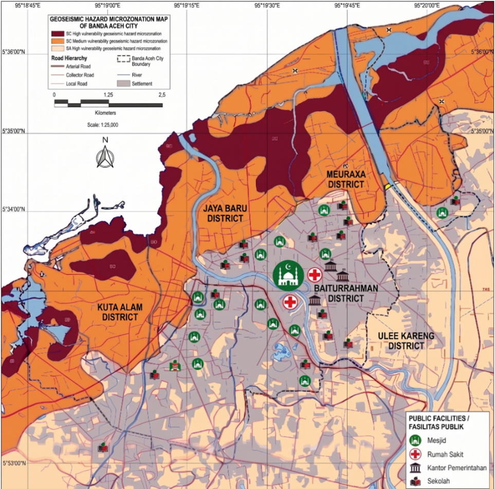
These datasets indicate that the city is predominantly underlain by soft-soil site classes SD and SE, particularly in coastal and alluvial areas, where sediment thickness and low stiffness may amplify seismic effects. The spatial distribution of site classes was integrated with the PSHA results to define two geoseismic hazard microzones: High Hazard for SD areas and Very High Hazard for SE areas. The resulting microzonation was then translated into code-relevant design parameters and seismic design categories in accordance with SNI 1726:2019 [8]. The site classification based on Vs30 is presented in Table 4.
Table 4. Site classification based on Vs30 [8]
|
Vs30 (m/s) |
Site Class |
Description |
|
175–350 |
SD |
Medium/stiff soil |
|
<175 |
SE |
Soft soil |
3.1 Seismotectonic zoning and recurrence parameters
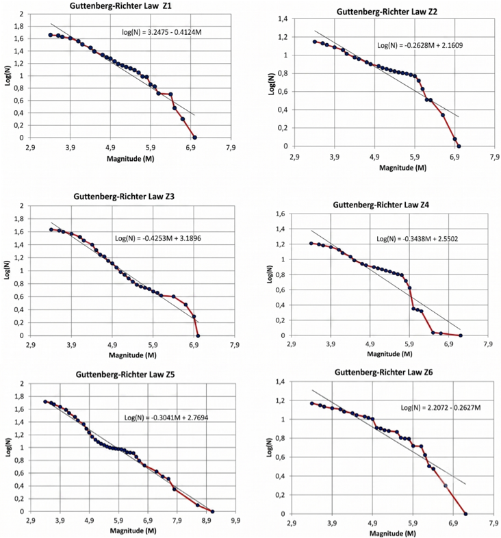
The seismotectonic model developed for Banda Aceh comprises six source zones (Z1–Z6) representing the main megathrust, intraslab, and crustal earthquake sources affecting the study area. Gutenberg-Richter analysis for these zones produced b values ranging from 0.26 to 0.66, indicating variability in earthquake recurrence characteristics across the regional tectonic domains. Figure 3 shows the Gutenberg–Richter recurrence relationships for zones Z1–Z6, illustrating the log-linear frequency–magnitude distributions used to define the seismicity rates in the PSHA. The resulting a and b values form the basis of the seismicity input used in the PSHA model (Table 3).
Rupture length for each source zone was estimated using the empirical relationships of Wells and Coppersmith (Table 5).
Table 5. Magnitude-rupture length relationships [28]
|
Rupture Type |
Relationship |
*a* |
*b* |
Sigma |
|
All Types |
log(L) = -3.22 + 0.69 Mw |
-3.22 |
0.69 |
0.22 |
|
Strike Slip |
log(L) = -3.55 + 0.74 Mw |
-3.55 |
0.74 |
0.23 |
|
Reverse |
log(L) = -2.86 + 0.63 Mw |
-2.86 |
0.63 |
0.20 |
|
Normal |
log(L) = -2.01 + 0.50 Mw |
-2.01 |
0.50 |
0.21 |
Figure 3. The Gutenberg–Richter recurrence relationships for seismotectonic zones Z1–Z6, showing the log-linear frequency-magnitude distribution for each source zone
3.2 Probabilistic seismic hazard analysis ground-motion parameters
The PSHA for a 2% probability of exceedance in 50 years (return period ≈ 2475 years) indicates that Banda Aceh is subject to high design-level ground motion. The estimated hazard values on rock (site class SB) at the city center coordinate (5.5483°N, 95.3238°E), extracted from the OpenQuake computation grid (0.02° × 0.02° resolution) using bilinear interpolation, are as follows:
•Peak ground acceleration (PGA) = 0.30 g (COV = 0.15).
•Ss (short-period spectral acceleration at 0.2 s) = 0.65 g (COV = 0.18).
•S1 (spectral acceleration at 1.0 s) = 0.30 g (COV = 0.20).
The uncertainty in the hazard estimates from the logic tree branches yielded a coefficient of variation of approximately 15-20% for PGA values, consistent with typical epistemic uncertainty in PSHA for subduction zones [11].
These results confirm that the city is exposed to substantial seismic loading from the combined effects of offshore subduction processes and nearby crustal sources (Figure 4).
Figure 4. Probabilistic seismic hazard map (PGA) for Banda Aceh City (10% probability of exceedance in 50 years), showing hazard zones (Low, Medium, High) and key landmarks
Figure 4 presents the probabilistic seismic hazard map of Banda Aceh City, illustrating spatial variations in PGA with a 2% probability of exceedance in 50 years, derived from OpenQuake analysis [27, 29]. The map shows spatial variation of PGA across Banda Aceh City, incorporating site amplification effects based on the Vs30 distribution. PGA values range from <0.10 g (low hazard, green) to >0.50 g (high hazard, red), with contour lines marking critical thresholds (0.25 g, 0.30 g, 0.40 g). The 0.30 g design value reported in the text corresponds to the median hazard at the city center on rock conditions (site class SB). At the same time, the map shows how this value varies across different site classes and locations across the city. The map includes key landmarks (Masjid Raya Baiturrahman, RSUD Meuraxa, Governor's Office, Universitas Syiah Kuala, etc.) and probability classes (High, Medium, Low). These results emphasize the elevated seismic hazard in coastal and alluvial areas, offering essential guidance for earthquake-resistant design and land-use planning [6, 30].
3.3 Site class distribution and microzonation
Published microtremor, MASW, and Vs30 studies indicate that Banda Aceh can be broadly separated into two dominant site classes-SD and SE-reflecting variations in sediment thickness and stiffness across the coastal plain (Table 6, Table 7, and Table 8). Integration of these site classes with the PSHA results yields two geoseismic hazard microzones: High Hazard (SD) and Very High Hazard (SE).
Table 6. Simplified geoseismic hazard microzoning for Banda Aceh City
|
Microzone |
Site Class (Vs30) |
Hazard Level |
Key Parameters (PGA, Ss, S1) |
Area Coverage |
Recommendation |
|
High Hazard |
SD (175–350 m/s) |
High |
PGA = 0.30 g, Ss = 0.65 g, S1 = 0.30 g |
~45% |
Seismic Design Category D: Mandatory geotechnical investigation before construction |
|
Very High Hazard |
SE (<175 m/s) |
Very High |
PGA = 0.30 g, Ss = 0.65 g, S1 = 0.30 g |
~55% |
Seismic Design Category D: Site-specific response analysis required; prioritize green infrastructure |
Table 7. Seismic design parameters for microzones in Banda Aceh [8]
|
Microzone |
Site Class |
PGA (g) |
Ss (g) |
S1 (g) |
Fa |
Fv |
SMS (g) |
SM1 (g) |
SDS (g) |
SD1 (g) |
SDC |
|
High Hazard |
SD |
0.30 |
0.65 |
0.30 |
1.2 |
2.0 |
0.78 |
0.60 |
0.52 |
0.40 |
D |
|
Very High Hazard |
SE |
0.30 |
0.65 |
0.30 |
1.5 |
2.4 |
0.975 |
0.72 |
0.65 |
0.48 |
D |
Table 8. Elastic response spectra parameters [8]
|
Microzone |
Site Class |
T0 (s) |
TS (s) |
Sa at T0 (g) |
Sa at Ts (g) |
|
High Hazard |
SD |
0.154 |
0.769 |
0.52 |
0.52 |
|
Very High Hazard |
SE |
0.148 |
0.738 |
0.65 |
0.65 |
3.4 Implications for urban resilience, ecodynamics, and spatial planning
The classification of Seismic Design Category D indicates that a substantial portion of Banda Aceh’s built environment requires strict adherence to earthquake-resistant design principles. Accordingly, retrofitting programs for existing structures and rigorous enforcement of modern building codes for new development must be prioritized in the city’s local disaster action plan [8, 30]. For Risk Category IV facilities-including hospitals, emergency response centers, communication hubs, and disaster management offices-located within the Very High Hazard (SE) zone, the elevated SDS value of 0.65 g mandates either site-specific seismic response analysis or advanced protective systems such as base isolation or supplemental damping to ensure post-earthquake functionality (Figure 5), in accordance with SNI 1726:2019 [8].
From a regulatory and technical control perspective, the Very High Hazard (SE) zone shall be subject to the following requirements:
•Mandatory comprehensive geotechnical investigations-including standard penetration testing, shear-wave velocity profiling, and liquefaction potential assessment-prior to the issuance of any construction permit [4, 5];
•Restrictions on high-rise or irregular structures, unless the effectiveness of deep foundations or ground improvement techniques is verified through site-specific studies [9];
•Priority allocation of resources for retrofitting critical infrastructure and densely occupied buildings, particularly those constructed before the adoption of contemporary seismic design standards [30, 31].
Beyond technical and regulatory controls, these constraints create opportunities to reimagine SE zones as ecologically functional, multifunctional open-space systems (see Section 4.4).
3.5 Implications for disaster risk reduction
These findings provide a scientific basis to support the priorities of the Sendai Framework for Disaster Risk Reduction (2015–2030): Priority 1 (Understanding disaster risk) by quantifying hazard levels and site effects; Priority 2 (Strengthening disaster risk governance) by providing science-based inputs for spatial planning and building regulations; and Priority 3 (Investing in disaster risk reduction for resilience) by identifying zones where retrofitting, geotechnical mitigation, and ecological restoration can yield the greatest risk-reduction returns.
Therefore, the design parameters and microzonation presented here shall serve as the technical baseline for seismic design, land-use zoning, and prioritization of geotechnical investigations in Banda Aceh. Future revisions of the city's spatial plan should incorporate these hazard microzones to guide urban development away from the most vulnerable areas or impose appropriate engineering and ecological requirements [10, 32].
4.1 Seismic hazard implications
The results indicate that Banda Aceh is exposed to high design-level seismic hazard due to its proximity to both the Sunda megathrust and active crustal fault systems [3, 13]. The calculated ground-motion parameters are PGA = 0.30 g, Ss = 0.65 g, and S1 = 0.30 g. These values confirm that the city is subject to substantial seismic demand that must be considered in urban development and structural design. These findings are consistent with the regional tectonic setting of northern Sumatra and the severe impacts of past destructive earthquakes in Aceh, including the 2004 Sumatra-Andaman earthquake [1] and the 2016 Pidie Jaya event [33, 34].
An important outcome of this study is that regional hazard levels alone are insufficient to characterize earthquake effects in Banda Aceh because local site conditions strongly influence expected shaking intensity [10]. The predominance of soft-soil site classes SD and SE across the coastal plain indicates that sediment thickness and low shear-wave velocity are likely to amplify ground motion, particularly in reclaimed, alluvial, and water-saturated areas [4, 27]. This is also significant from a geohazard perspective because the same zones prone to amplification may be more susceptible to liquefaction and related ground failure [5, 31]. However, due to the absence of site-specific SPT/CPT data, liquefaction is discussed here as a potential risk that requires further investigation.
4.2 Microzonation framework and engineering applications
The microzonation framework developed in this study provides a practical bridge between regional PSHA outputs and site-specific engineering applications [10, 32]. By separating Banda Aceh into High Hazard (SD) and Very High Hazard (SE) zones, the analysis provides a clearer basis for prioritizing geotechnical investigations, land-use controls, and preliminary foundation design. The High Hazard zone (SD) covers approximately 45% of the city area, while the Very High Hazard zone (SE) covers approximately 55%, predominantly along the western coast and riverbanks. In particular, identifying Very High Hazard SE zones is important for critical facilities and densely populated areas, where simplified regional hazard maps may underestimate local amplification effects.
The derived design parameters further indicate that both major microzones fall within seismic design category D under SNI 1726:2019 [8]. From an engineering perspective, this classification implies the need for ductile structural systems, stricter detailing requirements, and more careful consideration of soil-structure interaction in future development [9]. For essential infrastructure, the present results should be treated as a screening-level basis for more detailed site response, liquefaction, and geotechnical analyses rather than as a substitute for site-specific investigation.
4.3 Preliminary validation of microzonation
A preliminary validation of the microzonation was conducted by comparing the delineated hazard zones with the distribution of liquefaction reports following the 2004 earthquake [5]. The reports of liquefaction and ground settlement were concentrated within the Very High Hazard (SE) zones, particularly in the coastal areas of Meuraxa and Kuta Raja, providing a qualitative consistency check. However, a quantitative validation using CPT data and post-event damage surveys is necessary for future refinement. This validation, while preliminary, increases confidence in the microzonation results and supports their use as a basis for spatial planning.
4.4 Ecodynamic and spatial planning perspectives
From an ecodynamic and spatial planning standpoint, this study extends beyond establishing development constraints to propose alternative land-use strategies aligned with the area’s seismic hazard characteristics. The SE zone, subject to high ground-motion amplification, can be strategically directed toward ecological functions that enhance overall urban resilience [10, 32].
To ensure practical and consistent prioritization of areas for conversion into green open spaces or ecological corridors, clear operational screening criteria are applied: geotechnically, eligible parcels are classified as SE site with Vs30 < 175 m/s, have a slope of 8% or less, lie at least 50 meters from riverbanks or the coastline, and contain no critical underground utilities or major infrastructure; spatially, sites should be located within 300 meters of residential areas to serve accessible evacuation needs, have a minimum contiguous area of 0.25 hectares or be connectable to form continuous corridors, and be reachable via secondary roads suitable for emergency vehicles; ecologically and administratively, priority is given to vacant land, low-productivity agriculture, or derelict structures with potential for at least 70% vegetation cover after restoration, as well as parcels that do not conflict with existing designated uses, preferably government-owned or with clear tenure allowing feasible acquisition.
Recommended uses include the development of multifunctional green open spaces, ecological restoration, and an integrated network of open areas linked to evacuation systems and conservation priorities. This approach embodies nature-based solutions (NbS), converting hazard-prone areas into ecological assets that deliver multiple co-benefits: carbon sequestration, groundwater conservation, and designated safe gathering spaces for emergency response [10, 32].
To support practical implementation, further development of a GIS-based land suitability assessment framework is recommended. This framework should systematically evaluate land tenure, population density, accessibility, and ecological value to prioritize land-use transitions, ensuring that planning balances disaster safety and environmental sustainability [10, 35]. It should be emphasized that green infrastructure complements, rather than replaces, necessary geotechnical improvements or appropriate foundation systems when construction is permitted, thereby strengthening comprehensive risk reduction strategies [9, 36].
4.5 Action matrix for implementation
Conversion of Very High Hazard zones into green infrastructure follows the operational screening criteria defined in Section 4.4, ensuring consistent and measurable site selection aligned with both hazard mitigation and ecological goals.
To bridge the gap between scientific outputs and practical urban management, this study proposes a comprehensive Action Matrix (Table 9) that translates the hazard and microzonation findings into concrete, actionable steps for multiple stakeholders. The matrix categorizes actions into nine priority areas: (1) regulatory enforcement of seismic design codes, (2) retrofitting of critical facilities, (3) integration into spatial planning (RTRW), (4) conversion of Very High Hazard zones into green infrastructure, (5) development of green evacuation routes, (6) public awareness and community engagement, (7) technical capacity building, (8) funding and institutional coordination, and (9) monitoring and evaluation. Each action specifies engineering requirements, green space functions, responsible agencies, priority level, monitoring indicators, and timeframe.
Table 9. Action matrix for implementation of the hazard-informed spatial planning framework
|
No. |
Action Category |
Specific Action |
Engineering/Planning Requirement |
Green Space Function |
Responsible Agency |
Priority |
Monitoring Indicator |
|
1 |
Regulatory & Building Code Enforcement |
Enforce SDC D for all new buildings in both High Hazard and Very High Hazard zones |
Site-specific geotechnical investigation; Ductile detailing; Soil-structure interaction analysis |
N/A |
Dinas PUPR; Dinas Perkim |
Immediate |
% of building permits with complete geotech reports |
|
2 |
Critical Facilities Retrofit |
Prioritize retrofitting of Risk Category IV facilities in Very High Hazard zones |
Site-specific response analysis; Base isolation; Advanced foundation systems |
N/A |
BPBD; Dinas PUPR |
High |
# of critical facilities retrofitted |
|
3 |
Land-Use Zoning & Spatial Planning |
Integrate microzonation map into Banda Aceh RTRW |
GIS-based hazard mapping; Zoning regulation revision |
Preserve natural drainage; Maintain ecosystems |
Bappeda; Dinas PUPR |
High |
Revision of RTRW to include hazard microzones |
|
4 |
Green Infrastructure & Ecological Corridors |
Convert Very High Hazard zones into multifunctional green open spaces |
Land acquisition; Master plan for urban forest; Soil improvement |
Evacuation points; Stormwater infiltration; Carbon sink; Biodiversity corridors |
DLHK; BPBD |
Medium-High |
Hectares of new GOS in Very High Hazard zone |
|
5 |
Evacuation Route & Shelter Planning |
Develop green evacuation corridors connecting Very High Hazard zones to safe areas |
Accessibility analysis; Capacity assessment |
Shade trees; Infiltration swales |
BPBD; Dinas Perhubungan |
High |
% of population within 500 m of evacuation route |
|
6 |
Public Awareness & Community Engagement |
Conduct CBDRR programs on hazard zones and evacuation |
Training materials; Evacuation drills |
Community stewardship of GOS |
BPBD; Dinas Pendidikan |
Medium |
# of community members trained; # of drills conducted |
|
7 |
Scientific & Technical Capacity Building |
Strengthen local capacity for hazard monitoring and mapping |
Continuous Vs30/MASW surveys; Training on OpenQuake |
Ecological monitoring integration |
Dinas PUPR; BMKG; BRIN |
Medium |
# of new measurement points; # of technical staff trained |
|
8 |
Funding & Institutional Coordination |
Establish multi-year disaster resilience fund |
Joint budgeting; Explore national/international funding |
Allocate budget for green infrastructure |
Bappeda; Dinas Keuangan |
High |
Annual budget allocation; % of funds disbursed |
|
9 |
Monitoring, Evaluation & Reporting |
Develop performance monitoring system |
Establish baseline data; Annual reporting |
Monitor ecological performance: canopy cover, infiltration |
BPBD; Bappeda; DLHK |
Medium |
Annual resilience scorecard; Public satisfaction survey |
4.6 Limitations and future research
Despite these contributions, several limitations should be acknowledged. The hazard estimates depend on assumptions regarding source zoning, recurrence parameters, and the selected ground-motion prediction equations [11, 37], all of which may influence the final hazard values. In addition, the site-class characterization relies on available Vs30, microtremor, MASW, and published geotechnical data, which may not fully capture local heterogeneity across the city [27, 35].
Furthermore, the study's limitations regarding Vs30 heterogeneity and GMPE selection should be elaborated on, along with future research plans. Specifically, future work should:
1. Refine the source model with updated earthquake catalogs and improved characterization of local fault systems.
2. Test alternative GMPE combinations to reduce epistemic uncertainty.
3. Increase the spatial density of near-surface measurements (Vs30, MASW, microtremor) across the city.
4. Validate the proposed microzonation against observed damage patterns and site response data [6, 32].
5. Conduct site-specific SPT/CPT investigations to confirm liquefaction potential in SE zones.
6. Incorporate socioeconomic aspects, including relationships with public facilities and community vulnerability, to strengthen multidisciplinary relevance and bridge technical outcomes to the disaster risk reduction agenda [11, 35].
This study developed a geoseismic hazard assessment and microzoning framework for Banda Aceh City by combining seismotectonic source zoning, earthquake recurrence analysis, PSHA, and site‑condition characterization. Results show that the design-level ground-motion parameters are PGA = 0.30 g, Ss = 0.65 g, and S1 = 0.30 g for a 2% probability of exceedance in 50 years. The site-condition analysis reveals that Banda Aceh is primarily covered by soft-soil classes SD and SE, which significantly affect local seismic response and enable the definition of two microzones: high-hazard (SD) and very-high-hazard (SE). According to SNI 1726:2019, both microzones are classified as seismic design Category D, highlighting the need for earthquake-resistant design and detailed geotechnical studies across the city.
Beyond providing a technical basis for spatial planning and seismic engineering, this study offers a pilot ecodynamic planning framework for Banda Aceh and other coastal cities in Indonesia. This framework demonstrates that geological hazard data (PSHA and microzonation) can catalyze the creation of urban spaces that are not only safe from earthquakes but also ecologically resilient and socio-economically sustainable. The strategic conversion of Very High Hazard zones into green open spaces and conservation corridors exemplifies how risk-informed land-use planning can simultaneously address disaster risk reduction, environmental quality, and community well-being, embodying the principles of harmony with nature.
These findings offer a solid basis for urban planning, preliminary engineering, and seismic risk mitigation in Banda Aceh. To improve future use, the framework should be expanded through comprehensive site investigations, better near-surface characterization, and further evaluation of model uncertainties, especially in areas with soft sediments and potential liquefaction. Future revisions of the city's spatial plan (Rencana Tata Ruang Wilayah) should incorporate these hazard microzones and ecodynamic recommendations to guide urban development away from the most vulnerable areas and to invest in green infrastructure as a long-term resilience strategy.
Eko Widi Santoso and Tatang Padmawidjaja: Conceptualization, Methodology, Formal analysis, Writing–original draft, Visualization. Zulfahmi Zulfahmi, Aminuddin Aminuddin, and Mustafa Hanafi: Investigation, data curation (seismotectonic zoning), and validation. Iyan Haryanto and Edy Sunardi: Resources, investigation, and data curation (site conditions). Nandian Mareta and Umar Dani: Software, formal analysis, and writing–review & editing.
The authors thank the centers of publicly accessible earthquake and geological datasets, such as the USGS earthquake catalogue and BMKG seismic data, which contributed to the hazard assessment in this research. They also appreciate their affiliated institutions for supporting the research.
|
PSHA |
Probabilistic Seismic Hazard Analysis |
|
Mw |
Moment Magnitude |
|
Mc |
Magnitude of Completeness |
|
a, b values |
Gutenberg–Richter parameters for frequency–magnitude relationship |
|
λ |
Annual activity rate |
|
N |
Cumulative number of earthquakes with magnitude ≥ M |
|
PGA |
Peak Ground Acceleration |
|
Ss |
Short-period spectral acceleration (0.2 s) |
|
S1 |
Spectral acceleration (1.0 s) |
|
M_max |
Maximum potential magnitude |
|
L |
Rupture length (km) |
|
Vs30 |
Average shear-wave velocity in the upper 30 m |
|
MASW |
Multichannel Analysis of Surface Waves |
|
SPT |
Standard Penetration Test |
|
SD |
Site Class D (medium/stiff soil Vs30 = 175–350 m/s) |
|
SE |
Site Class E (soft soil, Vs30 < 175 m/s) |
|
SDC |
Seismic Design Category |
|
Fa |
Site coefficient for short-period acceleration |
|
Fv |
Site coefficient for long-period acceleration |
|
SMS |
Maximum considered earthquake spectral response acceleration (short-period) |
|
SM1 |
Maximum considered earthquake spectral response acceleration (1.0 s) |
|
SDS |
Design spectral response acceleration (short-period) |
|
SD1 |
Design spectral response acceleration (1.0 s) |
|
T0 |
Lower transition period |
|
TS |
Upper transition period |
|
Sa (T) |
Elastic response spectrum acceleration at period T |
|
NbS |
Nature-based Solutions |
|
Ecodynamic Spatial Planning |
Spatial planning framework integrating geological dynamics and ecological resilience |
|
Green Infrastructure |
Urban green spaces, conservation corridors, and evacuation routes |
|
Sendai Framework |
International framework for disaster risk reduction (2015–2030) |
[1] Lay, T., Kanamori, H., Ammon, C.J., et al. (2005). The great Sumatra-Andaman earthquake of 26 December 2004. Science, 308(5725): 1127-1133. https://doi.org/10.1126/science.1112250
[2] Bradley, K.E., Feng, L., Hill, E.M., Natawidjaja, D.H., Sieh, K. (2017). Implications of the diffuse deformation of the Indian Ocean lithosphere for slip partitioning of oblique plate convergence in Sumatra. Journal of Geophysical Research: Solid Earth, 122(1): 572-591. https://doi.org/10.1002/2016JB013549
[3] Griffin, J., Nguyen, N., Cummins, P., Cipta, A. (2019). Historical earthquakes of the eastern Sunda Arc: Source mechanisms and intensity-based testing of Indonesia's national seismic hazard assessment. Bulletin of the Seismological Society of America, 109(1): 43-65. https://doi.org/10.1785/0120180085
[4] Jalil, A., Fathani, T.F., Satyarno, I., Wilopo, W. (2020). A study of liquefaction potential in Banda Aceh City following the 2004 Sumatra earthquake. International Journal of GEOMATE, 18(65): 147-155. https://doi.org/10.21660/2020.65.94557
[5] Tohari, A., Sugianti, K., Syahbana, A.J., Soebowo, E. (2015). Cone Penetration Test (CPT)-based liquefaction susceptibility of Banda Aceh City. Jurnal Riset Geologi dan Pertambangan, 25(2): 99-110.
[6] Irsyam, M., Cummins, P.R., Asrurifak, M., et al. (2020). Development of the 2017 national seismic hazard maps of Indonesia. Earthquake Spectra, 36: 112-136. https://journals.sagepub.com/doi/abs/10.1177/8755293020951206.
[7] Petersen, M.D., Dewey, J., Hartzell, S., et al. (2004). Probabilistic seismic hazard assessment for Sumatra, Indonesia and across the southern Malaysian Peninsula. Tectonophysics, 390(1-4): 141-158. https://doi.org/10.1016/j.tecto.2004.03.026
[8] Indonesia, S.N. (2019). SNI 1726: 2019 Tata cara perencanaan ketahanan gempa untuk struktur bangunan gedung dan non-gedung. Badan Standarisasi Nasional Indonesia, 8: 254.
[9] Kramer, S.L., Stewart, J.P. (2024). Geotechnical Earthquake Engineering. CRC Press.
[10] Salsabili, M., Saeidi, A., Rouleau, A., Nastev, M. (2021). Seismic microzonation in regions with complex surficial geology: A review and an example framework. Geoenvironmental Disasters, 8: 27. https://doi.org/10.1186/s40677-021-00198-8
[11] Bommer, J.J., Douglas, J., Scherbaum, F., Cotton, F., Bungum, H., Fäh, D. (2010). On the selection of ground motion prediction equations for seismic hazard analysis. Seismological Research Letters, 81(5): 783-793. https://doi.org/10.1785/gssrl.81.5.783
[12] Chaoui, G., Yaagoubi, R., Mastere, M. (2025). Integrating geospatial technologies and multi-criteria decision analysis for sustainable and resilient urban planning. Challenges in Sustainability, 13(1): 122-134. https://doi.org/10.56578/cis130109
[13] Scordilis, E.M. (2006). Empirical global relations converting MS and mb to moment magnitude. Journal of Seismology, 10(2): 225-236. https://doi.org/10.1007/s10950-006-9012-4
[14] Wiemer, S. (2000). Minimum magnitude of completeness in earthquake catalogs: Examples from Alaska, the western United States, and Japan. Bulletin of the Seismological Society of America, 90(4): 859-869. https://doi.org/10.1785/0119990114
[15] Gardner, J.K., Knopoff, L. (1974). Is the sequence of earthquakes in Southern California, with aftershocks removed, Poissonian? Bulletin of the Seismological Society of America, 64(5): 1363-1367. https://doi.org/10.1785/BSSA0640051363
[16] Zaliapin, I., Ben-Zion, Y. (2020). Earthquake declustering using the nearest-neighbor approach in space-time-magnitude domain. Journal of Geophysical Research: Solid Earth, 125(7): e2018JB017120. https://doi.org/10.1029/2018JB017120
[17] Aki, K. (1965). Maximum likelihood estimate of b in the formula log N = a-bM and its confidence limits. Bulletin of the Earthquake Research Institute, University of Tokyo, 43(2): 237-239. https://doi.org/10.15083/0000033631
[18] Meteorology, Climatology and Geophysics Agency (BMKG). (2019). Catalog of Significant and Damaging Earthquakes 1821 - 2018. Jakarta Meteorology, Climatology and Geophysics Agency 2019, Jakarta. https://perpustakaan.bnpb.go.id/inlislite/opac/detail-opac?id=1860.
[19] Gutenberg, B., Richter, C.F. (1944). Frequency of earthquakes in California. Bulletin of the Seismological Society of America, 34(4): 185-188. https://doi.org/10.1785/BSSA0340040185
[20] Boore, D.M., Stewart, J.P., Seyhan, E., Atkinson, G.M. (2014). NGA-west2 equations for predicting PGA, PGV, and 5% damped PSA for shallow crustal earthquakes. Earthquake Spectra, 30(3): 1057-1085. https://doi.org/10.1193/070113EQS184M
[21] Campbell, K.W., Bozorgnia, Y. (2014). NGA-west 2 ground-motion model for the average horizontal components of PGA, PGV, and 5%-damped linear acceleration response spectra. Earthquake Spectra, 30(3): 1087-1115. https://doi.org/10.1193/062913EQS175M
[22] Chiou, B.S.J., Youngs, R.R. (2014). Update of Chiou and Young's NGA model for the average horizontal component of peak ground motion and response spectra. Earthquake Spectra, 30(3): 1117-1153. https://doi.org/10.1193/072813EQS219M
[23] Abrahamson, N.A., Gregor, N., Addo, K. (2016). BC Hydro ground motion prediction equations for subduction earthquakes. Earthquake Spectra, 32(1): 23-44. https://doi.org/10.1193/051712EQS188MR
[24] Atkinson, G.M., Boore, D.M. (2003). Empirical ground-motion relations for subduction zone earthquakes and their application to Cascadia and other regions. Bulletin of the Seismological Society of America, 93(4): 1703-1729. https://doi.org/10.1785/0120020156
[25] Zhao, J.X., Zhang, J., Asano, A., et al. (2006). Attenuation relations of strong ground motion in Japan using site classification based on predominant period. Bulletin of the Seismological Society of America, 96(3): 898-913. https://doi.org/10.1785/0120050122
[26] Bommer, J.J., Scherbaum, F., Bungum, H., Cotton, F., Sabetta, F., Abrahamson, N.A. (2005). On the use of logic trees for ground-motion prediction equations in seismic hazard analysis. Bulletin of the Seismological Society of America, 95(2): 377-389. https://doi.org/10.1785/0120040073
[27] Sulaeman, C., Solikhin, A. (2017). Kelas situs tanah di Kota Banda Aceh berdasarkan nilai periode dominan mikrotremor. Jurnal Lingkungan dan Bencana Geologi, 8(3): 127-138. https://doi.org/10.34126/jlbg.v8i3.175
[28] Wells, D.L., Coppersmith, K.J. (1994). New empirical relationships among magnitude, rupture length, rupture width, rupture area, and surface displacement. Bulletin of the Seismological Society of America, 84(4): 974-1002. https://doi.org/10.1785/BSSA0840040974
[29] Pagani, M., Monelli, D., Weatherill, G., et al. (2014). OpenQuake engine: An open hazard (and risk) software for the global earthquake model. Seismological Research Letters, 85(3): 692-702. https://doi.org/10.1785/0220130087
[30] Rusydy, I., Idris, Y., Mulkal, et al. (2020). Shallow crustal earthquake models, damage, and loss predictions in Banda Aceh, Indonesia. Geoenvironmental Disasters, 7: 8. https://doi.org/10.1186/s40677-020-0145-5
[31] Munirwansyah, M., Munirwan, R.P., Listia, V., Putra Jaya, R. (2023). Sumatra-fault Earthquake Source Variation for Analysis of Liquefaction in Aceh, Northern Indonesia. The Open Civil Engineering Journal, 17: e18741495270939. https://doi.org/10.2174/0118741495270939230921154841
[32] Molnar, S., Assaf, J., Sirohey, A., Adhikari, S. (2020). Overview of local site effects and seismic microzonation mapping in Metropolitan Vancouver, British Columbia, Canada. Engineering Geology, 270: 105568. https://doi.org/10.1016/j.enggeo.2020.105568
[33] Idris, Y., Cummins, P., Rusydy, I., et al. (2022). Post-earthquake damage assessment following the 6.5 Mw earthquake on December 7, 2016, in Pidie Jaya, Indonesia. Journal of Earthquake Engineering, 26(1): 409-426. https://doi.org/10.1080/13632469.2019.1689868
[34] Muzli, M., Umar, M., Nugraha, A.D., et al. (2018). The 2016 Mw 6.5 Pidie Jaya, Aceh, North Sumatra Earthquake: Reactivation 2 of an Unidentified Sinistral Fault in a Region of Distributed Deformation. Seismological Research Letters, 89(5): 1761-1772. https://doi.org/10.1785/0220180068
[35] Allen, T.I., Wald, D.J. (2009). On the use of high-resolution topographic data as a proxy for seismic site conditions (Vs30). Bulletin of the Seismological Society of America, 99(2A): 935-943. https://doi.org/10.1785/0120080255
[36] Jihad, A., Muksin, U., Syamsidik, et al. (2023). Tsunami evacuation sites in Northern Sumatra (Indonesia) were determined using updated numerical tsunami simulations. Progress in Disaster Science, 18: 100286. https://doi.org/10.1016/j.pdisas.2023.100286
[37] Audemard, F.A.M., Michetti, A.M. (2011). Geological criteria for evaluating seismicity revisited: Forty years of paleoseismic investigations and the natural record of past earthquakes. Geological Society of America Special Study, 479: 1-21. https://doi.org/10.1130/2011.2479(00)