Sarah Jamal Jalil | Moutaz A. Al-Dabbas | Khansaa R. Al-Joboury*
© 2026 The authors. This article is published by IIETA and is licensed under the CC BY 4.0 license (http://creativecommons.org/licenses/by/4.0/).
OPEN ACCESS
The floristic survey of the Al-Muthana Desert recorded 74 species representing 27 families. Amaranthaceae was the most represented family, followed by Asteraceae and Poaceae, reflecting the prevalence of desert-adapted taxa. Species richness and diversity varied among the studied stations. St5 and St6 each contained 13 species, whereas St8 had the highest richness, with 24 species. The Shannon diversity index (H′) ranged from 2.370 to 2.880, and Pielou's evenness (J) ranged from 0.890 to 0.965. The consistently low dominance values (0.056–0.106) indicated relatively balanced plant communities. St8 exhibited the highest richness, whereas St5 and St6 exhibited the lowest. Euclidean distances indicated substantial differences among stations, with the greatest distance between St6 and St8 (4.767) and the greatest similarity between St2 and St3 (0.375). These results reveal marked spatial variation in vegetation composition and diversity across the Al-Muthana Desert and suggest that local habitat heterogeneity contributes to this variation.
geodiversity, sediment distribution, plant diversity, Al-Muthana Desert
The arid climate of the Al-Muthana Desert, which forms part of the southern Iraqi desert, controls the intensity and spatial distribution of morphoclimatic processes. Drought and desertification associated with global warming have adversely affected the region. The climate is characterized by very low and erratic precipitation, high temperatures, high potential evaporation, and persistent strong winds, which collectively enhance physical weathering and aeolian geomorphic processes. These climatic conditions, together with the geological and geomorphological setting, have resulted in the development of a dynamic desert environment. Although rainfall is infrequent, episodic high-intensity storms can occur. These storms may generate severe flash floods because of the area's lithology, slopes, drainage-network morphology, and surface-sediment properties [1, 2]. Also, desert environments are generally considered less susceptible to biological invasions because of their dry and harsh conditions [3].
Moreover, morphoclimatic processes develop under the influence of various natural factors, including geological structure, topographic configuration, climatic variability, sedimentological characteristics, and the availability and movement of surface water and groundwater. Interactions among geological-geotechnical and hydrological-hydraulic parameters and vegetation are critical for assessing landscape evolution and environmental vulnerability [4].
Existing studies of the Al-Muthana Desert have addressed several aspects of its environmental and geomorphological framework, highlighting the importance of this area as representative of the arid regions of southern Iraq. Previous research has focused on the geographical characterization of natural features, the influence of morphotectonics on topographic evolution, and the relationships among geodiversity, biodiversity, and selected landform units, such as the Al-Salman Depression. Climatic investigations have also assessed differences between bare desert surfaces and vegetated areas, including their implications for ecological functions and land-surface processes. Although these studies have made valuable contributions, detailed understanding of the interactions among climate, geology, geomorphology, and ecology remains limited [5].
Multidisciplinary studies are therefore required to improve assessments of environmental change and landscape evolution in this arid region [6].
Iraq's marked geographical, climatic, and ecological variability makes it an important center of plant diversity in the Middle East. Its diverse landscapes, including mountain ecosystems, steppes, riverine plains, wetlands, and extensive deserts, encompass strong environmental gradients that promote species richness and habitat differentiation. Plant life-history processes, such as seedling establishment, growth, and survival, are strongly controlled by climatic factors. Consequently, plant communities vary across both temporal and spatial scales. Iraq's environmental complexity likely supports a rich wild flora with diverse distributions and adaptations. The country is therefore an ecologically significant reservoir of biodiversity. In this context, the arid and semi-arid regions of Southwest Asia have received particular attention [7, 8].
The Al-Muthana Desert exhibits considerable sedimentological diversity. Its surface ranges from loose aeolian sands and gravels to fine, clay-rich sediments. These different substrates affect hydrological processes, particularly water infiltration, storage capacity, and soil-moisture retention [9]. Consequently, the spatiotemporal variation in sediment moisture is closely related to plant-community composition and vegetation distribution. Soil-water availability is determined by the rainfall regime, including precipitation amount, intensity, frequency, and seasonal timing. These factors affect the germination, establishment, and survival of desert plants. Accordingly, the interaction between sedimentological characteristics and rainfall processes is a major ecological driver regulating vegetation patterns, species composition, and ecosystem functioning in the Al-Muthana Desert [10-12].
Previous studies of the Al-Muthana Desert have examined its geology, geomorphology, climate, and ecology; however, the relationships among geological and sedimentary units, plant-diversity patterns, and community composition remain poorly understood. Research on floristic composition, diversity indices, and vegetation distribution has rarely been integrated with substrate variability. Therefore, the present study evaluates the effects of geological and sedimentological factors on vegetation structure and biodiversity patterns across the Al-Muthana Desert using a multidisciplinary ecological and geological approach.
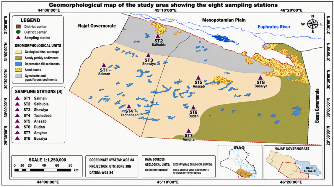
In 2025, a comprehensive series of field investigations was conducted to characterize the geological setting, geomorphology, and surface-sedimentary environments of the Al-Muthana Desert. Eight representative sampling stations were spatially distributed across the study area: St1 (Salman), St2 (Salhubia), St3 (Shawiya), St4 (Tachadeed), St5 (Anssab), St6 (Dudan), St7 (Amghar), and St8 (Busaiya). These stations were strategically selected on the basis of their geographical positions and spatial heterogeneity to represent variations in geological and ecological conditions. Vegetation surveys were conducted using randomly distributed quadrats of appropriate dimensions, within which all vascular plant species were recorded and identified to the species level. The recorded vegetation was classified into life-form categories, and vegetation patterns were evaluated quantitatively in relation to sediment salinity, moisture regime, sediment texture, and depositional characteristics to determine the influence of geological and geomorphological factors on vegetation distribution and community structure (Figure 1). Particular emphasis was placed on the spatial differentiation of local Quaternary depositional environments, including shallow depressions, depression-fill deposits, aeolian dunes, and sand-sheet sediments, which reflect the pronounced geomorphological variability of the study area [5].
Plant samples were collected from eight locations in the Al-Muthana Desert during the peak flowering and fruiting period through six field trips conducted from February to May 2025. Sampling was undertaken to document the regional flora during its principal flowering season. To capture variation in vegetation composition and habitat heterogeneity, major environmental gradients, particularly soil salinity and moisture availability, were examined using a stratified ecological sampling design. The eight representative stations encompassed several ecological zones within the study area, including a central saline basin, moist peripheral margins, transitional zones, and the outer desert. Collected specimens were processed, preserved, and curated at the Herbarium of the Iraq Natural History Research Center and Museum. Taxonomic identification and family-level verification were performed in the Plant and Environment Laboratory of the same institution using standard floristic and taxonomic references to ensure nomenclatural accuracy and scientific reliability [13-15]. To ensure methodological reproducibility and valid comparisons among stations, the vegetation-sampling protocol was standardized across all field surveys in the Al-Muthana Desert. Herbaceous vegetation was assessed using 1 × 1 m quadrats, whereas 5 × 5 m quadrats were used for shrub-dominated stands, depending on habitat structure. Quadrats were randomly positioned at each of the eight sampling stations (St1-St8). At each station, 10 quadrats were established with a minimum spacing of 20 m to reduce spatial autocorrelation and ensure the independence of sampling units. Six consecutive field trips were conducted between February and May 2025, the peak flowering and fruiting period of desert flora. In each quadrat, all vascular plant species were identified and recorded. Abundance was quantified by direct counts for annual and tufted species and by visual estimates of percentage cover for shrubs and clonal taxa using the Braun-Blanquet cover-abundance method. A handheld GPS receiver was used to record the geographical coordinates of all stations. A sampling-design table summarizing station location, geomorphological type, number of quadrats, survey date, and measured ecological variables was prepared to facilitate reproducibility in subsequent ecological and biogeographical studies.
Statistical analysis. A robust multivariate ecological analysis was conducted to quantify spatial heterogeneity and compositional relationships among the investigated vegetation stations using standardized phytodiversity descriptors: species richness (S), the Shannon-Wiener diversity index (H′), the Simpson diversity index (1-D), Pielou's evenness index (J), and the dominance index (D). Before analysis, the ecological variables were standardized as z-scores to minimize dimensional bias and ensure that all variables contributed equally to the ordination. Euclidean distances between stations were calculated using the generalized distance function $D(x, y)=\sqrt{\sum_{i=1}^n\left(x_i-y_i\right)^2}$, where xi and yi represent the ecological attributes of each station. Principal component analysis (PCA) was then performed on the standardized variables to reduce multidimensional ecological variation to a small number of orthogonal principal components explaining the maximum proportion of total variance.
This analysis provided an ordination framework for identifying ecological gradients and groups of stations with similar vegetation assemblages.
To assess habitat-differentiation patterns in the study area, Euclidean distances among vegetation-sampling stations were calculated using species richness, the Shannon diversity index (H′), and the Simpson diversity index (1-D). Before analysis, the variables were standardized to eliminate differences in measurement scales and ensure equal contributions to the distance calculations. The Euclidean distance matrix and PCA were computed using International Business Machines Corporation (IBM) Statistical Package for the Social Sciences (SPSS) Statistics, version 27.0. The ordination results aided interpretation of community-level responses to environmental heterogeneity, habitat stability, dominance structure, and diversity partitioning; when interpreted together, these results clarified floristic organization and ecological connectivity among the study stations. The observed vegetation patterns were plausibly associated with salinity, moisture availability, gypsum buildup, and sediment texture, which are recognized as major ecological drivers in arid desert ecosystems. However, because station-level physicochemical measurements were unavailable, causal relationships remain uncertain, and the findings should be regarded as plausible ecological interpretations. Future studies should include sediment analyses to quantify the effects of these environmental factors on plant species.
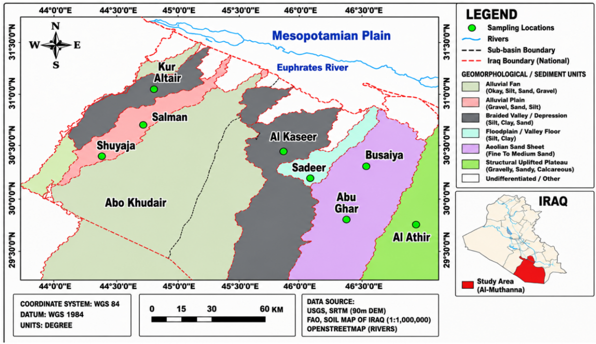
The study area is located in the Al-Muthana Desert in the southern part of the Iraqi Western Plateau, between 29°45′-31°30′ N and 44°00′-46°30′ E. It covers approximately 44,914 km² (86.9% of the governorate's area). Geological evidence indicates that the area is dominated by Tertiary sedimentary successions, particularly the Umm Er Radhuma, Dammam, Ghar, Euphrates, Nfayil, and Dibdibba formations. These successions consist mainly of dolomitic limestone, chalky dolomite, anhydrite, chert, and interbedded clay horizons containing fossiliferous beds and flint. The formations are overlain by widespread Pleistocene and Holocene deposits, including alluvial-plain sediments, inland sabkha deposits, depression-fill accumulations, and aeolian sands composed mainly of loose gravel, sand, silt, and clay. The study area forms part of the Najd-Hejaz and Western Plateau physiographic units. The terrain is generally flat to gently undulating, with elevations ranging from approximately 10 to 435 m above sea level and a regional slope from south to north. The major wadis-Kur Al-Tair, Shuyaia, Abu Khudair, Al-Kuseer, Sadeer, Abu Ghar, and Al-Athir-shape the geomorphology by influencing sediment transport, surface drainage, and landscape evolution through surface-water and groundwater flow.
The sediments of the Al-Muthana Desert are generally shallow, stony, and weakly developed, with low organic-matter content and abundant gypsum (CaSO4), reflecting intense evaporation under arid climatic conditions. Based on geomorphological origin and topographic setting, the desert sediments can be broadly classified into three categories: deposits associated with depressions and valley systems; sediments transported and redistributed by episodic floodwaters and rainfall runoff along the main valley systems; and aeolian sediments formed primarily by wind action. These deposits consist mainly of gravel, sand, gypsum, calcareous material, and varying proportions of silt and clay. The southern sector of the desert contains extensive stony desert pavements composed of coarse sandy and sandstone-derived materials, with sediment thicknesses generally below 10 cm. Much of the natural desert also contains widespread aeolian dune deposits, particularly in the northern and northeastern sectors. In addition, a relatively continuous linear belt of sandy-gravelly desert sediments extends along the eastern margin of the study area adjacent to Basra Governorate. Owing to their loose texture and weak structure, these sediments are readily eroded by wind and water (Figure 2).
Figure 2. Geographical and physiographic setting of the study area (modified after Hussein, 2022)
Field investigations identified distinct Quaternary sedimentary facies across the study area, reflecting different depositional environments and geomorphological processes:
1. Gypcrete and gypsiferous sediments constitute one of the dominant Quaternary depositional facies in the Al-Muthana Desert. They consist of varying mixtures of sand, silt, clay, and secondary gypsum. Under arid to hyper-arid conditions, these deposits form where winter precipitation combines with limited surface drainage. Rainwater accumulates in low-lying, flat, closed depressions, causing temporary inundation. Subsequent intense evaporation precipitates and concentrates soluble salts, producing extensive saline sabkha environments and evaporite crusts. Sabkha-fill sediments consist mainly of unconsolidated sand, silt, and clay in varying textural proportions, commonly accompanied by gypsum and other evaporitic minerals. These depositional environments reflect hydrological fluctuations, evaporative-concentration processes, and aeolian reworking and constitute important geomorphological and pedological components of the desert. Iraq includes different tectonic zones and physiographic provinces; accordingly, different soil types and erosion processes of varying intensity occur across the country [16].
2. In the Al-Muthana Desert, depression-fill deposits occur as fine Quaternary sedimentary accumulations in spatially variable, shallow topographic depressions, typically less than 1 m deep, that sporadically store rainwater during ephemeral flooding. These depositional settings act as temporary hydrological sinks in which runoff-derived material accumulates progressively under low-energy conditions. The fills are dominated by heterogeneous mixtures of clay, silt, and sand, reflecting intermittent sediment supply and varying degrees of transport controlled by surface runoff and sheet floods. Such deposits provide evidence of intermittent stream-related activity and localized soil formation within the desert [17].
3. Aeolian deposits constitute a prominent Quaternary sedimentary facies in the Al-Muthana Desert. In their simplest form, dune deposits occur as extensive sand sheets in areas with limited water availability, whereas more fully developed dune systems occur elsewhere, reflecting spatial variations in wind energy and sediment availability. Depending on the form and scale of sand trapping, sediment thickness ranges from approximately 1 m in sheet-like accumulations to about 5 m in dune complexes. The deposits consist mainly of fine- to medium-grained, quartz-rich, well-sorted sand forming wave-like ridges and mound structures. These features indicate active and sustained aeolian processes under arid climatic conditions.
4. Sandy-pebbly sediments are widely distributed in southern Iraq, particularly in the Amghar area, and constitute an important clastic unit within the sedimentary framework of the Al-Muthana Desert. Most of these deposits are derived from the Dibdibba Formation and include detrital material transported northeastward from the Arabian Shield by fluvial systems. The sediments accumulated in high-energy fluvial environments during the Late Miocene-Pleistocene, indicating sustained sediment supply and active channels. Lithologically, they consist of poorly to moderately sorted sand and pebbles.
The sequence developed under fluctuating paleoclimatic conditions, alternating between semi-humid phases and prolonged arid intervals that collectively controlled sediment transport, deposition, and post-depositional reworking; this interpretation is consistent with the study [18].
The floristic composition of the Al-Muthana Desert revealed a highly specialized xerophytic and halophytic vegetation assemblage adapted to the extreme arid conditions of southern Iraq. A wide range of plant taxa belonging to multiple angiosperm families was recorded across the eight stations, with a clear dominance of drought- and salinity-tolerant species. The family-level composition was primarily represented by Amaranthaceae, Asteraceae, Fabaceae, and Poaceae, which collectively form the characteristic floristic core of desert ecosystems in Southwest Asia. Species such as Haloxylon salicornicum, Artemisia herba-alba, Capparis spinosa, Teucrium polium, and Plantago ovata exhibited broad ecological amplitudes and occurred at several stations. The high frequency of perennial shrubs, dwarf shrubs, and annual herbs reflects common desert adaptations: perennial woody species stabilize habitats, whereas annual therophytes exploit short favorable periods following rainfall. Halophytic species, including Suaeda aegyptiaca, Halopeplis perfoliata, and Zygophyllum qatarense, were associated with the effects of soil salinity and evaporative stress on vegetation structure, particularly in low-lying depressions and saline habitats. Similarly, the continued presence of grasses such as Stipagrostis plumosa and Desmostachya bipinnata highlights the importance of sandy and stabilized sandy substrates. Overall, the floristic composition indicates that the vegetation of the Al-Muthana Desert represents a structurally resilient ecosystem that is ecologically well adapted, functionally diverse, and highly xeromorphic under hyper-arid environmental conditions (Table 1). Plant biodiversity in terrestrial ecosystems is dynamic rather than static over time. Such dynamics may cause the decline or local extinction of certain species, the expansion and increased dominance of others, or the establishment of newly introduced and naturally colonizing species [19].
Table 1. Floristic composition of the study area
|
Family |
Species |
Life Form |
Stations |
|
Amaranthaceae |
Atriplex belangeri (Moq.) Moq. |
annual subshrub |
St1, St8 |
|
Atriplex repens Roth |
perennial subshrub |
St1, St8 |
|
|
Halopeplis perfoliata (Forssk.) Schweinf. & Asch. |
succulent subshrub |
St5 |
|
|
Haloxylon ammodendron (C.A.Mey.) Bunge ex Fenzl |
perennial desert shrub |
St2, St8 |
|
|
Haloxylon salicornicum (Moq.) Bunge ex Boiss. |
perennial dwarf shrub |
St1, St2, St8 |
|
|
Salsola tragus L. |
annual herb |
St4, St7 |
|
|
Caroxylon jordanicola (Eig) Akhani & Roalson |
annual herb |
St4, St5 |
|
|
Suaeda acuminata (C.A.Mey.) Moq. |
annual herb |
St7 |
|
|
Suaeda aegyptiaca (Hasselq.) Zohary |
annual herb |
St1, St3, St5 |
|
|
Suaeda vermiculata Forssk. ex J.F.Gmel. |
annual herb |
St6 |
|
|
Amaryllidaceae |
Allium schoenoprasum L. |
perennial herb |
St2, St3, St8 |
|
Asparagaceae |
Drimia maritima (L.) Stearn |
perennial bulbous herb |
St5 |
|
Asteraceae |
Achillea tenuifolia Lam. |
perennial herb |
St1, St3, St4, St7 |
|
Artemisia herba-alba Asso |
perennial dwarf shrub |
St1, St2, St3, St4, St7 |
|
|
Artemisia pontica L. |
perennial herb |
St4 |
|
|
Cousinia pestalozzae Boiss. |
perennial herb |
St3 |
|
|
Launaea capitata (Spreng.) Dandy |
perennial herb |
St2 |
|
|
Matricaria chamomilla L. |
annual herb |
St7 |
|
|
Micropus supinus L. |
annual herb |
St1 |
|
|
Reichardia tingitana (L.) Roth |
annual herb |
St 8 |
|
|
Rhanterium epapposum Oliv. |
perennial shrub |
St5, St7, St8 |
|
|
Tragopogon porrifolius L. |
biennial herb |
St2 |
|
|
Boraginaceae |
Anchusa azurea Mill. |
perennial herb |
St5 |
|
Arnebia decumbens (Vent.) Coss. & Kralik |
annual herb |
St2, St4, St8 |
|
|
Heliotropium bacciferum Forssk. |
perennial subshrub |
St1 |
|
|
Brassicaceae |
Alyssum turkestanicum Regel & Schmalh. |
annual herb |
St5 |
|
Eremobium aegyptiacum (Spreng.) Asch. |
annual herb |
St3 |
|
|
Eruca vesicaria (L.) Cav. |
annual herb |
St8 |
|
|
Isatis tinctoria L. |
biennial herb |
St7 |
|
|
Neotorularia torulosa (Desf.) Hedge & J.Léonard |
annual herb |
St6 |
|
|
Schouwia purpurea (Forssk.) Schweinf. |
annual herb |
St1 |
|
|
Capparaceae |
Capparis spinosa L. |
perennial shrub |
St1, St2, St3, St5, St8 |
|
Caprifoliaceae |
Pterocephalus brevis Coult. |
annual herb |
St3 |
|
Pterocephalus arabicus Boiss. |
perennial herb |
St4 |
|
|
Caryophyllaceae |
Herniaria hirsuta L. |
perennial herb |
St1 |
|
Spergularia bocconei (Scheele) Graebn. |
annual herb |
St4 |
|
|
Cistaceae |
Helianthemum salicifolium (L.) Mill. |
annual herb |
St7 |
|
Crassulaceae |
Kalanchoe gastonis-bonnieri Raym.-Hamet & H.Perrier |
succulent perennial herb |
St8 |
|
Cucurbitaceae |
Citrullus colocynthis (L.) Schrad. |
perennial creeping herb |
St1, St2, St4, St8 |
|
Ephedraceae |
Ephedra alata Decne. |
perennial shrub |
St7, St8 |
|
Fabaceae |
Alhagi maurorum Medik. |
perennial shrub |
St6 |
|
Astragalus spinosus (Forssk.) Muschl. |
spiny shrub |
St1, St2, St8 |
|
|
Prosopis farcta (Banks & Sol.) J.F.Macbr. |
perennial shrub |
St4 |
|
|
Tephrosia nubica (Boiss.) Baker |
perennial herb/shrub |
St3 |
|
|
Trifolium resupinatum L. |
annual herb |
St5, St7 |
|
|
Trigonella foenum-graecum L. |
annual herb |
St6 |
|
|
Lamiaceae |
Teucrium polium L. |
perennial subshrub |
St1, St2, St4, St8 |
|
Thymus bovei Benth. |
perennial shrub |
St1, St2 |
|
|
Malvaceae |
Malva arborea (L.) Webb & Berthel. |
perennial herb |
St2, St4 |
|
Malva parviflora L. |
annual herb |
St1, St4, St7 |
|
|
Orobanchaceae |
Cistanche tubulosa (Schenk) Wight |
perennial herb |
St1, St8 |
|
Papaveraceae |
Roemeria hybrida (L.) DC. |
annual herb |
St6 |
|
Plantaginaceae |
Plantago ovata Forssk. |
annual herb |
St1, St2, St3, St4, St5, St6, St8 |
|
Poaceae |
Aegilops kotschyi Boiss. |
annual grass |
St4 |
|
Cynodon dactylon (L.) Pers. |
perennial grass |
St3 |
|
|
Desmostachya bipinnata (L.) Stapf |
perennial grass |
St4 |
|
|
Hordeum spontaneum K.Koch |
annual grass |
St2, St8 |
|
|
Hordeum vulgare L. |
annual grass |
St5 |
|
|
Poa annua L. |
annual grass |
St3 |
|
|
Poa bulbosa L. |
perennial grass |
St2 |
|
|
Stipa dregeana Steud. |
perennial grass |
St6 |
|
|
Stipagrostis plumosa (L.) Munro ex T.Anderson |
perennial grass |
St1, St8 |
|
|
Triticum aestivum L. |
annual grass |
St4, St8 |
|
|
Polygonaceae |
Calligonum comosum L'Hér. |
perennial shrub |
St7 |
|
Rumex vesicarius L. |
annual herb |
St3, St6 |
|
|
Rhamnaceae |
Ziziphus nummularia (Burm.f.) Wight & Arn. |
perennial shrub |
St6, St8 |
|
Ziziphus spina-christi (L.) Desf. |
tree |
St6, St8 |
|
|
Solanaceae |
Lycium barbarum L. |
perennial shrub |
St1, St8 |
|
Lycium shawii Roem. & Schult. |
perennial shrub |
St3, St8 |
|
|
Tamaricaceae |
Tamarix aphylla (L.) H.Karst. |
tree |
St3, St5, St7 |
|
Tamarix aucheriana (Decne. ex Walp.) B.R.Baum |
perennial shrub |
St2, St4 |
|
|
Tamarix ramosissima Ledeb. |
perennial shrub |
St2, St5 |
|
|
Urticaceae |
Urtica dioica L. |
perennial herb |
St3, St6 |
|
Urtica urens L. |
annual herb |
St4, St7 |
|
|
Tetradiclidaceae |
Peganum harmala L. |
perennial herb |
St1, St3, St4, St6 |
|
Zygophyllaceae |
Tribulus terrestris L. |
annual herb |
St2, St6 |
|
Zygophyllum qatarense Hadidi |
perennial shrub |
St3 |
Table 2. Geological units and plant species recorded at the investigated stations in the study area
|
Stations |
Geological Unit / Sediment Type |
Species Richness (S) |
Species Characteristics |
|
St1 |
Depression-fill clastic deposits |
18 |
Mixed shrub–herb community |
|
St2 |
Depression-fill clastic deposits |
16 |
Shrub–grass association |
|
St3 |
Gypcrete and gypsiferous sandy–silty deposits |
14 |
Gypsum-tolerant flora |
|
St4 |
Aeolian deposits and sand dunes |
17 |
Sparse psammophytic vegetation |
|
St5 |
Aeolian deposits and sand dunes |
15 |
Discontinuous dune vegetation |
|
St6 |
Gypcrete and gypsiferous sandy–silty deposits |
12 |
Halophytic–gypsophytic assemblage |
|
St7 |
Dibdibba Formation (sandy–pebbly deposits) |
13 |
Xerophytic shrub–grass community |
|
St8 |
Depression-fill clastic deposits |
23 |
Mixed desert assemblage dominated by shrubs, perennial grasses, and halophytic species |
Geological substrates and sediment characteristics strongly control plant distribution in the Al-Muthana Desert. The highest species richness was recorded at stations situated on depression-fill clastic deposits (St1, St2, and St8). By contrast, gypsiferous and gypcrete deposits (St3 and St6) were characterized by low species richness and were dominated by halophytic and gypsophytic species because of the restrictive properties of gypsum-rich soils. Likewise, aeolian deposits and dunes (St4 and St5) supported sparse, discontinuous vegetation owing to substrate instability and low water-holding capacity. At St7, coarse sandy-pebbly sediments supported a xerophytic shrub-grass community adapted to arid conditions. These results demonstrate that geological heterogeneity exerts major control over vegetation composition and diversity in the Al-Muthana Desert. Depression-fill deposits provided the most favorable habitats and supported relatively high vegetation cover (Table 2).
The analysis showed that vegetation structure varied markedly among desert stations owing to differences in microhabitats and edaphic conditions.
Species richness was 13 at both St5 and St6 and reached a maximum of 24 at St8, indicating substantial differences in habitat suitability and ecological stability among sites. St8 also had the highest Shannon diversity value (H′ = 2.880), followed by St4 (H′ = 2.840). The dominance index was lowest at St8 (D = 0.056), indicating a highly diverse and structurally balanced plant community with limited competitive exclusion.
Conversely, diversity values were lower at St5 (H′ = 2.420) and St6 (H′ = 2.370) under harsher environmental conditions, including elevated soil salinity, gypsum accumulation, moisture scarcity, and substrate instability, which characterize arid desert ecosystems. Simpson diversity values remained consistently high (0.894-0.944) across all stations, indicating moderate to high floristic complexity without extreme monospecific dominance. Likewise, the high evenness values (J = 0.890-0.965) indicate that individuals were distributed relatively evenly among species despite differences in species richness, suggesting stable coexistence between xerophytic and halophytic taxa. The dominance of perennial shrubs and subshrubs, primarily from Amaranthaceae, Asteraceae, Poaceae, and Tamaricaceae, further indicates that drought-tolerant, salt-resistant, deep-rooted polycarpic species can withstand the harsh environmental conditions of the desert. Overall, the observed diversity gradients indicate that local environmental filtering and topographic-edaphic heterogeneity play key roles in determining floristic composition and community organization in the studied desert ecosystem (Table 3).
Table 3. Diversity indices of vegetation communities across the studied stations
|
Stations |
Species Richness (S) |
Shannon Diversity Index (H′) |
Simpson Index (1−D) |
Evenness (J) |
Dominance Index (D) |
|
St1 |
21 |
2.710 |
0.92 |
0.890 |
0.074 |
|
St2 |
19 |
2.760 |
0.934 |
0.937 |
0.066 |
|
St3 |
18 |
2.790 |
0.938 |
0.965 |
0.062 |
|
St4 |
20 |
2.840 |
0.942 |
0.948 |
0.058 |
|
St5 |
13 |
2.420 |
0.901 |
0.944 |
0.099 |
|
St6 |
13 |
2.370 |
0.894 |
0.924 |
0.106 |
|
St7 |
14 |
2.450 |
0.907 |
0.928 |
0.093 |
|
St8 |
24 |
2.880 |
0.944 |
0.906 |
0.056 |
Table 4. Euclidean distance matrix among vegetation-sampling stations in the study area
|
Stations |
St1 |
St2 |
St3 |
St4 |
St5 |
St6 |
St7 |
St8 |
|
St1 |
0.000 |
0.729 |
1.103 |
1.129 |
2.922 |
3.249 |
2.506 |
1.534 |
|
St2 |
0.729 |
0.000 |
0.375 |
0.655 |
2.967 |
3.360 |
2.542 |
1.554 |
|
St3 |
1.103 |
0.375 |
0.000 |
0.626 |
3.072 |
3.488 |
2.654 |
1.679 |
|
St4 |
1.129 |
0.655 |
0.626 |
0.000 |
3.617 |
4.013 |
3.192 |
1.079 |
|
St5 |
2.922 |
2.967 |
3.072 |
3.617 |
0.000 |
0.459 |
0.446 |
4.417 |
|
St6 |
3.249 |
3.360 |
3.488 |
4.013 |
0.459 |
0.000 |
0.858 |
4.767 |
|
St7 |
2.506 |
2.542 |
2.654 |
3.192 |
0.446 |
0.858 |
0.000 |
3.991 |
|
St8 |
1.534 |
1.554 |
1.679 |
1.079 |
4.417 |
4.767 |
3.991 |
0.000 |
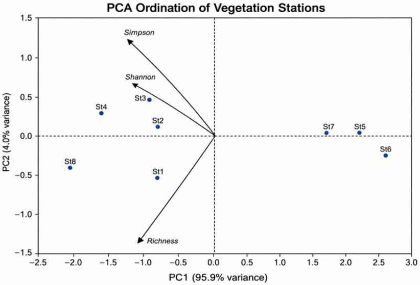
Figure 3. Principal component analysis (PCA) ordination of vegetation stations based on species richness and diversity indices
PCA was performed using standardized ecological variables: species richness, the Shannon diversity index (H′), and the Simpson diversity index (1-D). Variables such as evenness and dominance were excluded because they are mathematically related to the included descriptors, thereby avoiding multicollinearity and non-independence. PCA summarized ecological relationships among stations and visualized the contributions of diversity variables to vegetation differentiation across the study area (Table 4, Figure 3).
The PCA ordination revealed differences among vegetation stations based on species richness and the Shannon and Simpson diversity indices. The first principal component (PC1) explained 95.9% of the variance, indicating that most variation among stations arose from differences in these diversity measures. St5, St6, and St7 had positive PC1 scores, suggesting similar richness and diversity characteristics. Conversely, St2, St3, and St4 plotted closer to the Shannon and Simpson vectors than St1 and St5, indicating more similar diversity profiles and stronger associations with these indices. The proximity of St2 and St3 in both the PCA ordination and the Euclidean distance matrix confirms their similarity. St8 was clearly separated from the other stations, indicating a distinct diversity pattern.
St1 occupied an intermediate position, indicating moderate similarity to the other stations. The Euclidean distance matrix showed varying degrees of similarity among stations. The smallest distance occurred between St2 and St3 (0.375), indicating high similarity in richness and diversity indices. High similarity was also observed between St5 and St7 (0.446) and between St5 and St6 (0.459). By contrast, the greatest distances occurred between St8 and St6 (4.767), followed by St8 and St5 (4.417), indicating marked differences in diversity attributes. Overall, St1-St4 and St5-St7 formed two internally more similar groups, whereas St8 remained distinct from the other stations. The PCA results therefore demonstrate substantial spatial variation among vegetation stations based on richness and diversity indices.
Sampling-site distributions corresponded to sedimentary features, woody-plant composition, soil texture, and geomorphology.
1. The depression-associated clastic sediments at Sites 1, 2, and 8 (Salman, Salhubia, and Busaiya, respectively) supported the highest floristic richness and structural heterogeneity among the investigated sites.
The dominance of xerophytic and halophytic representatives of Amaranthaceae, Asteraceae, Lamiaceae, Asparagaceae, Solanaceae, and Fabaceae constituted the principal adaptive flora of the arid Iraqi desert ecosystem. The presence of Amaryllidaceae, Poaceae, Plantaginaceae, and Cucurbitaceae demonstrated additional ecological heterogeneity and microhabitat variability. These communities likely supported higher species diversity than other desert substrates because of greater water availability, sediment stability, and localized nutrient accumulation.
2. The vegetation assemblages at Sites 3 (Shawiya) and 6 (Dudan) were associated with gypsiferous sandy-silty deposits and gypcrete. These habitats had low vegetation cover and low species diversity. In sabkha-type areas, plants generally occurred in isolated patches separated by barren surfaces because of the harsh conditions imposed by saline-gypsiferous substrates. The floristic composition was simple and dominated by stress-tolerant taxa from Asteraceae, Solanaceae, Amaryllidaceae, Plantaginaceae, Rhamnaceae, Tamaricaceae, and Zygophyllaceae. These families tend to be associated with hypersaline, gypsum-rich habitats subject to severe drought because of their specialized physiological and morphological adaptations.
3. The sandy terrain and dune sites at St4 (Tachadeed) and St5 (Anssab) contained mobile sandy substrates and unstable geomorphological conditions that strongly limited vegetation establishment and persistence. Vegetation was sparse and discontinuous, occurring as isolated individuals or clumps on the more stabilized parts of dunes. Although overall density was low, psammophytic species were well represented. The dominant and floristically important families were Asteraceae, Boraginaceae, Plantaginaceae, and Capparaceae. Taxa inhabiting aeolian environments exhibit several adaptations, including extensive root systems, small leaf areas, pubescence, and tolerance of wind erosion and sand burial, which enable survival in these dynamic environments.
4. At Site 7 (Amghar), the sandy-pebbly deposits of the Dibdibba Formation were associated with low floristic diversity and a simplified community composition because of the coarse texture and low water-holding capacity of the substrate. The Dibdibba sediments are well-drained deposits composed of gravelly sand and pebbly material. Vegetation in this habitat was dominated primarily by Asteraceae and Ephedraceae, reflecting their ecological tolerance of dry, nutrient-poor conditions.
The Al-Muthana Desert ecosystem supports a structurally simple but ecologically specialized vegetation assemblage associated with strong edaphic, hydrological, and climatic gradients characteristic of a saline arid landscape. The vegetation shows clear ecological differentiation among habitats, and its distribution is associated with soil salinity, substrate type, moisture availability, and geomorphological diversity. Similar patterns have been reported in Iraqi desert ecosystems and other arid environments of Southwest Asia [20, 21].
The occurrence of ruderal and disturbance-tolerant species, such as Malva parviflora and Capparis spinosa, indicates localized disturbances, including grazing pressure, sediment displacement, and sporadic human activity. Such species frequently occupy ecologically unstable habitats and can indicate habitat disturbance and transitional environmental conditions. The loss of a plant species or group of species within an ecosystem disrupts its functional integrity [22].
Relationships of geology and geomorphology with plant life forms. The structure and relative abundance of plant life forms in the Al-Muthana Desert are closely associated with geomorphological and sedimentological variation across the study area. Field observations indicated that the desert landscape comprises four principal geomorphic units: depression-fill sediments, gypcrete and gypsiferous deposits, aeolian deposits and dunes, and sandy-pebbly sediments. These geological units create distinct soil conditions that affect plant distribution, vegetation composition, and the abundance of life forms at the investigated sites.
Although several sampling sites shared similar broad geological classifications (e.g., St4-St6), differences in salinity, soil texture, and moisture availability resulted in pronounced variation in floristic composition and vegetation density. This finding indicates that plant distribution in the Al-Muthana Desert is determined not only by geological substrate but also by associated environmental factors, including salt accumulation, soil stability, and water availability. Plant families with broad ecological amplitudes contribute substantially to vegetation and soil stability in moderately disturbed desert habitats [23].
Gypsiferous soils and depression-fill sediments are among the most extensive geomorphological units in the study area; species belonging primarily to Amaranthaceae and Asteraceae were associated with soils containing high gypsum concentrations or fine material derived from aeolian transport, runoff, and erosion of the surrounding uplands.
Moreover, aeolian dune systems predominantly supported taxa from Tamaricaceae, Malvaceae, and Zygophyllaceae. Wind activity creates these geomorphological features through continuous erosion, transport, and deposition. The dominance of these families in dune habitats is associated with their ability to withstand drought stress, sand burial, substrate instability, and low nutrient availability. Several species in these groups possess deep roots, small leaves, and other adaptations that enable persistence in shifting sands [24, 25]. Wild plant species face an increasing risk of extinction as climate change raises temperatures and reduces rainfall, thereby intensifying environmental stress and increasing the vulnerability of natural vegetation.
Variation in the abundance of plant life forms in the Al-Muthana Desert demonstrates that life-form patterns are strongly influenced by geomorphological processes.
The floristic survey of the Al-Muthana Desert recorded 74 species belonging to 27 families, with Amaranthaceae, Asteraceae, and Poaceae as the dominant families. Vegetation diversity varied among stations: species richness ranged from 13 to 24, and the Shannon diversity index ranged from 2.370 to 2.880. St8 exhibited the highest diversity, whereas St5 and St6 had the lowest values. High evenness and low dominance indicated relatively balanced plant communities. Euclidean distance analysis also revealed substantial variation in floristic and diversity attributes among stations. These findings provide a useful basis for future biodiversity assessments and conservation planning in the arid ecosystems of southern Iraq.
[1] Hussein, M.L., Menshed, M.A., Al-Owaidi, M.R.A., Abduula, M.D. (2021). Sedimentological properties of the sand dunes and valley sediments in Al-Muthanna, southern Iraq. The Iraqi Geological Journal, 54(1F): 69-84. https://doi.org/10.46717/igj.54.1F.7ms-2021-06-27
[2] Al-Jayashi, J.W.S. (2019). Geographical analysis of the natural characteristics of the Muthanna Governorate desert and its impact on the country's economic activity. Uruk Journal of Human Sciences, 12(2): 41. https://muthuruk.mu.edu.iq/journal/vol12/iss2/41/.
[3] Al-Joboury, K.R. (2020). Survey of exotic plant species in Iraq. Plant Archives, 20(2): 1236-1237.
[4] Hussein, S. (2022). Characteristics of the water network in the Abu Gwer Basin in the Badia of Muthanna Governorate using RS and GIS techniques. Uruk Journal of Education for Humanities, 15(4): 2773-2786. https://muthuruk.mu.edu.iq/journal/vol15/iss4/1.
[5] Al-Zubaidi, A.A., Mohammad, M.K., Al-Barazanjy, A.N. (2024). The relation between geodiversity and biodiversity of Al-Salman Depression, Al-Muthana Governorate, southern desert of Iraq. The Iraqi Geological Journal, 57(1A): 288-300. https://doi.org/10.46717/igj.57.1A.20ms-2024-1-31
[6] Al-Khafaji, S.N. (2025). Morphotectonic processes in the Al-Muthana Governorate desert and their risks based on geographic information systems. Al-Qadisiyah Journal for Humanities Sciences, 28(3): 287-314.
[7] International Organization for Migration (IOM). (2026). The Interaction Between Climate Change, Biodiversity Loss and Human Mobility in Iraq. International Organization for Migration, Baghdad. https://iraq.iom.int/resources/interaction-between-climate-change-biodiversity-loss-and-human-mobility-iraq.
[8] Al-Ashbal, H.N., Al-Joboury, K.R., Jalil, S.J. (2025). Insects infestation for plants of Fabaceae in different areas in Iraq. IOP Conference Series: Earth and Environmental Science, 1449(1): 012057. https://doi.org/10.1088/1755-1315/1449/1/012057
[9] Mohammed, S.H., Wheib, K.A. (2024). Micromorphological characterization of salt-affected soils of the Alnajmi Agricultural Project in Muthanna Governorate, southern Iraq. Iraqi Journal of Agricultural Sciences, 55(6): 2074-2084. https://doi.org/10.36103/9k510k55
[10] Khan, M.N., Ali, S., Yaseen, T., et al. (2019). Eco-taxonomic study of family Poaceae (Gramineae). RADS Journal of Biological Research & Applied Sciences, 10(2): 63-75. https://doi.org/10.37962/jbas.v10i2.191
[11] Gomaa, H. (2017). Spatial analysis of medicinal plants in the semi-desert of Samawa and the possibility of investment. Unpublished Ph.D. thesis, Department of Geography, College of Arts, University of Baghdad, Baghdad, Iraq.
[12] Abed, F.H., Al-Khafaji, S.N. (2021). Rainfall and ways of managing and investing: A study in the development of water resources in Muthanna Governorate (Badia Al Samawah). Al-Adab Journal, 137(Suppl. 2): 417-442. https://doi.org/10.31973/aj.v3i137.1403
[13] Al-Joboury, K.R., Wannas, A.K. (2025). Survey of plants for Brenaj, Wasit, Iraq. Journal of Bioscience and Applied Research, 11(4): 1199-1209. https://doi.org/10.21608/jbaar.2025.468379
[14] Othman, O.M., Al-Kasiy, A.M.A., Al-Hazemawi, A.K.H., Shahatha, S.S., Abood, N.M., Mousa, M.O. (2025). Increasing wild plant species in the western desert district of Iraq. Anbar Journal of Agricultural Sciences, 23(1): 596-613. https://doi.org/10.32649/ajas.2025.187543
[15] Al-Joboury, K.R., Al-Dabbas, M.A. (2023). Geological and plant diversity in selected areas of Al Tib, Maysan, Iraq. Revis Bionatura, 8(3): 106. https://doi.org/10.21931/RB/2023.08.03.106
[16] Sissakian, V.K., Othman, A.A., Obaid, A.K., Abdulhaq, H.A. (2025). Soil types and erosion in Iraq: A critical discussion. Iraqi Bulletin of Geology and Mining, 21(1): 343-364. https://doi.org/10.59150/ibgm2101a19
[17] Al-Sudani, H.I.Z. (2025). Groundwater resources in Muthanna Governorate, south of Iraq. Resources Environment and Information Engineering, 6(1): 340-353. https://doi.org/10.25082/REIE.2025.01.002
[18] Al-Aajibi, M.J., Al-Jiashi, J.W. (2021). Optimal use of natural resources in the Al-Muthanna Desert: Soil as a model. IOP Conference Series: Earth and Environmental Science, 923(1): 012078. https://doi.org/10.1088/1755-1315/923/1/012078
[19] Mousa, M.O., Shahatha, S.S., AlFahdawy, H.S.M., Abood, N.M., Mukhlif, F.H. (2024). Identifying and check names of wild plants from Brassicaceae family in western desert district of Iraq. IOP Conference Series: Earth and Environmental Science, 1325(1): 012047. https://doi.org/10.1088/1755-1315/1325/1/012047
[20] Waheed, H.K., Abboud, A.S. (2018). The importance of medicinal plants and their uses in ancient civilizations. Al-Adab Journal, 1(123): 377-392. https://doi.org/10.31973/aj.v1i123.154
[21] Maaroof, B.F. (2021). Geographical assessment of natural resources in the Abu-Hadair drainage basin, Al-Salman Desert, southern Iraq. Indian Journal of Ecology, 48(3): 797-802. https://systems.uomisan.edu.iq/cv/uploads/files/8jios_rpq9adlnf.pdf.
[22] Al-Knaany, S.A., Al-Asadi, W.M.T., Adlan, N.H., Obaid, A.A.H. (2026). Biodiversity study of the southern desert of Basrah Governorate. Pakistan Journal of Botany, 58(5): 1143-1151. https://doi.org/10.30848/PJB2026-5(2)
[23] Ma, H., Sheng, T., Ma, Y., Gou, J. (2024). An improved Ningxia desert herbaceous-plant classification algorithm based on YOLOv8. Sensors, 24(12): 3834. https://doi.org/10.3390/s24123834
[24] Tuaih, H.F., Al-Asadi, W.M.T. (2023). Effect of some environmental factors on the distribution and spread of Artemisia scoparia Waldst. et Kit. in Basrah Governorate. Earth and Environmental Science, 1262(2): 022015. https://doi.org/10.1088/1755-1315/1262/2/022015
[25] Al-Joboury, K.R. (2020). Taxonomic study of Volkameria inermis L. (Lamiaceae). Plant Archives, 20(1): 2550-2552.