Ali Hameed Al-Obaidy* | Husam Sachit Senah
© 2026 The authors. This article is published by IIETA and is licensed under the CC BY 4.0 license (http://creativecommons.org/licenses/by/4.0/).
OPEN ACCESS
Urban cohesion remains a challenge in historic cities where functional fragmentation disrupts walkability. This study investigates how functional diversity contributes to urban cohesion in the historic city of Kufa. Existing studies often rely on descriptive land-use classifications that fail to quantify spatial performance. This research proposes a spatial analytical framework combining activity density mapping, the entropy-based land-use mix index, and pedestrian accessibility indicators. Land-use and road-network data were obtained from master plans and the municipal Geographic Information Systems (GIS) database and validated through geo-referencing, topology checks, and field surveys. A correlation analysis was performed to evaluate the relationship between functional diversity and network connectivity. Results indicate a spatial imbalance, with the historic core showing higher functional diversity and pedestrian accessibility than peripheral districts. Statistical findings reveal a significant positive correlation (r = 0.94, p < 0.001) between functional diversity and network connectivity. Vacant urban spaces provide opportunities for mixed-use development that enhances functional diversity and urban cohesion while preserving the cultural significance of Kufa Mosque. Improving permeability and walkability through the rehabilitation of archaeological sites surrounding Kufa and Sahla Mosques may strengthen spatial connectivity and promote urban cohesion. The study proposes a transferable framework for assessing historic cities and highlights mosque-oriented cultural values supporting urban development in Kufa.
urban cohesion, functional diversity, land use mix, spatial analytical framework, metric-driven urban assessment, historic cities, Kufa
Cities in today's world are experiencing rapid urban and social change and, as such, are facing increased difficulties due to spatial fragmentation and loss of urban cohesion. Because of this, many professionals in the fields of urban planning and design have started to develop principles to design cities that foster social interaction, inclusivity (i.e., all populations are welcomed), and continuity (i.e., reinforcing the sense of community) in the urban form while promoting the protection of cultural and historical identity. In this dialogue, the role of functional diversity (i.e., having multiple uses in a given area) has become an important spatial strategy related to creating urban vitality and socio-spatial integration [1].
In the theoretical foundation of functional diversity, Jane Jacobs strongly emphasizes that if different urban functions coexist, they create continuous activity patterns or 'rhythms' that enliven an urban area [2]. The coexistence of multiple urban functions can increase street-life intensity and encourage interaction among users. It creates spatial and temporal overlap in their daily activities. Functional diversity has substantial theoretical support from Jacobs and other theorists. Yet its measurement as a spatial variable remains methodologically unresolved [3]. This limitation is especially relevant in historic religious cities such as Karbala, where sacred centrality shapes urban morphology, land use, and daily practices [4].
Under the influence of modernization, many historic cities are becoming less balanced in their use of space. This has led to an increase in spatial separation between people and a decline in the sense of community among those who used to have close ties to one another [5]. Most studies that attempt to address these changes do so through descriptive methods with little to no quantitative data regarding the relationships between land uses and community cohesion [6]. As such, there is a significant lack of research on these topics in historic Middle Eastern cities, such as Kufa, Iraq [7]. In response to the identified void, this study formulates an analytical framework based upon Geographic Information Systems (GIS) that allows for the application of spatial metrics to quantify functional diversity and measure its effect on urban cohesion. Land-use data were obtained from historical base maps and master plans for Kufa. An official 2025 GIS database was jointly provided by the Kufa Municipality Directorate, Najaf Directorate of Physical Planning, and Iraqi Ministry of Municipalities and Public Works. Land-use and road-network datasets were standardized, georeferenced, and validated through topology checks and field surveys to ensure accuracy and reliability. Land-use classification followed the official municipal categories adopted in the Kufa master plan. Spatial analyses, including Kernel Density Estimation (KDE) and Entropy-based land use mix (LUM), were conducted using GIS, while street-network connectivity was analyzed in Quantum Geographic Information System (QGIS) based on Space Syntax methodology, using, in some cases, an analysis radius of 1300 m, 500 m, and 150 m from the boundary of Kufa Mosque as a center for the city. In addition, Landsat 7 and Landsat 8 imagery were processed to support spatial interpretation and mapping. All analyses were conducted using the administrative boundary of Kufa City as the primary spatial unit of analysis. All maps were validated through geo-referencing, topology checks, and field surveys.
The study transforms theoretical principles into measurable indicators, facilitating an evidence-based understanding of the relationship between functional configuration and both the structural and social cohesion of historic cities, while contributing a model for cohesive urban regeneration. Despite increasing interest in functional diversity and urban cohesion, quantitative assessments in historic cities remain limited, particularly regarding the integration of land-use entropy measures, pedestrian accessibility based on network distance, spatial distribution of activity density, and public-space connectivity, blocks permeability metrics. Most existing studies rely on descriptive land-use classifications without systematically capturing spatial performance or linking functional mix to accessibility and urban cohesion outcomes. In this context, the historic city of Kufa represents a representative case due to its strong religious centrality, compact historic core, and rapidly expanding peripheral districts, which together create a clear spatial contrast between highly accessible and poorly accessible urban environments. Accordingly, the study addresses how functional diversity varies across historic and peripheral areas of Kufa, how functional diversity contributes to urban cohesion indicators, and how integrated spatial metrics can support the planning and conservation of cohesive historic urban environments.
The goal of this research is to operationalize urban cohesion as a measurable spatial condition through a new integrated quantitative framework utilizing GIS-based spatial metrics, configurational network analysis, and statistical validation. As part of this framework, functional diversity will be considered a key spatial driver affecting structural integration and pedestrian continuity within historical urban environments. As part of this study, the urban structure of Kufa was digitized into standardized spatial units, allowing for the conversion of functional distributions into quantifiable indicators. To assess functional diversity, an Entropy-based LUM index was created using Activity Density Mapping to capture variations in spatial grain and intensity of function. Using the results above, a space analysis was conducted to compute both spatial integration and configurational accessibility through the evaluation of how street morphology affects movement potential. A comparative morphological assessment identified discrepancies in the spatial characteristics between the historic core of Kufa and its peripheral district. Finally, statistical correlation analysis validated the relationships between functional diversity, activity concentration, and accessibility performance, redefining urban cohesion as an empirically observable spatial phenomenon. The resulting workflow establishes a transferable analytical model for evaluating functional performance and spatial resilience in historic Middle Eastern cities.
The street network was derived from the official Master Plan and GIS database provided by the Kufa Municipality Directorate. Field observations and on-site measurements verified its consistency with the existing urban structure. Duplicate segments were removed, disconnected links were corrected, and topological consistency was verified to produce a continuous network. The processed network was analyzed using the Arc Geographic Information System (ArcGIS) Network Analyst extension to derive connectivity indicators for the configurational assessment, as illustrated in the research methodology flowchart (Figure 1).
The analysis adopted a segment-based approach using discrete street segments rather than axial lines. This method evaluates connectivity and accessibility at the street-segment level and is suited to the irregular morphology of historic Kufa. Street classifications from the municipal GIS database were retained to preserve the functional hierarchy of the network. Primary, secondary, and local streets formed a unified pedestrian network without weighting factors. Accessibility was therefore evaluated from network configuration rather than roadway capacity.
Network accessibility was assessed using three thresholds centred on Kufa Mosque. The 150 m radius represents the immediate pedestrian environment around the mosque. The 500 m radius defines the corridor linking Kufa Mosque and Al-Sahla Mosque within the historic core. The 1300 m radius covers the wider urban area, connecting the historic centre with surrounding residential districts and the riverfront. These thresholds capture the hierarchical spatial structure of Kufa and support a multi-scale assessment of accessibility and urban cohesion.
The existing body of urban design literature consistently identifies functional diversity as a central determinant of urban vitality and socio-spatial integration. Pinto and Remesar [8] demonstrated through comparative analysis across central, peripheral, and semi-urban typologies that multi-functional environments generate stronger urban identity and higher levels of social interaction than mono-functional areas. By reducing spatial separation between residential, professional, and service-related uses, functional diversity promotes walkability and active mobility patterns, reinforcing its role as a structural component of sustainable urban environments. In contrast, single-use districts, particularly residential suburbs, often experience reduced public space activity and weakened urban cohesion.
By increasing the size dimension in their research on the historic city of Kerman, study [9] has found a direct correlation between LUM and the degree of interaction among people within that area. The relative diversity of land use and the degree to which habitation and economic activities are co-located were shown by GIS-based indicators and methods. The results demonstrate that historical centralized cores and their associated areas demonstrate a continuance of urban vitality because of the overlapping of multiple uses of land in a concentrated manner. Furthermore, the result confirms that being close to multifunctional hubs enhances functional interconnectedness and increases the overall cohesiveness of all areas in cities. Overall, these findings indicate that concentrated land-use diversity supports social interaction, urban vitality, and spatial cohesion in historic city centers.
Cervero and Kockelman [10] introduced the '3Ds' (density, diversity, and design) framework as a model demonstrating how highly compact, diverse urban structures have an impact on reducing the need for motor vehicle use. They also found that diversity is not only a morphological attribute of the urban structure but also a determining factor in travel behavior and accessibility patterns. Many researchers agree that functional diversity positively impacts urban vitality; however, there are still serious methodological issues regarding how to study this correlation. Most published research treats diversity as an outcome of design instead of a measurable analytical variable used to explain urban cohesion. Furthermore, there is limited research connecting spatial metrics, including the Entropy Index (ENT), with quantitative applications in historically Middle Eastern contexts. Addressing this gap, the present study develops a GIS-based methodological framework that evaluates how functional configuration directly influences the structural cohesion of the historic city of Kufa.
4.1 Conceptualizing urban diversity
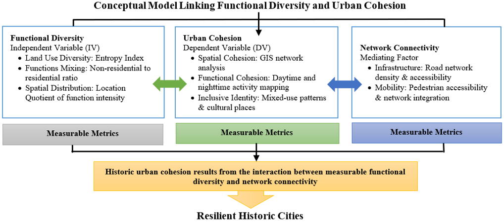
The concept of diversity has been widely used in recent years and has many definitions depending on the context. However, in the context of this study, diversity refers to the multiplicity of demographic, cultural, economic, and urban characteristics within cities. This includes differences in ethnicity, cultures, lifestyles, income levels, land uses, and economic activities. This diversity is a fundamental characteristic of modern cities and an important element in enhancing their vitality and sustainability (United Nations Human Settlements Program - UN-Habitat). Successful urban areas can be distinguished from others through the movement of residents and the use of different activities throughout the day and night. The mix of uses is key to the success of urban areas. Diversity requires a broad mix of uses, which in turn depends on adequate levels of all activities, including flexibility of movement with easy access to all uses and public spaces that allow for interaction among residents, Figure 2 summarizes these dimensions and relationships.
Public facilities and services should be located close to each other, increasing the mixing of land uses that are compatible with other uses and accessible by walking or cycling. To achieve urban character, cities must generate functional diversity, which includes a sufficient mix of land uses [11]. Jane Jacobs emphasized that the mixing of functions within neighborhoods is a prerequisite for creating vibrant and sustainable cities. Functional diversity is considered the planning tool for achieving urban diversity, ensuring higher design efficiency, sustainable economic activity, and a better quality of life for residents.
4.1.1 Dimensions of functional diversity
The many categories of different uses of land are one important aspect of functional diversity because they provide ways to measure the amount of different land-based activities available to people living in urban areas. Balanced distributions of activities across an urban area promote a sense of community and allow easy movement between areas [12]. Functional diversity is related to urban vitality since many land uses create more opportunities for public space usage, social interaction, and different types of public space users (Remesar, 2016). Diverse land uses are also essential for sustainable cities and differ from zoning laws or functionally segregated cities. Built environments designed with diversity of land use have the advantage of supporting proximity, less distance between things, increased opportunities for physical activity, and improved ability to navigate the public realm [13]. Commercial activity is a crucial element in supporting ongoing engagement, interaction, and attraction to a place.
The diversity and density of users support commercial transactions that enhance urban cohesion by fostering connection and a vibrant space. These transactions require shopping centers, telecommunications, and banking to support commercial operations [14]. Many urban planning researchers believe that mixed land uses make environments safer and more vibrant because they are occupied throughout the day with various activities. This encourages people to remain in the area, increasing their sense of security and safety. It has been observed that European cities that have adopted mixed land uses have achieved a number of advantages. For example, central business districts remain lively in the evenings and on weekends, even when offices are closed, due to the presence of residential uses alongside other uses [15]. The diversity of land uses promotes social integration and civic life. Therefore, some specialists advocate for the necessity of distributing a range of public and commercial uses in neighborhood and sector centers, and repurposing vacant buildings [16].
4.1.2 Spatial forms of functional diversity
This is a central concept in contemporary urban planning, playing a vital role in enhancing land use efficiency, supporting urban vitality, and reducing reliance on long commutes within the city. It refers to the integration of multiple urban functions within a defined spatial area, whether at the plot, building, or overall urban fabric level, contributing to functional and spatial integration among different activities. Planning literature has shown that this diversity takes various spatial forms, differing in their organization and urban and social impacts.
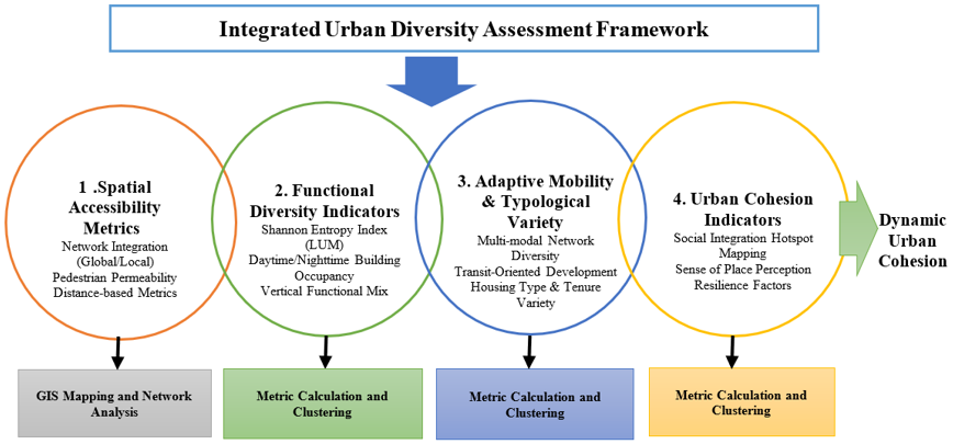
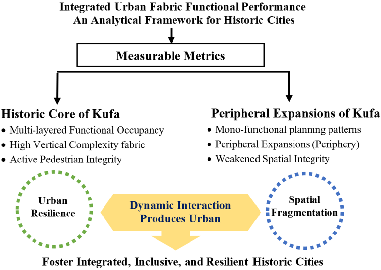
Land use diversity takes three spatial forms: horizontal mixing, vertical mixing, and a combination of horizontal and vertical mixing. In horizontal mixing, two or more land uses exist side-by-side, sometimes separated by pedestrian walkways or roads. This type of diversity is the most prevalent in many cities. Vertical mixing refers to the presence of two or more uses within the same building, such as commercial use on the ground floor, administrative or medical use on the second floor, and residential use on the remaining floors. This type of mixing is common in commercial areas, especially central ones, due to the need to minimize the use of expensive land. The third form of mixed use combines both horizontal and vertical layouts on the same site [14]. Figure 3 presents the analytical framework.
4.2 Urban cohesion
Urban cohesion is a state of equilibrium that achieves an integrated system, progressing from the smallest to the largest scales to develop the urban system. If any scale within this gradual structure is lost, the entire system becomes unbalanced. Its achievement is influenced by the potential for utilizing partnerships in urban life within institutions, political activities, and decision-making processes. The urban environment can be integrated through its functional and physical mix, achieving social integration instead of isolation, to reach functionally integrated urban performance and a formally integrated physical structure. Functional diversity contributes to creating vibrant cities, which positively impacts urban cohesion. Achieving cohesion among the components and elements of the urban fabric requires the functional, formal, and spatial integration of its elements. The term "urban cohesion" refers to the value derived from the network of positive interaction between people, the structures they inhabit, and the network of public spaces they use. Therefore, for an urban area to be considered cohesive, it must possess:
•Continuity: This refers to mobility and accessibility within the city, ensuring equity, prioritizing active transportation, and creating shared spaces integrated with public transport [17].
•Central Public Spaces: These are spaces that play a pivotal role due to their location, the connections they create, the functions they perform, or the socio-economic and cultural dynamics they foster. They contribute to the overall urban network structure and may offer distinct or unique functions within the neighborhoods or sectors they serve, or at the city center level [18].
•Mixed Use: This refers to a combination of urban functions (residential, utilities, commercial, service, production areas, etc.), allowing for the generation of dynamics. Social, economic, and cultural aspects, as well as public spaces, contribute to territorial unity by promoting equal access to employment [19].
•Diversity: The capacity of a region to accommodate and accommodate diverse user groups (social classes, age groups, cultures, etc.), and the diversity of uses, functions, and housing patterns, resulting in a social mix that benefits from the variety of functions and advantages of freely accessible public spaces [20].
•Identity: This represents the culture and collective or individual relationships of a place, linked to the relationships (between users or between them and the place) and the system imposed by these relationships, and thus to knowledge, signs, symbols, etc. [21].
4.3 Theoretical synthesis: Linking diversity and cohesion
This study aims to fill the gaps in the existing research on the relationship between functional diversity and urban cohesion, given the limited number of studies in this area. The research framework addresses the existing theoretical framework, which suggests that for an urban area to be cohesive, it must contain a diverse mix of urban functions. To achieve this, the study employs multiple criteria and metrics for the variables. GIS-based comparative mapping and descriptive and statistical analyses were used to test the hypothesized relationship between functional diversity and urban cohesion.
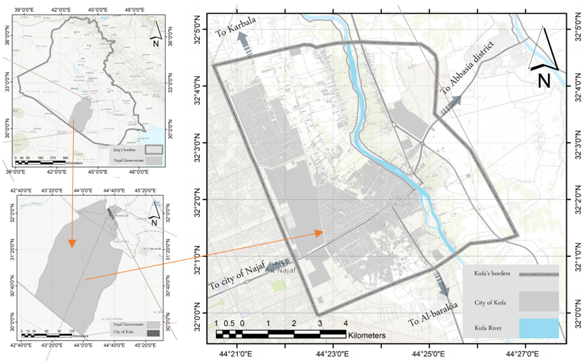
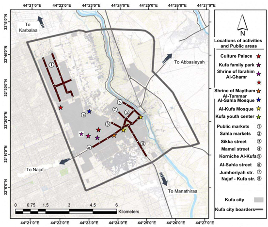
Kufa is one of the oldest cities in Iraq, and the second city built in the Islamic era after Basra. Before Islam, it was known as Suristan. After the Arabs settled there, it became known as Kufa, meaning "a round place of pebbles and sand" (according to a French text). After 36 AH, Kufa became the capital of the Islamic state, a significant turning point in its history when Imam Ali (peace be upon him) decided to depend on this city and on their brave, faithful and responsive soldiers in a city which was (and still today) full of his followers and his loyally believers to strength the Islamic state (in its late Rashid stage). The city contains a large number of mosques, shrines, historical and religious sites, such as the Kufa Mosque, the shrine of the companion Muslim ibn Aqil (peace be upon him), the Sahla Mosque, the shrine of the companion Maytham al-Tammar, the house of Imam Ali (peace be upon him), and the shrine of Sayyid Ibrahim ibn al-Hasan al-Muthanna. Due to its strategic location, its ancient mosques and valuable archaeological sites, and its regional influence, particularly its religious influence between the holy cities of Najaf and Karbala, Kufa has become a prominent city. Kufa is located in Iraq at latitude 32°15' and longitude 44°21'15'. Geographically, the city of Kufa is located in the northeast of Najaf Governorate, as shown on the map, occupying a distinguished geographical position, situated on the Euphrates River, 12 kilometers from Najaf, the capital of Najaf Governorate, 156 kilometers from Baghdad, and 60 kilometers south of Karbala. Its terrain is a high, flat plain.
The area of Najaf Governorate is 28,824 km², distributed across four districts and eleven administrative units. The Kufa district covers an area of 437 km², and the population size in the center of Kufa district (urban only, excluding rural areas and other districts) is 149,217 people (Central Statistical Organization and Development Cooperation 2020, 2024). However, Kufa also functions as a service and activity center for the sub-districts of Al-Abbasiya and Al-Hurriya, which together contain approximately 160,000 inhabitants across urban and rural areas. In addition, the surrounding rural settlements of Kufa, including areas such as Albo Hidary and Aal-Isa, comprise nearly 280,000 residents distributed around the city.
Beyond its resident population, Kufa attracts a considerable number of visitors from holy Najaf and neighboring districts due to economic, social, emotional, and religious ties. The city’s religious significance, particularly the presence of major sacred sites such as the Kufa Mosque and Sahla Mosque, generates regular visitation, especially on Thursday evenings and during major religious occasions, including Arbaeen. Owing to its historical and religious importance, Kufa has become a major destination for visitors from surrounding regions, contributing significantly to its urban vitality and functional dynamics, which have given it strategic importance and directly contributed to its development and urban growth. Kufa's location between the western plateau, which provides livestock products, and the alluvial plain, where intensive agricultural production takes place, makes it a hub of commercial activity between the city and its surrounding administrative districts. The presence of the Great Mosque of Kufa, religious shrines such as the shrine of Muslim ibn Aqeel, and archaeological sites such as the Emirate Palace has given the city of Kufa a religious and archeological character that attracts visitors and tourists from all over the world. Figure 4 illustrates the location of Kufa.
Based on the indicators derived from the theoretical section in Tables 1 and 2, the study area will be analyzed and discussed accordingly, as follows:
Table 1. Indicators of functional diversity performance and resilience
|
Variable |
Dimension |
The Index |
Measurement Method |
|
Functional diversity (independent variable) |
Diversity of land uses |
Land Use Diversity Index |
(Shannon Entropy Index (ENT)) |
|
Functions mixing |
Ratio of non-residential to residential uses |
(Non-residential area ÷ Residential area) |
|
|
Number of functions within walking range (400–800 m) |
Network Buffer |
||
|
spatial distribution |
(Location Quotient) |
Kernel Density |
Table 2. Urban cohesion indicators
|
Variable |
Dimension |
The Index |
Measurement Method |
|
Urban cohesion (dependent variable ( |
Spatial Cohesion |
Urban Communication (Connectivity) |
Depth map X |
|
Accessibility |
Time to Access Services |
(Network Analysis) |
|
|
Functional Cohesion |
Continuity of Urban Activity |
Day-night activity |
|
|
Multiple Uses of Space |
Photo Documentation |
6.1 Functional diversity
It includes indicators of diversity in land uses, the number of jobs within the walking range, and the spatial concentration of activities, through which the extent of distribution and concentration of activities within the city can be known. A balanced distribution of jobs promotes social cohesion and ease of access between parts of the city. Likewise, individuals’ positive perception of the urban spaces in which they carry out their daily activities increases social interaction and strengthens urban cohesion.
6.1.1 Diversity of land uses
It is an important indicator that shows us the extent of the diversity of land uses in the study area and its impact on urban cohesion. This indicator can be measured by using the ENT, which is a measure of mixed land uses. It takes into account the percentage of a number of uses, provided that there are two or more types within the urban area. The value of this index ranges between (0) and (1). If the value is 1, this expresses the ideal value for land uses, as it indicates a large diversity and equal distribution of land uses. When the value is close to (0), this indicates the dominance of one use over another, which is undesirable in city design [22]. The diversity of land uses was quantified using the normalized Shannon entropy (the ENT). The Shannon entropy H for an area with k land‑use categories is:
$H=-\sum_{j=1}^k P^i \ln \left(P^i\right)$
where, $P^i$ is the proportion (percentage divided by 100) of land area occupied by category j. To obtain an index that ranges between 0 and 1, we normalize H by dividing by the maximum possible entropy (which occurs when all k categories are equally present). The normalized ENT is therefore:
$E N T=-\left[\sum_{j=1}^k P^i \ln \left(P^i\right)\right] / \ln (k)$
where,
k is the number of land uses.
$P^i$ is the percentage of each use within the urban area.
ENT = 0 indicates complete dominance by a single category, while ENT = 1 indicates perfectly even distribution among the k categories. In this study, k = 13 because we classified the city into 13 distinct land‑use categories (listed below). By applying the formula above to the whole city of Kufa (using the category proportions reported in Table 3), Results clear that residential and educational uses are relatively large, while economic/service categories are more limited. By applying the above equation to the entire city of Kufa, as shown in Table 3, we find that the entropy coefficient for Kufa is (0.624), a relatively good average value compared to the maximum value (1). This indicates the diversity of land uses in Kufa, meaning that the city does not suffer from the absolute dominance of a single use, but it has not yet reached optimal functional equilibrium. Despite the dominance of residential use at 51%, as shown in Table 3, followed by educational use at 21%, a high percentage compared to similar cities, Kufa has a scholarly-religious character that generates intense daily activity and fosters urban interaction. As for the use of green spaces and orchards (9.14%), this is a good percentage and represents an important environmental and cultural asset. It contributes to improving the quality of life and reflects a cultural dimension linked to the stability and historical agricultural identity of the city. The uses of (commercial + industrial + grain silo) were present at 9.2%, but not dominant. This indicates a local, service-oriented urban economy rather than a large-scale, productive one. As for the uses (artifacts + shrines and tombs), their percentage was 3.1%. They are spatially limited but have a high symbolic impact and a pivotal role in shaping the urban identity and cultural response in the city of Kufa.
Table 3. Land use ratios and entropy values in Kufa City
|
No. |
Land Use |
Area/Hectare |
Ratio% |
Land-use Proportion (Pi) Correct Ratio |
ln Ratio |
The Ratio* ln Ratio |
Entropy Index (ENT) |
|
1 |
Residential use |
852.03 |
51.27 |
0.513 |
-0.67 |
-0.34 |
0.624 |
|
2 |
Commercial use |
62.76 |
3.78 |
0.038 |
-3.3 |
-0.12 |
|
|
3 |
Educational use |
352.25 |
21.19 |
0.212 |
-1.55 |
-0.33 |
|
|
4 |
Antiquities |
44.65 |
2.69 |
0.027 |
-3.62 |
-0.10 |
|
|
5 |
Use of green areas |
105.7 |
6.36 |
0.064 |
-2.8 |
-0.18 |
|
|
6 |
Public services |
62.1 |
3.74 |
0.037 |
-3.3 |
-0.12 |
|
|
7 |
Kufa grain silo |
10.44 |
0.63 |
0.006 |
-5.1 |
-0.03 |
|
|
8 |
Industrial |
79.82 |
4.80 |
0.048 |
-3 |
-0.15 |
|
|
9 |
Orchards |
46.19 |
2.78 |
0.028 |
-3.6 |
-0.1 |
|
|
10 |
Healthy use |
17.57 |
1.06 |
0.011 |
-4.5 |
-0.05 |
|
|
11 |
Sports and youth |
5.76 |
0.35 |
0.003 |
-5.7 |
-0.02 |
|
|
12 |
Shrines and tombs |
6.27 |
0.38 |
0.004 |
-5.6 |
-0.02 |
|
|
13 |
Transportation services |
16.44 |
0.99 |
0.01 |
-4.6 |
-0.05 |
|
|
The total |
1661.98 |
100.00 |
1 |
-47 |
-1.6 |
||
The Shannon ENT uses the proportional area (Pi) of each land-use category as a probability distribution. Accordingly, all categories are treated equally in the mathematical calculation regardless of their planning, cultural, or economic importance. Therefore, the index measures the evenness of land-use distribution, whereas the functional significance of specific land uses (e.g., shrines and tombs) is discussed separately in the interpretation of results.
During the analysis of the entropy coefficient for all land uses in the city of Kufa, it was found that the city enjoys a moderate functional diversity that tends towards good, supported by the weight of residential and educational uses, which contributed to achieving urban cohesion. However, the limited economic and service uses still limit the dynamism and sustainability of this cohesion.
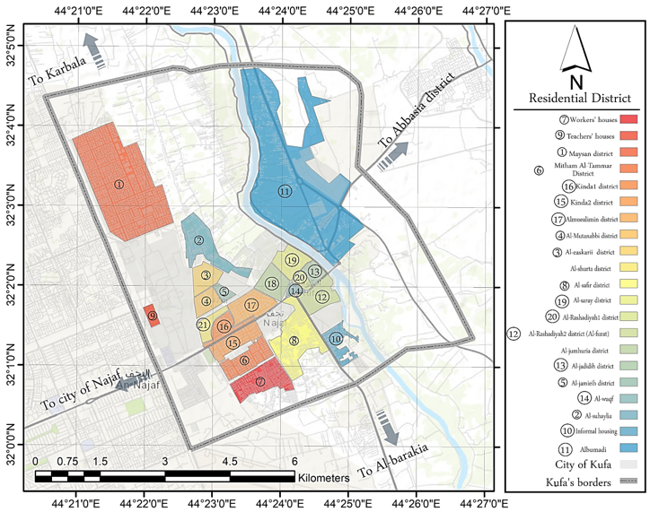
However, when applying the equation to the city's neighborhoods separately, as shown in Figure 5, we find that the ENT values for the neighborhoods of Kufa vary (see Table 4). Higher values indicate greater functional diversity, while lower values reflect the dominance of a single use or a limited functional pattern. Analysis results indicate that the Al-Jamia’a (0.879), Al-Mutanabiy (0.8548), Al-Jidaida (0.77), and Al-Waqf (0.7067) neighborhoods demonstrate high levels of functional diversity within the city's urban fabric; in fact, all of these neighborhoods have been classified as high-level functional diversity spatial units. Al-Waqf Quarter represents a compact historic neighborhood adjacent to Kufa Mosque, characterized by fine-grained traditional street networks, small plot sizes, and high permeability. These morphological conditions contribute to higher accessibility, stronger spatial connectivity, and elevated entropy values compared to peripheral areas. This distinction allows for consistent comparative analysis between peripheral planned expansion areas and dense historic urban fabrics while maintaining methodological standardization across samples.
Table 4. Entropy coefficient for Kufa neighborhoods
|
Neighborhoods of Kufa City |
Entropy Index |
Level |
|
Saray |
0.445 |
Weak |
|
AlBou-madi |
0.662 |
Medium-High |
|
Al-Rashadiyah1 |
0.588 |
Medium |
|
Al Waqf |
0.7067 |
High |
|
Al-Rashadiyah2 |
0.612 |
Medium-High |
|
Al-safir |
0.1699 |
Very Weak |
|
Maytham Al-Tammar |
0.545 |
Medium |
|
Kinda2 |
0.584 |
Medium |
|
Al-Suhailiya |
0.532 |
Medium |
|
Al-muealimin |
0.5467 |
Medium |
|
Kinda1 |
0.45 |
Weak |
|
Al-shurta |
0.6995 |
Medium-High |
|
Al-Jamiai |
0.879 |
High |
|
Aleaskari |
0.6615 |
Medium-High |
|
Maysan |
0.384 |
Very Weak |
|
Al-mutanabiy |
0.8548 |
High |
|
Al-jumhuria |
0.64 |
Medium-High |
|
Al-Jadeeda |
0.77 |
High |
Additionally, these neighborhoods have a fairly balanced mix of residential, commercial, service, and religious or administrative functions contributing to increased social interaction, accessibility, and improved urban cohesion.
In contrast to the previous sentence, the Entropy score for Al-Safir (0.1699) and Maysan (0.384), both low-entropy neighborhoods, demonstrates very limited functional diversity, primarily representing only one or a few different types of uses (most commonly residential) within the community. Maysan Quarter was classified as an independent peripheral sample due to its distinct spatial and functional characteristics, including its location at the urban edge of Kufa and its relative independence from the historic core. It exhibits a self-sufficient service structure, including local markets, health facilities, public services, and administrative functions, reflecting a more recent planned expansion with reduced dependence on the city center. When considering functional diversity distributions in each neighborhood, both Maysan and Al-Safir lack the characteristics related to urban attractiveness and therefore do not provide opportunities for multiple community members to use or interact with public space or with one another; consequently, these two neighborhoods could be classified as having very little urban cohesion. Other neighborhoods throughout the city, such as Al-Rashadiyah, Kinda, Al-Suhailiya, Maytham Al-Tammar, and Al-Mualimeen (Teachers quarter) possess medium-to-medium-high Entropy scores (0.53–0.66), suggesting that many neighborhoods in Kufa provide some level of functional diversity and opportunities for residents to utilize a range of services and activities, but do not possess the level of functional integration necessary to sustain urban planning and social interactions.
Values were classified into five operational categories. Since the Shannon ENT does not define standard threshold values, the classification adopted in this study is analytical rather than universal. The thresholds are: Very Weak (ENT < 0.40), Weak (0.40 ≤ ENT < 0.50), Medium (0.50 ≤ ENT < 0.60), Medium-High (0.60 ≤ ENT < 0.70), and High (ENT ≥ 0.70). These categories were used solely to compare the relative levels of functional diversity among neighborhoods within the study area as shown in Table 4.
6.1.2 Functional mix
It is the ratio of different land uses for a given area in hectares per unit area, and through it one can know the ratio of residential uses to non-residential uses, as well as the number of jobs within the walking area. The more cohesive the morphology of the city, the more effective it becomes in accommodating all the urban functions of its residents and the more effective it is in providing easy access to services, which makes it easier for pedestrians to reach their destinations due to the relative proximity of services:
Table 5. Level of land use mixing for the entire Kufa City
|
Neighborhoods of Kufa City |
Residential Area/Hectare |
Other Uses Area/Hectare |
Ratio |
Level of Mixing |
|
AlBou-madi |
64.08 |
87.05 |
1.36 |
High |
|
Saray |
22.00 |
7.73 |
0.35 |
Weak |
|
Al-Rashadiyah1 |
7.21 |
2.27 |
0.31 |
Weak |
|
Al Waqf |
3.75 |
2.06 |
0.55 |
Medium |
|
Al-Rashadiyah2 |
23.14 |
10.84 |
0.47 |
Weak |
|
Al-safir |
58.33 |
5.38 |
0.09 |
Very Weak |
|
Maytham Al-Tammar |
26.53 |
9.49 |
0.36 |
Weak |
|
Kinda2 |
23.34 |
9.70 |
0.42 |
Weak |
|
Al-Suhailiya |
22.86 |
8.31 |
0.36 |
Weak |
|
Al-muealimin |
28.91 |
9.08 |
0.31 |
Weak |
|
Kinda1 |
16.49 |
5.31 |
0.32 |
Weak |
|
Al-shurta |
11.86 |
5.7 |
0.48 |
Weak |
|
Al-Jamiai |
4.51 |
3.19 |
0.71 |
Medium |
|
Aleaskari |
14.35 |
11.70 |
0.82 |
Medium |
|
Maysan |
190.56 |
64.88 |
0.34 |
Weak |
|
Al-mutanabiy |
11.79 |
17.20 |
1.46 |
High |
|
Al-jumhuria |
19.95 |
19.89 |
1.00 |
Medium |
|
Al-Jadeeda |
8.33 |
9.77 |
1.17 |
High |
Ratio of Non-Residential to Residential Uses: Analyzing the ratio of non-residential land use area to residential land use area, the ratio is determined from (0-1), where the closer it is to (1), the higher the ratio, indicating greater diversity in functions (commercial, service, educational, administrative) and ease of movement within the neighborhood. The closer it is to (0), the lower the ratio, indicating the dominance of residential use and weakness in commercial and service activities. See Table 5 for the city of Kufa, which shows the level of mixing. We note that there are varying ratios of mixing for the neighborhoods of the city of Kufa, where values that fall within (ratio ≥ 1.0) are neighborhoods with high functional mixing, values that fall between (0.6–1.0) are neighborhoods with medium functional mixing, while values that fall within the ratio between (0.3–0.5) are neighborhoods with weak functional mixing.
6.1.3 Number of functions within walking range 400–800 m
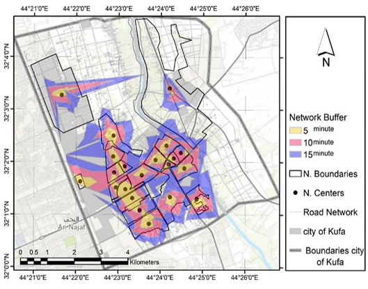
The ability of residents to access various services within a neighborhood or district on foot, within acceptable walking distances, is determined by several studies. These studies consider the distance a person travels from their residence to commercial and service facilities, bus stops, and recreational areas and public spaces. The shorter the distance, the easier it is to access these services [23]. In the city of Kufa, an analysis of the walking buffer zone using the network buffer and GIS software (Figure 6) shows three walking buffer zones to the neighborhood center, based on time and distance. A map of Kufa reveals a concentration of short walking buffer zones around service centers (N. Centers), particularly in the southern part and the urban center. This indicates a concentration of services in the urban center, along with a dense, interconnected road network. Areas outside the service buffer zone suffer from spatial inequity in service distribution and rely heavily on car transportation to reach service centers.
Figure 6 shows an analysis of the walking range (500 m) across the road network, revealing spatial disparities in accessibility to service centers, with the highest access levels concentrated in areas with high functional mixing, while peripheral neighborhoods suffer from poor coverage within the walking distance, reflecting the need to redistribute services and improve pedestrian infrastructure to achieve spatial equity and urban sustainability.
Figure 6. Walking ranges within (400-800) meters for the urban centers of all neighbourhoods of Kufa
6.1.4 Spatial distribution
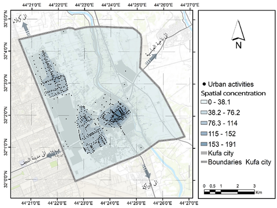
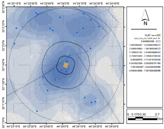
An indicator to determine how different activities are distributed throughout the city is the Kernel Density index. This index indicates the organization of activities and services throughout the city, showing the functional balance as well as providing an indication of spatial equity. The Kernel Density index has a large and direct impact on the level of mixed-use, how easily accessible services are, and how well the various functions and uses work intermixed throughout the urban area. We used GIS tools to create the functional concentration index, which quantifies the level of functional concentration using the Kernel Density index to measure the degree to which activities are concentrated within a particular urban environment. Figure 7 shows several values ranging from the lowest (0-38.1) to the highest (153-191). A higher value indicates a greater number or closer proximity of functions within that area compared to others. Conversely, a lower value indicates a less densely populated area. Higher density levels indicate areas with continuous functional activity and human movement, which promotes urban integration and increases socio-economic activity. Lower density levels on the periphery indicate weaker functional diversity and reliance on the center to meet daily needs. For the high density cultural and religious uses grounded in Kufa’s historically documented scholarly-religious significance as a center of Islamic scholarship, different sciences, Arabic grammar, and Qur’anic sciences, which historically contributed to the concentration of educational institutions. While contemporary religious scholarship is predominantly centered in Najaf and its Hawza system, Kufa’s historical educational identity remains a relevant contextual factor influencing land-use characteristics.
From Figure 7 of the city of Kufa, we observe the presence of high-density areas in the central and western parts of the city. These areas represent functional centers of attraction (commercial, service, and administrative), indicating the dominance of the city's urban center. The density of activities decreases, and residential use becomes more prevalent, as we move towards the outskirts. From the above, we conclude that the degree of functional concentration in Kufa is highest in the center, thus playing a functional role in organizing the relationship between the population and the urban space.
These functions transform into urban attraction points and transportation networks, which enhance the city's urban cohesion. As for the city's outskirts, they need a redistribution of functional activities to achieve functional and spatial integration.
6.2 Urban cohesion
Urban cohesion includes a set of important indicators that achieve connectivity in the measurements of the parts of the urban fabric, which are spatial cohesion, which expresses the urban connectivity of the kinetic network within the city, as well as the ease of access to activities and services, as well as functional cohesion. Through these indicators, a functional and physical mix can be achieved that achieves social integration instead of isolation to reach functionally integrated urban performance and a cohesive physical structure:
6.2.1 Spatial cohesion
Spatial cohesion is a fundamental concept in contemporary urban development, reflecting the organization of urban space and the interconnectedness of urban, functional, and social components in a way that achieves efficient urban performance and equitable distribution of activities and services within the city [24]. The spatial dimension is considered one of the principal elements in shaping urban space, as it is viewed not only from a physical perspective but also as a structure produced through social relations and various patterns of interaction among individuals. Space is not merely a reflection of society; rather, it acts as an active instrument in shaping and organizing social relations. The spatial dimension can be identified and assessed through the measurement of several indicators, including connectivity, accessibility, continuity, permeability, and urban expansion trends, as follows:
6.2.2 Connectivity
The connectivity of the transportation network is a key spatial indicator for measuring urban cohesion. It is expressed as the ratio of the number of intersections to the area (in hectares), reflecting the degree of interconnection of the street network and the ease of access and movement within the city. High levels of connectivity in street and road networks indicate increased spatial connectivity efficiency and improved accessibility between different urban locations. In turn, that makes commuting less physically far between where we live and where we are going for our daily activities, thereby improving our functional integration and spatial cohesion in the urban fabric [25].
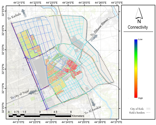
Also, a high-quality level of connectivity supports active transportation patterns and provides more opportunities to socialize in public spaces. The observation of temperature bands shows that high-value connectivity (marked by warmer colors) is primarily concentrated in the historical city center. As you proceed from the city center toward its outer edges, connectivity becomes progressively lower. This means that central areas have a dense and interconnected road network characterized by short segment lengths, numerous intersections, and high traffic permeability. This facilitates access between different urban functions and supports active mobility patterns such as walking. This high level of connectivity contributes to enhanced social interaction, increased use of public spaces, and strengthened spatial cohesion, all essential elements in achieving urban cohesion.
In contrast, peripheral neighborhoods exhibit low levels of connectivity, as evidenced by the prevalence of cool colors, reflecting weak urban network integration, long section lengths, few intersections, and a layout with parallel or relatively closed streets. This pattern reduces opportunities for inter-communication and daily interaction, contributing to the emergence of urban enclaves less integrated into the overall city fabric, thus weakening urban cohesion see Figure 8.
6.2.3 Accessibility
Accessibility is a characteristic of a well-functioning city or urban area. It is a fundamental pillar that enhances urban cohesion and allows us to understand the interrelationship between transportation and land use. Streets are axes and pathways used by people to reach their destinations, which are represented by land uses and various activities, within a specific timeframe [26]. Accessibility can be measured by the time to access services. Most designers plan spaces in a way that ensures proximity to services and connects them to public streets to facilitate residents' access to various services. The shorter this distance, the more functionally integrated and interconnected the urban fabric becomes. The measurement of time to access services is based on the ability of residents of a neighborhood or area to reach various services within 10 minutes, which is equivalent to a 500-meter walk. Figure 9 illustrates this using the Network Buffer model within specific timeframes (5, 10, 15). (Minutes). Urban centers have effective access to many basic services in and around them due to the high density of roads and urban functions being located in proximity. This facilitates greater convenience for residential areas that are within proximity to the urban center, thereby promoting active mobility by walking and encouraging people to commute to work via any means (i.e., bus, bike, etc.). However, peripheral areas do not have adequate direct access to services, which leads to a decreased level of social interaction and urban coherence within the city, as illustrated in Figure 10. The concentration levels of religious and cultural symbols within the master plan boundaries of Al-Kufa exhibit distinct spatial variations.
6.2.4 Functional cohesion
Functional cohesion is defined as the degree of social, functional, and spatial interconnectedness among the components of a city.
The higher the level of functional cohesion, the greater the daily social interaction throughout the day and night, and the higher the sense of security and belonging to the place. This is a fundamental element for making cities cohesive and sustainable [27]. The degree of functional cohesion of a city can be assessed through field observations of population movement at different times of day. The presence of integrated functions within a single neighborhood reduces the spatial separation between housing, work, and services, and limits reliance on long commutes. This, in turn, promotes intensive use of public spaces and strengthens social bonds.
6.2.5 Functions within walking distance (400–800 m)
Figure 10 illustrates an analysis of a 500 m walking distance through the road network, revealing spatial variations in accessibility to service centers.
The highest levels of accessibility are concentrated in areas with high functional diversity, while peripheral neighborhoods suffer from limited service coverage within walking distance. This reflects the need to redistribute services and improve pedestrian infrastructure to achieve spatial equity and urban sustainability.
6.2.6 Multiple uses of space
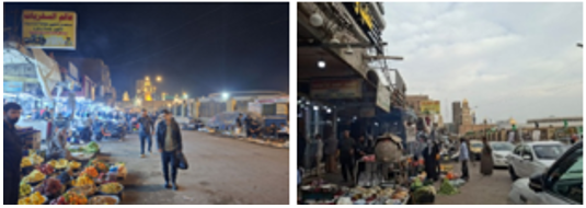
It is the possibility of employing the same physical space to perform multiple functions simultaneously or over different time periods to achieve higher efficiency in the use of spatial resources, as the space is used in multiple roles such as combining social, cultural, and economic activities within the same space. This pattern enhances social interaction within public spaces and increases their vitality [28]. The city of Kufa is distinguished by the presence of public spaces and squares, especially near its religious and cultural centers. Through field monitoring, we notice a doubling of commercial activity, social and religious activities, and pedestrian-only movement in front of the Sahla Mosque in the evening. During the day, car traffic returns to the same area, and this multiple use of space strengthens belonging to the place, social interaction, and continuity of life in public spaces, which enhances urban cohesion.
6.2.7 Continuity of urban activity
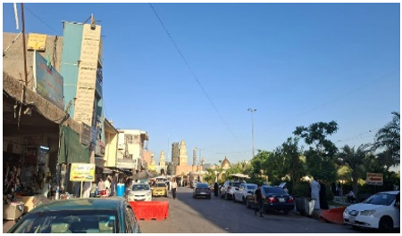
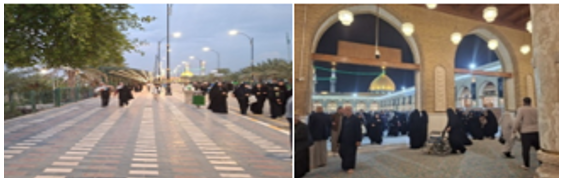
The continuity of the use of urban spaces and urban functions throughout the day (night and day) and on a daily basis, which ensures the continuous movement of the population and social interaction within the urban fabric, is characterized by the city of Kufa, according to its religious character, with continuous urban activity, see Figures 11-13, especially in the central areas of the city close to the religious shrines, where this characteristic gave it the continuity of some urban activities to remain active throughout the day, which enhanced the vitality and cohesion of the city.
Figure 11. Multi-functional urban structure in the city center at Sahla Street, including religious, public, green, and commercial uses with mixed vehicular and pedestrian circulation
As for the peripheral neighborhoods that suffer from functional separation and the dispersal of urban activities, there are fewer opportunities for movement and daily interaction of the population, which leads to the interruption of urban activity, which negatively affects the feeling of security and belonging and weakens urban cohesion.
Figure 13. Continuous population movement during day and night in the center of Kufa
6.2.8 Spatial continuity
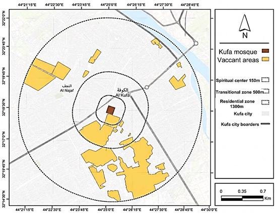
Spatial continuity refers to the degree of connectivity and coherence within the urban fabric that supports uninterrupted movement and perceptual flow. In Kufa, abandoned and underutilized areas near the historic center account for a significant share of the core zone, contributing to fragmentation around the Great Mosque of Kufa and surrounding archaeological sites, including Qasr Al-Imara and areas extending toward the shrine of Maytham Al-Tammar and Al-Sahla Mosque. This fragmentation weakens visual and spatial continuity and reduces the overall cohesion of the historic urban landscape. The lack of integrated open-space planning and weak functional linkages further disrupt the perceptual unity of the city center. So, enhancing spatial continuity requires reconnecting heritage sites and open spaces into a coherent urban network that strengthens both historical identity and urban cohesion, see Figure 14.
6.3 Historical or temporal continuity
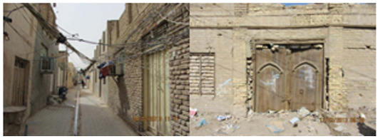
This indicator refers to the ability of a space or building to maintain its function over time while preserving its identity and primary role, with the possibility of adaptive reuse in a manner consistent with its historical significance. Temporal continuity extends beyond physical form to include the persistence of cultural and social meanings associated with a place. In the city of Kufa, several buildings continue to preserve their historical character and spiritual meanings derived from religious and historical narratives. The Great Mosque of Kufa, despite undergoing renovation using non-local materials, has retained its symbolic significance in the collective memory of visitors through its central courtyard and sacred sites, including the Maqam of the prophets and the Mihrab of Imam Ali ibn Abi Talib (peace be upon him). The mosque has continuously maintained its religious function since its establishment, accompanied by a steady increase in visitor movement over time, as illustrated in Figure 15. Similarly, the markets and streets surrounding the mosque continue to sustain commercial activities, closely linked to religious and social practices in the area. In addition, many traditional houses and alleyways within the historic city have preserved their original urban form and traditional character, as shown in Figure 15.
Figure 15. Traditional houses and alleyways in the Historic City Center of Kufa
6.3.1 Permeability indicator
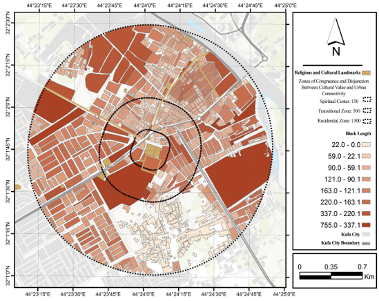
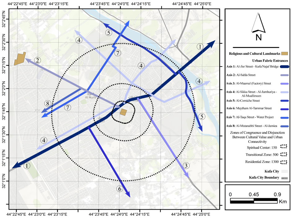
Urban permeability in Kufa was assessed through two sub-indicators: block lengths and urban fabric entrances. Within the 1300 m range, Figure 16 shows 455 blocks with lengths ranging from 70–200 m, out of approximately 967 blocks.
The study area includes several major entrances connected to principal movement corridors, including Al-Jisr, Al-Sahla, Al-Maamal, Al-Sikka, Al-Cornish, Maytham Al-Tammar, Al-Taqa, and Al-Mutanabbi streets. These routes connect the Mosque of Kufa with surrounding areas, improving accessibility and reinforcing daily urban activity in the historic center, as shown in Figure 17.
6.4 Spatial growth direction
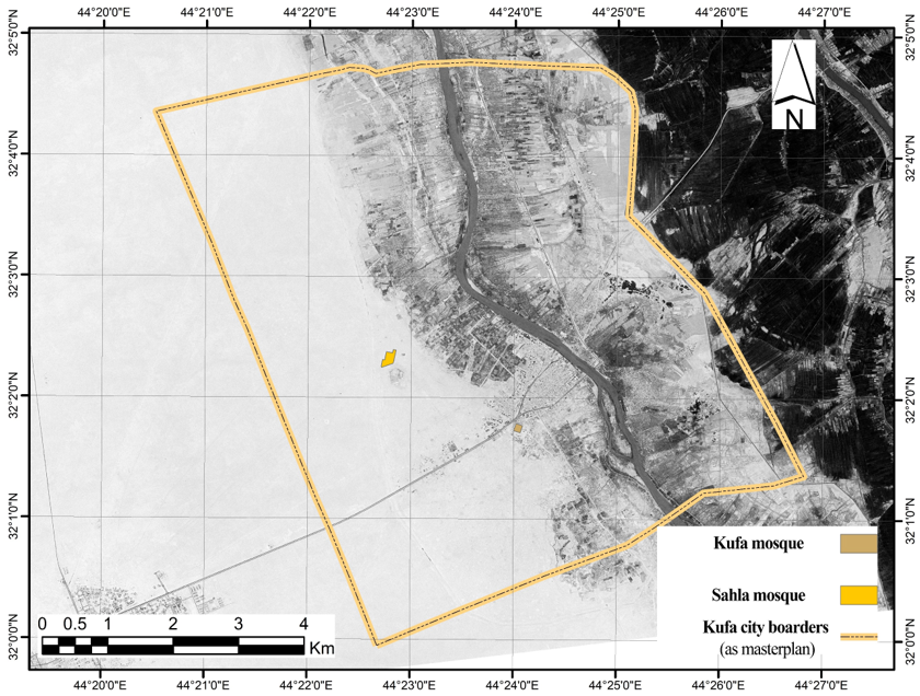
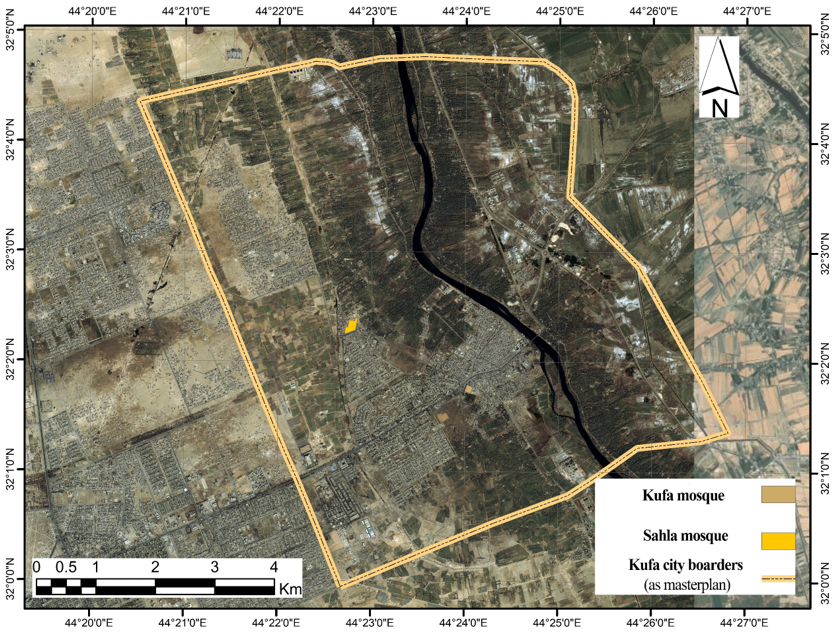
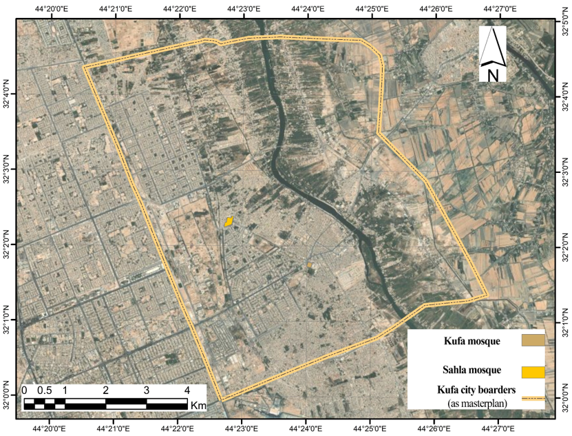
Spatial growth in Kufa was analyzed using historical maps and aerial imagery (1968, 2000, 2025) to assess urban expansion around the Great Mosque of Kufa. In 1968, development was concentrated in the historic core, with expansion mainly toward the northeast and northwest, strengthening accessibility, functional diversity, and urban cohesion around the center.
6.4.1 Urban expansion of Kufa City in 1968
Following the 14 July Revolution and residential land distribution, new neighborhoods emerged, supported by rural–urban migration driven by employment and services. Early expansion in Kufa concentrated around the Great Mosque of Kufa, extending mainly northeast toward the river and movement corridors, with dense development in Al-Waqf, Al-Jadida, Al-Saray, and early Al-Jumhuriya.
6.4.2 Urban expansion of Kufa City in 2000
Compared with 1968, Kufa experienced substantial urban growth while maintaining expansion around the historic center and toward the northeast. New planned neighborhoods emerged to the north and west, including Maysan, Al-Askari, Al-Mutanabbi, and Al-Jami’a, accompanied by relative improvements in road networks and urban cohesion, particularly near the city center and major movement corridors, see Figures 16-20.
6.4.3 Urban expansion of Kufa City in 2025
By 2025, Kufa experienced rapid and complex urban growth. The historic core remained cohesive with dense fabric and improved infrastructure, while the periphery expanded irregularly over agricultural land, forming informal settlements with limited services. Despite new educational and religious developments, urban cohesion remained strong in the center and weaker in peripheral areas.
The results show that functional diversity is an empirically measurable spatial mechanism that results in urban cohesion rather than only a planning goal. The ENT indicates that balanced functional distribution maintains Kufa’s historic structure and is the basis for the conclusion that urban cohesion is a product of spatial interaction between different but complementary activities.
7.1 Functional diversity and spatial integration
Kufa's historic core has a strong relationship between functional diversity and cohesion. This supports international urban theory with a strong emphasis on compact, mixed-use urban environments, as found in studies of historic cities throughout Europe and Asia, where diverse activity patterns support pedestrian movement and regular social interactions. The situation in Kufa, however, adds a unique dimension: religious centrality has created a highly concentrated population of functional uses that continually draws a wide variety of people into Kufa's historic core. Peripheral areas, on the other hand, exhibit functional thinning due to the assignment of mono-functional uses and increased dependence on automobiles for mobility. This indicates that a lack of functional diversity greatly contributes to the fragmentation of space.
7.2 Network connectivity as a mediating factor
The findings corroborate previous research by showing that solely having diverse functions does not provide cohesive urban development; only if there is conceptual integration of diverse functions through a spatially integrated network does urban cohesion emerge. Cohesion performance tends to be low for areas with localized functional services but no connectivity to major urban corridors. The role of connectivity here is to serve as a mediating variable combining functional diversity with cohesive performance, thus extending urban design literature. In the case of Kufa, the city’s historic core acts as a spatial anchor for establishing travel patterns and redistributing urban employment activity through the overall integrated urban network.
Table 6 provides a synthesis of functional diversity and network connectivity across the studied neighborhoods. The spatial alignment between high Entropy Index values and high connectivity levels indicates a positive relationship.
Table 6. Comparative assessment of functional diversity and network connectivity
|
Neighborhood |
Entropy Index |
Connectivity Level |
Relationship Alignment |
|
Al-Jamiai |
0.879 |
High |
Strong Alignment |
|
Al-mutanabiy |
0.8548 |
High |
Strong Alignment |
|
Al-Jadeeda |
0.77 |
High |
Strong Alignment |
|
Al Waqf |
0.7067 |
Medium |
Positive Alignment |
|
Al-shurta |
0.6995 |
Medium-High |
Positive Alignment |
|
AlBou-madi |
0.662 |
High |
Strong Alignment |
|
Al-jumhuria |
0.64 |
Medium-High |
Positive Alignment |
|
Al-Rashadiyah2 |
0.612 |
Weak |
Moderate Alignment |
|
Kinda2 |
0.584 |
Medium |
Moderate Alignment |
|
Al-muealimin |
0.5467 |
Medium |
Moderate Alignment |
|
Maytham Al-Tammar |
0.545 |
Weak |
Moderate Alignment |
|
Al-Suhailiya |
0.532 |
Medium |
Moderate Alignment |
|
Kinda1 |
0.45 |
Weak |
Weak Alignment |
|
Saray |
0.445 |
Weak |
Weak Alignment |
|
Maysan |
0.384 |
Weak |
Weak Alignment |
|
AlRashadiyah1 |
0.588 |
Weak |
Weak Alignment |
|
Al-safir |
0.1699 |
Very Weak |
Weak Alignment |
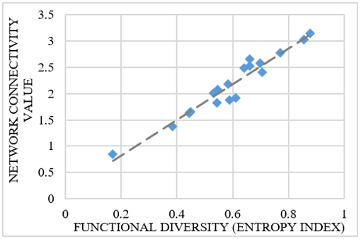
To quantitatively evaluate the spatial relationship between land-use diversity and structural integration across the 18 analyzed neighborhoods of Kufa, a Pearson correlation analysis was conducted using the values compiled in Table 6.
The extremely strong positive correlation (r = 0.94, 95% confidence interval: [0.84, 0.98], p < 0.001), as illustrated in Figure 21, indicates that neighborhoods with higher functional diversity, particularly within the historic core of Kufa, exhibit superior spatial connectivity and pedestrian accessibility. Conversely, peripheral districts with lower entropy index values show significantly reduced network performance, highlighting a clear spatial imbalance in the urban fabric that disrupts overall urban cohesion.
Figure 21. Scatter plot of Pearson correlation between functional diversity (Entropy Index) and network connectivity across Kufa neighborhoods (N = 18)
Neighborhoods with superior street-network integration consistently support a more diverse range of urban functions, while areas with lower connectivity exhibit lower levels of functional mixing. This comparative assessment confirms that spatial configuration is a fundamental determinant of functional diversity in the historic fabric of Kufa.
7.3 Planning implications for the historic center of Kufa
7.3.1 Urban resilience in the city
This research indicates that in order to adapt historic cities to support resilience through their evolution into a mixed-use distributed system, as opposed to continuing as a centralized functional concentration, it will necessitate increased functional diversity in peripheral neighborhoods to reduce gaps in spatial interaction and improve adaptive urban performance. The introduction of the GIS-based metric system established in this research provides a framework for evolving from a descriptive tool used for the evaluation of land use to a reproducible, evidence-based tool capable of informing future urban planning strategies that take into consideration the changing conditions that many historic cities will face.
7.3.2 Pedestrian systems in historic center
Improving the pedestrian system in Kufa City can generate significant urban, social, and functional benefits, particularly when integrated with mixed land uses in the historic center and connected to religious walking routes toward Najaf and Karbala through major corridors leading to Kufa Mosque, Maytham Al-Tammar Shrine, and Al-Sahla Mosque. Enhanced walkability, supported by mixed land uses, can reduce travel distances between residential, commercial, educational, religious, and recreational functions, thereby decreasing dependence on private vehicles. Continuous pedestrian networks, permeable street connections, and high-quality pedestrian infrastructure—including safe crossings, shaded pathways, and accessible sidewalks—can improve mobility, comfort, safety, street vitality, and accessibility for diverse social groups. In Kufa’s historic center, where diverse urban activities concentrate around sacred destinations and public spaces, improved walkability may strengthen urban cohesion by enhancing social interaction, spatial continuity, and connectivity between neighborhoods and activity nodes. Better pedestrian accessibility between religious, commercial, and public functions reinforces functional integration and supports continuous urban activity while preserving Kufa’s historic-religious identity.
However, parts of the holy and archaeological center surrounding Kufa Mosque still require urban design interventions to improve pedestrian quality and promote mixed land uses, including commercial, tourism-related, and daily-service functions for residents and visitors. Such interventions are particularly important given the proximity of the traditional vaulted market, Souk Al-Kufa, and the recently upgraded Euphrates riverside, which has benefited from enhanced pavements, shading, lighting, street furniture, and landscape improvements that support walkability and public-space quality. Moreover, the heritage character of the columned porticos along Sikka Street plays an important socio-cultural and religious role. The street functions as a ceremonial pedestrian corridor for Muharram processions and daily funeral rituals moving toward Kufa Mosque, reflecting the continuity of local spiritual and social practices. Therefore, improving pedestrian quality along Sikka Street through enhanced paving, shading, landscaping, visual cohesion, and mixed land uses is strongly recommended to reinforce Islamic architectural identity and respond to the city’s cultural context. This issue is particularly important given that the 2013 city-center masterplan proposed removing part of the traditional urban fabric along Sikka Street to create a major vehicular corridor connected to a new bridge toward Abbaseiyah district. However, the proposal was widely rejected by residents due to its neglect of the street’s cultural, ceremonial, social, and historical significance.
7.3.3 Public-space renewal
The renewal of Kufa’s public-space network is important for promoting urban cohesion, particularly within the historic and religious structure of the city. When focusing solely on isolated public spaces, strengthening the continuity and integration of streets, plazas, pedestrian corridors, riverside spaces, markets, and sacred destinations can significantly improve spatial connectivity and reinforce relationships between neighborhoods and urban functions. In historic cities such as Kufa, urban cohesion depends not only on the presence of activity centers but also on the quality and continuity of movement networks that connect them. Renewing the public-space network may significantly enhance walkability and permeability across the city. Improved pedestrian infrastructure, including shaded walkways, safe crossings, accessible sidewalks, lighting, and continuous pedestrian routes, can facilitate movement between residential areas and major destinations such as Kufa Mosque, Al-Sahla Mosque, Souk Al-Kufa, educational institutions, and riverside public spaces. Strengthening pedestrian corridors may reduce dependence on private vehicles while improving comfort, accessibility, and mobility for residents, pilgrims, and visitors; it can also reinforce functional diversity by strengthening linkages between religious, commercial, educational, recreational, and residential land uses. Improved spatial connectivity between diverse urban functions may increase urban vitality, encourage continuous activity throughout the day, and reduce functional fragmentation, particularly in peripheral districts. Vacant or underutilized urban spaces located along movement corridors may present opportunities for context-sensitive mixed-use development that supports functional diversity while preserving the visual and cultural significance of Kufa Mosque and surrounding sacred sites.
Moreover, strengthening public-space connectivity may reinforce Kufa’s historic and religious identity. Streets such as Sikka Street, ceremonial religious routes, traditional markets, and riverside spaces function as socially and culturally significant corridors that support collective rituals, everyday social interaction, and religious gatherings. Enhancing the quality and continuity of these spaces through sensitive urban design interventions may strengthen social cohesion, preserve cultural continuity, and reinforce the mosque-oriented spatial character of the city. Therefore, a comprehensive approach to public-space network renewal in Kufa may contribute to urban cohesion by improving spatial continuity, walkability, permeability, functional integration, and social interaction while supporting resilient and culturally responsive urban development.
7.3.4 Historic-city conservation and religious tourism management
Historic-city conservation in Kufa should adopt an integrated approach that combines heritage preservation, tourism development, and public-space enhancement while safeguarding the authenticity of the historic urban fabric and its religious identity. Traditional neighborhoods, visual corridors, mosque-oriented spatial structure, and archaeological sites must be preserved and carefully upgraded to maintain cultural continuity and the symbolic character of the historic center. Tourism development should be supported through diversified services, including three-, four- and five-star hotels, restaurants, cafés, and visitor facilities strategically located near major sacred and historic destinations. These services should be integrated within the urban fabric in a way that supports economic vitality without disturbing the historic character of the city. Improving public-space quality through shaded pedestrian routes, seating areas, signage, and wayfinding systems can enhance accessibility, comfort, and legibility for both residents and visitors.
A key implication is the creation of cultural and religious routes linking Kufa Mosque, Al-Sahla Mosque, Souk Al-Kufa, Qasr Al-Imara, riverside spaces, and surrounding heritage areas. These routes can be supported by sustainable public transport systems and peripheral or underground parking to reduce congestion in the historic core while maintaining pedestrian priority. Historic-site activation is also essential through museums and digital interpretation strategies, including hologram and augmented-reality technologies, particularly at archaeological sites such as Qasr Al-Imara. These interventions can enhance cultural understanding and visitor experience while preserving physical remains.
Importantly, conservation strategies should reinforce Kufa’s cultural identity, particularly its distinctive symbolic heritage expressed through Kufic Arabic script, inscriptions, and architectural ornamentation. Preserving and reinterpreting Kufic calligraphy in urban design, signage, façades, and public art can strengthen the city’s visual identity and spiritual atmosphere. This symbolic layer, combined with heritage preservation and functional upgrading, contributes to a cohesive, legible, and culturally expressive historic city.
Overall, Kufa’s historic-city conservation should balance preservation with contemporary urban needs, integrating tourism infrastructure, sustainable mobility, and cultural identity to enhance urban cohesion and reinforce its unique religious and historical significance.
Urban cohesion remains a central challenge in historic cities undergoing rapid expansion and functional fragmentation. This study operationalizes urban cohesion as a measurable spatial condition by integrating functional diversity metrics with configurational network analysis. The results demonstrate that Kufa’s historic core maintains strong structural integration due to high functional diversity, whereas peripheral expansions reveal spatial fragmentation associated with mono-functional development patterns.
Findings confirm that urban cohesion emerges from the interaction between functional distribution and network connectivity rather than land-use mixture alone. Functional diversity acts as a spatial performance indicator influencing accessibility, pedestrian continuity, and urban vitality. These results highlight the importance of enhancing pedestrian accessibility and reducing functional disparities between historic centers and expanding districts within regenerative and decentralized planning strategies.
The historic city of Kufa should be shaped by the interaction between functional diversity, accessibility, and network connectivity within a religiously and culturally structured urban environment. The findings confirm that the historic core maintains strong spatial integration due to its mixed land uses, pedestrian accessibility, and continuous activity patterns, while peripheral districts experience functional fragmentation, limited accessibility, and weaker urban interaction. Across the analysis, accessibility, walkability, permeability, and public-space continuity emerge as key determinants of urban cohesion, particularly when supported by a well-connected public-space network and integrated land-use structure.
The research further highlights that improving pedestrian systems, renewing public-space networks, and enhancing functional diversity can significantly strengthen spatial continuity and social interaction. These interventions become particularly effective when linked to cultural and religious movement corridors connecting major sacred destinations such as Kufa Mosque, Al-Sahla Mosque, and surrounding heritage sites & integrating historic-city conservation and religious tourism management through sustainable mobility systems, cultural routes, visitor infrastructure, and the activation of archaeological and historic assets.
Finally, the study emphasizes the role of Kufa’s cultural identity, including Kufic Arabic script and architectural heritage, as a symbolic layer that reinforces the city’s visual and spiritual character. Overall, the proposed framework offers a transferable approach for understanding and improving urban cohesion in historic cities through the integration of functional diversity, accessibility, and heritage-based planning strategies.
Beyond the case study, the proposed framework provides a transferable analytical model for evaluating cohesion empirically in historic cities. By redefining cohesion as a quantifiable spatial outcome, the research contributes to ongoing discussions on urban resilience and evidence-based planning. Future studies may incorporate temporal dynamics, socio-economic variables, culturally responsive urban design, and real mobility data to further refine cohesion assessment across diverse urban and historic contexts.
[1] Colantonio, A., Dixon, T. (2010). Social sustainability and sustainable communities: Towards a conceptual framework. In Urban Regeneration & Social Sustainability, pp. 18-36. https://doi.org/10.1002/9781444329445.ch2
[2] Dogan, O., Lee, S. (2024). Jane Jacobs’s urban vitality focusing on three-facet criteria and its confluence with urban physical complexity. Cities, 155: 105446. https://doi.org/10.1016/j.cities.2024.105446
[3] Dovey, K., Pafka, E. (2017). What is functional mix? An assemblage approach. Planning Theory & Practice, 18(2): 249-267. https://doi.org/10.1080/14649357.2017.1281996
[4] Halawani, R. (2024). The effects of public spaces on people’s experiences and satisfaction in Taif City: A cross-sectional study. Land, 13(9): 1529. https://doi.org/10.3390/land13091529
[5] Laurence, P.L. (2006). The death and life of urban design: Jane Jacobs, the Rockefeller Foundation and the new research in urbanism, 1955-1965. Journal of Urban Design, 11(2): 145-172. https://doi.org/10.1080/13574800600644001
[6] Bakshi, A. (2016). The radicals’ city: Urban environment, polarisation, cohesion. Journal of Urban Design, 21(3): 386-387. https://doi.org/10.1080/13574809.2016.1167532
[7] Abdulhamza, E.S., Al-Jaberi, A.A. (2025). Trends in spatial justice in urban space planning: A study of selected urban spaces in 1st Kinda Neighborhood in the City of Kufa-Iraq. International Journal of Sustainable Development and Planning, 20(6): 2519-2531. https://doi.org/10.18280/ijsdp.200620
[8] Pinto, A.J., Remesar, A. (2012). Urban cohesion: A guiding concept for new urban realities. In Ambivalent Landscapes. Sorting Out the Present by Designing the Future, pp. 1-18. https://doi.org/10.13140/RG.2.1.3032.8722
[9] Ghorbi, M., Esmailpoor, N., Naghavi, M. (2022). The study of mixed land-use and social capital in different districts of Kerman City: Case study: Ganjalikhan, Shahr, 24 Azar, Ghadir, and Pansad Dastghah districts. International Journal of Architecture and Urban Planning, 32(4): 62-80. https://doi.org/10.22068/ijaup.637
[10] Cervero, R., Kockelman, K. (1997). Travel demand and the 3Ds: Density, diversity, and design. Transportation Research Part D: Transport and Environment, 2(3): 199-219. https://doi.org/10.1016/S1361-9209(97)00009-6
[11] Montgomery, J. (1998). Making a city: Urbanity, vitality and urban design. Journal of Urban Design, 3(1): 93-116. https://doi.org/10.1080/13574809808724418
[12] Alshamari, H.A., Ismael, N.T., Adelphi, H.S.O., Hamza, S. M. (2022). Promoting the social cohesion in the traditional cities. International Journal of Sustainable Development and Planning, 17(6): 1855-1864. https://doi.org/10.18280/ijsdp.170620
[13] Drici, H., Carpio-Pinedo, J. (2025). Urban land use mix and AI: A systematic review. Cities, 165: 106102. https://doi.org/10.1016/j.cities.2025.106102
[14] Simon, P.B. (1989). Mixed land-use patterns and the development of spatial structure of Nigerian cities. Planning Outlook, 32(1): 43-53. https://doi.org/10.1080/00320718908711844
[15] Abdulameer, H.N., Al-Jaberi, A.A., Al-Khafaji, A.S., Alrobaee, T. R., Al-Ansari, H. A. (2024). Evaluating of urban space vitality: The role of safety, security, and urban planning in the religion center of Kufa City, Iraq. International Journal of Design and Nature and Ecodynamics, 19(1): 155-167. https://doi.org/10.18280/ijdne.190118
[16] Burton, E. (2002). Measuring urban compactness in UK towns and cities. Environment and Planning B: Planning and Design, 29(2): 219-250. https://doi.org/10.1068/b2713
[17] Maimaiti, G., Wang, H., Gong, Y., Luan, S., Zhang, Y., Li, F. (2025). Accessibility and equity in sustainable urban planning: Insights from developed countries for developing cities. Sustainability, 17(23): 10506. https://doi.org/10.3390/su172310506
[18] Pineda, V.S. (2020). Building the Inclusive City: Governance, Access, and the Urban Transformation of Dubai. Springer International Publishing, Cham. https://library.oapen.org/handle/20.500.12657/22843.
[19] He, Y., Liu, B., Xu, C., Wu, D. (2025). Literature review on public transport and land use: Based on CiteSpace statistical analysis. Land, 14(5): 1096. https://doi.org/10.3390/land14051096
[20] Durán-Pérez, A.M., Núñez, J.M., Gómez Gámez, C. (2025). Spatial equity in access to urban parks via public transit: A centrality-driven assessment of Mexico City. Land, 14(9): 1773. https://doi.org/10.3390/land14091773
[21] Gao, T., Lim, S., Yang, F. (2025). Space appropriation and interaction: How to promote social cohesion in high-density urban environments? Cities, 167: 106338. https://doi.org/10.1016/j.cities.2025.106338
[22] Faiz, M., Faridi, R.A., Ben Hasher, F.F., Boltižiar, M., Zhran, M. (2026). Quantitative assessment of urban sprawl dynamics in Moradabad City using built-up expansion index and Shannon’s entropy (1994-2024). Land, 15(7): 1212. https://doi.org/10.3390/land15071212
[23] Xu, J.L. (2017). Is New Urbanism changing the suburban development pattern? A case study of the Toronto region. Journal of Urban Design, 22(6): 812-832. https://doi.org/10.1080/13574809.2017.1337494
[24] Abdelmalek, H. (2026). Institutional configurations of spatial justice in Cairo: Islamic urban governance and gated urbanism in comparative perspective. Urban Studies, 1-18. https://doi.org/10.1177/00420980261453837
[25] Al-Jazaeri, H.M.J., Allawi, A.H., Abdulameer, H.N., Al-Jazaeri, H.M.J. (2024). Environmental planning and spatial modeling for wind energy farm sites (Case study: Najaf Secondary Region). International Journal of Sustainable Development and Planning, 19(9): 3553-3565. https://doi.org/10.18280/ijsdp.190923
[26] Hamidi, S., Ewing, R., Preuss, I., Dodds, A. (2015). Measuring sprawl and its impacts: An update. Journal of Planning Education and Research, 35(1): 35-50. https://doi.org/10.1177/0739456X14565247
[27] Talen, E. (1999). Sense of community and neighbourhood form: An assessment of the social doctrine of New Urbanism. Urban Studies, 36(8): 1361-1379. https://doi.org/10.1080/0042098993033
[28] Carmona, M. (2010). Public Places, Urban Spaces: The Dimensions of Urban Design. Routledge, London.