Ablaikhan Baukhan | Aizhan Zhildikbayeva* | Timur Rafikov
© 2026 The authors. This article is published by IIETA and is licensed under the CC BY 4.0 license (http://creativecommons.org/licenses/by/4.0/).
OPEN ACCESS
In the context of the growing anthropogenic load on the natural resources of the foothill territories of Kazakhstan, the spatial assessment of ecological limitations becomes especially important in land use planning. In this study, a multi-criteria analysis (MCA) was carried out using geographic information systems (GIS) to identify environmentally vulnerable zones in the Zhambyl region, Kazakhstan. The criteria used in the analysis were terrain slope, soil type, precipitation, proximity to water sources, and the characteristics of the soil cover. All parameters were normalized and weighted through the weighted linear combination (WLC) method in the ArcGIS environment. The study aimed to develop a spatial analysis technique using MCA to identify ecological limitations and classify the region's pasturelands according to their suitability for sustainable use. As a result, a pasture suitability map was created, identifying 43% of the territory as highly suitable for grazing, 38% as moderately suitable, and 19% as unsuitable due to pronounced ecological limitations. The technique proved the effectiveness of integrating open spatial data (Shuttle Radar Topography Mission (SRTM), WorldClim, HydroSHEDS, SoilGrids) and GIS tools for the objective assessment of pasture resources. The scientific novelty of the work lies in the comprehensive adaptation of the MCA and the WLC methods to the regional conditions of the arid ecosystems of Kazakhstan. The practical significance of the study lies in the possibility of applying the proposed approach in other arid regions of Central Asia for the purposes of rational planning of pastoral land use and the prevention of degradation processes.
geographic information systems, sustainable development, pastures, multi-criteria analysis, environmental constraints, Zhambyl region
The modern challenges of sustainable environmental management against the backdrop of climate change, soil degradation, and unsustainable land use require an integrated and scientifically grounded approach to land management. This is especially true for the Zhambyl region, distinguished by a variety of landforms, an arid climate, limited water resources, and a high load on pastureland. These territories play an important role in ensuring food security and agricultural development in Kazakhstan, but are also subject to severe and widespread land degradation. Predominant types of degradation in Central Asia, including Kazakhstan, encompass accelerated erosion, desertification, and salinization processes that significantly worsen the ecological state of the region [1, 2]. Pasture degradation manifests through a decline in forage productivity, run-down vegetation cover, and the disappearance of natural grains, impacting biodiversity and rural resilience [3, 4]. These issues are exacerbated by increasing anthropogenic pressures, primarily unregulated livestock grazing and overgrazing, which have degraded a large proportion of Kazakhstan's pasturelands due to historical transformations and a lack of clear institutional regulation [4-7]. Additionally, unstable agriculture, inappropriate farming practices, and poor irrigation systems contribute to these problems [2]. Climatic factors such as increasing climate instability, the growing frequency of extreme weather events, water resource scarcity, and drying trends further intensify the degradation processes, underscoring the urgent need for robust land assessment tools to prevent further degradation and ensure sustainable resource utilization [4, 8, 9].
When local data is scarce, access to a variety of open spatial data (digital elevation models (DEM), soil and climatic maps, hydrography, and soil cover) makes it possible to use geographic information systems (GIS) and multi-criteria analysis (MCA) for the spatial assessment of ecological limitations. This approach allows for the objective identification of areas that are unsuitable or require additional protection measures when used for economic purposes, as well as provides the basis for sustainable land use planning [10]. Using MCA in combination with GIS, it is possible to simultaneously consider several environmental factors that affect the suitability of land for certain types of use. This is particularly important for arid and semi-arid regions, where even minor planning errors can cause a rapid depletion of natural resources.
The analysis of ecological limitations in land use planning using geographic information technologies and MCA has become widespread in recent decades in both Kazakh and international scientific practice [11]. The development of GIS tools and open access to spatial data create a foundation for more accurate modeling, monitoring, and decision-making in the field of sustainable environmental management. International studies employing GIS-MCA for land suitability assessment often utilize diverse methodologies for criteria weighting, standardization, and integration. For instance, methods like the Analytic Hierarchy Process (AHP) are frequently used to determine criterion weights based on expert opinion and pairwise comparisons [12-15], while other approaches include fuzzy AHP or direct weighted sum methods [16]. Standardization, a critical step due to the heterogeneous nature of spatial data, often involves scaling criteria to a common range (e.g., 0–1 or 1–9) or employing fuzzy linear functions [17, 18]. The choice of criteria also varies, but typically includes bio-physical factors such as land use/land cover, rainfall, water accessibility, slope, and soil types, similar to those considered in this study [19].
In Kazakhstan, the issues of ecological limitations and rational land use have been considered in several scientific works, primarily in the context of pasture degradation, desertification, and soil erosion. Baatar and Tsogt [20] emphasize the significant impact of climate change on land degradation processes in arid regions, comparable to the conditions of the Zhambyl region. A study by Kairat and Nurbekova [10] conducted in southern Kazakhstan stressed the need to introduce remote sensing and GIS tools to increase the efficiency of monitoring and the planning of pasture land use. Research by FAO [21] and Rahman and Saha [22] points to the practical value of MCA and the mapping of vulnerable areas in providing substantiation for soil protection zones, grazing regulation, and water management. The researchers emphasize the importance of an integrated approach that combines climatic, relief, soil, and landscape data. Despite individual thematic analyses of land degradation, there are relatively few implemented projects in Kazakhstan that use MCDA in conjunction with GIS for the spatial assessment of ecological limitations at the regional level. A study by Abdrakhmanov and Zhumanov [23] stands out as one of the few that use this kind of technique in the steppe zones of Kazakhstan.
In international practice, multi-criteria decision analysis (MCDA) in the GIS environment is actively applied in various areas of territorial planning, from agriculture to environmental protection. Some of the most popular methods are weighted linear combination (WLC), hierarchical analysis (AHP), and fuzzy logic [24-26]. The methodology for applying WLC to GIS for decision-making in resource-constrained settings has been substantiated in depth in the work of Saaty [24] and Eswaran et al. [25]; Tadesse and Zeleke [26] have demonstrated its effectiveness in the environmental assessment of pastures in an arid climate.
Many foreign researchers highlight the universality of this approach and its reproducibility in various geographical and socio-economic conditions. These methods are now actively used in Iran, India, Turkey, Eastern Europe, and Central Asia. Kazakhstan, however, still has a shortage of comprehensive spatial studies that identify ecological limitations on pastoral land use using MCA in conjunction with GIS. Existing studies are predominantly local in nature and do not provide a comprehensive view of regional differences in pasture conditions. As a result, land use decisions are often based on fragmented data, which increases the risks of ecosystem degradation and suboptimal pasture load distribution. These circumstances have led to the need to develop a methodology that will integrate remote sensing data, DEM, and soil and climate maps into a single assessment system. This approach will provide a more accurate classification of land by ecological limitations and form the basis for sustainable land use planning at the regional level.
The main goal of this study was to develop and apply a robust GIS-MCA framework, incorporating key bio-physical criteria, for the spatial assessment of pastureland suitability and ecological limitations in the arid Zhambyl region of Kazakhstan, aiming to support science-based sustainable land use planning.
The research objectives were the following:
To identify and substantiate a set of key environmental criteria affecting land development limitations and to collect the necessary spatial data from open sources.
To build an integrated map of ecological limitations in the Zhambyl region based on normalization and the weighting of criteria via the WLC method in the GIS environment.
To conduct the MCA aimed at identifying areas with ecological limitations and assessing their suitability for pastoral use, spatial data were gathered from open sources. Due to its arid climate and high grazing pressure, the Zhambyl region requires a scientifically grounded pasture assessment system. Accordingly, the analysis criteria were chosen based on the factors that have a critical impact on pastureland: terrain slope (erosion vulnerability), soil properties (water retention capacity), climate (moisture availability), access to water sources (livestock watering), and current land use [27].
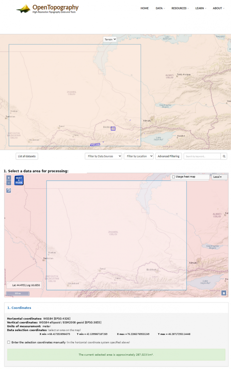
To achieve the set research goal, we utilized various materials. The primary material was a DEM produced by the Shuttle Radar Topography Mission (SRTM, 30 m resolution). Below, we provide the DEM for the territory of the Zhambyl region [28].
The spatial analysis of ecological limitations in the Zhambyl region relied on various types of spatial data, which painted a full picture of regional conditions [29].
Figure 1 shows the active window of the OpenTopography online platform through which the DEM was obtained. These data were used to calculate the slope of the terrain — one of the key factors affecting the erosion vulnerability of pasture areas.
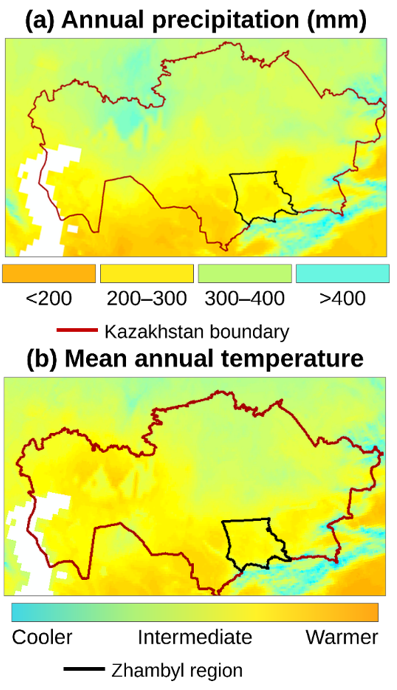
Figure 1 shows the spatial distribution of mean annual precipitation and mean annual temperature in the Zhambyl region based on WorldClim v2 data. These maps provide a visualization of potentially erosive hazardous areas and areas with limitations that preclude intensive pasture use [30].
Figure 1. OpenTopography window
In addition to relief data, the study used:
•Climate data from the WorldClim v2 database, including long-term average monthly precipitation and temperatures spatially interpolated throughout the region's territory;
•Soil maps from the SoilGrids global service (ISRIC), containing information on soil types, texture, and water-retaining characteristics;
•The hydrographic network from HydroSHEDS, which made it possible to establish buffer zones around permanent and temporary watercourses;
•A soil cover map based on remote sensing data (Sentinel-2 and MODIS), which was used to determine the level of anthropogenic load and ecosystem resilience.
All spatial layers were clipped to the boundary of the Zhambyl region, projected to a common coordinate system, and resampled to a unified spatial resolution of 30 m. The coordinate system used for the analysis was WGS 84 / UTM zone 42N. The preprocessing procedure included clipping, projection transformation, resampling, rasterization where necessary, and alignment of raster cell size and extent. These operations were performed to ensure correct cell-by-cell overlay in the subsequent MCA procedure [31]. Spatial calculations were carried out in ArcGIS Pro 3.3 using the Spatial Analyst tools, including Slope, Euclidean Distance, Reclassify, Rescale by Function, Raster Calculator, and Natural Breaks (Jenks) classification.
The climate maps based on WorldClim v2 data display the spatial distribution of precipitation and temperatures. These parameters are important for assessing moisture availability and the sustainability of pasture ecosystems. In the MCA model, annual precipitation was used as a direct criterion of moisture availability. Annual precipitation values were calculated from the long-term monthly precipitation layers. Temperature data were used as auxiliary climatic information for interpreting the ecological conditions of the region (Figure 2).
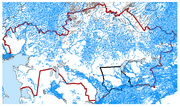
The hydrographic network provided by HydroSHEDS (Figure 3) shows the distance to the nearest water sources, which is critical when choosing areas for grazing. Permanent and temporary watercourses were extracted from the HydroSHEDS dataset and used to generate a distance raster. This raster was then reclassified into suitability scores according to the accessibility of water for livestock. Buffer zones around watercourses were used as one of the factors in the analysis [32].
The presented maps and data collectively create the basis for further MCA of land suitability and the spatial planning of sustainable pastoral land use.
2.1 Determination of criteria weights
The weights of the environmental criteria were determined using the AHP proposed by Saaty. This approach was selected because it allows the relative importance of heterogeneous environmental factors to be assessed through pairwise comparisons and provides a consistency check for the obtained judgments. The weighting procedure was based on two complementary sources: expert assessment and a review of previous studies on pasture suitability, land degradation, and GIS-based multi-criteria evaluation in arid and semi-arid regions.
At the first stage, five criteria were included in the pairwise comparison matrix: slope, soil type, precipitation, proximity to water bodies, and land cover. These criteria were compared according to their relative influence on pasture suitability and ecological limitations in the arid foothill conditions of the Zhambyl region. Greater priority was assigned to slope and soil type, since these factors directly determine erosion risk, water retention capacity, and the stability of pasture ecosystems. Precipitation was ranked as the third most important factor because it reflects moisture availability, while proximity to water bodies was included as a key condition for livestock watering. Land cover received the lowest weight, as it mainly reflects the current state of vegetation and anthropogenic transformation rather than the basic natural potential of the territory.
The normalized priority vector obtained from the AHP matrix produced the following weights: slope — 0.30, soil type — 0.25, precipitation — 0.20, proximity to water bodies — 0.15, and land cover — 0.10. The consistency of the pairwise comparisons was evaluated using the consistency index (CI) and consistency ratio (CR):
$C I=\frac{\lambda_{\max}-n}{n-1}$
$C R=\frac{C I}{R I}$
where, λmax is the maximum eigenvalue of the comparison matrix, n is the number of criteria, and RI is the random index. The obtained CR was below the accepted threshold of 0.10, which indicates an acceptable level of consistency in the weight assignment. Therefore, the resulting weights were considered suitable for further spatial modeling.
The final suitability index was calculated using the WLC method:
$s=\sum_{i=1}^n w_i x_i$
where, s is the final pasture suitability index, wi is the weight of criterion i, and xi is the normalized suitability score of criterion i. In this study, the final raster model was calculated in ArcGIS Pro using the following expression:
$\begin{gathered}S=0.30 X_{\text {slope}}+0.25 X_{\text {soil}}+0.20 X_{\text {precipitation}} +0.15 X_{\text {water}}+0.10 X_{\text {landcover}}\end{gathered}$
where all input raster layers were normalized to a common scale from 0 to 1, with 0 indicating the highest ecological limitation and 1 indicating the most favorable conditions for pasture use.
2.2 Processing, reclassification, and normalization of criterion layers
Before applying the WLC model, all criterion layers were processed and converted into comparable suitability scores. Since the input data had different dimensions and formats, including slope in degrees, precipitation in millimeters, distance to water bodies in meters, and categorical soil and land-cover classes, all layers were transformed into a unified dimensionless scale from 0 to 1. In this study, continuous variables were normalized using a piecewise linear reclassification approach based on threshold values, while categorical variables were reclassified using expert-based suitability scores supported by previous studies on pasture suitability and land degradation in arid regions. Fuzzy logic functions were not used in this study.
The slope layer was derived from the SRTM DEM using the Slope tool in ArcGIS Pro. The resulting raster expressed slope values in degrees. Areas with slopes of 0–5° were considered the most suitable for grazing and assigned a score of 1.0. Slopes of 5–10° were assigned a score of 0.7, slopes of 10–15° were assigned a score of 0.4, and slopes above 15° were assigned a score of 0.2 because of the increased risk of erosion and limited suitability for pasture use.
The precipitation layer was prepared from WorldClim v2 data. Since moisture availability is one of the main limiting factors in arid ecosystems, areas receiving more than 400 mm of annual precipitation were assigned the highest suitability score of 1.0. Areas with 300–400 mm were assigned a score of 0.8, areas with 200–300 mm were assigned a score of 0.6, and areas with less than 200 mm were assigned a score of 0.3.
The proximity to water bodies criterion was processed using the HydroSHEDS hydrographic network. First, permanent and temporary watercourses were extracted and converted into a distance raster using the Euclidean Distance tool. Then, the resulting distance raster was reclassified into suitability scores according to livestock water accessibility. Areas located within 0.5 km of water sources were assigned a score of 1.0, areas at 0.5–1.0 km were assigned 0.8, areas at 1.0–2.0 km were assigned 0.6, areas at 2.0–5.0 km were assigned 0.3, and areas located more than 5.0 km from water sources were assigned 0.1. Thus, the suitability score decreased as the distance from water sources increased.
The soil type layer was obtained from SoilGrids and reclassified according to the physical properties of soils that influence pasture productivity, water retention capacity, and erosion resistance. Loamy and light chestnut soils with better water retention and higher productivity were assigned high suitability scores of 0.8–1.0. Moderately suitable soil types were assigned scores of 0.5–0.7. Sandy, saline, rocky, and poorly developed soils were assigned low scores of 0.1–0.3 because of their low resistance to degradation and limited pasture potential.
The land-cover layer was derived from Sentinel-2 and MODIS-based remote sensing data and was treated separately from soil type. Soil type reflects the basic physical and chemical properties of the substrate, while land cover reflects the current state of vegetation and anthropogenic transformation. Dense natural vegetation and stable grass cover were assigned a score of 1.0. Sparse vegetation was assigned a score of 0.6, degraded or bare soil areas were assigned a score of 0.3, and open sands, built-up areas, and non-pasture surfaces were assigned a score of 0.0.
After reclassification, all raster layers had the same spatial resolution of 30 m, the same coordinate system, and the same suitability scale from 0 to 1. The normalized rasters were then integrated in ArcGIS Pro using Raster Calculator. The operation was performed as a cell-by-cell weighted overlay, where each raster cell value was multiplied by the corresponding AHP-derived weight and then summed to obtain the final pasture suitability index. The resulting continuous raster was subsequently classified into three suitability classes using the Natural Breaks (Jenks) method: low suitability, moderate suitability, and high suitability.
To validate the resulting pasture suitability classification, an independent remote sensing-based verification procedure was planned. NDVI layers derived from Sentinel-2 and MODIS data were used as an auxiliary indicator of vegetation productivity and pasture condition. Stratified random sample points were generated within the three suitability classes: low suitability, moderate suitability, and high suitability. For each class, mean NDVI values were extracted and compared to determine whether areas classified as highly suitable also demonstrated higher vegetation productivity. The expected validation pattern was an increase in NDVI values from low-suitability to high-suitability zones. In addition, where field observations or land-use information were available, they were used to qualitatively verify whether the mapped suitability classes corresponded to actual pasture conditions, vegetation cover, and visible degradation signs. This validation route made it possible to assess the reliability of the MCA-based classification using independent spatial evidence.
The classification rules and weighting coefficients used for the transformation of the criterion layers into suitability scores are summarized in Table 1.
The final raster model was produced in ArcGIS Pro 3.3 using the Raster Calculator tool. The normalized raster layers were combined according to the WLC formula presented above. This procedure generated a continuous suitability index ranging from 0 to 1, where higher values indicated lower ecological limitations and higher suitability for sustainable pasture use. The final raster was then classified into three categories using Natural Breaks (Jenks): low suitability (S < 0.45), moderate suitability (S = 0.45–0.70), and high suitability (S > 0.70).
Thus, the proposed GIS-MCA workflow included the following steps: collection of open spatial data, preprocessing and harmonization of raster layers, derivation of criterion layers, AHP-based weighting, reclassification of raw values into suitability scores, WLC-based raster overlay, and final classification of the suitability index. This sequence ensured the reproducibility of the methodology and made it possible to integrate heterogeneous environmental data into a single spatial model of pasture suitability and ecological limitations.
Table 1. Reclassification rules and weighting coefficients of criteria used in the multi-criteria analysis (MCA) of pastures in the Zhambyl region
|
Criterion |
Weighting Coefficient |
Source Data |
Raw Data / Range |
Suitability Score |
Rationale |
|
Slope |
0.30 |
SRTM DEM |
0–5° |
1.0 |
Optimal conditions for grazing; low erosion risk |
|
Slope |
0.30 |
SRTM DEM |
5–10° |
0.7 |
Moderate limitation due to increasing erosion risk |
|
Slope |
0.30 |
SRTM DEM |
10–15° |
0.4 |
Considerable limitation for pasture use |
|
Slope |
0.30 |
SRTM DEM |
>15° |
0.2 |
High erosion risk and low suitability |
|
Soil type |
0.25 |
SoilGrids |
Loamy / light chestnut soils |
0.8–1.0 |
Higher water retention and pasture productivity |
|
Soil type |
0.25 |
SoilGrids |
Moderately developed soils |
0.5–0.7 |
Moderate water retention and moderate erosion resistance |
|
Soil type |
0.25 |
SoilGrids |
Sandy, saline, rocky soils |
0.1–0.3 |
Low stability and high degradation risk |
|
Precipitation |
0.20 |
WorldClim v2 |
>400 mm |
1.0 |
High moisture availability |
|
Precipitation |
0.20 |
WorldClim v2 |
300–400 mm |
0.8 |
Favorable moisture conditions |
|
Precipitation |
0.20 |
WorldClim v2 |
200–300 mm |
0.6 |
Moderate moisture limitation |
|
Precipitation |
0.20 |
WorldClim v2 |
<200 mm |
0.3 |
Strong moisture deficit |
|
Proximity to water bodies |
0.15 |
HydroSHEDS / Euclidean Distance |
<0.5 km |
1.0 |
Very high accessibility for livestock watering |
|
Proximity to water bodies |
0.15 |
HydroSHEDS / Euclidean Distance |
0.5–1.0 km |
0.8 |
High accessibility |
|
Proximity to water bodies |
0.15 |
HydroSHEDS / Euclidean Distance |
1.0–2.0 km |
0.6 |
Moderate accessibility |
|
Proximity to water bodies |
0.15 |
HydroSHEDS / Euclidean Distance |
2.0–5.0 km |
0.3 |
Limited accessibility |
|
Proximity to water bodies |
0.15 |
HydroSHEDS / Euclidean Distance |
>5.0 km |
0.1 |
Critical distance from water sources |
|
Land cover |
0.10 |
Sentinel-2 / MODIS |
Dense vegetation / stable |
1.0 |
High ecosystem stability and resistance to grazing pressure |
|
Land cover |
0.10 |
Sentinel-2 / MODIS |
Sparse vegetation |
0.6 |
Moderate resistance to anthropogenic load |
|
Land cover |
0.10 |
Sentinel-2 / MODIS |
Bare or degraded soil |
0.3 |
Low vegetation protection and high degradation risk |
|
Land cover |
0.10 |
Sentinel-2 / MODIS |
Open sands / built-up areas / non-pasture surfaces |
0.0 |
Unsuitable for pasture use |
The results of the spatial analysis were presented as thematic maps demonstrating the gradations of ecological limitations. The final map identifies areas with high, medium, and low levels of suitability for pastoral land use. The spatial differentiation of these categories is determined by the combined influence of relief, hydrological conditions, climatic factors, and soil cover properties.
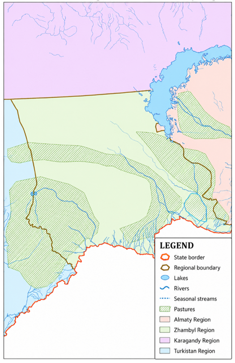
Figure 4 demonstrates the physical and geographical features of the Zhambyl region, which were used as the basis for the analysis.
For the spatial interpretation and visualization of MCA results, a map of the existing pastureland in the Zhambyl region was compiled. This map shows:
•the administrative borders of districts;
•the contours of current pastures;
•major hydrographic objects;
•land use zones potentially subject to ecological limitations.
The compiled map allows us to assess the compliance of the existing distribution of pastures with the natural and environmental conditions of the region. It can be seen from the map that a major share of the pastures is concentrated in the southern and southwestern districts, characterized by favorable relief and access to water resources. The northeastern part of the region has areas with potentially high limitations, which require additional assessment.
The ArcGIS Pro software package, which has extensive capabilities for the visualization, weighing, and combination of spatial data, was actively utilized in the study for the spatial justification and visualization of MCA results. Other deployed tools included Raster Calculator, Reclassify, Weighted Overlay, and Buffer Analysis.
The presented map shows the main grazing lands of the Zhambyl region and the spatial distribution of key environmental criteria — slope, soil type, precipitation, proximity to water sources, and the types of soil cover. The color scale visualizes the level of ecological limitations: from areas with high suitability (the lowest limitations) to areas subject to erosion, drought, and water scarcity.
The spatial analysis conducted in ArcGIS discovered the following patterns:
•The southern and southwestern areas adjacent to the foothills are the most suitable for pastoral use. These territories predominantly have gentle slopes, fertile soils, and moderate precipitation.
•The central part of the region shows an average level of limitations, mainly due to the variable relief and the presence of soil with low water retention capacity.
•The northeastern territories, especially near dry and elevated areas, are characterized by high ecological limitations. These areas are dominated by steep slopes, saline or rocky soils, and limited access to water bodies.
Based on the results of raster recombination (WLC) in the ArcGIS Pro environment, the final fitness map was obtained, clearly showing the priority use areas and territories requiring restoration or protection. This classification provides the basis for science-based solutions to optimize the load on pastures and prevent degradation processes.
Thus, the results allow us to assess the current state of pastures and form spatially justified recommendations on:
•grazing planning;
•the location of water sources and seasonal infrastructure;
•the establishment of protected areas and the implementation of environmental measures.
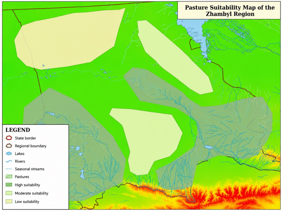
The continuous suitability index obtained from the WLC model ranged from 0 to 1. To convert this continuous raster into discrete suitability classes, the Natural Breaks (Jenks) classification method was applied. The resulting threshold values were used to distinguish three levels of pasture suitability: low suitability (S < 0.45), moderate suitability (S = 0.45–0.70), and high suitability (S > 0.70). These thresholds reflect natural groupings in the spatial distribution of suitability index values and were used for the subsequent calculation of the area share of each class.
Based on these threshold values, the territory of the Zhambyl region was classified into three suitability categories:
•High suitability (S > 0.70; 43% of the total area) — areas characterized by favorable relief, mainly slopes below 5°, relatively productive soils, proximity to water sources, and more stable moisture conditions. These territories have the lowest ecological limitations and are suitable for regulated or rotational grazing.
•Average suitability (S = 0.45–0.70; 38% of the total area) — areas with individual ecological restrictions, such as increased slope, lower soil water retention capacity, or greater distance from water bodies. These territories may be used for seasonal or rotational grazing under controlled pasture load.
•Low suitability (S < 0.45; 19% of the total area) — arid, erosion-prone, saline, rocky, or poorly accessible areas with high ecological limitations. These territories require grazing restrictions, restoration measures, or exclusion from intensive pasture use.
The resulting pasture suitability map is presented in Figure 5.
For the 43% of the territory identified as "Highly suitable" (primarily in the southern and southwestern foothills), management should focus on maintaining productivity and preventing future degradation. This includes implementing carefully planned rotational grazing systems, which have been shown to improve fodder bases and increase productivity [3, 6, 33]. Thoughtful placement of water sources and temporary fencing to subdivide pastures is also critical to ensure even grazing pressure and prevent localized overgrazing around access points [34]. Regular monitoring of vegetation cover and soil health is essential to adapt grazing intensities to seasonal conditions and long-term trends [6, 35].
Areas of "average suitability" (representing 38% of the region, often characterized by variable relief and soils with lower water retention) require more adaptive and flexible grazing strategies [36]. Seasonal or rotational grazing should be implemented with greater caution, perhaps involving longer resting periods or temporary grazing exclusion during vulnerable growth phases or dry spells [36]. This allows vegetation to recover and builds resilience against moderate ecological limitations [37, 38]. Monitoring should be intensified in these zones to detect early signs of degradation and adjust management practices accordingly.
The 19% of the territory classified as "Low suitability" (predominantly in the northeastern parts with steep slopes, saline/rocky soils, and limited water access) should be prioritized for ecological restoration and subjected to strict grazing restrictions or complete exclusion [39]. Specific restoration measures could include:
•Revegetation with native, drought-tolerant plant species to enhance vegetation cover, biomass yield, and soil stability [40, 41]. Identifying suitable local grass species through environmental niche modeling can guide these efforts [41].
•Implementation of soil and water conservation techniques such as terracing [15], contour plowing, and the establishment of water harvesting structures (e.g., surface water collection, spring capture) to improve moisture availability and reduce erosion [37].
•Control and removal of invasive woody species, which can outcompete native forage and reduce biodiversity [42].
•Targeted soil amendments, such as supplementary inputs or organic matter, to improve soil fertility and structure in severely degraded patches where feasible [15].
•Exploring the potential for agroforestry interventions in suitable microclimates to combine tree planting with grazing, thereby enhancing biodiversity, soil health, and resilience [43].
The spatial data allow us to classify pastureland according to the levels of ecological limitations and identify several significant patterns. Comparing the final suitability map with the existing structure of land use, we can see that in the central areas of the Zhambyl region, the actual intensity of pasture use does not match the ecological potential of pasture land. This points to the need to introduce rotational grazing systems and measures to restore degraded land.
The proportion of highly suitable pastureland (43%) in the Zhambyl region is notably positive, suggesting significant potential for sustainable grazing. This contrasts with some studies focusing on cropland suitability in semi-arid conditions, such as that by Tuğaç et al. [13] in Turkey, which identified a lower proportion of highly suitable land for wheat cultivation at 25.7%. Similarly, Özkan et al. [12], also in a semi-arid terrestrial ecosystem, reported a higher percentage of unsuitable land for agriculture (42.7%) compared to the 19% unsuitable pastureland in the current study. However, the results are broadly comparable to cropland suitability assessments in other arid regions, such as Bornuur soum, Mongolia, where Natsagdorj et al. [44] found 46.12% highly suitable and 34.68% moderately suitable for cropland, indicating similar magnitudes of land potential in distinct agricultural contexts. These comparisons highlight that while specific percentages vary based on criteria and target land use, the Zhambyl region appears to possess significant potential for sustainable grazing despite documented degradation in other parts of Kazakhstan.
The climate factor also proved to be highly significant. The southern and southwestern regions, receiving more precipitation, are characterized by stable ecosystems, while the northeastern territories with their arid climate are more susceptible to degradation processes. Remote sensing data (NDVI) confirm differences in the productivity of vegetation cover between these zones, proving climate to be a key hindrance to the uniform use of grazing resources. The identified spatial patterns in the Zhambyl region—with southern and southwestern foothills exhibiting high suitability due to favorable relief, fertile soils, and moderate precipitation, and northeastern territories facing high ecological limitations due to aridity, steep slopes, and poor soils—align well with established geographical influences on land suitability in arid environments. This is consistent with the general understanding of rangeland conditions in Central Asia, where water availability, topography, and soil quality are primary determinants. For instance, studies on rangeland resources in the Bale lowlands of Ethiopia also utilize similar biophysical criteria such as land use/land cover, rainfall, water accessibility, slope, and soil types to delineate suitable areas for livestock production [19].
An equally important factor is the availability of water sources. About 60% of highly suitable pastures are located within 2 km of rivers and lakes, which ensures favorable conditions for grazing. On the contrary, low-usability lands are often more than 5 km away from water bodies, which limits their use without additional spending on the development of infrastructure. Within Kazakhstan, while direct comparative suitability maps with percentages are less common in the literature excerpts, several studies corroborate the pervasive issue of pasture degradation. Lebed et al. reported that about 60% of Kazakhstan's pasturelands are degraded due to unregulated grazing [26]. Kolluru et al. [45] identified the south-central and southeastern parts of Kazakhstan as overstocked, aligning with high livestock density estimates, while northern and northeastern regions were under medium pressure, and central and southwestern regions under low pressure. This further supports the spatial differentiation of pressure on pasturelands within the country. Similarly, studies in the Zhanaarka region of Ulytau Oblast and the Atyrau Region highlight the significant pressure on pasturelands from anthropogenic and climatic factors, leading to environmental degradation, pastureland fragmentation, and reduced productivity [4, 46]. The current study’s findings of concentrated highly suitable areas and significantly limited northeastern zones provide a spatially explicit manifestation of these broader degradation concerns, indicating specific areas where management interventions are most needed to counteract these trends.
Territorial analysis revealed differences between administrative regions: the largest share of highly suitable land is concentrated in the Korday and Merken Districts, while the Baizak and Shu Districts have high-level ecological limitations. This testifies to the need to turn from universal pasture management strategies to localized measures that account for the specifics of local natural conditions. This testifies to the need to turn from universal pasture management strategies to localized measures that account for the specifics of local natural conditions. The high concentration of low-suitability pastures in areas with a dense rural population creates additional social pressure on land resources. This further increases the value of a comprehensive assessment of territories, including both environmental and socio-economic indicators, in the effort to develop balanced management decisions [47].
The adoption of a GIS-MCA framework with WLC, utilizing criteria such as terrain slope, soil type, precipitation, proximity to water sources, and soil cover, reflects a common and effective approach in land suitability assessments globally [13, 15]. Study [13] incorporate similar methodologies, often employing AHP for weighting, which is an alternative to the approach used in the current study. This consistency in methodological approach underscores the robustness and transferability of such frameworks for assessing land suitability in diverse arid and semi-arid contexts. The ability of this study to spatially differentiate pasture suitability and highlight areas requiring specific management interventions contributes directly to the understanding of regional variations in ecological potential. The findings therefore offer a practical tool for informed decision-making in land management, aiming to mitigate degradation and promote sustainable use of pasture resources in the Zhambyl region and potentially other similar dryland environments.
A comprehensive geoecological analysis of the grazing lands of the Zhambyl region was successfully carried out using remote sensing methods, spatial analysis in GIS, and multi-criteria assessment. This study moved beyond merely confirming the method's effectiveness by providing deeper scientific insights into the intricate interplay of environmental factors influencing pasture suitability at a regional scale, particularly within arid ecosystems.
The analysis robustly identified and quantified the leading environmental factors affecting pasture use suitability. Terrain slope (0.30) and soil type (0.25) emerged as the most critical determinants, primarily governing erosion vulnerability and water retention. Following these, precipitation (0.20) significantly shaped local moisture levels, while proximity to water bodies (0.15) and soil cover (0.10) also played important roles in resource accessibility and ecosystem resilience. The spatial differentiation revealed that southern and southwestern regions with gentle slopes, fertile soils, and moderate precipitation are highly suitable, whereas northeastern areas with steep slopes, saline soils, and limited water access face high ecological limitations. The climate factor, particularly precipitation, was found to be highly significant, leading to stable ecosystems in more humid zones and degradation susceptibility in arid northeastern territories. Water availability also proved crucial, with a majority of highly suitable pastures located within 2 km of water sources.
The study's findings facilitated the classification of the region's territory according to ecological limitation levels, identifying zones of low, medium, and high suitability. The analysis performed in ArcGIS revealed that about 40-45% of the territory possesses high potential suitability, offering opportunities for rational and sustainable use. However, approximately a fifth of the region requires pasture use to be restricted or ceased entirely due to high degradation risks.
For applying this methodology in arid regions like Kazakhstan, several key considerations are paramount. The approach effectively addresses data scarcity by integrating diverse open spatial data sources (DEMs, soil/climatic maps, hydrography) to objectively identify vulnerable zones. It emphasizes the critical impact of factors pertinent to water scarcity and erosion, such as terrain slope, soil properties, climate, and water access. The comprehensive adaptation of MCA and WLC methods to the regional conditions of arid ecosystems in Kazakhstan represents a scientific novelty, with the methodology being adaptable to other Central Asian regions sharing similar climatic and landscape conditions. This underscores the necessity of a scientifically grounded and integrated approach to prevent rapid resource depletion and optimize pasture load distribution in these sensitive environments. Thus, this study expands the scientific understanding of ecological limitations in pastoral land use and provides governments, farms, and environmental structures with practical, spatially-informed tools for sustainable land management, grounded in a deeper understanding of regional environmental dynamics.
[1] Tokbergenova, A.A., Zulpykharov, K.B., Kaliyeva, D.M., Esanbekov, M.Y. (2022). Assessment of the current soil-reclamation state of the soils of Myrzashol in the Kazakhstan part (The Hungry Steppe). Polish Journal of Environmental Studies, 32(1): 789-805. https://doi.org/10.15244/pjoes/155087
[2] Juliev, M., Jumaniyazov, I., Togaev, I., et al. (2023). Land degradation in Central Asia: A review of papers from the Scopus database published in English for the period of 2000-2020. E3S Web of Conferences, 462: 03020. https://doi.org/10.1051/e3sconf/202346203020
[3] Yesmagulova, B.Z., Assetova, A.Y., Tassanova, Z.B., Zhildikbaeva, A.N., Molzhigitova, D.K. (2023). Determination of the degradation degree of pasture lands in the West Kazakhstan region based on monitoring using geoinformation technologies. Journal of Ecological Engineering, 24(1): 179-187. https://doi.org/10.12911/22998993/155167
[4] Akhmedenov, K., Sergaliev, N., Makhambetov, M., et al. (2025). Integrated assessment of pasture ecosystem degradation processes in arid zones: A case study of Atyrau Region, Kazakhstan. Sustainability, 17(19): 8869. https://doi.org/10.3390/su17198869
[5] Lebed, L., Qi, J., Heilman, P. (2012). An ecological assessment of pasturelands in the Balkhash area of Kazakhstan with remote sensing and models. Environmental Research Letters, 7(2): 025203. https://doi.org/10.1088/1748-9326/7/2/025203
[6] Nasiyev, B., Karynbayev, A., Khiyasov, M., et al. (2023). Influence of cattle grazing methods on changes in vegetation cover and productivity of pasture lands in the semi-desert zone of Western Kazakhstan. International Journal of Design & Nature and Ecodynamics, 18(4): 767-774. https://doi.org/10.18280/ijdne.180402
[7] Nasiyev, B., Khiyasov, M., Bekkaliyev, A., et al. (2024). Assessing variability of soil quality in Western Kazakhstan: Dynamic effects of grazing practices. International Journal of Design & Nature and Ecodynamics, 19(3): 875-885. https://doi.org/10.18280/ijdne.190317
[8] Intergovernmental Panel on Climate Change (IPCC). Desertification. In Climate Change and Land: IPCC Special Report on Climate Change, Desertification, Land Degradation, Sustainable Land Management, Food Security, and Greenhouse Gas Fluxes in Terrestrial Ecosystems, 2022: 249-344. https://doi.org/10.1017/9781009157988.005
[9] Chen, X., Cui, X., Sun, L., et al. (2024). Dryland social-ecological systems in Central Asia. In Dryland Social-Ecological Systems in Changing Environments, Springer, Singapore, pp. 203-241. https://doi.org/10.1007/978-981-99-9375-8_7
[10] Kairat, A., Nurbekova, L. (2020). Land suitability evaluation for pasture management using GIS-based MCE: A case study of South Kazakhstan. Geospatial Research Letters, 9(2): 68-79. https://doi.org/10.3390/land9020068
[11] Greene, R., Devillers, R., Luther, J.E., Eddy, B.G. (2011). GIS-based multiple-criteria decision analysis. Geography Compass, 5(6): 412-432. https://doi.org/10.1111/j.1749-8198.2011.00431.x
[12] Özkan, B., Dengiz, O., Turan, İ.D. (2020). Site suitability analysis for potential agricultural land with spatial fuzzy multi-criteria decision analysis in regional scale under semi-arid terrestrial ecosystem. Scientific Reports, 10(1): 1-18. https://doi.org/10.1038/s41598-020-79105-4
[13] Tuğaç, M.G., Tercan, A., Torunlar, H., Karakurt, E., Usul, M. (2023). Agricultural land suitability assessment with GIS-based multi-criteria decision analysis and geostatistical approach in semi-arid regions. Soil Studies, 12(1): 15-29. https://doi.org/10.21657/soilst.1328637
[14] Faraslis, I., Dalezios, N.R., Alpanakis, N., et al. (2023). Remotely sensed agroclimatic classification and zoning in water-limited Mediterranean areas towards sustainable agriculture. Remote Sensing, 15(24): 5720. https://doi.org/10.3390/rs15245720
[15] Dey, R., Sharma, S.B., Thakkar, M.G. (2024). Maximising ecological value and assessing land suitability for sustainable grassland management in Asia’s largest tropical grassland, Western India. Scientific Reports, 14(1): 1-20. https://doi.org/10.1038/s41598-024-62775-9
[16] Rihab, R., Gannouni, S., Rebai, N. (2024). A comparative study of different methods of Multi-Criteria Decision Analysis (MCDA) with spatial reference to select of suitable sites for treated wastewater of irrigated perimeters. Sustainable Water Resources Management, 10(4): 1-21. https://doi.org/10.1007/s40899-024-01120-4
[17] Rodríguez-Merino, A., García-Murillo, P., Fernández-Zamudio, R. (2020). Combining multicriteria decision analysis and GIS to assess vulnerability within a protected area: An objective methodology for managing complex and fragile systems. Ecological Indicators, 108: 105738. https://doi.org/10.1016/j.ecolind.2019.105738
[18] Feizizadeh, B., Fathi, S., Gonbad, Z.G., Ghasmei, M., Makki, M. (2023). A multiple geospatial approach for intangible cultural heritage tourism potentiality mapping in Iran. Sustainability, 15(24): 16659. https://doi.org/10.3390/su152416659
[19] Balew, A., Legese, B., Kunbushu, D., et al. (2022). Identification of suitable land for livestock production using GIS-based multicriteria decision analysis and remote sensing in the Bale Lowlands, Ethiopia. International Journal of Ecology, 2022(1): 9585552. https://doi.org/10.1155/2022/9585552
[20] Baatar, B., Tsogt, K. (2021). Assessment of pastureland degradation using GIS and remote sensing techniques in semi-arid regions of Mongolia. Mongolian Journal of Environmental Studies, 27(1): 1-12. https://doi.org/10.5564/mjes.v27i1.1835
[21] Food and Agriculture Organization. (2018). The state of food security and nutrition in the world. FAO, Rome, Italy. https://www.fao.org/interactive/state-of-food-security-nutrition/2018/en/.
[22] Rahman, M.M., Saha, S.K. (2019). GIS-based multi-criteria analysis for land suitability evaluation of sustainable pasture development. Journal of Arid Environments, 168: 103979. https://doi.org/10.1016/j.jaridenv.2019.103979
[23] Abdrakhmanov, T., Zhumanov, M. (2022). Geospatial analysis of pasture degradation in the steppe zones of Kazakhstan. Eurasian Journal of Soil Science, 11(2): 145-154. https://doi.org/10.18393/ejss.123456
[24] Saaty, T.L. (2008). Decision making with the analytic hierarchy process. International Journal of Services Sciences, 1(1): 83. https://doi.org/10.1504/ijssci.2008.017590
[25] Eswaran, H., Lal, R., Reich, P.F. (2019). Land degradation: An overview. Response to Land Degradation, 20-35. https://doi.org/10.1201/9780429187957-4
[26] Tadesse, G., Zeleke, G. (2019). Mapping land suitability for grazing using GIS and AHP techniques in the Ethiopian highlands. Environmental Systems Research, 8(1): 14. https://doi.org/10.1186/s40068-019-0144-7
[27] Chaudhary, A., Agarwal, N., Sharma, R., Ojha, S.P., Kumar, R. (2021). Nadir altimetry Vis-à-Vis swath altimetry: A study in the context of SWOT mission for the Bay of Bengal. Remote Sensing of Environment, 252: 112120. https://doi.org/10.1016/j.rse.2020.112120
[28] Maru, Y.T., McAllister, R.R., Smith, M.S. (2007). Modelling community interactions and social capital dynamics: The case of regional and rural communities of Australia. Agricultural Systems, 92(1-3): 179-200. https://doi.org/10.1016/j.agsy.2006.03.005
[29] Kassawmar, T., Gessesse, B., Lemma, B. (2016). Land suitability analysis for crop production in a semi-arid environment of Ethiopia using GIS and remote sensing. Environmental Management and Sustainable Development, 5(1): 65-81. https://doi.org/10.5296/emsd.v5i1.8694
[30] Fernández, R.J., Busso, C.A. (2015). Grazing management and vegetation dynamics in arid and semi-arid rangelands of Argentina. Arid Land Research and Management, 29(2): 123-138. https://doi.org/10.1080/15324982.2015.1012627
[31] Jiang, X., Song, Z., Xiong, J., Xie, Z. (2014). Can excluding non-insect taxa from stream macroinvertebrate surveys enhance the sensitivity of taxonomic distinctness indices to human disturbance? Ecological Indicators, 41: 175-182. https://doi.org/10.1016/j.ecolind.2014.01.036
[32] Wicke, B., Sikkema, R., Dornburg, V., Faaij, A. (2011). Exploring land use changes and the role of palm oil production in Indonesia and Malaysia. Land Use Policy, 28(1): 193-206. https://doi.org/10.1016/j.landusepol.2010.06.001
[33] Stybayev, G., Zargar, M., Nasiyev, B., Baitelenova, A., Nogayev, A. (2025). Rotational pasture management for ameliorating productivity and feed value of vegetation, soil quality, and sustainability in dry steppe zone. Online Journal of Biological Sciences, 25(1): 209-218. https://doi.org/10.3844/ojbsci.2025.209.218
[34] Gou, X., Tsunekawa, A., Tsubo, M., Peng, F., Cheng, Y. (2024). Abundant resources compensate for the uneven distribution of ungulates in desert grassland. Frontiers in Plant Science, 15: 1421998. https://doi.org/10.3389/fpls.2024.1421998
[35] Adar, S., Paz-Kagan, T., Argaman, E., Dubinin, M.V., Sternberg, M. (2024). Integrating remote sensing and climatological analysis for sustainable forage management in Mediterranean rangelands. https://ssrn.com/abstract=4913832.
[36] Louhaichi, M., Gamoun, M., Ben Salem, F., Belgacem, A.O. (2021). Rangeland biodiversity and climate variability: Supporting the need for flexible grazing management. Sustainability, 13(13): 7124. https://doi.org/10.3390/su13137124
[37] Belhouadjeb, F.A., Boumakhleb, A., Toaiba, A., et al. (2022). The forage plantation program between desertification mitigation and livestock feeding: An economic analysis. Land, 11(6): 948. https://doi.org/10.3390/land11060948
[38] Mudau, H.S., Ravhuhali, K.E., Sipango, N., Mokoboki, H.K., Moyo, B. (2022). Veld restoration strategies in South African semi-arid rangelands. Are there any successes?-A review. Frontiers in Environmental Science, 10: 960345. https://doi.org/10.3389/fenvs.2022.960345
[39] Turnbull, L., Wainwright, J. (2019). From structure to function: Understanding shrub encroachment in drylands using hydrological and sediment connectivity. Ecological Indicators, 98: 608-618. https://doi.org/10.1016/j.ecolind.2018.11.039
[40] Tuffa, S. (2022). Maintaining sustainability and resilience in rangeland ecosystems. Research in Ecology, 4(2): 51-55. https://doi.org/10.30564/re.v4i2.4747
[41] Álvarez-Holguín, A., Morales-Nieto, C.R., Corrales-Lerma, R., et al. (2024). Grass species with potential for rangelands restoration in northern Mexico: An assessment with environmental niche modeling. Scientific Reports, 14(1): 1-13. https://doi.org/10.1038/s41598-024-56918-1
[42] Eschen, R., Bekele, K., Jumanne, Y., et al. (2023). Experimental prosopis management practices and grassland restoration in three Eastern African countries. CABI Agriculture and Bioscience, 4(1): 1-17. https://doi.org/10.1186/s43170-023-00163-5
[43] de Mendonça, G.C., da Costa, L.M., Abdo, M.T.V.N., et al. (2023). Multicriteria spatial model to prioritize degraded areas for landscape restoration through agroforestry. MethodsX, 10: 102052. https://doi.org/10.1016/j.mex.2023.102052
[44] Natsagdorj, E., Renchin, T., De Maeyer, P., Goossens, R., Van de Voorde, T., Darkhijav, B. (2020). A GIS-based multi-criteria analysis on cropland suitability in Bornuur Soum, Mongolia. The International Archives of the Photogrammetry, Remote Sensing and Spatial Information Sciences, XLIII-B4-2, 149-156. https://doi.org/10.5194/isprs-archives-xliii-b4-2020-149-2020
[45] Kolluru, V., John, R., Saraf, S., Chen, J., Hankerson, B., Robinson, S., Kussainova, M., Jain, K. (2023). Gridded livestock density database and spatial trends for Kazakhstan. Scientific Data, 10(1): 1-15. https://doi.org/10.1038/s41597-023-02736-5
[46] Shokparova, D.K., Sirazhitdinova, M., Bissenbayeva, S. B., Patel, N. (2025). Remote sensing and GIS-based land assessment in Zhanaarka region of Ulytau oblast, Kazakhstan. Frontiers in Environmental Science, 13: 1516460. https://doi.org/10.3389/fenvs.2025.1516460
[47] Nandintsetseg, B., Chang, J., Sen, O.L., Reyer, C.P.O., Kong, K., Yetemen, O., Ciais, P., Davaadalai, J. (2024). Future drought risk and adaptation of pastoralism in Eurasian rangelands. Npj Climate and Atmospheric Science, 7(1): 1-14. https://doi.org/10.1038/s41612-024-00624-2