Fajri Ansari | Retno Prayudyaningsih* | Edom Bayau
© 2026 The authors. This article is published by IIETA and is licensed under the CC BY 4.0 license (http://creativecommons.org/licenses/by/4.0/).
OPEN ACCESS
Indonesia is one of the largest emitters of mercury from artisanal and small-scale gold mining (ASGM), which frequently occurs in ecologically sensitive areas. Obi Island, North Maluku, is particularly vulnerable due to its remote location, small size, and high biodiversity. Unsafe mining tailings deposition further intensifies environmental and social risks. This study aimed to assess the extent of mercury contamination around ASGM as a baseline for future rehabilitation and remediation, integrating physical, chemical, and biological approaches. The study area was categorized into six site types: forest, semi-cultivated field, depositional zone, swamp, new mine, and old mine. Disturbed and undisturbed soil samples were collected in triplicate for analyses of chemical and physical properties. Ground-dwelling invertebrates were sampled using pitfall traps, while water samples were collected across the spatial gradient for mercury analysis. Data were analyzed using Analysis of Variance (ANOVA) and Tukey’s HSD. Soil invertebrates were identified, and diversity indices were calculated using the SPADE program. Results indicated that ASGM activities significantly altered soil physicochemical properties and caused severe mercury contamination. Total Hg in soil peaked dramatically at 18.37 mg/L in active mining zones and 18.35 mg/L in downstream swamps, contrasting sharply with the pristine forest background level of 0.18 mg/L. Similarly, surface water analysis revealed substantial mercury loading, reaching a maximum concentration of 0.089 mg/L in the swamp site type. Moreover, distinct differences were observed in the composition and diversity of soil invertebrate orders and families across sampling locations, highlighting the pervasive ecological impact of ASGM on vulnerable island ecosystems.
small island ecosystems, soil physicochemical properties, heavy metal pollution, tailings deposition, pitfall traps, bioreclamation baseline
The use of mercury in artisanal and small-scale gold mining (ASGM) in the separation of gold is one of the largest sources of mercury emissions globally, contributing 37% of mercury emissions to the atmosphere from different anthropogenic sources, which is the highest of all sectors [1]. Around 20% of the global gold supply is sourced from ASGM [2], and the operation has been known to drive deforestation and land degradation [3-5] and negatively impact soil and water quality [6, 7]. As a business that is primarily driven by poverty [8-10], ASGM has been widely proliferating, especially in regions of the Global South where gold is abundantly found, many of which operate as an “informal” mine, or without a license, causing difficulties in controlling mercury usage [11, 12]. In Indonesia, the location of one of the world’s largest gold deposits [13], more than 1200 ASGM hotspots were recorded in 2017 [14]. Indonesia remains one of the largest emitters of mercury originating from ASGMs, despite its plan to cease the use of mercury in ASM by 2018, especially because the increase in domestic mercury supplies has allowed small-scale miners easier access to mercury [15]. Various ASGM sites in Indonesia showed very high levels of mercury contamination, which is significantly higher than the threshold allowed by the Indonesian government, which is 0.3 ppm for mercury in category 2 of hazardous and toxic waste and 144 ppt for ambient water [16, 17]. Mercury from Indonesian ASGM spots pollutes soil [18-21] and water [22, 23], directly and indirectly affecting the ecosystem and the health of the people living in the vicinity [24, 25].
ASGMs in Indonesia are also typically located in ecologically sensitive areas where the ecosystems are mostly pristine and host valuable biodiversity. Obi Island is inherently prone to disturbances because of its small size, remote location, and rich biodiversity [26]. For example, it is the home of the very rare endemic butterfly Obi Island Birdwing Ornithoptera aesacus, which is classified as Vulnerable in the IUCN Red List of Threatened Species due to the habitat’s continuing decline [27]. In addition to hosting more than 300 ASGM pits, the island is also the site for several other valuable minerals, such as Fe, Ni, and Co, all of which have been exploited at both small and large scales [26]. Artisanal gold mining, typically operated by locals using a shallow shaft and traditional tools for the excavation, has been taking place since as early as 1995, using the rather conventional extraction method involving a two-stage process of whole-ore mercury amalgamation and cyanidation [28]. Similar to many ASGM hotspots in Indonesia, the unsafe deposition of tailings practiced by Obi’s miners is potentially hazardous to them, their families, and the surrounding environment, either from mercury contamination or other hazardous substances involved in gold processing.
The traditional practice, with a lack of safety standards, as well as improper disposal of tailings, poses a danger to the health of miners and the community living near the mines, especially children, from occupational exposure, mercury inhalation, and the use and consumption of contaminated water and food planted in contaminated soil [9]. Additionally, as a coastal society on a remote island relying on fisheries resources, the Obi inhabitants are also at risk of mercury exposure accumulated through the food chain [29, 30]. Research has shown that ASGM workers and people living near mines have high levels of mercury in their bodies [28, 31]. In addition, deforestation in the hilly area of the island to establish the mining complex had a compounding effect on soil loss due to erosion, and the sloping topography accelerated the contamination’s downstream spread to the coastal village area and the sea. A high level of mercury contamination from ASGM located in a similar setting reaches marine environments [32].
These problems reflect the interconnected vulnerabilities of Obi’s residents: socially, environmentally, economically, and physically. Similar to many other ASGMs in Indonesia, where mining is either the main livelihood or a significant source of income [33], people in Obi Island mainly worked as miners or in mining-related jobs, thus relying heavily on the industry. The island’s remoteness and size intensify its vulnerability to climate change.
However, ASGM mercury risks are severely multiplied within small-island ecosystems due to their limited geographic areas, steep hydrological pathways, and low environmental buffering capacities. These micro-scale environments geographically compress the distance between upland mining pits and sensitive downstream vectors like freshwater streams, mangroves, and marine fisheries. Consequently, heavy rainfall drives rapid, unmitigated transport of unsafe tailings and mobilized mercury directly into local drainage systems. This accelerated land-to-sea transport loop intensifies the contamination of localized food chains and directly threatens endemic biodiversity.
Despite these critical dynamics, integrated empirical data linking localized tailings deposition to broader environmental indicators in small Indonesian island settings remain severely understudied. Therefore, this study assesses the ecological impacts of ASGM tailing practices on Obi Island using physical, chemical, and biological measures. Specifically, we address three critical questions: (1) whether tailing deposition changes soil physicochemical properties across site types; (2) whether mercury spreads across the spatial-hydrological gradient downstream; and (3) whether ground-dwelling invertebrate diversity reflects these localized soil disturbances. This research establishes a vital baseline for risk-based remediation and land-use planning in highly vulnerable small-island settings.
2.1 Study site
Data collection took place in Obi Island (1° 21′ 44.34″ S, 127° 43′ 44.01″ E), South Halmahera, North Maluku Province, Indonesia (Figure 1). Obi is a small island with an area of 2542 km2 located south of the larger Halmahera and roughly midway between Sulawesi and New Guinea. It has an undulating topography, characterized by a rough, mountainous interior, with steep valleys and irregular coastline that only flattens on its eastern shores. Much of the island is consequently unsuitable for dense settlement or intensive agriculture, leaving the presence of humans to encompass the pockets of flat land on the coasts—a limited number of settlements and nutmeg, clove, and coconut plantations, along with the ASGM in the north. The lone exception to this relative sparseness is the large nickel extraction and processing area on the western end of Obi, which covers at least 11,550 ha (4.5% of the island). Owing to the global push for renewables, this mineral-rich area has undergone rapid expansion in recent decades, transforming it into an industrial hub that now dominates the region’s economy.
2.2 Data collection
Data were collected from an ASGM in Anggai Village, the main ASGM location in Obi Island. The study area was systematically divided into six distinct zones based on their specific site types, history, primary disturbance type, and location within the watershed (Table 1). The study sites constitute a contiguous spatial and hydrological gradient from uphill to downstream. The forest is the pristine, elevated baseline control at the highest topography without mining or tailing exposure. Directly below it is the New Mine and Old Mine, active mining zones with high-intensity disturbance, where mechanical excavation and ore-processing complexes are located. The effluents and processing waste from these high-operation centers flow by gravity and via surface runoff during heavy rain. This hydrological transport flows into immediate downstream accumulation sinks, sequentially through the swamp (moderate tailings exposure) and the depositional zone (high-intensity tailings exposure, where sediments accumulate heavily). Finally, the gradient leads to the semi-cultivated field, a low-exposure downstream zone that is periodically inundated by tailings during the rainy season.
Field sampling of soil, ground-dwelling invertebrates, and water matrices was conducted strategically in September 2023. This period fell within the transitional season, characterized by moderate rainfall, averaging 173 mm per month. During the sampling window, the active ore-processing facilities at both the new mine and the old mine were operating at standard production capacities, maintaining continuous tailings discharge into the uphill dumps. Consequently, the downstream swamp and depositional zone were captured under steady-state hydrological conditions, providing a baseline that reflects representative environmental exposure levels prior to peak monsoon-driven flushing events.

Table 1. Site types classification, disturbance regimes, and spatial-hydrological links
|
Type of Site |
Primary Disturbance Regime |
Spatial & Hydrological Context |
Description |
|
Forest |
Control (No Exposure / No Disturbance) |
Located at the highest topography, upstream baseline. |
The naturally vegetated area in the upper part of the research location has never been used for mining activities. |
|
New Mine |
High-Intensity Mining Disturbance (Active Ore Processing) |
Elevated upland center; primary source of downhill effluents. |
Active ore-processing complex using whole-ore amalgamation and cyanidation facilities; in operation since 2005. |
|
Old Mine |
High-Intensity Mining Disturbance (Active Ore Processing) |
Elevated upland center; primary source of downhill effluents. |
Older active ore-processing complex and amalgamation facilities; in operation since 1999. |
|
Swamp |
Moderate Tailings Exposure (Downstream Sink) |
The mid-slope catchment directly receives downhill runoff from mines. |
Downstream area of the tailings dumps, containing trees and shrubs; the soil is waterlogged to semi-solid. |
|
Depositional Zone |
High-Intensity Tailings Exposure (Primary Accumulation Sink) |
Low-lying topographical depression; main trap for mobilized sediment. |
Depositional zone at the downstream of the mine where tailings directly accumulate; sparsely vegetated mostly with shrubs; soil consisting of heavy tailings sediment. |
|
Semi-cultivated Field |
Low/Periodic Tailings Exposure (Distal Downstream) |
Terminal lowland zone; subject to seasonal hydrological transport. |
The distal downstream area is planted with crops interspersed with shrubs, subject to higher tailings deposition primarily during heavy rainfall seasons. |
From each site category, soil samples for the chemical properties analysis were collected from each sampling site in triplicate. Three 20 × 20 m plots were established to mark the sampling locations, and from each plot, five 1‑kg soil subsamples were collected from a depth of up to 20 cm at five points within the plot, namely the four corners and the center [34]. The total subsamples from each plot were then combined, and a composite soil sample was created for laboratory analysis by taking 1 kg of soil from the mixture. To better represent the variation of the site, soil samples from the new mine and old mine were each collected from three different amalgamation facilities, three plots each, and then composited into three samples. Additionally, an undisturbed soil sample was collected from each plot using a ring sampler (48 mm diameter, 54 mm height) to measure soil bulk density. Ground-dwelling invertebrates are used as the biological indicator [35, 36] and were sampled using the pitfall trap method with four replicates per site type plot (six for forest), spaced at least 5 m apart. A transparent plastic cup (8 cm diameter, 12 cm depth) buried flush with the soil contained 50 mL of a freshly prepared alcohol-glycerin solution (9:1 v/v, 70% ethanol and pure glycerin) acting as a killing agent, fixative, and preservative. An elevated plastic plate (10 cm diameter, 5 cm above the opening) protected each trap from rain dilution. Traps were collected after 72 to 96 hours. Because pitfall trapping primarily measures surface activity density, ecological interpretations are strictly restricted to ground-active invertebrates rather than endogeic or full soil mesofauna communities. Water samples for the mercury content analysis were collected from the tailings pond as the water inlet and from the river as the water outlet of the tailings dump. The samples were preserved with nitric acid and stored in a 1500 mL water sample bottle.
Mercury (Hg) concentrations in water and soil samples were determined using Cold Vapor Atomic Absorption Spectroscopy (CV-AAS) at 253.7 nm. Water analysis was conducted at the Fisheries Laboratory, Hasanuddin University, following SNI 6989.78:2019 standards; calibration curves and instrumental quality control were established using CRM Merck Certipur® (Product Code 1.70226.0100) and CRM ERA 514 (Mercury in Water). Soil Hg analysis was conducted at the Soil Laboratory of the Agricultural Assembly and Modernization Agency, Agriculture Ministry, and performed via acid digestion (HNO₃-HCl) in accordance with US EPA Method 7471B/SNI 8911:2020. Method validation and digestion efficiency for the soil matrix were verified using CRM NIST SRM 2710a (Montana Soil), with an acceptable recovery percentage targeted within 90%–110%.
To evaluate the downstream migration of contaminants, water samples were collected across a broad spatial and hydrological gradient covering six primary nodes: (1) active ore-processing complexes at the new mine and (2) old mine (representing direct facility inputs); (3) the waterlogged swamp and (4) the depositional zone (representing immediate tailing accumulation areas); (5) the semi-cultivated field (representing distal downstream areas subject to periodic seasonal inundation); and (6) the main river outlet at the downstream point (representing the final drainage vector). At each of these six points, sampling was performed in triplicate (n = 3) to ensure analytical reliability. For toxicological and regulatory standardization, the analytical results reported in parts per million (ppm) for water were converted to milligrams per liter (mg/L) using the direct density equivalence formula for dilute aqueous solutions, where 1 ppm = 1 mg/L.
2.3 Data analysis
The composite soil samples were taken to a certified laboratory for soil chemistry analysis on selected parameters (pH, organic carbon, total nitrogen, available phosphorus, available potassium, and cation exchange capacity (CEC)). The undisturbed soil samples were analyzed for soil bulk density. The water samples were analyzed for mercury content and pH level. The results were then analyzed using Analysis of Variance (ANOVA) and Tukey’s HSD to determine the differences between the results. Collected specimens of ground-active invertebrates were rinsed with distilled water and preserved in 70% ethanol for laboratory processing. Taxonomic resolution was carried out systematically to the level of Order and Family using standard identification keys for tropical soil macro- and micro-invertebrates. Morphospecies codes based on distinct diagnostic features were assigned within each family to calculate species richness and total abundance. The diversity of ground-dwelling invertebrates was then calculated using the SPADE program.
3.1 Soil chemical and physical properties
The observed soil nutrient levels on Obi Island exhibited distinct patterns across the different site types (Table 2). The organic C content ranged from 0.90% (very low) in the forest to 2.41% (medium) in the depositional zone. Organic C is a reserve of nitrogen and other nutrients required by plants [37]. The decrease in organic C content can be caused by the influence of topography [38]. Forest soil had the lowest carbon content, potentially because of its location; i.e., higher elevation, fairly large slope, and most of its area has experienced changes into semi-cultivated fields, which can result in erosion, lowering the carbon content. According to Singh and Benbi [39], upland areas that experience erosion have significantly less organic C than soils in sedimented areas. The very low level of organic C, which is unexpected for a forest ecosystem undergoing secondary succession, also suggests potential underlying factors, such as degradation from past disturbances, inherent soil properties of the region that limit carbon accumulation, or the specific age and composition of the forest.
Table 2. Soil chemical properties in artisanal and small-scale gold mining (ASGM) of Obi Island, specifically in forest (F), semi-cultivated field (SF), depositional zone (DZ), swamp (S), new mine (NM), and old mine (OM) site types
|
Site Type |
Soil Chemical Properties |
|||||||||||
|
C (%) |
Rating |
Total N (%) |
Rating |
Available P2O5 (ppm) |
Rating |
K (cmol/kg) |
Rating |
CEC (me/100 g) |
Rating |
pH |
Rating |
|
|
F |
0.90a |
Very low |
0.10a |
Low |
8a |
Very low |
0.16a |
Low |
20.52a |
Medium |
5.15a |
Acid |
|
SF |
1.84b |
Low |
0.13a |
Low |
10.80ab |
Low |
0.20a |
Low |
24.23b |
Medium |
6.80b |
Neutral |
|
DZ |
2.41c |
Medium |
0.23c |
Medium |
18.84cd |
Low |
0.37b |
Medium |
25.14b |
High |
7.77bc |
Neutral |
|
S |
2.40c |
Medium |
0.20bc |
Low |
20.58d |
Low |
0.34b |
Medium |
25.50b |
High |
7.52bc |
Neutral |
|
NM |
2.05bc |
Medium |
0.16ab |
Low |
12.53ab |
Low |
0.16a |
Low |
22.82ab |
Medium |
7.03bc |
Neutral |
|
OM |
2.22bc |
Medium |
0.21bc |
Medium |
14.58bc |
Low |
0.22a |
Low |
24.71b |
Medium |
7.29bc |
Neutral |
Specifically, the semi-cultivated field showed a low organic C level of 1.84%, while the new and old mines exhibited medium levels at 2.05% and 2.22%, respectively (Table 2), aligning with the findings that mining disturbances generally lead to topsoil organic matter depletion [41].
The depositional zone and swamp exhibited medium levels of organic C (2.41% and 2.40%, respectively), likely reflecting the accumulation of organic matter in these environments. Waterlogged conditions in swamps and depositional zones can slow down the decomposition of organic material, leading to higher carbon content. Wetlands, in particular, are known for their capacity to accumulate significant amounts of organic matter.
The forest, semi-cultivated field, new mine, and swamp site types showed low total N content, whereas the depositional zone and old mine had medium N levels. Nitrogen fertilization may be necessary to improve soil fertility and crop yield [42], especially in semi-cultivated fields and new mines, which will be used for agriculture in the future. The low total N (0.10%) in the forest was consistent with the potential for naturally nutrient-poor tropical soils, where leaching and rapid nutrient cycling can result in low overall availability. The low level of total N (0.13%) in the semi-cultivated field might be a result of nutrient uptake by cultivated crops and potential losses through leaching or volatilization associated with agricultural practices. The medium level of total N in the depositional zone (0.23%) and the swamp (0.20%) could be attributed to biological nitrogen fixation processes that often occur in such environments or reduced nitrogen losses through leaching due to water saturation. The low to medium levels of total N (0.16% and 0.21%, respectively) in the mining areas also align with the general pattern of nitrogen depletion observed in mined sites.
Available phosphorus (P₂O₅) was very low to low across all site types (Table 2). The availability of phosphate is influenced by pH and the decomposition of organic matter [43]. The low content of P₂O₅ can be overcome by providing P₂O₅ fertilizer. Although absorbed in small amounts by plants, the use of phosphate fertilizers is often carried out using high doses due to the low efficiency of phosphate fertilizers [44].
The very low P₂O₅ (8 ppm) in the forest, along with that of total N, also reflects the inherently nutrient-deficient tropical soils, where leaching and fast nutrient cycling can lead to diminished overall availability. However, the low levels of P₂O₅ in both the depositional zone and swamp (18.84 ppm and 20.58 ppm, respectively) indicate that even with higher organic matter content, the availability of phosphorus remains limited, which is a common characteristic of many tropical soils. The low levels of P₂O₅ in both the new mine (12.53 ppm) and old mine (14.58 ppm) suggest that, on Obi Island, mining activities do not necessarily result in an increase in phosphorus availability, which contrasts with the findings of one Indonesian study that reported higher phosphorus levels in ASGM soils [45]. The low level of P₂O₅ (10.80 ppm) in the semi-cultivated field aligns with the general trend of low phosphorus availability in tropical soils, suggesting that casual farming activities alone were not sufficient to significantly enhance phosphorus levels.
Potassium (K) is an essential macronutrient for plants, playing a vital role in various physiological processes, including photosynthesis, osmotic regulation, and nutrient transport [46], in addition to the maintenance of overall ecosystem health. Forest, semi-cultivated field, new mine, and old mine exhibited low K values, while the depositional zone and swamp types showed medium K values. To address potassium deficiencies in soils, the application of potassium chloride (KCl), potassium nitrate (KNO3), and NPK fertilizers is a common agricultural practice.
The lower potassium levels observed in ASGM on Obi Island, including forest and semi-cultivated fields near the mining area, could be attributed to the physical removal of the topsoil layer, which is typically enriched in potassium and organic matter, during the gold extraction process. This aligns with findings from other tropical regions, such as Ghana, where small-scale mining has been shown to reduce potassium levels in soils [47]. In contrast, the medium potassium levels in the swamp and depositional zone suggest that specific environmental factors in these locations might enhance potassium availability. The swamp environment, characterized by waterlogged conditions and the accumulation of organic matter, could experience the release of potassium as this organic matter decomposes [48]. Similarly, the depositional zone area, potentially receiving nutrient-rich runoff from higher elevations, might benefit from an additional supply of potassium. Considering the geological context of Obi Island, which comprises Mesozoic ultramafic and metamorphic rocks overlain by Tertiary volcanic and sedimentary rocks [49], the inherent potassium content of these parent materials could also play a role in the observed levels, although the provided data does not offer specific details on the potassium content of the underlying geology. The variations in potassium levels across different mining sites on Obi Island underscore the importance of considering site-specific characteristics, including site type history, topography, and local environmental conditions, when assessing the impact of ASGM on soil nutrients.
CEC values were relatively high across all site types, ranging from medium (20.52–24.71 me/100 g) to high (25.14–25.50 me/100 g). This suggests a generally good nutrient retention capacity. CEC is important for soil fertility and plant health because it describes the amount of cations that can be exchanged between the soil and the surrounding solution, the amount of which is influenced by the mineral composition, organic matter content, and soil pH [46]. CEC values that were not much different in former mining areas compared with other areas were also found by Amri et al. [45]. The slightly lower CEC value of forested land may be influenced by soil pH and organic matter, which were lower than in the other site types. The range of CEC from medium to high in the ASGM in Obi Island presents an interesting comparison with the literature. While many studies report a decrease in CEC in mining areas due to loss of organic matter and clay [41]. The medium to high values on Obi Island suggest a potentially different scenario. The forest, semi-cultivated field, new mine, and old mine area all exhibited medium CEC, while the swamp and depositional zone areas show high CEC. These relatively higher values, especially in the swamp and depositional zone, might indicate a higher inherent capacity of these soils to retain nutrients, possibly due to elevated organic matter content, particularly in the swamp, or the presence of specific clay minerals. This contrasts with findings from areas like Côte d'Ivoire and West Sumbawa, Indonesia, where artisanal mining led to lower CEC values [50]. The high CEC value in the swamp and depositional zone on Obi Island could have implications for the retention of both nutrients and contaminants in these environments.
The pH levels ranged from acidic in the forest (5.15) to neutral in the mining-affected areas (6.80–7.77). This is noteworthy as the literature reports both acidification and alkalization in mining areas [51]. The neutral pH observed in the semi-cultivated field, new and old mine, swamp, and depositional zone areas differed from the findings in Burkina Faso, where gold mining resulted in more acidic soils [52]. However, the higher pH of ASGM in Obi Island aligns with the finding of Shrestha and Lal [53] that stated mining activities or land use changes are increasing soil pH, potentially due to the exposure of base-rich subsoil. The acidic pH in the forest, which serves as a control site, might represent the natural soil condition of the area, possibly influenced by factors like high rainfall leading to leaching of basic cations [54]. The predominantly neutral pH in the mining areas on Obi Island is interesting, especially given that acid mine drainage is a common concern in gold mining regions. This could suggest a lack of significant sulfide mineralization in the mined areas of Obi Island or the presence of natural buffering capacities within the soil [52].
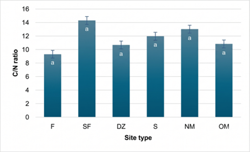
The C/N ratios observed in this study (ranging from 9.33 to 14.33) present a complex picture when compared to existing literature on ASGM-affected soils (Figure 2). Some research indicates that gold mining areas tend to exhibit higher C/N ratios compared to agricultural lands [55]. This contrasts with the finding in the current study, where the semi-cultivated field, representing agricultural land use, displayed the highest C/N ratio. However, other studies on reclaimed mining soils have reported highly variable C/N ratios, ranging from 9.31 to as high as 115.56 [56], suggesting that mining activities can indeed significantly alter this ratio depending on various factors such as the age of the mine, reclamation efforts, and surrounding vegetation. The C/N ratio is a critical factor influencing SOM mineralization and microbial activity within mining ecosystems [57], and the variability observed across different studies highlights the site-specific nature of ASGM impacts on soil biogeochemistry. The specific mining techniques employed on Obi Island, which may differ from those in other studied regions, along with the duration of mining activity at different sites and the characteristics of the recovering vegetation, could all contribute to the observed C/N patterns.
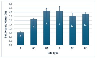
The observed variations in SOM content (%) across the different site types on Obi Island align with the general understanding of ASGM impacts on soil (Figure 3). Existing literature indicates that mining activities typically lead to a loss of soil nutrients, including organic matter [41]. This is consistent with the lower SOM observed in the new and old mines and the forest in this study. Furthermore, deforestation associated with ASGM can exacerbate soil mobilization and erosion, potentially leading to further SOM loss in affected landscapes [58]. The specific context of Obi Island, including the scale and methods of ASGM, the type of vegetation, and the climate, likely contributes to the specific SOM patterns observed.
The significantly lower SOM content (1.56%) in the forest compared with the other site types is a striking finding that contrasts with the general expectation that forest soils typically have higher SOM than agricultural lands. Forest soils, in general, tend to accumulate organic matter from litterfall and root turnover [59]. The unusually low SOM in the forest on Obi Island strongly suggests a significant impact from the surrounding ASGM activities. Deforestation associated with mining can increase soil mobility and erosion [58], potentially leading to the loss of topsoil rich in organic matter from the forest. Additionally, mining activities can result in the destruction of plant cover [50], which would reduce the input of organic matter to the soil, even in adjacent forest areas. It is also possible that the forest on Obi Island is still in a relatively early successional stage following past disturbances, and sufficient time has not yet elapsed for substantial organic matter accumulation in the soil. Further investigation into the history and current state of the forest, including the dominant vegetation types and the extent of any indirect impacts from mining, would be beneficial to fully understand this observation.
The high SOM content observed in the swamp (4.14%) and depositional zone (4.15%), with no significant difference between them, is consistent with the ecological characteristics of these types of environments. Wetland ecosystems like swamps are known to accumulate high levels of organic matter due to the slow rates of decomposition under waterlogged and anaerobic conditions [60]. The limited oxygen availability in saturated soils hinders the activity of decomposer microorganisms, leading to the buildup of undecomposed and partially decomposed organic material. Similarly, the depositional zone, which was located in topographic depressions, can receive runoff and sediments from upslope, which may contain significant amounts of organic matter, leading to its accumulation in these lower-lying areas. The hydrological conditions in both the swamp and depositional zone on Obi Island likely play a crucial role in the preservation of organic matter. Furthermore, it is plausible that these lands act as sinks for organic matter eroded from other parts of the landscape affected by mining, contributing to their higher SOM content.
The intermediate SOM content observed in the semi-cultivated field (3.17%), new mine (3.53%), and old mine (3.82%) areas likely reflects a balance between disturbance or management practices and processes of organic matter accumulation or loss. In the semi-cultivated field, agricultural practices such as the addition of organic fertilizers or compost can contribute to SOM, while cultivation and harvesting might lead to its loss or decomposition. The SOM content in the new mine is expected to be relatively low due to the removal of topsoil and vegetation during mining activities [55]. However, the slightly higher SOM in the old mine compared to the new mine suggests a degree of natural recovery over time. Natural revegetation, the accumulation of litterfall, and the gradual development of soil microbial communities can contribute to the increase in SOM in abandoned mining areas. The fact that the SOM in the mining areas is lower than in the swamp and depositional zone, but not necessarily lower than in the semi-cultivated field, indicates that while mining has a negative impact on SOM, other land use practices and environmental factors also play a significant role in shaping SOM content across the landscape.
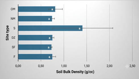
The soil bulk density values provided for the mining areas on Obi Island (old mine 0.81 g/cc and new mine 0.74 g/cc) were notably lower than the range of values reported in several Indonesian studies for areas affected by ASGM, which typically fall between 1.36 and 1.9 g/cc (Figure 4) [61]. This difference suggests that the dominant impact of mining activities on Obi Island, at least in the sampled locations, might be a loosening of the soil structure rather than significant compaction. This could be attributed to the specific techniques employed in ASGM on the island, potentially involving manual excavation and the removal of denser subsoil materials, leaving behind a less compact surface layer.
The bulk density measured in the forest on Obi Island (0.75 g/cc) was also lower than the generalized value of approximately 1.4 g/cm³ often associated with forest soils due to their high organic matter content and macroporosity [62]. It was also lower than the bulk density of 1.21 g/cm³ reported for a control forest site in a Nigerian study [63]. This relatively low bulk density in the Obi Island Forest might indicate a less developed soil profile, a lower clay content, or a different type of forest ecosystem compared to those represented in the literature.
The bulk density values for the depositional zone (0.75 g/cc) and semi-cultivated fields (0.73 g/cc) on Obi Island were also relatively low when compared to the bulk density of 1.2 g/cm³ found in a control agricultural area in an Indonesian study [55]. However, these values were closer to the bulk density of 0.59 g/cm³ reported for a Franklin Garden that had a history of compost addition [64]. This comparison suggests that the depositional zone and semi-cultivated field soils on Obi Island might have a higher organic matter content or be less compacted than typical agricultural soils in other regions.
The soil bulk density for the swamp area (1.41 g/cc) falls within the range reported for some waterlogged salt marsh soils, where bulk density exceeding 1.6 g/cm³ is considered limiting for root growth [65]. It was higher than the values observed in the semi-cultivated fields and the forest on Obi Island, but lower than the high bulk density reported in some mining areas. The interpretation of this value requires consideration of the specific characteristics of the swamp environment on Obi Island, including its organic matter content, water saturation levels, and potential sediment inputs from nearby mining activities.
3.2 Mercury contamination
3.2.1 Soil mercury contamination
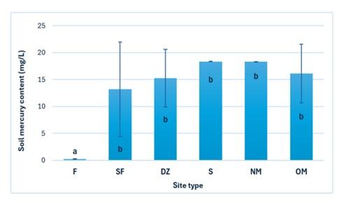
The present study on Obi Island, North Maluku, revealed a significant variation in mercury concentrations across different site types affected by ASGM (Figure 5). The lowest mercury concentration was observed in the forest soil, with a level of 0.18 mg/L. Significantly higher concentrations were found in the semi-cultivated field, depositional zone, swamp, new mine, and old mine area, with values of 13.20 mg/L, 15.28 mg/L, 18.35 mg/L, 18.37 mg/L, and 16.13 mg/L, respectively. This statistically significant variation underscores the impact of ASGM activities on soil mercury levels in the affected areas, with the relatively undisturbed forest exhibiting baseline levels while areas directly or indirectly involved in mining showing substantial enrichment. This finding also clearly demonstrates significant mercury contamination in the soil of most areas in and near the ASGM of Obi Island associated with mining activities, likely from gold amalgamation processes.
The mercury concentrations identified in the contaminated site types on Obi Island (13.20 mg/L to 18.37 mg/L) were generally lower than the most extreme levels documented in other Indonesian ASGM regions such as Bombana (up to 2500 mg/L) [21], Pangkep (up to 223.47 mg/L) [66], parts of West Lombok (up to 8363.64 mg/L) [67], and Buru Island (up to 825 mg/L) [68]. However, these levels on Obi Island were significantly elevated when compared to the background concentration observed in the forest (0.18 mg/L) and fall within the range reported in areas like Sukabumi (27.28 ppm) [69] and Kulon Progo (0.30 to 22.51 mg/mL) [70]. The relatively lower mercury levels on Obi Island might be attributable to a combination of factors, including the scale and duration of mining operations, the specific gold extraction techniques employed, the geological characteristics of the ore deposits in the area, or potentially more effective (though still likely inadequate) waste management practices compared to the most heavily contaminated sites documented in the literature.
3.2.2 Mercury contamination in water bodies
There were elevated levels of mercury found in water (Table 3), particularly in the depositional zone and the old mine. The presence of old and new mines suggests a direct link between mining activities and mercury contamination. The lower mercury levels in the downstream area might indicate that the contamination is being diluted or dispersed as it moves downstream. Related to variability in mercury concentrations, the data show a significant variation in mercury levels across different locations, highlighting the uneven distribution of the pollutant.
Table 3. Mercury contamination and pH level of the water body near artisanal and small-scale gold mining (ASGM) in Obi Island
|
Site Type |
Hg (mg/L) |
pH |
|
New mine |
0.020 |
8.0 |
|
Old mine |
0.028 |
8.5 |
|
Swamp |
0.089 |
8.3 |
|
Depositional zone |
0.063 |
10 |
|
Semi-cultivated field |
0.012 |
7.2 |
|
Downstream |
0.011 |
7.1 |
The results of mercury concentration measurements in surface water have an average range of <0.001-0.002 mg/L, while the mercury concentration in water at a depth of 5 meters ranges from <0.001-0.012 mg/L [71]. High mercury levels in water and soil can pose serious risks to both human health and the environment. Mercury can contaminate water sources, enter the food chain through plants and animals, and cause adverse health effects. Mercury can disrupt ecosystem functions, harm biodiversity, and reduce soil fertility. If the contaminated soil is used for agriculture or gardening, it can pose a direct health risk to local communities through the consumption of contaminated food.
3.3 Ground-dwelling invertebrates
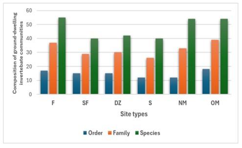
Soil fauna diversity is widely recognized as a useful indicator of habitat quality and ecological recovery in disturbed ecosystems [72, 73]. The data showed that the forest that has not experienced gold mining activities has the highest mesofauna species richness (55 species), but the value was only slightly different from both mining locations, both new and old mines (54 species; Figure 6). However, differences were found in the number of orders and families in the three locations, where forests and old mines have similar numbers of orders and families (17 orders and 37 families in forests, 18 orders and 39 families in old mines), while new mines have relatively fewer orders and families, namely 12 orders and 33 families. In this case, the mesofauna in the old mine may have undergone succession over time, so it will be similar to the initial condition, which is assumed to be similar to forest conditions, as commonly observed in post-mining restoration ecosystems [74, 75]. Meanwhile, mesofauna in the new mines was still disturbed and had not adapted to mining activities, so its diversity was still in a lower position than in forests and old mines. Not significantly different between forest and mining might be due to the type of mining that uses a closed mining system. ASGM mining uses tunnel excavations to extract mining materials, so that there are no significant changes in the top horizon of the soil.
The three locations affected by tailings waste, namely semi-cultivated fields, swamps, and depositional zones, have taxa richness equivalent to a range of 40–42 species, 26–30 families, and 12–15 orders. The species richness of the three locations was relatively much lower compared to the taxon richness of forests and mines. This is an indication that although the location where the tailings waste is dumped has experienced a decline in quality as a mesofauna habitat, this location can still be inhabited by mesofauna with relatively high diversity.
To fully characterize structural shifts within the ground-dwelling invertebrate communities, multiple alpha diversity metrics were calculated using the SPADE program (Table 4). The pristine forest (F) exhibited the highest ecosystem complexity and evenness, supported by the highest Shannon-Wiener index (H' = 3.62) and a remarkably low Simpson dominance index (D = 0.04). In contrast, the lowest diversity levels and highest dominance indices were recorded in heavy-tailing accumulation sinks, specifically the depositional zone (DZ; H' = 2.45, D = 0.18) and the waterlogged swamp (S; H' = 2.61, D = 0.14), signaling severe habitat stress that constrains invertebrate viability to a few resilient taxa.
Table 4. Diversity indices of ground-dwelling invertebrate communities across different site types
|
Site Type |
Species Richness (S) |
Chao1 Index |
Shannon-Wiener Index (H′) |
Simpson Index (D) |
|
Forest (F) |
55 |
55.2 |
3.62 |
0.04 |
|
Semi-cultivated Field (SF) |
40 |
41.5 |
2.94 |
0.08 |
|
Swamp (S) |
40 |
42.1 |
2.61 |
0.14 |
|
Depositional Zone (DZ) |
42 |
43.8 |
2.45 |
0.18 |
|
New Mine (NM) |
54 |
54.8 |
2.88 |
0.12 |
|
Old Mine (OM) |
54 |
54.5 |
3.24 |
0.06 |
Interestingly, while estimated species richness (Chao1) remained high in active mining environments due to the influx of disturbance-tolerant edge species, the Shannon index revealed a clear successional gradient between the mining sites. The stabilized old mine (OM; H' = 3.24, D = 0.06) displayed higher diversity and lower community dominance compared to the new mine (NM; H' = 2.88, D = 0.12). This divergence verifies that long-term soil stabilization and organic matter recovery in older operational zones allow a more balanced and diverse macroinvertebrate assemblage to re-establish over time.
Spatial analysis revealed distinct shifts in invertebrate taxonomic composition across site types zones (Table A1). The complete checklist of family-level abundance and morphospecies richness per site is provided in Table A1. The entire community was characterized by a severe hyper-dominance of formicidae (Hymenoptera), accounting for nearly 48% of total captured individuals (1,091 individuals across 113 morphospecies). This dominance peaked in the high-disturbance new mine (NM) zone, where ants comprised over 70% of the local assemblage.
Downstream tailing transport pathways caused marked structural compressions. The depositional zone (DZ) recorded the lowest abundance (171 individuals), where sensitive forest decomposers were replaced by resilient generalists like crickets (Gryllidae) and earwigs (Anisolabididae). Conversely, the waterlogged swamp (S) favored springtails (Collembola: Entomobryidae) and ground spiders (Gnaphosidae). Signs of multi-trophic recovery emerged in the stabilized old mine (OM) with a re-establishment of litter decomposers (Entomobryidae). Meanwhile, the semi-cultivated field (SF) exhibited an ecotone effect, accumulating the highest abundance (513 individuals) and richness (113 species) due to its mosaic gradient (Table A1).
To determine whether these spatial variations resulted in distinct community shifts, a pairwise similarity index was calculated across all habitats (Table 5). In general, the similarity of ground-dwelling invertebrate species composition remained at an intermediate level, with an average pairwise similarity of 0.470 and a community Morisita-Horn index of 0.377. The high similarity index between the forest and the new mine (0.60) reflects an acute transitional shift, where forest generalists temporarily persist in the newly cleared margins before specialized taxa are extirpated. Conversely, the divergence between old mine and new mine (0.39) proves a unidirectional successional recovery path as the older operational habitat stabilizes.
Table 5. Similarity of ground-dwelling invertebrate composition in various habitats
|
Site Type |
Forest |
Semi-Cultivated Field |
Swamp |
Depositional Zone |
New Mine |
Old Mine |
|
Forest |
|
0.42 |
0.49 |
0.49 |
0.60 |
0.48 |
|
Semi-cultivated field |
|
|
0.49 |
0.48 |
0.47 |
0.43 |
|
Swamp |
|
|
|
0.51 |
0.36 |
0.50 |
|
Depositional zone |
|
|
|
|
0.49 |
0.45 |
|
New mine |
|
|
|
|
|
0.39 |
|
Old mine |
|
|
|
|
|
|
To properly interpret the ecological impacts of ASGM on the biotic community, a careful distinction must be made between absolute taxonomic richness, compositional similarity, and the trajectory of successional recovery. The data reveal that while the forest and the new mine share the highest pairwise compositional similarity index (0.60; Table 5), this does not imply that the active mining site is undisturbed or ecologically stable. Rather, this high similarity indicates an acute "compositional shift" or immediate successional transition. When a pristine forest canopy is cleared for new mining operations, opportunistic and highly mobile surface-active species from the surrounding forest temporarily persist or invade the open area, creating high species turnover, but a mathematically high overlap index relative to the forest baseline before specialized forest taxa are completely extirpated. Conversely, the Old Mine, which has been operational since 1999, demonstrates a distinct pathway of long-term successional recovery. The old mine exhibits low compositional similarity to the new mine (0.39; Table 4), proving that as mining sites age, their micro-habitats diverge completely from active processing complexes. Over time, the structural recovery of SOM (3.82%; Figure 3) and stabilization of neutral pH (7.29; Table 2) in the Old Mine allowed a secondary succession of specialized, stable invertebrate families to re-colonize the area. This structural shift causes the community composition to move unidirectionally away from both the heavily disturbed New Mine and the initial baseline composition of the Forest. Therefore, while the New Mine retains high richness due to temporary influxes of edge-tolerant forest generalists, the Old Mine represents a more advanced, albeit altered, functional ecosystem recovery status.
3.3 Practical implications for land use and risk-based planning
The results of the study indicate that the physical and chemical characteristics of the soil in various locations of former ASGM activities were in suboptimal conditions to support agricultural activities. However, several low soil chemical parameters can be improved through agronomic interventions, especially through the application of appropriate fertilizers, to optimize the agricultural potential of the land.
In terms of ground-dwelling invertebrate biodiversity, no significant differences were found between forested land and former ASGM land. The abundance and biodiversity of mesofauna showed relatively similar levels in both types of land. This indicates that, from a biotic and soil chemical perspective, former mining areas still have the potential to be developed into agricultural land, as long as appropriate management is carried out.
However, one of the crucial findings of this study is the strong indication of mercury contamination in former ASGM land, due to the use of this heavy metal in the gold extraction process. Mercury-contaminated soil, if used as agricultural land, might cause plants to absorb the heavy metal. For example, research by Tang et al. [76] showed mercury accumulation in rice plants planted on contaminated soil. Nevertheless, the research results by Santoso and Wahyudi [77] indicate that not all plants cultivated in ex-mining land show mercury content that exceeds the safe threshold. In addition, Moreno et al. [78] also reported that mercury is not easily absorbed by plants in most contaminated soils or mine tailings. The variability of a plant's ability to accumulate mercury highly depends on plant species and environmental conditions, including soil and atmospheric characteristics [79, 80]. The level of contamination in food crops is determined by the interaction between the physiological ability of the plant and the level of contamination of the surrounding soil/water.
Former mining areas in Indonesia, in several regions, are mainly used as agricultural land and for several other land uses. Former gold mining land is used as rice fields [81-83], the community even wants former mining land to be used as agricultural land, fish farming, reservoirs, and tourist attractions [84], and several former mining areas are considered to have the potential as land for fish farming, agriculture, and plantations [85]. This shows that there is a request and effort by the community to utilize post-mining land productively. Public environmental awareness, particularly farmers' concern and awareness of the need for caution in using ex-mining land, is likely to increase if soil pollution becomes a serious problem [86].
At the study site, both new and old mining areas are located on hillsides above the disposal zone and adjacent swamps. Consequently, surface runoff from the mining areas flows downslope, with part of it accumulating in the disposal zone and swamp. Sediment generated by erosion and residues from amalgamation processes are also transported and deposited in these lowland areas. Field observations showed that local communities have cultivated parts of the disposal zone and swamp by planting crops such as banana, guava, coconut, nutmeg, and other economically valuable species.
Despite the increasing use of former ASGM land for agricultural purposes, most previous studies have focused primarily on changes in the physical and chemical properties of the soil, whereas the implications of mercury contamination for agricultural production and food safety remain relatively understudied. Therefore, the conversion of former ASGM land to agricultural use should be undertaken cautiously and supported by comprehensive scientific assessments of mercury contamination risks.
Although various methods for remediation of mercury-contaminated soil have been developed, such as thermal desorption and phytoextraction, their application on a large scale still faces obstacles, both in terms of economics and environmental impacts. The available technologies generally require high costs and a long time to achieve significant results, so they cannot meet the needs of the community in the short to medium term. As a result, conventional remediation methods are less attractive to landowners because they are economically inefficient. This comprehensive issue requires the participation of the government, the polluting parties, and third-party management companies to discover simple, cheaper, and more efficient regulations and methods in the future [87].
Given that total soil mercury concentrations reach critically elevated levels of 13.20–18.37 mg/L across several affected zones, any immediate agricultural development or food crop cultivation in these areas is highly premature and poses severe ecotoxicological risks. These documented concentrations vastly exceed international thresholds for agricultural soil safety. Because direct crop mercury uptake and bioaccumulation factors were not explicitly quantified in this study, the immediate use of these lands for farming is strictly discouraged. Instead of active production, these highly contaminated sites must be restricted to non-food vegetation baselines. Future follow-up work is strictly required to establish safe land-use boundaries. This includes comprehensive greenhouse and field trials to evaluate crop-specific mercury uptake rates and bioaccumulation coefficients, and to screen non-edible, heavy-metal-tolerant hyperaccumulators. Until rigorous tissue-analysis protocols confirm that heavy-metal translocation into edible plant parts remains safely below permissible consumer limits, agricultural planning on Obi Island must prioritize strict zoning, risk-based exclusion, and targeted microbial or organic pot-based bioreclamation to stabilize the soil matrix.
To bridge the gap between high contamination and long-term land restoration, deploying targeted microbial bioremediation strategies offers a viable pathway to accelerate mercury stabilization. Given the adaptation of indigenous microbiomes to high-stress island environments, isolating local mercury-resistant bacteria (such as those possessing the merA gene for volatilizing Hg²⁺ into less toxic Hg⁰) or utilizing arbuscular mycorrhizal fungi (AMF) to sequester heavy metals within the root-rhizosphere boundary (phytostabilization) can significantly mitigate downstream migration. Integrating these specialized microbial inoculants into organic-pot technologies or native non-food vegetative covers could physically and biologically lock contaminants in place. Consequently, piloting site-specific microbial-assisted remediation trials stands as a critical, high-priority avenue for future follow-up research to safely restore the ecological integrity of Obi Island's degraded landscape.
This study demonstrates that ASGM activities and unsafe tailings disposal on Obi Island have significantly altered the local ecosystem. The empirical results show that the mining-affected areas exhibit severe mercury contamination, with total soil Hg concentrations reaching a maximum of 18.37 mg/L in active mining zones and surface water Hg reaching 0.089 mg/L in downstream swamps, in sharp contrast to the background level of 0.18 mg/L in the pristine forest. In addition to heavy metal loading, soil physicochemical properties have been significantly altered by mining disturbances, with localized increases in pH, available phosphorus, and total nitrogen. Biological indicators also reflect these habitat changes, with communities of ground-dwelling invertebrates showing significant structural changes and high species turnover between undisturbed forest and tailings-affected sites. While these documented concentrations of mercury in soil and water represent critical potential risks to nearby residents, downstream fisheries, and agricultural food chains, further direct exposure assessments are still required. Overall, our results underscore the paramount importance of site-specific, risk-based approaches for the remediation and restoration of ecosystems and for mitigating continued environmental degradation in this vulnerable small-island environment.
FA has participated in the acquisition and analysis of the data, drafting the manuscript, and reviewing the manuscript. RP has contributed to designing the research, acquiring and analyzing the data, drafting the manuscript, obtaining funding, and supervisión. EB has participated in the acquisition and analysis of the data, drafting the manuscript, and reviewing the manuscript.
We would like to thank the National Research and Innovation Agency (BRIN) and the Indonesia Endowment Fund for Education (LPDP) for funding support under the Program Riset dan Inovasi untuk Indonesia Maju (RIIM) Gelombang 3 tahun 2023, Number 12/II.7/HK/2023 (Contract Number B-840/II.7.5/FR.06/5/2023 and B-977/III.5/FR.06.00/5/2023).
Table A1. List of the main taxa of ground-dwelling invertebrates in each site type
|
Taxa (Order/Family) |
Forest (F) |
New Mine (NM) |
Old Mine (OM) |
Swamp (S) |
Depositional Zone (DZ) |
Semi-Cultivated Field (SF) |
Total Indiv. |
Total Spp. |
|
Hymenoptera (Formicidae) |
309 |
324 |
145 |
83 |
45 |
185 |
1091 |
113 |
|
Collembola (Entomobrydae/idae) |
11 |
4 |
62 |
73 |
16 |
111 |
277 |
25 |
|
Orthoptera (Gryllidae) |
2 |
7 |
11 |
28 |
30 |
49 |
127 |
39 |
|
Dermaptera (Anisolabididae) |
37 |
10 |
19 |
32 |
7 |
15 |
120 |
29 |
|
Araneae (Gnaphosidae) |
0 |
9 |
0 |
19 |
8 |
23 |
59 |
14 |
|
Araneae (Corinnidae) |
5 |
9 |
3 |
10 |
2 |
22 |
51 |
24 |
|
Coleoptera (Staphylinidae) |
3 |
16 |
13 |
5 |
3 |
6 |
46 |
25 |
|
Coleoptera (Curculionidae) |
6 |
2 |
7 |
9 |
8 |
11 |
43 |
17 |
|
Araneae (Araneidae) |
0 |
8 |
0 |
2 |
0 |
18 |
28 |
4 |
|
Araneae (Ctenidae) |
2 |
3 |
17 |
0 |
1 |
0 |
23 |
13 |
|
Other Taxa (Combined) |
75 |
49 |
94 |
43 |
49 |
73 |
383 |
195 |
|
Grand Total (Indiv.) |
450 |
461 |
384 |
304 |
171 |
513 |
2283 |
-- |
|
Grand Total (Species) |
100 |
64 |
84 |
65 |
72 |
113 |
-- |
498 |
[1] Global Mercury Assessment 2018. UN Environment Programme. https://www.unep.org/globalmercurypartnership/resources/report/global-mercury-assessment-2018.
[2] Fritz, M.M., McQuilken, J., Collins, N., Weldegiorgis, F. (2018). Global trends in artisanal and small-scale mining (ASM): A review of key numbers and issues. Working Papers hal-02547257.
[3] Ofosu, G., Dittmann, A., Sarpong, D., Botchie, D. (2020). Socio-economic and environmental implications of artisanal and small-scale mining (ASM) on agriculture and livelihoods. Environmental Science & Policy, 106: 210-220. https://doi.org/10.1016/j.envsci.2020.02.005
[4] Caballero Espejo, J., Messinger, M., Román-Dañobeytia, F., Ascorra, C., Fernandez, L.E., Silman, M. (2018). Deforestation and forest degradation due to gold mining in the Peruvian Amazon: A 34-year perspective. Remote Sensing, 10(12): 1903. https://doi.org/10.3390/rs10121903
[5] Quash, Y., Kross, A., Jaeger, J.A. (2024). Assessing the impact of gold mining on forest cover in the Surinamese Amazon from 1997 to 2019: A semi-automated satellite-based approach. Ecological Informatics, 80: 102442. https://doi.org/10.1016/j.ecoinf.2023.102442
[6] Fagariba, C.J., Sumani, J.B.B., Mohammed, A.S. (2024). Artisanal and small-scale gold mining impact on soil and agriculture: Evidence from Upper Denkyira East Municipality, Ghana. European Journal of Environment and Earth Sciences, 5(3): 12-20. https://doi.org/10.24018/ejgeo.2024.5.3.443
[7] Timsina, S., Hardy, N.G., Woodbury, D.J., Ashton, M.S., Cook-Patton, S.C., Pasternack, R., Martin, M.P. (2022). Tropical surface gold mining: A review of ecological impacts and restoration strategies. Land Degradation & Development, 33(18): 3661-3674. https://doi.org/10.1002/ldr.4430
[8] Omotehinse, A.O., Ogunlade, S. (2022). A systematic review of artisanal and small-scale mining: Impacts in alleviating poverty in Africa. SN Social Sciences, 2(10): 197. https://doi.org/10.1007/s43545-022-00517-2
[9] Esdaile, L.J., Chalker, J.M. (2018). The mercury problem in artisanal and small-scale gold mining. Chemistry—A European Journal, 24(27): 6905-6916. https://doi.org/10.1002/chem.201704840
[10] Seccatore, J., Veiga, M., Origliasso, C., Marin, T., De Tomi, G. (2014). An estimation of the artisanal small-scale production of gold in the world. Science of the Total Environment, 496: 662-667. https://doi.org/10.1016/j.scitotenv.2014.05.003
[11] Achina-Obeng, R., Aram, S.A. (2022). Informal artisanal and small-scale gold mining (ASGM) in Ghana: Assessing environmental impacts, reasons for engagement, and mitigation strategies. Resources Policy, 78: 102907. https://doi.org/10.1016/j.resourpol.2022.102907
[12] Castilhos, Z.C., Domingos, L.M.B. (2024). A picture of artisanal and small-scale gold mining (ASGM) in Brazil and its mercury emissions and releases. Environmental Geochemistry and Health, 46(3): 101. https://doi.org/10.1007/s10653-024-01881-z
[13] Thomsen, M. (2017). High sulphidation gold deposits a retrospective summary. https://www.researchgate.net/publication/314183136_High_Sulphidation_Gold_Deposits_A_Retrospective_Summary#fullTextFileContent.
[14] Ismawati, Y., Zaki, K., Septiono, M.A. (2018). Mercury Country Situation Report: Indonesia. Denpasar, Bali.
[15] Spiegel, S.J., Agrawal, S., Mikha, D., et al. (2018). Phasing out mercury? Ecological economics and Indonesia's small-scale gold mining sector. Ecological Economics, 144: 1-11. https://doi.org/10.1016/j.ecolecon.2017.07.025
[16] Government Regulation. (2014). Government Regulation (PP) Number 101 of 2014 concerning Management of Hazardous and Toxic Waste. https://peraturan.bpk.go.id/Details/5555/pp-no-101-tahun-2014.
[17] Minister of Health Regulation Number 57 of 2016: National Action Plan for Controlling Health Impacts of Mercury Exposure 2016-2020. Ministry of Health. https://peraturan.bpk.go.id/Details/114443/permenkes-no-57-tahun-2016.
[18] Mirdat, S., Pata'dungan, Y.S., Isrun, B. (2013). The level of heavy metal of mercury (Hg) in soil of agricultural area around gold mining in Poboya, Palu. Agrotekbis, 1(2): 127-134. https://www.neliti.com/id/publications/242414/status-logam-berat-merkuri-hg-dalam-tanah-pada-kawasan-pengolahan-tambang-emas-d#cite.
[19] Siahaan, B.C., Utami, S.R., Handayanto, E. (2014). Phytoremediation of mercury-contaminated soil using Lindernia crustacea, Digitaria radicosaa, and Cyperus rotundus and their effects on corn growth and production. Jurnal Tanah dan Sumberdaya Lahan, 1(2): 35-51. https://jtsl.ub.ac.id/index.php/jtsl/article/view/111.
[20] Baiq, D.K. (2018). ASGM status in West Nusa Tenggara Province, Indonesia. Journal of Degraded and Mining Lands Management, 5(2): 1077. https://doi.org/10.15243/jdmlm.2018.052.1077
[21] Basri, Sakakibara, M., Sera, K. (2020). Mercury in soil and forage plants from artisanal and small-scale gold mining in the Bombana area, Indonesia. Toxics, 8(1): 15. https://doi.org/10.3390/toxics8010015
[22] Elvince, R., Inoue, T., Tsushima, K., et al. (2008). Assessment of mercury contamination in the Kahayan River, Central Kalimantan, Indonesia. Journal of Water and Environment Technology, 6(2): 103-112. https://doi.org/10.2965/jwet.2008.103
[23] Tomiyasu, T., Kono, Y., Kodamatani, H., Hidayati, N., Rahajoe, J.S. (2013). The distribution of mercury around the small-scale gold mining area along the Cikaniki River, Bogor, Indonesia. Environmental Research, 125: 12-19. https://doi.org/10.1016/j.envres.2013.03.015
[24] Bose-O'Reilly, S., Drasch, G., Beinhoff, C., et al. (2010). Health assessment of artisanal gold miners in Indonesia. Science of the Total Environment, 408(4): 713-725. https://doi.org/10.1016/j.scitotenv.2009.10.070
[25] Gibb, H., O’Leary, K.G. (2014). Mercury exposure and health impacts among individuals in the artisanal and small-scale gold mining community: A comprehensive review. Environmental Health Perspectives, 122(7): 667-672. https://doi.org/10.1289/ehp.1307864
[26] Ivey, J., Laurs, B.M. (2023). Copper minerals in chalcedony from Obi Island, Indonesia. Journal of Gemmology, 38(5): 512. https://doi.org/10.15506/JoG.2023.38.5.512
[27] Bohm, M. (2018). Ornithoptera croesus. The IUCN Red List of Threatened Species 2018: e.T15511A725553. https://doi.org/10.2305/IUCN.UK.2018-1.RLTS.T15511A725553.en
[28] Krisnayanti, B.D., Anderson, C.W., Utomo, W.H., Feng, X., Handayanto, E., Mudarisna, N., Ikram, H. (2012). Assessment of environmental mercury discharge at a four-year-old artisanal gold mining area on Lombok Island, Indonesia. Journal of Environmental Monitoring, 14(10): 2598-2607. https://doi.org/10.1039/c2em30515a
[29] Dambacher, J.M., Brewer, D.T., Dennis, D.M., Macintyre, M., Foale, S. (2007). Qualitative modelling of gold mine impacts on Lihir Island's socioeconomic system and reef-edge fish community. Environmental Science & Technology, 41(2): 555-562. https://doi.org/10.1021/es0610333
[30] Jiménez-Oyola, S., Escobar Segovia, K., García-Martínez, M.J., Ortega, M., Bolonio, D., García-Garizabal, I., Salgado, B. (2021). Human health risk assessment for exposure to potentially toxic elements in polluted rivers in the Ecuadorian Amazon. Water, 13(5): 613. https://doi.org/10.3390/w13050613
[31] Arifin, Y.I., Sakakibara, M., Takakura, S., Jahja, M., Lihawa, F., Sera, K. (2020). Artisanal and small-scale gold mining activities and mercury exposure in Gorontalo Utara Regency, Indonesia. Toxicological & Environmental Chemistry, 102(10): 521-542. https://doi.org/10.1080/02772248.2020.1839074
[32] Male, Y.T., Reichelt-Brushett, A.J., Pocock, M., Nanlohy, A. (2013). Recent mercury contamination from artisanal gold mining on Buru Island, Indonesia–Potential future risks to environmental health and food safety. Marine Pollution Bulletin, 77(1-2): 428-433. https://doi.org/10.1016/j.marpolbul.2013.09.011
[33] Meutia, A.A., Lumowa, R., Sakakibara, M. (2022). Indonesian artisanal and small-scale gold mining—A narrative literature review. International Journal of Environmental Research and Public Health, 19(7): 3955. https://doi.org/10.3390/ijerph19073955
[34] Paetz, A., Wilke, B.M. (2005). Soil sampling and storage. In Monitoring and Assessing Soil Bioremediation, pp. 1-45. https://doi.org/10.1007/3-540-28904-6_1
[35] George, P.B., Keith, A.M., Creer, S., et al. (2017). Evaluation of mesofauna communities as soil quality indicators in a national-level monitoring programme. Soil Biology and Biochemistry, 115: 537-546. https://doi.org/10.1016/j.soilbio.2017.09.022
[36] Mc Guirk, B.G. (2019). Assessing the ecotoxicity of goldmine tailings by utilising earthworms and soil mesofauna as bioindicators. Doctoral dissertation, North-West University (South Africa).
[37] Craswell, E.T., Lefroy, R.D.B. (2001). The role and function of organic matter in tropical soils. Nutrient Cycling in Agroecosystems, 61(1): 7-18. https://doi.org/10.1023/A:1013656024633
[38] Jakšić, S., Ninkov, J., Milić, S., Vasin, J., Živanov, M., Jakšić, D., Komlen, V. (2021). Influence of slope gradient and aspect on soil organic carbon content in the region of Niš, Serbia. Sustainability, 13(15): 8332. https://doi.org/10.3390/su13158332
[39] Singh, P., Benbi, D.K. (2018). Soil organic carbon pool changes in relation to slope position and land-use in Indian lower Himalayas. Catena, 166: 171-180. https://doi.org/10.1016/j.catena.2018.04.006
[40] Hardjowigeno, S. (2012). Soil Science. Akademika Pressindo. https://perpustakaan.bmkg.go.id/buku/ilmu-tanah.
[41] Eludoyin, A.O., Ojo, A.T., Ojo, T.O., Awotoye, O.O. (2017). Effects of artisanal gold mining activities on soil properties in a part of southwestern Nigeria. Cogent Environmental Science, 3(1): 1305650. https://doi.org/10.1080/23311843.2017.1305650
[42] Peng, G.A.O., Zhang, T., Huang, J., Zhang, Z.H., Zhang, H.M. (2023). Improvement of soil fertility and rice yield after long-term application of cow manure combined with inorganic fertilizers. Journal of Integrative Agriculture, 22(7): 2221-2232. https://doi.org/10.1016/j.jia.2023.02.037
[43] Hutagaol, D., Nuraida, F.H. (2022). Phosphate-Solubilizing Microorganisms (A Study on P Availability, Growth, and Production of Lowland Rice) [Mikroorganisme Pelarut Fosfat (Kajian Ketersediaan P, Pertumbuhan dan Produksi Padi sawah)]. Guepedia.
[44] Filho, A.B.C., Luiz Pereira da Silva, A., Mendoza-Cortez, J.W., Barbosa, J.C. (2015). Cauliflower and broccoli productivity as influenced by phosphorus fertilizer doses in a P-rich soil. Australian Journal of Crop Science, 9(8): 709-712.
[45] Amri, F., Hindersah, R., Kurnani, B.R., Sunardi, S., Cahyandito, M.F., Nursyamsi, D. (2020). Physical and chemical natures of post artisanal gold mine area at Kebunlado village of Riau province. Indonesian Mining Journal, 23(1): 9-19. https://doi.org/10.30556/imj.Vol23.No1.2020.1062
[46] Telaumbanua, P.H., Nazara, R.V., Zebua, H.P., et al. (2024). Dasar-Dasar Agronomi. Azzia Karya Bersama.
[47] Asare, D., Ansong, M., Asante, W.A., Kyereh, B. (2024). Impact of different illegal artisanal small-scale mining techniques on soil properties in a major mining landscape in Ghana. Environmental Challenges, 17: 101008. https://doi.org/10.1016/j.envc.2024.101008
[48] Hermis, H., Mulyati, S., Aulia, M.P., Ichwana, I., Simina, S., Arahman, N. (2024). Remediation of remains place gold mining land using boiler ash and sludge from palm oil liquid waste processing. BIO Web of Conferences, 89: 01008. https://doi.org/10.1051/bioconf/20248901008
[49] Agustiyanto, D.A. (1996). The geology and tectonic evolution of the Obi region, eastern Indonesia. University of London, University College London (United Kingdom).
[50] Beda, J.C., Ouattara, J.M.P., Messou, A., Coulibaly, L. (2021). Impacts of artisanal and small-scale gold mining on soils in northern regions of Côte d’Ivoire: Cases of Boundiali, Korhogo and Tengrela. International Journal of Biological and Chemical Sciences, 15(3): 1234-1248. https://doi.org/10.4314/ijbcs.v15i3.28
[51] Léopold, E.N., Sabine, D.D., Philémon, Z.O.Z., Jung, M.C. (2016). Physical and metals impact of traditional gold mining on soils in Kombo-Laka area (Meiganga, Cameroon). International Journal of Geosciences, 7(9): 1102-1121. https://doi.org/10.4236/ijg.2016.79084
[52] Kagambega, N., Sam, U., Ouedraogo, M. (2023). Artisanal mining and soil quality in the Sudano-Sahelian climate: Case of the artisanal mining site of Yimiougou in Burkina Faso, West Africa. Journal of Environmental Protection, 14(1): 1-15. https://doi.org/10.4236/jep.2023.141001
[53] Shrestha, R.K., Lal, R. (2011). Changes in physical and chemical properties of soil after surface mining and reclamation. Geoderma, 161(3-4): 168-176. https://doi.org/10.1016/j.geoderma.2010.12.015
[54] Adekiya, A.O., Oloruntoba, A., Ewulo, B.S., Ogunbode, T., Sangoyomi, T. (2024). Heavy metal pollution in soils near Ilesha gold mining area, Nigeria. The Open Agriculture Journal, 18(1). http://doi.org/10.2174/0118743315290216240123111021
[55] Basir-Cyio, M., Isrun-Baso, M., Nakazawa, K., et al. (2020). The effect of traditional gold mining to land degradation, mercury contamination and decreasing of agricultural productivity. Bulgarian Journal of Agricultural Science, 26(3): 612-621.
[56] Feketeová, Z., Hrabovský, A., Šimkovic, I. (2021). Microbial features indicating the recovery of soil ecosystem strongly affected by mining and ore processing. International Journal of Environmental Research and Public Health, 18(6): 3240. https://doi.org/10.3390/ijerph18063240
[57] Long, Y., Zhang, D., Wu, H., et al. (2024). Patterns and driving mechanisms of soil organic carbon, nitrogen, and phosphorus, and their stoichiometry in limestone mines of Anhui Province, China. Forests, 15(11): 1969. https://doi.org/10.3390/f15111969
[58] Diringer, S.E., Berky, A.J., Marani, M., et al. (2019). Deforestation due to artisanal and small-scale gold mining exacerbates soil and mercury mobilization in Madre de Dios, Peru. Environmental Science & Technology, 54(1): 286-296. https://doi.org/10.1021/acs.est.9b06620
[59] Osman, K.T. (2013). Organic matter of forest soils. In Forest Soils: Properties and Management, pp. 63-76. https://doi.org/10.1007/978-3-319-02541-4_4
[60] Miao, G., Li, Y., Shi, C. (2025). Distribution characteristics of soil organic carbon and active carbon components in the peat swamp wetlands of the Altai Mountains, China. Land, 14(4): 670. https://doi.org/10.3390/land14040670
[61] Kusnarta, I.G.M., Suwardji, S., Fahrudin, F., et al. (2024). Effectiveness of different sources of biochar for immobilizing mercury in soil from artisanal and small-scale gold mining areas in Taliwang Village of West Sumbawa Regency, Indonesia. International Journal of Design & Nature and Ecodynamics, 19(5): 1627-1634. https://doi.org/10.18280/ijdne.190516
[62] Parajuli, M., Hiesl, P., Hagan, D., Khanal, P. (2022). Logging Operations and Soil Compaction. Land-Grant Press. https://lgpress.clemson.edu/publication/logging-operations-and-soil-compaction/.
[63] Abiya, S.E., Odiyi, B.O., Ologundudu, F.A., Akinnifesi, O.J., Akadiri, S. (2018). Assessment of heavy metal pollution in a gold mining site in Southwestern Nigeria. Journal of Genetics and Cell Biology, 1(2): 30-35.
[64] McIvor, K., Cogger, C., Brown, S. (2012). Effects of biosolids based soil products on soil physical and chemical properties in urban gardens. Compost Science & Utilization, 20(4): 199-206. https://doi.org/10.1080/1065657X.2012.10737049
[65] Salehi Hikouei, I., Kim, S.S., Mishra, D.R. (2021). Machine-learning classification of soil bulk density in salt marsh environments. Sensors, 21(13): 4408. https://doi.org/10.3390/s21134408
[66] Astuti, R.D.P., Mallongi, A., Rauf, A.U. (2021). Risk identification of Hg and Pb in soil: A case study from Pangkep Regency, Indonesia. Soil Science Annual, 72(1): 1-15. https://doi.org/10.37501/soilsa/135394
[67] Suhadi, S., Sueb, S., Muliya, B.K., Ashoffi, A.M. (2021). A pollution of mercury and cyanide soils and plants in surrounding in the artisanal and small-scale gold mining (ASGM) at Sekotong District, West Lombok, West Nusa Tenggara. Biological Environment and Pollution, 1(1): 30-37.
[68] Yuliyanti, A., Aminuddin, A. (2023). Mercury Contamination in Artisanal Gold Mining Sites in Indonesia and the Remediation. EAI: Gent, Belgium.
[69] Nuryanty, C.D., Riani, E., Abidin, Z., Sutjahjo, S.H., Riyadi, A. (2024). Mercury contamination from artisanal small-scale gold mining activities in Simpenan district, Sukabumi regency, West Java, Indonesia. Asian Journal of Water, Environment and Pollution, 21(4): 83-89. https://doi.org/10.3233/AJW240049
[70] Rachman, R.M., Ngii, E., Sya’ban, A.R. (2021). Investigation of the spread of mercury in the land around the waste storage ponds in the Kulon Progo traditional gold mine. Journal of Degraded and Mining Lands Management, 8(4): 2911. https://doi.org/10.15243/jdmlm.2021.084.2911
[71] Barus, B.S. (2017). Analysis of the heavy metal content of cadmium (Cd) and mercury (Hg) in water and sediment in the waters of the Banyuasin River estuary. Maspari Journal, 9(1): 69-76. https://www.neliti.com/publications/152131/analisis-kandungan-logam-berat-kadmium-cd-dan-merkuri-hg-pada-air-dan-sedimen-di.
[72] Ge, B.M., Zhang, D.Z., Cui, J., Zhang, H.B., Zhou, C.L., Tang, B.P. (2014). Biodiversity variations of soil macrofauna communities in forests in a reclaimed coast with different diked history. Pakistan Journal of Zoology, 46(4): 1053-1059.
[73] Sanchez, S.P., Courtney, R., Schmidt, O. (2021). Soil meso-and macrofauna indicators of restoration success in rehabilitated mine sites. In Handbook of Ecological and Ecosystem Engineering, pp. 67-94. https://doi.org/10.1002/9781119678595.ch4
[74] Andrés, P., Mateos, E. (2006). Soil mesofaunal responses to post-mining restoration treatments. Applied Soil Ecology, 33(1): 67-78. https://doi.org/10.1016/j.apsoil.2005.08.007
[75] Dunger, W., Wanner, M., Hauser, H., Hohberg, K., et al. (2001). Development of soil fauna at mine sites during 46 years after afforestation. Pedobiologia, 45(3): 243-271. https://doi.org/10.1078/0031-4056-00083
[76] Tang, Z., Fan, F., Deng, S., Wang, D. (2020). Mercury in rice paddy fields and how does some agricultural activities affect the translocation and transformation of mercury - A critical review. Ecotoxicology and Environmental Safety, 202: 110950. https://doi.org/10.1016/j.ecoenv.2020.110950
[77] Santoso, F.J., Wahyudi, I. (2014). Evaluation of the heavy metal mercury (Hg) content in several food crops and secondary crops around the gold mining processing area in Poboya Village, Palu City. Agrotekbis, 2(2): 138-145. https://www.neliti.com/publications/246784/evaluasi-kandungan-logam-berat-merkuri-hg-pada-beberapa-tanaman-pangan-dan-palaw.
[78] Moreno, F.N., Anderson, C.W., Stewart, R.B., Robinson, B.H. (2004). Phytoremediation of mercury-contaminated mine tailings by induced plant-mercury accumulation. Environmental Practice, 6(2): 165-175. https://doi.org/10.1017/S1466046604000274
[79] Lima, F.R.D., Martins, G.C., Silva, A.O., et al. (2019). Critical mercury concentration in tropical soils: Impact on plants and soil biological attributes. Science of the Total Environment, 666: 472-479. https://doi.org/10.1016/j.scitotenv.2019.02.216
[80] Xia, J., Wang, J., Zhang, L., et al. (2020). Screening of native low mercury accumulation crops in a mercury-polluted mining region: Agricultural planning to manage mercury risk in farming communities. Journal of Cleaner Production, 262: 121324. https://doi.org/10.1016/j.jclepro.2020.121324
[81] Chandra, B. (2023). Farmers' motivation for the utilization of paddy fields formerly used for gold mining without permits in Pangkalan Jambu District, Merangin Regency. Bachelor thesis, Universitas Jambi. https://repository.unja.ac.id/id/eprint/53229.
[82] Gusnita, E. (2022). Farmers' attitudes towards the utilization of paddy land from former gold mining works without permit in Pangkalan Jambu District, Merangin Regency. Bachelor thesis, Universitas Jambi. https://repository.unja.ac.id/id/eprint/42083.
[83] Suri, S., Migusnawati, M., Putri, S.D. (2023). Utilization of former gold mine land by using biocar and cow dung fertilizer on the growth of dragon fruit seedlings (Hylocereus undatus L). Jurnal Liefdeagro, 1(2): 51-60. https://doi.org/10.24036/liefde.v1i2.21
[84] Hudiono, H. (2021). Utilization of former illegal gold mining land in Sentajo Raya District, Kuantan Singingi Regency. Bachelor thesis, Universitas Islam Riau. https://repository.uir.ac.id/9256/1/143410192.pdf.
[85] Pernandes, D., Nazori, M., Prasaja, A.S. (2023). Utilization of former gold mining land without a permit (PETI) in Temenggung Village, Limun District, Sarolangun Regency. Nian Tana Sikka: Jurnal ilmiah Mahasiswa, 1(6): 10-27. https://doi.org/10.59603/niantanasikka.v1i6.129
[86] Zhou, Z., Liu, J., Zeng, H., Zhang, T., Chen, X. (2020). How does soil pollution risk perception affect farmers' pro-environmental behavior? The role of income level. Journal of Environmental Management, 270: 110806. https://doi.org/10.1016/j.jenvman.2020.110806
[87] Xu, S., Zhou, Z., Liu, K. (2020). Multi-evolutionary game research on heavy metal pollution control in soil: Based on a third-party perspective. Sustainability, 12(13): 5306. https://doi.org/10.3390/su12135306