Muhammad Nasir![]() | Abubakar Karim*
| Abubakar Karim*![]() | Hairul Basri
| Hairul Basri![]() | Ichwana Ramli
| Ichwana Ramli![]()
© 2026 The authors. This article is published by IIETA and is licensed under the CC BY 4.0 license (http://creativecommons.org/licenses/by/4.0/).
OPEN ACCESS
Soil erosion is a major challenge in tropical volcanic highlands, where steep slopes and fragile soils accelerate land degradation and threaten agricultural sustainability. The Gayo Highlands in Aceh represent a relevant and typical case study due to their distinctive geomorphological characteristics—volcanic soils combined with steep terrain that make the region highly vulnerable to erosion—and the dual role of citronella (Cymbopogon nardus) as both an economically important crop for local communities and a potential conservation plant capable of stabilizing soil. This duality reflects the real conflict between economic development needs and the urgency of soil conservation. This study specifically aims to (i) quantify soil erosion rates and analyze their spatial variation across citronella cultivation areas using the Universal Soil Loss Equation (USLE) validated with field observations, (ii) identify the dominant environmental and management factors driving erosion processes, and (iii) develop and evaluate tiered soil and water conservation technologies—such as contour planting, agroforestry, and terracing—tailored to erosion hazard levels. Results show that most citronella cultivation areas fall within Very Low to Low erosion categories, while approximately 18–22% of the area, particularly LMU32 and LMU43 in Gayo Lues, LMU65 and LMU71 in Bener Meriah, and LMU105 in Central Aceh, are classified as Moderate to Very Severe. Erosion intensity is driven primarily by slope gradient, soil erodibility, vegetation cover, and land management practices, rather than rainfall alone. Notably, Gayo Lues exhibits higher erosion rates despite lower annual rainfall, due to steep terrain and limited conservation efforts. Citronella demonstrates strong potential as a conservation crop, with its dense perennial growth reducing runoff and stabilizing soil. Tiered conservation strategies have proven effective in reducing erosion by up to 80–90%, based on USLE simulations validated through conservation plot observations. The findings provide a robust scientific foundation for spatially targeted conservation planning and highlight practical management priorities to sustain citronella cultivation while enhancing ecosystem resilience in tropical volcanic highlands.
soil conservation, Cymbopogon nardus, erosion control, land conservation, USLE, Gayo Highlands
Soil erosion represents the most prevalent form of land degradation, significantly affecting agricultural productivity and ecosystem sustainability. While erosion is a natural geomorphological process, its intensity is markedly increased by anthropogenic activities such as deforestation, intensive agriculture, and land-use conversion [1]. In tropical regions like Indonesia, high rainfall combined with unsustainable land management practices accelerates soil loss, leading to declining environmental quality and long-term ecological risks [2].
Erosion-driven land degradation reduces critical soil functions, including nutrient retention, infiltration capacity, and water-holding ability, thereby threatening food security and ecological stability [3]. In the absence of effective conservation measures, soil loss is expected to intensify, exacerbating the socio-economic vulnerability of communities reliant on land-based livelihoods. Enhancing land suitability requires targeted interventions to address limiting factors such as temperature, water availability, and erosion risk [4]. Moreover, unsustainable land management practices contribute significantly to the degradation and depletion of land resources, further accelerating erosion processes [5].
One effective approach to land conservation is the use of ground cover vegetation. Grass species such as Citronella (Cymbopogon nardus (L.) Rendle) offer dual benefits—as soil conservation agents and as economically valuable crops through the extraction of citronella essential oil [6]. Citronella has been cultivated across several provinces in Indonesia, notably in Aceh and West Java, with Gayo Lues Regency in Aceh recognized as a key development center. Soil types vary in their capacity to absorb water, and open land lacking vegetation cover is particularly vulnerable to erosion. Such conditions reduce infiltration rates and increase surface runoff, thereby accelerating land degradation [7, 8].
Although the area of Citronella plantations in Gayo Lues had previously declined, recent data indicate a land expansion of 3,867 hectares and land conversion reaching 4,857 hectares over the past decade [9]. Citronella is also utilized as a border crop in cocoa plantations, where it has been shown to reduce erosion by over 40% and enhance soil nutrient content [10]. To predict and manage soil erosion, empirical models such as the Universal Soil Loss Equation (USLE) and its revised version (RUSLE) are widely applied due to their simplicity and reliability. The USLE model estimates annual soil loss based on key parameters including rainfall intensity, soil type, slope gradient, vegetation cover, and land management practices. Biophysical factors such as geology and land use significantly influence erosion dynamics, particularly in highland regions like Gayo Lues, which are characterized by undulating topography and seasonal climatic variations [11-13].
Over the past five years, numerous studies have employed the USLE model to assess erosion hazard levels across diverse landscapes in Indonesia, including river basins and agricultural areas. Yuliana et al. [14] applied the USLE model in the Kerandangan Watershed and identified erosion variability influenced by land cover and slope gradients, recommending vegetative conservation and agroforestry interventions. Similarly, Azmeri et al. [15] conducted erosion modeling in the sub-watersheds of the Keuliling Reservoir, classifying erosion hazard levels as low to moderate. Recent research by Iashania and Syafi'i [16] demonstrates that the USLE and RUSLE models are effective in accurately estimating erosion rates in reclamation and land-clearing areas, while also offering conservation strategies tailored to the biophysical characteristics of the land.
However, studies focusing on Citronella as a conservation-oriented crop remain limited. Susilowati and Syukur [17] investigated the agronomic traits of local Citronella varieties in Cianjur and found that the species exhibits strong physiological adaptation to marginal soils and produces high-quality essential oil. Similarly, Hombegowda et al. [18] reported that Citronella and other aromatic grasses can significantly reduce erosion and enhance soil quality on degraded slopes.
While data on plantation area have been presented, it is equally important to clarify why the Gayo Highlands were chosen as a typical case study. The region possesses distinctive characteristics of tropical volcanic land with steep slopes, making it highly vulnerable to erosion. At the same time, Citronella represents an economically important commodity for local communities and holds strong potential as a conservation crop. This duality reflects a real conflict between economic development needs and the urgency of soil conservation, thereby making the Gayo Highlands a relevant and representative case study.
This study aims to quantify soil erosion rates and analyze their spatial variation across citronella (Cymbopogon nardus) cultivation areas in the Gayo Highlands using the USLE validated with field observations. It further seeks to identify the dominant environmental and management factors—such as slope gradient, soil erodibility, vegetation cover, and conservation practices—that drive erosion processes in tropical highland ecosystems. Finally, the study is designed to develop and evaluate tiered soil and water conservation technologies, including contour planting, agroforestry, and terracing, which are operationally tailored to specific erosion hazard levels to ensure sustainable citronella productivity while maintaining ecological integrity.
2.1 Identification of Land Map Units
This study employs a quantitative descriptive approach and is conducted in the Gayo Highlands, encompassing three administrative regions: Central Aceh Regency, Bener Meriah, and Gayo Lues (Table 1). The research sites include community-managed Citronella cultivation areas and designated agricultural zones, covering both actively planted plots and vacant lands with potential for future cultivation.
Table 1. Description of citronella Land Map Units (LMUs) in the Gayo Highland
|
Regency |
Subdistrict |
Soil |
Slope (%) |
Altitude (m above Sea Level) |
LMU |
Area (ha) |
|
Bener Meriah |
Pintu Rime Gayo |
Latosol |
0 - 8 |
400 - 600 |
58 |
556.15 |
|
Latosol |
8 - 15 |
600 - 800 |
61 |
143.83 |
||
|
Latosol |
25 - 40 |
1.000 - 1 200 |
60 |
1.07 |
||
|
Syiah Utama |
Brown Podsolic |
25 - 40 |
1.000 - 1.200 |
65 |
320.92 |
|
|
Timang Gajah |
Andosol |
0 - 8 |
400 - 600 |
70 |
38.50 |
|
|
Andosol |
8 - 15 |
600 - 800 |
73 |
10.29 |
||
|
Andosol |
15 - 25 |
800 - 1.000 |
71 |
45.76 |
||
|
Bukit |
Brown Podsolic |
25 - 40 |
1.000 - 1.200 |
21 |
17.02 |
|
|
Brown Podsolic |
> 40 |
> 1.200 |
20 |
23.17 |
||
|
Gajah Putih |
Andosol |
0 - 8 |
400 - 600 |
23 |
24.94 |
|
|
Central Aceh |
Silih Nara |
Andosol |
0 - 8 |
400 - 600 |
02 |
2.41 |
|
Andosol |
15 - 25 |
800 - 1.000 |
03 |
99.30 |
||
|
Brown Podsolic |
8 - 15 |
600 - 800 |
10 |
0.59 |
||
|
Brown Podsolic |
15 - 25 |
800 - 1.000 |
08 |
1.80 |
||
|
Rusip Antara |
Brown Podsolic |
25 - 40 |
1.000 - 1.200 |
17 |
288.95 |
|
|
Bintang |
Brown Podsolic |
0 - 8 |
400 - 600 |
100 |
56.97 |
|
|
Brown Podsolic |
25 - 40 |
1.000 - 1.200 |
102 |
384.59 |
||
|
Linge |
Andosol |
8 - 15 |
600 - 800 |
38 |
67.38 |
|
|
YRP |
0 - 8 |
400 - 600 |
45 |
3.98 |
||
|
Bebesan |
Andosol |
> 40 |
> 1.200 |
115 |
137.62 |
|
|
Gayo Lues |
Blangjerango Blangkejeren |
YRP |
15 - 25 |
800 - 1.000 |
05 |
6.83 |
|
Regosol |
0 - 8 |
400 - 600 |
07 |
105.29 |
||
|
Brown Podsolic |
25 - 40 |
1000 - 1.200 |
09 |
460.88 |
||
|
Syiah Utama |
YRP |
0 - 8 |
400 - 600 |
11 |
214.29 |
|
|
Timang Gajah Blangpegayon |
YRP |
> 40 |
> 1.200 |
10 |
22.11 |
|
|
YRP |
0 - 8 |
400 - 600 |
19 |
211.20 |
||
|
Dabun Gelang |
Regosol |
0 - 8 |
400 - 600 |
20 |
101.47 |
YRP: Yellow Red Podsolic
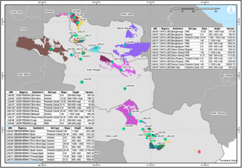
Soil sampling was conducted based on the delineation of Land Map Units (LMUs), which represent homogeneous geographic areas characterized by similar land attributes. The LMUs were delineated through the overlay of thematic maps—specifically soil type, slope gradient, and elevation—within the Gayo Highlands, using the Union function in Geographic Information System (GIS) software with standardized data formats. Each LMU was assigned a unique code or label that reflects its dominant characteristics. This process resulted in the identification of 33 distinct LMUs, as presented in Table 1 and illustrated in Figure 1. The study area was classified into four elevation categories based on altitude: 600–800 meters, 800–1000 meters, 1000–1200 meters, and > 1200 meters above sea level. Slope was grouped into four classes: 0–8%, 8–15%, 15–25%, and 25–40%. The dominant soil types identified in the Gayo Highlands include Andisols, Brown Podzolic soils, and Red-Yellow Podzolic soils. GIS data were utilized to delineate LMUs, which served as the basis for subsequent field observations.
For soil sampling, each LMU was represented by a minimum of three sampling points, which were then composited into a single sample for laboratory analysis. Samples were collected at a depth of 0–20 cm, corresponding to the tillage layer most relevant to erosion processes and crop cultivation. Laboratory analyses included: (i) soil texture determined using the pipette method, (ii) organic matter content measured by the Walkley-Black method, and (iii) soil structure and permeability classified according to USDA standards. These procedures provided the technical basis for calculating the soil erodibility factor (K) in the USLE model.
Data collection involved field surveys and soil sampling, followed by laboratory analysis conducted at the Soil and Plant Research Laboratory, Faculty of Agriculture, Universitas Syiah Kuala. This map illustrates the spatial distribution of land units characterized by variations in soil type, topography, and slope, which influence the suitability and productivity of Citronella cultivation. Green symbols indicate field observation points used for soil and vegetation data collection. The LMUs map serves as a foundational reference for erosion hazard assessment and the formulation of soil and water conservation strategies to promote sustainable land management in the Gayo Highlands.
This map illustrates the spatial distribution of land units characterized by variations in soil type, topography, and slope, which influence the suitability and productivity of Citronella cultivation. Green symbols indicate field observation points used for soil and vegetation data collection. The LMUs map serves as a foundational reference for erosion hazard assessment and the formulation of soil and water conservation strategies to promote sustainable land management in the Gayo Highlands.
Figure 1. Land map units of citronella cultivation in the Gayo Highlands
2.2 Observation of soil erosion amount
The estimation of soil erosion in this study is based on the USLE developed by Wischmeier and Smith as presented in Equation [19]:
$\mathrm{A}=\mathrm{R} \times \mathrm{K} \times \mathrm{L} \times \mathrm{S} \times \mathrm{C} \times \mathrm{P}$
where,
A = average annual soil loss (tons/ha/year)
R = rainfall erosivity factor (cm year⁻¹)
K = soil erodibility factor
L/S = slope length and steepness factor
C = cover and management factor
P = support practice factor
This model integrates climatic, edaphic, topographic, vegetative, and management parameters to quantify potential. soil loss and serves as a basis for evaluating erosion risk and planning appropriate conservation strategies.
The rainfall erosivity factor (R) was calculated using the Lenvain formula, expressed as:
$R_m=2.21 \times P_m^{1.36}$
where, Rₘ is the monthly rainfall erosivity (cm year⁻¹), and Pₘ is the monthly rainfall (cm). This empirical equation was applied to estimate rainfall erosivity potential based on monthly precipitation values. To ensure accuracy and representativeness, a 10-year rainfall dataset (2013–2022) was used in the calculation.
The soil erodibility factor (K) represents the susceptibility of soil to detachment and transport by raindrop impact and surface runoff. It is primarily influenced by key physical and chemical properties, including soil texture, structure, organic matter content, and permeability.
In this study, the soil erodibility factor (K) was calculated using the equation developed by Wischmeier et al. [20]:
$K=\frac{2.71 \times 10^{-4} M^{1.14}(12-a)+3.25(b-2)+2.5(c-3)}{100}$
where,
M = the product of the percentage of silt and very fine sand with (100 – % clay),
a = percentage of organic matter (calculated from % organic C × 1.724),
b = soil structure class (Table 2),
c = soil permeability class (Table 3).
This formula integrates key soil physical properties to quantify the susceptibility of soil particles to detachment and transport by rainfall and surface runoff.
Table 2. Soil structure classes
|
Structure Class (b) |
Soil Structure Description |
Class Value (b) |
|
1 |
Very clumpy or massive structure (structureless) |
1 |
|
2 |
Weak granular structure |
2 |
|
3 |
Medium clumped or platy structure |
3 |
|
4 |
Strong granular or crumb structure |
4 |
Table 3. Soil permeability classes
|
Permeability Class (c) |
Permeability Description |
Class Value (c) |
|
1 |
Very slow (e.g., heavy clay soil) |
1 |
|
2 |
Slow |
2 |
|
3 |
Moderate |
3 |
|
4 |
Fast |
4 |
|
5 |
Very fast |
5 |
2.3 Erosion hazard level
The classification of erosion hazard levels is based on the estimated amount of soil loss per hectare per year due to water erosion. A higher erosion rate corresponds to a higher hazard level. This classification serves as a reference for soil and water conservation planning, particularly in agricultural zones, highland ecosystems, and other environmentally critical areas. Erosion hazard levels (EHL) are presented in Table 4.
Table 4. Classification of erosion hazard levels (EHL) according to Hammer [21]
|
EHL Class |
Actual Erosion Rate (ton/ha/year) |
Category |
Recommended Action |
|
I |
< 15 |
Very Light |
Soil conservation is not yet necessary |
|
II |
15 – 60 |
Light |
Conservation measures should start |
|
III |
60 – 180 |
Moderate |
Soil conservation needs to be carried out |
|
IV |
180 – 480 |
Severe |
Conservation measures are highly important |
|
V |
> 480 |
Very Severe |
Intensive conservation must be carried out immediately |
3.1 Estimation of soil erosion rates and spatial distribution of hazard levels
Quantifying soil erosion is essential for evaluating land degradation risks and guiding sustainable land management in highland agricultural regions. In Gayo Lues Regency, erosion rates estimated using the USLE varied substantially, ranging from 24.41 to 1,220.88 tons·ha⁻¹·yr⁻¹ (Table 5). This wide variation reflects differences in slope steepness (LS), soil erodibility (K), and land cover and conservation practices (C and P), despite relatively uniform rainfall erosivity (R = 1,271.75 cm·yr⁻¹).
Table 5. Total erosion in Gayo Lues Regency
|
No. |
LMU |
R_Value |
LS_Value |
CP_Value |
K_Value |
A_Value |
|
1 |
05 |
1271.75 |
4.25 |
0.3 |
0.16 |
259.437 |
|
2 |
07 |
1271.75 |
4.25 |
0.3 |
0.23 |
372.941 |
|
3 |
09 |
1271.75 |
4.25 |
0.3 |
0.23 |
372.941 |
|
4 |
10 |
1271.75 |
12 |
0.01 |
0.16 |
24.4176 |
|
5 |
11 |
1271.75 |
1.2 |
0.3 |
0.16 |
73.2528 |
|
6 |
19 |
1271.75 |
4.25 |
0.3 |
0.16 |
259.437 |
|
7 |
20 |
1271.75 |
4.25 |
0.3 |
0.23 |
372.941 |
|
8 |
32 |
1271.75 |
12 |
0.5 |
0.16 |
1220.88 |
|
9 |
35 |
1271.75 |
1.2 |
0.3 |
0.16 |
73.2528 |
|
10 |
37 |
1271.75 |
4.25 |
0.3 |
0.23 |
372.941 |
|
11 |
41 |
1271.75 |
1.2 |
1 |
0.16 |
244.176 |
|
12 |
43 |
1271.75 |
12 |
0.3 |
0.16 |
732.528 |
|
13 |
78 |
1271.75 |
1.2 |
0.3 |
0.23 |
105.301 |
Table 6. Amount of erosion in the Central Aceh Regency
|
No. |
LMU |
R_Value |
LS_Value |
CP_Value |
K_Value |
A_Value |
|
1 |
02 |
1611.09 |
0.25 |
0.5 |
0.07 |
14.10 |
|
2 |
03 |
1611.09 |
4.25 |
0.3 |
0.07 |
143.79 |
|
3 |
08 |
1611.09 |
4.25 |
0.5 |
0.16 |
547.77 |
|
4 |
10 |
1611.09 |
1.2 |
0.3 |
0.16 |
92.80 |
|
5 |
17 |
1611.09 |
9.5 |
0.3 |
0.23 |
1056.07 |
|
6 |
38 |
1611.09 |
1.2 |
0.3 |
0.07 |
40.60 |
|
7 |
45 |
1611.09 |
0.25 |
0.001 |
0.16 |
0.06 |
|
8 |
100 |
1611.09 |
9.5 |
0.02 |
0.23 |
70.40 |
|
9 |
102 |
1611.09 |
9.5 |
0.01 |
0.23 |
35.20 |
|
10 |
105 |
1611.09 |
9.5 |
0.3 |
0.07 |
321.41 |
Table 7. Amount of erosion in the Bener Meriah Regency
|
No. |
LMU |
R_Value |
LS_Value |
CP_Value |
K_Value |
A_Value |
|
1 |
20 |
1611.09 |
12 |
0.001 |
0.16 |
3.09 |
|
2 |
21 |
1611.09 |
9.5 |
0.001 |
0.16 |
2.45 |
|
3 |
23 |
1611.09 |
0.25 |
0.5 |
0.07 |
14.10 |
|
4 |
58 |
1611.09 |
0.25 |
0.5 |
0.16 |
32.22 |
|
5 |
60 |
1611.09 |
12 |
0.5 |
0.16 |
1546.65 |
|
6 |
61 |
1611.09 |
1.2 |
0.5 |
0.16 |
154.66 |
|
7 |
65 |
1611.09 |
1.2 |
0.5 |
0.23 |
222.33 |
|
8 |
70 |
1611.09 |
0.25 |
0.05 |
0.07 |
1.41 |
|
9 |
71 |
1611.09 |
4.25 |
0.5 |
0.07 |
239.65 |
|
10 |
73 |
1611.09 |
1.2 |
0.05 |
0.07 |
6.77 |
Table 8. Erosion hazard levels in citronella plantation areas
|
No. |
District |
Sub-District |
LMU |
Total Erosion (ton/ha/year) |
EHL |
EHC |
Area (ha) |
|
1 |
Bener Meriah |
Bukit |
20 |
3.09 |
Very Light |
I |
23.17 |
|
2 |
Bener Meriah |
Bukit |
21 |
2.45 |
Very Light |
I |
17.02 |
|
3 |
Bener Meriah |
Gajah Putih |
23 |
14.10 |
Very Light |
I |
24.94 |
|
4 |
Bener Meriah |
Pintu Rime Gayo |
58 |
32.22 |
Light |
II |
556.15 |
|
5 |
Bener Meriah |
Pintu Rime Gayo |
60 |
1546.65 |
Very Severe |
V |
1.07 |
|
6 |
Bener Meriah |
Pintu Rime Gayo |
61 |
154.66 |
Moderate |
III |
143.83 |
|
7 |
Bener Meriah |
Syiah Utama |
65 |
222.33 |
Heavy |
IV |
320.92 |
|
8 |
Bener Meriah |
Timang Gajah |
70 |
1.41 |
Very Light |
I |
38.5 |
|
9 |
Bener Meriah |
Timang Gajah |
71 |
239.65 |
Heavy |
IV |
45.76 |
|
10 |
Bener Meriah |
Timang Gajah |
73 |
6.77 |
Very Light |
I |
10.29 |
|
11 |
Central Aceh |
Silih Nara |
02 |
14.10 |
Very Light |
I |
2.41 |
|
12 |
Central Aceh |
Silih Nara |
03 |
143.79 |
Moderate |
III |
99.3 |
|
13 |
Central Aceh |
Silih Nara |
08 |
547.77 |
Very Severe |
V |
1.8 |
|
14 |
Central Aceh |
Silih Nara |
10 |
92.80 |
Moderate |
III |
0.59 |
|
15 |
Central Aceh |
Risip Antara |
17 |
1056.07 |
Very Severe |
V |
288.95 |
|
16 |
Central Aceh |
Linge |
38 |
40.60 |
Light |
II |
67.38 |
|
17 |
Central Aceh |
Linge |
45 |
0.06 |
Very Light |
I |
3.98 |
|
18 |
Central Aceh |
Bintang |
100 |
70.40 |
Moderate |
III |
56.97 |
|
19 |
Central Aceh |
Bintang |
102 |
35.20 |
Light |
II |
384.59 |
|
20 |
Central Aceh |
Bebesan |
105 |
321.41 |
Heavy |
IV |
137.62 |
|
21 |
Gayo Lues |
Blang Jerango |
05 |
259.437 |
Heavy |
IV |
6.83 |
|
22 |
Gayo Lues |
Blangkejeren |
07 |
372.941 |
Heavy |
IV |
105.29 |
|
23 |
Gayo Lues |
Blangkejeren |
09 |
372.941 |
Heavy |
IV |
460.88 |
|
24 |
Gayo Lues |
Blangkejeren |
10 |
24.4176 |
Light |
II |
22.11 |
|
25 |
Gayo Lues |
Blangkejeren |
11 |
73.2528 |
Moderate |
III |
214.29 |
|
26 |
Gayo Lues |
Blangpegayon |
19 |
259.437 |
Heavy |
IV |
211.20 |
|
27 |
Gayo Lues |
Dadun Gelang |
20 |
372.941 |
Heavy |
IV |
101.47 |
|
28 |
Gayo Lues |
Dadun Gelang |
32 |
1220.88 |
Very Severe |
V |
7.09 |
|
29 |
Gayo Lues |
Dadun Gelang |
35 |
73.2528 |
Moderate |
III |
47.10 |
|
30 |
Gayo Lues |
Kuta Panjang |
37 |
372.941 |
Heavy |
IV |
67.25 |
|
31 |
Gayo Lues |
Kuta Panjang |
41 |
244.176 |
Heavy |
IV |
236.35 |
|
32 |
Gayo Lues |
Pantan Cuaca |
43 |
732.528 |
Very Severe |
V |
409.67 |
|
33 |
Gayo Lues |
Rikit Gaib |
78 |
105.301 |
Moderate |
III |
76.62 |
EHC: Erosion Hazard Class; EHL: Erosion Hazard Level
In Central Aceh Regency, USLE calculations revealed erosion rates between 0.06 and 1,056.07 tons·ha⁻¹·yr⁻¹ (Table 6). Although rainfall erosivity was consistently high (R = 1,611.09 cm·yr⁻¹), erosion intensity was strongly influenced by slope gradients and vegetation cover [22]. Moderate erosion rates (143.79–547.77 tons·ha⁻¹·yr⁻¹) were observed in LMU03, LMU08, and LMU105, where slopes are moderately steep, and vegetation protection is partial. Overall, erosion in Central Aceh is shaped by the interaction of topography, soil properties, and land management, underscoring the need for spatially targeted conservation strategies.
In Bener Meriah Regency, erosion rates ranged from 1.41 to 1,546.65 tons·ha⁻¹·yr⁻¹ (Table 7). The constant rainfall erosivity factor (R = 1,611.09 cm·yr⁻¹) indicates uniformly high rainfall intensity, while slope steepness (LS = 0.25–12) and vegetation management practices were the primary determinants of erosion variability [23].
EHL analysis (Table 8) revealed distinct spatial patterns across the three regencies. In Bener Meriah, most LMUs were classified as very light to light hazards, with moderate risks identified only in LMU60 and LMU65 (322 ha, slopes 25–40%). Central Aceh exhibited moderate to very severe hazards, particularly in LMU17, LMU102, and LMU105 (811.16 ha). In contrast, Gayo Lues showed the broadest distribution of erosion risks, with five LMUs (LMU05, LMU09, LMU10, LMU32, and LMU43) located on slopes > 40%, covering 906.58 ha.
Spatial analysis of erosion hazard classes (EHC) highlights critical differences in land susceptibility. In Central Aceh, LMU17 (Rusip Antara) and LMU08 (Silih Nara) were categorized as Very Severe (EHC V), while LMU45 and LMU02 were classified as Very Light (EHC I). In Gayo Lues, erosion hazards were predominantly Severe (EHC IV) to Very Severe (EHC V), with LMU32 (Dadun Gelang) and LMU43 (Pantan Cuaca) recording the highest erosion rates. Conversely, Bener Meriah exhibited relatively stable conditions, with most LMUs falling within Very Light to Moderate hazard categories.
Figure 2. Hazard level map of erosion on citronella land in Bener Meriah Regency
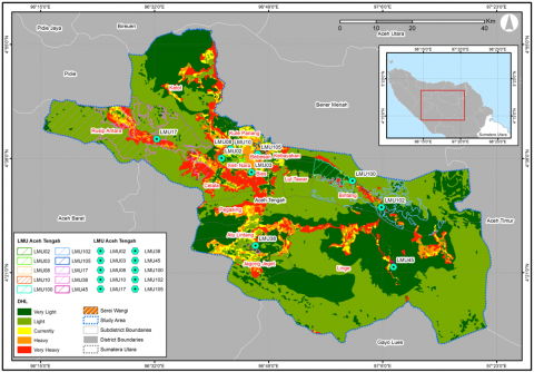
Figure 3. Erosion hazard levels on citronella land in the Central Aceh Regency
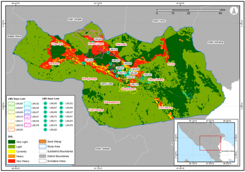
Figure 4. Erosion hazard levels on citronella land in Gayo Lues Regency
To sustain citronella cultivation in this fragile highland ecosystem, site-specific soil and water conservation measures are essential. Vegetative approaches such as cover cropping and agroforestry, combined with mechanical interventions like terracing and drainage canals, are critical for slope stabilization and erosion control [24]. Hazard maps (Figures 2-4) further illustrate spatial variability.
Spatial analysis of erosion hazard levels in citronella fields in the Gayo Highlands shows clear variations between regions.
In Bener Meriah Regency, moderate to severe erosion dominates the central and southwestern zones, which are characterized by undulating to steep terrain. In contrast, the northeastern areas remain relatively stable, with most LMUs classified as very light to light hazard levels.
In Central Aceh Regency, moderate to severe erosion is concentrated in the central and northwestern zones, overlapping with major citronella cultivation areas. The combination of steep slopes and high rainfall intensity contributes to elevated soil loss in these regions, while several LMUs in the eastern and southern zones exhibit lower erosion risks [25].
In Gayo Lues Regency, erosion hazards range from very light to very severe, reflecting the region’s steep volcanic slopes and heterogeneous land cover. LMUs located on slopes exceeding 40% recorded the highest erosion rates, whereas areas with gentler slopes and denser vegetation cover were classified in lower hazard categories [23].
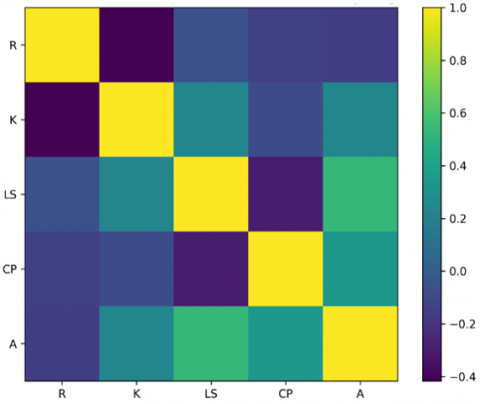
Based on the Pearson correlation matrix (Figure 5), the relationship between USLE factors and soil erosion (A) exhibited clear patterns. Slope length and steepness (LS) showed the strongest positive correlation, indicating that topography is the dominant factor controlling erosion variability in the Gayo Highlands. Land cover and conservation practices (CP) demonstrated a moderate positive correlation, confirming their significant role in reducing erosion, although less influential than slope conditions. Soil erodibility (K) also displayed a moderate positive correlation, suggesting its contribution to erosion rates, particularly through interactions with slope factors. In contrast, rainfall erosivity (R) showed a weak to negative correlation, indicating that rainfall intensity was not the primary driver of erosion differences among land units. Overall, the correlation matrix highlights LS as the most influential factor, followed by CP and K, while R exerted only a minor effect on erosion variability.
3.2 Layered protection strategy based on erosion risk and effect simulation
Soil conservation strategies for citronella cultivation in the Gayo Highlands are designed to mitigate the high erosion risk associated with steep topography and cultivation practices that are not fully adapted to local land conditions. In this study, simulations of selected conservation techniques were conducted using the P factor (conservation practices) component of the USLE model (Table 9).
Table 9. Soil conservation strategies and their effectiveness in reducing erosion
|
No. |
Conservation Strategy |
Erosion Pressure Prediction |
Description |
|
1 |
Without conservation (along the slope) |
0% |
Maximum erosion |
|
2 |
Planting along the slope |
20–50% |
Effective on moderate slopes |
|
3 |
Alley planting + pine |
40–60% |
Suitable for steep land |
|
4 |
Ridge/bench terraces |
50–90% |
Most effective but high cost |
Based on the evaluation and simulation results of soil conservation practices on citronella cultivation land in the Gayo Highlands, a multilevel conservation strategy was developed to align with varying land conditions and erosion risk levels. This strategy is structured progressively—from minimal to intensive interventions—with the overarching goal of reducing erosion rates, preserving soil fertility, and supporting sustainable agricultural productivity [26].
Summarizes soil conservation recommendations for lemongrass cultivation areas in the Gayo Highlands, categorized according to EHL (Table 10).
For areas classified as Very Low (EHC I)—including LMU20, LMU21, LMU23, LMU70, and LMU73 in Bener Meriah, and LMU02 and LMU45 in Central Aceh—basic vegetative techniques are recommended. These include contour planting, mulching, and the preservation of natural ground cover, which are effective in maintaining soil stability on gentle slopes [27, 28].
For areas with Low to Moderate erosion hazard levels (EHC II–III), such as LMU58 in Bener Meriah, LMU102 in Central Aceh, and LMU11 and LMU35 in Gayo Lues, conservation strategies emphasize the use of contour planting systems combined with alley cropping using perennial vegetation. This approach is particularly relevant for land with moderate slopes and has been shown to reduce soil loss by 40–60%, while enhancing soil structure and water infiltration capacity [29]. The strategic integration of planting orientation and vegetative barriers plays a critical role in suppressing surface runoff and maintaining slope stability. Moreover, this method remains accessible to local farmers, as it requires minimal investment and technical input [25, 27].
Table 10. Conservation recommendations based on EHL in citronella plantation areas at Gayo Highlands
|
No. |
Erosion Hazard Level (EHL) |
Erosion Hazard Class (EHC) |
LMU |
Recommended Conservation Strategies |
Predicted Erosion Pressure (%) and Technical Description |
|
1 |
Very Light |
I |
Bener Meriah: LMU 20, LMU 21, LMU 23, LMU 70, LMU 73; Central Aceh: LMU 02, LMU 45 |
Basic vegetative management (contour planting, mulching, natural ground cover |
10–20% — Suitable for flat to gently sloping land, sufficient with improvements in ground cover vegetation. |
|
2 |
Light |
II |
Bener Meriah: LMU 58; Central Aceh: LMU 38, LMU 102; Gayo Lues: LMU 10 |
Contour cropping system |
20–50% — Effective on moderate slopes (15–25%), easy for farmers to implement. |
|
3 |
Medium |
III |
Bener Meriah: LMU 61; Central Aceh: LMU 03, LMU10, LMU100; Gayo Lues: LMU11, LMU35, LMU78 |
An alley cropping system with perennial plants, such as pine or legumes |
40–60% — Suitable for hilly land (25–35%), enhances infiltration and soil moisture. |
|
4 |
Heavy |
IV |
Bener Meriah: LMU65, LMU71; Central Aceh: LMU105; Gayo Lues: LMU05, LMU07, LMU09, LMU19, LMU20, LMU37, LMU41 |
Ridge or simple bench terraces with stabilization vegetation (vetiver grass, legume ground cover) |
50–80% — Recommended for slopes > 35%, requires moderate investment. |
|
5 |
Very Severe |
V |
Bener Meriah: LMU60; Central Aceh: LMU08, LMU17; Gayo Lues: LMU32, LMU43 |
Permanent bench terraces, water drainage channels, and agroforestry-based reforestation |
70–90% — Suitable for very steep land (> 40%), requires high costs and expert labor. |
4.1 Estimation of soil erosion rates and spatial distribution of hazard levels
The rainfall erosivity factor (R) remained constant at 1,611.09 cm·yr⁻¹, indicating uniformly high rainfall intensity across the study region. Consequently, variations in erosion rates were more strongly influenced by slope length and steepness (LS), soil erodibility (K), and land cover/conservation practices (CP) than by rainfall alone. LS values ranged from 0.25 to 12, reflecting substantial differences in slope steepness among land units. Steeper slopes accelerated runoff and increased soil detachment [29]. Among the LMUs, LMU60 recorded the highest erosion rate (1,546.65 tons·ha⁻¹·yr⁻¹), driven by very steep slopes (LS = 12) and high C values (0.5), indicating limited vegetation cover and ineffective runoff control. In contrast, LMU20, LMU21, and LMU70 exhibited very low erosion rates (1.41–3.09 tons·ha⁻¹·yr⁻¹), attributed to extremely low CP values (0.001–0.05), reflecting dense vegetation cover and effective conservation practices [16]. Soil erodibility also played a critical role, with values ranging from 0.07 to 0.23. Higher K values corresponded to finer soil textures and lower aggregate stability, increasing susceptibility to soil particle detachment [30]. These findings highlight the need for soil and water conservation strategies tailored to local biophysical conditions, including terracing, agroforestry, cover cropping, and contour-aligned cultivation, which have proven effective in reducing runoff and enhancing soil retention in undulating to steep landscapes such as Bener Meriah.
Quantitative erosion hazard estimation for citronella plantations in the Aceh Highlands was conducted using the USLE, integrating R, K, LS, and CP factors. The high average annual rainfall—1,611.09 mm in Bener Meriah and Central Aceh, and 1,271.75 mm in Gayo Lues—indicates substantial erosive potential, particularly on steep terrain [31]. Spatial analysis of erosion hazard classes (EHC) revealed marked differences among regencies. In Central Aceh, erosion rates ranged from 0.06 to 1,056.07 tons·ha⁻¹·yr⁻¹, with LMU17 (Rusip Antara) and LMU08 (Silih Nara) classified as Very Severe (EHC V), while LMU45 and LMU02 were categorized as Very Light (EHC I), reflecting minimal erosion risk. These variations were primarily attributed to undulating to steep topography and land use practices lacking conservation measures [22].
Bener Meriah exhibited relatively more stable conditions, with most LMUs falling within Very Light to Moderate hazard categories, suggesting more moderate physiographic conditions and comparatively better land management. However, LMU60 and LMU65 remained vulnerable, particularly in areas with 25–40% slopes lacking sufficient vegetative protection [26]. In Gayo Lues, erosion hazard classes were predominantly Severe (EHC IV) to Very Severe (EHC V). LMU32 (Dadun Gelang) and LMU43 (Pantan Cuaca) recorded the highest erosion rates (1,220.88 and 732.53 tons·ha⁻¹·yr⁻¹), while LMU10 (Blangkejeren) was classified as Light (EHC II). The high erosion risk in this region was driven by steep slopes, fine-textured soils with high erodibility, and limited vegetation cover [32, 33].
The erosion hazard maps (Figures 2-4) illustrate spatial variability across the highlands. In Bener Meriah, moderate to severe erosion dominates central and southwestern zones, whereas northeastern areas remain relatively stable. In Central Aceh, moderate to severe erosion overlaps with major citronella cultivation areas in Pegasing, Ketol, Bebesen, and Atu Lintang, posing considerable risks of land degradation [31, 33]. In Gayo Lues, hazard levels range from Very Light to Very Severe, with critical zones concentrated in steep terrain. These spatial mismatches between cultivation areas and erosion-prone zones underscore the urgent need for soil and water conservation measures.
The LMU-based approach provides a strategic foundation for site-specific interventions, enabling precise targeting of erosion control practices such as cover vegetation planting, terracing, and contour cultivation, which have been shown to effectively reduce runoff and enhance slope stability [26]. The integration of spatial hazard mapping with conservation planning is therefore essential to balance agricultural development—particularly citronella cultivation—with environmental sustainability in the Aceh Highlands.
4.2 Layered protection strategy based on erosion risk and effect simulation
Simulations of selected conservation techniques were conducted using the P factor (conservation practices) component of the USLE model (Table 9). This modeling approach provides quantitative estimates of the effectiveness of conservation methods in reducing erosion rates, particularly on sloping land in humid tropical environments [22, 34].
The first strategy evaluated was contour cropping. Results showed that planting parallel to the slope without conservation measures produced erosion rates equivalent to 100% of the baseline, whereas planting along contour lines reduced erosion by 20–50%, depending on slope gradient. On slopes of 25–30%, contour cropping reduced surface runoff by up to 35%, confirming its effectiveness as a simple erosion control technique [35].
The second strategy was alley cropping, integrating citronella rows with strips of perennial vegetation such as pine or leguminous species. This system improved water infiltration, reduced erosion by 40–60% on slopes exceeding 30%, and enhanced soil moisture retention and structure, thereby supporting long-term agricultural productivity [36].
The third strategy was terracing. Bench terraces on slopes > 30% reduced erosion by 70–90%, while ridge terraces on moderate slopes (15–25%) reduced erosion by 50–70%. Despite their effectiveness, high construction and maintenance costs pose challenges, requiring adaptation to local socio-economic conditions [34].
Comparative analysis revealed that planting along slope gradients without conservation increased erosion rates by 1.5–2 times compared to contour-based planting. These findings highlight the critical role of cultivation practices in land degradation, particularly in topographically vulnerable areas. Integrated conservation strategies—combining vegetative approaches such as cover cropping and agroforestry with mechanical interventions like terracing—are therefore essential to sustain land productivity and prevent environmental degradation in the Aceh highlands [33].
At the minimal intervention level, farmers are encouraged to adopt contour planting, which reduces sheet and rill erosion, enhances soil moisture retention, and stabilizes citronella yields under sloping conditions [35]. At the moderate level, contour planting can be combined with alley cropping using woody species such as pine or legumes. This alley agroforestry system improves slope stability and water retention while providing additional outputs such as timber, fodder, and nitrogen fixation, thereby supporting ecological sustainability and income diversification [36]. Adopting soil conservation strategies tailored to erosion hazard levels is critical for maintaining the productivity and ecological sustainability of citronella cultivation in the Gayo Highlands.
For slopes exceeding 25%, a maximum conservation strategy is required, primarily through terracing, which regulates surface water flow, minimizes runoff, and reduces soil displacement; although costly in terms of labor and technical expertise, terraces provide long-term benefits such as sustained productivity, reduced topsoil loss, improved water availability, and lower landslide risk [34].
In areas with Low to Moderate erosion hazard levels (EHC II–III), such as LMU58 in Bener Meriah, LMU102 in Central Aceh, and LMU11 and LMU35 in Gayo Lues, conservation strategies focus on contour planting combined with alley cropping, which can reduce soil loss by 40–60%, enhance soil structure, and improve infiltration capacity, while remaining accessible to farmers due to relatively low investment requirements. Meanwhile, for Severe to Very Severe hazard levels (EHC IV–V)—including LMU65 and LMU71 in Bener Meriah, LMU105 in Central Aceh, and LMU32 and LMU43 in Gayo Lues—mechanical conservation techniques are indispensable, with recommended interventions such as contour and bench terraces to effectively mitigate erosion risks.
The Pearson correlation matrix analysis revealed that slope length and steepness (LS) are the most dominant factors influencing soil erosion in the Gayo Highlands, followed by land cover and conservation practices (CP) and soil erodibility (K), while rainfall erosivity (R) showed minimal impact. These findings emphasize that topographic conditions and vegetation management are the primary determinants of erosion variability, indicating that conservation strategies should prioritize slope control and the enhancement of vegetation cover.
Nevertheless, the implementation of conservation strategies in the field faces several socio-economic challenges. High initial costs for constructing permanent terraces, drainage channels, and agroforestry systems remain a major barrier for smallholder farmers, necessitating financial support through subsidies, cover crop seedlings, or access to microcredit schemes. From a labor perspective, terrace construction and vegetation maintenance increase workloads, making organized labor-sharing approaches through farmer groups a more practical solution. Limited technical knowledge also constrains the design of contour-aligned terraces, the spacing of infiltration pits, and the selection of cover crops, highlighting the need for technical training, visual guidelines, and demonstration plots to ensure effective implementation.
Market-based incentives further strengthen adoption, as income diversification through agroforestry and eco-certification can enhance the market value of products such as citronella oil, thereby linking conservation practices to economic benefits. The effectiveness of soil conservation in the Gayo Highlands relies not only on the application of appropriate vegetative and mechanical techniques but also on overcoming socio-economic barriers through financial support, technical training, market incentives, and strong local governance, ensuring both ecological sustainability and the long-term viability of citronella-based farming systems [37, 38].
This study demonstrates that soil erosion in the Aceh Highlands is governed primarily by slope steepness, soil erodibility, vegetation cover, and conservation practices, rather than rainfall intensity alone. Quantitative estimation using the USLE revealed substantial spatial variability in erosion hazard levels, with Central Aceh and Gayo Lues containing several land units classified as Severe to Very Severe, while Bener Meriah exhibited relatively more stable conditions. The highest erosion rates were consistently associated with steep slopes, fine-textured soils, and inadequate vegetative protection, underscoring the dominant role of landform and management practices in controlling erosion.
Simulations of layered conservation strategies confirm that contour planting can reduce erosion by 20–50%, alley cropping by 40–60%, and terracing by up to 90%. Minimal interventions such as contour planting are effective under moderate conditions, while alley agroforestry systems provide both ecological and economic benefits. In severe hazard zones, mechanical measures such as bench and contour terraces are indispensable despite their higher costs.
The LMU-based spatial analysis provides a strategic framework for site-specific interventions, enabling precise targeting of conservation practices. However, successful implementation requires overcoming socio-economic barriers, including high investment costs, labor demands, and limited technical capacity. Financial support, farmer training, organized labor-sharing, and market-based incentives such as eco-certification are critical to ensure adoption.
Integrating hazard mapping with adaptive conservation planning, supported by local governance and community participation, is therefore essential to sustain citronella cultivation, safeguard agricultural productivity, and preserve the ecological integrity of tropical highland ecosystems.
The authors gratefully acknowledge the support of the Aceh Government and Universitas Syiah Kuala in facilitating this research. Special appreciation is extended to the Head of the Doctoral Program in Agricultural Sciences, Universitas Syiah Kuala, for the continuous support and encouragement that ensured the smooth progress of this study. Further gratitude is expressed to all contributors, reviewers, and field participants whose insights and assistance enriched the quality and relevance of this work.
[1] FAO. (2019). Outcome Document of the Global Symposium on Soil Erosion. Rome. http://www.fao.org/3/ca5697en/ca5697en.pdf.
[2] Sitorus, T.A., Sumarniasih, M.S., Trigunasih, N.M. (2023). Analysis of erosion levels and conservation planning based on geographic information systems in Rendang District, Karangasem Regency, Bali Province. Agrotrop: Journal on Agriculture Science, 13(2): 256. https://doi.org/10.24843/ajoas.2023.v13.i02.p09
[3] Mandal, D., Patra, S., Sharma, N.K., Alam, N.M., Jana, C., Lal, R. (2023). Impacts of soil erosion on soil quality and agricultural sustainability in the North-Western Himalayan Region of India. Sustainability (Switzerland), 15(6): 5430. https://doi.org/10.3390/su15065430
[4] Karim, A., Sugianto, S., Fazlina, Y.D., Rusdi, M., Manfarizah, M., Hifnalisa, H. (2020). Land arrangement for citronella (Cymbopogon nardus) and arabica coffee in the cultivation area in Gayo Lues District, Aceh Province Indonesia: A land suitability approach. Aceh International Journal of Science and Technology, 9(3): 207-215. https://doi.org/10.13170/aijst.9.3.18495
[5] Ramli, I., Achmad, A., Basri, H., Izzaty, A. (2022). Erosion and distribution of total suspended sediment (TSS) using Landsat-8 in Krueng Pase watershed. In Proceedings of the Second International Conference of Construction, Infrastructure, and Materials: ICCIM 2021, 26 July 2021, Jakarta, Indonesia, pp. 23-33. https://doi.org/10.1007/978-981-16-7949-0_3
[6] Kaur, H., Bhardwaj, U., Kaur, R. (2021). Cymbopogon nardus essential oil: A comprehensive review on its chemistry and bioactivity. Journal of Essential Oil Research, 33(3): 205-220. https://doi.org/10.1080/10412905.2021.1871976
[7] Directorate General of Plantations, Ministry of Agriculture of the Republic of Indonesia. (2024). Publication of Plantation Statistics Book. https://ditjenbun.pertanian.go.id/pojok-media/publikasi/?utm_source=copilot.com.
[8] Basri, H., Syakur, S., Azmeri, A., Fatimah, E. (2022). Floods and their problems: Land uses and soil types perspectives. IOP Conference Series: Earth and Environmental Science, 951(1): 012111. https://doi.org/10.1088/1755-1315/951/1/012111
[9] Hutasuhut, M.I.A., Moulana, R., Martunis, M. (2020). Growth rate of lemongrass plantations in Gayo Lues Regency. Jurnal Ilmiah Mahasiswa Pertanian, 6(2): 178-182.
[10] Bahar, A., Indrayatie, E.R., Pujawati, E.D. (2020). The role of serai wangi (Cymbopogon nardus) in the soil physical and chemical properties. Jurnal Sylva Scienteae, 3(1): 36-50.
[11] Benavidez, R., Jackson, B., Maxwell, D., Norton, K. (2018). A review of the (Revised) Universal Soil Loss Equation ((R)USLE): With a view to increasing its global applicability and improving soil loss estimates. Hydrology and Earth System Sciences, 22(11): 6059-6086. https://doi.org/10.5194/hess-22-6059-2018
[12] Pham, T.G., Degener, J., Kappas, M. (2018). Integrated universal soil loss equation (USLE) and geographical information system (GIS) for soil erosion estimation in A Sap basin: Central Vietnam. International Soil and Water Conservation Research, 6(2): 99-110. https://doi.org/10.1016/j.iswcr.2018.01.001
[13] Devianti, D., Ramli, I., Aryani, I., Satrio, P., Thamren, D.S. (2023). Estimation of erosion and sediment using Gavrilović method in Krueng Jreu Sub-Basin, Aceh Province, Indonesia. Journal of Tekirdag Agricultural Faculty, 20(2): 430-440. https://doi.org/10.33462/jotaf.1183026
[14] Yuliana, Y., Aji, I.M. L., Sari, D.P. (2025). Erosion prediction using the universal soil loss equation (USLE) Method in the Kerandangan Watershed, West Lombok Regency. ULIN: Jurnal Hutan Tropis, 9(1): 60-73. https://doi.org/10.32522/ujht.v9i1.14979
[15] Azmeri, A., Nurbaiti, N., Mawaddah, N., Yunita, H., Jemi, F.Z., Sundary, D. (2022). Surface erosion hazard and sediment yield for Keuliling Reservoir in Indonesia. Journal of Water and Land Development, 52: 108-118. https://doi.org/10.24425/jwld.2022.140380
[16] Iashania, Y., Syafi'i, A.A. (2025). Soil erosion analysis in reclamation and land clearing areas using the USLE and RUSLE approaches. Buletin Profesi Insinyur, 8(1): 8-14. https://doi.org/10.20527/bpi.v8i1.287
[17] Susilowati, M., Syukur, C. (2022). Characterization of several accessions of Lemongrass (Cymbopogon nardus L.) from Cianjur. Vegetalika, 11(4): 305-314. https://doi.org/10.22146/veg.77033
[18] Hombegowda, H.C., Adhikary, P.P., Madhu, M., Jakhar, P., Vanitha, S.M., Raza, M.B. (2025). Assessment of production and soil conservation potential of aromatic grasses grown under shifting cultivated degraded hill slopes of Eastern Ghats, India. Agricultural Research, 14(1): 109-120. https://doi.org/10.1007/s40003-024-00761-3
[19] Wischmeier, W.H., Smith, D.D. (1978). Predicting rainfall erosion losses: A guide to conservation planning (No. 537). Department of Agriculture, Science and Education Administration.
[20] Wischmeier, W.H., Johnson, C.B., Cross, B.V. (1971). A soil erodibility nomograph for farmland and construction sites. Journal of Soil and Water Conservation, 26(5): 189-193. https://doi.org/10.5555/19721902373
[21] Hammer, W.I. (1982). Final soil conservation report. Center for Soil Research. Bogor.
[22] Panagos, P., Borrelli, P., Meusburger, K., Alewell, C., Lugato, E., Montanarella, L. (2015). Estimating the soil erosion cover-management factor at the European scale. Land Use Policy, 48: 38-50. https://doi.org/10.1016/j.landusepol.2015.05.021
[23] Ascencio-Sanchez, M., Padilla-Castro, C., Riveros-Lizana, C., Hermoza-Espezúa, R.M., Atalluz-Ganoza, D., Solórzano-Acosta, R. (2025). Impacts of land use on soil erosion: RUSLE analysis in a sub-basin of the Peruvian Amazon (2016-2022). Geosciences, 15(1): 15. https://doi.org/10.3390/geosciences15010015
[24] Shinde, V., Singh, M., Nandgude, S., Bharti, B. (2020). Modelling the effect of conservation measures on potential soil erosion. Current Science, 119(6): 984-991. https://doi.org/10.1007/s10661-023-11234-9
[25] USDA NRCS. (2001). Revised Universal Soil Loss Equation Version 2 (RUSLE2). United States Department of Agriculture, Washington, D.C. https://www.nrcs.usda.gov/sites/default/files/2022-10/RUSLE2%20Handbook_0.pdf.
[26] Napitupulu, R.E., Andawayanti, U., Lufira, R.D., Pratama, R.R. (2024). Erosion rate analysis and land conservation direction based on geographic information system in Way Rarem Subwatershed, Lampung Province. Civil and Environmental Science Journal, 7(2): 115-130. https://doi.org/10.21776/ub.civense.2024.007.02.10
[27] Pratama, M.R.Y. (2025). Erosion prediction using USLE and RUSLE methods in Bawang Gajah sub-watershed, Central Aceh District. Universitas Malikussaleh. https://rama.unimal.ac.id/id/eprint/15135.
[28] Rizkiani, A.B., Wilis, R. (2025). Analysis of the level erosion hazard on land use change in the Tenggulun Hulu Sub-Watershed, Aceh Tamiang District. GeoEco, 11(2): 374-393. https://doi.org/10.20961/ge.v11i2.98666
[29] Saidah, S., Ruslan, M., Hafizianor, H. (2025). Analysis of erosion hazard levels using USLE method in the Bati-Bati Sub-Watershed, Indonesia. International Journal of Research and Review, 12(7): 234-243. https://doi.org/10.52403/ijrr.20250744
[30] Muhana, N.H.N., Al Ghifari, M.S., Putri, A.N., Syaharani, A.P., Saputri, M.M.A., Sutan Haji, A.T. (2024). Mapping of erosion hazard levels and mitigation recommendations in the UB Forest Area, Tawangargo Village, Malang Regency. Jurnal Sumberdaya Alam dan Lingkungan, 11(1): 42-53. https://doi.org/10.21776/ub.jsal.2024.011.01.5
[31] Andriyani, I., Indarto, I., Soekarno, S., Pradana, M.P. (2024). Analysis of rainfall erosivity factor (R) on prediction of erosion yield using USLE and RUSLE models: A case study in Mayang Watershed, Jember Regency, Indonesia. Sains Tanah-Journal of Soil Science and Agroclimatology, 21(1): 64-73. https://doi.org/10.20961/stjssa.v21i1.63641
[32] Huang, X., Lin, L., Ding, S., Tian, Z., Zhu, X., Wu, K., Zhao, Y. (2022). Characteristics of soil erodibility k value and its influencing factors in the Changyan Watershed, Southwest Hubei, China. Land, 11(1): 134. https://doi.org/10.3390/land11010134
[33] Kogo, B.K., Kumar, L., Koech, R. (2020). Impact of land use/cover changes on soil erosion in Western Kenya. Sustainability, 12(22): 9740. https://doi.org/10.3390/su12229740
[34] Choudhary, R., Sharma, S., Gautam, S.K. (2024). Contour farming and strip cropping for soil protection. In Soil Conservation Techniques and Erosion Control, pp. 112-130. https://doi.org/10.61887/glp.2024.24
[35] Fajeriana, N., Ali, A., Rini, R.P. (2024). Soil tillage and planting along the contour on sloping land to minimize the potential for erosion and surface runoff. Sarhad Journal of Agriculture, 40(1): 82-93.
[36] Neswati, R., Abdullah, S., Musa, Y., Nasaruddin. (2023). Assessing soil conservation techniques on sloping lands in the humid tropics area of Indonesia in the context of maize cultivation. Biodiversitas Journal of Biological Diversity, 24(3).
[37] Dharmawan, I.W.S., Pratiwi, Siregar, C.A., Narendra, B.H., Undaharta, N.K.E., Sitepu, B.S., Sukmana, A., Wiratmoko, M.D.E., Abywijaya, I.K., Sari, N. (2023). Implementation of soil and water conservation in Indonesia and its impacts on biodiversity, hydrology, soil erosion, and microclimate. Applied Sciences, 13(13): 7648. https://doi.org/10.3390/app13137648
[38] Safri, F.M., Humam, H.A. (2019). Citronella agroforestry in Gayo Lues regency of Indonesia. Russian Journal of Agricultural and Socio-Economic Sciences, 87(3): 290-297. https://doi.org/10.18551/rjoas.2019-03.34