Ernawati*![]() | Risky Ramadhan
| Risky Ramadhan![]() | Mohd Hairy Bin Ibrahim
| Mohd Hairy Bin Ibrahim![]() | Arie Yulfa
| Arie Yulfa![]() | Tengku Adeline Adura Binti Tengku Hamzah
| Tengku Adeline Adura Binti Tengku Hamzah![]() | Azhari Syarief
| Azhari Syarief![]()
© 2025 The authors. This article is published by IIETA and is licensed under the CC BY 4.0 license (http://creativecommons.org/licenses/by/4.0/).
OPEN ACCESS
This research examines the integration of disaster mitigation into spatial planning in Indonesia, specifically focusing on the earthquake vulnerability of Kajai in Pasaman Barat Regency. The study aims to refine spatial planning strategies to enhance resilience and inform government policies, ultimately reducing disaster impacts and promoting sustainable recovery in high-risk areas. In Kajai, both primary data from field observations and secondary data from regional spatial plans were employed. The Ground Motion Prediction Equations (GMPE) method was utilized alongside GIS for spatial analysis, assessing earthquake hazards to improve disaster resilience. GMPE was selected due to the presence of the active Semangko fault and complex local geological conditions, which significantly affect ground motion in the area. The earthquake hazard map categorizes areas into five vulnerability typologies, with area distribution as follows: Stable zone (8,636.78 ha), Typology A (1,761.89 ha), Typology B (702.11 ha), Typology C (71.46 ha), and Typology D (16.42 ha). The most vulnerable zone, Typology D, is concentrated in the hamlets Lubuak Sariak and Tanjung Beruang. Despite being designated as an agricultural zone in the spatial development plan, Kajai lacks protected zones for earthquake-hazard areas, underscoring the need for integrating seismic risk into spatial planning to ensure community safety.
earthquake-hazard, GMPE, Kajai Village, mitigation, spatial pattern
In disaster-hazard countries like Indonesia, spatial planning is inherently a crucial disaster mitigation strategy aimed at reducing disaster risk through land-use regulations. Identifying zones susceptible to seismic shaking ensures that high-risk developments are avoided. In addition to risk reduction, spatial planning facilitates recovery, protects the environment, promotes sustainable living, and supports evacuation efforts [1].
Indonesia, situated between multiple tectonic plates, is highly prone to earthquakes and volcanic eruptions [2, 3]. For prediction and for reducing vulnerability against future earthquake disasters, it is important to understand the factors that cause geographic patterns [4]. The National Board for Disaster Management (BNPB) recorded 2,168 disasters from January to August 2022, reflecting an increase of 1,805 disasters in the same period of 2021. Among these were landslides, earthquakes [5], forest fires, floods, tidal waves, and abrasion [6].
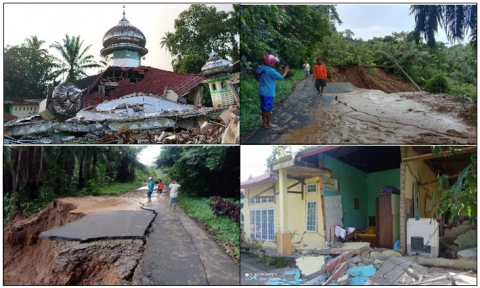
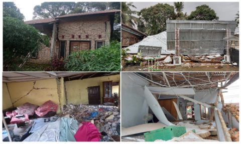
West Sumatra, a province highly susceptible to seismic hazards, is traversed by the Semangko Fault—part of the Great Sumatra Fault Zone—recognized as one of the most active strike-slip fault systems in the world [7, 8]. This fault zone runs parallel to the Sunda Trench and plays a critical role in accommodating oblique convergence between the Indo-Australian and Eurasian plates [9]. A significant seismic event occurred on March 8, 1977, known as the Pasaman earthquake, which registered a magnitude of 6.1, with its epicenter at 0.5°N and 100.04°E, and a depth of 19.5 kilometers. In Sinurat Sub-district, the quake severely damaged 737 houses, a market, seven schools, eight mosques, and three government buildings, while in Talu Sub-district, 245 houses, three schools, and eight mosques were similarly affected [10]. Decades later, on January 25, 2022, another powerful earthquake with a magnitude of 6.2 struck Pasaman Barat Regency, also situated along this fault system. The event resulted in widespread destruction—damaging infrastructure, collapsing roads, and disrupting essential public services. The extent of the impact highlights the pressing need to reassess regional spatial planning strategies to strengthen disaster resilience. The following images illustrate the damage in Kajai, Pasaman Barat, caused by the 2022 earthquake (Figure 1).
To address these recurring disasters, integrating disaster mitigation into spatial planning is essential. Land-use control is one of the fundamental mechanisms in reducing disaster risk by restricting development in high-risk zones, as mandated in the Minister of Public Works Regulation No. 22 of 2007 [11]. Research has shown that effective zoning policies significantly reduce disaster-related damages. Additionally, implementing and enforcing building codes that require earthquake-resistant design, such as the Indonesian National Standard [12], is crucial in minimizing structural failures. Studies indicate that adherence to seismic design standards can reduce earthquake-induced fatalities by up to 60 percent.
Figure 1. Photos of the damage caused by the earthquake in Kajai
Currently, the earthquake hazard map for West Sumatra is on a small scale (1:650,000), limiting its effectiveness. This map categorizes areas into five vulnerability zones comprising approximately 30 percent of the total area, including Kajai Village, where significant damage occurred. The Regulation of the Minister of Public Works No. 21 of 2007 emphasizes the need for a more detailed, large-scale earthquake hazard map [11]. Such maps are critical for precise evaluations, particularly in severely affected areas like Kajai.
Ground Motion Prediction Equations (GMPE) is applicable to different types of seismic areas as they account for local geological conditions and fault characteristics influencing earthquake intensity. In Pasaman Barat, GMPE is particularly relevant due to the presence of the Semangko fault and multiple active seismic sources. The application of GMPE allows for more accurate estimations of seismic hazards, aiding in the development of resilient spatial planning strategies [13]. However, other methods, such as Probabilistic Seismic Hazard Analysis (PSHA) and Deterministic Seismic Hazard Analysis (DSHA), are also widely used in seismic hazard mapping. PSHA considers uncertainties in earthquake occurrence and ground motion, providing probabilistic estimates of seismic risk over a given time period [14]. Meanwhile, DSHA focuses on worst-case earthquake scenarios by analyzing the largest possible earthquakes that could affect a region. Comparing these methods, GMPE is beneficial for rapid hazard estimation and practical applications in urban planning, while PSHA offers a comprehensive risk assessment framework for long-term disaster preparedness [9, 15].
This study aims to evaluate the spatial patterns in Nagari Kajai concerning the earthquake vulnerability map. The findings are expected to inform government policies, enabling more effective refinement of current spatial planning strategies in high-risk areas. Ultimately, through land-use regulations, building code enforcement, the resilience of disaster-hazard regions, mitigating long-term impacts, and ensuring sustainable recovery.
2.1 Study area
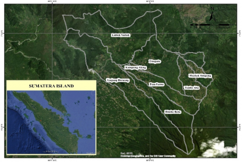
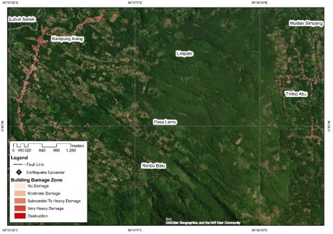
The research was carried out in Kajai Village, Talamau District, Pasaman Barat Regency. The word Kajai is the name of the traditional local village, which has a total area of 11,184.45 hectares and is bordered by several other villages, namely, to the north is Talu village, south is Aua Kuning village, west is Lingkuang Aua village, and to the east is Bangun Purba village.
Figure 2. Research location map
This village consists of eight hamlets, namely Tanjung Beruang, Rimbo Batu, Kampung Alang, Limpato, Mudiak Simpang, Timbo Abu, Lubuak Sariak, and Pasa Lamo. The geography and local culture of Kajai itself have a diverse landscape and community structure, which makes it a significant part of the Talamau Mountains (Figure 2).
2.2 Research instruments
This study integrated both primary (field observations) and secondary data (spatial planning documents) for comprehensive analysis. The primary data were obtained through documentation, observations, and visits to the field after the earthquake in Nagari Kajai (Table 1). The collection of building damage coordinate data after an earthquake is crucial for assessing structural impacts and planning recovery efforts, while 2D geoelectrical surveys provide subsurface resistivity profiles to analyze soil stability and detect potential hazards such as liquefaction-prone areas [16]. To ensure the accuracy and reliability of the collected data, a rigorous quality control process should be implemented, including cross-validation with satellite imagery [17], GPS accuracy checks, and standardized field data collection protocols [18]. Similarly, 2D geoelectrical surveys must undergo thorough data filtering, inversion analysis, and calibration against borehole data to minimize errors and improve interpretation accuracy [10]. Combining these methods with strict quality control enables a comprehensive evaluation of both surface and subsurface conditions, supporting effective disaster mitigation and urban planning [19].
The collection of secondary data in the form of spatial planning documents involves obtaining official records from government agencies, such as regional planning departments, land use authorities, and disaster management offices [20]. This process includes verifying document authenticity, ensuring data completeness, and standardizing formats for compatibility with GIS applications [21]. To ensure quality control in spatial planning data for Pasaman Barat Regency, cross-validation with satellite imagery and field surveys should be conducted, alongside consistency checks with national and regional regulations [17, 22]. Implementing these quality control measures enhances data reliability and supports effective land use planning and disaster risk mitigation [23, 24].
2.3 Data analysis
In this study, spatial analysis was conducted using a geospatial approach through a Geospatial Information System (GIS), specifically employing the overlay intersect method to integrate multiple spatial parameters. This method allows for precise spatial data intersection by combining geology, slope, seismicity and geological structure layers to generate a comprehensive hazard assessment map. The analysis was performed using a weighted overlay approach, where each parameter was assigned a weight based on its relative influence, following a structured ability assessment framework [17, 25, 26]. This approach ensures a systematic evaluation of spatial relationships, enhancing the accuracy of hazard and risk assessments in the study area [27].
Table 1. Matrix of types, data sources and research outputs
|
Data |
Data Type |
Source |
Output |
|
Primary |
Building damage coordinates |
Observation |
Building damage zoning |
|
Geological conditions of earthquakes |
Observation |
Field conditions include morphology and faults |
|
|
Digital Elevation Model |
Inageoportal |
Slope Map |
|
|
Seismicity |
Observation 2D Geoelectric Crosssection profile |
Peak ground acceleration |
|
|
Secondary |
Regional Spatial Pattern Plans Pasaman Barat Regency for 2011-2030 |
Regional Development Planning Agency of Pasaman Barat Regency |
Spatial Map of Kajai Village |
|
Administrative Map of Kajai Village |
Inageoportal (BIG) Website |
Administrative Border Map of Kajai Village |
Table 2. Parameters for earthquake hazard using GPME
|
No. |
Parameter |
Information |
Ability Assessment |
Weight |
Score |
||
|
1 |
Geology (Physical Properties and Engineering of Rocks) |
Andesit, granite, dioritis, metamorph, brax volcanic, agglomerate, braksi sedimen, conglomerate |
1 |
3 |
3 |
||
|
Sandstone, rough tufa, siltstone, arkose, greywacke, limestone |
2 |
6 |
|||||
|
Sand, silt, mudstone, napalm, fine tufa, shale |
3 |
9 |
|||||
|
Clay, sludge, organic clay, peat |
4 |
12 |
|||||
|
2 |
Slope |
Flat - Ramp (0-7%) |
1 |
3 |
3 |
||
|
Slooping - Steep (7-30%) |
2 |
6 |
|||||
|
Steep - Very steep (30-140%) |
3 |
9 |
|||||
|
Rugged (>140%) |
4 |
12 |
|||||
|
3 |
Seismicity |
MMI |
α |
Richter |
|
5 |
|
|
I,II,III,IV,V |
> 0.05 g |
< 5 |
1 |
5 |
|||
|
VI,VII |
0.05 – 0.15 g |
5 – 6 |
2 |
10 |
|||
|
VIII |
0.15 – 0.30 g |
6 – 6.5 |
3 |
15 |
|||
|
IX,X,XI,XII |
> 0.30 g |
> 6.5 |
4 |
20 |
|||
|
4 |
Geological Structure |
Away from fault zones |
1 |
4 |
4 |
||
|
Close to fault zones ( 100 – 1000 m dari zona sesar) |
2 |
8 |
|||||
|
In the fault zone (< 100 m of fault zones ) |
4 |
16 |
|||||
2.3.1 Earthquakes hazard based on Ground Motion Prediction Equations (GMPE)
The investigation of earthquake hazard in Kajai Village was conducted using the method known as Ground Motion Prediction Equations (GMPE). The following are the GMPE parameters used in this study (Table 2).
The peak ground acceleration (PGA) score of a given location is determined through a conversion calculation of earthquake parameters that are acquired using an accelerograph instrument [13, 14, 28, 29]. Here is the formula used:
$\log 10(A)=c 1+c 2 M+c 3 \log 10(R)+c 4 R+c 5 Z+\epsilon$. (1)
where,
|
A |
Ground motion parameter measured, such as peak ground acceleration (PGA), spectral acceleration (SA), or other ground motion parameters. |
|
M |
Earthquake magnitude (usually for moment magnitude). |
|
R |
Distance between the measurement location and the earthquake source (can be the epicentral distance or distance to the surface projection of the source). |
|
Z |
An additional parameter related to geological conditions or the depth of the earthquake |
|
C1-C5 |
Coefficients determined through empirical data analysis, which may vary depending on the type of earthquake or region. |
|
ϵ |
The random error component that captures variability not explained by the model |
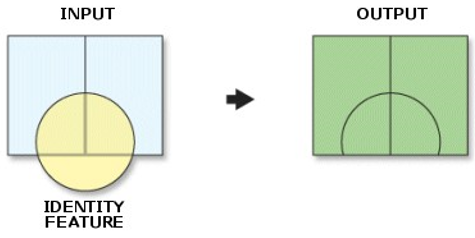
As a modification of GMPE, Formula (1) performs a parameter conversion calculation to produce the PGA value of earthquake disaster vulnerability [28]. The intersect overlay method is employed for spatial analysis (Figure 3).
Overlay is a map overlapping technique that generates new spatial data from multiple spatial data inputs. The overlay results are classified into five categories with rankings and weights according to Table 2, producing scores to determine the earthquake vulnerability classes in Kajai [3, 4, 6, 30]. Earthquake vulnerability areas are classified based on risk levels, considering geological data and stability assessments. These areas are categorized into five types:
Type Stable – Located far from fault zones with strong rock formations that absorb seismic energy, reducing damage even during strong earthquakes (MMI VIII) [8, 31].
Type A – Vulnerability arises from multiple factors, such as high-intensity earthquakes (MMI VIII) and medium-strength rock formations, leading to significant damage, especially to simple structures [2, 28].
Type B – High vulnerability due to weak rock formations combined with high-intensity earthquakes or proximity to a fault zone, causing severe damage, especially to concrete buildings [14, 32, 33].
Type C – Extremely vulnerable due to multiple weakening factors, such as steep slopes, weak rock, and exposure to tsunamis, leading to widespread destruction [17].
Type D – Located near fault lines and epicentres, with high-intensity earthquakes and tsunami risk [6]. Weak rock formations and steep slopes further increase damage potential [24]. The most hazardous area, exposed to strong earthquakes, destructive fault zones, and severe tsunamis. Soft rock formations and steep terrain make it highly unstable, leading to catastrophic damage [7]. This classification aids in risk assessment and disaster mitigation planning.
2.3.2 Evaluation of spatial pattern plans using earthquake hazard
After knowing about the types of earthquake disaster-hazard typology areas, the next step is to determine the spatial pattern in the earthquake area based on the regulation of the Minister of Public Works 22 Year 2007 [11]. Below explains the use of spatial in earthquake-hazard areas (Table 3).
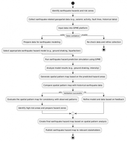
The process of creating an earthquake hazard map involves identifying risk zones, collecting and validating earthquake-related geospatial data, selecting an appropriate model, running simulations, analyzing results, and creating a spatial pattern map. The map is validated with historical data, evaluated for consistency, and then published to relevant stakeholders. The research flow chart is shown in Figure 4.
Figure 3. Intersect overlay process
Table 3. Spatial planning instructions based on earthquake typology
|
Typologies A |
|
|
Determination of spatial patterns and spatial structures |
|
|
Typologies B |
|
|
Determination of spatial patterns and spatial structures |
|
|
Typologies C |
|
|
Determination of spatial patterns and spatial structures |
|
|
Typologies D |
|
|
Determination of spatial patterns and spatial structures |
|
Figure 4. Research flow chart
3.1 Earthquakes hazard in Kajai Village, Pasaman Barat Regency
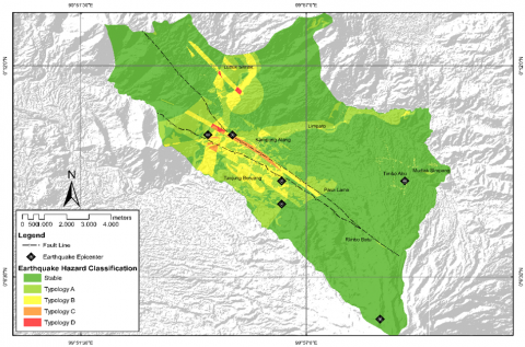
A disaster-hazard area is characterized by geological, topographical, geographical, and technological conditions that, over a specific period, limit its capacity to prevent, mitigate, or prepare for hazards, thereby reducing its ability to respond effectively to potential disasters [34-36]. The geological map below illustrates key vulnerability factors in Kajai Nagari, including slope stability, fault lines, and seismic activity, which are critical in assessing earthquake risk and guiding disaster mitigation strategies [30].
The earthquake hazard in West Sumatra, particularly in Pasaman Barat, is significantly high due to the active Sumatran Fault system, which passes through regions like Kajai. This dextral strike-slip fault, spanning approximately 1,900 km along the Bukit Barisan Mountains, is formed by the oblique convergence of the Indo-Australian and Eurasian plates, generating substantial tectonic stress [5, 27, 37]. Comprising 20 major segments, the fault extends from Lampung to Banda Aceh, with its northern continuation reaching the Andaman Sea and Burma [38]. The fault system not only triggers frequent seismic activity but also contributes to geomorphological changes, evident in the formation of hills, lakes, and landslide-hazard zones [39]. Given its high seismicity, the region remains vulnerable to major earthquakes and associated hazards, emphasizing the need for continuous monitoring and disaster mitigation efforts [7, 8, 10]. More details are shown in Figure 5.
The geological analysis reveals that Kajai Village is predominantly dominated by pyroclastic materials, covering 35.05% of the total area, while deposits of chunks, crags, pebbles, sand, and clay account for only 0.53%. This composition suggests a high susceptibility to geohazards, particularly landslides and seismic amplification, due to the unconsolidated nature of pyroclastic deposits [40]. Geographically, Kajai is situated at an elevation of approximately 450 meters above sea level with significant topographical variation influenced by its position between Mount Talamau and surrounding crater-like hills. The area's slope ranges from flat (0-7%) to slightly steep (7-30%), steep (30-140%), and very steep (>140%), which further contributes to its geomorphological instability and potential for mass movement events [41].
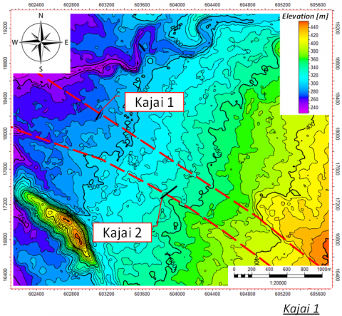
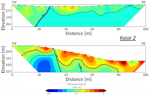
Figure 5. The straightness of the two active faults of the Kajai fault, forming a NW-SE trending graben, which can be seen from the results of the 2D geophysical survey interpretation
Identifying and mapping geological features, such as faults and volcanic deposits, is crucial for understanding the Earth's dynamic processes and assessing natural hazards like earthquakes and volcanic activity near Kajai area. By analyzing surface conditions and subsurface structures, this research can pinpoint fault lines and volcanic layers, which are essential for predicting and mitigating the impacts of these potential hazards. Additionally, understanding geomorphological changes, such as shifts in river courses or the formation of new landforms, provides insights into the long-term effects of geological activity on the landscape. The Kajai area's geological conditions are often defined by morphology related to unstable quaternary volcanic deposits, which are followed by active fault systems. Because of this, the Kajai region and the surrounding area are vulnerable to shallow earthquakes as well as related catastrophes like landslides and debris flows. Regarding the texture and genetic makeup of the landscape, the Kajai region includes the Ancient Crater Plain of Talu, Upper Volcano Slopes, Middle Volcano Slopes, Lower Volcano Slopes, Denuded Volcano Hill, Denudacial Hill, Isolated Hill, and Barely Lifted Plain. These features exhibit metamorphic and metasedimentary rock units of Carboniferous age, as well as volcanic sedimentary rocks (Volcaniclastic and Pyroclastics) of Tertiary to Quartery period. The morphology of Talamau Mountain's lower volcanic slope was the subject of two geoelectric surveys on the valley lineament. The results revealed the shades of two typical faults with dip azimuths facing one another. By forming a NW-SE trending valley morphology that diverts the B. Talu River's direction and becomes a place of deposition of the youngest volcanic Talamau deposits (Upper part of reddish line), which consist of volcanic breccia with a resistivity value of 320 Ωm to 10,000 Ωm, these two indications show the beginning of the development of a younger graben morphology than the age of the volcanic Talamau, which is interpreted as being nearly the same direction as the active fault. Figure 5 shows the results of measurements using geoelectricity on the kajai fault.
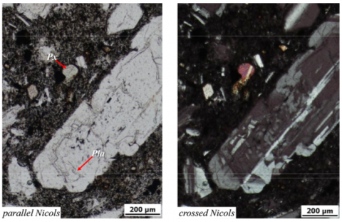
In general, the rocks in the Talamau area are composed of various rock formations, including sedimentary, volcanic, and intrusive rocks. As the lava flows crossed by a fault, layers of volcanic breccia, coarse to fine tuff, and volcanic deposits from Talamau mountain. Figure 6 is an example of a rock sample in Nagari Kajai from a field survey.
Figure 6. Parallel and crossed Nicols on thin section samples of a fresh matrix from Volcanic Breccia showing the product of magmatic corrosion (resorption, dissolution)
Figure 7. Earthquakes hazard in Kajai Village
The surface observations revealed fresh volcanic deposits with coarse sand to gravel grain sizes. On a microscopic scale, plagioclase phenocrysts with polysynthetic twinning, compositional zoning, and a little alteration to secondary feldspar are seen in the petrography of the volcanic breccia matrix. Feldspar minerals that reveal an embayment texture are thought to be the product of magmatic corrosion (resorption, dissolution) brought on by a change in environments. Based on the results of field measurements and secondary data processing, an earthquake hazard map in Nagari Kajai was produced as shown in the image below (Figure 7).
Typology A can be identified by its composition of sedimentary layers, including sandstone, coarse tuff, batu lanau, arkose, greywacke, and limestone, which are located on 7–30% sloping terrains (slightly steep). This typology corresponds to an earthquake classification of Modified Mercalli Intensity (MMI) scale VIII and is situated at a considerable distance from the fault zone. Meanwhile, Typology D consists of sedimentary layers such as mudstone, clay, organic clay, and peat, positioned on steep to very steep slopes (30%–140%). This category experiences earthquake magnitudes of IX–XII and is located in close proximity to a fault zone, typically within a 100–1,000-meter range. The following we present a tabulation of the distribution of earthquake hazards for each jorong in Nagari Kajai (Table 4).
According to the earthquake hazard classification using the Ground Motion Prediction Equations (GMPE) method, the most vulnerable area, classified as Typology D, is in Jorong Lubuak Sariak, covering 10.94 hectares, followed by Jorong Tanjuang Beruang with 5.48 hectares. Areas classified as Typology C, indicating moderate vulnerability, include Jorong Pasa Lamo (27.50 hectares), Rimbo Batu (17.60 hectares), and Jorong Tanjuang Beruang (26.16 hectares). The GPME method provides a probabilistic approach by incorporating site-specific ground motion parameters, making it more reliable for assessing seismic hazards [13, 38]. In contrast, deterministic seismic hazard analysis (DSHA) methods, such as those applied in previous studies [9, 42, 43], may underestimate hazard levels by not fully accounting for regional ground motion variability. The probabilistic approach used in this study aligns with recent advancements in seismic hazard assessment, ensuring a more comprehensive evaluation of earthquake risk in Nagari Kajai. Furthermore, integrating GMPE with geospatial analysis, as suggested by studies [25, 44, 45], enhances the accuracy of hazard mapping compared to traditional empirical models. Given the conversion of designated shelter areas into settlements in the Talamau District, these findings highlight the urgency of revising spatial planning policies to mitigate earthquake risks effectively.
The results of the earthquake-prone mapping above were validated using the coordinates of the building damage that occurred in Kajai Nagari. The survey results stated that as many as 2,932 houses were damaged by the earthquake that occurred. A total of 28 housing units were missing, 589 houses were severely damaged, 1,228 houses were moderately damaged, 1,013 houses were lightly damaged, and 74 were not damaged. Here we present some photos of the survey results (Figure 8).
Table 4. Proportion of area based on earthquake hazard in Kajai Village, Pasaman Barat Regency
|
Hamlets |
Classification Earthquakes Hazard (Hectares) |
||||
|
Stable |
Type A |
Type B |
Type C |
Type D |
|
|
Kampung Alang |
32.93 |
15.33 |
9.28 |
0.00 |
0.00 |
|
Limpato |
1405.08 |
207.56 |
5.49 |
0.00 |
0.00 |
|
Lubuk Sariak |
2065.90 |
410.92 |
227.46 |
0.20 |
10.94 |
|
Mudiak Simpang |
307.38 |
4.88 |
0.00 |
0.00 |
0.00 |
|
Pasa Lamo |
852.45 |
158.37 |
27.83 |
27.50 |
0.00 |
|
Rimbo Batu |
1125.68 |
127.53 |
75.17 |
17.60 |
0.00 |
|
Tanjung Beruang |
1952.78 |
763.35 |
353.19 |
26.16 |
5.48 |
|
Timbo Abu |
710.36 |
0.00 |
0.00 |
0.00 |
0.00 |
|
Total Area |
8636.78 |
1761.89 |
702.11 |
71.46 |
16.42 |
Source: Data analysis, 2024
Figure 8. The condition of the building was severely damaged by the earthquake in Kajai
The majority of the very heavy damage zone, which comprises buildings with severe damage, is located in Pasa Lamo hamlet and Rimbo Batu hamlet. Due to the closeness of the area to the seismic zone, the consequences are significantly severe. The area identified as the destroyed zone, characterized by structural damage to buildings, is located in Timbo Abu Hamlet. This area is located to the northwest of the epicenter of the initial earthquake, which recorded a magnitude of 5.2.
Building damage maps serve as a fundamental basis for assessing earthquake hazard maps, as they provide crucial data on structural vulnerability and ground motion effects. These maps help identify high-risk areas by correlating observed damage patterns with geological and seismic parameters, allowing for more accurate hazard zoning and mitigation planning [17]. The integration of post-earthquake damage assessments with seismic hazard models enhances the reliability of earthquake risk predictions and informs land-use policies to reduce future losses [46-49]. Figure 9 presents a map of the damage to buildings caused by the earthquake in Nagari Kajai.
Figure 9. Building damage zoning in Kajai Village
Figure 10. Map of the development of the spatial pattern plans in Kajai Village, Pasaman Barat Regency
3.2 Development and regional spatial pattern in Kajai Village, Pasaman Barat Regency
The general spatial pattern plans in the specific district or city serve to implement the provincial spatial pattern plans into regional development policies and strategies. This is consistent with the function and role of the district or city in the broader provincial development plan. Following this, the operational and structural spatial pattern plans outline this regional development strategy [26].
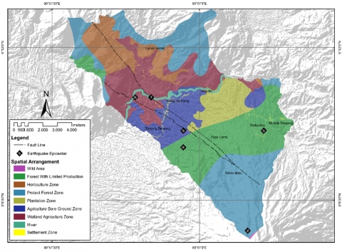
Multiple spatial areas are classified according to the regional spatial map of Pasaman Barat Regency: river borders, protected forest areas, nature reserves, limited production forests, horticultural areas, plantation areas, wetland agricultural areas, and dryland agricultural areas (Figure 10).
The illustration demonstrates the following land uses and areas classified as such: river border (154.06 ha), protected forest area (2923.61 ha), wild areas (79.22 ha), settlements (147.35 ha), limited production forest (1500.12 ha), horticultural area (1450.25 ha), plantation areas (1377.63 ha), agricultural wetland areas (1825.5 ha), and agricultural dry land areas (1727.03 ha), as described in Table 5.
Table 5. The development of the regional spatial pattern in Kajai Village
|
No. |
Spatial Arrangements |
Area (ha) |
|
1 |
Protect Forest Zone |
2923.61 |
|
2 |
Wild Areas |
79.22 |
|
3 |
River Boundary |
154.06 |
|
4 |
Forest with limited production |
1500.12 |
|
5 |
Horticultural area |
1450.25 |
|
6 |
Plantation Area |
1377.63 |
|
7 |
Agricultural Wetland Area |
1825.05 |
|
8 |
Agricultural Dry Land Area |
1727.03 |
|
9 |
Settlements |
147.35 |
Source: Regional Spatial Planning of Pasaman Barat Regency for 2011-2031
Table 6. Evaluation of spatial suitability in earthquake hazard areas
|
Earthquekes Hazard Class |
Spatial Planning Area |
Compatibility |
||
|
Compatible |
According to Conditional |
Not Compatible |
||
|
Stable |
Settlements |
√ |
|
|
|
Wild Areas |
√ |
|
|
|
|
Forest with limited production |
√ |
|
|
|
|
Region of Horticulture |
√ |
|
|
|
|
Protect Forest Zone |
√ |
|
|
|
|
Plantation Area |
√ |
|
|
|
|
Agricultural Wetland Area |
√ |
|
|
|
|
Agricultural Field on Bare Ground |
√ |
|
|
|
|
River Boundary |
√ |
|
|
|
|
Typology A |
Settlements |
|
√ |
|
|
River Boundary |
√ |
|
|
|
|
Forest with limited production |
|
|
√ |
|
|
Region of Horticulture |
|
√ |
|
|
|
Protect Forest Zone |
√ |
|
|
|
|
Plantation Area |
|
√ |
|
|
|
Agricultural Wetland Area |
|
√ |
|
|
|
Agricultural Field on Bare Ground |
|
√ |
|
|
|
Typology B |
Settlements |
|
√ |
|
|
River Boundary |
√ |
|
|
|
|
Forest with limited production |
|
|
√ |
|
|
Region of Horticulture |
|
√ |
|
|
|
Protect Forest Zone |
√ |
|
|
|
|
Plantation Area |
|
√ |
|
|
|
Agricultural Wetland Area |
|
√ |
|
|
|
Agricultural Field on Bare Ground |
|
√ |
|
|
|
Typology C |
Settlements |
|
√ |
|
|
Agricultural Wetland Area |
|
√ |
|
|
|
Agricultural Field on Bare Ground |
|
√ |
|
|
|
River Boundary |
√ |
|
|
|
|
Typology D |
Region of Horticulture |
|
|
√ |
|
Agricultural Field on Bare Ground |
|
|
√ |
|
|
River Boundary |
√ |
|
|
|
Source: Data analysis, 2024
Spatial development planning in Nagari Kajai, as outlined in the Pasaman Barat Regency Spatial Plan for 2012-2032, designates this region as an agricultural zone with local protections. The settlement plan encompasses 147.35 hectares, distributed evenly across the hamlets of Nagari Kajai. However, West Pasaman Regency has yet to incorporate a protected area for earthquake-hazard zones with significant potential in Nagari Kajai. This is highlighted by the numerous transverse faults surrounding the slopes of Mount Talamau and the presence of sediment layers that exhibit weak structures and are prone to weathering [5, 14, 23, 35, 50].
3.3 Evaluation of spatial pattern plans using earthquake hazard in Kajai Village, Pasaman Barat Regency
A comprehensive and sustainable assessment of spatial planning is essential for effective earthquake disaster mitigation [19]. Implementing appropriate strategies within spatial planning can significantly reduce earthquake risks and impacts, protect communities, and enhance regional resilience to disasters [32, 35]. In this context, evaluating Nagari Kajai's spatial planning with a focus on earthquake-prone aspects is central to this study. As shown in Table 5, identified earthquake hazards were classified into categories of building damage in Kajai Village, leading to a spatial planning evaluation that assessed the suitability of land use in the area [27, 51, 52]. This comprehensive approach ensures that the planning process effectively addresses the unique challenges posed by seismic risks and enhances disaster preparedness at the local level [16]. Table 6 shows the results of the assessment based on the earthquake vulnerability class and the Kajai spatial plan.
The assessment reveals that all areas within disaster-hazard zones are categorized based on the principle that spatial pattern planning should avoid earthquake-hazard regions [20]. Consequently, the conditional category emphasizes the need to consider specific conditions and regulations to ensure safety from earthquake disasters [23]. Conversely, the non-conformity category highlights that certain spatial planning activities are prohibited in these areas due to the potential for significant losses and casualties [53]. In Kajai Village, Talamau District, Pasaman Barat Regency, the suitability of spatial patterns in relation to earthquake hazard areas is currently under evaluation [41, 54]. Notably, one area that does not comply with its designated use is a residential zone situated in a high-risk earthquake zone, which poses a considerable threat to life and property [55]. Additionally, residential zones adjacent to agricultural wetlands are classified as Type D, indicating a high vulnerability to seismic activity and a risk of severe to moderate damage [40].
Figure 11. Flow chart of the spatial planning guidelines for the Nagari Kajai earthquake area
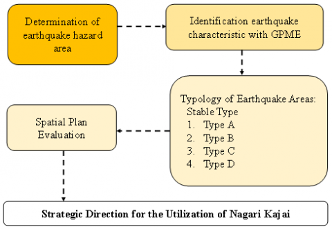
After the assessment process of existing conditions for land use prone to earthquake disasters in Nagari Kajai, a strategic area was determined according to the Spatial Planning Law in Indonesia. The determination of this strategic area is the operational basis for the implementation of space utilization and space utilization control in Nagari Kajai. Figure 11 presents the operational steps for the spatial guidelines for the earthquake area in Nagari Kajai.
The integration of Ground Motion Prediction Equations (GMPE) with Geographic Information Systems (GIS) in this study represents an innovative approach to mapping and analyzing earthquake hazard zones in Pasaman Barat Regency. By quantifying seismic vulnerability through typological classifications (Stable, A–D), the findings offer a scientific basis for revising spatial planning regulations. The study reveals significant mismatches between current land-use designations and hazard-prone zones, particularly residential and agricultural areas within Typology C and D zones. These insights directly inform spatial planning policy by identifying areas requiring development restrictions or retrofitting standards. Furthermore, the GMPE-GIS framework allows for replicable application in other high-risk regions, supporting proactive disaster mitigation. Policymakers are urged to integrate these hazard assessments into local spatial plans to enhance resilience and reduce seismic risks in rural settlements.
Thanks to the Institute for Research and Community Service (LPPM) of Universitas Negeri Padang for supporting research funds in the contract with the Rector’s Decree No. 238/UN.35/LT/2022. The research has no intention or conflict of interest toward individuals or groups.
[1] Tocchi, G., Cremen, G., Galasso, C., Polese, M. (2025). Integrating multi-hazard, socio-physical information in a holistic index for decision making on disaster risk reduction. International Journal of Disaster Risk Reduction, 124: 105494. https://doi.org/10.1016/j.ijdrr.2025.105494
[2] Agus, C., Suratman, A.B.S., Hasanah, N.A.I., Primananda, E., Nugraheni, M., Darmajati, Y. (2021). Integrated multi-hazards management for mitigation of multi disaster in tropical ecosystem in Indonesia. Preprint.
[3] Handayani, T., Semedi, J.M., Suro, S.M. (2019). Identification of suitable location for expansion of fish aggregating devices (FADs) for fishermen on Pacitan Open Sea, Indonesia. International Journal of GEOMATE, 16(56): 183-190. https://doi.org/10.21660/2019.56.4822
[4] Fayaz, M., Romshoo, S., Rashid, I., Chandra, R. (2022). Earthquake vulnerability assessment of the built environment in Srinagar City, Kashmir Himalaya, using GIS. Natural Hazards and Earth System Sciences, 23: 1593-1611. https://doi.org/10.5194/nhess-23-1593-2023
[5] Arifin, S., Wicaksono, S.S., Sumarto, S., Martitah, M., Sulistianingsih, D. (2021). Disaster resilient village-based approach to disaster risk reduction policy in Indonesia: A regulatory analysis. Jàmbá: Journal of Disaster Risk Studies, 13(1): 1-9. https://doi.org/10.4102/jamba.v13i1.1021
[6] Kusumastuti, R.D., Husodo, Z.A., Suardi, L., Danarsari, D.N. (2014). Developing a resilience index towards natural disasters in Indonesia. International Journal of Disaster Risk Reduction, 10: 327-340. https://doi.org/10.1016/j.ijdrr.2014.10.007
[7] Caesario, D., Aulia, B., Maiyudi, R., Khorniawan, W.B., Jayanti, A.G.R. (2024). An understanding of volcanic deposits with two dimensional electrical resistivity imaging survey at Talamau Mountain West Pasaman, Indonesia. Sumatra Journal of Disaster, Geography and Geography Education, 8(1): 37-45.
[8] Pasari, S., Simanjuntak, A.V., Mehta, A., Neha, Sharma, Y. (2021). A synoptic view of the natural time distribution and contemporary earthquake hazards in Sumatra, Indonesia. Natural Hazards, 108(1): 309-321. https://doi.org/10.1007/s11069-021-04682-0
[9] Rafie, M.T., Sahara, D.P., Cummins, P.R., Triyoso, W., Widiyantoro, S. (2023). Stress accumulation and earthquake activity on the Great Sumatran Fault, Indonesia. Natural Hazards, 116(3): 3401-3425. https://doi.org/10.1007/s11069-023-05816-2
[10] Suasti, Y., Caesario, D., Prihantarto, W.J., Susetyo, B.B., Iskarni, P. (2024). Development of active fault mapping method using geoelectric and geographical information system. International Journal of GEOMATE, 26(116): 72-84. https://doi.org/10.21660/2024.116.4360
[11] Departemen Pekerjaan Umum. (2007). Regulation of the Minister of Public Works Number: 21/PRT/M/2007 concerning guidelines for spatial planning of volcanic eruption-prone areas and earthquake-prone areas. https://jdih.acehprov.go.id/dih/detail/10682b9a-81e5-4db9-bb32-adcc6add0f56.
[12] Nasional, B.S. (2012). Tata cara perencanaan ketahanan gempa untuk struktur bangunan gedung dan non gedung. Sni, 1726: 2012.
[13] Khalid, F., Razbin, M. (2024). Modeling peak ground acceleration for earthquake hazard safety evaluation. Scientific Reports, 14: 31032. https://doi.org/10.1038/s41598-024-82171-7
[14] Pramono, S., Prakoso, W.A., Rohadi, S., Karnawati, D., Santoso, E., Nurfajar, A. (2020). Influence of seismicity declustering on ground motion prediction equations for Central Sulawesi seismic region. International Journal of GEOMATE, 19(71): 61-68. https://doi.org/10.21660/2020.71.28369
[15] Wirth, E.A., Sahakian, V.J., Wallace, L.M., Melnick, D. (2022). The occurrence and hazards of great subduction zone earthquakes. Nature Reviews Earth & Environment, 3(2): 125-140. https://doi.org/10.1038/s43017-021-00245-w
[16] Devi, R., Sastry, R.G., Samadhiya, N.K. (2017). Assessment of soil-liquefaction potential based on geoelectrical imaging: A case study. Geophysics, 82(6): B231-B243. https://doi.org/10.1190/geo2017-0016.1
[17] Chun, K.P., Octavianti, T., Dogulu, N., Tyralis, H., et al. (2025). Transforming disaster risk reduction with AI and big data: Legal and interdisciplinary perspectives. Wiley Interdisciplinary Reviews: Data Mining and Knowledge Discovery, 15(2): e70011. https://doi.org/10.1002/widm.70011
[18] Chen, J., Li, J., He, J., Li, Z. (2002). Development of geographic information systems (GIS) in China: An overview. Photogrammetric Engineering and Remote Sensing, 68(4): 325-332.
[19] Tallini, M., Morana, E., Guerriero, V., Di Giulio, G., Vassallo, M. (2024). Seismic microzonation mapping for urban and land sustainable planning in high seismicity areas (L’aquila municipality, Central Italy): The contribution of 2D modeling for the evaluation of the amplification factors. Sustainability, 16(19): 8401. https://doi.org/10.3390/su16198401
[20] Budiman, H., Mashdurohatun, A., Suparman, E. (2020). Factors influencing the implementation of spatial planning policy in the regions (a case study in Region III Cirebon). In International Conference on Law, Economics and Health (ICLEH 2020), pp. 113-118. https://doi.org/10.2991/aebmr.k.200513.023
[21] Aditya, T., Santosa, P.B., Yulaikhah, Y., Widjajanti, N., Atunggal, D., Sulistyawati, M. (2021). Validation and collaborative mapping to accelerate quality assurance of land registration. Land Use Policy, 109: 105689. https://doi.org/10.1016/j.landusepol.2021.105689
[22] Kawabe, T., Kashiyama, K., Okawa, H., Miyachi, H. (2013). Development of simulation system for tsunami evacuation using virtual reality technology. In Proc. of the 5th Asia Pacific Congress on Computational Mechanics, Paper (No. 1418).
[23] Erwindy, J., Asdak, C., Suganda, B.R., Hadian, M.S.D. (2021). Integrated assessment of Urban Land Carrying Capacity (ULCC) for reducing earthquake risk risaster in Palu City. Research Square. https://doi.org/10.21203/rs.3.rs-764274/v1
[24] Omar, M.J., Ismaeel, E.H., Mustafa, F.A. (2022). Long-term expansion plan of intermediate cities using GIS: The case of Sinjar city, Iraq. International Journal of Sustainable Development and Planning, 17(3): 863-873. https://doi.org/10.18280/ijsdp.170316
[25] Elubid, B.A., Huang, T., Ahmed, E.H., Zhao, J., Elhag, K.M., Abbass, W., Babiker, M.M. (2019). Geospatial distributions of groundwater quality in Gedaref State using geographic information system (GIS) and drinking water quality index (DWQI). International Journal of Environmental Research and Public Health, 16(5): 731. https://doi.org/10.3390/ijerph16050731
[26] Debnath, R. (2013). An assessment of spatio-temporal pattern of urban earthquake vulnerability using GIS: A study on Dhaka City. Annals of GIS, 19(2): 63-78. https://doi.org/10.1080/19475683.2013.782468
[27] Barua, U., Ansary, M.A., Islam, I., Munawar, H.S., Mojtahedi, M. (2023). Multi-criteria earthquake risk sensitivity mapping at the local level for sustainable risk-sensitive land use planning (RSLUP). Sustainability, 15(9): 7518. https://doi.org/10.3390/su15097518
[28] Morante-Carballo, F., Pinto-Ponce, B., Santos-Baquerizo, E., Briones-Bitar, J., Berrezueta, E., Carrión-Mero, P. (2024). Systematic review on seismic hazards in the coastal regions of the pacific ring of fire. International Journal of Safety and Security Engineering, 14(5): 1591-1605. https://doi.org/10.18280/ijsse.140526
[29] Rizal, J., Gunawan, A.Y., Indratno, S.W., Meilano, I. (2023). Seismic activity analysis of five major earthquake source segments in the Sumatra megathrust zone: Each segment and two adjacent segments points of view. Bulletin of the New Zealand Society for Earthquake Engineering, 56(2): 55-70. https://doi.org/10.5459/bnzsee.1555
[30] Supendi, P., Widiyantoro, S., Rawlinson, N., Yatimantoro, T., et al. (2023). On the potential for megathrust earthquakes and tsunamis off the southern coast of West Java and southeast Sumatra, Indonesia. Natural Hazards, 116(1): 1315-1328. https://doi.org/10.1007/s11069-022-05696-y
[31] Sasikirana, L., Syaiim, A.N.M., Al Mubarok, F. (2021). The importance of natural disaster insurance in Indonesia. International Research of Economic and Management Education, 1(2): 94-104.
[32] Firdhous, M.F.M., Karuratane, P.M. (2018). A model for enhancing the role of information and communication technologies for improving the resilience of rural communities to disasters. Procedia Engineering, 212: 707-714. https://doi.org/10.1016/j.proeng.2018.01.091
[33] Işık, E., Avcil, F., Büyüksaraç, A., Arkan, E., Harirchian, E. (2025). Impact of local soil conditions on the seismic performance of reinforced concrete structures: In the context of the 2023 Kahramanmaraş Earthquakes. Applied Sciences, 15(5): 2389. https://doi.org/10.3390/app15052389
[34] Birkmann, J., Cardona, O.D., Carreño, M.L., Barbat, A.H., Pelling, M., Schneiderbauer, S., Kienberger, S., Keiler, M., Alexander, D., Zeil, P., Welle, T. (2013). Framing vulnerability, risk and societal responses: The MOVE framework. Natural Hazards, 67(2): 193-211. https://doi.org/10.1007/s11069-013-0558-5
[35] Cutter, S.L., Burton, C.G., Emrich, C.T. (2010). Disaster resilience indicators for benchmarking baseline conditions. Journal of Homeland Security and Emergency Management, 7(1). https://doi.org/10.2202/1547-7355.1732
[36] Wisner, B., Gaillard, J.C., Kelman, I. (2012). The Routledge Handbook of Hazards and Disaster Risk Reduction (Vol. 2). London: Routledge.
[37] Spence, R. (2007). Earthquake disaster scenario prediction and loss modelling for urban areas. LESSLOSS Report, 7: 165.
[38] Octhav, A., Julius, A.M., Muzli, M., Rudyanto, A. (2017). Modified of ground motion prediction equation in Indonesia, case study: South and South-East of Sulawesi at 2011-2015. AIP Conference Proceedings, 1857(1): 020003. https://doi.org/10.1063/1.4987045
[39] Nakano, M., Kumagai, H., Toda, S., Ando, R., Yamashina, T., Inoue, H., Sunarjo. (2010). Source model of an earthquake doublet that occurred in a pull-apart basin along the Sumatran fault, Indonesia. Geophysical Journal International, 181(1): 141-153. https://doi.org/10.1111/j.1365-246X.2010.04511.x
[40] Imani, R., Kurniawan, H., Sahputra, D.E. (2022). Identification of damage levels of residents’ houses due to earthquake in Pasaman 2022. Civil Engineering Collaboration, 7(2): 73-79. https://doi.org/10.35134/jcivil.v7i2.46
[41] Qin, Y., Zhang, D., Zheng, W., Liu, B., Gong, Z. (2024). Spatial distribution of near-fault landslides along Litang fault zones, eastern Tibetan Plateau. Geomorphology, 455: 109189. https://doi.org/10.1016/j.geomorph.2024.109189
[42] Dewanto, B.G., Priadi, R., Heliani, L.S., Natul, A.S., Yanis, M., Suhendro, I., Julius, A.M. (2022). The 2022 Mw 6.1 Pasaman Barat, Indonesia Earthquake, confirmed the existence of the talamau segment fault based on teleseismic and satellite gravity data. Quaternary, 5(4): 45. https://doi.org/10.3390/quat5040045
[43] Jihad, A., Umar, M., Ramli, M., Banyunegoro, V.H. (2023). Analysis of change of seismic stress along the Sumatran zone to predict potential earthquake zones. GEOMATE Journal, 24(104): 36-43.
[44] Bhat, M.A., Shah, R.M., Ahmad, B. (2011). Cloud Computing: A solution to Geographical Information Systems (GIS). International Journal on Computer Science and Engineering, 3(2): 594-600.
[45] Alfaqih, T.M., Hassan, M.M. (2016). GIS Cloud: Integration between cloud things and geographic information systems (GIS) opportunities and challenges. International Journal on Computer Science and Engineering (IJCSE), 3(5): 360-365.
[46] Quigley, M.C., Saunders, W., Massey, C., Van Dissen, R., Villamor, P., Jack, H., Litchfield, N. (2020). The utility of earth science information in post-earthquake land-use decision-making: The 2010–2011 Canterbury earthquake sequence in Aotearoa New Zealand. Natural Hazards and Earth System Sciences, 20(12): 3361-3385. https://doi.org/10.5194/nhess-20-3361-2020
[47] Sekarsari, R.W., Wijaya, A.F. (2014). Spatial planning in perspective of good governance (a study on analysis of spatial planning in Batu City as a tourism city). Journal of Indonesian Tourism and Development Studies, 2(1): 10-18. https://doi.org/10.21776/ub.jitode.2014.002.01.02
[48] Rahmawati, R., Supriatna, T., Lukman, S., Daraba, D. (2021). Planning strategy spatial plan for the province of Central Kalimantan. Budapest International Research and Critics Institute-Journal (BIRCI-Journal), 4(4): 8705-8715. https://doi.org/10.33258/birci.v4i4.2819
[49] Tampubolon, D., Irsan, M., Harlen, Mardiana, Handoko, T. (2022). Preference of spatial mobility and reside in the suburbs Indonesia. International Journal of Sustainable Development and Planning, 17(5): 1479-1487. https://doi.org/10.18280/ijsdp.170512
[50] Lee, T., Fukumori, I., Menemenlis, D., Xing, Z., Fu, L.L. (2002). Effects of the Indonesian throughflow on the Pacific and Indian Oceans. Journal of Physical Oceanography, 32(5): 1404-1429. https://doi.org/10.1175/1520-0485(2002)032%3C1404:EOTITO%3E2.0.CO;2
[51] Asori, M., Adu, P. (2023). Modeling the impact of the future state of land use land cover change patterns on land surface temperatures beyond the frontiers of greater Kumasi: A coupled cellular automaton (CA) and Markov chains approaches. Remote Sensing Applications: Society and Environment, 29: 100908. https://doi.org/10.1016/j.rsase.2022.100908
[52] Guo, J., Shen, B., Li, H., Wang, Y., Tuvshintogtokh, I., Niu, J., Potter, M.A., Li, F.Y. (2024). Past dynamics and future prediction of the impacts of land use cover change and climate change on landscape ecological risk across the Mongolian plateau. Journal of Environmental Management, 355: 120365. https://doi.org/10.1016/j.jenvman.2024.120365
[53] Carol, N.D., Ismail, F.A., Narny, Y. (2023). Implementation of a quick assessment application called InaRISK for damaged houses after the West Pasaman Earthquake (2022). IOP Conference Series: Earth and Environmental Science, 1244(1): 012041. https://doi.org/10.1088/1755-1315/1244/1/012041
[54] Fajria, R., Putera, R.E., Ariany, R. (2023). An evaluation of the implementation of the disaster resilient village program in Padang Pariaman regency. E3S Web of Conferences, 464: 10001. https://doi.org/10.1051/e3sconf/202346410001
[55] Wang, H., Liu, Y., Zhang, G., Wang, Y., Zhao, J. (2021). Multi-scenario simulation of urban growth under integrated urban spatial planning: A case study of Wuhan, China. Sustainability, 13(20): 11279. https://doi.org/10.3390/su132011279