Assessing the Impact of Road Construction on the Sumatran Orangutan (Pongo abelii) Habitat in Pakpak Bharat District from 2003 to 2022

Nurdin Sulistiyono*![]() | Ainun Zahirah
| Ainun Zahirah![]()
© 2024 The authors. This article is published by IIETA and is licensed under the CC BY 4.0 license (http://creativecommons.org/licenses/by/4.0/).
OPEN ACCESS
The Pakpak Bharat Regency is essential to the Sumatran Orangutan's ecosystem. The Sumatran Orangutan protects other plants and animals in the forest ecosystem as an umbrella species. Unfortunately, species are listed as Critically Endangered due to habitat fragmentation, exploitation, and conversion to other land uses. Lagan-Pagindar Road construction cutting through forest areas in Pakpak Bharat impacts the fragmentation of the Sumatran Orangutan habitat. This study aims to evaluate the landscape structure of the impact of the Lagan-Pagindar Road construction on the Sumatran Orangutan habitat. The methods used are land cover analysis by supervised classification in ArcMap10.8, distance from human activity areas using Euclidean distance tools in ArcMap10.8, and spatial fragmentation analysis using landscape metric by patch analyst Extension ArcGIS. Land cover change of the Sumatran Orangutan habitat between 2003 and 2022 shows an increase in the area of land cover classes related to human activities. The impact of the Lagan-Pagindar Road has caused the Sumatran Orangutan's habitat to become fragmented. The threat of habitat fragmentation must be minimized by mitigating the impact of road construction. Planning and conducting a thorough assessment of infrastructure development is necessary to minimize the adverse effects of conserving Sumatran Orangutan.
ecological landscape, habitat fragmentation, landscape metrics, road construction, Sumatran Orangutan
Orangutans are the only great ape in Asia, and they can currently be found only in several areas in Indonesia and Malaysia [1]. Orangutans are arboreal and semi-solitary animals that eat fruit (frugivores) and range over a wide distribution area [2]. This behavior allows orangutans to become seed dispersers, essential in maintaining forest regeneration as an umbrella species that protects other plants and animals in the forest ecosystem [3]. Currently, the Sumatran Orangutan (Pongo abelii) is classified in the Critically Endangered category by the IUCN (The International Union for Conservation of Nature) [4]. The decline in orangutan populations is primarily caused by habitat fragmentation, massive exploitation, and conversion into plantations and other land use [5]. The extinction of orangutans in an ecosystem can cause a reduction in the number of plant seeds spread by orangutans, which can deplete the forest and endanger the existence of other animals [2].
Pakpak Bharat ecologically has functions as an integral part of the habitat of orangutans in the Leuser Ecosystem [6]. As an expansion area, Pakpak Bharat Regency is trying to increase development in its administrative area by utilizing available forest resources [7]. In 2012, the Lagan-Pagindar Road was built by the Pakpak Bharat Regency Government to equitable infrastructure development, but the road cuts through forest areas [8] and be upgraded to an arterial or collector road function [9]. It is feared that small-scale logging from communities that are currently ongoing will destroy wildlife habitats in the area, including wild orangutans [6]. The unwise implementation of development, pressure of population growth, migration, and change land use raises the risk of habitat and ecosystem fragmentation [10].
The value of changes in land cover and landscape metrics can evidence changes in landscape structure. It is assumed that the construction of the Lagan-Pagindar Road cutting through forest areas in Pakpak Bharat impacts the Sumatran Orangutan habitat, causing fragmentation of the Sumatran Orangutan habitat. This assumption is based on the understanding that changes in landscape structure can occur due to anthropogenic factors affecting regional development. The research is also beginning to reveal that habitat fragmentation is a concomitant change in degradation and habitat loss that can be observed in landscapes modified by humans. The intention is to determine the occurrence of Sumatran Orangutan habitat fragmentation so that area managers can mitigate the impact of road construction and pay more attention to the conservation of Sumatran orangutans. This study aims to quantify of land cover change and forest landscape structure within orangutan habitats in Pakpak Bharat Regency between 2003 and 2022, focusing on the impact of the Lagan-Pagindar Road construction.
2.1 Research time and location
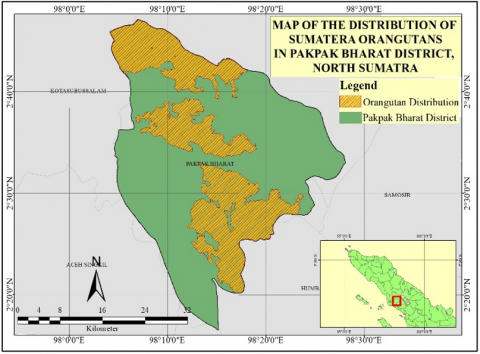
This research was carried out from March to June 2023. The research location was carried out in the Pakpak Bharat Regency, Indonesia (Figure 1).
Figure 1. Map of research location
2.2 Research materials and equipment
The tools used in this research were a laptop, camera, GPS (Global Positioning System), and writing equipment. The software used is ArcMap 10.8, QGIS, Patch Analyst, Avenza Maps, Microsoft Office, and Google Earth. The materials used in this research are Landsat 5 Thematic Mapper (TM) imagery, Landsat 7 Enhanced Thematic Mapper Plus (ETM+) imagery and Landsat 8 Operational Land Imager (OLI) imagery, covering the area used as an Area of Interest (AOI), data of the Lagan-Pagindar Road, administrative map of Pakpak Bharat district, data on the distribution of Sumatran Orangutans at the research location and road network data.
2.3 Research procedures
2.3.1 Data collection
Primary data was obtained through researcher observations in the field, including ground check of land cover classes and observe Lagan-Pagindar Road. Secondary data was obtained indirectly, from related agencies or institutions and through studies/literature reviews from various sources.
2.3.2 Data processing and data analysis
(1) Analysis of land cover in Pakpak Bharat Regency and Orangutan habitat
Land cover was obtained in 2003 to describe land cover conditions at the beginning of the expansion of Pakpak Bharat Regency, in 2011 to describe land cover conditions before road construction in forest areas, and in 2022 after road construction in forest areas. Classification in the land cover analysis is carried out by supervised method (Maximum Likelihood) creating a Training Area (information from each pixel in the land cover class), which has been obtained through groundcheck and Google Earth images.
Ground check is carried out by determining points based on purposive sampling, representing the entire area with 503 points. There are ten land cover types regarding the Regulation of the Director General of Forestry Planning and Environmental Management No. 01/Juknis/IPSDH/2015 primary dryland forest, secondary dry land forest, plantation forest, shrubs, plantation, settlement, open ground, water body, agriculture, and rice field.
Table 1. Landscape metrics to the landscape structure of orangutan habitat
|
Metric Landscape |
Formula |
Description |
|
Total Core Area (TCA) |
$\mathrm{TCA}=\sum_{j=1}^n a i j^c\left(\frac{1}{10000}\right)$ |
Total core area |
|
Mean Patch Size (MPS) |
$M P S=\frac{\sum_{j=1}^n a i j}{n i}\left(\frac{1}{10000}\right)$ |
Average patch shape |
|
Number of Patches (NumP) |
NP = ni |
Number of patches |
|
Patch Density (PD) |
$P D=\frac{n_i}{A}(10000)(100)$ |
Patch density |
|
Total Edge (TE) |
$T E=\sum_{k=1}^m e_{i k}$ |
The total number of edges |
|
Edge Density (ED) |
$E D=\frac{\sum_{k=1}^m e_{i k}}{A}(10000)$ |
Edge density |
|
Mean Shape Index (MSI) |
$M S I=\frac{\sum_{j=1}^n\left(\frac{P i j}{2 \sqrt{\pi a_{i j}}}\right)}{n i}$ |
Patch shape irregularity index |
|
Area weighted- Mean Shape Index (AWMSI) |
$\begin{aligned} & A W M S =\sum_{i=1}^n\left[\left(\frac{p_{i j}}{2 \sqrt{\pi a_{i j}}}\right) \frac{a_{i j}}{\sum_{j=1}^n a_{i j}}\right]\end{aligned}$ |
Patch shape complexity index |
|
Mean Patch Fractal Dimension (MPFD) |
$\operatorname{MPFD}=\frac{\sum_{j=1}^n\left(\frac{2 \ln P_{i j}}{\ln a_{i j}}\right)}{n_i}$ |
Patch shape complexity index |
where,
TCA = Total core area of each class (ha)
$a i j^c$ = Core area (m2) patch ij based on the specified buffer width (m)
C = Buffer area is usually 50 m
MPS = Average patch size (ha)
ni = Number of patches in class (units)
$a i j$ = patch area ij (m2)
PD = Patch density
A = Landscape area (ha)
TE = Total Edge (m)
$e_{i k}$ = total length (m) of edges in the landscape between patch types (classes) i
ED = Number of Edges (meters/ha)
MSI = Average patch shape
Pij = Perimeter (m) of patch ij
AWMSI = Area-weighted average shape index
MPFD = Average value of patch fractal dimension
The percentage of mapping accuracy can be determined using kappa accuracy or the kappa index [11]. The level of accuracy of land cover classification results has been determined by the United States Geological Survey (USGS)is more than 85% [12]. Accuracy calculation is a step to determine whether or not the image classification results are appropriate according to conditions in the field. Then, the results of the land cover class of the Pakpak Bharat Regency were obtained. The land cover map in the Sumatran orangutan distribution area was obtained by cutting the land cover map of Pakpak Bharat Regency with the Sumatran Orangutan distribution polygon.
(2) Map of distance Orangutan habitat from human activity areas.
The distance map of orangutan habitat from areas of human activity includes distance from roads, settlements, agriculture, and plantations. Distance maps are created using ArcMap’s Euclidean distance tool.
(3) Spatial Fragmentation Analysis
Determination of habitat fragmentation analysis at class level using landscape matrix analysis [13-15] as in Table 1.
(4) Analysis of Land Cover and Landscape Changes
The percentage change in area over the analysis period is formulated as Eq. (1) [16].
$\%$ Change $=\frac{\text { area/unit last year }- \text { area/unit first year }}{\text { area/unit first year }} \times 100$ (1)
(5) Analysis of Changes in Land Cover and Landscape Structure Around Roads
Land cover analysis around the road was carried out by creating land cover on a 2000-meter road buffer to see changes in land cover on either side of the road. The land cover results are also used to see changes in land cover in edge the Sumatran Orangutan habitat in Pakpak Bharat Regency. The distance from the road was created using the Euclidean distance tool to calculate the distance from the road to the Sumatran Orangutan habitat and calculate landscape metrics for the Sumatran Orangutan habitat around Lagan–Pagindar Road.
3.1 Habitat of the Sumatran Orangutan (Pongo abelii) in Pakpak Bharat Regency
The area of the research area from the spatial analysis result is 132,448.5 ha. The habitat of the Sumatran Orangutan found in Pakpak Bharat Regency includes 3 metapopulation areas [17]. The Sumatran Orangutan metapopulation in Pakpak Bharat Regency includes the Batu Ardan, Siranggas, and Sikulaping. Pakpak Bharat are also the central populations of Sumatran Orangutans outside the Leuser Ecosystem [18]. The distribution area of Sumatran Orangutans in the Pakpak Bharat Regency is 46,974.8 Ha or 35.5% of the total area of the Pakpak Bharat Regency. The total population of Sumatran Orangutans in Sikulaping is 260 individuals with an area of 349.5 km2 and in Siranggas/Batu Ardan is 90 individuals with an area of 559.4 km2 with low life sustainability projections [2]. The Sumatran Orangutan population density in Siranggas is higher than in Batu Ardan [19].
3.2 Analysis of land cover changes in Pakpak Bharat Regency
The land cover classification results produce 10 types of land cover: primary dry land forest, secondary dry land forest, plantation forest, shrubs, plantations, settlements, open land, water bodies, agriculture and rice fields. The Kappa Accuracy value of the land cover classification results was 86.55%. The land cover dominate in Pakpak Bharat Regency are primary dryland forest, secondary dry land forest, and plantation forests (Table 2). This is also proven by the extent of the forest area in Pakpak Bharat Regency based on the Decree of the Indonesia Minister of Forestry No.579/MENHUT-II/2014.
The other classes than forest that dominated in 2003 were agriculture, which covered 8,545.8 Ha (6.5%), and open land covering an area of 4,611.5 Ha (3.5%), in 2011 and 2022, agriculture and shrubs. The agricultural class covered an area of 8,716.5 Ha (6.6%) in 2011, an area of 9,498.0 Ha (7.2%) in 2022 and for the shrub class, an area of 7,905.5 Ha (6.0%) in 2011, an area of 6,508.3 Ha (4.9%) in 2022. Land cover changes in Pakpak Bharat between 2003 and 2022 showed the most significant decrease in land cover area was open land covering an area of 3,605.2 Ha (78.2%) and rice fields covering an area of 218.4 Ha (17.4%). Meanwhile, the most significant increase in land cover area were settlements covering an area of 624.2 Ha (218.5%), shrubs covering an area of 3,164 Ha (94.6%), and plantations covering an area of 1,313.46 Ha (80.0%).
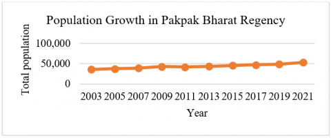
The agricultural land cover class that dominates in the Pakpak Bharat Regency is caused by the majority of Pakpak Bharat people's livelihoods being farmers (Figure 2) [20]. The population density of an area can influences the potential for environmental damage, the higher the population density, the more land the community needs [21].
Figure 2. Pakpak Bharat population growth trend
Table 2. Land cover class of Pakpak Bharat Regency in 2003, 2011 and 2022
|
No. |
Land Cover Class |
2003 |
2011 |
2022 |
|||
|
Area (ha) |
Percentage (%) |
Area (ha) |
Percentage (%) |
Area (ha) |
Percentage (%) |
||
|
1. |
Primary dryland forest |
60,077.0 |
45.7 |
63,671.9 |
48.1 |
60,145.3 |
45.4 |
|
2. |
Secondary dry land forest |
39,345.4 |
29.7 |
33,181.7 |
25.1 |
36,449.4 |
27.5 |
|
3. |
Plantation forest |
12,928.0 |
9.8 |
13,792.0 |
10.4 |
13,474.6 |
10.2 |
|
4. |
Shrubs |
3,344.0 |
2.5 |
7,905.5 |
6.0 |
6,508.3 |
4.9 |
|
5. |
Plantation |
1,641.3 |
1.2 |
2,103.7 |
1.6 |
2,954.8 |
2.2 |
|
6. |
Settlement |
285.6 |
0.2 |
547.8 |
0.4 |
909.8 |
0.7 |
|
7. |
Open ground |
4,611.5 |
3.5 |
685.4 |
0.5 |
1,006.3 |
0.8 |
|
8. |
Water body |
416.0 |
0.3 |
326.2 |
0.3 |
466.5 |
0.4 |
|
9. |
Agriculture |
8,545.8 |
6.5 |
8,716.5 |
6.6 |
9,498.0 |
7.2 |
|
10. |
Ricefield |
1,253.9 |
1.0 |
1,517.6 |
1.2 |
1,035.5 |
0.8 |
|
Total |
132,448.5 |
100 |
132,448.5 |
100 |
132,448.5 |
100 |
|
Table 3. Sumatran Orangutan habitat land cover class in Pakpak Bharat Regency in 2003, 2011, and 2022
|
No. |
Land Cover Class |
2003 |
2011 |
2022 |
|||
|
Area (Ha) |
Percentage (%) |
Area (Ha) |
Percentage (%) |
Area (Ha) |
Percentage (%) |
||
|
1. |
Primary dryland forest |
37,548.7 |
79.9 |
39,223.4 |
83.5 |
38,516.2 |
82.0 |
|
2. |
Secondary dry land forest |
7,422.0 |
15.8 |
5,415.9 |
11.5 |
5,468.3 |
11.6 |
|
3. |
Plantation forest |
1,808.8 |
3.9 |
2,209.7 |
4.7 |
2,589.9 |
5.5 |
|
4. |
Shrubs |
43.8 |
0.1 |
63.2 |
0.1 |
235.2 |
0.5 |
|
5. |
Plantation |
2.0 |
0.0 |
15.5 |
0.0 |
28.6 |
0.1 |
|
6. |
Settlement |
3.8 |
0.0 |
1.3 |
0.0 |
13.6 |
0.0 |
|
7. |
Open ground |
93.9 |
0.0 |
9.9 |
0.0 |
4.3 |
0.0 |
|
8. |
Water body |
19.1 |
0.0 |
13.9 |
0.0 |
33.4 |
0.1 |
|
9. |
Agriculture |
29.1 |
0.1 |
19.0 |
0.0 |
69.5 |
0.2 |
|
10. |
Ricefield |
3.7 |
0.0 |
2.8 |
0.0 |
15.7 |
0.0 |
|
Total |
46,974.8 |
100 |
46,974.8 |
100 |
46,974.8 |
100 |
|
3.3 Distribution of Sumatran Orangutans based on land cover type
The type of land cover distribution of Sumatran Orangutans in 2003 was dominated by primary dry land forest, covering an area of 37,548.7 Ha (79.9%), 39,223.4 Ha (83.5%) in 2011, and 38,516.2 Ha (82.0%) in 2022. The next dominant land cover is secondary dry land forest covering an area of 7,422.0 Ha (15.8%) in 2003, 5,415.9 Ha (11.5%) in 2011, and 5,468.3 Ha (11.6%) in 2022. The land cover classes of open land and secondary dry land forest have experienced the largest decline from 2003 to 2022 (Table 3 and Figure 3). The decline in open land area decreased by 95.4% and secondary dry land forest by 26.3%, while increase in area was in the plantation class by 1309.9% and shrubs by 436.6%.
Figure 3. Land cover map of Sumatran Orangutan habitat
Changes in the land cover classes of the Sumatran Orangutan habitat show an increase in the area of land cover classes related to human activities such as settlements, plantations, and agriculture. It is feared that human activities in the Sumatran Orangutan habitat will threaten to the lives of the Sumatran Orangutan, such as narrowing or reducing the size of the habitat, fragmentation, and even conflict between orangutans and humans. Changes in habitat function to non-forest and disturbance from human activities influence the decline in wild animal populations [22].
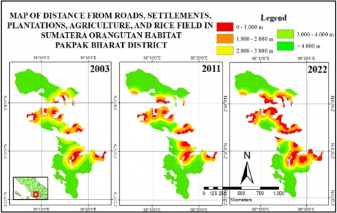
3.4 Analysis of the distance of Sumatran Orangutan habitat from human activity areas
Areas of human activity include roads, plantations, settlements, agriculture, and rice fields. With increasingly open road access, it will be easier for people to open up forest- areas or land for various purposes. Areas of human activity such as plantations, settlements, agriculture and rice fields threaten to Orangutan habitat (Figure 4).
Figure 4. Map of the distance between orangutan habitat and human activity areas
Table 4. Distance of Sumatran Orangutan habitat from human activity areas
|
No. |
Distance Range Value (m) |
2003 |
2011 |
2022 |
||||
|
Area (ha) |
Percentage (%) |
Area (ha) |
Percentage (%) |
Area (ha) |
Percentage (%) |
|||
|
1. |
0 - 1000 |
3,198.8 |
6.8 |
4,091.2 |
8.7 |
8,278.6 |
17.6 |
|
|
2. |
1000 - 2000 |
6,583.6 |
14.0 |
7,251.8 |
15.4 |
8,992.0 |
19.1 |
|
|
3. |
2000 - 3000 |
6,168.2 |
13,1 |
5,768.4 |
12.9 |
6,415.4 |
13.7 |
|
|
4. |
3000 - 4000 |
6,170.5 |
13,1 |
6,000.1 |
12.8 |
5,700.1 |
12,1 |
|
|
5. |
> 4000 |
24,853.7 |
52.9 |
23,863.3 |
50.8 |
17,588.7 |
37.4 |
|
|
Total |
46,974.8 |
100 |
46,974.8 |
100 |
46,974.8 |
100 |
||
Sumatran Orangutan habitat in areas of human activity with a distance of 0–1000 m experienced an increase in area from 2003 to 2022 by 158.9%, while distances > 4000 m experienced a decrease in area of 29.2% (Table 4). The proximity of the Sumatran Orangutan habitat to areas of human activity indicates that there are indications of human activity on the edge of the Sumatran Orangutan habitat, which is feared to pose a threat to the Orangutan. Human activities and the ever-increasing population in forest fringe areas will encourage the growth of residential areas and local agriculture around forest areas, resulting in the loss of forest area [23]. The human-orangutan conflict can occur if the orangutan habitat is disturbed due to human activity. Human-wildlife conflicts often occur when humans carry out activities in wildlife habitats [21].
3.5 Evaluation of landscape and habitat fragmentation coverage at the class scale
Landscape metric evaluation is used to determine indicators of fragmentation of a habitat. Land cover classification is divided into 3 categories: forest class, plantation forest, and non-forest class. Forest class includes natural forest land cover classes (primary and secondary dry land forest). The plantation forest class only includes the plantation forest class. The non-forest class includes the land cover classes of shrubs, plantations, settlements, open land, water bodies, agriculture and rice fields.
Primates are generally interior species that require the core area more than the edges and are usually very sensitive to disturbance from human activities [24]. This buffer is also used to determine the core area of the Sumatran Orangutan habitat with landscape metrics. Buffer used with 50 m [13]. The land cover classification map in the Sumatran Orangutan habitat is presented in Figure 5.
Figure 5. Orangutan habitat land cover classification map
Figure 6. Forest class landscape metrics: (a) Total core area, (b) Average patch size, (c) Number of patches and patch density, (d) Total edge area, (e) Edge density and weighted average shape index, (f) Average shape size index
Analysis of landscape metrics shows that the core area of the Sumatran Orangutan Forest habitat class in 2003 was 43,476.4 Ha, in 2011 was 43,425.7 Ha, and in 2022 was 41,296.4 Ha, the core forest area is decreasing from year to year. The total core area (TCA) loss from 2003 to 2022 in the Sumatran Orangutan Forest habitat class was 5.01%. Figure 6 showed the results of the metric analysis of the forest landscape in the Sumatran Orangutan habitat.
Orangutan habitat requires high security, so orangutans choose places difficult for humans to reach. Therefore, orangutans usually protect themselves in the middle or core of a habitat pocket (patch). In general, "habitat loss" describes a reduction in the spatial area of natural habitat, including forests. Meanwhile, habitat fragmentation is the breakdown of habitat after controlling habitat loss, which usually coincides and is interrelated, affecting biodiversity and ecological processes [25].
Landscape metrics in the forest class Sumatran Orangutan habitat experienced fragmentation, characterized by an increase in the number of patches (NumP) and a decrease in the average patch size (MPS). From 2003 to 2022, the forest class shows an increasing trend in NumP of 3.2% and a decreasing trend in MPS of 7.9%. Patch density forest (PD) has increased from 2003 to 2022 by 8.6%, which shows that the spatial distribution of forest classes is increasingly spread out. PD with a high value indicates that land cover classes are increasingly spread out or fragmented [26]. Patch density has the same primary purpose as the number of patches conveying the same information.
The increase in the number of patches and decrease in patch size in Pakpak Bharat Regency shows that the forest fragmentation level increased during 2003 – 2022. The high number of separate patches in a habitat indicates a high level of fragmentation [27]. The high number of patches is a poor indicator of the importance of biodiversity conservation, which functions as a wildlife refuge, including patch size (MPS). Fragmented forests are unfavorable because wild animals require a minimum area for their home range [28].
The area of all edges (TE) experienced an increasing trend from 2003 to 2022, with a total increase of up to 44.1%. Edge density (ED) is also directly proportional to TE, which has also increased from yearly with a total increase of 49.9%. The higher the TE and ED values, the more unfavorable the habitat for animals sensitive to edges. The value of ED showed a significant reduction in landscape spatial heterogeneity [29]. Higher ED values, especially in forest areas, indicate little or no homogeneity in the ecosystem [15], resulting in invasions and class disturbance [30].
The average shape index (MSI) from 2003 to 2022 has increased by 9.4%. The ideal shape index is approaches to 1 with a perfect circle or square [31]. An MSI value more than 1 indicates that the average patch shape in the landscape is not circular so it has many edges and is increasingly unfavorable in the context of biodiversity conservation. MSI describes the complexity of the patch shape, which shows the patch perimeter-area relationship, generally a higher perimeter-area relationship characterizes a rapid fragmentation rate in a landscape [15]. This means that the higher the MSI value of a forest class, the more complex the patches are and the larger the edges, which can have bad consequences because it reduces the area of interior fauna habitat.
AWMSI shows the perimeter-area relationship of patches, has the same perimeter-area relationship as MSI where higher values indicate a rapid rate of fragmentation landscape. AWMSI is a shape index when each patch is weighted based on its area relative to the area of the corresponding land cover type [32]. The shape index (AWMSI) for forest classes has increased. The significant increase in AWSMI in the forest class increased to 56.0%. An increase in the AWMSI value shows that the patch’s shape becomes more complex.
Mean Patch Fractal Dimension (MPFD) is also a measure of patch shape complexity. The MPFD value approaches one for shapes with simple perimeters and two if the shape is more complex [31]. The results show that the complexity of patch shapes from 2003 to 2022 increased by 5.6%. Generally, the MPFD value in a forest landscape is closer to the middle value between 1 and 2, which means it is closer to a simple form to a complex.
Orangutan core areas are defined as areas where individuals spend most of their time [33]. Core area as a predictor of habitat quality for forest interior specialists [31]. The narrowing of orangutan habitat due to loss of habitat can affect the survival of Sumatran orangutans. As forests area shrink, habitat loss and fragmentation have more significant consequences for species viability, including population survival, ecological interactions, and biodiversity [28]. Small forest patches have higher edge sizes, which threaten habitat loss for interior forest species such as the Sumatran Orangutan.
Habitat loss plays an important role in the extinction of local species. Several animal populations remaining in their natural habitat will reduce the animal population's size and divide it into several populations. Fragmentation causes a decrease in the average area of habitat pockets and makes them isolated. There are four ways in which fragmentation can cause local extinction: (1) species begin to leave protected habitat pockets, (2) habitat pockets no longer provide habitat due to a reduction in area, (3) fragmentation creates smaller, isolated populations and (4) fragmentation can disrupt critical ecological relationships [34].
3.6 Analysis of land cover and landscape changes on the Lagan-Pagindar Road
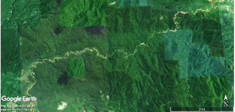
The Lagan–Pagindar Road stretches 23.1 km from the center capital to furthest sub-district of the Pakpak Bharat, the road cuts through forest areas (Figure 7).
Figure 7. Lagan-Pagindar Road by Google Earth satellite imagery
Open access to the Lagan-Pagindar Road encourages forest degradation and land conversion in the Sikulaping protected forest area, which is characterized by a reduction in the area of primary dry land forest to secondary dry land forest and shrubs on either side of the road. Increasing accessibility to forest areas can cause changes in forest land into various forms of non-forest land, such as agriculture or residential areas, which can have direct impacts in the form of damage to forest areas, indirect impacts in the form of illegal logging, exploitation of natural resources, changes in local culture, and land use/ownership conflict [35].
Table 5. Land cover in the Sumatran Orangutan habitat around Jalan Lagan-Pagindar
|
No. |
Land Cover Class |
2011 |
2022 |
||
|
Area (Ha) |
Percentage (%) |
Area (Ha) |
Percentage (%) |
||
|
1. |
Primary dryland forest |
1,759.7 |
94.9 |
1,671.0 |
90.1 |
|
2. |
Secondary dryland forest |
55.7 |
3 |
116.0 |
6.3 |
|
3. |
Plantation forest |
6,7 |
0.4 |
8.6 |
0.5 |
|
4. |
Shrubs |
13.7 |
0.7 |
40.1 |
2.2 |
|
5. |
Plantation |
- |
- |
1.0 |
0.1 |
|
6. |
Settlement |
- |
- |
2.9 |
0.2 |
|
7. |
Open land |
8.0 |
0.4 |
0.9 |
0.1 |
|
8. |
Waterbody |
- |
- |
1.4 |
0.1 |
|
9. |
Agriculture |
9.6 |
0.5 |
9.8 |
0.5 |
|
10. |
Ricefield |
0.4 |
0.0 |
1.9 |
0.1 |
|
Total |
1,853.7 |
100 |
1,853.7 |
100 |
|
Analysis of the land cover in the edge Sumatran Orangutan habitat around the Lagan-Pagindar before (2011) and after (2022) the Lagan-Pagindar Road construction is dominated by primary dry land forest. The most significant increase in land cover 2011-2022 was rice fields with an area of 1.5 Ha (350.7%), shrubs with 26.4 Ha (193.2%), and secondary dry land forest with an area of 60.3 Ha (108.4%). Meanwhile, the most significant decrease in land cover was in the open land class covering an area of 7.1 Ha (88.6%) and primary dry land forest covering an area of 88.7 Ha (5.0%) (Table 5).
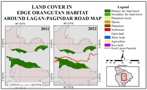
It is feared that the increase in land cover other than forest in the Sumatran Orangutan habitat will pose a threat the Sumatran Orangutan, such as changes in interactions and behavior of the Sumatran Orangutan due to habitat changes. The quality of suitable Orangutan habitat is food availability in the form of fruit, land cover conditions with interconnected canopies to facilitate movement, minimal disturbance from human activities, and gentle slopes and a certain height [36]. Land cover classes that do not have a continuous canopy will hinder the movement of Orangutans and land cover classes related to human activities increase the threat to Sumatran Orangutans. Figure 8 shows the land cover in the edge Sumatran orangutan habitat around the Lagan-Pagindar before (2011) and after (2022) road construction.
Figure 8. Map of land cover in edge Orangutan habitat around the Lagan-Pagindar Road
Figure 9. Map of Sumatera Orangutan habitat distance from road
The opening of the Lagan-Pagindar Road access provides an opportunity for activities that can damage the forest ecosystem in the forest area, especially the orangutan habitat. Distance analysis from the road was carried out to determine the distance between the road as accessibility for human activities and the Sumatran Orangutan habitat. The disturbance and pressure experienced on the habitat will likely reduce the quality of the habitat and then result in increasingly critical animal populations [37]. This explains that human presence is a threat or needs to be watched out for. From the analysis of the influence of roads on Sumatran Orangutans, it is known that the closer to the road, the higher the threat level. Figure 9 showed the distance of the Sumatran Orangutan habitat from the road.
Analysis of the distance of Sumatran Orangutan habitat from the road from 2011 to 2022 with a distance of 0 - 1000 m increasing by 5.3%, a distance of 1000-2000 m by 4.0%, a distance of 2000-3000 m by 6.2%, and a distance of 3000-4000 m by 2.0%, while distances ≥ 4000 m decreased by 3.0%. It means that there is an increase in the area of Sumatran orangutan habitat near roads. The road's proximity to the Sumatran Orangutan habitat indicates a road on the edge or in the Sumatran Orangutan habitat isolates pockets of habitat. [38] stated that the opening of roads causes habitat fragmentation, which ultimately causes the isolation of orangutan sub-populations. For example, competition in habitat cannot be avoided; food needs are not appropriately met, causing the quality of development of the species to decline and triggering local extinction and the formation of metapopulations. The distance of Sumatran Orangutan habitat from the road can be seen in Table 6.
Table 6. Distance of Sumatran Orangutan habitat from the road
|
Distance Range Value (m) |
2011 |
2022 |
||
|
Area (ha) |
Percent-age (%) |
Area (ha) |
Percent-age (%) |
|
|
0 - 1000 |
2,360.9 |
5.0 |
2,486.7 |
5.3 |
|
1000 - 2000 |
5,280.6 |
11.2 |
5,490.9 |
11.7 |
|
2000 - 3000 |
5,878.7 |
12.5 |
6,244.2 |
13.3 |
|
3000 - 4000 |
6,186.1 |
13,2 |
6,307.9 |
13.4 |
|
≥ 4000 |
27,268.6 |
58.1 |
26,444.0 |
56.3 |
|
Total |
46,974.8 |
100.0 |
46,974.8 |
100.0 |
Figure 10. Forest class landscape metrics: (a) Total core area, (b) Average patch size, (c) Number of patches and patch density, (d) Total edge area, (e) Edge density and weighted average shape index, (f) Average shape size index
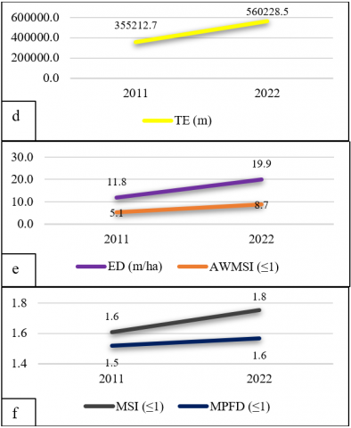
The habitat of the Sumatran Orangutan is experiencing fragmentation due to the construction of the Lagan-Pagindar Road. This fragmentation occurs by linear features cut the forest landscape in the Sumatran Orangutan habitat in the form of roads, which over time, will form a road network that may result in splitting a large habitat into several smaller habitats. The analysis of landscape metrics demonstrates this. Figure 10 shows a metric analysis graph of the Sumatran Orangutan habitat landscape around Jalan Lagan-Pagindar.
Figure 11. Classification map of orangutan habitat land cover around Jalan Lagan – Pagindar
Analysis of landscape metrics shows that there is a decrease in core area (TCA) by 6.14% and average patch size (MPS) by 37.41%. In comparison, there will be an increase in the number of patches (NumP) by 50%, patch density (PD) by 59.81%, total edge area (TE) of 57.72%, edge density (ED) of 68.10%, average shape index (MSI) of 9.06%, shape index (AWMSI) of 69, 11%, Mean Patch Fractal Dimension (MPFD) of 3.04%. The road cuts through the Sumatran Orangutan habitat (Figure 11).
The impact of roads and land clearing can have a range of detrimental effects on tropical forests and wildlife. The physical disturbance of road construction can majorly impact local soils and hydrology [39]. Concerns of landslides are raised due to the Lagan-Pagindar road's physical characteristics, which hilly forest. Open forest areas can cause edge effects such as changes in environmental conditions [40].
The Sumatran Orangutan nest discovered on the edge of Lagan–Pagindar Road. The opening of road access provides easy access for hunters to reach the Sumatran Orangutan habitat and makes it possible to carry out illegal hunting for the Sumatran Orangutan. If the effect is strong enough, the road becomes a wildlife threat that contributes to local extinctions of species.
On the other hand, ease of access for the community has led to the opening of several forest areas around roads with flat land due to the conversion of forests to other uses, such as agricultural land on Lagan-Pagindar Road. Whether or not an area is prone to encroachment is primarily determined by the level of slope and road access; the flatter the land, the higher the potential for encroachment because road access is easy to reach [41].
Disconnection of Sumatran Orangutan connectivity and interaction is one of the threats to the existence of Sumatran Orangutans. The inability of species to move between pockets of habitat causes a loss of genetic variability and diversity, which can ultimately lead to the loss of fragmented habitat, the size of the fragment will also affect the number of species and will affect the ability of the species to survive in the fragment [14]. The remaining habitat fragments are always smaller than the original habitat. Isolation of pockets of habitat (habitat patches) occurs as the landscape continues to fragment.
Research [42] of road expansion due to Rabi oil mining activities between Loango National Park and Moukalaba-Doudou National Park in the southern part of Gabon, Africa, shows that roads and hunting pressure strongly impact mammal communities. Changes in mammal community structure can broadly impact forest ecosystems through predation, herbivory, and seed dispersal changes. The intensity of hunting is not the only threat; human activity on the edge of the forest results in reduced canopy cover. Within a kilometer of a village, gorilla animals that are thought to inhabit primary and secondary forests have been spotted. Gorilla abundance has a negative correlation with local hunting pressure. Roads and hunting significantly changed mammalian communities' structure and the behavior of many species, such as monkeys, which showed a greater tendency to flee.
The impact of road opening is mitigated to reduce the environmental effects. The impact of opening roads is mitigated by assessing road impacts to reduce environmental impacts. Environmental impact assessment (EIA) reading processes in many developing nations ignore the effects of roads on land speculation, forest invasion, poaching, and secondary road expansion, favoring primarily the road route [43]. Road clearing was a significant forest loss and degradation driver during a fundamentally flawed EIA process [44]. Government policy is needed to arrange national spatial planning to pay attention to wildlife, such as creating buffer zones around road construction.
The road design strategy is that road repairs and road density should generally be minimized to maintain wildlife sensitive to disturbance and hunting; edge effects along road openings are reduced by allowing secondary plant growth to propagate and reproduce along forest boundaries, minimizing width; maintaining a relatively continuous canopy growing over the road; bridges created as animal corridors with natural vegetation are very effective for maintaining connectivity; in particular, artificial canopy bridges can provide a bridge for the movement of many arboreal species in tropical areas to connect separate pockets of habitat; and limit vehicle speeds (such as speed limits, speed bumps, warning lanes) and set up warning signs [40]. Economic development and regional integration must consider the balance of environmental preservation.
Changes in landscape structure in land cover classes of the Sumatran Orangutan habitat between 2003 to 2022 show an increase in the area of land cover classes related to human activities such as settlements, plantations, and agriculture. Human activities in the Sumatran Orangutan habitat will threaten to the lives of the Sumatran Orangutan, such as narrowing or reducing the size of the habitat, fragmentation, and even conflict between orangutans and humans. The proximity of the Sumatran Orangutan habitat to areas of human activity indicates that there are indications of human activity on the edge of the Sumatran Orangutan habitat, which is feared to pose a threat to the Orangutan.
Impact of the Lagan-Pagindar Road construction show has caused the Sumatran Orangutan habitat to become fragmented. It has triggered changes in land use and Sumatran Orangutan habitat around the Lagan-Pagindar Road. The increase in the area of Sumatran Orangutan habitat near roads indicates a road on the edge or in the Sumatran Orangutan habitat isolates pockets of habitat. Regional development can be impacted by anthropogenic processes that lead to changes in landscape structure.
Sumatran Orangutans are arboreal animals; potential mitigation efforts for road impacts include creating wildlife corridors with natural vegetation, which is very effective in maintaining connectivity; in particular, artificial canopy bridges can provide a bridge for the movement of many arboreal species in tropical regions to connect separate pockets of habitat. Planning and conducting a thorough assessment of infrastructure development is necessary to reduce the adverse effects of land use change, urbanization, and anthropogenic disturbance on the most critical habitats for endangered species. With this planning, infrastructure development is more environmentally friendly and sustainable in achieving infrastructure development while protecting biodiversity.
This work is funded by the Yayasan Orangutan Sumatera Lestari–Orangutan Information Centre, Indonesia, is an NGO working in collaboration with communities living alongside orangutan-populated areas in the Leuser Ecosystem and the Batang Toru Ecosystem. Thanks to The Equatorial Forest Tangguh Foundation (TaHuKah), an NGO sustainability of the ecosystem that indirectly facilitated the research.
[1] Wich, S.A., Riswan, Jenson, J., Refsch, J., Nellemann, C. (2011). Orangutans and The Economics of Sustainable Forest Management in Sumatra. Grid-Arendal, Norway.
[2] KSDAE, D. (2019). Strategi dan Rencana Aksis Konservasi Orangutan Indonesia 2019-2029. Jakarta, Indonesia: Kementerian Lingkungan Hidup dan Kehutanan Republik Indonesia.
[3] Haq, A.K. (2021). Peran lembaga pelestarian satwa borneo orangutan survival samboja lestari terkait perlindungan hukum terhadap satwa yang dilindungi dari perdagangan liar di Kalimantan Timur. Journal of Law (Jurnal Ilmu Hukum), 7(2): 623-635.
[4] Nater, A., Arora, N., Greminger, M.P., van Schaik, C.P., Singleton, I., Wich, S.A., Krützen, M. (2013). Marked population structure and recent migration in the critically endangered Sumatran Orangutan (Pongo abelii). Journal of Heredity, 104(1): 2-13. https://doi.org/10.1093/jhered/ess065
[5] Hayuni, W. (2017). Persepsi masyarakat terhadap kebebasan fragmentasi habitat orang Utan Sumatera (Pongo Abelii) di hutan rawa tripa sebagai penunjang mata kuliah ekologi dan masalah lingkungan. Doctoral Dissertation. UIN Ar-Raniry.
[6] Sembiring, J., Azvi, T.S. (2019). Estimation of Orangutan populations in Sibongkaras Pakpak Bharat Village Forest area. Journal of Islamic Science and Technology, 6(1): 133-145. https://doi.org/10.22373/ekw.v6i1.5549
[7] Berutu, L., Agustono, B., Solin, A., Kharina, N., Suhartono, E. (2013). Sejarah berdirinya kabupaten pakpak bharat. Universitas Sumatera Utara. https://scholar.google.com/citations?view_op=view_citation&hl=en&user=jlXZZKoAAAAJ&citation_for_view=jlXZZKoAAAAJ:d1gkVwhDpl0C, accessed on Feb. 22, 2024.
[8] Bupati Pakpak Bharat Tinjau Jalan Penghubung Lagan-Pagindar. https://www.pakpakbharatkab.go.id/v1/berita/2022-03-02/bupati-pakpak-bharat-tinjau-jalan-penghubung-lagan-pagindar, accessed on Feb. 22, 2024.
[9] Rencana Tata Ruang Wilayah Kabupaten Pakpak Bharat Tahun 2016-2036. Peraturan Daerah (PERDA) Kabupaten Pakpak Bharat Nomor 9 Tahun 2016. https://peraturan.bpk.go.id/Details/39429, accessed on Feb. 22, 2024.
[10] Azvi, T.S., Sembiring, J. (2021). Keanekaragaman Jenis Pohon di Kawasan Penyangga Hutan Lindung Sikulaping Kabupaten Pakpak Bharat, Indonesia (Tree Diversity in Bufferzone Area at Sikulaping Protected Forest, Pakpak Bharat District, Indonesia). Jurnal Pembelajaran dan Biologi Nukleus, 7(1): 235-247. https://doi.org/10.36987/jpbn.v7i1.1997
[11] Derajat, R.M., Sopariah, Y., Aprilianti, S., Taruna, A.C., Tisna, H.A.R., Ridwana, R., Sugandi, D. (2020). Land cover classification using Landsat 8 operational land imager (OLI) images in Pangandaran District. Journal of Ocean Geography, 3(1): 1-10. https://doi.org/10.33059/jsg.v3i1.1985
[12] Wiggers, M., Nuarsa, I., Putra, I. (2020). Monitoring changes in coastal land use in Batu Layar District, West Lombok Regency in 2002 and 2019. Journal of Marine Research and Technology, 3(2): 68-74. https://doi.org/10.24843/jmrt.2020.v03.i02.p02
[13] Muhammed, A., Elias, E. (2021). Class and landscape level habitat fragmentation analysis in the Bale Mountains National Park, Southeastern Ethiopia. Heliyon, 7(7): 1-12. https://doi.org/10.21203/rs.3.rs-125115/v2
[14] Gunawan, H., Prasetyo, L.B. (2013). Forest fragmentation: The theory underlying forest spatial planning towards sustainable development. Research and Development Center for Conservation and Rehabilitation, Bogor.
[15] Flowers, B., Huang, K.T., Aldana, G.O. (2020). Analysis of the habitat fragmentation of ecosystems in Belize using landscape metrics. Sustainability, 12(7): 1-14. https://doi.org/10.3390/su12073024
[16] Mezgebu, A., Workineh, G. (2017). Changes and drivers of Afro-Alpine Forest ecosystem: Future trajectories and management strategies in Bale eco-region, Ethiopia. Ecological Processes, 6(1): 1-13. https://doi.org/10.1186/s13717-017-0108-2
[17] Population and habitat viability assessment (PHVA) orangutan 2016. https://www.forina.org/phva-2016, accessed on Feb. 22, 2024.
[18] Wich, S.A., Singleton, I., Nowak, M.G., Utami, A.S.S., Nisam, G., Arif, S.M., Kühl, H.S. (2016). Land-cover changes predict steep declines for the Sumatran Orangutan (Pongo abelii). Science Advances, 2(3):1-8. https://doi.org/10.1126/sciadv.1500789
[19] Atmoko, S., Sihite, J., Nuzuar., Singleton, I. (2010). Perkembangan terbaru populasi dan sebaran orangutan sumatera (Pongo abelii). In Prosiding Workshop Konservasi Orangutan Internasional, Bali, Indonesia, pp. 105-110. https://issuu.com/forina/docs/prosiding_iwoc_bahasa
[20] Badan Pusat Statistik. (2019). Statistik Daerah Kabupaten Pakpak Bharat 2019. Badan Pusat Statistik Pakpak Bharat, Salak. https://pakpakbharatkab.bps.go.id/publication/2019/12/31/e1b58d77b49ac09734be21fb/statistik-daerah-kabupaten-pakpak-bharat-2019.html
[21] Sulistiyono, N., Ginting, B.S.P., Patana, P., Susilowati, A. (2019). Land cover change and deforestation characteristics in the management section of national park (MNSP) VI Besitang, Gunung Leuser National Park. Journal of Sylva Indonesiana, 2(2): 91-100. https://doi.org/10.32734/jsi.v2i2.1120
[22] Putra, R.H. (2014). Kajian habitat dan populasi badak sumatera (Dicerorhinus sumatrensis Fischer 1814) di Kapi, Kawasan Ekosistem Leuser Provinsi Aceh. Master dissertation. IPB University.
[23] Sulistyadi, E., Kartono, A.P., Maryanto, I. (2013). Pergerakan lutung jawa Trachypithecus auratus (E. Geoffroy 1812) pada fragmen habitat terisolasi di Taman Wisata Alam Gunung Pancar (TWAGP) Bogor. Berita Biologi, 12(3): 383-395. https://doi.org/10.14203/beritabiologi.v12i3.647
[24] Prasetyo, L.B. (2017). Lilik Budi. Pendekatan ekologi lanskap untuk konservasi biodiversitas (Landscape ecology approach to biodiversity conservation). Faculty of Forestry, Bogor Agricultural Institute, Bogor.
[25] Liu, Z., He, C., Wu, J. (2016). The relationship between habitat loss and fragmentation during urbanization: An empirical evaluation from 16 world cities. PLoS One, 11(4): 1-9. https://doi.org/10.1371/journal.pone.0154613
[26] Vicayana, D.P. (2018). Analisis Pola spasial deforestasi di kota Palopo dan kabupaten Luwu timur (Analysis of spatial patterns of deforestation in Palopo City and East Luwu Regency). Hasanuddin University.
[27] Oertli, B., Joye, D.A., Castella, E., Juge, R., Cambin, D., Lachavanne, J.B. (2002). Does size matter? The relationship between pond area and biodiversity. Biological Conservation, 104(1): 59-70. https://doi.org/10.1016/s0006-3207(01)00154-9
[28] Gunawan, H., Prasetyo, L.B., Mardiastuti, A., Kartono, A.P. (2010). Dryland natural forest fragmentation in Central Java Province. Journal of Forest Research and Nature Conservation, 7(1): 75-91. https://doi.org/10.20886/jphka.2010.7.1.75-91
[29] McGarigal, K., Cushman, S.A., Ene, E. (2012). FRAGSTATS v4: Spatial pattern analysis program for categorical and continuous maps. University of Massachusetts, Amherst.
[30] Daye, D.D., Healey, J.R. (2015). Impacts of land-use change on sacred forests at the landscape scale. Global Ecology and Conservation, 3(1): 349-358. https://doi.org/10.1016/j.gecco.2014.12.009
[31] McGarigal, K., Marks, B.J. (1995). Spatial pattern analysis program for quantifying landscape structure. US Department of Agriculture, Forest Service, Pacific Northwest Research Station.
[32] Paudel, S., Yuan, F. (2012). Assessing landscape changes and dynamics using patch analysis and GIS modeling. International Journal of Applied Earth Observation and Geoinformation, 16(1): 66-76. https://doi.org/10.1016/j.jag.2011.12.003
[33] Smith, G., Smith, M., Singleton, I., Linkie, M. (2011). Apes in space: Saving an imperilled orangutan population in Sumatra. PLoS One, 6(2): 1-8. https://doi.org/10.1371/journal.pone.0017210
[34] Morrison, M.L., Marcot, B.G., Mannan, R.W. (2012). Wildlife-Habitat Relationships: Concepts and Applications. ISLAND Press.
[35] Susetyo, B. (2013). Pengaruh pembangunan jalan terhadap perubahan penggunaan lahan pada kawasan hutan konservasi pulau kecil di taman Buru Pulau Rempang, Batam (The effect of road construction on land use changes in the small island conservation forest area in Buru Park, Rempang Island, Batam). Doctoral Dissertation. Gadjah Mada University, Yogyakarta.
[36] Prayogo, H., Thohari, A.M., Solihin, D.D., Prasetyo, L.B., ugardjito. (2014). Pendugaan kesesuaian habitat orangutan kalimantan (Pongo pygmaeus pygmaeus) dan karakteristik genetiknya di Kabupaten Kapuas Hulu Kalimantan Barat (Estimation of habitat suitability of the Bornean Orangutan (Pongo pygmaeus pygmaeus) and its genetic characteristics in Kapuas Hulu Regency, West Kalimantan). Dissertations, IPB University.
[37] Dewi, R.S., Mulyani, Y., Santosa, Y. (2007). Diversity of Bird Species in Several Habitat Types in Mount Ciremai National Park. Institut Pertanian Bogor, Bogor.
[38] Siregar, D.I., Zaitunah, A., Patana, P. (2015). Pemetaan daerah rawan konflik Orangutan Sumatera (Pongo abelii) dengan manusia di desa sekitar cagar alam dolok sibual-buali. Peronema Forestry Science Journal, 4(1): 120-133.
[39] Olander, L.P., Scatena, F.N., Silver, W.L. (1998). Impacts of disturbance initiated by road construction in a subtropical cloud forest in the Luquillo experimental forest, Puerto Rico. Forest Ecology and Management, 109(1): 33-49. https://doi.org/10.1016/s0378-1127(98)00261-8
[40] Laurance, W.F., Goosem, M., Laurance, S.G.W. (2009). Impacts of roads and linear clearings on tropical forests. Trends in Ecology & Evolution, 24(12): 659-669. https://doi.org/10.1016/j.tree.2009.06.009
[41] Mangil, W.R.S., Akhbar, A., Muis, H., Arianingsih, I., Misrah, M. (2020). Analisis spasial tingkat sebaran perambahan kawasan hutan pendidikan Universitas Tadulako (Spatial analysis of the level of distribution of encroachment in the Tadulako University educational forest area). Journal of Warta Rimba, 8(2): 114-121.
[42] Laurance, W.F., Croes, B.M., Tchignoumba, L., Lahm, S.A., Alonso, A., Lee, M.E., Campbell, P., Ondzeano, C. (2006). Impacts of roads and hunting on central African rainforest mammals. Conservation Biology, 20(4): 1251-1261. https://doi.org/10.1111/j.1523-1739.2006.00420.x
[43] Reid, J., de Souza, W.C. (2005). Infrastructure and conservation policy in Brazil, Conservation Biology, 19(1): 740-746. https://doi.org/10.1111/j.1523-1739.2005.00699.x
[44] Laurance, S.G. (2006). Rainforest roads and the future of forest-dependent wildlife: A case study of understory birds. Emerging Threats to Tropical Forests, 253-267.