Qusay Nafea Jaafar*![]() | Khamis Naba Sayl
| Khamis Naba Sayl![]() | Ammar Hatem Kamel
| Ammar Hatem Kamel![]()
© 2023 IIETA. This article is published by IIETA and is licensed under the CC BY 4.0 license (http://creativecommons.org/licenses/by/4.0/).
OPEN ACCESS
Sedimentation and reduced water flow can lead to the dispersion of a river's course. In this investigation, the HEC-RAS model, along with hydrological and engineering data, was employed to construct a one-dimensional steady-state simulation to inform cross-sectional modifications. Two distinct scenarios were examined: the initial scenario involved simplistic lateral adjustments to the river banks and bed, designed to accommodate a maximum discharge with a 10-year return period (1133 m³/s). These modifications were found to have a negligible impact on the river's linearity. In contrast, the second scenario proposed the implementation of two trapezoidal cross-sections: one for the 10-year return period discharge, and another for a 50-year return period discharge (2005 m³/s). The latter amendments notably altered the river's course straightness, yielding a substantial increase in hydraulic capacity and velocity when compared to the former. Based on the outcomes, the study advocates for the adoption of the second scenario with uniform cross-section dimensions throughout the target area. This approach is recommended on the grounds of its superior enhancement of the river's hydraulic performance.
river training, HEC-RAS, water, sediment, sediment transport, river morphology, flood management
The Euphrates River, a critical waterway for the region, has experienced significant hydrological alterations due to the compounding effects of climate change and upstream water management practices. Dams constructed within Turkish and Syrian territories have notably diminished the river's inflow, while policies enacted by these upstream nations have further exacerbated the issue. Consequently, the river has witnessed increased sedimentation rates, the emergence of central islands, and alterations in its course—predominantly due to asymmetric sedimentation and erosion dynamics. These physical changes have impaired the river's water conveyance efficiency, potentially threatening adjacent infrastructure, residential areas, and agricultural lands with material losses and increased flood risk. Given the significant material losses attributed to these alterations, it has become imperative to identify and implement solutions aimed at preventing or mitigating such changes.
River training, a strategy aimed at stabilizing and managing river channels, has been recognized as an essential measure to mitigate these effects within the city of Ramadi—a locale of significant touristic and economic importance. This intervention typically involves the realignment of channels, sediment management to augment capacity, and modifications to facilitate navigation [1]. The efficacy of river training stems from its capacity to maintain navigable depths and prevent the detrimental impacts of both land loss due to course changes and flooding on human settlements and agricultural activities [2, 3].
This study leverages the Hydrologic Engineering Centers River Analysis System (HEC-RAS) model, a tool that has been widely utilized across various domains of river management. The first domain encompasses sediment removal, a vital process to ensure the maintenance of flow rates and the operational integrity of hydraulic structures, as sediment accumulation can impede water movement and necessitate costly remedial measures [4-10]. The second domain focuses on flood risk reduction, with extensive research dedicated to delineating flood extents and water levels [11-17]. The third domain addresses the challenges of navigation, particularly the issue of reduced watercourse depths that obstruct vessel transit [18-22]. Lastly, the fourth domain involves extensive river training to counteract lateral migration and channel broadening resultant from recurrent flooding events [23-29].
Despite the breadth of research in these domains, there remains a paucity of studies that elucidate the process of modifying river cross-sections and evaluating their impact on water levels and course stability. Addressing this knowledge gap, the current investigation seeks to design and evaluate various river cross-section modifications based on hydrological return periods of 10 and 50 years, alongside a simplistic modification approach, to ascertain the most effective design for sustaining the river's flow and preventing course dispersion.
The objective of this study is to identify an optimal river cross-section that stabilizes the Euphrates River's course and is compatible with the full range of discharge levels experienced by the river.
2.1 Study area
The Euphrates River is considered one of the important rivers in the Arab world, as this river originates from Turkey and flows in the Syrian lands and enters Iraq in the city of Al-Qaim a reaches the Shatt Al-Arab and meets the Tigris River in Qurna region [1, 30, 31].
The study area is located on the Euphrates River within Anbar Governorate, western Iraq as shown in Figure 1. The Euphrates River enters Anbar province in the city of Al-Qaim. The study area starts in the city of Ramadi from Ramadi Dam at geographic coordinates (33°26'25.931'' N )(43°16'8.0113'' E) to Imam Ali Bridge at geographic coordinates (33°27'54.3933'' N) (43°20'33.4234'' E). The length of the study area is about 6 km. This area is a vital area and contains many projects on the banks of the river. Also the region suffers from a change in the course of the river, the dispersion of water, the abundance of tailings, and the emergence of central islands. No river training operations have been carried out in this region, so it is necessary to conduct a study and conduct river training work in this field to maintain the facilities on the banks of the river as well as reducing the amount of water dispersed and wasted and knowing the impact of these works when the water level rises and decreases is also important. The area is also considered a tourist area.
Figure 1. The study area
2.2 Data and material
The data required to carry out the hydraulic modeling process is shown in the Table 1. The data was obtained from the Water Resources Directorate in Anbar, which is considered the only official body responsible for managing water resources in the governorate, so it is considered highly reliable.
Table 1. Data collected by the researchers
|
|
Data Type |
Date |
Reference |
|
1 |
Discharge data |
1989-2023 |
Directorate of Water Resources in Anbar |
|
2 |
Water Level data |
2018-2023 |
Directorate of Water Resources in Anbar |
|
3 |
River Cross section data |
4-8-2022 |
Obtained by the researcher |
|
4 |
Calibration data |
20-9-2022 |
Obtained by the researcher |
Also, the devices (depth measuring device, level station, global positioning system (GPS), ruler, and level measuring device) were used in cross-section surveys.
2.3 Methodology
River training refers to the deliberate modification and management of rivers to control their flow, prevent erosion, and protect adjacent areas from flooding. This process involves the use of various engineering techniques and structures to stabilize river channels and improve their navigability. This work relied on a number of steps as shown in Figure 2.
1. Data collection and analysis, including cross-section data, discharges, levels, cross-section coordinates, boundary conditions, and Manning coefficient calculation.
2. Data entry, model development and operation in a stable condition.
3. Making different scenarios and choosing the best they include:
(1) Running the Euphrates River model in the current situation with cladding on the sides to bear the discharge which has a return period of 10 years which is (1133 m3⁄s).
(2) Running the model after modifying the cross-sections in the form of a trapezoid manner to bear a discharge that has a return period of 10 years (1133 m3⁄s) and the model is run after designing the same shape but with a larger size to bear the discharge that has a return period of 50 years (2005 m3⁄s).
2.3.1 Data collection and scan cross sections
The required data was obtained from field surveys, previous research reports, and administrative agencies. Table 1 presented the most important data and information required for the analysis. Hydrological data, which includes river discharges and water levels at the rear of Ramadi Dam, was obtained from the Directorate of Water Resources in Anbar Province. A field survey of the river sections and part of the floodplain areas were conducted by the researchers with the assistance of a specialized survey engineer. The Total Station was used to determine the straightness of the cross-section perpendicular to the course of the river. The level and coordinates of the point on the river bank were determined in the first section, then the researchers went down with the surveyor to the river by boat, and three points along the cross-section were identified, also the water level and the bottom at each point where the water depth was measured with a device (depth sensor). Then the level and coordinates of the second point on the other bank of the river were calculated. Thus, we have five known relative and coordinate points, two of which are on the right and left banks of the river, and three are upstream. In the same way the rest of the cross-sections of the river were surveyed. The survey produced 27 cross-sections along the river in the study area, all of which were surveyed during one day. The AutoCAD program was used for the purpose of fixing the survey work, coordinates, and levels on the agenda.
Figure 2. The work steps through which the model was run for several scenarios
2.3.2 Overview of HEC-RAS
HEC-RAS is a hydraulic model designed by the Hydraulic Engineering Center of the American Corporation for River Flow Modeling [32]. It is a well-established and well-tested model in the world and is sometimes used as a benchmark against the performance of other hydrodynamic model simulation software [31]. HEC-RAS allows users to estimate the water surface profile along a river in a steady and unsteady river hydraulic calculation including sediment transport modeling. The equation of energy and momentum is equivalent (Eqs. (1) and (2)). It is used to derive the 1D Saint-Venant equation in solving water surface profile simulations for steady and unsteady state flows within HEC-RAS using a different finite implicit method [33]. This model was chosen instead of many hydraulic models due to the presence of experienced staff working on the model who were assisted in operating the model. The model was also used in many studies on the Euphrates River in the same governorate and it gave excellent results, which increased the percentage of choice of the model.
$\frac{\delta A}{\delta t}+\frac{\delta S}{\delta t}+\frac{\delta Q}{\delta x}-q=0$ (1)
$\frac{\delta Q}{\delta t}+\frac{\delta(V Q)}{\delta x}+g A\left(\frac{\delta z}{\delta x}+S_f\right)=0$ (2)
where, A is the cross-sectional area, t is the time, S is the ineffective flow area, Q is the discharge, q is the inflow per unit area, x is the distance along the channel, V is the velocity, z is the elevation, Sf is the friction slope and g is the gravitational acceleration.
2.3.3 Input data into the HEC-RAS model
One-dimensional hydraulic modeling was used in the steady state where the geometric data was entered, which includes the longitudinal river section, which was drawn with the help of Ras Mapper available within the HEC-RAS model, and then the coordinates of the cross sections of the river were entered and were projected on the longitudinal river section to be distributed along the river, and thus the geometric data entry was completed. After completing the geometric data, the boundary conditions were entered, where the discharges were entered in U/S and the normal depth in D/S. After that, the model calibration begins.
2.3.4 Manning's roughness
Manning's roughness often referred to as Manning's n or Manning's coefficient, is a measure used to quantify the roughness or resistance to flow in open channels. It is named after the Irish engineer Robert Manning, who developed the Manning's equation for uniform open channel flow.
Manning's roughness coefficient (n) represents the roughness characteristics of the channel bed and banks. It is a dimensionless value that is used in the Manning's equation to calculate the velocity of flow in an open channel. The Manning's equation Eq. (3) is as follows:
$V=\frac{1}{n} R^{\frac{2}{3}} S^{\frac{1}{2}}$ (3)
where,
V is the velocity of flow in the channel,
n is Manning's roughness coefficient,
R is the hydraulic radius (ratio of cross-sectional area to wetted perimeter),
S is the slope of the channel.
The Manning's roughness coefficient (n) varies depending on the type of surface or material in the channel. It represents the resistance to flow caused by factors such as vegetation, channel irregularities, sediment, and other obstructions. Different values of Manning's n are assigned to various types of channels, such as concrete-lined channels, grass channels, natural streams, etc.
Engineers and hydrologists use Manning roughness coefficients to estimate flow velocities, water depths, and other hydraulic parameters in open channel flow calculations. The appropriate Manning n value for a given channel depends on the channel characteristics, and is often determined from field measurements or reference tables that provide typical values for different types of channels.
The Manning coefficient was chosen for the stone used in the cladding, which is 0.027, according to what is found in the tables devoted to Manning values in [34] and according to the specifications available at the Ministry of Water Resources. This value was chosen for Manning.
2.3.5 Model calibration
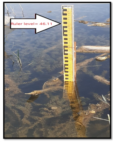
Calibration of the HEC-RAS model requires the availability of hydrological data (river water levels and river discharges) that are calculated realistically and accurately by the researchers. Therefore, the researchers began to install two rulers to measure water levels, the first ruler in the middle of the distance for the study area, and the second ruler was installed at the end of the distance for the study area, The zero level of the two rulers was calculated in order to facilitate the process of recording river levels daily. The river levels were recorded in both regions where the two rulers were installed for about two months.
Figure 3. Ruler for measuring water levels in the middle of the distance to the study area
The Figures 3 and 4 show how to install the two rulers. Figure 3 represents the ruler that was installed in the middle of the study area, and Figure 4 represents the ruler that was installed at the end of the study area, where these two rulers were used to measure water levels for a month in order to take advantage of these data in the process of calibrating the model accurately.
Figure 4. Ruler for measuring water levels at the end of the distance to the study area
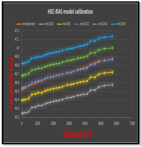
The HEC-RAS model was calibrated by running a discharge of (280 m3/s), which is the river discharge on the day the cross sections were surveyed, where the actual water levels are available for each of the river sections also along the study area. The boundary conditions were used in the D/S, which is the normal depth.
To calibrate the model, n is changed to a match which is obtained between the actual measured level and the calculated level from the model, where n = 0.032 was chosen, which is the parameter that is matched with a high percentage, as shown in Figure 5.
Figure 5. The calibration process of the HEC RAS model
2.3.6 HEC-RAS run
The HEC-RAS model was run after the model had been calibrated accurately, as the calibration resulted in the Manning coefficient n = 0.032, which is the coefficient that provides an exact match for the measured and calculated levels, and thus the model is ready to run any other discharge and to know the extent of the impact of this discharge, its level and all the details related to it. However, after modifying the sections and cladding the sides, a different manning coefficient is used according to the type of material used in the cladding. The value of Manning's coefficient is 0.027, according to the specifications known in the Ministry of Water Resources. The boundary conditions are then introduced, and then the modification of the cross sections in the first scenario begins in a simple manner. After that, the model is run and several attempts are made to modify the cross sections to obtain the appropriate design to withstand the expected discharge. Work continues on modifying the cross sections for the second scenario in the same way to obtain the results required to withstand the expected discharges.
By reviewing many studies conducted on the Euphrates River in Anbar Governorate, it was found that most studies indicate that the river has been affected by climate change, as well as the decrease in water entering the river and the increase in sediments which reduces the river’s capacity to withstand high discharges, which led to the dispersion of the river’s course and an increase in losses, and thus It has become difficult to benefit from the amount of water passing through the river [35]. Here the importance of the study appears in unifying the river’s course, increasing the river’s capacity, and also stabilizing the river’s course.
The findings of this study are presented and analyzed by performing several modifications to the river section in the HEC-RAS model. The analyses are made to test modifications that can be made to the river section on the basis of the maximum discharge with return periods (10 and 50) years As shown in Table 2.
Table 2. The status of scenarios with expected discharges during certain return periods
|
Scenario |
Discharge (m3/s) |
Return Period (year) |
|
The natural state |
320 (average) |
|
|
first scenario |
1133 (max) |
10 |
|
second scenario (1) |
1133 (max) |
10 |
|
second scenario (2) |
2005 (max) |
50 |
In the current study, two scenarios were tested for the process of improving or modifying the course of the river. In each scenario, the maximum recorded discharges of the river are taken into account with the return periods that referred to (10 and 50) years. The above scenarios were compared with the current natural state of the river, without modification to find out the effect of each scenario on the hydraulic efficiency of the river section. These return periods were adopted because most studies of the Euphrates River and the United Nations reports regarding the sitution of water resources in Iraq indicate that the recurrence of periods of drought and humidity fluctuates greatly due to the nature of arid and semi-arid regions as in Iraq. Therefore, a relatively medium and long return period was tested to find out the possible river discharges.
The natural state of the river reach (without modification) with average discharge (320 m3/s) is shown in Figure 6 it is based on the available data from the Iraqi Ministry of Water Resources. These data were observed during the period (1985-2022) when the Haditha dam was achieved in 1985 and was considered the main control structure for the flow of the Euphrates River. The flow simulation with HEC-RAS indicates that the overflow will occur at some stations along the reach as shown in Figure 6.
Figure 6. The longitudinal section of the river (HEC RAS model with a discharge of (320 m3/s)
In the first scenario, a slight modification will be made to the cross-sections by adjusting the slope of the sides of the river so that they are regular. The river bed will also be modified through dredging operations to remove sand islands and weeds that impede the movement of the water, which increases the river’s capacity for the expected discharges. These modifications will be made without manipulating the width of the cross-section significantly, meaning that the cross sections are not uniform in dimensions, but will be different.
Figure 7. The longitudinal profile (first scenario, HEC-RAS)
In this scenario, the maximum discharge for the 10-year return period is (1133 m3/s), and the river sides are slightly modified using a 1/3 side slope. The results showed that flooding or inundation occurred at many stations located along the river course, as shown in Figure 7. The river condition of the discharge with a return period of 50 years (2005 m3/s) is higher than the discharge with a return period of 10 years (1133 m3/s) which means the flood definitely occurred. Therefore, discharge (200 m3/s) was not evaluated in the current scenario.
Figure 8. The cross-section designed to accommodate a maximum discharge with return period of 10 years
Figure 9. The cross-section designed to accommodate a maximum discharge with return period of 50 years
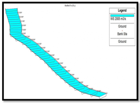
Figure 10. The longitudinal profile of the river (scenario 2, HEC-RAS)
In the second scenario, the ideal section is designed to be applied to all sections along the riverbed. Figure 8 shows the section that was designed to withstand the maximum discharge with a return period of 10 years or (1133 m3/s) without any overflow on the banks of the river. As for the second design, it was designed to withstand a discharge with a return period of 50 years or (2005 m3/s), the optimization must be achieved for the cross-section of the river as shown in Figure 9, where the slope of the sides 1/3 was used for all sections.
Based on analyses with the HEC-RAS model, the cross-section of the river can be designed with certain dimensions (bottom width = 237 m, top width = 285 m, depth = 9 m, sides slope = 1/3) to accommodate all the discharges within 50 years of return periods. Figure 10 shows the longitudinal profile of the river after making adjustments to the transverse sections of the river. The maximum discharges for each scenario with return periods will be shown in Table 2.
These designs were made on the basis of an analytical study of periods of return to the maximum discharges passing through the river for a period of 10-50 years. Amendments were also made to the main channel of the river so that the floodplain remained available in the event that the assumption was not met and something that was not expected occurred, i.e. the occurrence of a wave higher than the wave on which the river was designed, and thus the surplus will go to the floodplain, but the possibility of this happening is very weak.
In this research, two scenarios were made for the purpose of increasing the capacity of the Euphrates River in the study area and stabilizing the course of the river.
Concerning the first scenario, a slight modification was made to the cross-section without significantly changing the dimensions, and thus the shape of the longitudinal section of the river will remain irregular due to the presence of very wide and narrow cross-sections. In this scenario, the river will be able to accommodate the maximum discharge that has a return period of 10 years, which is (1133 m3/s).
As for the second scenario, two designs were made that have the same shape (trapezoid), but they differ in dimensions, and all cross-sections along the riverbed will be unified in the same shape, so the river will become more regular for the purpose of accommodating the maximum discharge, which has a return period of 10 years. It is (1133 m3/s) in relation to the first small design. As for the second design, which is larger in size, it accommodates the maximum discharge which has a return period of 50 years, which is (2005 m3/s).
The researchers concluded by analyzing the data in the HEC- RAS model that training on the river affects the hydraulic properties of the river cross-section.
The researchers recommend working with the design mentioned in the second scenario, which is a trapezoidal-shaped design to accommodate the maximum discharge with a return period of 50 years (2005 m3⁄s) because this design has a greater absorptive capacity than the first scenario and is considered more regular than the first scenario is because all its cross-sections are uniform in dimensions, which works to stabilize the river’s course. Therefore, this design is considered the best in terms of saving space, and this is very appropriate. The researchers also recommend conducting a feasibility study for the project and knowing the financial costs required to implement this design, taking into account the effects environmental and social, because this design is large compared to some cross-sections in the natural state, which leads to cutting off some lands adjacent to the river and may lead to the demolition of some residential homes for the purpose of implementing the project. Therefore, a complete study must be conducted on the amount of damage resulting from the implementation of the project.
Regarding climate changes, they were taken into consideration through the river’s discharge for a return period of 50 years, which corresponds to a discharge of 2005 m3⁄s, which was measured in the year 2020. Note that the Ministry of Water Resources indicates that the impact of climate changes on the Euphrates River Basin appeared clearly after the year 2000. As for the land use during the next 50 years, it was taken into consideration through the urban planning of the municipality of the city of Ramadi. What affects the application of the model is the reach of the Euphrates River within the city and the discharge capacity for the channel of the river. Therefore, the scenarios that were studied and the conclusions that were reached in this study took into account any possible changes to the climate or land use.
The authors would like to acknowledge their gratitude and Appreciation to the data source Ministry of water resources (MOWR), Iraq.
[1] AL-Zaidy, H.S.A., AL-Thamiry, H.A.K. (2020). Prediction capacity of Euphrates River at Assamawa City. Journal of Engineering, 26(4): 111-122. https://doi.org/10.31026/j.eng.2020.04.08
[2] Mosselman, E. (2020). Studies on river training. Water, 12(11): 3100. https://doi.org/10.3390/w12113100
[3] Wang, Z.Y., Tian, S.M., Yi, Y.J., Yu, G.A. (2007). Principles of river training and management. International Journal of Sediment Research, 22(4): 247-262.
[4] Jabar, B.S., Sayl, K.N., Rashid, R.S. (2023). Approaches to modeling soil erosion caused by water: A review. In AIP Conference Proceedings, 2775(1): 040001. https://doi.org/10.1063/5.0140870
[5] Khassaf, S.I., Ressen, S.M. (2014). Estimation the quantity of sediment transport upstream of Al-Hafar regulator using different formulas. 5(7): 456-466.
[6] Maatooq, J., Omran, H., Aliwe, H. (2016). Empirical formula for estimation the sediment load in Shat AL-Gharaf River. Basrah Journal for Engineering Science, 16(1): 38-41. https://doi.org/10.33971/bjes.16.1.7
[7] Mohammad, M. E., Al-Ansari, N., Issa, I.E., Knutsson, S. (2016). Sediment in Mosul Dam reservoir using the HEC-RAS model. Lakes and Reservoirs: Research and Management, 21(3): 235-244. https://doi.org/10.1111/lre.12142
[8] Assaf, A.T., Sayl, K.N., Adham, A. (1973). surface water detection method for water resources management. Journal of Physics: Conference Series, 1973: 012149. https://doi.org/10.1088/1742-6596/1973/1/012149
[9] Kayyun, T.S., Dagher, D.H. (2018). 2D-Unsteady flow within a reach in Tigris River. International Journal of Scientific & Engineering Research, 9(5): 2246-2251. https://doi.org/10.5923/j.ijhe.20180702.02
[10] Mustafa, A.S., Sulaiman, S.O., Al_Alwani, K.M. (2017). Application of HEC-RAS model to predict sediment transport for Euphrates River from Haditha to Heet 2016. Al-Nahrain Journal for Engineering Sciences, 20(3): 570-577.
[11] Logah, F.Y., Amisigo, A.B., Obuobie, E., Kankam-Yeboah, K. (2017). Floodplain hydrodynamic modelling of the Lower Volta River in Ghana. Journal of Hydrology: Regional Studies, 14: 1-9. https://doi.org/10.1016/j.ejrh.2017.09.002
[12] Adhikari, K. (2015). Modelling and simulation of floods in Barsa River near Pasakha. In Proceedings of the Conference on ‘Climate Change, Environment and Development in Bhutan,’ Thimphu, Bhutan, pp. 79-84.
[13] Yakti, B.P., Adityawan, M.B., Farid, M., Suryadi, Y., Nugroho, J., Hadihardaja, I.K. (2018). 2D modeling of flood propagation due to the failure of Way Ela Natural Dam. In the Third International Conference on Sustainable Infrastructure and Built Environment, 147: 1-5. https://doi.org/10.1051/matecconf/201814703009
[14] Al-Fahdawi, S.A. (2009). Numerical modeling of flood wave behavior with meandering effects (Euphrates River, Haditha-Hit). University of Technology, Builiding and Construction Engineering Department.
[15] Patel, S.B., Mehta, D.J., Yadav, S.M. (2018). One dimensional hydrodynamic flood modeling for Ambica River, South Gujarat. Journal of Emerging Technologies and Innovative Research, 5(4): 595-601.
[16] Skublics, D., Blöschl, G., Rutschmann, P. (2016). Effect of river training on flood retention of the Bavarian Danube. Journal of Hydrology and Hydromechanics, 64(4): 349-356. https://doi.org/10.1515/johh-2016-0035
[17] Zainalfikry, M.K., Ab Ghani, A., Zakaria, N.A., Chan, N.W. (2020). HEC-RAS one-dimensional hydrodynamic modelling for recent major flood events in Pahang River. Lecture Notes in Civil Engineering, 53: 1099-1115. https://doi.org/10.1007/978-3-030-32816-0_83
[18] Gilja, G., Kuspilić, N., Golubović, N. (2019). Impact of river training works on the Drava River flow regime. In 16th International Symposium Water Management & Hydraulic Engineering WMHE, pp. 89-99.
[19] Fošumpaur, P., Horský, M., Kašpar, T. (2021). Historical river training works on the lower Elbe. IOP Conference Series: Materials Science and Engineering, 1203: 022015. https://doi.org/10.1088/1757-899X/1203/2/022015
[20] Havinga, H., Taal, M., Smedes, R., Klaassen, G.J., Douben, N., Sloff, C.J. (2006). Recent training of the lower Rhine River to increase inland water transport potentials: A mix of permanent and recurrent measures. River Flow 2006, pp. 31-50.
[21] ElGamal, T., ElFetyany, M., ElKassar, G. (2019). Effect of irrigation network rehabilitation on water management-case study: Tanta Navigation canal – Egypt. Alexandria Engineering Journal, 58(4): 1215-1227. https://doi.org/10.1016/j.aej.2019.10.005
[22] Mohammed, O.A., Sayl, K.N. (2021). A GIS-based multicriteria decision for groundwater potential zone in the west desert of Iraq. IOP Conference Series: Earth and Environmental Science, 856: 012049. https://doi.org/10.1088/1755-1315/856/1/012049
[23] Azzubaidi, R.Z. (2020). Current and modified flood discharge capacity of a reach of Tigris River between Kut and Amarah barrages. Journal of Engineering, 26(2): 129-143.
[24] Ali, A.A., Al-Ansari, N.A., Knutsson, S. (2012). Morphology of Tigris River within Baghdad city. Hydrology and Earth System Sciences, 16(10): 3783-3790. https://doi.org/10.5194/hess-16-3783-2012
[25] Al Khafaji, M.S. (2008). Evaluating the hydraulic performance of Al Msharah River. Engineering & Technology, 26(3): 1-13. http://dx.doi.org/10.30684/etj.26.3.5
[26] Kidová, A., Radecki-Pawlik, A., Rusnák, M., Plesiński, K. (2021). Hydromorphological evaluation of the river training impact on a multi-thread river system (Belá River, Carpathians, Slovakia). Scientific Reports, 11: 6289.
[27] Nama, A.H. (2015). Distribution of shear stress in the meanders of Tigris River within Baghdad city. Al-Nahrain Journal for Engineering Sciences, 18(1): 26-40.
[28] Khudair, M.Y., Kamel, A.H., Sulaiman, S.O., Al-Ansari, N. (2022). Groundwater quality and sustainability evaluation for irrigation purposes: A case study in an Arid region, Iraq. International Journal of Sustainable Development and Planning, 17(2): 413-419.
[29] Mohammed, O.A., Sayl, K.N. (2020). Determination of groundwater potential zone in arid and semi-arid regions: A review. In 2020 13th International Conference on Developments in eSystems Engineering (DeSE), Liverpool, United Kingdom, pp. 76-81. https://doi.org/10.1109/DeSE51703.2020.9450782
[30] Sameer, Y.M., Abed, A.N., Sayl, K.N (2021) Highway route selection using GIS and analytical hierarchy process case study Ramadi Heet rural highway. Journal of Physics: Conference Series, 1973: 012060. 10.1088/1742-6596/1973/1/012060
[31] Sameer, Y.M., Abed, A.N., Sayl, K.N (2023) Geomatics based approach for highway route selection. Applied Geomatics, 15: 161-176. https://doi.org/10.1007/s12518-023-00495-x
[32] Brunner, G.W. (2016). HEC-RAS River Analysis System: Hydraulic Reference Manual, Version 5.0. US Army Corps of Engineers–Hydrologic Engineering Center.
[33] Zellou, B., Rahali, H. (2016) Assessment of reduced-complexity landscape evolution model suitability to adequately simulate flood events in complex flow conditions. Natural Hazards, 86: 1-29.
[34] Chow, V.T. (1959). Open Channel Hydraulics. McGraw-Hill, New York. https://www.scirp.org/reference/referencespapers?referenceid=1929585.
[35] Jaafar, Q.N., Sayl, K.N., Kamel, A.H. (2023). Numerical modelling of river training work: A review. IOP Conference Series: Earth and Environmental Science, 1222: 012010. https://doi.org/10.1088/1755-1315/1222/1/012010