Alsharifa Hind Mohammad*![]() | Marwan Ghanem
| Marwan Ghanem![]() | África de la Hera Portillo
| África de la Hera Portillo![]() | Nour-Eddine Laftouhi
| Nour-Eddine Laftouhi![]()
© 2023 IIETA. This article is published by IIETA and is licensed under the CC BY 4.0 license (http://creativecommons.org/licenses/by/4.0/).
OPEN ACCESS
This research is centered on the development of sustainable water resources, vital for facilitating the inauguration of Jordan's premier geopark in Azraq. The region's geological formations, educational and aesthetic appeal, cultural heritage sites, and the existence of endangered species in its oasis underscore Azraq's significance. In a region grappling with water scarcity, the provision of a sustainable and reliable water supply emerges as a fundamental prerequisite for the geopark's successful functioning. Innovative water management strategies are delved into, with an emphasis on enhancing the recharge volume through Managed Aquifer Recharge (MAR). Simultaneously, the potential of utilizing basalt rock caves as water storage facilities is explored. The high potential of the basalt area as a source of rechargeable water is recognized, which could ameliorate the basin's water situation, yielding favorable environmental and socio-economic outcomes, and fostering environmental sustainability to augment the national geopark. The implementation of these strategies is projected to confer considerable benefits, including the amplification of the aquifer recharge rate, the augmentation of water storage, and the promotion of environmental sustainability. The integration of MAR and basalt rock cave water storage strategies is posited not only to ensure the geopark's prosperity but also to advocate for natural heritage conservation and stimulate socio-economic growth within Jordan.
geoparks, geotourism, water resources, sustainability, Multiple Influencing Factor (MIF) technique, Managed Aquifer Recharge (MAR), water storage techniques
The concept of "geological tourism," first introduced by Thomas Hose in 1995, has evolved into what is currently referred to as geotourism [1]. This form of tourism, grounded in environmental responsibility, places emphasis on the geological and landscape features of a destination. It encourages sustainable tourism practices through the exploration and appreciation of unique geological attributes, historical and cultural sites, while concurrently supporting local economic growth and resource conservation. Geotourism is distinguished as a technical variant of sustainable tourism, spotlighting the preservation and valuation of earth's geological features, landscapes, and natural environments, while fostering positive interactions with local communities and their cultures.
Geotourism encapsulates travel practices that aim to conserve geological and ecological diversity, safeguard cultural heritage, and yield economic benefits for host regions. It allows travelers to explore and comprehend unique geological, environmental, and cultural aspects of a destination, thereby fostering a profound connection between tourists and the sites they visit.
Amidst economic challenges, Jordan has directed its focus towards sectors with the potential to stimulate growth and employment opportunities, with tourism being a prominent contender. The nation's rich tapestry of historical, cultural, and natural attractions contribute to its comparative advantage in the tourism sector. Despite its historical reputation as a cultural destination, Jordan now rivals over 150 international destinations across various niche tourism products, with the exception of winter tourism. Certain sites, such as the Desert Castles in the Azraq area, hold the potential to draw increased visitor numbers and provide distinctive experiences, yet remain underdeveloped. The establishment of a national geopark in Jordan could potentially enhance the concept of geotourism and harness the untapped potential of these sites.
The sustainable travel paradigm of geotourism seeks to educate visitors about the geological processes and cultural traditions unique to a specific region. It entails engagement with local communities and support for initiatives such as responsible and community-based tourism. Geotourism can engender economic benefits for local communities while advocating for the protection of the area's natural and cultural resources. It also provides opportunities for scientific research and education to heighten awareness of the importance of preserving natural and cultural resources.
Azraq, with its unique geological features and cultural heritage, holds significant potential for geopark development. The area is home to an extensive oasis that supports a diverse ecosystem, and is situated atop a geological formation dating back to the Late Cretaceous period. Additionally, it is steeped in cultural history, with evidence of human habitation dating back to the Paleolithic era. Given these characteristics, Azraq emerges as a compelling candidate for geopark status, with the potential to promote sustainable tourism, safeguard the environment, and educate visitors regarding the area's geological and cultural significance.
However, the environmental sustainability of Azraq is contingent upon addressing the issue of water resource management. Groundwater, which is the primary water source in Jordan, is subject to heavy overutilization for domestic, industrial, and agricultural purposes. Azraq is particularly susceptible due to the rise of groundwater-dependent agriculture, which has exerted high pressure on the basin and compromised the water system. The preservation of the internationally recognized Azraq Wetland Reserve is also of mounting concern.
Therefore, the conservation of this water source is of paramount importance in facilitating the establishment of a geopark in the area. This paper aims to explore the potential establishment of a national geopark in Azraq, Jordan, and its implications for sustainable tourism development. The adoption of geotourism in Azraq symbolizes a holistic and sustainable strategy for tourism that promotes responsible travel, empowers local communities, stimulates economic development, and preserves the region's natural and cultural heritage. Azraq's success in geotourism illuminates the potential for similar initiatives globally to strike a balance between tourism-driven development and environmental protection.
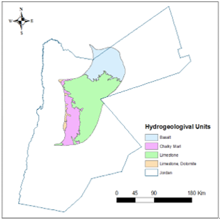
Located in the eastern desert of Jordan, the Azraq Wetland Reserve serves as a vital natural habitat for the preservation and protection of unique wild life within the potential Azraq Geopark, including both aquatic and terrestrial species. The primary aquifer in the Azraq basin area is the unconfined upper aquifer. It consists of various layers, which produce significant differences in the chemical and physical characteristics of the groundwater. The water in this aquifer differs in depth, quantity, and quality from one place to the other. Two geological formations are predominant within the boundaries of the Azraq Basin. The Basin is, therefore, separated into two zones related to the outcrop formation. The first one is found in the northern part of the Basin, or the quaternary basalt outcrop overlaying the aquifer A7/B (limestones of the Balqa and upper cretaceous Ajloun group), and the second zone in the south, or B4 formation (limestones of the lower Balqa group). However, the groundwater source from the aquifer has been heavily pumped in recent decades in order to match the increasing water demand because of the rapid population and economic growth, which of course led to a significant drop in water levels and quality within the targeted basin. This has disrupted the ecological systems' structure and behavior, many species have expanded, and the bird migration route started to change. The reserve is approximately 110 km east of Amman, as illustrated in Figure 1. This protected area is a distinct aqueous ecosystem found in a harsh and arid environment called "oasis," or "Waha" in Arabic, that offers a diverse natural habitat for exceptional aquatic and terrestrial species. Although the Oasis once had permanent freshwater springs, the demand for water for domestic use in Amman and the extensive pumping of water from the Oasis and groundwater through over 500 wells have resulted in a noticeable decline in the water table and soil and water quality degradation. In 1990, the Ramsar Advisory Mission identified the Azraq Wetland's crucial role in supporting raptors and waterfowl on the Palearctic-Ethiopian migration routes and its breeding site for approximately 70 bird species. The primary objective of this report is to raise awareness of the negative impact of human activities on the Azraq Basin and highlight the need for a conservation and management plan for the region's most critical wetlands, the Azraq Oasis. A management plan was developed in the early 1990s to recharge water into the Oasis to restore it to its former state, and long-term management objectives and recommended action plans should be established. The amount of rainfall in the basin fluctuates throughout the year, with an average annual rainfall of less than 50 mm/year in the Azraq Oasis area, and approximately 500 mm/year in the Syrian region. This results in a combined rainfall volume of 1075.9 million cubic meters (MCM). In an average rainfall year, this produces 12.5 MCM of flood flow, which can reach up to 32.54 MCM in wet years [2, 3]. However, floodwater is deposited in the mudflat layers consisting of clay, hindering natural recharge to the groundwater system in the central part of the basin through the drainage system.
Figure 1. Location map for Azraq basin and hydrogeological units
The Azraq Wetland Reserve in Jordan is critical in conserving diverse aquatic and terrestrial species. Among these, the Arabian toad (Bufotes variabilis) stands as an endemic amphibian species of protection concern, showing the reserve's ecological value. The Azraq killifish (Aphanius sirhani), a critically threatened freshwater fish unique to the region, thrives in the reserve's distinctive spring and Oiases ecosystems. Furthermore, during migration, the reserve is a vital stopover and breeding ground for the common eel (Anguilla anguilla), contributing significantly to the aquatic food web. Regarding avian diversity, the critically threatened sociable lapwing (Vanellus gregarius) uses the Azraq area as a vital wintering site during migration, underscoring the reserve's global importance for avian conservation. On the terrestrial front, the iconic Arabian oryx (Oryx leucoryx), a critically endangered antelope species, has been successfully reintroduced to the Azraq area, including the reserve, representing the area's value for the preservation of terrestrial wildlife. Additionally, the vulnerable Nubian ibex (Capra nubiana) thrives in the unique desert habitats of the Azraq region, further highlighting the area's ecological importance. These species collectively exemplify the rich biodiversity of the Azraq Wetland Reserve and highlight its crucial role in conserving aquatic and terrestrial ecosystems in the Azraq area [4, 5].
Azraq basin has the potential to be a geopark, but a major issue should be cleared first: the water situation within the basin. The groundwater is the main source of water in Jordan and in Azraq in this specific case [6-8], with three interconnected aquifer systems: the upper, middle, and deeper aquifer systems. The uppermost aquifer, which comprises the B4, B5, Basalt (Ba), and Quaternary formations, is exposed throughout the basin. The basalt formation stretches from the basin's central area towards the north. The middle aquifer is limited and primarily receives replenishment from the Arab mountain area. The deeper aquifer consists of a saline aquifer between B2/A7 and the Kurnub Sandstone aquifer, with poor water quality and low yield. The basin features a concave shape, with a mudflat known as the Azraq Oasis situated at the lowest and central point of the basin [9, 10] (Figure 1). Due to the topographical variations, in addition to other hydrogeological factors, groundwater levels within the upper aquifer can range from just a few meters in the center of the Azraq Oasis to as deep as 400 meters in the northern regions [11]. The occurrence and movement of groundwater are influenced by various natural factors, including slope, drainage patterns, landform, land use/land cover, and climate [12-14]. The climate is the main driver of water scarcity in Jordan and particularly in Azraq, but the population in the country has rapidly grown from 5.1 million in 2004 to around 12 million in 2021, resulting in increased water demand and pressure on the country's limited resources.
Groundwater levels have been steadily decreasing since the 1980s, resulting in the desiccation of key springs that once supplied water to the Azraq Oasis during the 1990s. The excessive exploitation of groundwater resources has resulted in a substantial decline in water levels in numerous wells, with the water table receding at an annual rate of 0.3 to 0.8 meters. A rise in salinity levels has been observed in groundwater wells in Azraq, and its association with water abstraction is being studied. Saltwater intrusion into groundwater can stem from various factors, including natural processes and human-induced activities. Over the past few years, a notable drop in water levels and productivity has been reported, mainly due to escalating operational expenses, especially energy costs, and increased water salinity. These challenges have resulted in lowering groundwater extraction rates, and regrettably, some farms in Azraq have been forced to stop farming [15].
Geographic Information System (GIS) is a powerful tool that can be used in water management. In water-related data analysis, GIS is essential in mapping water resources, conducting hydrological assessments, monitoring water quality, managing infrastructure, and assisting emergency response [16]. GIS technology allows water management professionals to collect, store, manage, analyze, and display water-related data on a geographic basis. By doing so, GIS provides water managers with the ability to make informed decisions and take necessary actions in addressing water resource issues. GIS can help water managers locate optimal routes for water pipelines, monitor water distribution, and detect leaks and breaks in the water supply network. GIS can also help to identify areas in the distribution network that are prone to low water pressure, which may result in water wastage and supply interruptions [17, 18]. GIS plays a crucial role in protecting data, identifying optimal zones, reducing site selection time and costs, and creating a digital database for future monitoring programs. One powerful GIS technique, multi-criteria decision analysis (MCDA), is a decision-making technique used in many fields, including GIS. MCDA involves analyzing a set of alternatives based on multiple criteria and then selecting the best option based on a set of decision rules. In the context of GIS, MCDA is used to combine and analyze multiple layers of spatial data, each representing a different criterion, to identify optimal zones or locations for a specific purpose. For example, in site selection for a new industrial plant, factors such as proximity to transportation networks, availability of a workforce, land costs, and environmental concerns can all be considered and weighted according to their relative importance. MCDA then combines the layers of data to create a composite score for each location, allowing decision-makers to identify the best site. Combines various spatial data layers based on specific criteria, making MCDA a powerful technique that can be used in a wide range of decision-making contexts. In GIS, MCDA can help identify optimal locations for a variety of applications, including site selection for new facilities, urban planning, natural resource management, and environmental conservation. GIS is particularly effective in water and environmental studies, as well as in the geotourism sector. The Azraq basin contains several hydraulic units for groundwater, with the upper aquifer facing severe overexploitation that leads to declining quality and quantity. The targeted area has volcanic basaltic cavities that exist within the wadis or nearby drainage locations, or on and above the wadis barriers. This study aims to explore the potential of these volcanic caverns to restore groundwater and protect it from flooding in the Qa'a area, where salinization and evaporation are major issues, in order to increase the availability of the water for the potential geopark in Azraq.
To check the study area's climate, the rainfall-runoff model (HEC-HMS model) was used. The Hydrologic Engineering Center's Hydrologic Modeling System (HEC-HMS) is a software package used for simulating rainfall-runoff processes in a certain watershed in order to present a comprehensive tool for hydrologic simulation that helps in some water related issues such as flood forecasting, reservoir management, and water supply planning. The HEC-HMS model in general works by taking weather data as input for the model, such as precipitation, temperature, and other climate information, and simulating the hydrologic cycle of a given watershed. The model accounts for various factors such as infiltration, evapotranspiration, and soil moisture storage, among others, to estimate the amount of runoff generated by a given rainfall event. The HEC-HMS model is a powerful tool for water resource management and planning. It can help water resource engineers and planners simulate various scenarios and assess the impact of different management options on the water balance of a watershed. It can also help to predict flood events and evaluate the effectiveness of flood control measures.
By applying the surface water harvesting model and evaluating the groundwater recharge amounts, the study sheds light on the water system within the basin, promoting sustainable water resources. This positive impact will also increase the investment potential of the basin as a geopark due to the numerous environmental, geological, and biodiversity conditions present there. Finally, to evaluate the runoff possibility, a hydrologic model was developed using the Hydrologic Modeling System of the Hydrologic Engineering Center [19]. The HEC-HMS model delivers a combination of options for simulating precipitation-runoff approaches. Applying the GIS tool with the HEC-HMS model, we produced maps for the potential geopark area in the Azraq basin and sub-basins layer and rasters for the area's distribution, slope, drainage density, and length. They were mapped to figure rainfall losses and excess, and the SCS (Soil Conservation Service) Unit Hydrograph approach to developing the runoff hydrograph [20].
Figure 2. A flowchart illustrating the methodology employed to identify potential groundwater recharge zones [21]
A hydrogeological model can be used to estimate the amount of groundwater recharge in an area based on the rock infiltration coefficient and rainfall amounts. Groundwater recharge refers to the process by which water from rainfall and other sources seeps into the ground and replenishes the water table. The rock infiltration coefficient is a measure of how quickly water can penetrate the rock or soil in a particular area. To estimate groundwater recharge using a hydrogeological model, a multiple parameter has been done by Multiple Influencing Factor (MIF) technique. Several steps were taken, starting with gathering information about the area's geology, hydrology, topography, soil, landuse, lineaments and climate, including rainfall data, the adapted methodology flowchart is shown in Figure 2 [21]. A weighting procedure is used to conduct a multi-criteria evaluation for potential groundwater zones. Each factor mentioned above is assigned a weight based on its significance in recharge. Significant factors are given a weightage of 1.0, while minor factors are assigned a weightage of 0.5. These factor weights are subsequently utilized as input data for the Weighted Overlay Analysis, a geospatial technique conducted within the ArcGIS environment. This analysis involves overlaying thematic maps, allowing for the development of comprehensive and weighted assessments [22].
A hydrogeological model was utilized to estimate the groundwater recharge value based on the rock infiltration coefficient and rainfall amounts. This model is particularly effective for arid and semi-arid regions, the following Eq. (1) was employed to calculate Groundwater Recharge (GWR) [23, 24]:
$\mathrm{GWR}=(\varnothing \times \mathrm{P}) / 100$ (1)
where, Ø is the infiltration rate and P is the precipitation in mm.
Then, determine the rock infiltration coefficient, which use the data collected to estimate the rock infiltration coefficient for the area. This can be done using various methods, such as field tests, laboratory tests, or empirical equations. The estimated recharge value should be validated by comparing it with actual groundwater levels in the area (Table 1). If the estimated recharge value is significantly different from the actual groundwater levels, the model should be adjusted accordingly. The potentiality of groundwater refers to the ability of an aquifer to sustainably provide water for various uses such as domestic, agricultural, industrial, or environmental purposes. The potentiality of groundwater is determined by several factors, including the geological and hydrological characteristics of the aquifer, recharge rate, discharge rate, water quality, and climate [19, 20, 23-25]. Accordingly, a potentiality study of groundwater recharge was conducted before based on the targeted area's hydrological and hydrogeological characteristics. By assigning appropriate weights to various factors, the capacity of groundwater was assessed, and managed aquifer recharge was implemented in the region. The findings of the research indicate that regions with mild surface gradients are conducive to recharge, and soil with high permeability effectively retains water and boosts infiltration.
Table 1. Coefficient of infiltration given in % for different type of rocks [19, 20]
|
Type of Rock |
Coefficient of Infiltration % |
Infiltration |
|
Gravels, Alluvium |
6 |
High |
|
Sandstone, Basalt, Sandy loam, Silt, Marl, Clay loam, Clayey sand, Sandy clay |
4 |
Moderate |
|
Limestone, Dolomite |
2 |
Low |
|
Gypsum, Clays, Silt, Soils |
1 |
Very low |
By conducting a comprehensive analysis of the climate patterns in the study area, characterized by hot summers and cold winters, the Rainfall-Runoff Model (HEC-HMS Model) was utilized. Examination of precipitation data spanning three decades (1990-2020) revealed that the average annual precipitation in the potential geopark area ranges from 50 to 120 mm. Rainy season in Jordan is considered from September to May, rainfall data from different sources were collected to evaluate the average precipitation during the targeted period. However, approximately 90% of the precipitation is lost through actual evaporation, leaving only around 10% for runoff and recharge, mainly occurring through flash floods. To estimate the potential for runoff, the Hydrologic Modeling System of the Hydrologic Engineering Center was employed. Among the various options available in the HEC-HMS model for simulating precipitation-runoff processes, the NRCS Unit Hydrograph (UH) method was chosen to simulate sub-basin runoff hydrographs and the catchment's outflow hydrograph. The basin was divided into two aquifer sections (B4 and Basalt), with the infiltration coefficient calculated as 5 for the highly permeable basaltic rocks in the Azraq area, while it was 4 for the B4 limestone aquifer.
The declining water table in the Azraq area significantly affects the ecosystem and water resources. From an ecological viewpoint, this water level drop reduces habitat and endangers various flora and fauna adapted to wetland ecosystems. Biodiversity is threatened as species dependent on these habitats for breeding, foraging, or shelter. The wetlands in Azraq are notably critical for migrating birds, and the decline in water level will disrupt bird migration patterns. Additionally, declining water levels can create conditions favorable to invasive species, potentially changing the composition of local ecosystems. The dwindling water table directly impacts freshwater availability, leading to water scarcity that affects domestic, agricultural, industrial, and commercial needs.
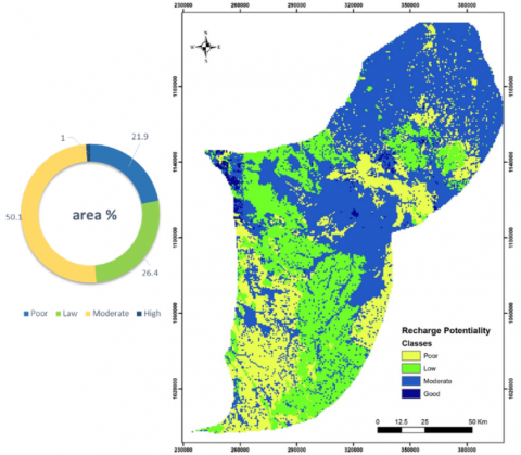
Figure 3. Groundwater potentiality map after applying the MIF technique and the percentages of each class
Applying the MIF technique, resulted in producing the potentiality map shown in Figure 3, after determination of weightage through the consideration of multiple influencing factors, the assignment of these derived weight values and rankings to all thematic layers during the weighted overlay analysis conducted within the ArcGIS, producing a consolidated weight map for the potential groundwater recharge areas. It's important to note that the basin shows a moderate potential for groundwater recharge based on its hydrogeological characteristics with a percentage of 50.7% of the total area, 21.9% and 26.4% foe poor and law classes as shown in Figure 3. However, although the map shows high potential areas for groundwater recharge in only around 1%, but the aquifer still faces limitation in recharge amounts due to limited rainfall; also, the map shows that the region with moderate potential for recharge within the basin are areas characterized by gentle topography of less than 5 degrees; also, soils with high permeability effectively retain and facilitate water percolation and infiltration, acting as driving forces for recharge.
Employing the earlier mentioned equation, the average infiltration for the basaltic aquifer was estimated to be 15 million cubic meters (MCM), whereas for the B4 aquifer, it was found to be 11.12 MCM. Nevertheless, the basin is currently facing significant water table drawdown, with an average decline of 1 meter per year, primarily due to excessive groundwater extraction. Consequently, the ecosystem is undergoing severe deterioration. Surface water availability is estimated to be 320,000 cubic meters annually under typical year-round conditions. To prevent further degradation, it is crucial to explore innovative solutions such as utilizing volcanic basalt caves for nonconventional water storage to minimize evaporation and salinization risks. Additionally, artificial recharge techniques using these caves should be investigated. A noteworthy addition to the groundwater potentiality map is the identification of the high potential areas associated with the basaltic caves’ aquifer. Incorporating this valuable information enhances the study and offers opportunities for improving groundwater recharge while safeguarding water resources from excessive evaporation and surface losses.
In conclusion, the establishment of a geopark in the Azraq area relies heavily on the preservation of sustainable water resources. Geoparks are dedicated to showcasing the rich geological, ecological, and cultural diversity of a region, with water resources playing a vital role in supporting the intricate balance of ecosystems and communities. By actively promoting water conservation and implementing effective management strategies, the achievement of sustainable water resources becomes a pivotal factor in enhancing the geopark concept in Azraq. Establishing a geopark in Azraq is facing potential limitations; not only the limited water resources is the problem, but also the fragile balance between tourism development and the environmental protection of the unique geological and ecological features of Azraq is critical. Highlighting this balance necessitates careful planning and strict environmental impact assessment studies to prevent degradation and the disturbance of sensitive ecosystems. Also, engaging the local communities and encouraging active participation in the geopark's management is critical for its long-term success. However, it may face challenges associated with resource allocation and community empowerment. Balancing the objectives of tourism, environmental conservation, and water resource sustainability will require comprehensive planning, cooperation among different stakeholders, and adaptive management methods to address these potential constraints effectively. Efficient aquifer management in the Azraq Basin offers several benefits, it significantly improves water recharge rates, replenishing groundwater resources more effectively. From other hand, the well-planned aquifer management can mitigate water table drawdown, thus conserving the resilience of aquifer systems, this is essential for sustaining ecosystems that rely on groundwater, preventing land subsidence, and protecting the quality of water resources. Moreover, efficient aquifer management is pivotal in reducing water scarcity risk and providing a reliable supply for domestic, agricultural, and industrial use. Nevertheless, implementing these techniques implicates overcoming various challenges. Managing water resources necessitates careful coordination among stakeholders, including local communities, governments, and environmental organizations. Moreover, there is a need for continuous monitoring and adaptive control to manage the dynamic aquifer systems and the developing environmental conditions. This concerted effort not only appeals to geotourism enthusiasts seeking unique experiences but also engenders substantial benefits for local communities by safeguarding their access to clean water and essential resources. It is required to balance the water requirements of a growing population with the existing resources to protect the aquifer and stress the importance of aquifer management as a sustainable solution in the Azraq Basin. Recognizing the profound importance of sustainable water resources is paramount for ensuring the long-term well-being of the region. Furthermore, adopting more efficient aquifer management practices, such as managed aquifer recharge or the utilization of basalt rock caves for water storage and subsequent recharge, holds the potential to significantly increase the current recharge rate of 26 MCM. As there is a raised risk of saltwater intrusion and groundwater contamination as the water table declines. These issues can escalate costs for agriculture, water supply, and infrastructure. Eventually, declining water tables' economic, societal, and environmental consequences necessitate sustainable water management practices and cooperative efforts among communities, authorities, and conservation organizations to protect water needs and ecosystem health in the Azraq area. Leveraging the abundant potential of the basaltic area as a rechargeable water source can profoundly enhance the water situation within the basin, thus bolstering the prospects of establishing Jordan's inaugural geopark. This, in turn, exerts a positive influence on the environmental and socioeconomic aspects of the area, fostering a sustainable and thriving future.
This paper was a part of IGCP Project 730: Hydrogeological Significance of Mediterianian Geoparks project funded by UNESCO.
[1] Dowling, R.K. (2014). Global geotourism—An emerging form of sustainable tourism. Czech Journal of Tourism, 2(2): 59-79. https://doi.org/10.2478/cjot-2013-0004
[2] Ali Rahmani, S.E., Chibane, B., Boucefiène, A. (2017). Groundwater recharge estimation in semi-arid zone: A study case from the region of Djelfa (Algeria). Applied Water Science, 7: 2255-2265.
[3] Alkhatib, J. (2017). An integrated approach of analyzing management solutions for water crisis in Azraq Basin, Jordan. Ph.D. dissertation. Georg-August University, Germany.
[4] The IUCN red list of threatened species. https://www.iucnredlist.org/, accessed on Feb. 19, 2022.
[5] Smith, K.G., Barrios, V., Darwall, W.R., Numa, C. (2012). The Status and Distribution of Freshwater Biodiversity in the Eastern Mediterranean. IUCN.
[6] Mohammad, A.H., Odeh, T., Halalsheh, M., Shatanawi, K. (2021). Detecting Land use/cover dynamics and land suitability mapping for Irbid governorate using an integrated approach. Journal of Environmental Engineering and Landscape Management, 29(3): 263-272. https://doi.org/10.3846/jeelm.2021.15150
[7] Mohammad, A.H., Wisam, H., Khaldoun, S., Mahmoud, A. (2020). Quantity not quality: Promoting sustainable wastewater practices in Jordan. Water Policy, 22(3): 435-448. https://doi.org/10.2166/wp.2020.195
[8] Mohammad, A.H., Jung, H.C., Odeh, T., Bhuiyan, C., Hussein, H. (2018). Understanding the impact of droughts in the Yarmouk Basin, Jordan: Monitoring droughts through meteorological and hydrological drought indices. Arabian Journal of Geosciences. https://doi.org/10.1007/s12517-018-3433-6
[9] Al-Kharabsheh, A. (2020). Challenges of Sustainable Water Management in Jordan. Jordan Journal of Earth and Environmental Sciences, 11(1): 38-48.
[10] Al-Kharabsheh, A. (1991). Hydrogeological and hydrochemical study of the upper aquifer system in Azraq Basin (Jordan). Doctoral dissertation. Yarmouk University, Jordan.
[11] Ayed, A. (1996). Surface water resources in Azraq Basin. Unpublished Report, Water Authority, Amman, Jordan.
[12] Al-Kharabsheh, A. (1995). Possibilities of artificial groundwater recharge in the Azraq Basin: Potential surface water utilization of five representative catchment areas (Jordan). Doctoral dissertation. Lehr-und Forschungsbereich Hydrogeologie und Umwelt.
[13] Odeh, T., Alakhras, A.I., Habib, M., Alduaij, O., Mohammad, A.H., Alslaty, F. (2022). A recommended urban plan according to flash flood risk potential map: The case study of mecca province - Saudi Arabia. International Journal of Sustainable Development and Planning, 17(3): 737-742. https://doi.org/10.18280/ijsdp.170304
[14] Odeh, T., Mohammad, A.H., Pradhanang, S.M., Ismail, M., Rödiger, T. (2022). GIS-based analytical modeling on evaluating impacts of urbanization in Amman water resources, Jordan. Environmental Earth Sciences, 81: 160. https://doi.org/10.1007/s12665-022-10238-7
[15] Mesnil, A., Habjoka, N. (2012). The Azraq-dilemma: Past, present and future groundwater management. https://wocatpedia.net/images/c/ca/GIZ%2C_Mesnil%2C_Habjoka_2012_azraq-dilemma.pdf, accessed on Aug. 19, 2023.
[16] GIS for Water. https://www.esri.com/en-us/industries/water/overview, accessed on Sep. 22, 2023.
[17] Hydrologic modeling system HEC-HMS, user’s manual. US Army Corps of Engineers. https://www.hec.usace.army.mil/software/hec-hms/documentation/HEC-HMS_Users_Manual_3.5.pdf, accessed on Aug. 19, 2023.
[18] Shawaqfah, M., Alqdah, I., Nusier, O.K. (2015). Water resources management using modeling tools in desert regions: The Azraq Basin, Jordan. International Journal of Modeling and Optimization, 5(1): 55-58.
[19] Banton, O., Bangoy, L.M., Chevalier, S., Houenou, P.V., Lafrance, P., Rivard, C. (1997). Hydrogéologie: Multiscience Environnementale des Eaux Souterraines. Presses de l'Université du Québec, Québec.
[20] Gilbert, C. (1982). Principes et Méthodes de l’Hydrogéologie. Dunod, Paris.
[21] Raviraj, A., Kuruppath N., Kannan B. (2017) Identification of potential groundwater recharge zones using remote sensing and geographical information system in Amaravathy Basin. Journal of Remote Sensing & GIS, 6: 213. https://doi.org/10.4172/2469-4134.1000213
[22] Patil, S.G., Mohite, N.M. (2014). Identification of groundwater recharge potential zones for a watershed using remote sensing and GIS. International Journal of Geomatics and Geosciences, 4(3): 485-498.
[23] Rapp, M. (2008). Evaluation of potential sites for managed aquifer recharge via surface infiltration in NW-Jordan. Unpublished diploma thesis. Department of Applied Geology (AGK), University of Karlsruhe (TH), Karlsruhe, Germany.
[24] Mohammad, A.H., Odeh, T. (2016). A modified modeling of potentiality and vulnerability of the groundwater resources in Amman Zarqa Basin, Jordan. Kuwait Journal of Science, 43(1): 208-221.
[25] Yeh, H., Cheng, Y., Lin, H., Lee, C. (2016). Mapping groundwater recharge potential zone using a GIS approach in Hualian River, Taiwan. Sustainable Environment Research, 26(1): 33-43. https://doi.org/10.1016/j.serj.2015.09.005