Alaa H. AbdUlameer*![]() | Ali Omran Al-Sulttani
| Ali Omran Al-Sulttani![]()
© 2023 IIETA. This article is published by IIETA and is licensed under the CC BY 4.0 license (http://creativecommons.org/licenses/by/4.0/).
OPEN ACCESS
Shatt Al-Hillah is Iraq's largest and most important Euphrates River irrigation system. From Al-Hindiyah Barrage to Al-Dagharah Regulator, it rises 100 kilometers left of the Euphrates River. It is controlled by Shatt Al-Hillah Head Regulator, which has a design discharge of 350 m3/s. This river is used for agricultural, industrial, and municipal reasons, and it is considered a tourist attraction. To meet agricultural, municipal, and industrial needs, water amounts must be verified regularly. Climate change and a lack of upstream revenues have reduced water levels in Shatt Al-Hillah. This study proposes water distribution solutions by computing the minimum instream flow (MIF) to ensure irrigation project water shares in Shatt Al-Hillah Basin and the water level upstream of the Al-Dagharah Regulator to meet water requirements in Shatt Al-Diwaniyah basin. The hydraulic model required field measurements. It contained Shatt Al-Hillah River cross-sections, drainages, and water levels. River Analysis System HEC-RAS 5.0.7 software simulated flow in the research area using a one-dimensional hydraulic model. Three scenarios have been provided to compute the lowest instream flow discharged from the downstream head regulator (Shatt Al-Hillah Regulator) following model calibration and verification. The results showed that all intakes of irrigation networks along the river in the research region can release 99 m3/s with a consumption discharge of 48.67 m3/s utilizing a 3-day irrigation interval. For all intakes with a consumption discharge of 32.5 m3/s, an irrigation interval of two days per week can release 83 m3/s. According to the database of discharge releases from Shatt Al-Hillah Regulator for the last three years, the river flow rate at the head regulator is 90 m3/s, so the third scenario with 83 m3/s and a two-day per week irrigation service interval is recommended.
water requirements, HEC-RAS, minimum instream flow, Shatt Al-Hillah
The two ancient rivers that define Mesopotamia are the Tigris and the Euphrates, which originate in the neighboring countries. At Shatt Al-Arab, the two rivers meet, and from there, water flows directly into the Persian Gulf [1]. Tigris and Euphrates are its two main rivers, and there are numerous smaller tributaries. The upper reaches and headwaters of the two rivers are located in the mountains of eastern Turkey. To the heights of Syria across valleys and passes and northern Iraq, and then sedimentary plain in central Iraq. Because it is a portion of the Fertile Crescent, where it is thought that the Mesopotamian civilization initially appeared, the area has historical significance. The most prevalent fish in fisheries are stinging (brown) fish, which have long been a significant source of food for the human population [2]. The majority of Iraq's cities as well as a sizable chunk of its populace are situated along or close to the Tigris and Euphrates rivers. In terms of residential water use, the Euphrates and Tigris rivers are crucial. For economic activity, they are necessary resources. Recent over the years, a significant increase in the importance of assessing the quantity and quality of water in emerging nations, especially in light of worries that fresh water would become a scarce resource in the future [3]. Water needed to maintain the structure and function of aquatic ecosystems at a constant value is referred to as "instream flow," a general and often used term. Environmental flow is another word that is occasionally used [4, 5]. According to the definition of an instream flow requirement, it is the amount of water required to retain the established and planned in-place uses of the water in the stream channel or the other body of water and as well as to sustain the aquatic system's natural characteristics and its dependent systems [6]. By employing HEC-RAS software 5.0.7, a one-dimensional hydraulic model for Shatt Al-Hillah reach was created. To collect the discharge for a period through July 2022, 4 sites were divided equally. The hydraulic model was first calibrated, and the river’s in steady-state, the manning roughness was 0.026. Next, the calibrated the hydraulic model over a variety of time periods. Finally, the model was simulated to forecast the discharge capacity values over a variety of time periods for both assumed and actual flow rate values.
The amount of water needed to maintain an aquatic ecosystem's biological values while posing little risk is known as the environmental flow. Although it is popular acknowledged that human water demands and river needs must be matched, conflicts over the allocation of water resources are expanding as a result of both rising human demand and ambiguous river ecosystem water needs [7]. Minimum instream flow criteria are frequently based on a mix of the following in practice: historical discharge, shape of the channel, water quality, aquatic species ecology, modeling, empirical data, and ultimate adjudication between user groups. The actual rules may be as simple as a statement of the minimum depth of the water or as detailed as detailed descriptions of flows that change depending on environmental, socioeconomic, and important species' life cycles. The amount of instream flow needed in a specific place will rely on regional conditions as well as conditions downstream, and these conditions might differ significantly even within regions with similar hydrology and temperature [8]. Using the analysis of remote sensing pictures, which enables consideration of the change in land use and vegetation coverage it was explored how much ecological flow was necessary (i.e., how much water the ecosystem). In calculating the ideal flow for a sustainable ecosystem, the river's geophysical and hydraulic characteristics are crucial [9]. The amount of water moving through a channel at a specific location and time is known as the instream flow. An official water entitlement for instream purposes is an instream flow reservation. The channel form, aquatic and riparian flora and fauna, and also water quality, and estuary habitats are all significantly influenced by instream flows [10, 11]. Management organizations are implementing instream flow specifications for vital aquatic habitats as a result of growing rivalry for water resources in dry and semi-arid watersheds. to maintain numerous vital spawning and rearing reaches, minimum instream flows are required [12].
Over the previous century, the number of people has increased at a rate less than half that of water use and competition among users. For instance, irrigation One of the activities that has been ranked as being the one most use a significant quantity of freshwater sources in many areas, using around 70-80% of the actual amount of freshwater available worldwide [13]. The phrase "instream flows" and "off stream flows" there have developed to differentiating between flows for use within the river bed and those for use elsewhere (off stream uses). For both natural and recreational purposes (instream uses), instream flows safeguard the water quality and aquatic life while preserving the fluvial environment; off stream flows are often used for drinking water, traditional irrigation, industrial, and hydroelectric purposes (off stream uses). Now that there is such a clear Incompatibility between the two uses of the common water resource, legal action is required [14]. Calculations for steady and unsteady flow rivers in one dimension (1-D) can be made using the HEC-RAS model. It is one of the models that is most frequently employed 1-D, steady-state, increasing-varying flow analysis to compute water-surface profiles and energy grade lines. HEC-RAS model replaces and is compatible with the HEC-2 model [13, 15]. Four categories of instream flow (IF) assessment techniques exist: hydrologic. The hydrologic and hydraulic procedures are the ones that are used the most frequently. The results of this study showed that it is possible to release a discharge of about 99 m3/s when using an irrigation interval of 3 days a week for all intakes of irrigation networks along the river in the study area, with a consumption discharge of 48.67 m3/s. Also, it is possible to release a discharge of 83 m3/s when using an irrigation interval of two days per week for all intakes with a consumption discharge of 32.5 m3/s. Therefore, it is recommended to use the third scenario with the flow rate of 83 m3/s and an irrigation services interval of 2 days per week. Because the actual discharge currently in Shatt Al-Hillah is 90 m3/s.
2.1 Study area
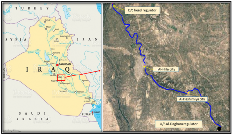
The capital of Iraq, Baghdad, is located around 100 kilometers south of Shatt Al-Hillah. Shatt Al-Hillah, one of the Euphrates River's main branches, covers a length of 100 km from Babylon Province to Diwaniyah Governorate. An important source of water for the nearby cities is Shatt Al-Hillah; during operation, the flowrate varied from 200 m3/s at Al Hillah Head Regulator to 45 m3/s at Shatt Al-Hillah Regulator. The scope of the study area reach begins in downstream of the Al-Hillah Regulator to upstream of the Al-Dagharah Regulator [16, 17]. In light of this, Shatt Al-Hillah has a significant amount of potential to draw investors and is well adapted to the growth of a tropical agricultural economy. This change causes Shatt Al-Hillah and agricultural environments to become more and more polluted by the industrial and agricultural discharges. A study's location area is shown in Figure 1. Water resource projects that are ongoing are currently in the design and planning stages. As a result of the decreased surface water coming from the nearby countries of Turkey and Iran. Nearly all of the rivers in Iraq have lower water quality and quantity than average. This resulted in the requirement for research of the necessary activities that must be made to determine how much water is being lost from these waters will serve as a great tool for more thorough research and the planning of the necessary steps to resolve this scenario. The results of this study may be helpful for those studies for project planners and decision-makers. This research is one of the contributions that may provide a future estimation of the probability of some of the water quantity of Shat Al-Hillah River. As a result, this river was chosen for the current analysis [18, 19]. According to the study [20], Shatt Al-Hillah in Iraq employed the Tennant method and river analysis systems (HEC-RAS) to estimate the optical ecological flow rate and minimum instream flow rate.
Estimating the amount of water that must flow through a river to keep it at a specific level of conservation is known as minimum instream flow. When considering the environmental effects of large-scale engineering projects like impoundments and inter basin transfer schemes, instream flow requirements (IFR) are a crucial factor. According to the study [10], Water quality, riparian and aquatic life, estuary influx, and stream load transport are all significantly influenced by instream flows. Estimating the amount of water that must flow through a river to keep it at a specific level of conservation is known as instream flow [21].
Figure 1. Location of the study area
2.2 Water sampling and analysis
Collecting the necessary information on the discharges at Shatt Al-Hillah intakes and regulators, as well as surveying information about the cross-sections along Shatt Al-Hillah reach within the Babylon Governorate Discharge data were collected from Al-Hillah and Al-Diwaniyah cities Department of Water Resources in 2022. The discharge was calculated and the water level was measured.
Water levels, which differ from region to region along Shatt Al-Hillah that flows from the Euphrates River, are one of the essential hydrological parameters in Shatt Al-Hila situation. The study area contains a number of wireless hydrological monitoring stations with their specific locations. Using the data gathered for various flow situations as inputs for HEC-RAS program to develop hydraulic models by simulating the hydraulic properties. Establishing and approving the HEC-RAS model. In order to estimate the minimum instream flow, analyze the hydraulic model's output findings. Discussing the findings to come to the best conclusions and suggestions for further research [22].
2.3 Statistical techniques for calculating the minimum instream values of flow
In the current study, various analytical methods, including hydrologic method and hydraulic rating were used to research the quantity of water that was required to determine the ideal environmental flow that needs to be supplied from Shatt Al-Hillah location and the minimum water depth necessary to protect this basin's ecosystem. Historic methods, such as the River Analysis Systems (HEC-RAS) were used to estimate the minimum instream flow rate [9].
2.4 River analyses systems (HEC-RAS)
HEC-RAS is an open-channel, one-dimension flow, adjustable boundary created a model for numerical simulation and forecast profiles of rivers have changed. Using equation for energy and continuity in one dimension solution serves as the basis for the computational process for water surface elevation in HEC-RAS. Friction measures energy losses. (Manning’s equation) and when the water surface profile is rapidly changing, the momentum equation is used. These calculations require the following information: cross-sectional geometries, reach lengths, loss coefficients, Manning's roughness, beginning elevation, flow regime, and discharge [9, 23, 24].
2.5 Model description
For natural channels, the Saint-Venant equations are solved by the HEC-RAS model [25].
dAdt+dQdx=ql (1)
∂Q∂t+∂(Q2 A)∂x+gA∂H∂x+gASf (2)
where, the cross-section area orthogonal to the flow; Q=discharge; ql=the tributary's lateral flow; g=Gravitational acceleration; H=Surface elevation of the water above a given datum; Sf=the slope of friction at the longitudinal boundary; t=the temporal coordinate; x=longitudinally coordinate. Applying the popular four-point implicit box finite element method, Interior points are used to evaluate space derivatives and function values. For a river reach, equations are resolved. For readers who are interested, [25] provided details on application of the implicit box finite difference technique to the Saint-Venant problem [9].
2.6 Model application
Boundary conditions, tributary inflows, channel shape, and channel resistance are the required input data for water level simulation. Data on discharge and water level at different places along the projected reach were used to evaluate the effectiveness of the HEC-RAS model. The value is calibrated using cross-sections and the observed discharge, a suitable Manning's n value was found. Relating to the channel's geometry. A suitable Manning's n value range was used for the scenario analysis [9, 23].
2.7 A Case study of the Euphrates River (Shatt Al-Hillah River)
Geometry and discharge of Shatt Al-Hillah
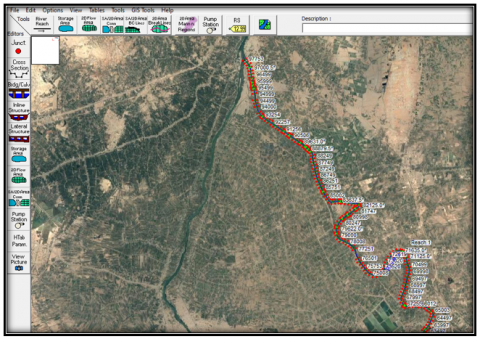
The length of the study area reach is measured from the Al-Hillah Regulator downstream to Al-Dagharah city upstream. The entire length of Shatt Al-Hillah was divided into 4 stations spread among the major cities. Figure 2 shows the layout within the river. The present study, the flow data from Shatt Al-Hillah were analyzed using the hydrological and hydraulic rating approaches. In order to study the available discharge required for a chosen minimum instream flow from Shatt Al-Hillah, a classic case of using HEC-RAS model techniques was used, as shown in the research. Shatt Al-Hillah water is mostly used in Babylon Province to provide the needs to produce electrical energy, irrigation water, and water sports activity. Information on hydraulic and geometry data is needed for the construction of hydraulic models. HEC-RAS software version 5.0.7 was used in this work to simulate the hydraulic model. HEC-RAS, system of river analysis created by the Center for Hydrologic Engineering to assist the US modifications to Engineers Corps of the Army in 2016 one- and two-dimensional flow simulation computations. The informational data and procedures utilized to create the hydraulic model are described in this section [22, 23].
In this study, HEC-RAS software was utilized to derive water depths and flow velocity for a specific cross-section using a number of carefully chosen flow rates. For that particular cross-section, these flow rates were used to regress these water depths and speeds using Eqns. (1) and (2). The analyzed rivers' cross sections all underwent the same calculations. For each river segment, Water depth and flow rate were computed using these hydraulic constants at the simulation flow rate [26]. The geometry information of Shatt Al-Hillah inside the research region is needed for the one-dimensional hydraulic model simulation. In this study, 393 along the river, cross-sections were distributed with a distance interval of 250 m, also the survey results of the cross-sections were measured by the Department of Water Resources. The data include the coordinates of the river, the data of the available cross-sections, and the data of discharge. Information on the Shatt Al-Hillah 2007 cross-sections and coordinates. Information about Shatt Al-Hillah Al-hydraulic conditions and water levels.
Figure 2. HEC-RAS geometry window’s of one-dimensional river scheme
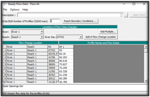
Figure 3. The HEC-RAS steady flow of one-dimensional river scheme
Figure 4. Water level along the reach in Scenario 3, summer season
Figure 5. HEC-RAS profile plot for scenario 3 in summer season
Model calibration and validation using data acquired from observed data. In order to assess a river, it must be depicted at various operational flowrates throughout a range of times. With this study, Shatt Al-Hillah observed flow rate figures were used to replicate conditions during the dry season. 99 m3/s and 83 m3/s, respectively, were the used flowrate values at the headwaters and downstream of the river during the summer time. The geometry window of the HEC-RAS software is shown in Figure 2 with the river scheme in one dimension. The steady flow input data in Shatt Al-Hillah is shown in Figure 3. It shows the scheme of the river and intake in scenario 3 within the study area.
Calibration and validation of the HEC-RAS model using data acquired from observed data and selected coefficient of roughness Appropriate. The lowest permissible discharge rate was calculated within the Al-Dagharah Regulator and the corresponding water level, and based on that, several scenarios were imposed to obtain the required water level. The hydraulic model was simulated during the dry season and the obtained results were compared with the value of the minimum water level in Al-Dagharah Regulator. In the river, flowrate was measured for many scenarios, and the first scenario was simulating the water quantity model for the dry season (148 m3/s for Shatt Al-Hillah), and the second scenario was simulating the model (99 m3/s for Shatt Al-Hillah). The third scenario was simulating the model (83 m3/s). The Iraqi Ministry of Water Resources established the measured flow rate values based on the study "Data on flowrate) and hydraulics information of Shatt Al-Hillah (2021-2022)".
Figure 4 shows that the variation in water levels along Shatt Al-Hillah in the scenario. It must be noticed that the discharge of 83 m3/s during summer is required to get water level of 22 m.a.m.s.l. at Al-Daghara city as minimum acceptable water level. Figure 5 shows the relationship between the water surface elevation and the total distance of Shatt Hillah with stability of the cross sections along the river and the hydraulic structures. When the discharge is 83 m3/s with an irrigation interval of two days each week. This figure illustrates that the best scenario is the third one.
The absence of hydrological water stations along Shatt Al-Hillah River within the study area leads to the use of the only available data at Al-Hillah Head Regulator and Al-Dagharah stations. These two stations were used to check the measured data that was accomplished through 4 main hydrological stations along the river reach during summer (July, 2022). The current study was deduced the following conclusions:
The authors would like to thank Al- Hillah and Al-Diwaniyah Departments of Water Resources for providing monitoring data. I extend my thanks and appreciation to University of Baghdad, College of Engineering, Department of Water Resources, for the efforts exerted to support the researchers.
[1] Koyuncu, C.E., Yilmaz, H., Secer, F.S., Kaya, D., Genc, E. (2021). Fish parasites of tigris and euphrates river systems. Tigris And Euphrates Rivers: Their Environment from Headwaters to Mouth, 1389-1417. https://doi.org/10.1007/978-3-030-57570-0_68
[2] Smith, K.G., Darwall, W., Barrios, V., Numa, K., Isfendiyaroğlu, S. (2014). Background to freshwater biodiversity in the eastern mediterranean. The status and distribution of freshwater biodiversity in the eastern Mediterranean. Cambridge (UK), Malaga (Spain) and Gland (Switzerland): International Union for Conservation of Nature (IUCN), 1-7.
[3] Al-Shujairi, S.O.H. (2013). Develop and apply water quality index to evaluate water quality of Tigris and Euphrates Rivers in Iraq. International Journal of Modern Engineering Research, 3(4): 2119-2126.
[4] MacKay, H., Moloi, B. (2002). The importance of instream flow requirements for decision making in the Okavango River Basin. In Proceedings of first workshop, Green Cross International Water for Peace Project: Okavango Pilot Project, Maun, Botswana, September.
[5] Abbas, S.H., Khudair, B.H., Jaafar, M.S. (2019). River water salinity impact on drinking water treatment plant performance using artificial neural network. Journal of Engineering, 25(8): 149-159. https://doi.org/10.31026/j.eng.2019.08.10
[6] Reiser, D.W., Wesche, T.A., Estes, C. (1989). Status of instream flow legislation and practices in North America. Fisheries, 14(2): 22-29. https://doi.org/10.1577/1548-8446(1989)014<0022:SOIFLA>2.0.CO;2
[7] Peng, L., Sun, L. (2016). Minimum instream flow requirement for the water-reduction section of diversion-type hydropower station: a case study of the Zagunao River, China. Environmental Earth Sciences, 75(17): 1-8. https://doi.org/10.1007/s12665-016-6019-1
[8] Scatena, F.N. (2004). A survey of methods for setting minimum instream flow standards in the Caribbean Basin. River Research and Applications, 20(2): 127-135. https://doi.org/10.1002/rra.738
[9] Elhatip, H., Ali Hinis, M. (2015). Statistical approaches for estimating the environmental flows in a river basin: case study from the Euphrates River catchment, Eastern Anatolian part of Turkey. Environmental Earth Sciences, 73(8): 4633-4646. https://doi.org/10.1007/s12665-014-3748-x
[10] Estes, C.C., Orsborn, J.F. (1986). Review and analysis of methods for quantifying instream flow requirements 1. JAWRA Journal of the American Water Resources Association, 22(3): 389-398. https://doi.org/10.1111/j.1752-1688.1986.tb01893.x
[11] Vaidya, S.D., Kelkar, P.S., Mhaisalkar, V.A. (2008). Minimum flow requirement for fish population affected by dam construction in temperate areas. International Journal of Sustainable Development and Planning, 3(3): 293-306. https://doi.org/10.2495/SDP-V3-N3-293-306
[12] Barber, M., Mahler, R. (2018). Uncertainty in minimum instream flow requirements for streams in semi-arid environments. Water Studies, 301.
[13] Serede, I.J., Mutua, B.M., Raude, J.M. (2015). Hydraulic Analysis of Irrigation Canals using HEC-RAS Model: A Case Study of Mwea Irrigation Scheme, Kenya‖. International Journal of Engineering Research & Technology, 4(9): 989-1005.
[14] Ubertini, L., Manciola, P., Casadei, S. (1996). Evaluation of the minimum instream flow of the Tiber River Basin. Environmental monitoring and assessment, 41(2): 125-136. https://doi.org/10.1007/BF00394339
[15] Dhungel, S., Barber, M.E., Mahler, R.L. (2019). Comparison of one-and two-dimensional flood modeling in urban environments. International Journal of Sustainable Development and Planning, 14(4): 356-366. https://doi.org/10.2495/SDP-V14-N4-356-366
[16] Hussein, T.S., AL-Thamiry, H.A.K. (2022). Evaluation and Development of the (Hilla–Daghara) Rivers System. Journal of Engineering, 28(2): 46-62. https://doi.org/10.31026/j.eng.2022.02.04
[17] Hussein, T.S., AL-Thamiry, H.A.K. (2022). Evaluation and Development of the (Hilla–Daghara) Rivers System. Journal of Engineering, 28(2): 46-62. https://doi.org/10.31026/j.eng.2022.02.04
[18] Al-Suhili, R.H. (2018). Frequency analysis of some of water quality parameters of Shatt Al-Hilla River, Iraq. Am. J. Eng. Res, 7: 190-199.
[19] Mosawi, M.A., Al Thamiry, H. (2022). Evaluation of Elaj Irrigation Project in Babil Governorate. Journal of Engineering, 28(8): 21-33. https://doi.org/10.31026/j.eng.2022.08.02
[20] Lee, S., Kim, J., Hur, J.W. (2013). Assessment of ecological flow rate by flow duration and environmental management class in the Geum River, Korea. Environmental Earth Sciences, 68: 1107-1118. https://doi.org/10.1007/s12665-012-1812-y
[21] Song, J.X., Xu, Z.X., Liu, C.M., Li, H.E. (2007). Ecological and environmental instream flow requirements for the Wei River—the largest tributary of the Yellow River. Hydrological Processes: An International Journal, 21(8): 1066-1073. https://doi.org/10.1002/hyp.6287
[22] Abed, B.S., Daham, M.H., Al-Thamiry, H.A. (2020). Assessment and Modelling of Water Quality along Al-Gharraf River (Iraq). Journal of Green Engineering, 10: 13565-13579.
[23] Daham, M.H., Abed, B.S. (2020). One and two-dimensional hydraulic simulation of a reach in Al-Gharraf River. Journal of Engineering, 26(7): 28-44. https://doi.org/10.31026/j.eng.2020.07.03
[24] Asaad, B.I., Abed, B.S. (2020). Flow Characteristics of Tigris River Within Baghdad City During Drought. Journal of Engineering, 26(3): 77-92. https://doi.org/10.31026/j.eng.2020.03.07
[25] Us Corps of Engineers (2010). HEC-RAS, River analysis system, hydraulic reference manual, version 4.1, US Corps of Engineers, Institute for Water Resources, Hydrologic Engineering Center, Report: CPD-69, Davis, CA, USA.
[26] Fan, C., Wang, W.S., Liu, K.F.R., Yang, T.M. (2012). Sensitivity analysis and water quality modeling of a tidal river using a modified streeter–phelps equation with HEC-RAS-calculated hydraulic characteristics. Environmental Modeling & Assessment, 17(6): 639-651. https://doi.org/10.1007/s10666-012-9316-4