Lubna Imad Hashim*![]() | Riyadh Z. Azzubaidi
| Riyadh Z. Azzubaidi![]()
© 2023 IIETA. This article is published by IIETA and is licensed under the CC BY 4.0 license (http://creativecommons.org/licenses/by/4.0/).
OPEN ACCESS
Deferent studies were conducted on the Euphrates River focusing on water quality models, computing Manning’s coefficient bed sediment load, comparing cross-sections of the river with different periods, and determining the capacity for the Reaches with some numerical models. There is a lack of studies to specify the capacity of the Euphrates River under normal operating conditions and during floods in the current conditions of the river’s cross-section. This research was carried out to study the capacity flowrate of the Euphrates River from Haditha Dam to Ramadi Barrage for the length of 160 km. The study conducted a numerical model with HEC-RAS 6.1 to simulate the capacity of the study reach. The geometry of the river was represented by more than a hundred cross-sections. The model was calibrated using some observed discharges at the Heet gage station for records of the last five years. The calibration result appeared that the minimum Root Mean Square Error of 0.267 can be measured when the roughness coefficient of 0.026, 0.024 for the Haditha Dam to Heet and Heet to Ramadi Barrage respectively, and the flood plain records manning (n) at the value of 0.03 for all the study reach. The study reach includes five inflow valleys feeding Euphrates River in rainy seasons and has one lateral outflow called Al-Warrar which is located at about 3 km upstream of Ramadi Barrage. The model result indicated Euphrates River within the study reach can pass 3000 m3/s with and without lateral inflow, and the water level in the two cases is still more than 1m from river levees. On the other hand, the predicted discharge of 4000 m3/s for a return period of 500 years cannot pass safely through the Euphrates River without modifying the choking cross-sections, especially at the last 30 km of the study reach. The required modification was conducted in the model and the river passed the predicted discharge with a freeboard of 1m.
Euphrates, HEC-RAS model, Haditha Dam, Ramadi Barrage, roughness coefficient
Euphrates River is one of the largest and important rivers in southwestern Asia. The uses of Euphrates baisin water in Iraq, Turkey and Syria focuses on hydropower, irrigation, and drinking water supply, with agriculture consuming the largest share of water (more than 70%) [1]. The river originates from the Taurus Mountains in Turkey. The Euphrates River flows to the southeast and joins its many branches before passing through the Syrian borders. In Syria, the Euphrates is fed by Al-Bleekh and Al-Khabur River. After that enters the Iraqi border at Anbar province from Al Qaim city and it passes through several cities before it entered Ramadi City. The headwater of the river is at an elevation of about 3000 m.a.m.s.l. and its end at Al Qurnah at a level of a few meters above the mean sea level [2]. The basin of the Euphrates River is about 444000km2. The Euphrates River passes within Iraqi provinces for a length about of 1160 km. Haditha Dam and many regulators have been built along the reach of the Euphrates River inside Iraq. Haditha Dam was constructed for storage purposes and produce electrical power, and some regulators carried out for irrigation purposes and control the flood-like Ramadi Barrage and Al-Warrar regulator.
The discharge hydrograph of Euphrates River was developed and changed due to the carrying out of many dams on the main stream of the river and its branches and tributaries and increased in water demand. Climate change became a big challenge and leads has to change rainfall periods, which casing extreme floods in short periods followed by several drought years. Al-Kazwini et al. [3] conducted a numerical model to study the behavior of flood waves with the effect of the meandering of the Euphrates River on the part of the Anbar Government. The mathematical model was adopted to the Reach of Euphrates River that extends from Haditha Dam to Heet City. They showed that the flood wave flowrate, elevation, and time of arrival are affected by the meandering in the river, the results indicated that there was increasing in the flood wave elevation and flowrate, and decreasing the arrival time along the river due to the meandering. Al Khuzaie et al. [4] carried out a one-dimensional model to compute the Manning's Coefficient of Euphrates River. The study area covered the reach of Euphrates River which is pass through Al Muthanna Governorate, the length of the study's reach extends about 110 km and passes through five villages, which are: Al Majid, Al Khidhir, Al Hilal, Al Drajae, Al Samawa. The model was prepared by using HEC-RAS software, and the input data of Manning's coefficient for open channels at an initial value between (0.025 to 0.04). The model was calibrated by operating for different flowrates from 51.67 m3/sec to the maximum of 148.39 m3/s the upstream of the river through May 2017. The result of the study referred that the roughness coefficient equal to 0.04 which is the best coincidence with the model. Shayea, and Al Thamiry [5] studied the influence of The Regulators on passing the flood discharge of the Euphrates River in Annassiriyah City. They concluded that the capacity flowrate of the Euphrates River is about 300m3/sec through Annassiriyah City.
Due to the absence of previous studies the discharge capacity of Euphrates River with the distance from Haditha Dam to Ramadi Barrage, this study will assess the capacity of the river within the study reach which leads to control the flood wave and keep the large cities along the Euphrates River from the flood danger Generally, this study is carried out to estimate and modify the capacity of Euphrates River along with the distance from Haditha Dam to Falluja Barrage .The study reach of the river having160 km in length. The historical records of discharge readings of the Euphrates River during the area of study including the duration of years from 1988 to 2021.
The data were recorded at three different stations within the Euphrates River along the area of study, these stations are located downstream of Haditha dam, Hit city, and Ramadi Barrage. The results of the model run after modification the cross-sections appeared that the levels of the water within the study reach are decreased by about 1 m. Therefore, the modification of the cross-sections achieved the required lowering in water level. A discharge of 4000 m3/s could be safely passed from Haditha Dam to Ramadi Barrage without any lateral inflow after modification of the previously specified locations, and 4000 m3/s with lateral inflow from the valleys.
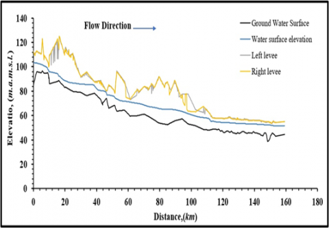
The part of Euphrates River reach is located from Haditha Dam to Ramadi Barrage, Figure 1. The length of the reach is about 160 km long. Haditha Dam and Ramadi Barrage are the main structures that control the flow of the Euphrates River within the study area. The level of the levee of the Euphrates River downstream of Hadith Dam is close to 110 m.a.m.s.l. This level of the levee gradually decreases to be 54 m.a.m.s.l. at Ramadi Barrage, the longitudinal slope of the water surface within the study reach is approximately 30 cm/km.
There is one lateral outflow along the study reach called Al-Warrar canal located at 3 km from upstream of Ramadi Barrage, this outflow protects Ramadi city from the danger of flood. The reach of the study includes five valleys that feed the Euphrates River in the rainy season. These valleys are: Haditha, Al-Baghdadi, Sahiliya, Al-Marj, and Al-Mohammadi. The maximum discharges of these valleys are listed in Table 1 [6].
Table 1. Detailed information for inflow and outflow tributaries through the reach of study [4]
|
Station Km |
Tributary |
Type |
Discharge m3/sec |
|
13+500 |
Haditha Vleys |
Inflow |
100 |
|
53+500 |
Al Baghdadi – Valleys |
Inflow |
100 |
|
95+000 |
Sahiliya Valley |
Inflow |
197 |
|
98+000 |
Al- Marj Valleys |
Inflow |
100 |
|
125+000 |
Al -Mohammadi Valleys |
Inflow |
160 |
|
160+000 |
Al -Warrar canal |
Outflow |
1000 |
Figure 1. The reach of Euphrates River from Haditha dam to Ramadi barrage
The historical records of discharge readings of the Euphrates River during the area of study including the duration of years from 1988 to 2020 were provided by National Center for Water Resources Management. These data had some missing daily discharge measurements. The data were recorded at three different stations within the Euphrates River along the area of study, these stations are located downstream of Haditha dam, Hit city, and Ramadi Barrage.
The events of the Major flood measured at varied dates were records from the previous historical information records of discharges and water levels in the four stations of measuring. The maximum flood discharge records in the Euphrates River happened within the year 1988 of 3000 m3/s [7]. In 1988, the maximum discharge of Haditha Dam was 3000 m3/s and a record water level of 167.07 m.a.m.s.l. In the same year, the gage station at Heet City records maximum discharge of 2976 m3/s with a water level of 57.88 m.a.m.s.l., where the maximum water level records in Ramadi city was 49.9 m.a.m.s.l. with a discharge of 2600 m3/s. Al-Warrar barrage recorded maximum discharge in the year 1988 about 1537 m3/s with a water level of 50.2 m.a.m.s.l. Table 2 shows Detailed information of historical records flood flowrate at the year 1988.
Table 2. Detailed information of historical records flood flowrate at the year of 1988 [7]
|
No. |
Station Name |
Discharge m3/sec |
Stage m.a.m.s.l. |
|
1 |
Haditha Dam |
3000 |
167.06 |
|
2 |
Heet |
2976 |
57.88 |
|
3 |
Ramadi |
2600 |
49.9 |
|
4 |
Al-Warrar |
1537 |
50.2 |
The widely-used software that was a product from the United States Army Corps of Engineers- Hydrologic Engineering Center’ River Analysis System, HEC-RAS 6.1, has been implemented for analyzing and simulating the unsteady and steady flow in rivers, lakes, and any open channels. This software is also too much effective in simulating water quality and sediment transport.
The steps of determining the gradually varied flow unsteady and steady-state in one dimensional model with HEC-RAS Software depend on the standard step method to get the energy grade lines and water-surface levels. It is a refined solution of open channel hydraulics principal equations, such as the flow resistance equation, the continuity equation, the energy equation, and the Froude Number. Descriptions and details of the standard step method that is applied in HEC-RAS software can be found in HEC RAS User manuals, U.S. Army Corps of Engineers, 2021 [8].
The required data to generate a model of the steady and unsteady flow in the HEC-RAS software are including complete cross-sections along the study reach, the information of discharges and water levels at the boundary, the Manning's coefficient of roughness. The details of the results will be presented in figures or tables including cross-sections details and longitudinal profiles, in addition to other components of the results.
To implement the determination of the model in an unsteady and steady-state along the 160 km of Euphrates River from Haditha Dam to Ramadi Barrage using the HEC-RAS software, the below data were applied in the model to carry out this determination. Schematic layout of Euphrates River: it was drawn in the flow direction from Haditha Dam to the upstream Ramadi Barrage at the end of the study reach. The outflow and inflow discharge locations were specified, see Figure 2. Discharge values, Table 1, at each of these locations were set so that the equation of continuity was satisfied.
Figure 2. Schematic layout of the Euphrates River Reaches
The geometry of the model includes more than a hundred cross-sections. These cross-sections include data of station along with the cross-section and elevation levels, Manning's n roughness coefficient, levees, banks, and the distances between each cross-section, the expansion and contraction of the main channel, and the right and left banks. Interpolation was implemented for cross-sections in the model of HEC RAS to get more accuracy in the determination of water level and friction losses with a maximum distance of 250 m between two sections.
The subcritical flow was applied in the model, the boundary conditions are required at the upstream and the downstream of the study reach in addition, the HEC-RAS model needs the values of the discharge upstream of the channel and the inflow of lateral reaches for the run. The boundary condition which was applied upstream of the model is the flow discharge of study reach and the known water level of the upstream of Ramadi Barrage at the downstream of the reach.
The HEC-RAS numerical software was applied to model and analyze the flow of the water along the Euphrates River from Haditha Dam to Ramadi Barrage depending on the measured data of the flow and the surveyed cross.
The model Calibration was implemented with stage measured between Haditha Dam to Ramadi Barrage at three gaging stations for the records of the last five years and the flood wave of the year 1988. A set of data was used in the calibration of the model to specify the suitable manning coefficient. This set includes different discharges graduated from the minimum to the maximum record at 3000 m3/s. Verification of the calibrated Manning's n is checked by using one set of data that is given the minimum RMSE. The simulation aims at predicting the maximum Discharge that can safely pass along the Euphrates River from Haditha Dam to Ramadi barrage with the current condition, under the surveyed cross-sections, and checking the ability of the reach to pass 3000 m3/s, which is the maximum discharge recorded in the downstream Hadith Dam at 1988. Later, applying modification for the critical cross-sections into the trapezoidal section if needed to pass discharge of 4000 m3/s which is the maximum discharge predicted in the (SWLRI) [9]. Different scenarios were carried out in the model by raising the flowrate at upstream of the river in the study area to predict the current capacity for the Euphrates River along the reach from Hadith Dam to Ramadi Barrage, and critical flowrate that may lead to cause a flood. Each scenario runs with two cases, the first case of the run is the flowrate of the Hadith Dam with maximum lateral inflow and the other run with no lateral inflow. The checking of the discharge that can pass safely from Hadith Dam to Ramadi barrage is computed to minimum freeboard getting from the runs in the available surveyed cross-sections. It is suggested that the discharge passes safely within the study reach when the minimum freeboard is more than 0.5 m. After determining the current capacity and specifying the sections that cause contraction to the flow, modifications are carried out in the required sections to pass discharge of 4000 m3/s (SWLRI) [9], which represents the maximum predicted discharge for 500 years of the return period.
7.1 Calibration and verification
With many simulations of runs in HEC-RAS software, it has appeared that the differences between the measured and observed level of water can be declined if the study reach is divided into two divisions, each part has a different roughness coefficient. The first part is extended from Haditha Dam to Heet City, and the second part is extended from Heet to Ramadi Barrage.
Table 3 displays the computed values of (RMSE) by using various values of Roughness coefficient (n) throughout the calibration process straight the reach between Haditha Dam and Al-Ramadi Barrage. The process was operated by using the data with a discharge varied from 200 m3/sec to 1200 m3/sec flowed from Haditha Dam and for the data records along the study reach for the last five years at Heet gage Station. Many trials were done by applying the value of (0.022, 0.024, 0.026, 0.028, 0.030) for the main channel and a constant value of 0.030 for the flood plain for the part of the reach from Haditha Dam to Heet City and the values of (0.020, 0.022, 0.024, 0.026, 0.028) for the part from Heet – Ramadi Barrage with 0.030 at flood plain , The minimum value of RMSE was 0.267, it was gained when using Roughness coefficient (n) 0.026, 0.024 for the reach (Haditha Dam – Hit) and (Hit – Al Ramadi Barrage), respectively. The flood plain of the whole reach under study was 0.030.
Table 3. RMSE results of calibration test
|
Case No. |
Part of the Channel |
Manning n |
RMSE |
|
|
Haditha Dam – Hit |
Hit – Al Ramadi Barrage |
|||
|
C1 |
Main |
0.022 |
0.02 |
0.367 |
|
Flood Plain |
0.030 |
|||
|
C2 |
Main |
0.024 |
0.022 |
0.297 |
|
Flood Plain |
0.030 |
|||
|
C3 |
Main |
0.026 |
0.024 |
0.267 |
|
Flood Plain |
0.030 |
|||
|
C4 |
Main |
0.028 |
0.026 |
0.308 |
|
Flood Plain |
0.030 |
|||
|
C5 |
Main |
0.030 |
0.028 |
0.390 |
|
Flood Plain |
0.030 |
|||
The calibrated value of the roughness coefficient was verified using some discharges that were recorded in the Heet Gage station as shown in Table 4, it appears that the water surface profile for the verification process. The results showed good coincidence between the records data with the measured in the model in applying manning (n) as in (C3) with RMSE of 0.267.
Table 4. Comparison among the records and the modeled water levels between verification of the calibrated Roughness coefficients
|
Calibration Case No. |
Discharge (m3/s) |
Water surface elevation, m.a.m.s.l. |
|
|
Records |
Model |
||
|
C3 |
200 |
52.15 |
52.27 |
|
375 |
53.02 |
53.08 |
|
|
480 |
53.23 |
53.47 |
|
|
600 |
53.72 |
53.92 |
|
|
800 |
54.88 |
54.49 |
|
|
3000 |
57.88 |
58.33 |
|
7.2 The capacity results of the study reach
Predicting the flowrate capacity of Euphrates River by increasing the assumed flowrate at Haditha Dam with different scenarios until reaching the ultimate discharges that probably caused the flood. It was established that the flowrate below 3000 m3/sec is passed by the main channel reach. At a flowrate of more than 3000 m3/sec, the elevation of the water surface at various locations extends to the flood plain. The outcome obtained two scenarios of lateral outflow and inflow. The first scenario is simulated that all lateral inflows were supposed to be as zero, and lateral outflow. The second scenario presented that discharge of 3000 m3/s was flow from Haditha Dam and lateral inflow with outflow as shown in. Figure 3 and Figure 4 display the elevation of the water surface for the two satiations at a flowrate of 3000 m3/sec, all water elevations at these satiations are still 1m less than the left and right levees elevations of Euphrates River reach. In the first situation.
Figure 3. Water surface profile at flowrate of 3000 m3/s, first scenario
Figure 4. Water surface profile at flowrate of 3000 m3/sec, second scenario
The model runs by getting the recorded flood flowrate of 4000 m3/sec at Haditha Dam. The runs were conducted by assuming other two scenarios of lateral outflow and inflow.
Figures 5 and 6 display two scenarios of water elevation along the river reach at a flowrate of 4000 m3/s. It is obvious that the reach of the Euphrates River will not accommodate the overflow flowrate at a current situation of the cross-section. Water surface elevation with lateral outflow (The third scenario) is higher than river reach levee, and below the water surface elevation with lateral inflow and outflow (the fourth scenario) which indicates the variation of river capacity and flow reduction is due to the large quantities of sediment.
Twenty cross-sections were specified upstream of Ramadi Barrage causing choking to the discharge within the reach of Euphrates River from Haditha Dam to Ramadi Barrage. These cross-sections, which represented the 40 Kilometers upstream Ramadi Barrage, were reshaped to trapezoidal and expanded [10]. Figure 7 shows one modified cross-section which is located 2 Kilometers upstream of Ramadi Barrage.
The results of the model run after modification the cross-sections appeared that the levels of the water within the study reach are decreased by about 1 m. Therefore, the modification of the cross-sections achieved the required lowering in water level and increased the capacity of the reach [11].
Figure 5. Water surface profile at a flowrate of 4000 m3/s, third scenario
Figure 6. Water surface profile at a flowrate of 4000 m3/s, fourth scenario
A discharge of 4000 m3/s could be safely passed from Haditha Dam to Ramadi Barrage without any lateral inflow after modification of the previously specified locations, and 4000 m3/s with lateral inflow from the valleys. Figures 8 and 9 show the levels of the water within the study reach of the Euphrates River after modifying the cross-sections for a discharge of 4000 m3/s without any lateral inflow, and 4000 m3/s with lateral inflow, respectively. All water levels along the reach are kept at 1m below the level of levees.
Figure 7. Modified cross-section at 2 Kilometers upstream Ramadi Barrage
Figure 8. Water surface profile within the Euphrates reaches after modifying 40 Kilometers chocking locations upstream Ramadi Barrage for a discharge of 4000 m3/s, without any lateral inflow
Figure 9. Water surface profile within the Euphrates reaches after modifying 40 Kilometers chocking locations upstream Ramadi Barrage for a discharge of 4000 m3/s, without lateral inflow and outflow
The study showed that the current conditions of Euphrates River from Haditha Dam to Ramadi Barrage can pass safely discharge of 3000 m3/s in case there is lateral inflow and outflow or there is no lateral inflow from valleys. This discharge represents the same discharge that flows in the study reached in the year 1988.
- The reach of the study cannot pass discharge of 4000 m3/s which is the maximum discharge predicted in the SWLRI, 2014 [9]. Therefore. The chocking cross-sections specified to reshape it to increase the capacity of the river within the study reach.
- The results of the model showed that the modification of the last 40 km of the study reach led to lowering the water levels in the study reach to a safe distance from the river levees for about 1m.
[1] Abdullah, M., Al-Ansari, N. (2021). Irrigation projects in Iraq. Journal of Earth Sciences and Geotechnical Engineering, 11(2): 35-160. https://doi.org/10.47260/jesge/1123
[2] Al-Zaidy, H.S.A., Al-Thamiry, H.A.K. (2020). Prediction capacity of Euphrates river at Assamawa City. Journal of Engineering, 26(4): 111-122. https://doi.org/10.31026/j.eng.2020.04.08
[3] Al-Kazwini, M.J., Al-Suhaily, R.H., Al-hdawi, S.A. (2011). Numerical modeling of flood wave behavior with meandering effects (Euphrates River, Haditha-Hit). Eng. & Tech. Journal, 29(7).
[4] Al Khuzaiea, H.M.A., Awad, A.M., Abbas, M.F. (2018). A hydraulic model for identification of surface friction coefficient for Euphrates River within Al Muthanna Governorate, Iraq. Al-Muthana Journal of Engineering and Technology, 6(2): 160-168. http://dx.doi.org/10.18081/mjet/2018-6/160-168
[5] Shayea, A.G., Al Thamiry, H.A. (2019). Effect of tail regulators on Euphrates River Flood Capacity at Al Nassiriyah City. Journal of Engineering, 26(1): 43-54. https://doi.org/10.31026/j.eng.2020.01.05
[6] Farhan, A.M. (2020). Estimation of surface runoff in arid regions by using soil and water assessment tool (SWAT) (Case study: A part of the Iraqi Western Desert). Master Thesis, University of Baghdad, Iraq.
[7] MoWR, Ministry of Water Resources. (2021). The Recorded Discharges and Water Level, Unpublished Documents.
[8] US Army Corps of Engineers. (2021). HEC-RAS, User Manual. Hydrologic Engineering Center, Version 6.1. USA.
[9] Ministry of Water Resources. (2014). The Study of Strategy for Water and Land Resources in Iraq (SWLRI), Unpublished Document, Baghdad, Iraq.
[10] Abbas, M.S., Azzubaidi, R.Z. (2020). Current and modified flood discharge capacity of a reach of Tigris River between Kut and Amarah Barrages. Journal of Engineering, 26(2): 129-143. https://doi.org/10.31026/j.eng.2020.02.10
[11] Mustafa, A.S., Sulaiman, S.O., Al_Alwani, K.M. (2017). Application of HEC-RAS model to predict sediment transport for Euphrates river from Haditha to heet 2016. Al-Nahrain Journal for Engineering Sciences, 20(3): 570-577.