Thongtep Sirisoda*![]() | Rawinan Loymek
| Rawinan Loymek![]()
© 2023 IIETA. This article is published by IIETA and is licensed under the CC BY 4.0 license (http://creativecommons.org/licenses/by/4.0/).
OPEN ACCESS
To survey and map Thung Luang Rangsit's cultural heritage was one of the study's primary goals. The research team's goal is to examine, gather, and evaluate data on the possibilities of cultural heritage tourism. Using data, information, and pertinent documents, as well as observations, surveys, and group discussions with community members and representatives from relevant organizations. The research results revealed the cultural heritage map of Thung Luang Rangsit, Pathum Thani Province. There are outstanding tourist attractions in art, products, food, and architecture. The potential of such tourism resources is in line with preserving the city and the historic district. It has a connection with history, reflects culture and beliefs, and reflects the people's way of life in the area. However, the concept of tourism news development standards still needs public relations. To construct a trail or tourism programs that connect tourism to other old town attractions, studies of ancient architecture, adhering to the idea of conserving the city and neighborhood history, and building a brand (branding) of Pathum Thani are suggested further research topics.
cultural heritage map, Pathum Thani, temple
Cultural Route of World Heritage Sites UNESCO in Southeast Asia retains its identity. Every place has a fascinating history worth learning and exploring a World Heritage site [1]. Experience the grandeur, beauty, history, and culture. Near Ayutthaya, Pathum Thani was once Southeast Asia's most prosperous and wealthy capital. It is a substantial commercial and economic center. Many important historical sites include mosques, churches, shrines, and temples. All of which show evidence of the history and glorious civilization of Pathum Thani in the past. Pathum Thani Province has a traditional ethnic group consisting of the original Thai people living in the area and the Mon people who migrated. According to historical evidence, Mon people immigrated to Thailand during the Ayutthaya period. During the reign of King Maha Thammaracha, 1569 to 1590, later under the control of King Narai the Great Around the year 1659, he ordered the Mon people to settle in Sam Khok, a small town located along the Chao Phraya River. Samkhok City, in the past, has become a reflection of Pathum Thani Province. Therefore, the culture of the Pathum Thani people is diverse. Both the culture of the traditional Thai people living in the area. And the culture of the Mon people who immigrated, Including the cultural mix of both races [2]. The Mon people migrated to Burma in 1774, known as Krua Phraya Jeng or Old Mon with Phraya Jeng and Phraya Klang Muang, during the Thonburi period in the realm of King Taksin the Great. Approximately 30,000 Mon people fled from Burma to rely on King Taksin the Great, along with the Mon people, who the Burmese forcibly abducted after the second fall of the capital. His Majesty set up houses in Samkhok City again by calling the Mon people who immigrated this time "Old Mon" [3] during the Rattanakosin period. The reign of King Rama II, 1815, was the largest migration of the Mon community. Who called themselves "Mai Mon," emigrated from Burma to listen to King Rama 2. He graciously Set up houses in Sam Khok City, Nonthaburi City, and Nakhon Khuean Khan City [4]. They found evidence, whether it is a temple, a stove, a jar, an Ang Tum Sam Khok, a rice cooker, a Mon brick, and pottery. It also includes activities of lifestyle. The Mon people's customs came to Thailand from Burma, where the king protected them for centuries. With permission to settle in Pathum Thani Province. As a result, Pathum Thani province has activities related to the Mon, such as cooking Kao-Chae and stirring Khao Thip. In addition, the tourist attractions of Pathum Thani also have religious places and temples. Showing traces of local cultural heritage reflects the Mon people's history and way of life [5].
The research team realized the importance of this. Because of this, spreading the word about the 100-year-old temple in Thung Luang Rangsit, Pathum Thani, will serve as a mechanism to preserve the city's traditional community and cultural legacy, all while allowing for sustainable urban development [6]. The project's goal and focus are to examine, inventory, and identify the structures in conventional residential areas. They define the position, coordinates, architectural style, and historical significance of the source or region. Activities that are economically and socially beneficial to the city's cultural heritage. Through the participation of various local groups, bringing information to systematize cultural heritage sites, including recording as a document that the local and relevant agencies can reference. Both in urban planning, Community and social development Management of conservation and restoration of Pathum Thani city. as well as preliminary risk assessments of cultural heritage sites. Primary suggestions for conservation Guidelines for the application of architectural science in the study of Thung Luang Rangsit history.
To explore the cultural heritage tourism map in the 100-year-old temple architecture in Thung Luang Rangsit, Pathum Thani Province.
3.1 Scope of study
A tangible cultural legacy includes historical, cultural, and artistic artifacts. Buildings are often the most visible and enduring symbols of a community's past and culture. Here are some tangible cultural heritage buildings. Faith: Temples have cultural and historical importance. They may have unique architecture, religious artwork, and artifacts that reflect the society that built them.
3.2 Area boundary
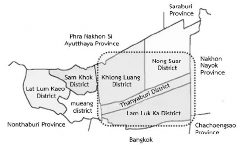
Thung Luang Rangsit area Pathum Thani Province, Thailand, which has four districts consisting of Khlong Luang District, Nong Suea District, Thanyaburi District, and Lam Luk Ka District. A huge field. Between the Chao Phraya and Bang Pakong rivers. Saraburi connects to Nakhon Nayok in the east and Phra Nakhon Si Ayutthaya in the north. Bangkok borders the south. The west borders Nonthaburi Province (Figure 1) Mon, Thai, Chinese, Laos, and Malay Muslims moved there after digging the canal. Rice, rivers, and multiculturalism abound.
Figure 1. Thung Luang Rangsit Cultural Area, Pathum Thani Province
This research was qualitative. To gather information, we conducted a survey. Thung Luang Rangsit is a temple in Pathum Thani that has existed for a century. Settlements with vernacular architecture and Architectural styles of significant structures that contribute to community well-being and way of life should be included in a cultural heritage map to preserve the region's rich architectural history and the traditions that have kept it alive long. Collect information about the area's origins, evolution, and the growth of its settlements. For sustainable tourism development to support tourism, there are two research methods in this research as follows. 1. Gather primary data sources, including research area surveys. Characteristics of the physical environment, current architecture of the area of Thung Luang, Rangsit, and taking pictures of primary 2. Collecting secondary sources, i.e., studying relevant research History, background, way of life and temple architecture, vernacular architecture settlement, Architectural styles of valuable buildings that are related to lifestyle community well-being, Evolution and settlement development of Thung Luang Rangsit community area.
4.1 Research instruments
4.1.1 Logbook
For taking notes and sketching compass and a sketch board. The research team has used a laser distance measurement device to draw lines on architectural drawings, allowing them to record various data points. For use in data analysis.
4.1.2 Digital cameras
To record pictures from the survey area [7].
4.2 Data collection
4.2.1 Study and review the literature
Relevant research information, community history research, Architecture, and art, collect data from historical documents, official documents, textbooks, books, research articles, and other related articles. Including the map.
4.2.2 Collect data from field surveys
By surveying the area along the route surrounding Thung Luang Rangsit, which has four districts consisting of Khlong Luang District, Nong Suea District, Thanyaburi District, and Lam Luk Ka District, the location, physical characteristics, and architectural features of the area can be determined. Temples, churches, mosques, and shrines that date back more than a century and have 100-year-old architecture are still in existence today.
4.3 Data analysis
Use content analysis (Content Analysis) by collecting data from surveys. Check the information for content accuracy. And analyze the data with information from other sources, such as relevant papers, past research, and content analysis summaries. And photographs gathered to organize and perform.
The research of historical archives has revealed that Thung Luang Rangsit cultural heritage survey findings in Pathum Thani Province's Khlong Luang, Lam Luk Ka, Nong Suea, and Thanyaburi districts. This research examined the tourist map of Thung Luang Rangsit's ancient temples, many of which are over a century old. Pathum Thani Province The details are as follows.
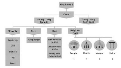
The study and survey about Thung Luang Rangsit’s cultural heritage found that the Thung Luang Rangsit area of Pathum Thani Province has various cultural resources. Since the reign of King Rama V, a canal has become the subject of digging. Consists of Thung Luang Rangsit and Thung Luang Saen Saeb, causing the Thung Luang Rangsit area to create a variety of cultures, including ethnicities, rivers, rice, and religious places as follows: (Figure 2).
Figure 2. Map showing Thung Luang Rangsit Cultural Heritage Pathumthani Province
Places of worship in Khlong Luang, Thanyaburi, Nong Suea, and Lam Luk Ka, all of which are in Pathum Thani Province. Spiritual and religious sites serve as symbols of the coexistence of many faiths and beliefs. In the same context linked together as multicultural, including temples, churches, mosques, and shrines. Fourteen temples (from an analysis of 45 temples) [8], one church, one mosque, and eight shrines have architectural features that are over 100 years old and still exist today. (Figure 3).
Figure 3. Religious sites in Thung Luang Rangsit area, Pathum Thani Province
Table 1. Old temple architecture, 100 years old or older in Thung Luang Rangsit, Pathum Thani Province
|
No. |
Temple name |
Subdistrict |
District |
|
1 |
Sawang phop temple |
Khlong Si |
Khlong Luang |
|
2 |
Sirichandraram temple |
Khlong Ha |
Khlong Luang |
|
3 |
U Khao temple |
Klong Chet |
Khlong Luang |
|
4 |
Phoem Than temple |
Khlong Si |
Khlong Luang |
|
5 |
Tawanruang temple |
Khlong Si |
Khlong Luang |
|
6 |
Phalahan temple |
Khlong Hok |
Khlong Luang |
|
7 |
Klangklongsam temple |
Khlong Sam |
Khlong Luang |
|
8 |
Wan Boon temple |
Khlong Hok |
Khlong Luang |
|
9 |
Bang Khan temple |
Khlong Nueng |
Khlong Luang |
|
10 |
Kla Cha-um temple |
Khlong Song |
Khlong Luang |
|
11 |
Sangsan temple |
Prachathipat |
Thanyaburi |
|
12 |
Khienkhate temple |
Bueng Yitho |
Thanyaburi |
|
13 |
Muljindaram temple |
Bueng Yitho |
Thanyaburi |
|
14 |
Nabun temple |
Rangsit |
Thanyaburi |
|
15 |
Ayikaram temple |
Lam Phak Kut |
Thanyaburi |
|
16 |
Sra Bua temple |
Bueng Nam Rak |
Thanyaburi |
|
17 |
Sangmani temple |
Bueng Ba |
Nong Suea |
|
18 |
Bueng Baprabhasawat temple |
Bueng Ba |
Nong Suea |
|
19 |
Srisamosorn temple |
Bueng Bon |
Nong Suea |
|
20 |
Puangkaew temple |
Bueng Bon |
Nong Suea |
|
21 |
Bueng Bon temple |
Bueng Bon |
Nong Suea |
|
22 |
Sukpuntarigaram temple |
Bueng Cham O |
Nong Suea |
|
23 |
Srikankanang temple |
Bueng Cham O |
Nong Suea |
|
24 |
Ployfon temple |
Nong Sam Wang |
Nong Suea |
|
25 |
Posopholchareon temple |
Khu Khot |
Lam Luk Ka |
|
26 |
Latsnun temple |
Khu Khot |
Lam Luk Ka |
|
27 |
Saimai temple |
Khu Khot |
Lam Luk Ka |
|
28 |
Klong Chan temple |
Lat Sawai |
Lam Luk Ka |
|
29 |
Klangklongsi temple |
Lat Sawai |
Lam Luk Ka |
|
30 |
Prachumrat temple |
Bueng Kham Phroi |
Lam Luk Ka |
|
31 |
Panchayigavas temple |
Bueng Kham Phroi |
Lam Luk Ka |
|
32 |
Ratsattharam temple |
Bueng Kham Phroi |
Lam Luk Ka |
|
33 |
Nangal chantri temple |
Bueng Kham Phroi |
Lam Luk Ka |
|
34 |
Janglamhin temple |
Bueng Kham Phroi |
Lam Luk Ka |
|
35 |
Thanyaphon temple |
Lam Luk Ka |
Lam Luk Ka |
|
36 |
Nithes Rat Pradit temple |
Lam Luk Ka |
Lam Luk Ka |
|
37 |
Lanna temple |
Lam Luk Ka |
Lam Luk Ka |
|
38 |
Don Yai temple |
Lam Luk Ka |
Lam Luk Ka |
|
39 |
Samuharat Bumrung temple |
Lam Luk Ka |
Lam Luk Ka |
|
40 |
Thotsathisaram temple |
Bueng Thong Lang |
Lam Luk Ka |
|
41 |
Tamlaytong temple |
Bueng Thong Lang |
Lam Luk Ka |
|
42 |
Pirunsart temple |
Bueng Thong Lang |
Lam Luk Ka |
|
43 |
Mongkolrat temple |
Lam Sai |
Lam Luk Ka |
|
44 |
ChaiMangalaram temple |
Lam Sai |
Lam Luk Ka |
|
45 |
Phuet Udom temple |
Phuet Udom |
Lam Luk Ka |
The Table 1 collects data on temple architecture aged over 100 years in Thung Luang Rangsit. Pathum Thani Province above the research team visited the area to explore the old temple architecture that still exists today. To assess the value of potential development as follows:
Table 2. Old temple type architecture in the Thung Luang Rangsit Cultural Heritage Area
|
District |
All Temples |
100-year-old temple upwards |
The temple has an old architecture today |
|
Khlong Luang |
21 |
10 |
4 |
|
Thanyaburi |
13 |
6 |
3 |
|
Nong Suea |
23 |
8 |
1 |
|
Lam Luk Ka |
31 |
21 |
6 |
|
Total |
88 |
45 |
14 |
From the Table 2, the research team has taken 14 temples with old architecture that still exist today to make a cultural heritage tourism map of temple architecture. (Figure 4). Because the size and shape of a building are independent of the distance to the point of view, the research team in Thung Luang Rangsit Pathum Thani Province has chosen techniques and methods to display landmarks and points of interest using multiple perspectives to present information. These include an orthographic view of the ground plane area and three-dimensional (Oblique and perspective projections) of buildings. Also, perceive the building's distinctive features stand out. This map is preferable to one that does not display any buildings or shows their exteriors. The latter needs to convey vital information about the surrounding area, making it more challenging for map users to learn and retain relevant landmarks. Some maps, for instance, make do with sparse picture data.
Figure 4. A map showing the location of temples that are 100 years old or older. 14 temples
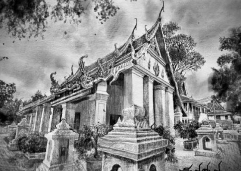
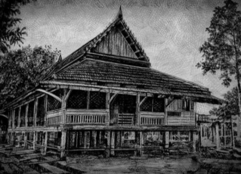
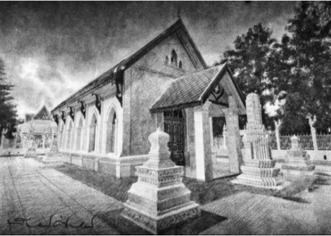
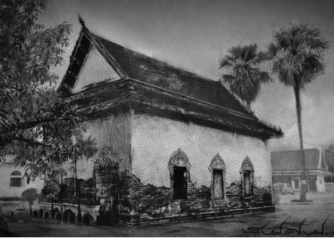
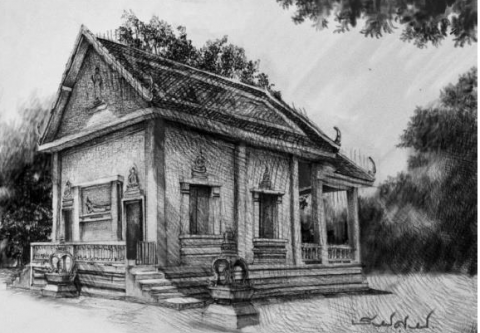
Physical and cultural heritage survey results of Thung Luang Rangsit Cultural Heritage Area Pathum Thani old city found that its historical importance and natural value resulted in the development of the management of the original landscape to make proper use of the land. In addition, the researcher considered the temple's historical and cultural significance. Before preparing an itinerary, some temples may have religious or spiritual significance for the community [9]. Incorporating these temples into the cultural map may necessitate consideration and consultation with the local community and gathering information by sketching a recording line such as Klachaum temple. (Figure 5), Khienkhate temple (Figure 6), Don Yai temple (Figure 7), Chaeng Lam Hin temple (Figure 8), Hatthasarn Kaset temple (Figure 9), Khlong Chan temple (Figure 10), Muljindaram Temple (Figure 11) and Phoi Fon temple (Figure 12) The potential of ecosystems and other natural resources demonstrates this. It shows the way of life, residence, and important economics of Pathum Thani from the past to the present. The cultural heritage of temple architecture is considered a city that connects places, activities, and history [10]. It can be observed from the community's way of life that it still has religious beliefs and different practices. The region's many different populations live together in shared settlements. In a multiethnic society, people of different backgrounds can use the space and "live together" without communicating. The Burra Charter's valuation methodology found that the cultural heritage area Thung Luang Rangsit Cultural Heritage Area Pathum Thani has three resource potentials: 1) architectural tourism potential, 2) historical tourism potential, and 3) cultural and lifestyle tourism potential.
Figure 5. Line drawings from architectural surveys Klachaum temple Khlong Luang District, Pathum Thani Province
Figure 6. Line drawings from architectural surveys Khienkhate temple, Lam Luk Ka District, Pathum Thani Province
Figure 7. Line drawings from architectural surveys Don Yai temple, Lam Luk Ka District, Pathum Thani Province
Figure 8. Line drawings from architectural surveys Chaeng Lam Hin temple, Lam Luk Ka District, Pathum Thani Province
Figure 9. Line drawings from architectural surveys Hatthasarn Kaset temple, Khlong Luang District, Pathum Thani Province
Figure 10. Line drawings from architectural surveys Khlong Chan temple, Thanyaburi District, Pathum Thani Province
Figure 11. Line drawings from architectural surveys Muljindaram Temple, Thanyaburi District, Pathum Thani Province
Figure 12. Line drawings from architectural surveys Phoi Fon temple, Nong Suar District, Pathum Thani Province
According to a study of the potential of tourism resources at cultural sites in the Thung Luang Rangsit Cultural Heritage Area, cultural sites have tourism resource potential. This aligns with the Burra Charter's valuation methodology and is a tourism asset, particularly in the old town area of Pathum Thani. There are architecturally remarkable tourist destinations. It connects to history and reflects the local population's culture and way of life [11]. Guideline proposal Potential tourism development of such assets by preserving the city and the historic district, structures, and other architectural works are improved and modified. Its construction should be kept. The building's singularity holds its historical and cultural significance. Using the existing environment and urban landscape as a foundation, try repurposing historic structures to promote tourism. Specifically, avoid demolishing buildings.
According to Grabler et al. [12] the first challenge in map design is determining the tourism route and the significance of various tourist-attractive elements, such as architecture and history. The tourism industry is modest, consisting primarily of visitors. Frequently walk alongside the city's public transportation system. Therefore, the map must include landmarks and objects of interest to enable their identification. By presenting all three types of milestones, as noted by Deakin [13] and Michon and Denis [14] cognitive landmarks help visitors understand the nature of places or reflect their interests, whereas visual and structural landmarks facilitate navigation.
According to surveys of cultural heritage, temple architecture contains cultural heritage areas. In the province of Thung Luang Rangsit Pathum Thani, it was discovered that historical structures and ancient sites had been preserved to the present day particularly temple-style architectural designs. The survey of architectural buildings within the temple determined that there were structures older than 100 years and that only 14 designs could be considered for further development. Based on the historical significance and numerous activities, most are situated in the Khlong Rangsit region and on roads. Because there is currently a road that travels parallel to Khlong Rangsit, it is possible to imagine the old city of Thung Luang Rangsit in the past. As cultural heritage is valuable, valuing cultural heritage is a crucial stage in the process of conservation to prioritize and be used for consideration and selection of appropriate conservation and management methods for maximum benefit to society, which must consider the cultural heritage that has outstanding value in any aspect such as aesthetics, archaeology, history, academics, or social factors, to plan for preservation the most significant value while retaining significance in the following areas as applicable. By receiving assistance from government agencies and the private sector, such as the chapel, the architectural style of the past has been passed on to the present, which discovered both Thai and Western architecture. Some locations, such as the Ubosot of Wat Khlong Chan, have preserved the architecture to remain in its original condition and have degraded over time. Some of them have undergone extensive renovations. Don't forget to have historically significant buildings. 100th anniversary of making only 14 buildings [15].
The cultural map created by Thung Luang Rangsit exemplifies how the concept of cultural routes has led to the identification of new cultural heritage protection directions, methodologies, and policies. Thung Luang Rangsit is a Thai village designated as a cultural route due to its historical significance as a trading hub between Thailand and its neighbors [16].
Thung Luang Rangsit's cultural map depicts tangible and intangible cultural heritage resources, including historic structures, temples, traditional crafts, and local customs and traditions. The map is an instrument for promoting the village's cultural heritage and tourism potential and preserving its cultural resources.
This strategy for protecting cultural heritage recognizes the significance of inheritance beyond its archaeological and material worth. It recognizes that cultural heritage encompasses not only physical structures and objects but also the intangible aspects of culture that define a community's identity and way of life.
As a result, identifying and protecting cultural routes and creating cultural maps can help raise awareness of the value of cultural heritage and encourage its appreciation and preservation. These strategies can also contribute to the sustainable development of communities and bolster local economies by attracting cultural visitors interested in experiencing and learning about different cultures.
[1] Al-Jaberi, Z.A., Hasan, S.A. (2022). Reviving the cultural route and its role in the sustainability of historical areas - Kerbala as a case study. International Journal of Sustainable Development and Planning, 17(6): 1737-1746. https://doi.org/10.18280/ijsdp.170607
[2] Thitiwattanarat, S. (2009). A study of the role and activities of Pi Pathan Mon music in society and culture in Pathum Thani Province. Rangsit Journal of Music, 4(2): 40.
[3] Pannathi, T. (1981). Pathumthani in the past. Jutharat Printing House, Bangkok, Thailand.
[4] Hom Yok, S. (1981). The legend of Mon Muang Pathum Thani. Rangsit Music Journal, 1(2): 35.
[5] Wongsupthai, V. (2012). Pathum Raman thani threw the king's name, Thai Raman reminisced about the Mon people. PathumThani Provincial Administrative Organization, Pathum Thani, Thailand.
[6] Dayoub, B., Yang, P.F., Dayoub, A., Omran, S., Li, H. (2020). The role of cultural routes in sustainable tourism development: A case study of Syria’s Spiritual Route. International Journal of Sustainable Development and Planning, 15(6): 865-874. https://doi.org/10.18280/ijsdp.150610
[7] Hindersah, H., Agustina, I.H., Chofyan, I. (2021). The spiritual path of pilgrimage tourism for sustainable development: Case-Desa Astana-Cirebon, Indonesia. International Journal of Sustainable Development and Planning, 16(4): 751-758. https://doi.org/10.18280/ijsdp.160415
[8] Yang, D., Zhang, D., Qu, B. (2016). Participatory cultural mapping based on collective behavior data in location-based social networks. ACM Transactions on Intelligent Systems and Technology (TIST), 7(3): 1-23.
[9] Gianfrate, V., Djalali, A., Turillazzi, B., Boulanger, S.O.M., Massari, M. (2020). Research-action-research towards a circular urban system for multi-level regeneration in historical cities: The case of Bologna. International Journal of Design & Nature and Ecodynamics, 15(1): 5-11. https://doi.org/10.18280/ijdne.150102
[10] Allawi, A.H. (2022). Towards smart trends for tourism development and its role in the place sustainability- Karbala region, a case study. International Journal of Sustainable Development and Planning, 17(3): 931-939. https://doi.org/10.18280/ijsdp.170323
[11] Alzouby, A.M., Attia, A.S. (2022). Reviving the traditional house architecture in Irbid city, Jordan. International Journal of Sustainable Development and Planning, 17(1): 147-155. https://doi.org/10.18280/ijsdp.170114
[12] Grabler, F., Agrawala, M., Sumner, W, R., Pauly, M. (2008). Automatic generation of tourist maps. ACM Transactions on Graphics, 27(3): 1-11. https://doi.org/10.1145/1360612.1360699
[13] Deakin, A.K. (1996). Landmarks as navigational aids on street maps. Cartography and Geographic Information Systems, 23(1): 21-36.
[14] Michon, P.E., Denis, M. (2001). When and why are visual landmarks used in giving directions?. Proceedings of International Conference on Spatial Information Theory, Berlin, Heidelberg, Germany, pp. 293-305.
[15] Fafurida, F., Daerobi, A., Riyanto, G. (2022). Implementation model of community based tourism on rural tourism. International Journal of Sustainable Development and Planning, 17(2): 507-512. https://doi.org/10.18280/ijsdp.170215
[16] Poch, E., Llano, U., de la Fuente, A. (2020). Traditional cultural heritage vs film sceneries: evaluating the degree of sustainability of cultural landscapes. International Journal of Design & Nature and Ecodynamics, 15(5): 621-630. http://dx.doi.org/10.18280/ijdne.150502