Sara Mahmood Al-Jawari*![]() | Falah M. Hadi
| Falah M. Hadi![]() | Mustafa Abduljalil Ebraheem
| Mustafa Abduljalil Ebraheem![]() | Moheb Kamel Al-Rawe
| Moheb Kamel Al-Rawe![]()
© 2025 The authors. This article is published by IIETA and is licensed under the CC BY 4.0 license (http://creativecommons.org/licenses/by/4.0/).
OPEN ACCESS
A major issue in urban areas is the expansion of slums coupled with poor city planning. One of the areas encountering these challenges is Hit City, where the economy, society, services, environment, and other domains are significantly impacted. The research intends to utilize the AHP method as it serves as an excellent approach for selecting the best strategies to tackle slums. The present research used a clear and detailed method to look at several important factors, such as urban data, services and infrastructure, the economy, the environment, ownership, and how well it fits with the main plan, roads, and the costs of solutions. This helped check if the decisions were consistent and led to a final ranking of options: development, regulation, and removal. We assessed these criteria on a scale from 1 to 10, evaluating their relative comparisons and significance. The research results showed that these aspects are different from each other. The Al-Maamoura neighborhood got the highest score of 5. 92, and the chosen solution to manage it was the best one. In the Al-Farouq neighborhood, the analysis found major problems with the buildings and their design. As a result, it was proposed that all items be cleared away and individuals relocated to a different location. The study suggested 5 areas to improve, 6 areas to set rules for, and 1 area to get rid of.
AHP methodology, slums, urban sustainability, urban management, decision making, hit, Iraq
The issue of informal settlements and encroachments is one of the most prominent challenges facing infrastructure development projects and the provision of decent housing for every citizen [1, 2]. One of the most significant negative impacts of informal settlements is the weakness of infrastructure and the absence of proper urban planning [3, 4]. Residents of these areas suffer from a lack of access to sanitation facilities, clean water sources, electricity, poor ventilation, and other services due to the unnatural living conditions in their areas, as well as the lack of basic services [5, 6]. Consequently, these areas suffer from environmental pollution, deteriorating health conditions, and widespread social problems such as crime and unemployment [7].
Informal settlement development policies have diversified in developing countries to address the informal housing crisis. The removal-upgrading-regulation approach is one such policy [8, 9].
The Analytical Hierarchy Process (AHP) is an effective tool for multi-criteria analysis to support decision-making [10]. It provides a decision-making procedure that presents the problem through a hierarchical structure. Based on the qualitative judgment of experts and users, it relies on pairwise comparisons to prioritize alternatives and provide an overall ranking [11, 12].
Alam and Mondal [12] discuss the sanitation issue in Khulna City, which is considered the largest city in Bangladesh, with 8.14% of its total area being slums and suffering from poor sanitation facilities. Even the efforts made by the government and NGOs to improve this service do not meet the minimum requirements. This research aimed to evaluate the quality of urban sanitation services in railway slums using the Customer Satisfaction Index (CSI) to assess the gap between the reality and expectations of railway slum residents. An analytical hierarchy was used, and it was found that the satisfaction level is average. Through this methodology, the research was able to provide a clear understanding of residents' satisfaction with sanitation services, which would lead to improvements in the performance of municipalities in providing their services [13].
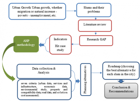
Dewi et al. [13], in their research, addressed the environmental and sanitation problems caused by slums. The Tangerang Municipality is planning to relocate slums in the Sisadan Riverside area and offers several alternatives to solve this problem: either relocating residents to housing in another area, maintaining their locations on the riverbank but offering alternative, simple apartments, or not relocating them and providing them with the services they need. Several criteria were established for this, including cost, technology, and acceptable environmental impact. The AHP was used to help make the best decision [14]. Figure 1 represents the research methodology.
Figure 1. Research methodology
Salari and Madrazo [14] use desk research to identify the causes and characteristics of slums, as well as the Analytical Network Process (ANP) to analyze the relationship between the SDGs and slum characteristics. A case study using the Slum Upgrading Program (SUP) utilizes cities such as Medellín, Colombia. The results of the ANP methodology demonstrate the SDGs most closely related to slum sustainability, which planners and decision-makers should consider in future planning. This is particularly true given that most cities face similar challenges, including the massive expansion of slums, a result of various factors that vary from city to city worldwide. These growing numbers of slums lead to several problems, including deteriorating air quality and poor and inadequate services. In fact, slums pose a significant obstacle to achieving the SDGs due to the lack of access to safe drinking water, inadequate sanitation, and the lack of services provided by cities. Currently, due to the large number of slum dwellers and the resulting social, economic, and environmental problems, slums remain a persistent problem worldwide [15].
Previous studies were reviewed to identify the research gap, which can be summarized as follows:
Approximately 30% of the Hit city area consists of informal slums. These slums typically consist of dilapidated buildings, limited access to water, electricity, and sewage facilities, while facing high poverty levels, minimal incomes, and worsening ecological problems. Most previous studies have only looked at one part of slums, linking them to just one type of service, without thinking about the bigger picture of planning. Hit has not been looked at before because most research has been about bigger cities. The purpose of this article is to address a research shortfall by identifying the most effective approach to tackle this problem.
An analytical approach through this method relies on a hierarchical progression from the goal to the alternatives [16].
The analysis depends on several features, including building a hierarchical model and making comparisons between criteria and alternatives [17, 18]. Mathematical equations are also used to deduce the weights of criteria and alternatives, then reduce the ambiguity in the comparisons. After that, the process of merging quantitative and qualitative data is carried out [19, 20].
3.1 Generation of a hierarchical model
3.1.1 The proposed model - First level (Main objective)
3.1.2 Second level (Criteria)
Criteria may be extracted from available data sets, combined, and grouped into main and subcategories. For example:
• Urban criteria: These are derived from data such as area, age of informal settlements, urban fabric condition, accessibility, height ratio, population density, etc.
• Legal and ownership criteria: These include types of tenure, encroachment type, compliance with basic design, availability of basic services, and legal framework.
• Infrastructure and road criteria: These include street width, street expansion potential, parking spaces, public transportation network, sewerage coverage, water, and electricity.
• Economic criteria: These include average population income, land prices, unemployment rates, and investment potential.
• Social criteria: These include age structure, education levels, crime rates, and social ties.
• Environmental criteria: These include pollution types, sources, impact on public health, and the presence of green spaces.
• Cost and economic feasibility of solutions: These are based on the estimated cost of the solution, compensation costs, implementation timeline, and potential sources of funding.
3.1.3 Third level (Alternatives)
Alternatives can typically include:
Complete slum clearance and resettlement.
Development and improvement of slum areas (architectural and service rehabilitation).
Regulatory or legal solutions, such as legalization and modification of the basic design.
A combination of measures (such as partial development + partial resettlement).
The alternatives may vary depending on the nature of each slum area. Some areas have features that make their development more economically attractive, while others require partial or complete removal.
4.1 Steps to implement AHP in Hit
4.1.1 Information from the city of Hit
Information from the city of Hit was obtained through a combination of fieldwork and select official sources. A questionnaire was given to 30 experts, including urban planners and engineers from relevant organizations, to find out which criteria are most important. The sample was conducted intentionally. The experts are special because they know a lot about the problems in the slums of Hit. Talking to local planning officials also made the information more trustworthy. The questionnaire was tested with a group of experts to make sure the questions were clear. Consistency ratios were used in comparisons with the AHP method to confirm that the results are trustworthy. Defining the goal, criteria, and alternatives.
• Objective: Specified as "selecting the optimal alternative for addressing informal settlements."
• Criteria: Determined as mentioned above. At this stage, it is useful to conduct a preliminary analysis of data (such as tables for urban, legal, road, service, economic, social, environmental, and cost elements) to determine the most important criteria to be included in the AHP model.
• Alternatives: Determined according to potential measures for addressing informal settlements.
4.1.2 Building the hierarchical structure
A hierarchical structure is drawn starting from the top (the goal), followed by the main criteria (which may branch into sub-criteria if necessary), and ending with the last layer of alternatives.
4.1.3 Pairwise comparisons
4.1.4 Calculating relative weights
4.1.5 Prioritize and draw conclusions
4.1.6 Linking to tables and detailed data
In the current case, comprehensive tables have been prepared for each informal settlement in the city of Hit. The contents of these tables can be used to assess the following criteria, for example:
Using this information, a comprehensive AHP model can be created that incorporates the criteria most influential in the decision. The more accurate and detailed the data, the more reliable the results.
5.1 Defining the goal, criteria, and alternatives
Main objective:
Selecting the optimal alternative to address each informal area in the city of Hit, taking into account all multiple aspects (urban, services and infrastructure, economic, environmental, ownership, and compatibility with the basic design, roads, and solution costs).
5.1.1 The seven standards
The three alternatives:
• development
• organize
• removal
5.1.2 Convert data to numerical scores (on a scale of 1 to 10)
Given the diversity of indicators (some quantitative and some qualitative), the team developed conversion rules for each indicator so that each item translates into a score from 1 to 10. Below are brief examples of the computational steps using data from each region, and we will later explain a detailed example for a specific region (for example, Al-Bakr Al-Gharbi neighborhood).
$Area\ degree =\frac{Area}{Highest\ value\ of\ area\ between\ regions} * 10$
The largest existing area is Al Maamoura (2,086,181 m²).
For Al-Bakr Al-Gharbi neighborhood: $Area\ degree=\left(\frac{664.626}{2,086,181}\right) * 10 \approx 3.19$
• Age of slums: Age score = (age of area / highest age) × 10
The highest age is 40 years (in Al-Bakr Al-Gharbi neighborhood). In Al-Bakr Al-Gharbi neighborhood: 40/40 × 10 = 10.
• Urban fabric condition: To be transformed according to expert assessment; please see Table 1.
Table 1. Condition of U.F according to expert assessment
|
Densely Scattered with Orchard Areas |
Irregular with Orchard Areas |
Scattered |
Gathered |
|
= 3 |
= 4 |
= 5 |
= 8 |
In Al-Bakr Al-Gharbi neighborhood: "gathered" = 8
•Ease of connectivity: All areas have a "medium" text value; we give them a score of 5.
Presence of open spaces: This is viewed from a flexibility perspective. If the answer is "yes," we give a low score (e.g., 3) because its presence alleviates the problem of overcrowding. If the answer is "no," we give a score of 8, indicating the absence of natural alternatives. In the Al-Bakr Al-Gharbi neighborhood: "no" → 8.
Presence of green areas: Same principle; all "no" are given 8.
•Height rating: All areas are built on "one story"; we give them a neutral value of 5.
•Condition of construction materials: “Clay and stone” = 8 (indicating low quality compared to stone only, which is given 5).
In Al-Bakr Al-Gharbi neighborhood: "Clay and stone" = 8
•Population density: “High” = 8, “Medium” = 5, “Low” = 3, and “Very High” = 9.
In Al-Bakr Al-Gharbi neighborhood: “High” = 8
The simple average of all indicators within the urban dataset is then calculated; for example, for the Al-Bakr Al-Gharbi neighborhood: (3.19 + 10 + 8 + 5 + 8 + 8 + 5 + 8 + 8) / 9 ≈ 7.02.
The same conversion procedure was repeated for each area; Tables 2-8 summarizes the final results.
The authors transform indicators such as the availability of sanitation, water, electricity, communications, education, health and commercial services, waste management, infrastructure coverage, and infrastructure readiness.
Example: If it is “available,” we give it 8; “not available” = 3; “weak” = 5. In Al-Bakr Al-Gharbi neighborhood:
sewer = "no" → 3; water = "available" → 8; electricity = "available" → 8; connections = "unavailable" → 3; Educational services = "Not available" → 3; and so on. Then we calculate the average of all the indicators in this group.
For example, the average for the Al-Bakr Al-Gharbi neighborhood is ≈ 4.7.
Indicators: Land price (converted by dividing by the highest price, which is 250,000 dinars), average income (medium = 5, low = 3), unemployment rate (medium = 5, high = 3), job opportunities (weak = 3, existing = 8), and investment potential (all “limited” = 3).
For example, for Al-Bakr Al-Gharbi neighborhood:
Land price = 50 → (50/250 ×10 = 2); Average income = Medium → 5; Unemployment = Medium → 5; Job opportunities = Poor → 3; Investment = 3 ; Average = (2+5+5+3+3)/5 = 3.6.
Indicators: Pollution type, pollution level, pollution sources, pollution impact, green spaces (if the value is numeric, we use a normalization process; for example, the highest value is 27,133, converted to 10), empty spaces (the highest value is 120,000, converted to 10), environmental risks, the presence of mitigation measures, and environmental activities.
For example, for Al-Bakr Al-Gharbi neighborhood:
Pollution type = "None" → 10; Pollution level = "None" → 10;
Pollution sources = "None" → 10; Pollution impact = "None" → 10;
Green spaces = 0; mpty spaces = 60,000 → (60,000/120,000 × 10 = 5); Environmental risks = "None" → 10;
Mitigation measures = "Not available" →3; Environmental activities = "Not available" → 3;
Average ≈ 6.78
The indicators here include design compliance (compliant = 10, non-compliant = 3), availability of basic services (yes = 10, no = 3), and population (converted by dividing the value by the highest value, which is 10,000).
For example, for Al-Bakr Al-Gharbi neighborhood:
Design compliance = 10;
Availability of services = "no" → 3;
Population = 1960 → (1960/10,000 × 10 = 1.96);
Average = (10 + 3 + 1.96)/3 ≈ 4.99
Indicators include: The presence of curbs (if "yes", a low score such as 3 is assigned, and if "no", a low score of 10 is assigned), the hierarchy of the street network, the average street width (e.g., "6–10" is converted to 8), the possibility of expansion (possible = 8, limited = 5), the presence of parking spaces (yes = 10, no = 3), the width of pedestrian walkways (if 0, a low score of 0), the lighting condition (clear = 8, limited = 3, non-existent = 0), the position of entrances and exits (clear = 8, unclear = 3, not available = 0), and the public transport network (available = high value, not available = 0).
For example, for the Al-Bakr Al-Gharbi neighborhood:
Presence of curbs = "yes" → 3;
Gradation = "medium" → 5;
Average width = "6–10" → 8;
Expandability = "Possible" → 8;
Parking = "No" → 3;
Pedestrian Width = 0;
Lighting Condition = "Limited" → 3;
Entrances = "Unclear" (we give it a score of 3);
Public Transport Network = "Not Available" → 0;
Total = 33, Average = 33/9 ≈ 3.67
The evaluations here are based on qualitative cost data, where "high" is converted to 3, "medium" to 5, and "low" to 8, taking into account economic feasibility (high = 10, medium = 5, low = 3) and timescale (urgent = 10, unspecified = 5).
For example, for the Al-Bakr Al-Gharbi neighborhood (the proposed solution in the cost data is "development"):
Infrastructure improvement cost = "high" → 3;
Service cost = "medium" → 5;
Economic feasibility = "medium" → 5;
Implementation time = "unspecified" → 5;
Average = (3 + 5 + 5 + 5)/4 = 4.5
Table 2. Final results of urban data
|
Neighborhood Name |
Al Bakr Al Gharbi |
Al Bakr Al Sharqi |
Al Bakr Al Shimali |
Amina |
Al-Mashtal |
Al-Murtafa'a |
Al, Farouq |
Ibn Sina |
Beit Rabie |
Al-Maamoura |
Al-Basaer |
Al-Mashtal2 |
|
Urban data (degree) |
7.02 |
5.48 |
5.14 |
6.26 |
5.30 |
6.15 |
5.25 |
5.82 |
4.57 |
6.33 |
5.52 |
4.74 |
Table 3. The average was calculated for all neighborhoods
|
Neighborhood Name |
Al Bakr Al Gharbi |
Al Bakr Al Sharqi |
Al Bakr Al Shimali |
Amina |
Al-Mashtal |
Al-Murtafa'a |
Al Farouq |
Ibn Sina |
Beit Rabie |
Al-Maamoura |
Al-Basaer |
Al-Mashtal2 |
|
Services & Infrastructure (degree) |
4.70 |
4.50 |
4.50 |
5.60 |
5.10 |
5.30 |
5.20 |
5.60 |
4.50 |
4.50 |
4.50 |
4.50 |
Table 4. Summary of results of economic data for all neighborhoods
|
Neighborhood Name |
Al Bakr Al Gharbi |
Al Bakr Al Sharqi |
Al Bakr Al Shimali |
Amina |
Al-Mashtal |
Al-Murtafa'a |
Al Farouq |
Ibn Sina |
Beit Rabie |
Al-Maamoura |
Al-Basaer |
Al-Mashtal2 |
|
Economic data (degree) |
3.60 |
3.60 |
3.80 |
3.60 |
3.92 |
5.20 |
3.32 |
3.20 |
4.00 |
3.04 |
3.60 |
3.80 |
Table 5. Summary of results of environmental study for all neighborhoods
|
Neighborhood Name |
Al Bakr Al Gharbi |
Al Bakr Al Sharqi |
Al Bakr Al Shimali |
Amina |
Al-Mashtal |
Al-Murtafa'a |
Al Farouq |
Ibn Sina |
Beit Rabie |
Al-Maamoura |
Al-Basaer |
Al-Mashtal2 |
|
Environmental Study (Degree) |
6.78 |
6.38 |
6.22 |
6.13 |
2.78 |
3.56 |
3.56 |
3.69 |
7.37 |
6.00 |
4.19 |
3.74 |
Table 6. Summary of the property data for all neighborhoods
|
Neighborhood Name |
Al Bakr Al Gharbi |
Al Bakr Al Sharqi |
Al Bakr Al Shimali |
Amina |
Al-Mashtal |
Al-Murtafa'a |
Al Farouq |
Ibn Sina |
Beit Rabie |
Al-Maamoura |
Al-Basaer |
Al-Mashtal2 |
|
Ownership and Consent (Degree) |
4.99 |
2.32 |
2.12 |
7.92 |
2.57 |
7.58 |
6.92 |
4.50 |
2.20 |
10.00 |
7.83 |
4.62 |
Table 7. Summary of results of road data for all neighborhoods
|
Neighborhood Name |
Al Bakr Al Gharbi |
Al Bakr Al Sharqi |
Al Bakr Al Shimali |
Amina |
Al-Mashtal |
Al-Murtafa'a |
Al Farouq |
Ibn Sina |
Beit Rabie |
Al-Maamoura |
Al-Basaer |
Al-Mashtal2 |
|
Road data (degree) |
3.67 |
3.67 |
3.67 |
3.94 |
2.67 |
3.28 |
4.11 |
3.78 |
2.94 |
3.00 |
2.89 |
4.33 |
Table 8. Summary of results of solution cost evaluation for all neighborhoods
|
Neighborhood Name |
Al Bakr Al Gharbi |
Al Bakr Al Sharqi |
Al Bakr Al Shimali |
Amina |
Al-Mashtal |
Al-Murtafa'a |
Al Farouq |
Ibn Sina |
Beit Rabie |
Al-Maamoura |
Al-Basaer |
Al-Mashtal2 |
|
Solution costs (degrees) |
4.50 |
4.50 |
5.00 |
4.75 |
4.50 |
5.75 |
5.25 |
5.00 |
5.00 |
6.25 |
4.00 |
6.25 |
Assuming the expert committee has decided to distribute the relative weights of the criteria as follows (total 100%):
•Urban data: 15%
•Services and infrastructure: 15%
•Economic data: 15%
•Environmental study: 10%
•Property and compliance data: 20%
•Road data: 10%
•Solution cost assessment: 15%
The final score for each area is calculated as follows:
Total = (Score 1 × 15 + Score 2 × 15 + Score 3 × 15 + Score 4 × 10 + Score 5 × 20 + Score 6 × 10 + Score 7 × 15) / 100
For example, for the Al-Bakr Al-Gharbi neighborhood:
•Urban data: 7.02
•Services: 4.70
•Economy: 3.60
•Environment: 6.78
•Property: 4.99
•Roads: 3.67
•Costs: 4.50
Calculation: 7.02 × 15 = 105.3
4.70 × 15 = 70.5
3.60 × 15 = 54.0
6.78 × 10 = 67.8
4.99 × 20 = 99.8
3.67 × 10 = 36.7
4.50 × 15 = 67.5
Total = 105.3 + 70.5 + 54.0 + 67.8 + 99.8 + 36.7 + 67.5 = 501.6
Final result = 501.6 / 100 = 5.02
Calculated in the same way for each region. Table 9 indicates a summary of the final results (combined scores on a scale of 10).
Table 9. Final grades and the solution of each neighborhood
|
Name of the Neighborhood |
Final Grade |
Solution Type |
|
Neighborhood Al Bakr Al Gharbi |
5.02 |
Development |
|
Al Bakr Al Sharqi Neighborhood |
4.18 |
Development |
|
Al-Bakr Al Shimali Neighborhood |
4.18 |
Organization |
|
Amina Neighborhood |
5.62 |
Organization |
|
Al-Mashtel Neighborhood |
3.88 |
Organization |
|
Al-Murtafa'a Neighborhood |
5.56 |
Development |
|
Al-Farouq Neighborhood |
5.00 |
Removal |
|
Ibn Sina Neighborhood |
4.59 |
Organization |
|
Beit Rabie Neighborhood |
4.18 |
Development |
|
Al-Maamoura Neighborhood |
5.92 |
Organization |
|
Al-Basa'ir Neighborhood |
4.92 |
Organization |
|
Al-Mashtel/2 Neighborhood |
4.62 |
Development |
A development solution is recommended for: Al-Bakr Al-Gharbi, Al-Bakr Al-Sharqi, Al-Murtafa'a, Beit Rabie, and Al-Mashtal/2.
• A regulatory solution is proposed for: Al-Bakr Al-Shamali, Amina, Al-Mashtal, Ibn Sina, Al-Maamoura, and Al-Basa'ir.
• In the case of Al-Farouq, data indicates the presence of fundamental property and design violations, making the optimal solution.
Removal with resettlement according to a compensation program.
Table 10 shows the final score for each informal settlement in the city of Hit, derived from the AHP analysis, the proposed solution (development, regularization, or removal), and a detailed roadmap including the required implementation measures based on seven criteria (urban data, services and infrastructure, economic data, environmental study, property and compliance data, road data, and solution cost assessment).
Table 10. Final score for each informal settlement in the city of Hit
|
Name of the Neighborhood |
Final Grade |
Proposed Solution |
Detailed Roadmap |
|
Al-Bakr Al Gharbi Neighborhood |
5.02 |
development |
Urban Factors: Conduct a thorough architectural survey to document the condition of buildings and the urban fabric and identify sectors in need of renovation. This will include updating detailed plans and redistributing plots in a cohesive manner to ensure the cohesion of the urban fabric. Services and Infrastructure: Renew water, electricity, and sewage networks using smart monitoring and maintenance systems. Establish local service centers to provide educational, health, and commercial services at strategic points within the neighborhood. Economic Factors: Launch support and financing programs for local investors to renovate buildings and modernize. Commercial activities: Organize development campaigns to improve local income and stimulate small-scale economic activities. Environmental Factors: Conduct a comprehensive environmental assessment to identify the potential for creating new green spaces and tree planting, and implement projects to establish public parks and recreational areas to enhance air quality and environmental sustainability. Ownership: Review property records, document owners' rights, and correct any legal irregularities. Activate property dispute settlement mechanisms in cooperation with judicial authorities and raise awareness among residents. Road Factors: Modernize the internal road network, improve lighting, and install safe pedestrian crossings. Develop the neighborhood's entrances and exits to better connect it to the main transportation network. Solution costs: Prepare a detailed feasibility study to estimate the total development cost and identify funding sources (bank loans, government support, private partnerships). |
|
Al-Bakr Al Sharqi Neighborhood |
4.18 |
development |
Urban Factors: Revise detailed plans to reclaim the scattered urban fabric and organize the distribution of plots in an integrated manner. Work to enhance coordination between urban units through a unified design that matches the local character. Services and Infrastructure: Establish service collection points, such as central commercial and service centers, to reduce fragmentation and unify services. Develop communications networks and modernize the digital infrastructure to ensure all sectors are integrated. Economic Factors: Launch development programs to improve local income by supporting small projects and facilitating access to investment. Environmental Factors: Increasing green spaces, reforesting vacant areas, and monitoring pollution. Ownership: Holding workshops to clarify property rights and correct their records. Roads Factor: Achieving sustainable transportation services by redesigning streets or providing necessary road furniture, such as lighting and widening spaces. Solution Costs: Identify appropriate financing alternatives (such as government support or private sector partnerships). |
|
Al-Bakr Al Shimali Neighborhood |
4.18 |
organization |
Urban Factors: Reorganize the distribution of buildings by dividing the neighborhood into small administrative units to facilitate oversight. In order to preserve identity, some adjustments must be made, but they must be non-dramatic and comprehensive. Infrastructure: Renewing infrastructure and providing services according to the standard. Economic Factors: Stimulate economic activity through land use distribution and the creation of small projects to improve income. Environmental Factors: Green area must be kept free from pollution. Ownership: Ensuring ownership and the plans are implemented Road Factors: Realign the existing road network without comprehensive renovation, while improving traffic signals and traffic distribution. Solution Costs: Develop a low-cost plan focused on organization and arrangement using limited local resources. |
|
Amina neighborhood |
5.62 |
organization |
Urban Factors: Review urban plans and distribute population density to preserve the tribal character while reducing congestion. Update urban designs to meet the actual needs of residents. Services and Infrastructure: Gradually develop basic services, with a focus on improving the quality of infrastructure (such as upgrading transportation and communications networks). Better connect the neighborhood to the surrounding areas through improved road connectivity. Economic Factors: Provide economic support programs that help raise local income and enhance economic stability. Stimulate small business activities through financial and procedural incentives. Environmental Factors: Promote environmental initiatives by creating green spaces and recreational areas within the neighborhood. Monitor air quality and implement preventive measures when necessary. Ownership: Review and update property records and resolve legal disputes through transparent procedures. Hold awareness workshops to enhance residents' commitment to official plans. Road Factors: Improve the main road network within the neighborhood and provide adequate lighting on roads and paths. Develop pedestrian paths and connect the neighborhood to public transportation points. Solution Costs: Prepare a detailed regulatory feasibility study to estimate costs and identify funding opportunities from government and private sources. |
|
Al-Mashtel neighborhood |
3.88 |
organization |
Urban Factors: Reassess urban violations and identify sectors in need of urgent regulatory intervention. Divide the neighborhood into sub-districts for local and detailed planning. Services and Infrastructure: Upgrade some basic facilities (sewage and internal roads) and focus efforts on improving public transportation connections. Economic Factors: Regulate economic activities within the neighborhood, with limited support for small businesses to improve employment opportunities. Environmental Factors: Monitor environmental pollution indicators and implement immediate solutions, such as installing wastewater filters, to reduce environmental risks. Ownership: Implement regulatory procedures to modify uses and correct ownership data through rapid settlement mechanisms. Road Factors: Reorganize the road network and widen streets at critical points to improve traffic flow. Solution Costs: Adopt a low-cost regulatory plan that focuses on efficient use of local resources and reducing costs. |
|
Al-Murtafa'a neighborhood |
5.56 |
development |
Urban Factors: Prepare a comprehensive urban restoration study, including density redistribution and updating detailed plans, taking into account future development. Design an integrated urban renewal project that preserves local identity while incorporating modern architectural improvements. Services and Infrastructure: Develop basic service networks (water, electricity, and sewage) on a large scale. Establish integrated service hubs that include educational, health, and commercial facilities. Economic Factors: Provide investment incentives to local and foreign investors through strategic partnerships and financing support programs. Launch financing programs for building renovations and modernize commercial activities within the neighborhood. Environmental Factors: Implement projects to increase green spaces and install modern waste management systems to ensure environmental sustainability. Assess the environmental impact of development projects and correct environmental deviations through periodic monitoring. Ownership: A comprehensive review of property records and the implementation of legal settlements to ensure compatibility of use with the urban plan. Road Factors: Comprehensive modernization of the internal road network, development of pedestrian paths, and installation of modern lighting to improve traffic safety. Solution Costs: Prepare a detailed development feasibility study that includes all costs, identifying multiple funding sources (government and private), and an implementation timeline. |
|
Al-Farouq neighborhood |
5.00 |
Removal |
Urban Factors: Remove buildings that should not be identified with the master plan. Services and Infrastructure: In order for existing infrastructure to continue operating efficiently, the impact of building removal on service provision must be studied to avoid conflicts. Economic Factors: It is important to determine whether removing buildings is economically feasible and whether alternative housing areas can be found within the master plan for the residents to be evacuated. Environmental Factors: The possibility of environmental hazards must be investigated. Ownership: A plan for the resettlement of residents should be considered in the event of urban violations being removed, and property records should be reviewed. Road Factors: Re-planning the transportation network. The costs: It is assumed that the total cost of removal operations will be determined. |
|
Ibn Sina Neighborhood |
4.59 |
organization |
Urban Factors: Comparing the current situation with the master plan to determine compatibility and correct urban violations. Infrastructure: Improving access to services and achieving service efficiency. Economic Factors: Supporting residents through incentives for small businesses and attempting to solve their most important problems. Environmental Factors: Monitoring environmental pollution indicators and implementing simple solutions such as increasing green spaces and creating parks within the neighborhood. Ownership and Compliance: Settling real estate disputes and re-adjusting ownership data to ensure compatibility with the urban plan. Road Factors: Reorganizing the road network, improving entry and exit points, and updating traffic signals. Solution Costs: Adopting a medium-cost regulatory plan, utilizing local resources to modernize infrastructure without spending large sums. |
|
Beit Rabie Neighborhood |
4.18 |
development |
Urban Factors: Re-evaluate the detailed plans for the scattered area and introduce amendments to improve urban cohesion. - Implement programs to renovate existing facades and buildings to enhance the overall urban appearance. Services and Infrastructure: Develop the service network (water, electricity, communications) and establish service centers to improve the distribution of utilities. - Improve the distribution of public utilities and reorganize connection points. Economic Factors: Launch development programs aimed at improving job opportunities and increasing local income by supporting small projects and providing financial facilities to stimulate investment in the neighborhood. Environmental Factors: Enhance green spaces and create parks and small recreational areas to improve environmental quality. Ownership and Compliance: Review and update property records in cooperation with judicial authorities to resolve existing disputes. Road Factors: Improve internal road infrastructure and install modern lighting to ensure pedestrian and vehicle safety. Solution Costs: Prepare a detailed development feasibility study outlining the total cost and proposing government and private financing mechanisms. |
|
Al-Maamoura Neighborhood |
5.92 |
organization |
Urban Factors: Dividing the large area into smaller administrative units to facilitate oversight and implementation of the urban plan. Infrastructure: Providing the various sectors with the services they need to meeto the needs of residents. Economic Factors: Attempting to encourage local investment and evaluate land prices rationally, and developing plans to improve local income. Environmental Factors: Continuous environmental monitoring, preventing overtaking in green areas. Ownership: Attempting to correct errors in property records regarding ownership. Road Factors: Re-planning the transportation network. Solution Costs: Conducting a comprehensive cost study and key partnerships. |
|
Al-Basa'ir Neighborhood |
4.92 |
organization |
Urban Factors: After studying population densities and their distribution, it is preferable to make an amendment to the basic plan to reduce those densities. Services and Infrastructure: Focus on the sewage system. Economic Factors: Encouraging investment to improve economic activity. Environmental Factors: Increasing green spaces and improving their efficiency. Ownership: Raise residents' awareness of their legal obligations. Road Factors: Provide roads with traffic signals. Solution Costs: Finding measures through which spending is spent on the most damaged parts, and for these measures to be at the lowest possible cost. |
|
Al-Mashtel/2 Neighborhood |
4.62 |
development |
Urban Factors: Develop a development plan that works on urban renewal, including re-planning and redistributing land uses and improving the existing urban fabric in line with needs and requirements. Services and Infrastructure: Redevelop the transportation network and improve access to services. Economic Factors: Support small projects through financing facilities and local support systems. Environmental Factors: Reassess environmental indicators and implement projects to improve environmental quality, such as creating parks and green spaces. Ownership and Compliance: Review ownership data and activate property dispute settlement mechanisms in cooperation with judicial authorities to ensure plan compliance. Road Factors: Improve the internal road network and install modern lighting systems, while expanding pedestrian paths to ensure ease of movement. Solution Costs: Prepare a comprehensive development feasibility study with a precise timeline for implementing solutions and identify alternative funding sources in cooperation with the private sector and the government. |
According to Alam and Mondal [12], the researchers explored the less affluent sectors of Khulna City and gathered residents' opinions on the effectiveness of the sanitation services available to them. Dewi et al. [13] explored several methods for transporting individuals within a town in Indonesia, concentrating on the associated costs and environmental effects. Salari and Madrazo [14] explored the relationship between the ANP and the SDGs in the context of slums, emphasizing a worldwide approach instead of a localized view.
While these studies hold significance, they concentrated primarily on a limited number of topics such as services, environmental concerns, or social issues. A majority of earlier studies have concentrated on major cities in Asia and Latin America, neglecting the unique characteristics of medium-sized cities such as Hit that face different social challenges and economic realities. This research is special because it uses the Analytical Hierarchy Method (AHP) in a combined way based on seven important factors: urban, service, economic, environmental, ownership and plan fit, roads, and solution cost. To facilitate an exact evaluation of distinct choices in an area that earlier studies have not examined.
Based on data analysis and application of the Analytical Hierarchy Method (AHP) on the seven criteria (urban data, services and infrastructure, economic data, environmental study, property data and compatibility with the basic design, road data, and solution cost assessment), the following is evident:
o Development Solutions: In areas with good urban and economic potential, such as Al-Bakr Al-Gharbi, Al-Bakr Al-Sharqi, Al-Murtafa'a, Beit Rabie, and Al-Mashtal/2, where infrastructure can be improved and urban plans modernized while stimulating investment.
o Regulatory Solutions: Recommended in areas with urban fabric disturbances and property issues, such as Al-Bakr Al-Shamali, Amina, Ibn Sina, Al-Maamoura, and Al-Basaer, with a focus on reorganizing uses and implementing dispute resolution mechanisms.
o Procedural Solution – Demolition with Resettlement: This is the optimal option in the case of Al-Farouq neighborhood, where data shows significant property and design violations that require the removal of violating buildings and the implementation of a comprehensive compensation and resettlement program.
Based on the analysis results, the article recommends a detailed implementation roadmap that takes into account all seven criteria, as follows:
o Establishing a committee comprising urban planning experts, representatives from government agencies, the private sector, and representatives from the local community.
o Using geographic information systems (GIS) to update and monitor field data periodically.
o Urban Structure: Conducting accurate architectural surveys to redraft detailed plans and distribute plots in a cohesive manner.
o Services and Infrastructure: Renovating water, electricity, and sewage networks using smart technologies, and establishing local service centers to provide educational, health, and commercial services.
o Economic Support: Stimulating local investment through financial support programs and investment incentives, and implementing development campaigns to enhance economic activity.
o Environmental Aspect: Implementing projects to create public parks and plant trees, while improving waste management to reduce pollution.
o Property Data: Reviewing property records and settling legal disputes through transparent mechanisms.
o Road Network: Upgrading the internal road network, improving pedestrian paths, and installing Modern lighting systems.
o Cost and Financing: Preparing a detailed feasibility study to estimate costs and identify various financing sources (such as bank loans, government support, and private partnerships.
o Regulating uses: Redistributing buildings and dividing areas into small administrative units to improve oversight and regulate uses in accordance with the official plan.
o Settling property: Implementing expedited regulatory procedures to resolve real estate disputes and update legal ownership data.
o Developing infrastructure: Improving vital facilities on a limited scale while updating the road network and traffic signals, without the need for comprehensive interventions that may require significant investments.
o Community engagement: Holding periodic workshops and meetings with residents to raise awareness and coordinate efforts among various entities.
o Gradual Demolition: Preparing a detailed report to identify and classify urban violations, then implementing the gradual demolition of the violating buildings in coordination with judicial authorities.
o Resettlement Program: Developing a comprehensive program that includes appropriate financial and housing compensation for affected residents, in addition to re-planning the area after demolition in accordance with the city's master plan.
o Legal Follow-up: Providing legal and administrative support to ensure the rights of all parties and strictly enforcing regulatory procedures.
o Adopting a periodic evaluation system to measure the impact of implemented solutions on improving urban, economic, and environmental indicators.
o Updating data and using modern analytical techniques to ensure continuous improvement and modifying implementation plans as needed.
In short, this detailed roadmap enables decision-makers to formulate a comprehensive implementation program that responds to the needs of each informal settlement in the city of Hit, ensuring sustainable and equitable urban development while taking into account environmental, economic, social, and legal aspects.
[1] Huchzermeyer, M., Karam, A. (2006). Informal Settlements: A Perpetual Challenge? Juta and Company Ltd.
[2] Al-Jawari, S.M., Albasri, N.A.H., Al-Mosherefawi, O.J. (2022). Using CRF tool for analyzing the resilience of cities. Civil Engineering Journal, 8(10): 2220-2234. http://doi.org/10.28991/CEJ-2022-08-10-013
[3] Msimang, Z. (2017). A study of the negative impacts of informal settlements on the environment: A case study of Jika Joe, Pietermaritzburg. Doctoral dissertation, University of KwaZulu-Natal, Howard College.
[4] Al-Jawari, S.M., Kadhim, F.M., Razak Albasri, N.A. (2024). Urban safety is a tool for containing slums to reach a sustainable urban structure. International Journal of Safety & Security Engineering, 14(1): 191-200. https://doi.org/10.18280/ijsse.140119
[5] Eneh, O.C. (2021). Abuja slums: Development, causes, waste-related health challenges, government response, and way forward. Environment, Development and Sustainability, 23(6): 9379-9396. https://doi.org/10.1007/s10668-020-01030-3
[6] Alwan, K.H., Al-Jawari, S.M., Al-Rikabi, N.K. (2024). Evaluation the sustainability of urban settlement of the purified water supply service. AIP Conference Proceedings, 3249: 070001. https://doi.org/10.1063/5.0236266
[7] Ren, X. (2018). Governing the informal: Housing policies over informal settlements in China, India, and Brazil. Housing Policy Debate, 28(1): 79-93. https://doi.org/10.1080/10511482.2016.1247105
[8] Arnott, R. (2008). Housing policy in developing countries: The importance of the informal economy. Urbanization and Growth, 167.
[9] Vargas, L.G. (1990). An overview of the analytic hierarchy process and its applications. European Journal of Operational Research, 48(1): 2-8. https://doi.org/10.1016/0377-2217(90)90056-H
[10] Saaty, R.W. (1987). The analytic hierarchy process—What it is and how it is used. Mathematical modelling, 9(3-5): 161-176. https://doi.org/10.1016/0270-0255(87)90473-8
[11] Bhushan, N., Rai, K. (2004). The analytic hierarchy process. In Strategic Decision Making: Applying the Analytic Hierarchy Process. London: Springer London, pp. 11-21. https://doi.org/10.1007/978-3-642-50244-6
[12] Alam, M.S., Mondal, M. (2019). Assessment of sanitation service quality in urban slums of Khulna city based on SERVQUAL and AHP model: A case study of railway slum, Khulna, Bangladesh. Journal of Urban Management, 8(1): 20-27. https://doi.org/10.1016/j.jum.2018.08.002
[13] Dewi, M.S., Hartono, D.M., Setyo, S.M., Kustiwan, I. (2017). Analytical hierarchy process for decission making in managing slum area. International Journal of Engineering Research & Technology (IJERT), 6(4): 292-296.
[14] Salari, N., Madrazo, L. (2023). Using analytical network process (ANP) to align sustainable development goals with slum upgrading projects: The case of Medellin. Arquitectonics: Mind, Land & Society, (34): 165-182.
[15] Saaty, T.L. (2013). Analytic hierarchy process. In Encyclopedia of Operations Research and Management Science. Springer, Boston, MA, pp. 52-64.
[16] Brunelli, M. (2014). Introduction to the Analytic Hierarchy Process. Springer.
[17] Vaidya, O.S., Kumar, S. (2006). Analytic hierarchy process: An overview of applications. European Journal of Operational Research, 169(1): 1-29. https://doi.org/10.1016/j.ejor.2004.04.028
[18] Alwehab, A.A., Alrawi, F., Almosawi, F. (2023). Sustainable communities rating system within the context of Iraqi cities characteristics. IOP Conference Series: Earth and Environmental Science, 1129(1): 012014. https://doi.org/10.1088/1755-1315/1129/1/012014
[19] Darko, A., Chan, A.P.C., Ameyaw, E.E., Owusu, E.K., Pärn, E., Edwards, D.J. (2019). Review of the application of the analytic hierarchy process (AHP) in construction. International Journal of Construction Management, 19(5): 436-452. https://doi.org/10.1080/15623599.2018.1452098
[20] Al-Jawari, S.M. (2020). The study for the informal settlement is supposed to be distributed by the Iraqi government for poor people in Baghdad city, the Republic of Iraq. IOP Conference Series: Earth and Environmental Science, 459(6): 062107. https://doi.org/10.1088/1755-1315/459/6/062107