Alaa Abdul-Kareem Alabbas* | Amal Abed
© 2022 IIETA. This article is published by IIETA and is licensed under the CC BY 4.0 license (http://creativecommons.org/licenses/by/4.0/).
OPEN ACCESS
The marshes contain natural and human resources, and these resources represent the available capabilities that constitute the economic basis for the process of developing the marshes. The marshes derive their water from the Tigris and Euphrates rivers and rainwater. They are considered the main source for them, and the area of land covered with water expands at the time of the flood in the late winter and early spring. Its levels decrease in the summer during the dry days. The research problem crystallizes in the fluctuation of the quantity of water input into the marsh region, which results in the contraction and expansion of the areas of the land submerged therein. So, the goal of the study is to look at the reality of the marshes of the marshes and figure out how the submerged areas are changing and how they affect the area. The study relies on the descriptive analytical approach to statistical data and considers the Central Marshlands as a model. The research reached a number of results, the most important of which is that changing the ecosystem as a result of fluctuating water reaching it and shrinking submerged lands. In addition, the research proposes, is to use a basin and low marshes as a large water reservoir to preserve water in times of floods from the Tigris and Euphrates rivers, rain, and torrents. Conclude water agreements with upstream countries to ensure continued inspection of water on a regular basis and the stability of Iraq's water resources is thus reflected positively on the marshes.
marsh nutrient sources, central marshlands, environmental damage, recovery and development
The marsh region in southern Iraq is of particular importance for its role in controlling temperatures, increasing humidity and mitigating the severity of seasonal drought by providing a natural water basin to store water. The marshes in southern Iraq are also characterized by various development potentials and, together with their waters, constitute an important location globally, as they represent a balanced ecological system throughout the era [1-3].
On the other hand, the marshes in southern Iraq are also characterized by the presence of reed and sedge plants that retain soil and sediment and the regulation of natural hazards to reduce seasonal flooding [4, 5].
For example, Al-Zaidy et al. [3] studied and classified the major functions of the Iraqi marshlands and then developed a general framework to determine the extent of the decrease or increase in those functions as a result of the different influences. Also, the study provided the criteria for preparing estimates for Iraqi marsh rehabilitation programs. Aoki [4] reported that the study area was subjected to organized political drying operations during the nineties through 2003, which led to a significant decrease in its area.
Partow [5] showed that concerted action by Tigris-Euphrates basin countries is urgently required to protect the last vestige of the Mesopotamian marshlands.
In this study, the reality of the marshes after drying and during re-flooding in 2003 is analysed. The central marshes, consisting of the Basra marshes, the Dhi Qar marshes, and the Maysan marshes, were taken (as a study area) to know the changes that took place in the marshes in order to revive and develop them as well as return them to what they were before.
The study employs a descriptive-analytical method to statistical data and uses the Central Marshlands as a case study.
The most significant finding of the research is the alteration of the ecology as a result of fluctuating water levels and the reduction of submerged lands. In addition, the research suggests using a basin and low marshes as a vast water reservoir to store water during floods caused by the Tigris and Euphrates rivers, rain, and typhoons.
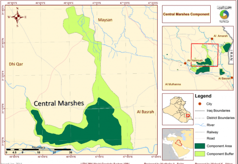
The Central Central Marshes are part of global systems, as they are part of the World Heritage property as they are a component of the Central Marshes within the World Heritage Convention. It extends between latitudes (31° 50 and 40° 32°) north to south and between longitudes (15° 46°) and 50 "47°") east to west. Figure 1 displays the area of study.
The area of the marshes in southern Iraq has varied, to the point that it is difficult to determine their area definitively, and the reason for this is the change in their area from one season to another and from year to year, due to their reliance for nutrition on the amounts of rain and snow falling on their main sources [6-8]. Studies by the Ministry of Water Resources and the Center for the Revitalization of the Iraqi Marshes and Wetlands indicate that the area of the central marshes before drying was 3000 km2 in 1979. location of the Central Marshes component and its adjacent areas. Barren, but the water was returned to it by the plans of the Center for the Revitalization of the Marshes. The submerged area after recovery reached 184 km2 in 2009, while the submerged area after restoration amounted to 653 km2 in 2018.
Figure 1. The location of the Central Marshes component and the surrounding areas
The Iraqi marshes are considered the largest wetlands in the Middle East ecosystem, as well as their cultural, social, and environmental importance. This area needs to be given the required attention in a promising development strategy based on the construction of dams to regulate water and benefit from the drainage of water surplus from the need to the marshes instead of going into Gulf waters. Also, it needs to activate development activities appropriate to the region with population stability according to the social and economic characteristics of the region’s residents. This area is unique due to its diversity of neighborhoods and an agricultural nature based on reeds, papyrus, fishing, and birds, in addition to promising potential for cultural-entertainment tourism activity [9].
This territory was exposed to utter and deliberate sabotage during the 1980s as a result of unjust policies, as evidenced by the withholding of water, the migration of its indigenous people, and its vulnerability to drought and eventual erasure, along with all its distinctive cultural and social legacy.
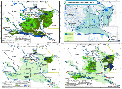
Extensive environmental damage to the area has been identified by the United Nations Environmental Program and the requirements of the World Bank to initiate the reconstruction of Iraq as one of the countries with the largest environmental and humanitarian disasters. In 2002, the United Nations Environmental Program (UNEP) 197 alerted the International Committee to the destruction of the marshes when it displayed satellite images showing the loss of 90% of the marshes [10, 11]. Figure 2 depicts the reality of drying up on the marshes of southern Iraq in the years 1970-1973, 1990-1998, and 2002. The experts were afraid of losing the entire ecosystem of the marshes within three or five years unless urgent measures were taken.
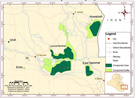
The marshes cover a considerable area in each of the three southern governorates (Maysan, Dhi Qar, Basra, and Kut), and are shaped like a triangle with its head in Basra and its two ends in Dhi Qar and Maysan. The area between the two rivers eventually expands as it splits into various branches, as the marshes of lower Mesopotamia reach from Samawah on the Euphrates and Kut on the Tigris to Basra on the Shatt al-Arab side [12]. The marshes are made up of a series of small lakes and marshes that drain into one another; as a result, some marsh units merge to form bigger wetlands. As illustrated in Figure 3, the wetlands' heart is centered in the area surrounding the confluence of the Tigris and Euphrates rivers. The marshes are divided into three interrelated systems: the central marshes, the Hammar marshes, and the al-Huwaiza wetlands, all of which are connected to the Arabian Gulf via the Shatt al-Arab [13, 14].
Therefore, the lagoons of the southern region can be divided into three main lagoons:
The eastern marshes refer to the marshes that are fed directly from the Tigris River and currently represent the Hawizeh marshes, which are located mostly in the Maysan governorate, such as the Al-Jabayish district, part of which is in the city of Basra. As for the southern marshes, they are the marshes that feed off the Euphrates River [11]. Most of them are in Dhi Qar governorate, and some of them are in Basra governorate. Because of the importance of the central marshes, their central location, and their biological and social diversity, this was one of the important reasons for choosing them as a study area for research.
Figure 2. Changing the marshes of southern Iraq during the year (1970-2002)
Figure 3. The main marshes of southern Iraq
The research employed an inductive analytical methodology using modern technologies and updated official data issued by the Ministry of Water Resources and the Marsh Revival Center in preparing a development strategy for the management of the central central marshes through geographic information systems. Herein, the research challenge is crystallised in the fluctuation of the amount of water input into the marsh region, which causes the land areas submerged there to constrict and expand. Therefore, the study's purpose is to examine the reality of the marshes of the marshes and determine how the submerged regions are changing and impacting the area.
5.1 Analysis and discussion of the factors and variables adopted in the study area
5.1.1 Nutrients of the marshes
It represents the river nutrients represented by the rivers (Tigris, Euphrates and Rain), whose quantities varied as follows:
5.1.2 Submerged spaces
The area of the marshes decreased from what it was before the drying in 1973 due to the low quantity of water imports of nutrients, and this is illustrated by the currently submerged area after recovery, which varied between the marshes of the three governorates in general and the central marshes in particular, from 2009 to 2018. Table 2 shows the areas of the central marshes for the base year 1973 and the comparison years in terms of the submerged area after the restoration of the marshes.
Table 1. River nutrients for the base year and comparison year, and a statement of the flood rates
|
Current immersion rate% |
Comparison year |
Capacity rate previous |
Base year |
Marsh feeders |
Study area |
|
8% |
2009 |
49.22 |
1998-1933 |
Imports of the Tigris River and its tributaries (billion m3) |
Central Central Marshes |
|
15% |
2010 |
34.21 |
2017-1997 |
||
|
43% |
2016 |
30.26 |
1972-1933 |
Imports of the Euphrates River (billion m3) |
|
|
31% |
2017 |
23.59 |
1989-1973 |
||
|
24% |
2018 |
16.53 |
2019-1994 |
Table 2. The areas of the central marshes for the year 1973 and the comparison years, the submerged area after the restoration of the marshes
|
Currently submerged area after resuscitation |
Year |
Area before drying 1973 km2 |
Study area |
|
184 |
2009 |
3000 |
Central Marsh |
|
370 |
2010 |
||
|
1060 |
2016 |
||
|
760 |
2017 |
||
|
586 |
2018 |
5.1.3 Environmental variable
The environmental variable clarifies the effects and variables resulting from the destruction of the natural environment of the marshes under consideration from both a natural and human point of view [15-18]. In view of the sharp decline in the level of water resources, the increase in water salinity, and the high levels of chloride, magnesium, and calcium in the water, the acidity rate increased, the amount of dissolved oxygen in the water decreased, and the plant diversity decreased, which led to the exacerbation of diseases to which humans and animals are exposed. In addition to the repetition of drying stages and the lack of nutrients and water imports that have negative consequences and effects represented in environmental, economic, and social effects as a result of changing the quality of the marsh water due to drought [19]. The quality of the water is affected by the re-flooding represented by sewage water, because the marshes have become fed with sewage water in two directions, which has led to a biological change in the quality of the fish and aquatic organisms that live there. The decline in the water shares feeding the marshes affects such things as the spatial extension of the marshes, the amount of water nutrition, the climatic conditions, the qualitative characteristics of the water, and the economic wealth [20-22]. Therefore, this study came to clarify the extent of the hydrological changes of the marshes and their evaluation to show their environmental and economic effects, and the clear impact these changes had on the environment, represented by local climatic changes, desertification, deterioration of agricultural lands, extinction of plant and animal life, and the destruction of an important industrial wealth. This means looking at the long-term development plans and coming up with programs that are right for the region's conditions. This will help the marshes' ecological and vital systems grow.
5.1.4 Economic variable
The fourth variable represents the economic dimension. It is a dimension that has an important and effective impact on the environment of the marshes and is greatly affected by the lack of imports and water quotas for the marshes, being a cradle of biological diversity and containing diverse, large, and important food sources at all nutritional levels that attract many types of organisms in large numbers [23]. It relies on them as a habitat or a source of food and for the breeding of birds, fish, and milk of various types and in commercial quantities on which the inhabitants of the marshes and the adjacent areas depend entirely for their livelihood on hunting them. Therefore, they provide a wide range of ecosystem services that contribute to human well-being. The area of immersion and expenditures negatively affect their economic basis. It is hunting and raising buffaloes. The imposition of more negative effects on economic activity. For example, the fishing line began to collapse in 1997, and the number of buffaloes decreased from 80,000 to about 5,000, with severe consequences for the marsh dwellers as the rate of migration caused by drought increased. Indeed, more than half of the population lives in rural or semi-rural areas and is reliant on fisheries and cattle, so the collapse of economic activity related with the marshes has resulted in rising unemployment and poverty rates. For instance, Dhi Qar is Iraq's poorest governorate, with the biggest proportion of the population living below the poverty line on less than $5.2 per day (8.37 percent) and the highest unemployment rate (19 percent). Maysan and Basra governorates also face the highest rates of poverty and unemployment in the country, which increased more than they did in 2007.
Reducing the water quotas for the nutrients of the marshes and the migration of the population led to a change in the economic activities of the returning population, as it was noticed that a number of the residents of the marshes purchased farms in the district center and opened special marketing outlets for them on the public streets of the district. The processing is done at a daily rate in addition to carrying out agricultural activity. Represented by the cultivation of rice, wheat, and barley, this reflects the interruption of the ecological extension of these activities, which were famous for the local population and which are included in the concept of the traditional knowledge of the inhabitants of the marshes.
The lack of water imports affected the economic activity in the whole region, and the majority of the population of the study area did not encourage the random return to the marshes, nor did they like unplanned flooding, which they believe has taken place in some areas of the marshes, in addition to the establishment of agricultural areas and the preservation of their existence. The marshes because they have adapted to agriculture, which is considered an extraneous activity to the environment, and many economic activities have continued despite the drying of large areas, although their relative importance varies from one village to another.
The flooding operations of the currently submerged area after recovery presented a new reality and a distinct and effective economic basis, which is the tourism activity that creates new horizons for the process of developing, developing and reviving these marshes.
5.2 Planning vision and development scenarios for the marshes
The water scenarios serve as a mechanism to know the directions of the relevant authorities in the process of selecting opportunities for providing water, in addition to taking into account the "assumption" that the countries of the upper rivers have developed 100% of the projects related to irrigation and infrastructure for water control, which are the upstream countries of river water in Iraq. The biggest challenge in front of water scenarios is to manage water optimally in light of the current data and what the foreseeable future will be due to the close relationship between water and food security, energy, and the environment and how to preserve them. It will put the scenario in front of the main goal of creating a delicate balance between the competing uses of water, and this is what the vision seeks.
The scenarios recommended of the current study relying on three axes of the amount of water flowing through the rivers to Iraq, which are:
Area restored: the restored area would correspond to the conditions in 2005. The total area reclaimed would be between 2,400- and 4,800-kilometers square. This scenario may be representative of the state that exists during normal to dry years.
Steps required: (a) Iraq would require a moderate degree of effort to improve its agriculture on both local and national scales and to ensure that sufficient water is available for the marshlands. (b) The schedule of water releases for agricultural irrigation and marshland agriculture would need to be synchronized. (c) Controlled releases should be used to replicate seasonal fluctuations in water flow.
Methodology: adoption of best agricultural practices, proper water management, limited infrastructure construction, and preparation of scheduled flow release plans to promote marshland regeneration.
Restriction: Some sections will remain seasonal marshlands during recovery, as full hydraulic communication between marshes is not possible. It is proposed that some extra regions be flooded, as illustrated in the following scenario, to maximize the benefits of marshland restoration.
Area restored: the restored area would be identical to what existed in 1990. The total area reclaimed would be between 4,800- and 7,200-kilometers square. Wet and flood years may be the only instances when this can occur fully.
Steps required: (a) Iraq would need to make significant efforts to upgrade its agriculture on both a local and national basis. (b) Timing water deliveries to wetlands in order to reduce evaporation losses and maximize agricultural water use. (c) Water allocation agreements must be reached with neighboring countries.
Implement best practices in local and national agriculture, proper water management, installation of large water control infrastructure, and formulation of scheduled flow release plans to allow for maximum marshland recovery.
Advantages: This condition represents the recommended level of marshland recovery because it would not interfere with other current and future land use, would allow for the implementation of some agricultural development plans, and would allow for some flexibility in terms of final marsh restoration area selection in order to maximize opportunities for productive field irrigation, petroleum, and other natural resource development.
Region restored: the restored area would be identical to the conditions in the 1970's. The total area reclaimed would be between 7,200 and more than 10,000 km2. This scenario may be possible only during years of high flooding.
(a) Significant efforts would need to be made in Iraq to modernize its agriculture, both locally and nationally. (b) Several locations currently used for field agriculture or petroleum development would be turned to marshes, necessitating the downscaling of agricultural development plans. (c) The majority of the water required for restoration would have to be imported. To obtain that water, agreements would have to be established with them.
Implement best practices in local and national agriculture, proper water management, the construction of massive infrastructure for water control, the development of scheduled flow release plans to maximize marshland recovery, and the reclamation of large swaths of land.
Limitations: This amount of recovery (together with the previous scenario of 25%) represents the bare minimum level of restoration that is conceivable. While entire restoration would permit the creation of the most biodiverse wetlands, the presence of so many big bodies of water and wetlands may constrain long-term national and local economic development. This scenario would face stiff opposition from local farmers and the nation as a whole, given Iraq's economy's reliance on petroleum revenue.
5.2.1 Scenarios for the recovery and development of the marshes
Given the importance of the marshes under consideration as one of the wet water systems in the middle of a continental climate and the lack of rainfall throughout the year, and the large area they occupy, represented by three large marshes located between three governorates inhabited by rural residents and containing a unique biological diversity, they have gained international importance and become part of the global heritage.
In view of this importance, it should have had a share of development, according to the following stages:
Even in the worst-case scenario, the scenario made clear to the three axes of water resources that there will be a share for the marshes of fresh water flowing through the Tigris and Euphrates rivers, the first being upstream countries and the projects they implement on these two rivers, and the second being climate change within the time frame that these scenarios indicated. Numerous crucial implications about the hydrologic model are immediately relevant to government officials. These are the following observations:
In addition, given that the marsh area has become a world heritage area with a unique nature, its permanence is dependent on the availability of water, and in return, this area is exposed to drought and thus removal.
The marshes are characterized by the potential for eco-tourism and recreational activities, which is considered an internal strength, as well as being a link between cities and rural settlements, especially the road linking the Al-Shib port in Maysan Governorate and the city of Nasiriyah.
Passing near the Al-Huwaiza Marsh and adjacent to the Central Marsh (as proposed in the "Strategic Framework for Urban Development in the Governorates of Iraq"), and from Al-Amarah to Al-Qurnah as an extension to the Hammar Marsh, where it penetrates (Road 24) to the city of Nasiriyah, as this axis is very active during religious occasions every year. This strongly urges not to neglect this axis, which corresponds to the current scenarios trends in the issue of linking between East and West, as well as the reality of the deteriorating countryside with its various aspects and its connection to the current reality of the marshes. Also, the subsequent stability and activities in them and their survival as part of the world heritage, if tourist areas are established near the marshes on the one hand. In addition, the establishment of villages within the marshes area, which will focus on a number of them for their development (as candidate villages for development) in order to integrate activities and have a mutual impact between the two. This greatly helps the residents’ adherence to their traditional activities, who are ready to gradually abandon them in light of the current developments on the lack of services in that region on the other hand. Furthermore, as much as the focus of this proposal is on the development of this area of the marshes, it does not mean neglecting the rest of the inhabited areas of the marshes in a way that guarantees their share of development. Numerous significant observations can be drawn from the model's early results:
The strategy contributes significantly to our understanding of the economic realities in southern Iraq. A critical component of this knowledge is the fresh information gleaned from a detailed social study of marsh dwellers, farmers, and city dwellers.
This scenario requires its development by focusing on the provision of infrastructure, mainly the construction of roads and the development of existing ones to be a destination for transportation. Also, the establishment of tourist facilities and services that you will require in selected areas and be close to rural settlements in particular so that there is a mutual benefit, as well as media and awareness campaigns for the population.
Their participation through training and work within this field, albeit by marketing the food and heritage products produced in the villages. This requires a great and serious effort on the part of the government in that region through the allocation of investments with the participation of the private sector, mainly to invest in these areas, which greatly helps in developing them to be an eco-tourism attraction and a religious tourism hub.
Figure 4. The marshes development area
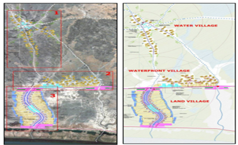
Figure 5. Scheme of the new Aden villages system
5.2.2 Criteria for the election of candidate villages for development
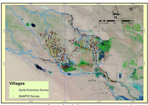
To complement the foregoing and to ensure that the various activities in the marshes exist with the population in the villages within the scope of the marshes, by selecting the villages that aim to develop them by providing various services to serve the population and stimulating the activities that derive their resources from the environment of the marshes and the expected tourism in them in the future. In this regard, the current study suggests that the following criteria be followed for the election of villages as shown in Figure 5.
Narrative mode
The study recommendations can be summed up as shown below:
[1] Maktoof, A.A., Zahraw, Z., Magtooph, M.G. (2020). Concentrations of some trace metals in water and sediment of main outfall drain in Al-Nassiriyia city by using pollution indices. In AIP Conference Proceedings, 2290(1): 020013. https://doi.org/10.1063/5.0028595
[2] Al-Lami, A.A., Salim, M.A., Mohammed, M.K., et al. (2014). Ahwar of Southern Iraq: refuge of biodiversity and the relict landscape of the Mesopotamian cities. Nomination Dossier for Inscription of the Property on the World Heritage List. The Republic of Iraq. https://whc.unesco.org/en/list/1481/.
[3] Al-Zaidy, K.J., Parisi, G., Abed, S.A., Salim, M.A. (2019). Classification of the key functional diversity of the marshes of southern Iraq marshes. In Journal of Physics: Conference Series, 1294(7): 072021. https://doi.org/10.1088/1742-6596/1294/7/072021
[4] Aoki, C. (2009). Support for Environmental Management of the Iraqi Marshlands, 2004-2009. UNEP/Earthprint. https://wedocs.unep.org/20.500.11822/7823.
[5] Partow, H. (2001). The Mesopotamian marshlands: Demise of an ecosystem. https://www.cabdirect.org/cabdirect/abstract/20046797676.
[6] Gültekin, I., Ince, N.H. (2007). Synthetic endocrine disruptors in the environment and water remediation by advanced oxidation processes. Journal of Environmental Management, 85(4): 816-832. https://doi.org/10.1016/j.jenvman.2007.07.020
[7] Mohammed Irzoqy, I.M., Ibrahim, L.F., Al-Tufaily, H.M.A. (2022). Analysis of the environmental reality of the marshes and its sustainable development. In IOP Conference Series: Earth and Environmental Science, 1002(1): 012010. https://doi.org/10.1088/1755-1315/1002/1/012010
[8] Bedair, H.M., Al-Saad, H.T., Salman, N.A. (2006). Iraq’s southern marshes something special to be conserved: A case study. Marsh Bulletin, 2(1): 99-126.
[9] Al-Maliki, G.M., Al-Khafaji, K.K., Karim, R.M. (2017). Antibacterial activity of two water plants Nymphaea alba and Salvinia natans leaves against pathogenic bacteria. Int. J. Fish. Aquat. Stud., 5(5): 353-355. https://www.fisheriesjournal.com/archives/2017/vol5issue5/PartE/5-5-25-551.pdf.
[10] Aoki, C., Al-Lami, A., Kugaprasatham, S. (2011). Lessons learned from environmental management of the Iraqi marshlands in the post-conflict period. Water International, 36(2): 197-206. https://doi.org/10.1080/02508060.2011.561770
[11] Angelevska-Najdeska, K., Rakicevik, G. (2012). Planning of sustainable tourism development. Procedia-Social and Behavioral Sciences, 44: 210-220. https://doi.org/10.1016/j.sbspro.2012.05.022
[12] Malinowski, J.C. (2002). Iraq: A Geography. https://eric.ed.gov/?id=ED476013.
[13] Lecerf, J. (1958). M. Salim SHAKIR (šĀKiR), Ech-Chibayish, an Anthropological study of a Marsh village in Iraq, vol. I, x+ 260 p., Bagdad (Rābita Press), 1956 (Thèse présentée à l'Université de Londres p our le doctorat en philosophie). Arabica. https://brill.com/view/journals/arab/5/2/article-p214_28.xml?language=en.
[14] Loukaitou-Sideris, A., Ehrenfeucht, R. (2011). Sidewalks: Conflict and Negotiation Over Public Space. MIT Press. https://doi.org/10.7551/mitpress/7423.001.0001
[15] Alwash, A., Alwash, S., Cattarossi, A. (2004). Iraq's marshlands-demise and the impending rebirth of an ecosystem. In Critical Transitions in Water and Environmental Resources Management, 1-9. https://doi.org/10.1061/40737(2004)1
[16] Alrikabi, N.K., Alumery, A.O. (2020). The environmental planning vision for development of human settlements in marshes by using GIS techniques. In IOP Conference Series: Materials Science and Engineering, 737(1): 012238. https://doi.org/10.1088/1757-899X/737/1/012238
[17] Cole, C. (2018). Controversial investments: Trade and infrastructure in Ottoman–British relations in Iraq, 1861-1918. Middle Eastern Studies, 54(5): 744-768. https://doi.org/10.1080/00263206.2018.1462164
[18] Al‐Mudaffar Fawzi, N., Goodwin, K.P., Mahdi, B.A., Stevens, M.L. (2016). Effects of Mesopotamian Marsh (Iraq) desiccation on the cultural knowledge and livelihood of Marsh Arab women. Ecosystem Health and Sustainability, 2(3): e01207. https://doi.org/10.1002/ehs2.1207
[19] Sukhdev, P., Wittmer, H. (2008). The economics of ecosystems and biodiversity. https://www.cducsu.de/sites/default/files/benutzer/4/dateien/berlin101006-teebpavan.pdf.
[20] Al-Musawi, N.O., Al-Obaidi, S.K., Al-Rubaie, F.M. (2018). Evaluating water quality index of Al-Hammar marsh, south of Iraq with the application of GIS technique. J. Eng. Sci. Technol., 13(12): 4118-4130. https://jestec.taylors.edu.my/Vol%2013%20issue%2012%20December%202018/13_12_17.pdf.
[21] Hashim, B.M., Sultan, M.A., Attyia, M.N., Al Maliki, A.A., Al-Ansari, N. (2019). Change detection and impact of climate changes to Iraqi southern marshes using Landsat 2 Mss, Landsat 8 Oli and sentinel 2 Msi data and Gis applications. Applied Sciences, 9(10). https://doi.org/10.3390/app9102016
[22] Chatelard, G., Abulhawa, T. (2015). The World Heritage Nomination of the Ahwar of Southern Iraq: Refuge of Biodiversity and Relict Landscape of the Mesopotamian Cities. Arab Regional Centre for World Heritage, Manama, Kingdom of Bahrain. https://policycommons.net/artifacts/1373871/the-world-heritage-nomination-of-the-ahwar-of-southern-iraq/1988108/.
[23] Rubec, C. (2013). A wetland future for Iraq. Marsh Bulletin, 8(2): 114-130. https://www.iasj.net/iasj/download/fea5e9123f21cb67.