Dalal A. Ismaeel* | Amina A. Khalil
© 2022 IIETA. This article is published by IIETA and is licensed under the CC BY 4.0 license (http://creativecommons.org/licenses/by/4.0/).
OPEN ACCESS
Al-Mishraq site was the title of many scientific types of research done due to its commercial, environmental, and groundwater pollution studies found that the pollution from the Al-Mishraq field hits soil and groundwater, eventually reaching the Tigris River. The process of hot water injection for sulfur extraction led to a change in the hydrological conditions of the area. The spread process of this water through the soil carries liquid dissolved sulfur towards the river that causes pollution of soil and river. The extent and concentration of dissolved sulfur were studied before and after proposed treatments. Also, the efficiency of these treatments would be estimated considering transport and diffusion theory in saturated/unsaturated states using the GEO-SLOPE software evaluating the extent of dissolved sulfur transfer through site soils in two cases. The first case represents the soil region without proposed treatments, and the second case represents the soil region with proposed treatments. The results show that a length of vertical barriers ranging between 180-200 m was efficient to prevent pollutants from moving. Also, the concentration and extent of contaminant spread in soil depended on the distance between vertical barriers and contamination source. Also, it found that at distances less than 300 m concentration of contaminant was high with a small range of soil, while at distances more than 300 m concentration of the contaminant was lower with a wider spread of soil.
sulfate, contaminant, vertical barrier, advection-dispersion
Soil contamination and groundwater with different sources of pollution, especially pollutants from solid and liquid waste sources, as well as one of the geo-environmental problems that have emerged in recent years [1].
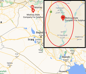
Al-Mishraq area located in Mosul city in northern Iraq, it is located about 45 km south of Mosul, on an area of about 40 km2. The use of Frasch processes a method of mining deep-lying sulfur, as the process of extracting sulfur requires several operations distributed in four areas within the facility. In the first area, the process of filtering the water used to extract sulfur drawn from Tigris River is carried out, While the second area completes the task of filtering the water until its purity reaches high levels, the hot water is then pumped to the third area is under 7 tam pressure to complete the sulfur extraction process by injecting the water to melt the sulfur in the ground and push it to the surface by hot pressurized air, and then send the crude sulfur to the fourth region for purification from the materials [2]. Figure 1 show the location of the site.
The process of sulfur production increases cracks and caves, allowing the sulfur to leak in soil and the Tigris River. Sulfate is the most prominent of pollutants [3] Groundwater moves from higher to lower pressure levels through cavities and pores in the rocks that fill it, controlled by both hydraulic conductivity and groundwater movement is typically small compared to surface water movement [4].
Al-Abbasi [2] conducted a study in the sulfur production area in Al-Mishraq, which was lasted for eleven months, during which many of the characteristics of polluted water and from different production areas were determined, as well as river water before and after the production area [2]. According to the study, the results of leakage in this area extend into the river for long distances, reaching more than 2000 meters south of the leakage area. The study concluded that the extraction operations in the region cause great pollution in the soil and water of the Tigris River. According to the researchers in ref. [5], the layers carrying free sulfur are characterized by different hydrological conditions, as the first layer sulfur has a very high flow coefficient, through which more than 62% of the groundwater seeps into the river. The second layer, which holds free sulfur, has a slower flow rate and allows about 26% of groundwater to enter the Tigris River. The third layer carries free sulfur, has a low flow factor, and seeps 12% of groundwater into the Tigris River [6]. To solidify sulfur and limit hot water infiltration into the river, Bashi et al. [7] demonstrated the effectiveness of injecting a cold water barrier into monitoring wells drilled in high hydraulic conductivity areas in the Mishraq area. So this method is considered more economical effective due to the possibility of converting the injection well into control towers or production wells when needed [7].
Basha et al. [7] found that the depth of the vertical barriers required to keep the pollutant at the top of the vertical barriers increases with time, the difference in height and permeability, and decreases with increasing the distance between vertical barriers and source of pollution [8]. Khattab et al. [3] depending on numerical representation using the GEO-SLOPE program were found that the rate of movement of dissolved sulfate have influenced by the permeability of the soil and the amount of dissolved sulfate [3].
Figure 1. Location of Al-Mishraq site
Recently, with the development of industry, a progression of problems has appeared such as groundwater and soil pollution. Therefore, restoration protection of pollution place has developed into one of the most important tasks now. Countries have successively conducted many researches on the repair technology of contaminated sites. Control and remediation technologies are mainly divided into three stages: source control of pollution, diffusion of air pollution control, and contaminated site restoration. Barrier technology is a remediation method that isolates polluted soil from the surrounding environment by using impermeable barriers, lining technology, grouting wall, sheet-pile, geomembrane, and mud wall are main divisions [9, 10].
Sheet piles could be used to prevent pollutants from moving horizontally and overflowing, isolating contaminated matter from surface water and groundwater inflow. According to Elarabily and Negm [11], by using a diaphragm wall, it is preferable to place it at the top of the slope rather than below the down gradient slope since it reduces the rate of pollution. Also, when the flow velocity is small due to low the hydraulic conductivity of soil, and the existence of the sheet pile is insignificant, according to results. Also, the number of soil layers affects on extent and concentration of contaminants, the vertical barrier would not be effective till it penetrates the impervious layer, and change in head differential has no effect on the contaminant migration process [11]. Finally, the best location is on the contaminant side, and vertical barrier penetration depth to reach impervious layer to reduce the proportion of reached contaminate to achieve best possible irrigation water protection [12].
According to the results of the study of Elamin et al. [13], the sheet pile method is the most cost-effective and flexible method of soil protection. Equal double vertical sheet pile is a method for controlling the distribution of pollutants in subsurface soil that is used and considered effective. Sandbox model and (MT3DMS and MODEFLOW) computer programs were used to study each variable that affects the depth of double sheet piles to delay contaminant arrival time to the downstream surface of the soil [13, 14].
Mansour et al. [15] concluded that using unequal double sheet piles could increase arrival time about twice that of a single sheet pile. Adsorption of phosphate on soil particles is linearly related to concentration, according to advection-dispersion analysis [16]. Make study about effects of vertical barrier walls on hydraulic control of polluted groundwater and discovered that incorporating an open vertical barrier wall with a gradient upward with one or more down-grading extraction wells can be very effective in reducing the rate of good drainage required to control the contaminant.
This study aims to shed light on the pollution of the soil that occurs as a result of sulfur extraction in the third area of the public facility for AL-Mishraq Sulfur and how this contamination reaches Tigris River. Discuss the efficacy of proposed treatments in two cases, first without treated, and the second with a treated method. Vertical barriers use as a means to treat the transfer of contaminants through the soil. These barriers are considered economic systems in protecting the soil and controlling the movement of contaminant water in the soil. These barriers were chosen as a type of treatment method in this manuscript, and because production in the mine stopped for a long time, this study came in a theoretical form, based on the available data from previous studies and research, as well as the report of the company executing the project in 1971.
Sulfate transport through the Al-Mishraq site was determined numerically using the SEEP/W and CTRAN/W packages. The physical characteristic of soil layers was summarized in Table 1. Fredlund & Xing method of saturated and unsaturated soils in the program was used to predict Soil Water Characteristic curve and hydraulic conductivity functions. The boundary conditions used were total pressure and the amount of water injected [17]. The CTRAN/W fraction was used to analyze sulfate movement using advection-dispersion analysis, while the SEEP/W fraction was used to represent water movement in the soil. These variables and boundary conditions have been chosen because they are appropriate for the selected studied case.
To study the effect of water movement and the diffusion of the contaminant represented by dissolved sulfate in water through the soil. The analysis was carried out using the two parts of the program (SEEP/W and CTRAN/W) according to the parameters as Saturated/ Unsaturated model, Effective Parameters, Hydraulic conductivity function, Volume water content function, Ky/Kx Ratio. The boundary conditions were represented as follows: water draining as unit flux, sulfate contamination as Concentration, vertical barrier sides as total flux (Q).
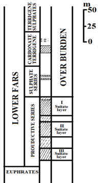
Ali [18] pointed out that Al-Sawaf mentioned in his study, and as investigations showed that the total thickness in the area is about 250 m) consisting of two main sections, the first: called the Overburden series and the second called the Productive Series layers in the Al-Mishraq mine area. This division is identical to the reports company executing the project in 1971, the thickness ranged between (88-124) m for the productive layer and with three sulfur-bearing horizons, separated from each other by stratigraphic overlaps of Marly dolomite. As for the covering layer, it was consisting of three chains: the first is the sulfate chain with a thickness ranging between (30-60) m, the second is the clastic carbonate chain with a thickness ranging between (40-60) m, and the sulfate chain with a thickness of about (62) m as shown in Figure 2. Table 1 shows the characteristics of the soil layers used in Al-Mishraq, according to what was mentioned in the previous studies. This manuscript relied on the characteristics mentioned in the above studies because production in the mine stopped for a long time, this study came in a theoretical form, based on the available data from previous studies and research, as well as the report of the company executing the project in 1971 [5].
The quantities of water flowing into each of the three Sulfate layers are 3.5, 1.5 & 1.1 × 10³ m3⁄day respectively [19].
Figure 2. Deposits profile [19]
Table 1. Permeability coefficient of soil layers [18]
|
K (m/days) |
H (m) |
Soil |
no |
|
$1.987 \times 10^{-2}$ |
141 |
Overburden |
1. |
|
299.808 |
29 |
Sulfate layer I |
2. |
|
$1.987 \times 10^{-2}$ |
10 |
Discontinuous bearing horizon |
3. |
|
299.808 |
24 |
Sulfate layer II |
4. |
|
$1.987 \times 10^{-2}$ |
18 |
Discontinuous bearing horizon |
5. |
|
99,965 |
18 |
Sulfate layer III |
6. |
|
$1.987 \times 10^{-2}$ |
>11 |
Limestone layer |
7. |
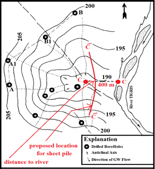
In this study, the Effect of using a vertical barrier to control sulfate transport through soil layers at three selected distances between vertical barrier and source of pollution (x) equals 100, 200, and 300 m, with vertical barrier depths (L), equals 145, 155, 165, 180, and 200 m, respectively, were investigated to reduce the sulfur transport arrival time to the Tigris river. The first three lengths extended approximately the top, middle, and end of the first sulfate layer production layer, and the second two lengths extended to approximately the top and end of the second sulfate layer production layer. The distance between the contaminant source and the river was 400 m which was mentioned in the figures as (C-C) because it represents the location of the nearest production line wells to the river, which was mention in most of the research conducted around the area, as in search of ref. [3], and [20]. Figure 3 shows the locations of the studied line (C-C), wells, and water flow directions seep into the river [20].
Figure 3. Groundwater and leakage water flow toward River [19]
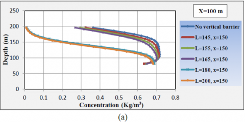
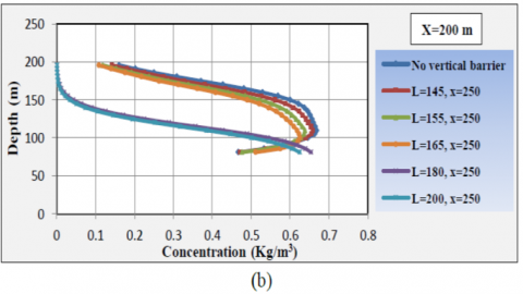
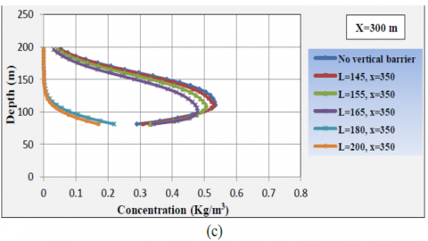
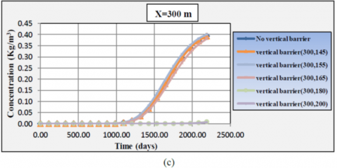
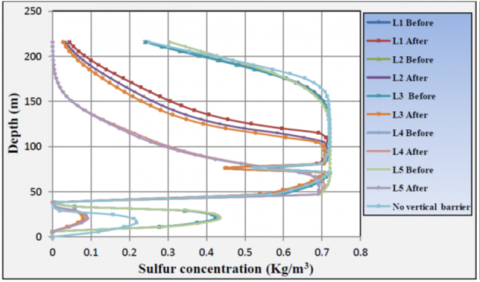
The Figure 4 shows the relationship between the extent and spread of sulfate pollution with depth for non-use and use of vertical barriers for chosen lengths in the study with three sections, every 50 m from three distances chosen to install vertical barriers in the study. In general, the figure shows that using vertical barrier with lengths of (145, 155, 165 m) is ineffective for impeding and preventing the spread of contaminant while using vertical barrier lengths of (180, 200 m) is effective in preventing the spread of the contaminant for three distances chosen in the study and a manner suitable at a distance of 300 m. This similar to what the researcher found [6], how found that the injection of water the design hydraulic barriers wells were successful for controlling the leakage, steering the direction of flow heated water, and stopping the molten sulphur reached the Tiger river [20].
As a result, it can be concluded that vertical barriers should be of a length (L = 180 to 200 m) and placed at a distance (300 m) or more from the source of contamination if used to prevent pollutants from touching Tigris River. It also noted that the thickness of the soil layer through which the contaminant is spread ranges between (25, 50, 85) approximately with (0.68, 0.62, 0.22 Kg/m3) concentrations at distances of (100, 200, 300 m) for chosen distances between vertical barriers. While a suitable distance is (X<100m) at the same lengths (L=180-200) m if the purpose of the treatment is to protect the soil of the area.
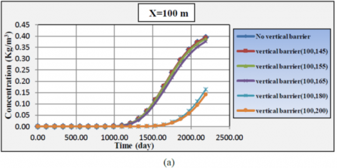
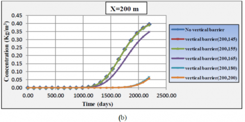
Figure 5 shows contaminant spread concentration versus time for 4.5 years, it is noticed from the figures that the time advancement increases the concentration of contaminant in soil mass at higher concentrations for both non-use and using vertical barriers for selected lengths (145, 155, 165 m), while low concentration of contaminant with time shown in case of vertical barriers with lengths (180, 200 m). The decrease in the contaminant concentration at the condition (L = 180, 200) m may be due to the extension of the vertical barrier to the second productive layer, which differs in engineering characteristics and drainage ratios from the first layers, thus there was a change in the contaminant’s disposal path.
Figure 4. Range of sulfate movement with depth at distances of 150, 250, and 350 m between vertical barrier and contamination source
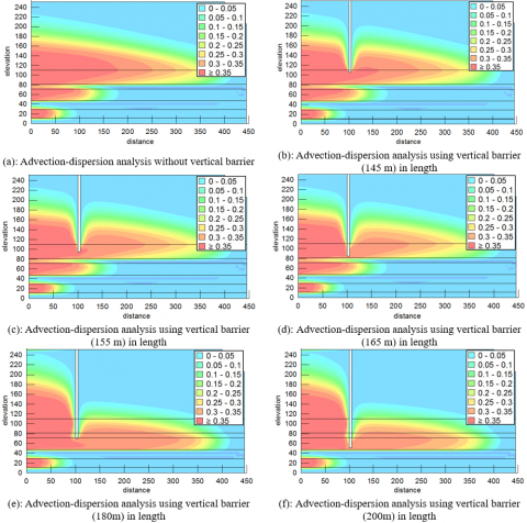
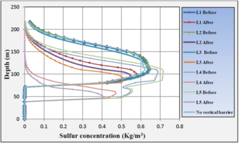
Figure 6 shows contaminate spread for studied cases non-use and using vertical barriers for selected distance 100 m, with lengths (145, 155, 165, 180, 200 m) for 4.5 years. Figures show that the presence of vertical barrier decreases contaminant arrival to the river, as well as an increase in contaminant concentration levels in soils before installation of vertical barrier. Figure indicate that the extent of dissolved sulfur spread with depth within the soil of the covering layer above the first production layer extends to a greater extent in the soil before the hydraulic barrier than after the vertical barrier, with few values after the vertical barrier. Also, the figure show that the extension of dissolved sulfur with depth at the top of the productive layer reduced when the vertical barrier extent of the second productive layer at lengths (L4, L5) while for the (L1, L2, L3), the values were a close extension of the distances selected in the study. This also applies to the other chosen distances (X=200, 300) m.
Also can be noticed if the purpose of the treatment using the vertical barrier is to protect the waters of the Tigris River from pollution, it would be more appropriate to choose the distance of the vertical barrier close to or within (300m). But if the purpose is to protect the soil and preserve the dissolved sulfur for re-extraction, then the distance to the vertical barrier should be less than (100 m). The figure also indicates that the extent of dissolved sulfur with depth within the soil of the covering layer located above the first productive layer extends to a large extent in the soil deposit before the vertical barrier more than the extent of its spread after the vertical barrier noting few concentration values after these barriers for all the selected distances (X=100, 200, 300) m, respectively.
(a): Probably sulfate arriving river when x=100
(b): Probably sulfate arriving river when x =200
(c): Probably sulfate arriving river when x=300
Figure 5. Contaminant concentration vs. time at a different length and distance of vertical barriers
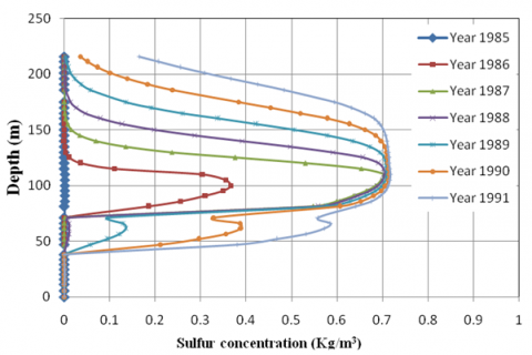
Figure 7 represents the extent of the dissolved sulfur in the soil of the studied area, that obtained from the theoretical representation of the condition of the region. The spread of contaminant for the case of without the use vertical barrier for the years (1985-1991). From the figure in general, an increase in the concentration and extent of the transmission of dissolved sulfur with time in general, as it is clear from the figure that the extent of the dissolution of dissolved sulfur with depth over time within the soil of the covering layer located above the first productive layer and with measured distances from the top of the first productive layer to The top towards the surface (10, 40, 65, 95, 115, 130) m for the years (1985, 1986, 1987,1988, 1989, 1990, 1991) respectively.
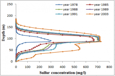
Also clear from the figure that the expansion of contamination spread pattern that obtained from the current study came closer to that which concluded by Khattab et al. [3], with some differences, this may be due to: the non-productive and three productive layers were represented with their characteristics and layer sequence which shown in Figure 2 and Table 1, while for the research study [3], the productive and non-productive classes that were confined represented as one layer with characteristics represent the average of these classes characteristics.
Figure 6. Contamination concentration after 4.5years, at x=100m
(a): current study
(b): study of Khattab et al. [3]
Figure 7. Comparison sulfate movement range with depth
Figure 8 shows the extent and spread of dissolved sulfur for the case of using vertical barrier for the chosen distances and length in sections before and after the vertical barrier, where Figure (8-a) represents the sections before and after the vertical barrier at (X=100m) for lengths (L=145,155,165,180,200) m and Figures (8-b, 8-c) at (X=200,300)m distances, respectively. The figures show that the extent of the concentration of the dissolved sulfur with depth at the top of the productive layer reduced when the vertical barrier penetrated the second productive layer. With distances above the first productive layer and upward towards the surface for lengths (L4, L5) was (90, 90 m), (80, 85 m), (45, 50 m) for the distance (X=100,200,300 m). As for the length (L1, L2, L3), the values were wider extended at the selected distances in the study. This came close to a study by Bashi [20] which demonstrated the effectiveness of injecting a cold water barrier into monitoring wells. researcher consider this method more effective to solidify sulfur and limit hot water infiltration into the river.
a: x=100m
b: x=200m
c: x=300m
Figure 8. Range of dissolved sulfur with depth for years (1985-1991) for treated condition
The following results were derived from a simulation of dissolved sulfate contaminants extent and movement through the soil in the studied area:
1. Vertical barriers can be effectively used to prevent horizontal migration of contaminants and their leachate, as well as to delay the time it takes for contaminants to move through the soil.
2. The vertical barrier length should be selected to meet the layer with the lowest drainage coefficient.
3. In the case of a small distance between contaminant source and vertical barrier site, increasing vertical barrier length did not affect the extent of contaminant extension, but there was a slight change in contaminant concentration.
4. Whenever the distance between contaminant source and vertical barrier is large, an increase in vertical barrier length has a significant effect on the extent of contaminant extension.
5. Since the first layer model has a higher hydraulic conductivity and water flow rate than other layers, pollutants are moved faster.
6. Vertical barriers used with (L= 145, 155, 165 m) are ineffective in preventing the spread of the contaminant while using (L= 180, 200 m) is effective for reducing the extension of the contaminant for the three selected distances in the study.
7. We can conclude also that the most appropriate length of the used vertical barrier to impede the movement of the contaminant to reach the Tigris river is with a range (L = 180-200 m).
[1] Al-Daood A.A. (2010). A study of contaminate diffusion through layered soil due to leachate migration from landfill site. AL Rafdain Engineering Journal, 19: 28-42.
[2] Al-Abbasi, K.M.H. (1988). Study of pollution resulting from industrial process in Mishraq sulfur state enterprise. Unpublished MSc thesis, University of Mosul, Iraq.
[3] Khattab, S.I.A., Khalil, A.A., Ibrahim, A.A. (2013). Dissolved sulfate transport through soils in AL-Mishraq deposit. International Journal of Geotechnical Engineering, 7(4): 355-363. 10.1179/1939787913Y.0000000009
[4] AL-Ubaidy, G.Y.A. (2008). Study for quality of the ground water in mishraq-1. Al Rafidain Eng. J., 16(4): 41-52. https://www.iasj.net/iasj/article/44744
[5] Mahmoud, S.S., Sadiq, Z.D. (1985). A study on the reality of the Mishraq sulfur Mine, General company of Geologic survey and mining, Interior report number 1583.
[6] Saud, Q.J. (2008). A comparative study before and after production stoppage from Al-Mishraq sulphur Mine, south of Mosul central North Iraq. J. Geol. Recruitment, 4(2): 25-36. https://ibgm-iq.org/ibgm/index.php/ibgm/article/view/84/82.
[7] Basha, A.M.A., Al Nimr, A., Rashwan, I.M.H., Gabr, A.M. (2012). Use of sheet piles to control contaminant transport through the soil. Journal of American Science, 8(12): 568-573.
[8] Arshad, I., Vallejera, C.A.E., Khan, Z.A. (2019). Finite element analysis of phosphate movement through a clayey-sandy soil by using geo-slope software (CTRAN/W). PSM Biological Research, 4(1): 20-28. https://psmpublishers.org/wpcontent/uploads/2018/12/BR-2018-057.pdf.
[9] Wei, L., Lv, Z., Li, S.H., Feng, G., Li, J., Shen, K., Miao, Z., Zhu, H. (2018). Application and Case Study of Barrier Technology in Soil and Groundwater Remediation. Science Press and Springer Nature Singapore Pte Ltd.
[10] Kui, H., and Xiangping, L. (2019). Application status of vertical barrier technology in site contamination remediation. IOP Conf. Series: Earth and Environmental Science, 242(5): 052029. https://doi.org/10.1088/1755-1315/242/5/052029
[11] Eltarabily, M.G.A., Negm, A.M. (2015). Numerical simulation of fertilizers movement in sand and controlling transport process via vertical barriers. International Journal of Environmental Science and Development, 6(8): 559-565. https://doi.org/10.7763/IJESD.2015.V6.657
[12] Eltarabily, M., Negm, A.M., Valeriano, O.C.S. (2015). Protection of irrigation water from phosphate transport through the layered soil by using vertical barriers walls. Eighteenth International Water Technology Conference [IWTC18], Sharm El Sheikh.
[13] Elamin, A., Nimr, E., Abdul, K.S., Ibrahim, A. (2015). Soil protection from lead contaminant using sheet pile or isolation methods. Mansoura Engineering Journal, 40(3): 1-7.
[14] Armanyous, A.M., Ghoraba, S.M., Rashwan, I.M.H., Dapaon, M.A. (2016). A study on control of contaminant transport through the soil using equal double sheet piles. Ain Shams Engineering Journal, 7(1): 21-29. https://doi.org/10.1016/j.asej.2015.11.009
[15] Mansour, M.M., Fathy, A., Helal, E., Rashwan, I.M.H., Sobieh, M.F. (2018). Delaying solute transport through the soil using unequal double sheet piles with a surface floor. Ain Shams Engineering Journal, 9(4): 3399-3409. https://doi.org/10.1016/j.asej.2018.10.003
[16] Anderson, E.I., Mesa, E. (2006). The effects of vertical barrier walls on the hydraulic control of contaminated groundwater. Adv Water Resour, 29(1): 89-98. https://doi.org/10.1016/j.advwatres.2005.05.005
[17] Fredlund, D.G., Xing, A., Huang, S. (1994). Predicting the permeability function for unsaturated soils using the soil-water characteristic curve. Can. Geotech. J., 31(3): 521-532.
[18] Ali, M. (1989). Hydrogeological study of Mishraq sulphur mine. Unpublished MSc Thesis, University of Mosul, Iraq.
[19] AL-Dabbagh, R.H., AL-Dabbagh, M.A.S. (1983). The regional effects of the effluents from the Mishraq sulphur Mines in Iraq on the hydrological system. Hydrological Sci. Journal, 28(2): 311-317.
[20] Bashi, T.D.M. (2010). Utilizing hydraulic barriers to reduce leakage of hot water and enhance sulphur production at Mishraq mine northern Iraq. Iraqi Journal of Earth Sciences, 10(2): 35-50. https://doi.org/10.33899/earth.2010.5520