Haneen Ali Abd Mohy* | Khanssa Ghazi Rasheed
© 2022 IIETA. This article is published by IIETA and is licensed under the CC BY 4.0 license (http://creativecommons.org/licenses/by/4.0/).
OPEN ACCESS
In the urban context, the sustainable static approach has evolved into a resilient orientation, determined by the dynamic urban characteristics of the cities, especially with the increasing challenges such as rapid urbanization, the emergence of different uses at the expense of urban green spaces, neglecting the ecological role that these spaces provide. The research starts from the need for an urban landscape that provides ecologically resilient contributions, it adopts the evaluation of urban resilience concerning the ecological urban landscape, by studying a part of the city center of Basra - Iraq. It aims to formulate guidelines that support the ecosystem by developing a multi-level theoretical framework based on the urban resilience principles to increase the ability of these spaces to innovate and stay strong during long-term change. The current study focuses on providing comprehensive knowledge about the ecological mechanisms and indicators that achieve resilience in the context of the urban landscape, and then answers the research question about the relationship between ecological urban landscape and resilience from a morphological point of view. We based on space syntax theory, using the analysis program (Depth map) to measure the morphological indicators through the main streets network, then analyzing their spatial relations with the green and open spaces as an integrated urban landscape to complete the evaluation and provide conclusions that can be used with other samples.
ecological urban landscape, morphology, space syntax, resilience principles
Urban ecology views to the city as an ecosystem that is built by human activities and supported by natural and human-made functions over time. Eco-urban landscapes are complex dynamic systems, possessing dynamic resilient relationships, that create spatial and temporal urban continuity. It can be considered the most important functional component in influencing the environment and plays a leading role in promoting positive development, it also provides a visual structure that increases entertainment values in cities, thus at the present time, these spaces must become vibrant and sustainable and provide multiple ecological and social functions. Urban resilience is a dynamic, complex, multidimensional concept; ecological, economic, social, and physical, it has been considered through a set of principles in the urban context that has been described as the most repetitive and resilient. Thus, whenever the idea of resilience is included in its dynamic concept and with a focus on the ecological aspect of urban landscapes, these spaces will be more effective when certain dysfunction occurs, which can follow an increasing trend in the future. Due to the neglect of the ecological role provided by these spaces, high-density urbanization movements seriously threaten the natural environment, violate the traditional spatial logic, harm the physical environment of contemporary cities, and contribute to the emergence of various uses at the expense of urban green spaces, and accordingly the need to address these gaps to achieve an urban landscape that provides environmentally resilient contributions. The current study focuses on presenting the resilient ecological urban landscape by exploring the mechanisms and indicators that achieve the principles of urban resilience through it. Accordingly, the objective of the research was to formulate guidelines that support the ecosystem and provide a multi-level theoretical framework based on the principles of urban resilience that contribute to increasing the ability of urban landscapes to innovate and stay strong through long-term change, and then provide a comprehensive assessment within the study area according to the indicators. we working on modeling the spatial organization of the important main street network in the urban fabric of the city center of Basra - Iraq by using the space syntax theory and methods in the Depthmap10 analysis program to analyze the urban road network as an axial map and select some of the main axes within its urban fabric, that are related to green and open urban spaces that affect in the spatial organization of land use with those axes as an integrated urban landscape. We examine the basic ecological indicators that achieve resilience in order to be able to measure, evaluate and quantify the interrelationship between resilience and the ecological urban landscape from a morphological perspective. The results indicate that urban environments that have urban spaces connected to nature are the most capable of morphological development and innovation, and therefore the most resilient. Actually, more resilient axes actually got lower values in the configurational analysis indicators, Whereas the highly integrated axes are completely separated from the open space, in other words, the resilience performance was high with the part strongly associated with the green and open space extension where most of the ecological resources are located, The research emphasizes finding integration between functional morphological indicators and ecological indicators in order to achieve the resilience of ecological urban landscape from a morphological perspective, That is, the support for urban resilience stems from the spatial morphological l configuration of the area, which requires resolving contradictions and finding solutions that support the ecosystem to increase The ability of these spaces to innovate and stay strong through long-term change, and is what the research suggests directing. The remainder of the paper is organized as follows:
The second section (Materials and Methods) is based on a review of previous studies that have addressed the main research themes, formulating the theoretical framework after exploring the ecological mechanisms and indicators in the urban landscape related to the resilience principles, determining the analysis methods and study area, we explain the processes of collecting data and studying the road network and open spaces within the land use in the city center of Basra.
In the third section, (Results and Conclusions),we provide a comprehensive evaluation of resilience through discusses the results of the space syntax analysis of the city center of Basra , and selecting a research samples , then applying of ecological indicators of resilience principles with those samples, to verify the hypothesis (indicators of the resilience principles vary in achieving a resilient ecological urban landscape, and that activating resilience within those spaces requires rethinking of the traditional indicators of morphology by emphasizing that attention to the physical-ecological side of the city can reduce vulnerability and enhance resilience).
In the last section, presents the conclusions and recommendations.
2.1 Literal review: Definition and concepts
2.1.1 Urban resilience
The development of resilience witnessed a long history of meanings in different fields and it was first defined by Holling in 1973 as a descriptive term in the field of ecosystems as the ability of an ecosystem to maintain basic functional properties to resist a specific defect. Later, resilience was explored in different types of research such as environmental studies, disaster prevention, climate change mitigation strategies [1]. The concept was gradually used in urban research, and gained importance with the emergence of environmental crises and unexpected changes in the urban fabric, and today it can be called one of the most productive keywords in urban literature because the cities need an adaptive approach to increase the resilience of its urban components in the face of crises, Urban resilience is a multifaceted entity, including environmental, economic, social, institutional and physical dimensions. Through a review of the literature on resilience, it was found that there are three types of resilience that can be identified, as in Table 1 [2]. In general, the new debates about urban resilience are related to ecological resilience, where resilience in its urban context does not always require a return to a previous state of equilibrium, but it will allow for the possibility of future change by continuity of structure and function to accommodate the positive consequences of changes and achieve transformations [3].
Table 1. Types of resilience [3]
|
Resilience types |
Purpose/objectives |
Focus |
Responding to |
|
Engineering resilience |
Maintains efficiency of function |
Efficiency, consistency, predictability |
External disturbances |
|
Ecological resilience |
Maintains existence of function |
Persistence, change, unpredictability |
Internal &external |
|
Evolutionary resilience |
Maintains the ability to change |
Persistence, adaptability, and transformability |
With or without any disturbance |
2.1.2 Morphology of urban landscape
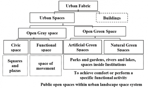
The term of morphology originated from two words (morph and logy), it means the logic of form recognition, the buildings, gardens, streets and parks are the basic elements of morphological analysis [4]. The concept of landscape encompasses more than an area of land with a certain use or function, it is considered as a synthetic and integrating concept that refers both to a material-physical reality, originating from a continuous dynamic interaction between natural processes and human activity, and to the immaterial existential values and symbols of which the landscape is the signifier [5]. The urban landscape constitutes a system for the city’s green space and provides importance for urban development. In recent studies, the urban landscape has extended from the protection of the ecosystem and improving the quality of the urban landscape to the systems of coupling the urban landscape with the urban morphology in various aspects such as the spatial organization for the elements of the formation of the natural urban landscape (such as rivers and lakes) or artificial (such as roads, green roads, and parks [1]. Urban Landscape consists of open and green spaces in an urban environment that is not independent of the surrounding structures and buildings and is usually a complex mixture of buildings, roads, trees, soil, and water that forms the basis for creating places. It provides tangible evidence of continuity and a sense of place in the changing urban environment and contributes to the formation and uniqueness of its morphological structure [6]. In general, urban areas include both the built environment and open space. Open spaces (the external environment) include two main categories that express the morphology of open urban space [7], as it is summarized in Figure 1.
Figure 1. Diagram of spaces in urban landscapes [7]
According to the above, the urban landscape morphology is formed through green urban spaces with some open urban spaces, natural and semi-natural sites that include sensitive and important ecosystems, the complementary elements of the landscape, all of them are intertwined with the street network in the urban fabric structure as an integrated system that provides tangible evidence of the continuity and the uniqueness of its morphological form.
2.1.3 Ecological urban landscape
Urban ecology is defined as "the study of the ways in which human and ecological systems develop together in areas of continuous urbanization", and it considers the city as an ecosystem that is built by human activities and supported by natural and man-made functions over time. The development of such an approach to ecology could be traced through the ecology of urban landscapes [8]. Urban ecology is an interdisciplinary field that contains many tools to enhance the sustainability and resilience of cities [9]. The Ecological Urban Landscape is the most important functional element in affecting the environment, it uses urban ecology as a strategy for designing and re-designing urban landscape and public spaces by taking advantage of the ecological orientation in the degraded spaces to shift to the green orientation, starting from the parts of the landscape to the overall urban landscapes in the urban fabric [10]. The Urban landscapes in their ecological aspect are seen as simple dichotomies between "green" and "gray" where "green", where green represents (the natural environment), and gray represents (the built or artificial environment). In other words, urban landscape is a gradation of urbanization extending from regions" dark gray” to “deep green” are arranged in complex patterns, some fragmentary created by countless local urban development decisions and others able to persist only in areas less affected by urban development. Basically, and in current trends, gray urban landscapes must become increasingly green and rely on the integration of both systems; artificial and natural, with great importance given to the ecology of the site [11].
In the context of urban landscape, the ecological aspect focuses on the structure and functions within this structure, which results from the spatial organization of urban patches and corridors as main elements, from the point of view of a (matrix model: patch - corridor) to describe the spatial patterns in the urban landscape and attempt to find patterns and interrelationships between those elements. Urban patches mean a restively homogeneous non-linear area that differs from the surrounding areas and it has a distinctly different structure and function such as (sports parks, gardens, agricultural lands) can be quantitatively described by size, shape, and location in relation to other patches [12], while the urban corridors represent elements of linear or strip landscape, and include natural or compact corridors, borders, roads, paths, linear gardens, and strip corridors( such as green belts), these corridors make the spatial pattern of urban landscape inclusive and internal [13]. As for the matrix, it is the background in which these urban patches and corridors are located, often developed from natural lands such as agricultural land or from artificial urban areas.
According to the above, the Ecological Urban Landscape is the most important functional element in affecting the environment, It uses urban ecology as a strategy for designing or re-designing urban landscapes in order to transform into a green orientation, it focuses on the spatial structure and functions within that structure resulting from the spatial organization of patches and corridors that overlap among themselves to form a homogeneous structure linked to biological diversity on the one hand and supporting the ecosystem of the place, on the other hand. It also increases interdependence between the natural environment and the artificial environment to integrate formation across the scales.
2.1.4 Ecological urban landscape as arenas for urban resilience
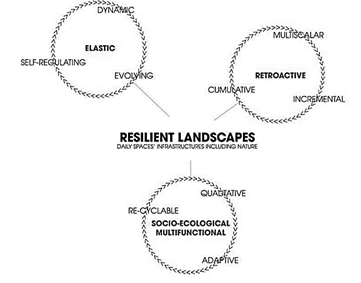
In this paragraph, we present a set of studies that dealt with resilience and urban space from its ecological aspect, directly or indirectly, in order to define the concept, extract the aspects associated with it, and determine the principles of resilience. The concept of resilience in urban landscapes represents the other vision of sustainability, which is not related to maintaining landscape in a stable state by reducing the variance in the dynamics of urban landscape or improving their performance, the focus is also on the adaptive capabilities of urban landscape to deal with uncertainties [14]. The term resilience of urban landscapes is used to refer to the resilience of the entire landscape, viewed as a spatially located complex adaptive system that includes both social and ecological components and their interactions, multi-level, self-organizing, it has the ability to absorb changes over time and achieve a state of relative stability through the self-regulating feedback that characterizes it [5]. The process of change towards resilience is related to the resilience cycles of resilient urban landscapes, which are the phases that determine that change or transformation, resilient landscapes are featured by rhythms of elasticity (being self-regulating, dynamic and evolving), retroactivity (being multiscale incremental and cumulative) and socio-ecological multifunctionality (being adaptive, qualitative and re-cyclable), as shown in Figure 2.
Figure 2. Resilient Landscapes cycles
Resilient urban landscapes are defined by qualitative criteria and not Through quantitative criteria, allowing the creation of resilient, ecological and multifunctional urban landscape [15]. Ahern [16] explained that the purpose of the resilience of urban landscapes is to create ecosystem resilience, by including five principles and counting them as indicators of resilience (biodiversity; connectivity; multifunctionality, redundancy, modularity, environmental adaptive design), and linked these indicators to the social aspect and ecological response to changes. Beller et al. [17] refer to the concept of resilience in urban landscapes from an ecological point of view, as the ability of landscape to maintain desirable ecological functions, strong indigenous biodiversity, and critical landscape processes over time under changing conditions, whether in human-controlled spaces or in the natural areas, as well as through bio-design and green infrastructure that achieves the integration of urban landscape with ecosystem services with a deeper connection to the natural world and place, and thus determined the principles of resilience in urban landscape by: connectivity, diversity, complexity, redundancy, spatial distribution and people, they presented its indicators with regard to climate change as a type of crisis that the study dealt with in particular. Koren & Rus [18] presented the resilient urban landscape by categorizing it into open spaces, green spaces, and unexploited spaces, explaining the different principles of resilience that these spaces possess, as well as their indicators related specifically to natural crises (disasters), explaining that not all open spaces are suitable for all types of crises and the goal of resilient urban space is to achieve the level of performance of pre-event resilience at least in an acceptable time. The principles that characterize resilient urban spaces include (redundancy in providing spaces to provide a safe space for movement, modularity, diversity in the ecosystem, diversity of open urban spaces spatially and functionally).
Through the studies presented above, it was found that resilience in the ecological urban landscape deals with these spaces as a complex, integrated, multi-level adaptive system that includes physical and ecological components and their interactions, is characterized by self-organization and the ability to absorb changes over time, maintain the structure and provide multiple functions. We can identify five major common principles that are frequently mentioned in the researchers' proposals, including (connectivity, diversity, efficiency, redundancy, and modularity). It was noted that the indicators for those principles are different in dealing with crises between natural and urban crises, with the emergence of a focus on the first type, while there are other types of crises that deserve attention, It is also not comprehensive with regard to the urban landscape from its ecological aspect, according to that, the field of research was determined in clarifying the role of these principles in the performance of resilience by exploring the mechanisms and ecological indicators associated with the urban landscape to resist changing dynamics (environmental, social and economic).
2.2 Theoretical framework
Through the analysis of a group of studies related to the limits of the research; we identified the ecological mechanisms and indicators associated with the principles of resilience in the context of the resilient urban landscape, taking into account that the variables and their indicators are measurable, as follows:
2.2.1 Connectivity principle
The Communication expresses the spatial continuity of urban landscapes, which is also closely related to their functions [19]. It was concluded that this principle is related to the following interventions or mechanisms:
1. Ecological rhythm: Studies have proposed this concept as an effective concept that deals with the issue of crises affecting natural elements and how to tame nature so that it is not destroyed, and that By basing urban development on the strong synergy between natural and urban landscape to re-correlate the different scales to activate the possibilities of resilience, and generate other possibilities for urban life, and discovering the ability of physical environments to overcome shocks and instability, according to two aspects [20-22]:
- The First Aspect / Nature as Structure: The focus is on the natural urban space (topography, rivers, river banks, fields....etc.) when it comes to facing long-term changes, its variables include: the harmonization of successive layers of change through (integrating the natural formation element to protect the ecosystem and visualization of coordination between different levels of change to create a new way of living), Connecting the structure of landscape with the integration of functions and uses to address the separation when facing potential pressures, enhance the connection with the natural potentials through (transparent buildings integrated with open space, the resilient terraces or anchorages to access the river, the pedestrian bridges at street level that provides a view of the river / or green space, continuity of the axes and visual openness towards the natural formation element).
- The second aspect/ the reparatory nature : It depends on nature’s ability to regenerate to avoid a sudden event to activate the possibilities of resilience in urban space and provide new possibilities, its indicators include: availability of natural reserve spaces that restore contact with nature, restore value to natural spaces by linking landscape and architecture, Providing non-ecological services to combine development and renewal using technical solutions to retain river water or environmental protection for waterways as an ecological element influential in promoting biodiversity, Greening and shading the public space.
2. The Spatial organization between the natural and artificial urban contexts: The spatial development of urban landscapes in a contemporary context aims to create sustainable and resilient urban spaces, and takes into account the principle of connectivity through some of the concepts described as strategic interventions for spatial organization, during which can be blended natural and built elements together to achieve an orderly arrangement in the urban landscape towards long-term resilience, according to the following intervention and their indicators [2, 23, 24]:
First/ Strategic activation of the interconnecting green network elements: utilizing that network as an integrated concept provides an integrated and valuable approach to moving to comprehensive and resilient urban landscapes that help move beyond traditional spaces and to re-organize the spatial urban spaces and within the framework of solutions based on enhancing the artificial connection with the natural environment, which also plays an important role in maintaining functions [2], The connection here includes two influential aspects of measurement in the context of the ecological resilient urban landscapes:
1) Structural- physical connection: It determines the pattern of urban landscapes and helps in forming a resilient urban landscape for different types of green and open urban spaces. The importance of small green spaces lies in the relationship with the distance people travel and their need for social interaction, and the focus is on the following indicators: integrated movement axes (pedestrians, bicycle transport) that facilitate movement, a linear green space adjacent to the river that enhances the connection with the river and movement with the axes, Pedestrian paths interconnected with recreational spaces and transport nodes.
2) Space connection: It contributes to the availability of resilient ecosystem services that support biodiversity, it is achieved through multifunctionality, which is the primary mechanism for contributing to urban resilience, and aims to intertwine functions by using a defined space more effectively and thus enhancing the ability of urban green spaces to interconnect and provide valuable services [23, 24].
Second/ Activating the elements of ecological network: It is concerned with the protection and compensation the effects of urban landscape fragmentation to create a spatial organization that increases the interpretive and entertainment values of the urban landscape, it also provides a visual structure and clarity in the urban landscape, as well as facilitating integration and interdependence in order to restructure the ecological urban landscape. The concept is defined as patterns of urban landscapes associated with two main aspects [8, 25]:
1) The spatial structure of the ecological network: It is defined by the spatial relationships between the distinctive ecological elements that make up urban landscape, and is described as intersecting ecological corridors and patches, these corridors make the spatial pattern of urban ecosystems comprehensive and internal, within two categories:
- The natural context: includes the natural patches such as (natural vegetation areas and water bodies), natural corridors such as rivers and streams.
- Artificial urban context: It represents artificial patches such as (parks, sports stadiums, empty lands), and artificial linear corridors that are more connected such as (fabricated waterways, access networks (roads and paths), green belt-like corridors, other built networks that contribute to its formation).
2) Availability of supporting ecosystem services: This concept has become an important tool in urban landscaping and urban design, and it is concerned with services that humans need and receive from nature [16], and are divided into four categories :provisioning services (food, water, and productivity of natural resources), regulating services (water and air filtration, climate and food regulation processes), supportive services (food recycling operations, habitat provision), cultural services (cultural, educational services and aesthetic benefits) [11].
2.2.2 The principle of diversity
Diversity is critical to taking into account the intrinsic ability of places to continue to succeed despite changes in economic conditions, technology and culture, it plays a vital role in the processes of reorganization and renewal of urban landscape that have been exposed to crises, and it is seen as an essential feature for dealing with change in productive ways as well as contributing to the enhancement of the multiple functions that support the performance of urban space. Self-Organization and the ability to learn and adapt are important attributes of managing diversity in effective ways, Diversity is directly related to the concept of spatial diversity, which is related to the spatial distribution of structural elements of urban ecological spaces to achieve equal access to basic services and reduce the risk of entire spaces being affected by crises [26]. Diversity relates to two measurement variables:
The first aspect /Diversity in the general urban formation of the city between square, rectangular, linear, organic, grids, corresponding to the local topography, the diverse formal organization contributes to enhancing the ability to innovate and perform resilience.
The second aspect/ supporting the original ecosystem of the place: The concept of resilience is a strategic concept rather than a normative concept, and in order to be effective, it must be explicitly based on the environmental factors and ecological dynamics of a specific place [25]. This aspect is achieved through the availability of the following:
1. Heterogeneity in spatial patterns, which represents the cornerstone of ecological design and ensures the achievement of a resilient and effective space. There are simultaneous indicators that include (heterogeneity in the shape and size of urban patch, diversity in the characteristics of urban corridors, connectivity with the urban context), and they represent methods of evaluating and completing patterns of urban landscape from the point of view of ecology and examining environmental quality over time.
2. Enhancing biodiversity which will in turn improve ecosystem services for urban landscape to support abiotic functions and services through the diversity of green spaces that can be found, shaped, configured and managed (community gardens, farmland, river branches and pathways), The general vegetation cover with important movement pathways may be the most important for urban biodiversity. Diversity of ecosystem services can be presented, in the context of the dynamics and crises of urban spaces over time; and view urban biodiversity in the context of response diversity that collectively supports specific functions and responds differently to change for resilience, which means that restoration of the natural system should stem from the original ecosystem of the place [24].
2.2.3 Efficiency principle
Efficiency in relation to resilience does not mean high structural simplification, but on the contrary, it requires an increase in structural complexity on every scale. Efficient use of urban space is essential for all urban environments [27]. This principle contributes to increasing the exploitation of resources and providing new opportunities for urban ecology to become a decisive element in urban spaces through achieving integration in these spaces [28]. Urban efficiency can be increased from an environmental point of view while providing new opportunities for urban ecology to become a critical component of resource efficient urban fabrics by utilizing the spatial characteristics of different urban tissues, each urban fabric contains a specific set of spatial relationships, building patterns and specific land use patterns, Including various opportunities or constraints for the integration of natural systems, which requires the design of appropriate tools to activate resource efficiency to enhance resilience from an environmental point of view with the reconciling and integration of urban spaces by investing in the following tools [29, 30]:
1. Ecological Integration: a major movement within the city’s policy and practices through the possibility of creating a high-tech mass fabric by blending green space with built structures,
2. Ensuring the determination of the absorption capacity within environmental limits to show how nature can be integrated and simulate the nature’s own system. It means that urban green spaces are no longer limited to undeveloped land and lands, but can also be integrated into, within and above built structures such as: integrated green walls and green roofs as biophilic facades in buildings.
The Environmental efficiency is one of the main tools for promoting sustainable development transition and stimulating technological innovation while reducing the negative impact on the environment. This can be achieved through the use of fewer natural resources and less energy and the adoption of recycling, as follows; First: The possibility of benefiting from increasing energy efficiency by using environmental standards, paying attention to the use of energy sources in the fabric of built spaces, preventing unsustainable spatial patterns of construction and their effects on energy consumption, using more sustainable building materials, and taking into account the design in order to obtain solar energy. Second: Giving importance to man-made ecosystems where technology is introduced with the aim of creating a convergence between the built and natural environment through industrial control to improve environmental performance and preserve ecosystems using alternative technologies. Third: the integration between human and natural systems, because nature has a self-ecological control that can be benefited from urbanely [20].
2.2.4 The principles of redundancy &modularity
The studies indicate that each of them is strategies to mitigate and perform resilience, and redundancy, according to studies [31, 32]. Redundancy is a structural feature that helps in the continuity of urban landscape when exposed to traumatic events, it refers to the presence of multiple components or similar functions and describes the availability of alternative resources, components or pathways that perform a backup function, which provides support and enhances the ability to continue in the event of a failure or malfunction of a particular component within the urban landscape. Through redundancy, a diversity of response that represents more different responses can be achieved Resilience when encountering an outage by quickly redirecting it to undamaged parts. Redundancy involves functional duplication with a degree of internal variation within each functional group allowing for the possibility of self-reorganization. The difference between redundancy and diversity lies in that the diversity index includes a variety of urban elements, while the redundancy index includes the multiplicity of a specific type of urban space elements. Indicators of environmental redundancy in the context of a resilient urban landscape include:
1. Redundancy of components for spatial patterns (abundance of internal components of the formation / abundance of green spots and public spaces).
2. The multiplicity of urban biological components (the redundancy of agricultural and natural lands as a source of urban biodiversity).
3. Redundancy of relationships with context /A formal model similar to the functional state of the street) [19, 25].
As for modularity, it represents a structural property through which assembled components can be separated or combined without any change in their properties or within the properties of the rest of the parts. Higher modules are better able to contain pressure within a module without damaging other components, Modularity has received increasingly important attention and has been adopted as a critical characteristic of resilience [32]. It is related to the re-establishment of functionality and the strengthening of the ability of the resilient urban landscape for self-organization and feedback, which in turn relate to community participation, and social networks play a major role in determining feedback judgments [33].
The theoretical framework of the research was formulated from the indicators derived from the previous proposals and categorized into three overlapping levels, as shown in Table 2.
2.3 Analysis method & practical study
This part of the research provides a comprehensive evaluation of the ecological resilience of the urban landscape, study of the mutual impact between resilience and the ecological urban landscape from a morphological perspective, and determining the importance of this on the shift towards resilience in the city center of Basra, southern Iraq, based on two methods of analysis:
- Configurational analysis: according to the theory of (space syntax) and using the analysis program (Depth map), which urban designers and researchers used to detect the morphology of any urban fabric within the city, in order to measure the comprehensive morphological indicators, and to explore the most important axes in the structure of the morphological fabric, ending with the selection of research samples for analysis according to the second method.
- Analytical description: to analyze the urban characteristics of the research samples according to the concepts of the theoretical framework, and in line with the goal and hypothesis of the research.
2.3.1 Space syntax theory
Space syntax theory is a methodology used to describe the spatial configuration of cities and the social logic of space, developed by Prof. Hillier's. It aims to describe how man-made places are formed and how they are expressed through basic concepts of that method to analyzing urban spaces based on spatial morphological analysis [34], which are the main morphological indicators of the traditional configurational analysis model [4]. where Mapping city street centers help us identify major roads, improve our understanding of urban morphology, simulate land use, and explore the interaction between land use and the street network. The axial map is drawn using the (Depth map) program, Access metrics and their indicators can be calculated to understand the relationship between urban form and city users’ choices cording to the following indicators [35]:
- The degree of integration: it refers to the interconnectedness or isolation of spaces in relation to the landscape. Integration relations include the concept of symmetry. The relative asymmetry scale is generalized by comparing the depth of the system from a certain point with its theoretical depth, and the lowest depth is achieved when all the spaces are connected to the original space. The most profound apace is when all the spaces are arranged in a linear succession away from the original point [26, 35].
- The degree of choice: it is an indicator of the degree of control that space achieves over the permeability of adjacent spaces, and this represents most choice spaces and the shortest ways that connect the parts of the system with each other or with the external environment, regardless of the number of changes in direction or axial steps organized by it. Thus, the degree of choice is an indicator of the distribution of the movement of the population in the system, which takes the shortest path to move between parts of the city [35].
- Connectivity: connectivity refers to the number of paths and ways that are directly linked to the path being analyzed [34].
2.3.2 Case study: Basra- Iraq
The city center of Basra is vital, influential and possesses morphological, functional, and ecological qualifications that can be tested for resilience, we examine some of the opportunities and challenges associated with ecological urban spaces including the existence of a major natural ecological network of integrated rivers and the availability of urban green spaces within their morphological formation, although a large percentage of them are subject to change, we found elements that appear to be morphologically realized, but suffer from functional misuse, which made them face many problems due to the inability to control the place or think about the different levels, and this was an incentive to test the area and revitalize it, also a part of this region has undergone development with Corniche axis, which contributes to develops its landscape.
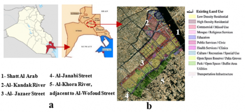
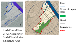
1. The location and boundaries: The proposed fabric forms part of the city center of Basra in southern Iraq, located on the southeastern edge between latitudes (29.5) and (31.2.0) in the north and longitudes (48.3.0) and (46.4.0), Which in turn reflects the urban identity of the city and attracts movement towards it from all parts of the city Figure 3a. It is characterized by multiple uses between residential, commercial, education, health, markets, and entertainment (Figure 3-b), the proposed area is bounded from the east by Shatt al-Arab, and from the south by Al-Wafoud Street along the Al-Khora River, while from the north it is bounded by the Al-Ashar River and the Al-Khandak River (Figure 3b). The analysis will be done through the adoption of the morphological map of the urban land-use of the city of Basra, which gives a comprehensive picture of the morphological structure, because some of the urban landscape elements deviated from their specific use due to other considerations.
Figure 3. (a) Map of the location of Basra province within Iraq, City center of Basra, (b) Boundaries and land uses for the selected part of the study
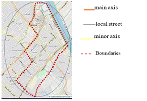
2. Axes network in urban context: In terms of morphology, the streets are the most stable element than other urban elements, it provides greater resistance to the process of transformation over time than blocks and buildings that are more susceptible to transformation [35, 36]. The study area is characterized in general by its networked tissue, according to the functional classification, and it has a clear hierarchy according to its functional importance, it begins with the main roads and ends with the local roads and consists of a set of nodes or intersections, as in the Figure 4.
3. The natural context: The formal pattern in the city of Basra - including the study area, which is an important vital part of the city center - was formed as a result of the rivers that formed the main attraction. The main rivers such as Al-Ashar and Al-Khandaq were dug perpendicular to the Shatt Al-Arab, and it was necessary to dig the secondary channels in a direction perpendicular to the first so that they form a semi-orthogonal network of graduated channels, the canal paths are left as open spaces, then the municipality transformed them into residential streets, and this gave the city the grid shape, not the organic central structure of any traditional city. Before entering into the detailed study, it is necessary to clarify:
- The open and green urban spaces, and their spatial organization within the morphological formation of the urban fabric of the city center (as natural and artificially built patches), as show in basic land use in Figure 5a.
- The network of rivers penetrating the area as natural corridors, has an effect on general morphological pattern in Figure 5b.
Figure 4. The main access of roads, as the main man-made ecological corridors
Figure 5. (a) Spatial organization of open and green urban spaces (Natural and built patches), (b) natural ecological
In general, when studying the quality of these spaces, it was found that the horizontal expansion led to a reduction in the number of natural open spaces and agricultural lands within the city center of Basra, which include ecosystems and represent their natural lung. There is a lack of commitment to laws with changes in the uses of open and green spaces for the benefit of other uses, this also led to a reduction in the area of open spaces, which is one of the important problems that appear in the city center of Basra, despite that the master plan decisions in all stages, most recently in 2014, take into account these morphological aspects. The required information was collected based on planning organizations in Basra, research, charts and satellite images.
2.3.3 Comprehensive evaluation
After analyzing the case study, and exploring the ecological indicators, the evaluation will be conducted based on the extent to which those extracted indicators are achieved or not in order to test the research hypothesis, we suggested weighted values, ranging between (2) for the achieved indicator, (1) for the partially realized indicator, and (0) for the non-existent indicator. The results of the evaluation were developed according to that described in Table 2.
Table 2. Extracted theoretical framework, with measurement and evaluation
|
The guidelines that contribute to the creation of an integrated, ecologically resilient urban landscape and increase its ability to innovate |
|||||||
|
The terms of the theoretical framework |
The evaluation |
||||||
|
Resilience Principles |
The Mechanisms |
Ecological indicators |
C |
B |
A |
||
|
(Shown as elements and relationships that achieve resilience) |
|||||||
|
Connectivity |
Ecological rhythm |
Natural as structure (activation of resilience depending on the natural formation elements) |
harmonization of successive layers of change |
Integration with the natural formation element to protect the ecosystem and visualize the coordination between different levels of change |
2 |
2 |
2 |
|
Connecting the landscape structure by integrating urban functions and uses |
2 |
2 |
2 |
||||
|
Strengthening the connection with natural spaces (rivers, hills, valleys...) |
Transparent building blocks integrated with open space or /overlooking on the river |
0 |
1 |
0 |
|||
|
Terraces on the edge of the river |
2 |
2 |
0 |
||||
|
Pedestrian sidewalk adjacent to the river |
2 |
2 |
2 |
||||
|
Availability of resilient anchorages |
2 |
2 |
0 |
||||
|
A pedestrian bridge within the axis to facilitate movement and offers a view of the river |
2 |
0 |
0 |
||||
|
Continuity of the axes and visual openness towards the natural composition element |
2 |
2 |
2 |
||||
|
Reparatory nature (Investment the potential that contribute to the revitalization resilient urban space) |
Restoring the value of the natural space / the possibility of returning to the original natural state by creating large reserve areas |
0 |
1 |
0 |
|||
|
Enhancing the natural spatial value / the possibility of creating harmony between landscape and architecture |
2 |
2 |
0 |
||||
|
Greening and shading of public space |
2 |
2 |
2 |
||||
|
Using technical solutions to conserve river water, protection, as influential element in promoting biodiversity |
2 |
2 |
0 |
||||
|
percentage of ecological rhythm |
66.67% |
66,67% |
50% |
||||
|
spatial organization Between the natural and the artificial contexts |
Activating the elements of the ecological network |
Artificial urban context |
Availability of built patch, which has an important ecological value (gardens / parks / sports fields) |
1 |
1 |
2 |
|
|
The green strip-like corridors, cut through the landscape for continuity of movement |
2 |
2 |
0 |
||||
|
Connecting built corridors, as main structural elements |
2 |
2 |
2 |
||||
|
Natural context |
Availability of natural plant patches |
2 |
2 |
0 |
|||
|
Availability of water corridor permeating urban landscape |
2 |
0 |
0 |
||||
|
Percentages of the strategic concept of the ecological network |
60% |
70% |
100% |
||||
|
Strategic activation of the interconnecting green network elements |
Availability of integrated movement axes (pedestrians, bicycle transport) that facilitate movement |
0 |
2 |
0 |
|||
|
Availability of a linear green space adjacent to the river that enhances connection with river and movement with axes |
0 |
0 |
2 |
||||
|
Pedestrian paths interconnected with recreational spaces/ or with movement axes and transport nodes |
2 |
2 |
2 |
||||
|
Percentages of the concept of strategic activation of the green network elements |
33.33% |
66.67% |
66.67 |
||||
|
Percentages of spatial organization |
50% |
68.75% |
87.50% |
||||
|
Total percentages of connectivity principle |
60% |
67.50% |
65% |
||||
|
The guidelines that contribute to the creation of an integrated, ecologically resilient urban landscape and increase its ability to innovate |
|||||||
|
The terms of the theoretical framework |
The evaluation |
||||||
|
Resilience Principles |
The Mechanisms |
Ecological indicators |
|||||
|
(Shown as elements and relationships that achieve resilience) |
C |
B |
A |
||||
|
spatial diversity (Continuing innovation and long-term resilience) |
Diversification of the general pattern formation |
Grid organization - square or rectangle |
2 |
0 |
2 |
||
|
Network-linear organization )The most acceptable change( |
0 |
2 |
0 |
||||
|
Organic organization/ Identical to local topography |
0 |
0 |
0 |
||||
|
Percentages of diversification of the general pattern formation |
33.33% |
33.33% |
33.33% |
||||
|
Ecosystem Support |
Diversity of added ecosystem services |
Providing service (food, water, natural resource productivity), organizing services (air filtration, climate regulation operations), supporting services (food recycling operations,providing habitat |
0 |
0 |
0 |
||
|
Heterogeneity in spatial patterns |
Heterogeneity in the shape of urban patches |
0 |
0 |
2 |
|||
|
Heterogeneity in urban patch size (large and small) |
0 |
0 |
2 |
||||
|
Heterogeneity in the characteristics of urban landscape corridors |
1 |
2 |
2 |
||||
|
Percentages of ecosystem support mechanism |
12.50% |
25% |
75% |
||||
|
Total percentages for diversity principle |
21.43% |
28.57% |
57% |
||||
|
performance efficiency |
Ecological inclusion to simulate |
The green space mixed with the roofs and facades of the built structures |
Not available for all indicators |
Not available for all indicators |
Not available for all indicators |
||
|
Nature's Self System |
Using shading techniques in buildings and urban spaces |
||||||
|
Determining the carrying capacity within the ecological limits |
|||||||
|
Using environmental standards / building materials that are recyclable, maintainable and long-life |
|||||||
|
Energy Efficiency |
Using advanced technology to generate energy more sustainably |
||||||
|
Redundancy (Multiple redundancy spaces that support urban biological components and provide some kind of failure insurance) |
Duplicate pattern / duplicate green patches and public places |
0 |
0 |
2 |
|||
|
Duplicate of relationships with context /A formal model similar to the functional state of the street |
0 |
1 |
1 |
||||
|
Total percentages |
0% |
25% |
75% |
||||
|
Modularity (Increased ability to self-organize in spatial patterns when exposed to crises) |
Connectivity of pathways (waterway and movement corridor) with context to enhance the ability of spatial patterns to self-organize |
1 |
1 |
1 |
|||
|
The spatial distribution of nodes and intersections of urban landscape |
2 |
2 |
2 |
||||
|
Hierarchy for corridors (waterway / movement corridor) |
2 |
2 |
2 |
||||
|
Total percentages |
62.50% |
62.50% |
87.50% |
||||
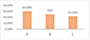
|
The Percentages of the final evaluation |
43.24% |
50% |
60% |
||||
|
Note 1: The weight assigned to the impact of each indicator is as: (2) the achieved indicator, (1) the partially realized indicator, (0) for the non-existent indicator. |
|||||||
|
Note 2: The statistical equation to standardize the values of the indicators (percentage relative frequency) |
|||||||
3.1 Configurational analysis indicators
By measuring the network of axes and their accessibility, there was a discrepancy in the results according to the axes, as follows:
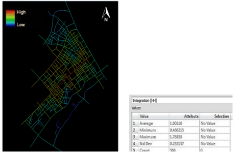
(1) Axial integration: The measurement indicator achieved an average value of (1), and the highest integration value of the measurement indicator was (1.78), and it became clear from the indicator that the main central axes are strong, which is what distinguishes them in the axial analysis map with strong colors and that the value of integration decreases as we move away from the central axes, but it is still relatively high, as shown in Figure 6a.
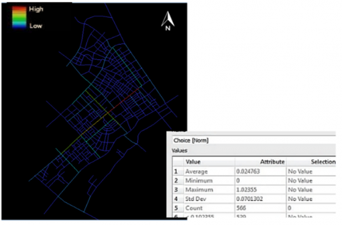
(2) Axial Choice: The results of the related analysis showed that the average value of the scale was (0.024), and the highest value was (1.02). The high values of the movement also appear in the central axes and gradually decrease away from the center, Figure 6b.
(3) The connectivity: the connectivity rate was 3,607, and the values ranged between (1-19), And that the axes with high connectivity values achieved the values (9-19), which indicate that most of the urban fabric of the study area has direct and connected streets
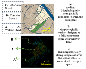
Through the above configurational analysis, it was found, in general, that two types of axes network: a strong axes that is comprehensively integrated with the fabric (that appears in strong colors), and a weak axes (less integrated), by matching the spatial organization map of urban spaces with the map of axial integration of the axes, we find (morphologically strong axes, but they are isolated from the open space), and (medium to morphologically weak axes, contact with the open space). To complete the research procedures and for made the evaluation, we have selected three axes as research samples, with its different morphological, functional and ecological characteristics to test resilience in relating to open and green spaces, then explore the relationship between resilience and urban landscape from a morphological perspective, Figures 7, 8 shows the location of those samples in the overall urban fabric and their general characteristics.
It is noted in the figures above that the streets with the highest values of integration and choice mean that these axes are the most used, visible, and characterized by their straightness, and are considered network hubs that enter the urban fabric of the city, which helps the spread of commercial uses along these axes with the absence of open space, these axes link the urban fabric to each other, as well as link the central axes of the city to the subsidiary axes. On the contrary, the peripheral axes adjacent to the rivers are connected to the green /open space are fully or partially.
Figure 6a. The Axial Integration. Red color indicates high integration (Integration Core), Blue indicates high Segregation (Segregation Core)
Figure 6b. The Axial choice. Red color indicates high integration (Integration Core), Blue indicates high Segregation (Segregation Core)
Figure 7. Matching between the spatial organization map of urban spaces and the axes integration map, determining the location of the research samples
Figure 8. Open and green urban spaces (Natural and built patches) intertwined with axes
3.2 Applying of ecological indicators of resilience principles within research sample
3.2.1 Detailed analysis
Based on the theoretical framework provided by the researchers, we are exploring ecological indicators, which can serve resilience in the chosen axes, with the evaluation percentage:
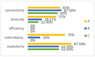
1. Connectivityindicators
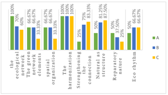
- Ecological rhythm: The results of measuring the concept showed that it achieved 50% with the A-axis, and total equal percentages (66.67%) with the B and C axes, according to the terms:
- The first main term (The nature as structure): the percentages, respectively: A (50%), B (81.25%), C (87.5%).
- The first sub-term (the harmonization of successive layers): we find a merger of the river with the three axes (A, B, C) because those axes are along the rivers and they also obtained good connectivity values in the morphological analysis, what applies to those axes applies to rivers too, as well as providing integration into urban functions and uses.
- The second sub-term (connection with natural spaces): the proportions came as follows: A (25%), B (75%), (83.33%) with C axis, where we find the transparent blocks integrated with open space in axis (B) only with a weak role for that indicator. The terraces on the edge of the river are available with the Al-Ashar River and Shatt Al-Arab in the axes (B and C). The pedestrian sidewalks adjacent to the river are available with all samples (A, B, C) because the rivers, in turn, are parallel to the roads with sidewalks adjoining its edge. As for the resilient anchorages connected to the river, we find them with the riverfront in a more organized manner (Axis B), also it was found with the Ashar River in axis (C), but it is not designed and not well managed. As for the pedestrian bridges at street level that provide a view of the river; There are several bridges at street level overlooking the Ashar River in axis (C) only, and we do not find them with the rest of the axes. We find continuity of the axes of movement and visual openness towards the river in all axes (A, B, C), as verified in the reality and within the axial choice for movement in the indicators of Configurational Analysis.
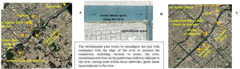
- The second main term (Reparatory nature): We verified it according to four indicators that are effective in activating the resilience of urban space; The following percentages were achieved: A (50%), B (37.5%), C (25%). We note that there are large natural reserve places, they are available within island of Dakir, which is located with the riverfront in axis (B), allowing the possibility of reconnecting with nature and enhancing ecological communication, it suffers from misuse in reality and its transformation into an unorganized commercial use. As for the connection between the landscape and the architecture, the proposed development plan under implementation with the Corniche axis (C) emphasized the strengthening of the connection with nature as an integrated system of open spaces for interactive events, and the same effect is absent in other samples. While the greening and shading of the public space is achieved in varying degrees with the axes (A, B, C), it can be observed that the elements of landscape are used with the context through the use of trees and plants, which contributes to creating open urban spaces within the urban fabric as a kind of shading to varying degrees, while there is no use of technical and natural solutions in the treatment of rainwater and the retention of river water in all samples. as in Figure 9.
- The spatial organization: The percentages were achieved (33.33%, 66.67%, 66.67) according to the terms:
- The first main term (Activating the elements of the ecological network): The highest percentage was in Axis A, which achieved a percentage of 100%, then Axis B (70%), with a decrease in the presence of those elements in Axis C (60%). The active elements of the ecological structure in the context of urban landscape have been derived from the matrix model (corridor - patch), and the presence of natural patches in the urban fabric has been observed Represented by agricultural lands and the green nursery strip along with the Al-Khora River in (Axis A) only, As for the artificial patches that include parks or gardens, they are represented by the park of Al-Khora Park as a green central space with a group of gardens extending with (A axis) as large important patches, while those patches are found less with (Axis B) in the proposed extended linear space with the development plan , as for (Axis C), it is represented by Al-Ashar Park and the green linear space that extends to part of the axis as small artificial patches at the level of the urban fabric. With regard to natural corridors, rivers are characteristic of the natural corridors of the structure of urban landscape and provide an opportunity to connect with the natural context, and they are located within the axes (A, B, C) , while the artificial corridors connected in the urban fabric include all roads and their boundaries as structural elements and are also realized With all samples (A,B,C), as for the green strip-like corridors that permeate the fabric to contribute to the continuity of movement with the axes, this element appears clearly in (Axis A) with the sidewalk adjacent to the Al-Khora River and with the extension of the street, and in (Axis B) with the extension of the street ,And in (Axis C) intermittently in some parts with the sidewalks that parallel the Ashar River or the sidewalks from the opposite side.
- The second main term (the strategic activation of green infrastructure elements): It achieved a result of three influential indicators tested with equal percentages with the two axes (A, B) amounting to 66.57, and a percentage of 33.33% with the C axis, With regard to the integrated axes that facilitate movement (transportation, pedestrians, bicycles), there is a simple application for this element through the construction of the road path in the Shatt al-Arab Corniche after Development (Axis B) to support transport functions and social interaction. As for the linear green spaces adjacent to the river that enhance communication with the river and movement with the axes, they were found morphologically achieved with the Al-Khora River within (axis A), as a linear green space extending with the axis, as the green color abounds along the river, this element is absent with the rest of the rivers because these spaces appeared as intermittent green bands spreading with the axes and not continuous spaces along the river. As for the pedestrian routes that are interconnected with the available recreational spaces and transport node, we find them in all the proposed axes (A, B, C), as there was a clear presence of pedestrian places that contribute to access to the existing spaces, as in Figure 9.
Figure 9. Percentages of the main and sub-terms of connectivity principle according to their indicators
2. The spatial diversity indicators
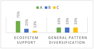
- The first main term (The diversity of the general formation of the urban fabric), we find that the square or rectangular grid organization is predominant in the urban fabric, with the appearance of the grid-linear organization with the river interface (axis B). As a result of three indicators, it achieved a rate of 33.33% in all axes.
- The second main term (Ecosystem support)
- The heterogeneity in spatial patterns, the open spaces available in the urban fabric proposed for study are adjacent to the rivers and approach the linear shape in most cases, so the formal diversity of urban areas is not available. As for the diversity of size, all the available patches are small patches in the urban fabric, green or with shaded trees, except for the presence of a large patch of green urban space extending with (A axis), while the characteristics of the corridors vary in the (B and A ) axes, as we find (a waterway and a motor corridor, pedestrians and green lane), This diversity decreases with (axis C) because it included the presence of the river and a pedestrian corridor adjacent to the rivers and the movement axis, but it was not include the green space parallel to the river, accordingly, the percentages were: A (75%), B (25%), then the C( 12.5%), Provides ecosystem services is not achieved with all sample. as in Figure 10.
Figure 10. The overall results of the spatial diversity terms
3. The ecological efficiency Indicators
It was found that the urban fabric did not include any elements that contribute to technological progress or achieve ecological integration and works to simulate nature’s own system, as the fabric lacks them in all axes.
4. The redundancy Indicators
According to two influential indicators, the A axis achieved (75%) and the B axis (25%), with regard to the multiplicity of general green patches, we find them in (the axis A) as it was clarified with the urban characteristics of that axis and in the form of natural and artificial patches that appear repeatedly along the axis, While it was found in lesser degrees and in the form of small artificial patches with the rest of the axes, as it was observed that the community gardens were sporadically present at the beginning and end of (axis B), As for (Axis C), it is designed primarily as an open urban space interspersed with green elements. As for the redundancy of relationships with context, we find them with parts of Axis (A and B) in proportion to the functional nature of the street.
5. The modularity Indicators
The results, which were linked to a set of objective and measurable criteria according to the ecological spatial patterns of the natural and artificial urban outer space showed high values in Axis A scored (87.50%), and the percentage was evenly lower in Axes B and C, as it reached (62.50%), it becomes clear that the connection with the context has been achieved for each of (rivers, roads) according to the Configurational analysis (the values of connectivity, integration and choice), It has been proven that all samples fall within the spatial distribution of street networks, with a hierarchy of corridors (roads, rivers), as well as achieving the spatial distribution of nodes and intersections. The lanes follow the hierarchy dictated by the main roads, as for the perimeter length criterion for the available green space, which in turn is limited to the (A) axis, which represents a large area of green space in the urban fabric with a circumference of more than 200 m, as we note in the map of urban land uses.
3.2.2 General analysis
The following are the final evaluation results that were reached according to analysis methods, as shown in Figures 11, 12, Table 3, which was developed by researchers as a summary of the analysis and evaluation to discuss the interrelationship between the concepts of resilience and the ecological urban space from a morphological perspective. It includes the axes that were selected for analysis with the resilience percentage of each axis resulting from the application of the indicators, also the values of configurational analysis (axial integration, connectivity) with each axis.
Figure 11. The Percentage of each principle within each axis
Figure 12. The Percentages of the final evaluation
Table 3. Summary of the results of the analysis and evaluation
|
Resilience percentage |
Indicators of morphological Configurational Analysis |
The Axis |
|
|
Connectivity |
Axial Integration |
||
|
Resilient by 60% |
Connected to the urban context with a value of (6) |
Integrated with the fabric, it achieved the second value in the space syntax analysis map according to the sequence of values of the selected samples, it appeared in yellow |
A Al-Wafoud Street |
|
Resilient by 50 % |
connectivity value (10) |
Integrated with the fabric, it appeared in green in the morphological analysis map and achieved the third value according to the sequence of values of the selected samples |
B - Corniche Street |
|
Resilient by 43% |
connectivity value (11) |
The axis achieved an average value, which was the first value according to the sequence of values of the selected samples, it appeared in orange in the morphological analysis |
C AL-Ashar Street |
Based on what was mentioned above and according to the statistical results, the results of the application of the principles were different among themselves in achieving a resilient ecological urban landscape, according to the samples (axes). On the other hand, as in Table 3, it was found that the axes with high axial integration values, which represent the important axes in the morphology of the urban fabric, and which are supposed to be ecologically impactful; it was not resilient, as in the integrated axes in the center of the city, because they came in isolation from open space (see Figure 8). While we find that (axis A), although it has the second value in morphological integration, it is ecologically resilient. This indicates that the indicators of morphological configurational analysis conflict with the concepts of resilience, which confirms the validity of the hypothesis (indicators of the resilience principles vary in achieving a resilient ecological urban landscape, and that activating resilience within those spaces requires rethinking of the traditional indicators of morphology by emphasizing that attention to the physical-ecological side of the city can reduce vulnerability and enhance resilience).
The urban landscape is mainly composed of green urban spaces and some open urban spaces with complementary landscape elements (plants, trees, etc.), all intertwined with the street network in the urban form structure as an integrated system, is characterized by: dynamism; resilient; multiple scales; It can be invested in promoting positive development in the face of changing dynamics .Resilience in its urban context represents a dynamic multi-dimensional and multi-level concept that does not always require a return to a previous state of equilibrium but will allow for the possibility of future change to continuity of structure and function to accommodate the positive consequences of changes and achieve transformations. Through the ecology of urban landscapes, cities are an ecological system that is built by human activities and supported by natural and man-made functions over time, it emphasizes on several aspects including; Relying on the idea of communicating with nature and linking with the site to give it integrative and permanence and increase ecological resilience, Emphasizing on the spatial structure and functions within that structure, which is related to biodiversity, and support the ecosystem of the place. We can present the procedural definition of the resilient ecological urban landscape as representing the green system in the formation of the urban fabric, it has the ability to deal with changes over time through the ability of its components to achieve resilience performance based on ecological factors and site-specific dynamics, and it is characterized by: rhythms of resilience, Retroactive, multiple social and ecological functions, and is based on a set of principles (connectivity, diversity, efficiency, redundancy, and modularity),which are determined what the resilient urban space should be.
Regarding the practical study, the research proved the following aspects:
(1) The morphological axial integration is contradictory with the indicators of resilience; The axes that achieved high values of resilience, actually got lower values in the configurational analysis indicators. Conversely, the axes with very high integration, which appeared in strong colors in the configurational analysis maps, were completely separate from the open space, so they have a weak resilience. This confirms that the map of the morphological structure is in a state of separation from the reality or the master plan for land uses.
(2) The morphological structure associated with nature is the most resilient, it can be said that the current time requires a rethinking of traditional morphological indicators, because the high integration, which is a traditional rule in urban morphology, does not necessarily make urban space resilient. In other words, the samples showed a high level of performance of resilience with the part strongly associated with the extension of the green and open space where most of the ecological resources are located, instead of the axes which has a high connection in the morphological indicators. All of this confirms that the axes are far from open green spaces, they are ecologically weak and do not achieve resilience, so they need to be transformed into a green space or integrated with it to strengthen it ecologically (the integration of morphological and ecological indicators in order to achieve resilience of urban space from the morphological perspective)
(3) The natural resources in the proposed urban fabric provide a vision for the establishment of green ecological urban landscapes, However, we found elements that appear to be morphologically realized, but suffer from non-serious use of urban spaces, due to the inability to control the place or think about the different levels, which led to a decrease in the values of resilience.
The research recommends:
(1) Taking advantage of the theoretical model to enhance resilience indicators on all components of urban axes as general guiding principles for urban resilience, as well as emphasis on supporting the ecosystem that provides green urban spaces to protect urban biodiversity.
(2) Attention to the morphologically strong axis and support it ecologically, this is what the research suggests directing, which can be considered the starting point for activating resilience from a morphological perspective in urban space. Under local conditions, if it is difficult to provide open space, the ecological connection can be improved through interventions to help enhance resilience, as mentioned with the indicators of efficiency.
[1] Jin, X., Wang, J. (2021). Assessing linear urban landscape from dynamic visual perception based on urban morphology. Frontiers of Architectural Research, 10(1): 202-219. https://doi.org/10.1016/j.foar.2021.01.001
[2] Liu, Z., Xiu, C., Ye, C. (2020). Improving urban resilience through green infrastructure: An integrated approach for connectivity conservation in the central city of Shenyang, China. Complexity, 2020: 1653493. https://doi.org/10.1155/2020/1653493
[3] Dhar, T.K., Khirfan, L. (2017). A multi-scale and multi-dimensional framework for enhancing the resilience of urban form to climate change. Urban Climate, 19: 72-91. https://doi.org/10.1016/j.uclim.2016.12.004
[4] Fathi, S., Sajadzadeh, H., Mohammadi Sheshkal, F., Aram, F., Pinter, G., Felde, I., Mosavi, A. (2020). The role of urban morphology design on enhancing physical activity and public health. International Journal of Environmental Research and Public Health, 17(7): 2359. https://doi.org/10.3390/ijerph17072359
[5] Salem, D. (2016). Visions for urban landscape sustainability, past, present and future. European Journal of Sustainable Development, 5(3): 419-419. https://doi.org/10.14207/ejsd
[6] Ozyavuz, M. (2012). Landscape Planning. BoD–Books on Demand.
[7] Rakhshandehroo, M., Afshin, S., Mohd Yusof, M.J. (2017). Terminology of urban open and green spaces. In 11th ASEAN Postgraduate Seminar, APGS, pp. 9-16.
[8] Aminzadeh, B., Khansefid, M. (2010). A case study of urban ecological networks and a sustainable city: Tehran’s metropolitan area. Urban Ecosystems, 13(1): 23-36. https://doi.org/10.1007/s11252-009-0101-3
[9] Keshtkaran, R. (2019). Urban landscape: A review of key concepts and main purposes. International Journal of Development and Sustainability, 8(2): 141-168
[10] Mahan, A., Mansouri, S.A. (2017). The study of “landscape” concept with an emphasis on the views of authorities of various disciplines. Journal of Bagh-e Nazar, 47: 17-28.
[11] Davies, P., Corkery, L., Nipperess, D.A., van den Berg, F., Joei, C., Bishop, M., Wilkinson, S. (2017). Urban ecology: Theory, policy and practice in New South Wales, Australia.
[12] Pickett, S.T., Cadenasso, M.L., McGrath, B. (2013). Resilience in ecology and urban design: Linking theory and practice for sustainable cities (Vol. 3). Springer Science & Business Media.
[13] Tang, Y., Gao, C., Wu, X. (2020). Urban ecological corridor network construction: An integration of the least cost path model and the in VEST model. ISPRS International Journal of Geo-Information, 9(1): 33. https://doi.org/10.3390/ijgi9010033
[14] McIntosh, J., Marques, B., Hatton, W. (2018). Indigenous cultural knowledge for therapeutic landscape design. In Handbook of research on methods and tools for assessing cultural landscape adaptation, pp. 28-52. https://doi.org/10.4018/978-1-5225-4186-8.ch002
[15] Verde, A. (2013). Resilient landscapes. From spontaneous adaptation to a post-industrial planned multi-scalar resilience. Resilient Cities.
[16] Ahern, J. (2013). Urban landscape sustainability and resilience: The promise and challenges of integrating ecology with urban planning and design. Landscape Ecology, 28(6): 1203-1212. https://doi.org/10.1007/s10980-012-9799-z
[17] Beller, E., Robinson, A., Grossinger, R., Grenier, L. (2015). Landscape resilience framework: Operationalizing ecological resilience at the landscape scale. Prepared for Google Ecology Program. A Report of SFEI-ASC’s Resilient Landscapes Program, Publication, 752: 80-92
[18] Koren, D., Rus, K. (2019). The potential of open space for enhancing urban seismic resilience: A literature review. Sustainability, 11(21): 5942. https://doi.org/10.3390/su11215942
[19] Sabokro, D., Bahrami, F., Motedayen, H. (2021). Resilience planning and design of urban rivers in the face of flood disturbances.
[20] Sazandeh, M., Faizi, M., Yazdanfar, S.A., Behzadfar, M. (2018). The typology of connectivity in landscape architecture: A review of studies on landscape connectivity (LC). Journal of Building Performance ISSN, 9(1): 2018.
[21] Alberti, M., Marzluff, J.M. (2004). Ecological resilience in urban ecosystems: Linking urban patterns to human and ecological functions. Urban Ecosystems, 7(3): 241-265 https://doi.org/10.1023/B:UECO.0000044038.90173.c6
[22] https:www.europaneurope.eu/en/exchanges/ecorhythms, accessed on 12 October 2022.
[23] Vasiljević, N., Radić, B., Gavrilović, S., Šljukić, B., Medarević, M., Ristić, R. (2018). The concept of green infrastructure and urban landscape planning: A challenge for urban forestry planning in Belgrade, Serbia. iForest-Biogeosciences and Forestry, 11(4): 491. https://doi.org/10.3832/ifor2683-011
[24] Pauleit, S., Hansen, R., Rall, E.L., Zölch, T., Andersson, E., Luz, A.C., Tosics, I., Vierikko, K. (2017). Urban landscapes and green infrastructure. In Oxford Research Encyclopedia of Environmental Science. https://doi.org/10.1093/acrefore/9780199389414.013.23
[25] Ahern, J. (2011). From fail-safe to safe-to-fail: Sustainability and resilience in the new urban world. Landscape and Urban Planning, 100(4): 341-343. https://doi.org/10.1016/j.landurbplan.2011.02.021
[26] Marcus, L., Colding, J. (2014). Toward an integrated theory of spatial morphology and resilient urban systems. Ecology and Society, 19(4): 55. https://www.jstor.org/stable/26269695
[27] Salat, S., Bourdic, L. (2012). Urban complexity, efficiency and resilience. Energy Efficiency—A Bridge to Low Carbon Economy; Morvaj, Z., Ed, 25-44.
[28] Tawil, M., Reicher, C., Jafari, M., Baeumer, K. (2016). Assessment of public space efficiency in relation to spatial development in Amman: Exploring indicators to sustainable models of future city life. Sustainable Development, 9(3): 104. https://doi.org/10.5539/jsd.v9n3p104
[29] Thomson, G., Newman, P. (2021). Green infrastructure and biophilic urbanism as tools for integrating resource efficient and ecological cities. Urban Planning, 6(1): 75-88. http://doi.org/10.17645/UP.V6I1.3633
[30] Senosiain, J.L. (2020). Urban regreeneration: Green urban infrastructure as a response to climate change mitigation and adaptation. International Journal of Design & Nature and Ecodynamics, 15(1): 33-38. http://doi.org/10.18280/ijdne.150105
[31] Gharai, F., Masnavi, M.R., Hajibandeh, M. (2018). Urban local-spatial resilience: Developing the key indicators and measures, a brief review of literature. Bagh-e Nazar, 14(57): 19-32.
[32] Kharrazi, A., Yu, Y., Jacob, A., Vora, N., Fath, B.D. (2020). Redundancy, diversity, and modularity in network resilience: Applications for international trade and implications for public policy. Current Research in Environmental Sustainability, 2: 100006. https://doi.org/10.1016/j.crsust.2020.06.001
[33] Hemmati, M. (2015). Resilience: A design approach in chaotic environment. MANZAR, the Scientific Journal of landscape, 7(32): 74-81.
[34] El-Darwish, I.I. (2022). Enhancing outdoor campus design by utilizing space syntax theory for social interaction locations. Ain Shams Engineering Journal, 13(1): 101524. https://doi.org/10.1016/j.asej.2021.06.010.
[35] van Nes, A., Yamu, C. (2017). Space Syntax: A method to measure urban space related to social, economic and cognitive factors. In The virtual and the real in planning and urban design, pp. 136-150. https://doi.org/10.4324/9781315270241-10
[36] Zehawi, R.N., Hameed, A.H. (2022). The impact of urban growth pattern on local road network: A system dynamics study. International Journal of Design & Nature and Ecodynamics, 17(2): 221-231. https://doi.org/10.18280/ijdne.170208