Hussein A. Al-Ansari![]() | Ahmed S. Al-Khafaji*
| Ahmed S. Al-Khafaji*![]()
© 2024 The authors. This article is published by IIETA and is licensed under the CC BY 4.0 license (http://creativecommons.org/licenses/by/4.0/).
OPEN ACCESS
Vitality is a sustainable concept that enhances survival and life, distinguishes successful cities from their counterparts, accommodates various events, and generates an active public life. The research highlights the role of safety and security in achieving the vitality of urban space. Therefore, the research problem was the lack of clarity of the safety and security factors and indicators that enable us to create a vibrant and sustainable urban space. Accordingly, the aim of the research in the conceptual framework was to identify these factors and indicators and explain their role in achieving vital space. This was achieved by following the descriptive approach as well as analyzing the data of the study area (Al-Mutanabbi neighborhood space in the city of Kufa, Iraq) using geographical information systems. The research assumed that there are five factors related to safety and security that greatly influence the vitality of urban space. These factors are as follows (traffic safety, protection from crime, control of public space, density, and accessibility). These factors affect people’s use of urban space and the duration of residence there. It controls the density of users, as well as providing the opportunity to practice various community activities and enjoy public life within the space. It was concluded that the vitality of urban space cannot be created unless indicators of traffic safety and accessibility within this space are activated.
urban vitality, safety and security, urban space, urban density, public space control
The human dimension has been neglected in city planning for decades, while attention has been focused on absorbing the dramatic increase in traffic, as well as ideas of modernity that have ignored public spaces and the role of city space as a meeting place for residents, thus shifting from common spaces and mutual relationships to more isolated and introverted individual uses that destroy the vital tissue. The diversity and complexity of activities is therefore a common feature that needs to be made available in the city's space to be more lively with much overlap and changes occurring between different users of the city's space [1].
Vitality is an important concept in urban planning and design because it is in the interest of sustainability, discussing people's considerations and needs and supporting their health, comfort, and security. This is through a single policy of enhancing walking, cycling, and city life in general, to achieve vitality and safety [2]. The concept refers to the planning and reallocation of city spaces for more human activities, street restoration for different uses, private leisure and relaxation spaces, and cycling and walking trails [3]. Make spaces accessible and safe, provide all amenities, and be inclusive of all segments of society [4].
Meisner et al. [5] provided a conceptual framework for the eco-humanization of a contemporary city. The study's goal was to move society from one machine-controlled life to another that is more dynamic through environmental and human indicators of the standard of life. The study found that the characteristics of eco-humanity contribute to the achievement of sustainable development goals and the vitality of the place, and the use of this concept allows the building of social, environmental and cultural links for the long-term and near-term development of the city.
Li et al. [6] examined the urban vitality relationship with the built environment, in an effort to explore the effects of environmental factors based on urban vitality patterns. The study incorporated six dimensions of built environmental factors (neighbourhood attributes, urban form and function, landscape, location, and street configuration) into the quantitative regression model to systematically explore impacts. The study found that the impact of population density, community age, open space, pavement ratio, street lights, shopping and leisure density, integration, and proximity to transport are positive catalysts for urban vitality, as opposed to road density, proximity to parks, and green spaces have a negative impact on urban vitality.
Chandak and Nagpure [7] examined the impact of the COVID-19 pandemic on the city's vitality by making a comparative analysis between a compact urban structure and a pervasive urban structure and identified the impact of certain elements that together shape the city (identity, social integration, flexibility, space making). The study found that the compact urban structure was almost impossible to social distancing due to the scarcity of roads and space constraints because this structure is dense and compact, so it recorded mutations in the rate of infection spread. The pervasive urban structure was flexible and less susceptible to infection due to the availability of open spaces. It concluded that the urban structure vital to its realization must integrate elements of identity, social integration, flexibility, and space-making, which constituted a higher degree of vitality.
Rathod and Wagner [8] addressed the aspect of human comfort and psychological well-being within public spaces to create a safe and vital environment that promotes the walking and use of public places. It examined the impact of public spaces on the positive and satisfactory stimulation of human sensory systems. Human sensory experience has been used as a tool in analyzing the conditions of public urban spaces to help make appropriate design decisions.
A review of previous studies showed us that most of them focused on individual factors within the urban space, as these studies discussed them separately. We note that some of them focused on societal roles within the urban space, while others focused on the formation of these urban spaces and how to achieve the psychological aspects associated with comfort and well-being.
In this paper, we have tried to discuss and identify the effective factors whose indicators contribute significantly to shaping urban space. The research aimed to explain how to make this space a lively space that achieves all psychological aspects, as it ensures comfort and well-being for its users. It also works to enhance the human role and stimulate the presence of activities and events to achieve prosperity and community interaction. Here lies the innovative aspect of this research paper, as it summarizes how to create a vibrant urban space that can fulfill all requirements and be effective and successful.
Safety and security are enhanced when more people move and stay within the city space, city spaces are coherent and provide short walking distances, attractive public spaces and a diversity of urban jobs that increase mobility and activity and provide more eyes along space and greater incentive to follow events within public space [1, 9]. Thus, protect people from physical or psychological violence, allow them to live and exercise their daily effectiveness without threats or fear, and create a vibrant and coherent place of reassurance and psychological comfort [10, 11].
2.1 Traffic safety
Cars have swept through cities for decades and have increased their mobility significantly, representing real threats to pedestrian and cyclist traffic and increasing the rate of traffic accidents [1, 12], so studies have identified three considerations that will enhance traffic safety:
(1) Calming Traffic: It is done through vertical and horizontal means, where vertical means (speed cushions, speed pads, high crossings, high road junctions) are included. Horizontal means included (side crawl, central island narrowing) [13].
(2) traffic management: This is done through traffic control signals at junctions and crossings to avoid conflict, the use of signs to provide regulatory information such as speed limit, turn restrictions, permissible access and street names, the use of physical barriers to restrict access to certain areas, safety cameras to detect excesses and be next to or above the roadside [14].
(3) Clarity: This is done through lighting to give pedestrians, cyclists, and drivers a better night view and the columns are 4.5-6m high in pedestrian sidewalks and bike facilities. The height of the columns is 8-12 meters on the streets and the spacing of the columns is 2.5-3 times the height [14].
2.2 Protection against crime
Crime levels are one of the most important determinants of the quality of life and vitality of the place. sociologists consider that crime is linked to social and demographic factors such as income, level of education, and ethnic composition, while planners and architects associate them with design factors such as the nature of space, lighting, or directing entrances [15, 16] and studies have confirmed that planning land uses, overlapping urban functions and building design are closely related to crime [17], Natural surveillance was one of the most important considerations limiting crime. The presence of people in space and the provision of different opportunities for them, whether walking, talking, sitting, or seeing, are considered "eyes on the street" and can follow events around them. As well as removing areas that allow hiding to improve public safety, as well as good lighting that is critical to providing safety, and that space remains busy with users somewhat continuously by providing a mix of recreational, commercial, and cultural functions and services [18].
2.3 Public space control
These are certain controls that are operated to produce a safe environment that is enjoyable and accessible to the farmers in which the control indicator includes the design for speed control, and means the maximum operational speed that can be used by vehicles within space so that they do not pose a threat to human safety [13]. With increased speed, peripheral vision is severely narrowed, increasing the risk of death for pedestrians. Each (1) km/h of speed increase above the allowable limit increases the risk of death by accidents by (4-5)%, the determinant of safe speed is the level of walking, cycling, and the degree of mixing or separation between them, and vehicles, where speed is determined on highways (60 km/h) and multi-lane roads separated from bicycles (50 km/h) and within urban areas not more than (40 km/h) If the lane is shared with cyclists, the speed is 30 km/h and if shared with pedestrians, 10-15 km/h. To achieve these speeds, specific design techniques are used such as lane narrowing, narrower diagonal fairness, and signal succession [14].
2.4 Density
Studies indicate that densities reduce travel by car, increase access to destinations using the appropriate walking mode, support public transport, and provide the necessary demand for the signature of facilities and services, as high densities are critical to the vitality and security of the place and promote public life [19, 20]. This includes the Users density index (UDI) and Commercial density index (CDI).
(1) Users density index: It represents the density of users in a particular urban space and is a measure of an environment that encourages walking to reach different destinations [21]. The presence of these densities of people within space ensures a mix of use and diverse activities [22]. User density is one of the most reliable measures for measuring space vitality [23], so high-density environments are motivating pedestrian movement and space vitality, and UDI can be calculated by the following [21]:
$\mathrm{UDI}_{\mathrm{i}}=\left(\mathrm{Usrs}_{\mathrm{i}} / \mathrm{A}_{\mathrm{i}}\right) / \max \left(\mathrm{Usrs}_{\mathrm{i}} / \mathrm{A}_{\mathrm{i}}\right), 0 \leq \mathrm{UDI}_{\mathrm{i}} \leq 1$ (1)
where:
Usrsi: is the total number of users of urban space i.
Ai: is the area of urban space i.
The denominator represents the maximum value of the simplifier to normalize the indicator in order to maintain its value between (0) and (1), as this procedure allows the indicator to be space-specific and to be more appropriate for citywide comparative analyses. Therefore, UDI appreciation means that more people are using urban space, meaning that the index's value is higher [21].
(2) Commercial density index: It is a measure of how much commercial density is available in space through the presence of activities, businesses, and others. It is key to the formation of urban centers [24], where vital spaces that attract people can be distinguished by the presence of higher densities of different commercial activities than other spaces [25]. CDI can be calculated by [21]:
$\mathrm{CDI}_{\mathrm{i}}=\left(\mathrm{GFA}_{\mathrm{i}} / \mathrm{A}_{\mathrm{i}}\right) / \max \left(\mathrm{GFA}_{\mathrm{i}} / \mathrm{A}_{\mathrm{i}}\right), 0 \leq \mathrm{CDI}_{\mathrm{i}} \leq 1$ (2)
where:
GFAi: is the total floor area of commercial activity in urban space i.
Ai: is the area of urban space i.
As in UDI, the maximum value is used primarily to retain the CDI value between (0) and (1), where the higher index value refers to closer, more diversified, and more intensive business services [21].
2.5 Accessibility
An important pillar and metric in shaping a dynamic, everyone-friendly mobility system that expresses proximity, distance, and how to reach different destinations, including different uses and public transport stations. Krizek [26], Hussein and Al-Khafaji [27] are affected by the state of the transport network, mobility patterns, individual mobility routes, and the cost of travel [28]. Easy access to urban spaces is an important aspect of human well-being and an important advantage of the space site at the expense of other less accessible spaces [29, 30]. Accessibility basically depends on the distance traveled, the lower the distance the greater the accessibility to different destinations [31].
This section shows three pioneering applied examples of urban space vitality through a safety and security feature, to discuss the possibility of achieving safety and security indicators in these study situations.
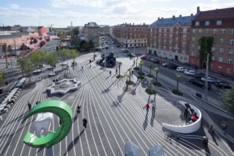
3.1 Superkilen in Norrebro district, Copenhagen
A public urban space located between residential lands in the center of Norrebro province, which is Copenhagen's most socially challenging and culturally diverse province. A car-free space based on walking and cycling with no traffic accidents, converted from a single-function space to a multifunctional, allows multiple activities and users to make it a meeting point and the area becomes more mobile, dense, and safe after experiencing crime rates. Consisting of three colorful spaces to control and indicate the types of activities that exist, it has comfort points from around the world to attract different users (Figure 1) [32, 33].
Figure 1. Design of Superkilen
Public space takes a narrow form between important main roads in the province: Tagnesvej in the north and Norrebrugade in the south, where these two roads contain public transport stations for the underground subway, and for buses and trains above the ground, providing easy access and use for all groups of society (Figure 2 and Figure 3) [33].
Figure 2. Aerial view of Superkilen
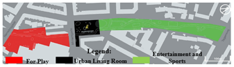
Figure 3. Black space in Superkilen space
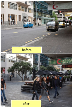
3.2 Fort in Auckland CBD
A mixed-use street has been converted into a space that combines walking, cycling, and cars and prioritizing pedestrians, increasing pedestrian volume by 54% and decreasing car volume by 25% after conversion, resulting in a more vital, mobile, and active space that ensures the diversity of users and activities. Indicative signs were placed and consistent, flat paving and uniform colors were used at the beginning and end of the pedestrian route to distinguish and indicate a change in the street environment from traditional to common pedestrian space, speed was reduced and parking was removed from the street [34]. All this has helped reduce the risk of traffic accidents and crime and has given easier control of the street and ease of moving from a traditional to a shared environment, providing easy access to the street and becoming the street with higher densities provides greater opportunities to sit, talk and see, and the area is 80% safer after change (Figure 4 and Figure 5) [14, 35].
Figure 4. Fort Street within a cluster of common streets in Auckland's CBD
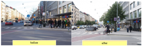
3.3 Götgatan in Södermalm District, Stockholm
A major street has been redeveloped to move from winding and narrow bike lanes to straight super bike lanes, reducing the speed of car traffic to 30 km/h, expanding the pedestrian path, and green waves of cyclists on both sides of the street have been clarified by increasing signs and countdown lights at traffic lights to control and providing safer crossings [36]. Pedestrian lanes are separated through elevated sidewalks, bike lanes are separated through bike parks and cars that act as a barrier with car traffic, this will enhance the safety of pedestrians and cyclists and enhance street vitality [13].
After reviewing experiments in urban space vitality, Superkilen's space is found to be safer and more vitality than Fort Street, Götgatan, which is the most achieved safety and security indicators. Because it is a public space free of vehicles that threaten the security and safety of other users, designed with the participation of the local population and includes different spaces with many different uses to become more connected to people and thereby foster a sense of community and attract higher densities of users (Figure 6 and Figure 7).
Figure 5. Fort street, Auckland city centre
Table 1 shows safety and security indicators of urban space vitality and measurement methods with approved standards.
Figure 6. Götgatan street shown in red
Figure 7. Götgatan street, Stockholm
Table 1. Safety and security indicators for urban space vitality
|
Characteristic |
Indicators |
Measurement Method |
Standard |
||
|
Safety and security |
Traffic Safety |
Calm traffic |
speed cushions |
Measuring Bar |
Sloping areas - elevated (75-100) mm and width (3-6) m |
|
speed pads |
Sloping areas - elevated by height (75-100) mm and width (1.6-1.9) m |
||||
|
high crossings |
Scan and Watch - Measurement Bar |
Marked and planned crossing areas for pedestrians at pavement height (100-150 mm) |
|||
|
high road junctions |
Survey and viewing |
Areas built at the height of sidewalks or less cover the entire area of intersection |
|||
|
side crawl |
Impose specific speed through the angle of transition |
||||
|
central island narrowing |
A middle island inside the street forces drivers to circle around |
||||
|
Traffic management |
Survey and viewing |
Provide traffic control signals, signage, indicative signs, physical barriers and safety cameras |
|||
|
Space Clarity |
Good lighting |
Scan and Watch - Measurement Bar |
Height of lampposts (4.5-6 m) in pedestrian sidewalks and bike facilities and (8-12 m) in streets 2.5-3 times the height |
||
|
Protection against crimes |
Detailed descriptive studies |
----- |
|||
|
Public Space Control |
Design for speed control |
A detailed outline showing increased speed with the risk of death |
60 km/h in highways |
||
|
50 km/h in physically separated lane |
|||||
|
40 km/h in urban areas |
|||||
|
30 km/h in common spaces with cyclists |
|||||
|
10-15 km/h in common spaces with pedestrians |
|||||
|
Density |
Users density index |
(UDI) |
(0-1) |
||
|
Commercial density index |
(CDI) |
(0-1) |
|||
|
Accessibility |
Distance travelled or time of arrival for space users |
(800 meters) or 10 minutes walk |
|||
The research paper relied on the descriptive analytical approach through extrapolation of the concepts and literature presented in the field of urban space vitality, as the most important effective factors and indicators that contribute to shaping it into a lively and active space were summarized. The paper relied on the latest and most pioneering sources in this scientific field. After that, the research was able to identify the effective factors that are closely related to safety and security within urban spaces, which are as follows (traffic safety, protection from crimes, control of public space, density, accessibility).
After that, measures for these factors were determined in order to test them in the study area (Al-Mutanabbi neighborhood area in the city of Kufa, Iraq). Data were collected through a field survey and observation of the reality of the situation, as well as preparing a spatial database using geographic information systems that was collected from departments. The relevant state in the city of Kufa is (Municipal Directorate, Urban Planning Directorate, Kufa Electricity Directorate, Transport and Communications Directorate, Environment Directorate).
The paper will rely on the use of spatial mathematical models to measure density rates and accessibility of space to give a clear vision of the spatial gap and how to develop proposals that contribute to the development of the study area. This methodology will contribute significantly to identifying the weak points of any urban space. This makes us address the weakness in the formation of urban space, which generally results from the absence of safety and security in urban spaces (Figure 8).
Figure 8. Research methodology
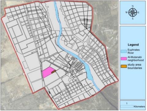
The city of Kufa enjoys different levels of urban space, the nature of its spaces is different from space to space, the majority of which is untapped to meet human needs, with most of its space specifications applying to the concept of dead space. They were spaces that dominated vehicles more than pedestrians, supported not only man's presence but only the passage and movement through them did not give a positive contribution to man, and were more repellent than attractive (Figure 9) [37-40].
Figure 9. Study area boundaries
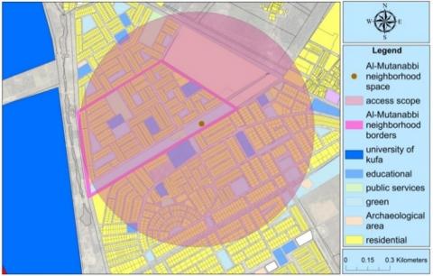
The Mutanabbi neighborhood space in the city of Kufa was elected to represent the boundaries of the study area. Space borders included a park bordered by two streets on each side. Figure 9 shows the boundaries of the study area (Figure 10 and Figure 11).
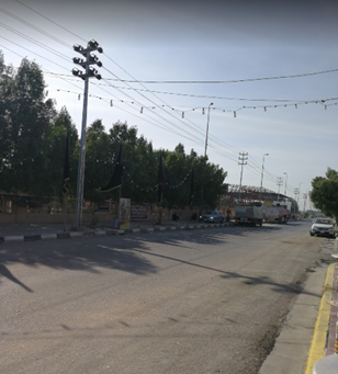
Figure 10. Al-Mutanabbi Street within the boundaries of the study area
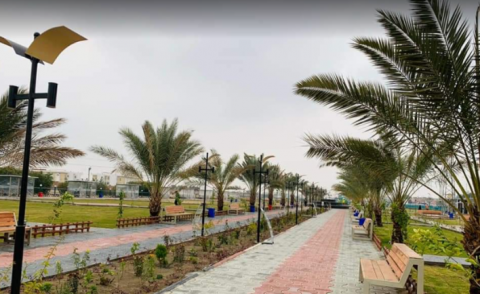
Figure 11. Al-Mutanabbi Park is within the boundaries of the study area
6.1 Traffic safety
This indicator is measured by three sub-indicators: traffic calming, traffic management, and space clarity. The first and second indicator deal with vehicle traffic primarily in the street range, and the third with space in all its ranges. It will be analyzed as follows:
(1) Calm traffic: After conducting the field survey of the Mutanabbi neighborhood space, it was found that it did not include any vertical means (speed cushions, speed pads, high crossings, high road junctions) and horizontal (side crawl, central island narrowing) to calm traffic, where space is available for any speed without any specificity or restriction, causing a real threat to human life.
(2) Traffic management: After conducting the field survey of the Mutanabbi neighborhood space, it was found to provide some signage and indicative elements for the movement of vehicles, but it lacks the physical barriers of essentially the green barrier that separates the movement of vehicles from the rest of the users, as well as the cameras whose presence is necessary for the safety and security of users.
(3) Space Clarity: Good space lighting gives better night clarity and vision and provides a sense of security for pedestrians or drivers of vehicles, and will be measured as follows:
According to field survey data and data from the Directorate of Electricity of Kufa, the pedestrian path inside the Mutanabbi neighborhood Park has a luminaire specific to the trail and the lamppost is within the permitted height (4.5-6) meters. On the street, there are no lighting poles where night vision is weak and not attractive to pedestrian traffic. Thus, the lighting did not meet the standard and was not in the required form that meets the human need to feel safe inside the street, and meets this within the park (Figure 12).
6.2 Protection against crimes
The park is often busy with users, and is free from quirky areas or facilitating hiding or dark, it is clear and visible to its owners, thus all providing a sense of security and not helping to establish crimes within the park, On the street, it gives less sense of security because it is dark and does not provide night lighting, which does not help attract high densities of people.
6.3 Public space control
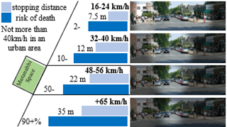
This indicator is measured by the control of vehicle speeds, where it deals with the range of urban streets, and according to the location of streets in the Mutanabbi neighborhood, the standard determines their speed by (30) km/h, but actually, after the field study, the speed at which they reach (40-60) km/h, thus exceeding the standard of neighborhood streets within the urban area, and this speed overrun leads to an increase by (50-75%) is at risk of death for pedestrians according to the Urban Area Standard Scheme as shown in Figure 12, which means that it threatens users' lives and does not meet the human need for safety and security.
Figure 12. Analysis of speed control indicator
In Figure 12, it is shown that with increased speed the peripheral vision narrows and the stop distance increases, increasing the risk of pedestrian death.
6.4 Density
It is evaluated by the User Density Index (UDI) and the Commercial Density Index (CDI), requesting maximum user Density and maximum commercial Density found within the city to be used and compared to the reality of the situation, as follows:
(1) Users density index: After conducting the field study and applying the mathematical equation of UDI according to the number of users and space area and the maximum density found within the city of Kufa, the value (UDI) has reached (0.2), meaning very little user density, because the human presence on the two streets adjacent to the park is very little or no, which adversely affects the vitality, effectiveness, and safety of space.
(2) Commercial density index: After conducting the field study and applying the mathematical equation of CDI, depending on the area of commercial activities and the total space of Mutanabbi space and the maximum commercial density found within the city of Kufa, the value (CDI) has reached (0.7), means an acceptable and stimulating commercial intensity to attract users and pedestrian movement and enhances the vitality and effectiveness of space.
Table 2 shows the measurement of user density (UDI) and commercial density (CDI) indicators.
Table 2. Density in the space of Al-Mutanabbi neighborhood
|
Space User Density |
||||
|
UDI |
Max (Usrsi/Ai) |
(Usrsi/Ai) |
Ai (hectar) |
Usrsi |
|
0.2 |
360 (U/h) |
71 (U/h) |
3.5 |
250 |
|
Commercial Density of Space |
||||
|
CDI |
Max (GFAi /Ai) |
(GFAi /Ai) |
Ai (hectar) |
GFAi (hectar) |
|
0.7 |
0.49 |
0.36 |
3.5 |
1.29 |
6.5 Accessibility
After analysis and at a distance of 800 meters, which can be traveled within 10 minutes on foot, the Metalby neighborhood space was found to be accessible and verified as an accessible residential neighborhood space level, making it more Vitality, as in Figure 13. Table 3 shows a summary of indicators for the safety and security.
Table 3 shows the results and discussion of the analysis of safety and security indicators in the Mutanabbi neighborhood space, Al Kufa City.
Figure 13. Range of access to the Mutanabbi space
Table 3. Results and discussion of the Mutanabbi Neighbourhood space analysis
|
Characteristic |
Indicators |
Results |
Discussion |
||||
|
Safety and security |
Traffic Safety |
Calm traffic |
speed cushions |
None of the horizontal and vertical means of calming traffic within space is available for any speed without specification or restriction |
Traffic in the Mutanabbi neighborhood space does not meet the human need for safety and security |
||
|
speed pads |
|||||||
|
high crossings |
|||||||
|
high road junctions |
|||||||
|
side crawl |
|||||||
|
central island narrowing |
|||||||
|
Traffic management |
The Mutanabbi neighborhood space provides some signage, indicative elements, and control signals, but it lacks the physical barriers of a green barrier that separates vehicle traffic from other users and also lacks safety cameras |
Needs physical barriers to separate vehicle traffic and other users and surveillance cameras to increase space security |
|||||
|
Space Clarity |
Good lighting |
Pedestrian light poles in Mutanabbi Park are within the permitted height (4.5-6 m), while on the street there are no lighting poles |
The standard is achieved within the park and meets the human need for vision and safety, has not been achieved on the street and does not meet the human need for vision and safety |
||||
|
Protection against crimes |
Space is often busy with users, is free from quirky areas or facilitates hiding or dark, and is clear and visible to wearers, except in the street range that does not provide night lighting, which adversely affects space vitality |
Space provides a sense of security and does not help establish crimes except for the street range which is less secure because it needs night lighting to improve visibility and attract higher densities than people |
|||||
|
Public Space Control |
Design for speed control |
(40-60) km/h |
The risk of death for pedestrians in the Mutanabbi neighborhood space (50-75%) so does not meet the human need for safety and security |
||||
|
Density |
Users density index |
0.2 |
Minimal user density does not provide a high sense of security and negatively affects space vitality |
||||
|
Commercial density index |
0.7 |
Commercial intensity is acceptable and affecting positively the vitality of space |
|||||
|
Accessibility |
Accessible within a distance of (800m) which can be traveled within 10 minute walk |
It can be accessed by the Mutanabbi neighborhood and by (76%) of the area of the other neighborhood, providing access to users |
|||||
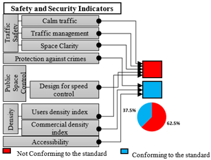
Figure 14. Safety and security indicators analysis of the Mutanabbi Neighbourhood space
Figure 14 shows what are the indicators that can achieve safety and security standards in the Mutanabbi neighborhood space, as it shows the possibility or non-possibility of the space responding to human security and safety and its impact on the level of vitality of the urban space.
This paper concluded that safety and security of urban space is a basic requirement that must be achieved by meeting the relevant factors, which the research has outlined by deriving them within the conceptual framework of the research, as the research established quantitative measures with a spatial dimension that greatly help in identifying weak points in Study area (Al-Mutanabbi neighborhood). The research found that most of the factors and indicators in the study area were not achieved, especially the traffic safety factor and car speed control, as this factor caused a clear weakness in users not having good access to the space, which negatively affected the density rate. The lack of control over the speed of vehicles imposed a real threat on the lives of urban space users and limited their presence.
The research found that the street area in the Al-Mutanabbi neighborhood lacks speed limiters, as they are available for high speeds that threaten the security and safety of users. The space also lacks surveillance cameras that help increase its safety in order to provide more opportunities for the presence of residents. From here, the research concluded that the density factor and its related indicators are decisive and important, because they determine the rate of effective human presence necessary for interaction and activities. The appropriate density rate imposes control over the urban space, as it serves as a natural protection for the place and gives it the necessary vitality.
What was previously presented in the theoretical and practical frameworks leads us to the necessity of studying the requirements of urban design for urban space. This factor is in direct contact with the vitality of urban space, as there could be future research that sheds light on the importance of urban design and its role in creating a vital urban space, which is characterized by important human activity and activities. The research also recommends studying the relationship of urban spaces with land uses, as well as studying the concept of human psychological comfort, in order to reach new indicators and standards that contribute to human safety and security and thus increase the vitality of space.
[1] Gehl, J. (2010). Cities for People. Island Press.
[2] Almahmood, M., Gulsrud, N.M., Schulze, O., Carstensen, T.A., Jørgensen, G. (2022). Human-centred public urban space: Exploring how the ‘re-humanisation’ of cities as a universal concept has been adopted and is experienced within the socio-cultural context of Riyadh. Urban Research & Practice, 15(2): 1-24. https://doi.org/10.1080/17535069.2018.1539512
[3] Marušić, B.G., Nikšič, M., Coirier, L. (Eds.) (2010). Human Cities: Celebrating Public Space. Published by Stichting Kunstboek, France, 21-25.
[4] Cabannes, Y., Douglas M., Padawangi., R. (2018). Cities by and for the People. Amsterdam University Press, 13-40. https://doi.org/10.1515/9789048536252-004
[5] Meisner, T.N., Kovalev, N.A., Lyashenko, N.V., Lepikhova, V.A. (2019). The ecologization and humanization concept of a modern city in the transition of society from industrialism to humanism. EurAsian Journal of BioSciences, 13(2): 1659-1665.
[6] Li, X., Li, Y., Jia, T., Zhou, L., Hijazi, I.H. (2022). The six dimensions of built environment on urban vitality: Fusion evidence from multi-source data. Cities, 121: 103482. https://doi.org/10.1016/j.cities.2021.103482
[7] Chandak, N.S., Nagpure, H.P. (2021). Re-establishing the relationship between urban structure & humanizing aspects of Indian cities after the COVID-19 pandemic: The case of Delhi, India. Cities People Places: An International Journal on Urban Environments, 5(1): 51. http://doi.org/10.4038/cpp.v5i1.51
[8] Rathod, D., Wagner, C. (2021). The condition of public space: The role of sensory experience design. In XXVIII International Seminar on Urban: Urban Form and the Sustainable Prosperous City, Glasgow, Scotland.
[9] Abdulameer, H.N., Al-Jaberi, A.A., Al-Khafaji, A.S., Alrobaee, T.R., Al-Ansari, H.A. (2024). Evaluating of urban space vitality: The role of safety, security, and urban planning in the religion center of Kufa city, Iraq. International Journal of Design & Nature and Ecodynamics, 19(1): 155-167. https://doi.org/10.18280/ijdne.190118
[10] Timmer, V., Seymoar, N.K., (2005). International centre for sustainable cities. The livable city: World urban forum 2006. Vancouver Working Group Discussion Paper. Western Economic Diversification Canada, 48-50.
[11] Al-Ansari, H.A., Al-Khafaji, A.S. (2023). Enhancing public health through sustainable urban design: an examination of transportation and green space integration. Journal of Urban Development and Management, 2(2): 104-114. https://doi.org/10.56578/judm020205
[12] Al-Abayechi, Y.F., Al-Khafaji, A.S. (2023). Forecasting the impact of the environmental and energy factor to improve urban sustainability by using (SEM). Civil Engineering Journal, 9(10): 2554-2567. https://doi.org/10.28991/CEJ-2023-09-10-013
[13] Abu Dhabi Vision 2030. (2016). Urban street design guide - Abu Dhabi. Abu Dhabi Urban Planning Council.
[14] NACTO and GDCI. (2016). Global Street Design Guide. Washington: Island Press.
[15] Nubani, L., Wineman, J. (2005). The role of space syntax in identifying the relationship between space and crime. In Proceedings of the 5th Space Syntax Symposium on Space Syntax, Delft, Holland, pp. 1-10.
[16] Alrobaee, T.R., Al-Khafaji, A.S., Al-salam, N.A., Al-jaberi, A.A. (2023). The safer city: A new planning perspective for the traditional city development. International Journal of Safety and Security Engineering, 13(1): 139-149. https://doi.org/10.18280/ijsse.130116
[17] LaRue, L.H. (1974). Defensible space, by Oscar Newman. Washington and Lee Law Review, 31(3): 809.
[18] Colquhoun, I. (2004). Design out crime: Creating safe and sustainable communities. Crime Prevention and Community Safety, 6: 57-70. https://doi.org/10.1057/palgrave.cpcs.8140201
[19] Burton, E. (2002). Measuring urban compactness in UK towns and cities. Environment and planning B: Planning and Design, 29(2): 219-250. https://doi.org/10.1068/b2713
[20] Hussein, W.A., Al-Khafaji, A.S. (2023). Planning and Preservation of natural areas in urban contexts: application of biophilic approach in Kufa city. International Journal of Sustainable Development & Planning, 18(9): 2829-2837. https://doi.org/10.18280/ijsdp.180921
[21] Peiravian, F., Derrible, S., Ijaz, F. (2014). Development and application of the Pedestrian Environment Index (PEI). Journal of Transport Geography, 39: 73-84. https://doi.org/10.1016/j.jtrangeo.2014.06.020
[22] Baum, A., Harpin, R.E., Valins, S. (1975). The role of group phenomena in the experience of crowding. Environment and Behavior, 7(2): 185-198. https://doi.org/10.1177/001391657500700204
[23] Brambilla, R., Longo, G. (1977). For Pedestrians Only: Planning, Design, and Management of Traffic-Free Zones. Search Works, Watson-Guptill Publications, 204-205. https://cir.nii.ac.jp/crid/1130000797760818048.
[24] Baumont, C., Bourdon, F. (2002). Centres secondaires et recomposition économique des espaces urbains. Doctoral Dissertation, Laboratoire D'analyse et de Techniques éConomiques (LATEC).
[25] Giuliano, G., Small, K.A. (1991). Subcenters in the Los Angeles region. Regional Science and Urban Economics, 21(2): 163-182. https://doi.org/10.1016/0166-0462(91)90032-I
[26] Krizek, K.J. (2003). Operationalizing neighborhood accessibility for land use-travel behavior research and regional modeling. Journal of Planning Education and Research, 22(3): 270-287. https://doi.org/10.1177/0739456X02250315
[27] Hussein, W.A., Al-Khafaji, A.S. (2023). Integrating the biophilia concept into urban planning: A case study of Kufa city, Iraq. Journal of Urban Development and Management, 2(3): 125-134. https://doi.org/10.56578/judm020302
[28] Páez, A., Scott, D.M., Morency, C. (2012). Measuring accessibility: Positive and normative implementations of various accessibility indicators. Journal of Transport Geography, 25: 141-153. https://doi.org/10.1016/j.jtrangeo.2012.03.016
[29] Vieira, R.S., Haddad, E.A. (2015). An accessibility index for the metropolitan region of São Paulo. In the Rise of the City, Edward Elgar Publishing, 242-258. https://doi.org/10.4337/9781783475360.00018
[30] Al-Mosawy, S.K., Al-Jaberi, A.A., Alrobaee, T.R., Al-Khafaji, A.S. (2021). Urban planning and reconstruction of cities post-wars by the approach of events and response images. Civil Engineering Journal, 7(11): 1836-1852. https://doi.org/10.28991/cej-2021-03091763
[31] Song, Y., Merlin, L., Rodriguez, D. (2013). Comparing measures of urban land use mix. Computers, Environment and Urban Systems, 42: 1-13. https://doi.org/10.1016/j.compenvurbsys.2013.08.001
[32] Daly, J. (2020). Superkilen: Exploring the human–nonhuman relations of intercultural encounter. Journal of Urban Design, 25(1): 65-85. https://doi.org/10.1080/13574809.2019.1622409
[33] AlShehri, A. Case study of the public urban space in Copenhagen, Denmark. https://www.academia.edu/download/57581317/Superkilen_case_study-Abdullah_Alshehri.pdf.
[34] Vasisht, P., Karndacharuk, A. (2016). Auckland shared zones: Design solution for urban mobility in activity centres. In Proceedings of the 27th ARRB Conference, Melbourne, Victoria, Australia.
[35] Royce, B. (2017). Pedestrianised ‘Shared Spaces’ Auckland CBD an operational and safety review. In IPENZ Transportation Group Conference. https://www.tgconference.co.nz/s/Royce-Bruno-Paper-68-Pedestrianised-shared-spaces.pdf.
[36] Wikström, E., Åhl Persson, A. (2015). Observiaire och film som analysmetod för cykeltrafik: En fallstudie på Götgatan i Stockholm där omställningen till supercykelbana utreds. https://www.diva-portal.org/smash/get/diva2:826072/FULLTEXT01.pdf.
[37] Sennet, R., (2002). The Fall of Public Man. Penguin Books.
[38] Kattanh, M.A., Al-Jaberi, A.A., Abd Al-Mosawy, S.K., Al-Khafaji, A.S., Alrobaee, T.R. (2023). Estimating parking demand for commercial areas in Baghdad- Iraq. International Journal of Sustainable Development and Planning, 18(12): 3823-3829. https://doi.org/10.18280/ijsdp.181214
[39] Al-Jaberi, A.A., Al-Khafaji, A., Ahmed, S., Al-Salam, N.A., Alrobaee, T.R. (2021). The crossing as a new approach for the urban transformation of traditional cities towards the sustainability. International Journal of Sustainable Development & Planning, 16(6): 1049-1059. https://doi.org/10.18280/ijsdp.160606
[40] Al-Jaberi, A.A., Al-Khafaji, A.S., Ivankina, N.A., Al-Sawafi, M.H. (2019). The idea of pedestrian pockets as a key for successful transit-oriented development for Najaf city-Republic of Iraq. IOP Conference Series: Materials Science and Engineering, 698: 033029. https://doi.org/10.1088/1757-899X/698/3/033029