Paul Gabriel Tamelan*![]() | Doppy Roy Nendissa
| Doppy Roy Nendissa![]() | Denik Sri Krisnayanti
| Denik Sri Krisnayanti![]() | Remigildus Cornelis
| Remigildus Cornelis![]() | Elsy E. Hangge
| Elsy E. Hangge![]() | Partogi H. Simatupang | Noni Banunaek
| Partogi H. Simatupang | Noni Banunaek![]()
Copyright: ©2024 The authors. This article is published by IIETA and is licensed under the CC BY 4.0 license (http://creativecommons.org/licenses/by/4.0/).
OPEN ACCESS
Landslide disasters in Indonesia often cause significant damage to public facilities, agricultural lands, and result in human casualties. This study was conducted to deeply understand the dynamics and causes of landslides and to develop effective disaster mitigation strategies in areas vulnerable to soil movement. The focus of the research is on the rotational landslide incident that occurred on the Trans Timor National Road KM 73, Noelmina Village, Takari District, Kupang Regency, East Nusa Tenggara Province, on February 17, 2023. Through a methodological approach that includes geomorphological analysis, evaluation of hydrological conditions, and land use study, this research identifies the main factors causing the landslide, including the changeable nature of Bobonaro clay soil, increased soil saturation due to hydrological conditions, and increased water load in the basin area due to land use. The findings emphasize the importance of efficient hydrological management, careful land use planning, and strengthening the capacity of local communities in landslide disaster mitigation. Recommendations for disaster mitigation include the development of infrastructure that is resistant to soil movement, vegetation planting for slope stabilization, and community education on sustainable land use practices. This research provides a significant contribution to disaster mitigation efforts in Indonesia by highlighting an approach based on a comprehensive understanding of the causes of landslides and effective adaptation strategies.
investigation, landslide, disaster, mitigation, geomorphology, hydrology, land use
Landslides represent a critical and recurrent natural disaster globally, posing significant challenges to sustainable development, especially in regions like Indonesia, where the confluence of geographical, climatic, and anthropogenic factors exacerbates their frequency and impact. Indonesia, a country characterized by its archipelagic geography and tropical climate, experiences a high incidence of landslides, affecting both rural and urban communities across its diverse landscapes. These disasters not only cause immediate loss of life and destruction of infrastructure but also have long-term repercussions on agricultural productivity and socio-economic stability. The escalating pattern of landslide occurrences is closely linked to human activities such as deforestation, land-use changes, and improper agricultural practices, alongside natural triggers like heavy rainfall and seismic events [1-7].
The geological processes underpinning landslides involve the movement of soil or rock masses on slopes under the influence of gravity, which may be precipitated by natural vibrations or earthquakes. This dynamic earth surface process, part of the broader category of mass wasting, challenges our understanding of the natural landscape's stability and evolution. The study of these processes, from the initial detachment of material from a slope to its eventual deposition, reveals critical insights into the natural balance of forces and materials shaping the earth's surface. Landslides occur when this balance is disturbed, leading to shear failure along a plane within the soil or rock mass. This failure is often a complex interplay between the material's inherent shear strength and the external stresses applied to it, including those from natural or human-induced changes in the environment [8-15].
This research targets a comprehensive exploration of the causative factors behind landslides in Noelmina Village, Takari District, Kupang Regency, aiming to dissect the intricate web of geomorphological, soil, hydrological, and land use characteristics contributing to slope instability. The investigation focuses on the Bobonaro clay formations, known for their susceptibility to sliding, evaluating how variations in slope geometry, soil properties, rainfall patterns, and anthropogenic interventions such as land clearing since 2016 influence landslide risk. By integrating geotechnical analysis with environmental and socio-economic evaluations, this study aspires to delineate the multifactorial dimensions of landslide hazards and devise effective mitigation strategies to safeguard vulnerable communities.
Amidst a backdrop of increasing landslide incidents attributed to both natural and human factors, this research posits a hypothesis that underscores the critical interplay between Indonesia's unique environmental conditions and the expanding footprint of human activities. It hypothesizes that a strategic blend of land management practices and community-based educational initiatives can substantially mitigate the adverse effects of landslides. Through a methodological approach that employs predictive modeling to assess landslide vulnerability, incorporating both environmental and human variables, this study aims to advance our understanding of landslide dynamics and inform more resilient spatial planning and disaster management practices. The novelty of this research lies in its holistic approach to examining landslide phenomena, offering a novel perspective on integrating quantitative and qualitative methodologies to enhance the predictive accuracy of landslide vulnerability assessments and the effectiveness of mitigation measures in Indonesia's wet tropical regions.
The interaction between Indonesia's unique natural environmental conditions and the expansion of human activities, especially deforestation, land-use changes, and improper agricultural practices, increases the risk and frequency of landslides. This study hypothesizes that the implementation of strategic land management practices and community-based educational initiatives can significantly reduce the adverse effects of landslides. Utilizing predictive modeling that incorporates environmental and human variables, this study aims to deepen the understanding of landslide dynamics and provide a foundation for more resilient spatial planning and disaster management practices.
The assessment of vulnerability levels in landslide-prone areas involves a multidimensional approach, integrating geological, hydrological, and land use data along with human activities and socioeconomic factors. This methodology employs a combination of field surveys, remote sensing, and GIS technologies to systematically categorize areas based on their susceptibility to landslides. Such an integrated approach ensures a comprehensive understanding of both natural predispositions and anthropogenic impacts on landslide vulnerability.
It is essential to clarify the interaction between natural conditions, such as soil composition and slope gradient, and human factors, including changes in land use and deforestation, in determining vulnerability levels. These elements collectively contribute to the landscape's susceptibility to landslides, where natural conditions prepare the stage for potential geological movements, and human activities can mitigate or exacerbate this vulnerability.
Illustrating the practical application of this framework, case studies highlight its utility. For instance, areas with high vulnerability might include regions with steep slopes and poor vegetation cover, worsened by unsustainable agricultural practices. Conversely, areas with low vulnerability could feature gentle slopes with substantial forest cover and well-managed watershed areas, demonstrating effective land use planning and conservation efforts.
Recognizing the influence of socioeconomic factors adds another layer of depth to this assessment. Populations with limited resources are often more vulnerable due to inadequate access to early warning systems, less robust infrastructure, and a lack of alternatives to high-risk land use practices. This socioeconomic dimension emphasizes the importance of an integrated approach that combines geological assessment with community engagement and resilience building.
Variation in vulnerability across different areas could significantly enhance the understanding and communication of these assessments. If data allows, these visual aids can facilitate the identification of priority areas for intervention, supporting targeted and effective landslide risk reduction strategies.
This hypothesis reflects the research assumption linking the causative factors of landslides to potential interventions that can mitigate the risks and impacts. It is based on previous observations about the impact of human activities and natural conditions on the occurrence of landslides, as well as the importance of a multidisciplinary approach in reducing the risks of natural disasters.
In summary, this extended background section endeavors to encapsulate a broader spectrum of considerations relevant to understanding and managing landslide risks in Indonesia, setting the stage for a detailed examination of the specific case of Noelmina Village. Through a critical review of existing literature and the introduction of new research questions and methodologies, this study seeks to contribute valuable insights to the ongoing discourse on natural disaster management and resilience building in vulnerable regions.
Landslides represent intricate phenomena, shaped by a combination of geological, morphological, hydrological aspects, environmental conditions, and human interventions [16]. A myriad of elements including soil properties, geological context, climatic conditions, atmospheric dynamics, and human contributions play a role in determining landslide vulnerability [17]. Understanding the spatial distribution of landslides and their influencing factors is pivotal for assessing landslide susceptibility [18]. The process of mapping landslide susceptibility necessitates amalgamating diverse factors such as the angle and composition of slopes, seismic activities, drainage configurations, and vegetation cover [19]. The employment of logistic regression alongside fuzzy analytical hierarchy processes for assigning weights to these factors in susceptibility maps has shown effectiveness [20]. Predicting landslide movements requires considering the intricate interplay among various elements, with models like GA-LSSVM being suggested for forecasting landslide progression [21]. Studies have delved into how lithology, slope gradients, orientations, peak ground accelerations, and proximity to faults influence the occurrence of co-seismic landslides [14]. Furthermore, the utility of bivariate statistical methods in correlating landslide inventories with parameters influencing landslides for susceptibility analysis has been documented [22].
The nomenclature surrounding landslides has sparked discussion among scholars. slope movement as a more precise term to describe the downward or outward movement of slope materials under gravity's pull [23]. Myers et al. [24] introduced "mass movement" as a term that more accurately captures the essence of slope material movements compared to "landslide".
Terranova et al. [25] developed a hydrological model based on genetic algorithms to predict landslide activations, showcasing its utility in forecasting and providing early warnings for civil protection. Similarly, Santangelo et al. [26] demonstrated the efficiency of remote landslide mapping techniques using laser rangefinder binoculars and GPS, proving that geographical data gathered remotely is comparable to that collected through on-ground GPS surveys.
Cui et al. [27] focused on assessing ecological risks in landscapes using remote sensing imagery and DEM data across different timelines, showing remote sensing's potential in tracking landscape alterations over time. These studies underline the critical role of advanced technologies and methodologies in comprehending, predicting landslide events, and evaluating ecological risks due to landscape transformations.
Recent investigations have shed light on various critical aspects such as the analysis of slope stability, the impact of land use alterations, rainfall effects, and community-based mitigation strategies [27-31]. Grasping the geometric facets of landslides, including rock formations, properties of slope materials, and external influences on slope stability, is vital for understanding landslides and devising effective prevention measures [32, 33]. This geometric insight is indispensable not only for researchers but also for practitioners and policymakers in formulating strategies for landslide prevention and management [34, 35].
Hungr et al. [36] stressed the necessity of adopting a multidisciplinary approach to devise holistic solutions for mitigating landslide risks and crafting prevention mechanisms Li et al. [14], Bucknam et al. [37], and Glade et al. [38] further emphasized the multidisciplinary strategy by discussing the application of empirical models to refine rainfall thresholds that trigger landslides.
The pivotal role of rainfall as a primary catalyst for landslides, especially in tropical regions, has been explored by Chang et al. [30], Nugroho and Kristanto [39] with the latter analyzing the link between typhoon-induced landslides and critical rainfall conditions. Highlighted precipitation as a likely trigger for most landslides, underscoring the significance of rainfall in landslide initiation [31].
Shabbir et al. [40] investigated the impact of environmental changes on landslides, revealing seasonal patterns in fatal landslides and the influence of environmental factors on their occurrence (the study examined the role of citrus groves in exacerbating rainfall-induced landslide hazards, highlighting vegetation's impact on landslide events) [41].
Recent research emphasizes the necessity of comprehending landslide mechanisms and triggers, particularly highlighting rainfall's role as a primary catalyst. The adoption of a multidisciplinary approach and a deep understanding of landslides' geometric properties are essential for developing effective preventive measures and comprehensive solutions to reduce landslide disaster risks. Consequently, the body of literature on landslides suggests that embracing a holistic approach and a thorough grasp of geotechnical and environmental factors are crucial for managing the challenges and consequences of landslides.
Landslide-prone areas are characterized by specific conditions such as high average rainfall levels, steep slope angles, and the presence of waterways and springs near rivers. These areas are often fertile and extensively used for cultivation and residential purposes. However, the lack of awareness and understanding among the community regarding the vulnerability of these areas to landslides leads to inadequate preparedness for disaster mitigation, resulting in greater impacts when landslides occur [42].
In addition to the general characteristics, specific areas prone to landslides include slopes at river bends, slope bend areas, and areas traversed by fault structures. Slopes at river bends are susceptible to erosion by river flow, leading to instability. Slope bend areas, which transition from steep to gentle slopes, accumulate water from steeper parts, increasing pore water pressure and weakening soil bonds, thus triggering landslides. Areas traversed by fault structures, characterized by steep slopes and fractured rocks with numerous springs, are prone to slope instability due to disrupted rock stability caused by water seepage and vibrations [42].
The classification of soil/rock mass movements includes translational landslides, rotational landslides, block movements, rockfalls, soil creep, and debris flows. Translational and rotational landslides are the most common types in Indonesia, with debris flows causing the highest human casualties. Landslides occur when the driving force on the slope exceeds the resisting force, influenced by factors such as slope angle, water, load, and rock/soil density. The understanding of these factors is crucial for landslide susceptibility assessment and mitigation.
The references provide various methodologies and models for landslide susceptibility mapping, including frequency ratio, fuzzy logic, logistic regression, weights of evidence, and artificial neural network models. These models integrate causative factors such as elevation, slope, lithology, distance to river, precipitation, and land cover to assess landslide susceptibility. These approaches have been applied in different geographical locations, including the Himalayas, Indonesia, Ethiopia, and Portugal, demonstrating their versatility and effectiveness in assessing landslide susceptibility. These methodologies and models play a crucial role in identifying potential landslide-prone areas, providing valuable information for disaster preparedness and mitigation efforts. By considering various causative factors and employing advanced techniques such as remote sensing, GIS, and statistical analysis, researchers and authorities can effectively assess and manage landslide susceptibility, ultimately reducing the impact of landslides on communities and infrastructure.
The process of assessing landslide vulnerability adopts a comprehensive multidisciplinary approach, beginning with the identification and mapping of areas potentially susceptible to landslides through remote sensing techniques and spatial analysis. The evaluation of the geotechnical conditions of slopes, including soil composition, moisture, and structural stability, is the initial step to determine the physical vulnerability of these areas. Human factors, such as land use intensity, agricultural practices, and infrastructure development, are also analyzed to understand how human interventions could increase landslide risks. This approach is strengthened with case studies providing insights into the relationship between natural conditions and human activities causing landslides.
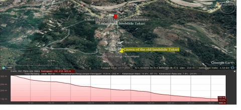
A mass movement of land in the form of a rotational landslide occurred on the Trans Timor National Road at KM 73, Noelmina Village, Takari District, Kupang Regency, East Nusa Tenggara Province. Geographically, this location is at coordinates 9°58'52.05" South Latitude and 124°05'20.92" East Longitude. Topographically, Noelmina Village is situated at an elevation ranging from 132 m to 323 meters and is an area vulnerable to ground movement.
The interaction between vulnerable natural conditions and human pressures, such as deforestation and infrastructure development without considering geological conditions, illustrates how these factors collectively increase vulnerability to landslides. Understanding this relationship is crucial for clear articulation in vulnerability assessment. Providing case studies from areas classified at various vulnerability levels illustrates the practical application of this framework, highlighting the importance of identifying and managing landslide risks in real-world contexts.
Socio-economic factors, such as population density and the adaptive capacity of local communities, are also significant in assessing vulnerability. An approach that considers socio-economic factors enables the development of inclusive and sustainable mitigation solutions. The use of visualization, such as vulnerability maps, facilitates rapid identification of high-risk areas and supports strategic planning for landslide disaster mitigation.
This integrated approach, combining the analysis of natural conditions, human influences, and socio-economic factors, along with visualization tools, offers an effective method in assessing and managing landslide risks. Through the integration of data and multidisciplinary analysis, the assessment of landslide vulnerability becomes more accurate, informative, and relevant for reducing the impact of disasters on communities and infrastructure at risk. This approach emphasizes the importance of a comprehensive understanding of landslide dynamics and targeted mitigation strategies to reduce vulnerability and enhance resilience against landslides in Noelmina Village and similar areas. The location of the Takari Landslide is shown in Figure 1.
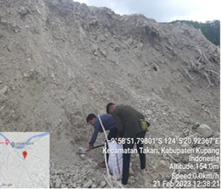
A field visit was carried out on February 21 2023 to the landslide location in Takari by the Disaster Mitigation Team formed by the Chancellor of Nusa Cendana University. The team consists of 8 experts with multidisciplinary knowledge to investigate landslides and is accompanied by assistant staff to carry out investigations at the Takari landslide location. From Kupang City to Noelmina Village, Takari District, Kupang Regency can be reached in ±1.5 hours by road with a distance of ±85 km.
In the Research Methodology segment A description of the assessment procedures or protocols implemented by the team is presented. This process begins with a comprehensive evaluation of areas potentially susceptible to landslides, incorporating the use of remote sensing techniques as well as direct field inspections. The applied protocol includes the identification of geological characteristics, soil composition, and signs of previous landslides. Data collection activities encompass technical measurements and interviews with the local community to gain an understanding of historical events and transformations in land use patterns.
Regarding safety protocols during field surveys, the team adheres to strict safety standards to ensure the security of members and the conservation of the natural environment. The use of safety equipment such as helmets, safety boots, and reflective vests is mandated. Furthermore, the team coordinates with local authorities for activity notification and to obtain the necessary permissions or guidance. Ethical aspects include respecting private property and securing consent from local residents for interviews. The team also strives to ensure that their activities do not disrupt local ecosystems or communities.
The application of these methodologies and protocols is crucial in conducting research that is not only thorough and responsible but also ensures accurate results while respecting local conditions and communities. The integration of technical, social, and ethical aspects in the research methodology underscores the complexity of evaluating vulnerability to landslides and highlights the need for a multidisciplinary approach.
Source: Google Earth, 2023
Figure 1. Location of the Takari landslide 17 February 2023
4.1 Field observation identification
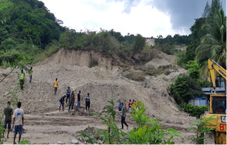
Upon conducting field investigations, it was determined that the landslide phenomenon experienced in Noelmina Village, situated within the Takari District of Kupang Regency, adhered to the rotational/slide type, specifically delineated as a curvilinear slide, as depicted in Figure 2. This event was precipitated by the translocation of soil masses comprising silt and clay dimensions, which proceeded to glide across the slip plane associated with Bobonaro clay, characterized as Expansive Clay. The arrival of the rainy season exacerbates this condition, as the notably low permeability of Bobonaro clay impedes water filtration, resulting in the overlying soil strata reaching a state of saturation. This saturation induces a reduction in friction, thereby rendering the area prone to slipperiness and instigating landslide occurrences, culminating in the downward movement of the upper soil mass. Contributory factors to landslides within Noelmina Village include the lithological characteristics, geological structures and soil taxonomy, the gradient of the terrain, alongside hydrological influences, notably the incidence of elevated rainfall.
(Source: Investigation Team Documentation 21 February 2023)
Figure 2. Rotational landslide or curved slide on the Takari landslide
(Source: Documentation by Mr. Beni Polin, February 16 2023)
Figure 3. Springs that formed at the foot of the slope before the Takari landslide occurred
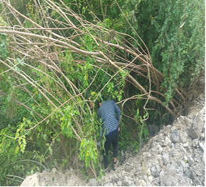
In the days leading up to the landslide event in Takari, as recounted by a local observer, Mr. Beni Polin, the area experienced rainfall, and notably, a spring emerged at the slope's base adjacent to the roadway, as detailed in Figure 3. This phenomenon suggests that the soil strata reached a saturation point, with its pores fully inundated, causing rainwater infiltration to manifest as spring runoff. The underlying stratum, composed of Bobonaro Clay - a layer impervious to water-further impedes the downward movement of rainwater. Consequently, the emergence of springs can be attributed to the saturation of soil and its minimal permeability. Such conditions serve as preliminary signs of potential soil mass movements. This is due to an increased load on the soil from infiltrating rainwater, coupled with a reduction in soil shear strength from water-induced softening, facilitating the disintegration of inter-particle bonds within the soil and its slip plane. These processes lead to the formation of increasingly slippery layers of Bobonaro silt and clay, thereby instigating landslides.
4.2 Causes of land movement/landslides
Land movement represents a geological phenomenon arising from the interplay among various factors, including morphology, geology, geological structures, hydrogeology, and land use. Triggers for such movements encompass both natural and anthropogenic processes capable of altering the stability of slopes from a state of susceptibility to actual displacement [1]). Drone-based aerial photogrammetry has revealed that the volume of material displaced during the Takari landslide amounted to 175,000 m³, with an additional 16,000 m³ affecting the road and its vicinity. Field investigations have identified multiple factors contributing to soil displacement in Noelmina Village, Takari District.
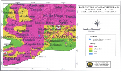
The geomorphological context of Noelmina Village, located within the Takari District, is predominantly mountainous, characterized by slopes ranging between 30º-35º and elevations spanning 130-325 meters above sea level. This region's topography features steep mountains and undulating terrains, rendering it susceptible to soil movement. The Ground Movement Forecast Map for February 2023 in the Province of East Nusa Tenggara (Geological Agency, Center for Volcanology and Geological Hazard Mitigation, 2023) classifies the Takari District as being within a medium to high potential zone for ground movement (Figure 4). The medium ground movement potential indicates that such events may occur following above-normal rainfall, particularly near river valleys, escarpments, and roadside cliffs if slope stability is compromised. Conversely, the high movement potential denotes areas where soil displacement is likely under similar rainfall conditions, with the added possibility of reactivating previous soil movements.
4.3 Condition of the soil/rock that makes up the slope
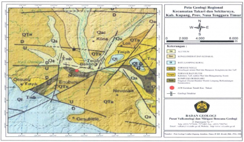
Based on the information provided from the Geological Map Sheet of Kupang-Atambua, Timor, as documented [43] accessible via the Geological Agency's website, particularly the Center for Volcanology and Geological Disaster Mitigation (2023), Figure 5, reveals the disaster site to be constituted of lithologies from the Bobonaro Complex (Tmb), Batuputih Formation (Tmpb), and the Noele Formation (QTn). The Bobonaro Complex is delineated by its composition of boulder-sized fragments within a Foraminifera-bearing clay matrix. Conversely, the Batuputih Formation is characterized by its components of calcilutite, tuff, minor marl, and arenite limestone, which is intricately associated with the Noele Formation, noted for its interbedded sandstone, conglomerate, and tuff. The geological structure at the ground movement site demonstrates considerable complexity, predominantly defined by normal faults with a west-east orientation, intersected by left-lateral faults that exhibit a north-south direction, as evidenced by the findings of [44-46].
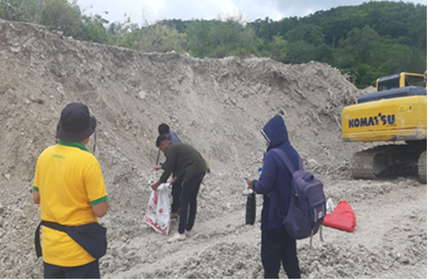
Upon the collection and laboratory analysis of soil samples from the landslide site, including both debris and native soil from the base of the landslide, the study has elucidated the physical and mechanical properties of the undisturbed soil samples retrieved from the base, pinpointing the stratum responsible for the initiation of the landslide, as well as the disturbed soil samples, representing the landslide's material aftermath. Referenced in Figure 6 and detailed in Table 1, the findings contribute a crucial insight into the landslide dynamics.
The undisturbed samples, embodying the intact geological conditions at the landslide's genesis, present a distinctive set of properties when juxtaposed against the disturbed samples, which have undergone alteration through the landslide process. The differentiation in properties between these sample types not only delineates the landslide's impact on soil stability but also emphasizes the inherent vulnerability of the site's geological makeup.
(Source: Geological Agency, Center for Volcanology and Geological Disaster Mitigation, 2023)
Figure 4. Forecast map of areas of land movement occurrence in February 2023 in Kupang Regency, Prov. NTT
(Source: Geological Agency, Center for Volcanology and Geological Disaster Mitigation, 2023)
Figure 5. Forecast map of areas where land movement will occur in February 2023 in Kupang Regency, Prov. NTT
Table 1. Soil physical and mechanical properties
|
No. |
Type of Testing |
Value |
||
|
UDS |
T. Interrupted 1 |
T. Interrupted 2 |
||
|
1 |
Water content (%) |
30.26 |
46.06 |
46.63 |
|
2 |
Specific Gravity |
2.67 |
2.61 |
2.62 |
|
3 |
Liquid Limit (%) |
73.64 |
53.53 |
54.25 |
|
Plastic Limit (%) |
15.86 |
15.85 |
15.29 |
|
|
Shrinkage Limit (%) |
7.25 |
24.64 |
32.35 |
|
|
4 |
Granule Analysis (Passing sieve no.200) (%) |
90.27 |
51.50 |
58.53 |
|
5 |
Plasticity Index (%) |
57.77 |
37.68 |
38.96 |
|
6 |
Optimum Water Content (%) |
- |
38.55 |
43.32 |
|
7 |
Maximum Dry Volume Weight (g/cm³) |
- |
0.96 |
0.90 |
|
8 |
Internal Friction Angle |
10.95 |
- |
- |
|
9 |
Cohesion, c (kg/cm2) |
0 |
- |
- |
|
10 |
Unconfined compressive strength, qu (kg/cm2) |
0.418 |
- |
- |
|
11 |
Soil permeability, K (cm/sec) |
2.6×10⁻⁷ |
1.74×10⁻⁶ |
4.77×10⁻⁶ |
Source: Analysis results, 2023
(a) Original soil sampling (UDS)
(b) Point landslide debris sampling 1
(c) Point sampling of landslide debris 2
Figure 6. Soil sampling for laboratory
The analysis aligns with existing literature, suggesting that variations in soil mechanical and physical properties significantly influence landslide susceptibility. Specifically, the study's findings resonate highlighted the critical role of soil composition and structure in landslide initiation, particularly in areas characterized by complex geological formations similar to those described by the Bobonaro Complex, Batuputih Formation, and the Noele Formation. The critical erosive shear stress is calculated as 2.8 Pa, and it has been highlighted that the breaching process of a landslide dam is influenced by the variations in soil erodibility along depth, especially for the breach initiation time [33] found that the emergence of weak regions induced by spatial variations of soil type and initial water content resulted in early triggering of landslides with smaller volumes of released mass relative to a homogeneous slope. Timing and patterns of landslide initiations were closely related to their initial dry densities, and the initiation processes were accompanied by a variation of dry density and void ratio. Additionally, the mechanical state of gravel soil in the mobilization of rainfall-induced landslides was found to be influenced by the migration of fine particles and the rearrangement of coarse-fine particles, contributing to the reorganization of the microscopic structure. In conclusion, the literature supports the assertion that variations in soil mechanical and physical properties significantly influence landslide susceptibility, particularly in areas characterized by complex geological formations. The studies provide valuable insights into the critical role of soil composition, structure, and erodibility in landslide initiation and the subsequent impact on vegetation colonization.
Furthermore, the intensive geological structure, marked by the presence of normal and left-lateral faults as identified in the region [44, 46], compounds the area's susceptibility to landslides. This study's results, therefore, not only validate the significant influence of soil properties on landslide mechanisms but also underscore the need for comprehensive geological and soil assessments in landslide-prone areas.
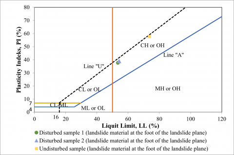
Based on laboratory analyses of undisturbed soil samples (UDS) collected from the base of the Takari landslide and adjacent disturbed areas, the debris material predominantly consisted of fine-grained soil (silt and clay). The sieve analysis revealed that the percentage of material passing through sieve No. 200 ranged from 51.50% to 90.27%, with the native soil (UDS) from the primary slip zone displaying a significantly high proportion of fine-grained soil at 90.27%. This characteristic resulted in an exceptionally low permeability rate for the soil, quantified at 2.6×10⁻⁷ cm/second, thereby hindering water infiltration. Consequently, overlying layers with higher permeability (landslide debris) became saturated upon water ingress, leading to a reduction in intergranular cohesion. This phenomenon was corroborated by shear strength tests on the UDS, indicating a cohesion value of 0 kg/cm2 and a consequent diminution in soil shear strength. This degradation in shear strength, precipitated by increased pore water pressure due to rainwater infiltration, directly contributed to landslide occurrences (T. Disturbed 1 and T. Disturbed 2). Classification of these soil samples, based on their Liquid Limit (LL) and Plasticity Index (PI) values within the Unified Soil Classification System (USCS), places them in the CH category, denoting non-organic clays with high plasticity (Figure 7).
The shear plane or sliding surface in the Bobonaro clay soil (expansive clay, UDS) manifests due to its high plasticity index value of 57.77%, significantly exceeding the 35% threshold. The inherent properties of Bobonaro clay soil, characterized by pronounced swelling and shrinkage with variations in moisture content, exacerbate this condition. During arid periods, desiccation and subsequent cracking occur as moisture evaporates from soil pores, whereas the wet season sees these cracks facilitating water infiltration, leading to soil expansion. Such hydrological dynamics at the slope's base weaken inter-particle cohesion, precipitating landslides as a result of diminished soil shear strength, rendering the soil exceedingly malleable.
In the landslide strata, composed of debris material, notably low soil density values were recorded, with disturbed soil samples 1 and 2 yielding densities of 0.96 g/cm3 and 0.90 g/cm3, respectively. This suggests an augmentation in soil porosity, thereby enhancing water permeability. Empirical evidence of this dynamic is found in the moisture content of landslide-affected disturbed soil 1, which was 46.06%, surpassing the optimal moisture content of 38.55%, and in disturbed soil 2, where the moisture content at the time of the landslide was 46.63%, exceeding the optimal moisture content of 43.32%. Such conditions, where moisture content exceeds optimal levels, lead to reduced soil density or a diminished capacity of the soil to bear loads, contributing to landslide incidents [47-51].
Figure 7. Soil classification based on the USCS system
Prolonged rainfall in the region further escalates soil moisture content. The groundwater table responds sensitively to rainwater infiltration, with elevated groundwater levels increasing pore water pressure and weakening the bonds between soil particles, thereby facilitating the downward or sliding movement of the soil mass.
4.4 Hydrological conditions
4.4.1 Location of the Takari Sub-watershed
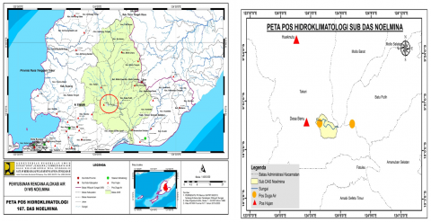
The Takari Sub-watershed, situated within the Noelmina Watershed as depicted in Figure 8, is subject to hydrological monitoring facilitated by data from BMKG Lasiana in Kupang City and BWS NT II. Within the Takari District, two proximal rainfall observation stations, namely the Hueknutu and Benu Rain Posts, are instrumental in gathering precipitation data. It is noteworthy that the Benu Rain Post corresponds to the location identified as the Kumlol Rain Post in the context of water allocation plan development for the Noelmina Watershed.
4.4.2 Ground station rain data
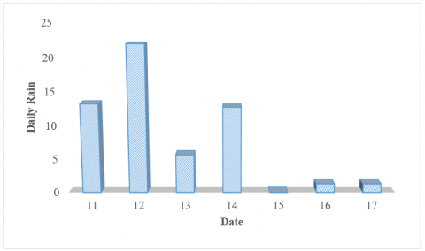
Based on Figure 8, the upstream rain post closest to the landslide location is the Hueknutu Rain Post. Rain data taken from BMKG information (No: B/KL.01.00/021/KKPN/II/2023) is obtained as in Table 2.
The search did not yield any results for the term "Ground Station Rain Data" within the provided document. Based on the image you've shared, I can provide an interpretation and synthesis of the rainfall data in the context of a research study, which can be articulated in academic language as follows:
The hydrological assessment of the Takari Sub-watershed, as delineated in Figure 8, involves meticulous analysis of precipitation data sourced from the closest upstream rain gauge, the Hueknutu Rain Post. As per the data presented in Table 2, a discernible pattern of daily rainfall during the month of February can be observed, with measurements ranging from minimal to significant levels of precipitation. Notably, the data indicates a fluctuating trend, with the highest recorded daily rainfall of 22 mm, suggesting variable weather patterns during this period. It is imperative to note the occurrence of rain on certain days where the quantity was non-quantifiable, denoted by the symbol '(-)', underscoring the limitations of measurement during certain events. The gathered data is crucial for establishing a correlation between rainfall intensity and landslide activity in the region, providing a foundation for further investigation into the hydrological triggers of slope instability.
As can be seen from Figure 9, there is unmeasured rain data and this makes it difficult for subsequent hydrological analysis. The initial moisture value (antecedent moisture conditions) can determine whether the moisture condition is in dry conditions (AMC I), normal conditions (AMC II) and wet conditions (AMC III). This can be seen in Table 3.
Table 2. Daily rain data at the Hueknutu rain post
|
February |
Daily Rain |
|
11 |
13.3 |
|
12 |
22 |
|
13 |
5.7 |
|
14 |
12.8 |
|
15 |
- |
|
16 |
1.3 |
|
17 |
1.3 |
Description: (-) there is rain but it is immeasurable
Table 3. AMC value for each class
|
Class AMC |
Amount of Rain During the Previous 5 Days |
|
|
Dry Season |
Spring |
|
|
I |
< 13 mm |
< 36 mm |
|
II |
13 mm – 28 mm |
36 mm – 53 mm |
|
III |
>28 mm |
> 53 mm |
Source: Triatmodjo, 2009
Figure 8. Location of landslides in the Takari sub-watershed in the Noelmina watershed
Figure 9. Location of landslides in the Takari sub-watershed in the Noelmina watershed
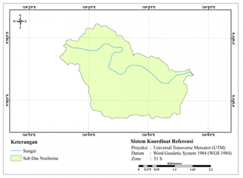
Figure 10 shows that soil moisture conditions tend to be wetter, but this cannot be concluded with certainty because there is data that was not measured on February 15 2023. To get more accurate data from conditions in the field, GPM satellite data was downloaded for 1 last week before the landslide occurred.
Figure 10. Grid for downloading satellite rainfall data in the Takari sub-catchment
For GPM rain post data in the Takari Sub-watershed area, it is multiplied by a correction factor for watersheds on Timor Island (Bam Engineering Center) as in Table 4.
Table 4. Correction factors for watersheds on Timor Island
|
Rainfall Height (mm) |
Correction Factor |
|
5 |
0.50 |
|
10 |
0.90 |
|
30 |
1.00 |
|
50 |
1.05 |
|
80 |
1.10 |
|
110 |
1.20 |
|
> 110 |
1.25 |
Based on Figure 11, it can be seen that 6 days before the landslide, the amount of rain reached 74,008 mm and after correction it became 68,142 mm. This amount of rain is higher than 53 mm. Continuous rain in the Takari sub-watershed causes soil moisture to become higher and the soil to become more saturated with water. This also results in the soil's ability to absorb water also decreasing. Continuous water pressure on this layer of soil will also influence the strength of the soil to become unstable.
Figure 11. Satellite rainfall data in the Takari sub-catchment
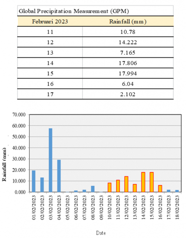
The data presented in Table 5 details the calibration of daily rainfall measurements obtained from the Global Precipitation Measurement (GPM) satellite data for a seven-day period in February 2023. The original satellite-derived rainfall values (in mm) are systematically adjusted by applying a correction factor, resulting in the corrected rainfall values. This table exemplifies the necessity for correction in satellite rainfall data, with the highest recorded uncorrected daily rainfall being 17.806 mm on the 14th, which after calibration is reduced to 16.721 mm, and the lowest recorded at 2.102 mm on the 17th, adjusted to 1.809 mm. These corrections are crucial for achieving higher accuracy in rainfall data, which has significant implications for hydrological studies and water resource management.
Table 5. Corrected rainfall based on GPM satellite data
|
February 2023 |
Rainfall (mm) |
Correction Factor |
Corrected Rainfall (mm) |
|
11 |
10.78 |
0.904 |
9.744 |
|
12 |
14.222 |
0.921 |
13.1 |
|
13 |
7.165 |
0.886 |
6.347 |
|
14 |
17.806 |
0.939 |
16.721 |
|
15 |
17.994 |
0.940 |
16.914 |
|
16 |
6.04 |
0.880 |
5.317 |
|
17 |
2.102 |
0.861 |
1.809 |
Land use
The Takari landslide incident underscores the profound impact of hilltop land clearing activities initiated since 2016 on the hydrological and geotechnical stability of the region. Notably, an ancient landslide scar at the summit forms a depression, functioning as a catchment area for rainwater and surface runoff, exacerbating the condition of the already porous basin. This particular landslide zone features dual channels extending towards the slope's base, serving as conduits for the infiltration of water from steeper inclines, thereby imposing additional strain and undermining the structural integrity of the slope's foothold.
Land clearing activities in hilly or sloped areas significantly impact the hydrological stability of the region. These initiatives, often started for development or agricultural activities, alter the landscape and soil characteristics, affecting the water cycle. Before land clearing, native vegetation plays a crucial role in absorbing rainwater and reducing surface runoff, facilitating infiltration into the soil and enhancing its capacity to retain water.
The removal of vegetation cover decreases the soil's function as an absorber and regulator of rainwater flow, leading to increased surface runoff and reduced water infiltration into the soil. The absence of vegetation increases erosion, carrying soil particles and sediment into water systems, reducing water quality and disturbing aquatic habitats, and heightens the risk of flooding due to decreased soil capacity to absorb rainwater.
Furthermore, the reduction of vegetation and root structures diminishes the mechanical strength of the soil, increasing susceptibility to landslides, particularly in areas with significant slope inclinations. Soil that becomes more porous and loses structure is more prone to water saturation, triggering soil movement or landslides, especially during or after heavy rainfall.
Land clearing impacts water availability for ecosystems and human activities by reducing water infiltration into the soil and groundwater availability. Therefore, a comprehensive environmental evaluation before land clearing and sustainable land and water management strategies, such as reforestation and terracing construction, are crucial to mitigate negative impacts and support hydrological stability.
The analysis of water accumulation dynamics in the basin area and soil mechanics indicates that without vegetation, infiltration decreases, and the potential for water accumulation increases. The loss of root structure leads to reduced soil porosity, decreasing its ability to absorb water and increasing erosion risk. Maintaining soil stability is critical to reducing flood and landslide risks, necessitating the restoration of vegetation and soil structure.
An integrated understanding of hydrology and soil mechanics is essential to address the impacts of land clearing on the hydrological and geotechnical stability of the basin area. This approach ensures the strategic design of management interventions to support environmental sustainability.
The cessation of vegetation cover due to land clearing endeavors drastically diminishes the landscape's capacity for rainwater absorption and soil structure maintenance. Vegetation is instrumental in mitigating surface runoff and water accumulation, thus safeguarding against the escalation of hydrostatic pressure within the subsoil layers, which could precipitate elevated water saturation levels [52]. During precipitation events, the augmented flow of water towards the basin amplifies the hydrostatic pressure exerted on the underlying soil strata, fostering conditions conducive to heightened water saturation.
This interplay between reduced vegetative cover and increased water saturation magnifies the susceptibility of slopes to landslides, particularly in regions with underlying vulnerabilities such as pre-existing landslide scars or depressions that serve as water collection basins. The phenomenon observed in the Takari landslide incident exemplifies the critical linkage between deforestation or land clearing practices and the destabilization of hilltop areas, underscoring the necessity for integrated land and water management strategies that prioritize the preservation of vegetation cover as a means to bolster hydrological stability and prevent soil erosion [53].
In summary, the Takari landslide incident offers a poignant illustration of how anthropogenic alterations to the natural landscape, specifically through the removal of vegetative cover on hilltops, can precipitate significant disruptions to the hydrological equilibrium of a region. These disruptions, characterized by increased surface runoff, water accumulation, and heightened hydrostatic pressure, culminate in the degradation of slope stability, thereby elevating the risk of landslides. This case study reinforces the imperative for adopting sustainable land management practices that recognize and preserve the critical role of vegetation in maintaining hydrological and geotechnical stability [54].
The dynamics of water accumulation in the basin area due to land clearing can have critical implications. The absence of vegetation leads to faster surface flow towards the basin, increasing saturation and resulting in greater hydrostatic pressure on the soil layers. The low permeability of the Bobonaro clay further complicates the issue by inhibiting water infiltration, thereby increasing the risk of saturation above the Bobonaro clay layer [55].
The presence of vegetation significantly influences the flow dynamics and hydrological processes. Vegetation affects the turbulence characteristics, shear stress, and sediment transport in channel flows [56-58]. The interaction between irregularly distributed submerged rigid vegetation and flow within a straight pool was found to be influenced by sweep and ejection events, indicating the momentum transfer between flow, bedform, and vegetated elements [59]. Additionally, the flow-retarding effects of vegetation and geotextiles on soil detachment during concentrated flow were observed, suggesting the need to treat flow shear force dissipation on soil surface roughness and roughness elements as separate processes [60].
Furthermore, the impact of vegetation complexity on subsurface flow paths has been studied, indicating that soil development, rainfall intensity, and vegetation complexity play crucial roles in shaping subsurface flow paths [61]. The presence of vegetation also affects sediment transport capacity based on slope gradients and flow discharge, as observed in laboratory experiments conducted on different underlying surfaces [15].
In addition to the physical effects, the presence of vegetation also influences the hydrogeological conditions in a given area. For instance, the investigation of hydrogeological conditions in the Manikin Dam Diversion Tunnel, Timor Island, Indonesia, revealed the presence of scaly clay and carbonate sandstone units in the study area.
In conclusion, the presence or absence of vegetation significantly impacts the dynamics of water accumulation, flow characteristics, and sediment transport in basin areas. Understanding these effects is crucial for effective land management and water resource conservation.
Based on the results of field and laboratory investigations, it can be concluded as the landslide incident in Noelmina Village, Takari District, Kupang Regency, characterized as a rotational slide within the Bobonaro clay soil domain, epitomizes the intricate interplay of geomorphological, soil, hydrological, and anthropogenic influences on land stability. This study delineates the village's predisposition to landslides, situated in mountainous terrain with slopes between 30º-35º and altitudes ranging from 130 to 325 meters above sea level. The critical threshold for slope angles instigating landslides, identified at 18° for steep slopes with horizontal planes, underscores the geomorphological vulnerability. The composition of the slopes, incorporating the Bobonaro Complex, Batuputih Formation, and Noele Formation, reveals that the landslide areas predominantly occur within the Bobonaro clay layers. These layers exhibit significant swelling and shrinkage behavior in response to moisture variability, coupled with minimal permeability. Consequently, rainwater infiltration leads to saturation, diminishing the soil's shear strength through the weakening of intergranular cohesion and elevation of pore water pressure, precipitating soil displacement.
Hydrological contributions to the landslide phenomena are highlighted by rainfall data exceeding 53 mm from local rain posts, indicating a shift from unsaturated to saturated soil conditions due to preceding light to moderate rainfall events. This transition facilitates gravitational soil movement, exacerbated by the additional load from water-induced softening. Furthermore, anthropogenic activities, specifically land clearing activities since 2016, have significantly altered the landscape. The presence of a depression at the hill's summit, a remnant of a prior landslide, becomes a receptacle for rainwater, thereby increasing saturation and the mass of the soil in the basin area. This alteration in the physical state of the soil at the slope's base acts as a catalyst for subsequent landslides. This investigation into the landslide at Noelmina Village not only elucidates the multifaceted causes behind such geophysical events but also accentuates the critical need for comprehensive land management and disaster preparedness strategies. These strategies should incorporate geomorphological and hydrological assessments alongside sustainable land use practices to mitigate future landslide risks effectively.
The research introduces valuable suggestions from reviewers aimed at enhancing the scope and depth of the paper's content, particularly concerning landslide mitigation and management. These suggestions encompass various pertinent aspects that can enrich readers' comprehension of the subject matter. In this study, our objective is to provide significant insights into understanding and confronting the challenges associated with landslide mitigation. We intend to achieve this by implementing the following recommendations, Firstly, we will focus on evaluating the effectiveness of proposed mitigation strategies. This will involve conducting a comparative analysis, drawing from relevant case studies or empirical data, to elucidate the success of these strategies in mitigating landslide risks and impacts. By doing so, we aim to offer a comprehensive understanding of the suitability of these strategies in different contexts. Secondly, we will assess the potential negative consequences of implementing mitigation recommendations. This analysis will include identifying possible compromises or side effects, accompanied by suitable mitigation strategies. Through this approach, readers will gain a balanced perspective on the implications of implementing these recommendations. Additionally, we will address the challenges associated with implementing these recommendations. This entails discussing technical, financial, and social barriers, along with proposed solutions to overcome them. By directly tackling these challenges, readers will develop a clearer understanding of the implementation process for mitigation recommendations. Finally, we will advocate for the development of advanced monitoring and early warning systems. These systems will be designed to detect early indicators of potential landslides, facilitating timely preventive actions to mitigate losses. Furthermore, we will explore the latest technology and innovative approaches to enhance the effectiveness of these mitigation efforts.
These findings have broader implications for disaster risk management and sustainable development, especially in the context of climate change, which increases the frequency and intensity of extreme weather phenomena. Knowledge of the factors affecting slope stability and landslide dynamics can guide more effective spatial planning and natural resource management, reducing community vulnerability to landslides. Additionally, improved understanding of the interactions between hydrological, geomorphological, and anthropogenic factors in triggering landslides offers crucial insights for the development of monitoring technologies and early warning systems, which can strengthen community adaptation and mitigation capacities against natural disaster risks. Lessons from this study also underscore the importance of a multidisciplinary approach in natural disaster research, integrating knowledge from various scientific fields to develop comprehensive solutions that enhance environmental and community resilience and sustainability.
This research, titled "Post-Landslide Liquefaction Analysis: A Case Study in the Kupang Regency Area, Indonesia," would not have been possible without the support and contributions from various parties. Therefore, we would like to express our deepest gratitude and appreciation to everyone who has assisted in this research process.
First and foremost, we would like to thank our Research Board who has provided guidance, advice, and constructive criticism throughout this study. Their mentorship not only shaped the framework of this research but also inspired us to pursue excellence in our work.
We are also grateful to the local government and the community in the Kupang Regency for granting permissions, access, and unwavering support while we conducted our field research. Without their hospitality and openness, the collection of data and field observations could not have been successfully executed.
[1] Attewell, P.B., Farmer, I.W. (2012). Principles of Engineering Geology. Springer Science & Business Media.
[2] Nikolaidou, S., Klöti, T., Tappert, S., Drilling, M. (2016). Urban gardening and green space governance: Towards new collaborative planning practices. Urban Planning, 1(1): 5-19. https://doi.org/10.17645/up.v1i1.520
[3] Ji, R., Wang, K., Zhou, M., Zhang, Y., Bai, Y., Wu, X., Yan, H., Zhao, Z.Q., Ye, H. (2023). Green space compactness and configuration to reduce carbon emissions from energy use in buildings. Remote Sensing, 15(6): 1502. https://doi.org/10.3390/rs15061502
[4] Popescu, M. E. (2002). Landslide causal factors and landslide remediatial options. In 3rd International Conference on Landslides, Slope Stability and Safety of Infra-Structures, pp. 61-81. CI-Premier PTE LTD Singapore.
[5] Rakhman, A.N., Maulana, F.W. (2021). Edukasi pendekatan selidik sifat fisik batuan lapuk untuk Penanganan Bencana Longsor dalam Masa Pandemi COVID-19 di RT 02 Pedukuhan Cengkehan, Wukirsari, Kapanewon Imogiri, Kabupaten Bantul. Jurnal Pengabdian Masyarakat As-Salam, 1(2): 99-108. https://doi.org/10.37249/jpma.v1i2.319
[6] Thapa, P.S., Chaudhary, S., Dasgupta, P. (2022). Contribution of integrated watershed management (IWM) to disaster risk reduction and community development: Lessons from Nepal. International Journal of Disaster Risk Reduction, 76(4): 103029. https://doi.org/10.1016/j.ijdrr.2022.103029
[7] Arfani, M. (2022). Kolaborasi pentahelix dalam upaya pengurangan risiko bencana pada destinasi wisata di desa kalanganyar sidoarjo. Jurnal Syntax Transformation, 3(1): 104-120. https://doi.org/10.46799/jst.v3i1.497
[8] Esposito, M., Palma, L., Belli, A., Sabbatini, L., Pierleoni, P. (2022). Recent advances in Internet of Things solutions for early warning systems: A review. Sensors, 22(6): 2124. https://doi.org/10.3390/s22062124
[9] Siad, L. (2001). Stability analysis of jointed rock slopes reinforced by passive, fully grouted bolts. Computers and Geotechnics, 28(5): 325-347. https://doi.org/10.1016/S0266-352X(01)00004-0
[10] Dai, F.C., Lee, C.F. (2002). Landslide characteristics and slope instability modeling using GIS, Lantau Island, Hong Kong. Geomorphology, 42(3-4): 213-228. https://doi.org/10.1016/S0169-555X(01)00087-3
[11] Qin, Z., Agarwal, V., Gee, D., Marsh, S., Grebby, S., Chen, Y., Meng, N. (2021). Study of ground movement in a mining area with geological faults using FDM analysis and a stacking InSAR method. Frontiers in Environmental Science, 9: 787053. https://doi.org/10.3389/fenvs.2021.787053
[12] Ma, K., Tang, C.A., Li, L.C., Ranjith, P.G., Cai, M., Xu, N.W. (2013). 3D modeling of stratified and irregularly jointed rock slope and its progressive failure. Arabian Journal of Geosciences, 6: 2147-2163. https://doi.org/10.1007/s12517-012-0578-6
[13] Tang, C.A., Tang, S. (2020). Applications of rock failure process analysis (RFPA) to rock engineering. Modelling Rock Fracturing Processes, Springer, Cham, 421-459. https://doi.org/10.1007/978-3-030-35525-8_17
[14] Li, J., Wang, W.D., Li, Y., Han, Z., Chen, G.Q. (2021). Spatiotemporal landslide susceptibility mapping incorporating the effects of heavy rainfall: A case study of the heavy rainfall in August 2021 in Kitakyushu, Fukuoka, Japan. Water, 13(22): 3312. https://doi.org/10.3390/w13223312
[15] Li, J., Li, B., He, K., Gao, Y., Wan, J.W., Wu, W.L., Zhang, H. (2022). Failure mechanism analysis of mining-induced landslide based on geophysical investigation and numerical modelling using distinct element method. Remote Sensing, 14(23): 6071. https://doi.org/10.3390/rs14236071
[16] Hungr, O., Evans, S.G., Bovis, M.J., Hutchinson, J.N. (2001). A review of the classification of landslides of the flow type. Environmental & Engineering Geoscience, 7(3): 221-238. https://doi.org/10.2113/gseegeosci.7.3.221
[17] Alcántara-Ayala, I., Parteli, E.J.R., Pradhan, B., Cuomo, S., Vieira, B.C. (2023). Physics and modelling of landslides. Frontiers in Physics, 11: 83. https://doi.org/10.3389/fphy.2023.1146166
[18] Erener, A., Düzgün, H.S.B. (2010). Improvement of statistical landslide susceptibility mapping by using spatial and global regression methods in the case of More and Romsdal (Norway). Landslides, 7: 55-68. https://doi.org/10.1007/s10346-009-0188-x
[19] Rahman, G., Rahman, A., Ullah, S., Miandad, M., Collins, A.E. (2019). Spatial analysis of landslide susceptibility using failure rate approach in the Hindu Kush region, Pakistan. Journal of Earth System Science, 128: 59. https://doi.org/10.1007/s12040-019-1066-0
[20] Shu, H.P., Guo, Z.Z., Qi, S., Song, D.Q., Pourghasemi, H.R., Ma, J.C. (2021). Integrating landslide typology with weighted frequency ratio model for landslide susceptibility mapping: A case study from Lanzhou city of northwestern China. Remote Sensing, 13(18): 3623. https://doi.org/10.3390/rs13183623
[21] Wen, T., Tang, H.M., Wang, Y.K., Lin, C.Y., Xiong, C.R. (2017). Landslide displacement prediction using the GA-LSSVM model and time series analysis: A case study of three gorges reservoir, China. Natural Hazards and Earth System Science, 17(12): 2181-2198. https://doi.org/10.5194/nhess-17-2181-2017
[22] Shen, L., Xu, C., Liu, L. (2015). Interaction among controlling factors for landslides triggered by the 2008 Wenchuan, China mw 7.9 earthquake. Frontiers of Earth Science, 10: 264-273. https://doi.org/10.1007/s11707-015-0517-4
[23] Brown, S., Marley, A.A.J., Donkin, C., Heathcote, A. (2008). An integrated model of choices and response times in absolute identification. Psychological Review, 115(2): 396-425. https://doi.org/10.1037/0033-295X.115.2.396
[24] Myers, P.G., Kulan, N., Ribergaard, M.H. (2007). Irminger water variability in the west Greenland current. Geophysical Research Letters, 34(17). https://doi.org/10.1029/2007GL030419
[25] Terranova, O.G., Gariano, S.L., Iaquinta, P., Iovine, G.G.R. (2015). GASAKe: Forecasting landslide activations by a genetic-algorithms-based hydrological model. Geoscientific Model Development, 8(7): 1955-1978. https://doi.org/10.5194/gmd-8-1955-2015
[26] Santangelo, M., Cardinali, M., Rossi, M., Mondini, A.C., Guzzetti, F. (2010). Remote landslide mapping using a laser rangefinder binocular and GPS. Natural Hazards and Earth System Science, 10(12): 2539-2546. https://doi.org/10.5194/nhess-10-2539-2010
[27] Cui, L., Zhao, Y.H., Liu, J.C., Han, L., Ao, Y., Yin, S. (2018). Landscape ecological risk assessment in Qinling mountain. Geological Journal, 53(S1): 342-351. https://doi.org/10.1002/gj.3115
[28] Rossi, M., Witt, A., Guzzetti, F., Malamud, B., Peruccacci, S. (2010). Analysis of historical landslide time series in the Emilia-Romagna region, northern Italy. Earth Surface Processes and Landforms, 35(10): 1123-1137. https://doi.org/10.1002/esp.1858
[29] Prastica, R., Apriatresnayanto, R., Marthanty, D. (2019). Structural and green infrastructure mitigation alternatives prevent Ciliwung river from water-related landslide. International Journal on Advanced Science Engineering and Information Technology, 9(6): 1825-1832. https://doi.org/10.18517/ijaseit.9.6.8413
[30] Chang, K.T., Chiang, S.H., Lu, F. (2007). Analysing the relationship between typhoon‐triggered landslides and critical rainfall conditions. Earth Surface Processes and Landforms, 33(8): 1261-1271. https://doi.org/10.1002/esp.1611
[31] LaHusen, S., Duvall, A., Booth, A., Grant, A., Mishkin, B., Montgomery, D. (2020). Rainfall triggers more deep-seated landslides than Cascadia earthquakes in the Oregon coast range, USA. Science Advances, 6(38). https://doi.org/10.1126/sciadv.aba6790
[32] Crozier, M.J. (1999). Prediction of rainfall-triggered landslides: A test of the antecedent water status model. Earth Surface Processes and Landforms, 24(9): 825-833. https://doi.org/10.1002/(SICI)1096-9837(199908)24:9<825::AID-ESP14>3.0.CO;2-M
[33] Chen, Y.C., Chang, K.T., Chiu, Y.J., Lau, S.M., Lee, H.Y. (2012). Quantifying rainfall controls on catchment‐scale landslide erosion in Taiwan. Earth Surface Processes and Landforms, 38(4): 372-382. https://doi.org/10.1002/esp.3284
[34] Hong, Y., Adler, R., Huffman, G. (2006). Evaluation of the potential of NASA multi‐satellite precipitation analysis in global landslide hazard assessment. Geophysical Research Letters, 33(22). https://doi.org/10.1029/2006GL028010
[35] Gordo, C., Zêzere, J.L., Marques, R. (2019). Landslide susceptibility assessment at the basin scale for rainfall- and earthquake-triggered shallow slides. Geosciences, 9(6): 268. https://doi.org/10.3390/geosciences9060268
[36] Hungr, O., Evans, S.G., Bovis, M.J., Hutchinson, J.N. (2001). A review of the classification of landslides of the flow type. Environmental and Engineering Geoscience, 7(3): 221-238. https://doi.org/10.2113/gseegeosci.7.3.221
[37] Bucknam, R.C., Coe, J.A., Chavarria, M.M., Godt, J.W., Tarr, A.C., Bradley, L.A., Rafferty, S.A., Hancock, D., Dart, R.L., Johnson, M.L. (2001). Landslides triggered by hurricane mitch in Guatemala - inventory and discussion. Report. https://doi.org/10.3133/ofr01443
[38] Glade, T., Crozier, M., Smith, P. (2000). Applying probability determination to refine landslide-triggering rainfall thresholds using an empirical “antecedent daily rainfall model”. Pure and Applied Geophysics, 157: 1059-1079. https://doi.org/10.1007/s000240050017
[39] Nugroho, N.E., Kristanto, W.A.D. (2020). Kajian tingkat risiko tanah longsor desa hargomulyo, kecamatan kokap, kabupaten kulonprogo. Jurnal Ilmiah Lingkungan Kebumian, 1(2): 9-25. https://doi.org/10.31315/jilk.v1i2.3281.g2541
[40] Shabbir, W., Omer, T., Pilz, J. (2023). The impact of environmental change on landslides, fatal landslides, and their triggers in Pakistan (2003-2019). Environmental Science and Pollution Research, 30: 33819-33832. https://doi.org/10.1007/s11356-022-24291-z
[41] Lusiana, N., Shinohara, Y. (2022). The role of citrus groves in rainfall-triggered landslide hazards in Uwajima, Japan. Water, 14(13): 2113. https://doi.org/10.3390/w14132113
[42] Samia, J., Temme, A., Bregt, A., Wallinga, J., Guzzetti, F., Ardizzone, F., Rossi, M. (2017). Do landslides follow landslides? Insights in path dependency from a multi-temporal landslide inventory. Landslides, 14: 547-558. https://doi.org/10.1007/s10346-016-0739-x
[43] Suwitodirjo, T., Tjokrosapoetro, S. (1996). Geological map of the Kupang–Atambua sheet. Timor, Center for Geological Research and Development.
[44] Tintakorn, N., Pananont, P., Mahattanachai, T., Charusiri, P. (2012). Analysis of geologic structures in the southern Mergui Basin, Andaman Sea. Bulletin of Earth Sciences of Thailand, 5(1): 68-88.
[45] Ford, M., Hemelsdaël, R., Mancini, M., Palyvos, N. (2016). Rift migration and lateral propagation: Evolution of normal faults and sediment-routing systems of the western Corinth rift (Greece). Geological Society, London, Special Publications, 439: 131-168. https://doi.org/10.1144/SP439.15
[46] Handayanto, E., Muddarisna, N., Fiqri, A. (2017). Soil Fertility Management. Brawijaya University Press.
[47] Hardiyatmo, H.C. (2006). Handling Landslides and Erosion. Gadjah Mada University Press.
[48] McKenna, J.P., Santi, P.M., Amblard, X., Negri, J. (2012). Effects of soil-engineering properties on the failure mode of shallow landslides. Landslides, 9: 215-228. https://doi.org/10.1007/s10346-011-0295-3
[49] Sorbino, G., Nicotera, M.V. (2013). Unsaturated soil mechanics in rainfall-induced flow landslides. Engineering Geology, 165: 105-132. https://doi.org/10.1016/j.enggeo.2012.10.008
[50] Bogaard, T.A., Greco, R. (2016). Landslide hydrology: From hydrology to pore pressure. Wiley Interdisciplinary Reviews: Water, 3(3): 439-459. https://doi.org/10.1002/wat2.1126
[51] Pei, P., Zhao, Y.L., Ni, P.P., Mei, G.X. (2020). A protective measure for expansive soil slopes based on moisture content control. Engineering Geology, 269: 105527. https://doi.org/10.1016/j.enggeo.2020.105527
[52] Dietrich, W.E., Perron, J.T. (2006). The search for a topographic signature of life. Nature, 439(7075): 411-418. https://doi.org/10.1038/nature04452.
[53] Montgomery, D.R., Brandon, M.T. (2002). Topographic controls on erosion rates in tectonically active mountain ranges. Earth and Planetary Science Letters, 201(3-4): 481-489. https://doi.org/10.1016/S0012-821X(02)00725-2
[54] Schuster, R.L., Highland, L.M. (2001). Socioeconomic and environmental impacts of landslides in the western hemisphere (No. 2001-276). Open-File Report 2001-276. https://doi.org/10.3133/ofr01276
[55] Fatima, I.M.D.D., Putra, D., Pranantya, P.A., Sidharno, W. (2024). Investigation of hydrogeology condition in manikin dam diversion tunnel, Timor Island, Indonesia: A case study. E3S Web of Conferences, 479: 02004. https://doi.org/10.1051/e3sconf/202447902004
[56] Loheide, S.P., Gorelick, S.M. (2007). Riparian hydroecology: A coupled model of the observed interactions between groundwater flow and meadow vegetation patterning. Water Resources Research, 43(7). https://doi.org/10.1029/2006WR005233
[57] Penna, N., Coscarella, F., D’Ippolito, A., Gaudio, R. (2020). Bed roughness effects on the turbulence characteristics of flows through emergent rigid vegetation. Water, 12(9): 2401. https://doi.org/10.3390/w12092401
[58] Kothyari, U.C., Hashimoto, H., Hayashi, K. (2009). Effect of tall vegetation on sediment transport by channel flows. Journal of Hydraulic Research, 47(6): 700-710. https://doi.org/10.3826/jhr.2009.3317
[59] Nosrati, K., Afzalimehr, H., Sui, J.Y. (2022). Interaction of irregular distribution of submerged rigid vegetation and flow within a straight pool. Water, 14(13): 2036. https://doi.org/10.3390/w14132036
[60] Knapen, A., Smets, T., Poesen, J. (2009). Flow‐retarding effects of vegetation and geotextiles on soil detachment during concentrated flow. Hydrological Processes, 23(17): 2427-2437. https://doi.org/10.1002/hyp.7360
[61] Hartmann, A., Weiler, M., Greinwald, K., Blume, T. (2021). The impact of soil development, rainfall intensity and vegetation complexity on subsurface flow paths along a glacial chronosequence of 10 millennia. Hydrology and Earth System Sciences Discussions, 1-35. https://doi.org/10.5194/hess-2021-242