Fernando Morante-Carballo | Lady Bravo-Montero* | Néstor Montalván-Burbano | Paúl Carrión-Mero
© 2023 IIETA. This article is published by IIETA and is licensed under the CC BY 4.0 license (http://creativecommons.org/licenses/by/4.0/).
OPEN ACCESS
In the American continent, the movement of tectonic plates causes seismic activity that generates earthquakes. Some countries of America are located on the western fringe of the Pacific Ring of Fire, which involves several tectonic plates, such as Nazca, Cocos, and North American, among others. This study aims to analyse the scientific production of Earthquakes in America (EiA) using Web of Science and Scopus databases, to understand the origin (first publications in the area), intellectual structure (bibliometric maps), and research trends (topics for future works). The methodology was based on: (i) criteria for database selection (reasons for selecting Scopus and Web of Science), (ii) data processing (merging databases, deleting duplicates or erroneous documents, and the selection of bibliometric software), and (iii) analysis of intellectual structure (performance of scientific publications using bibliometric maps). The EiA has greatly impacted academia since its first publication in 1861, analysing 6553 scientific publications from the western part of the Pacific Ring of Fire. It includes the most representative subduction zones in the world, with major records in the last nine years, having contributions mainly from Mexico, France, Guatemala, and Chile. Finally, the trend topics aligned to EiA are ground motion models, seismic hazards, and induced seismicity.
seismicity, bibliometric analysis, systematic review, web of science, Scopus, pacific ring of fire
The Earth's rotational dynamics influence the distribution of heterogeneities within the Earth [1]. Consequently, limitations on mantle temperatures and modelling of seismic data allow a better understanding of the Earth's dynamics [2, 3]. Seismicity can also be induced by anthropogenic activities, such as industrial activities, increasing the seismicity, intensity, and number of tectonic earthquakes [4], As well as reservoir impoundment, subsurface-surface mining, injection of fluids into subway formations, extraction of fluids and gas from the subsurface [5].
In seismology, several methodologies, such as the stochastic method, allow the simulation of the expected ground motions for a series of earthquakes with a specific magnitude and distance from the epicentre [6]. Also, the simplified procedural method evaluated the liquefaction resistance of soils. This method was developed after the 1964 earthquakes in Alaska and Japan [7]. Finally, the methods: limit analysis, Finite Element Method pushover analysis (FEM), and Nonlinear Dynamic Analysis (NDA) predicted most of the observed damage and collapse for a similar seismic effect caused by a real earthquake [8, 9].
North America (California) has had five earthquakes associated with its long San Andreas fault system [10]. One of these is the April 18, 1906 earthquake of Mw=7.8, with a hypocenter in an SW-NE trending zone crossing the Offshore San Andreas fault system west of San Francisco [11, 12]. The focus of this earthquake is associated with a right extensional step in the San Andreas fault system, a zone of ocean bed subsidence and complex normal and slip faults [13, 14], causing a moderate tsunami that resulted in a 10cm drop in sea level, many deaths and damage [15, 16].
In Central America, dehydration of the subducting oceanic crust and upper mantle promotes partial melting, leading to arc magmatism and inducing earthquakes in this trench zone [17, 18]. Consequently, since 1900, 17000 people have died from earthquakes on the volcanic front [19]. El Salvador has suffered 11 destructive earthquakes during the last 100 years, causing more than 3000 deaths [20]. Mexico has a history of 42 earthquakes with a magnitude greater than seven this century, associated with the subduction zone [21]. In the convergence zone between the Cocos and Caribbean plates, the Haiti earthquake occurred on January 12, 2010, with an Mw=7.0 on the Enriquillo fault that slipped an average of 8 mm/year and caused 230 000 human losses [22].
In South America, between latitude 0° and 45°S, the spatial distribution of earthquake hypocenters is explained by the simple model of a descending Nazca oceanic plate beneath a South American continental plate [23]. The convergent margin of the Northern Andes is a region of intense cortical deformation where large subduction earthquakes have occurred [24]. The largest instrumentally recorded earthquake in the world occurred on May 22, 1960, in Valdivia in southern Chile [25], with a magnitude Mw=9.5 [26, 27]. An earthquake occurred in Ecuador on April 16, 2016, with a magnitude of Mw=7.8, that ruptured the subduction zone boundary between the Nazca and South American plates, registering 673 fatalities [28, 29]. Table 1 summarises the major catastrophic earthquakes in the Americas.
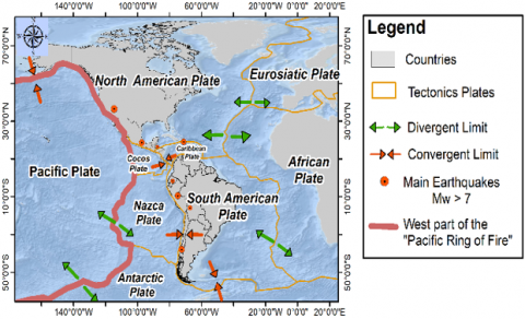
Figure 1 shows the tectonic plate boundary in the American continent and the most representative earthquakes.
Earthquakes in America (EiA) is a topic of great importance worldwide. Therefore, this work provides more information from a bibliometric approach for the knowledge of the causes and effects of earthquakes. The research question is: What are the main results, methodologies, and effects of the EiA obtained from the analysis of scientific publications?
The objective is to analyse the scientific publications of EiA of tectonic origin using WoS and Scopus databases and bibliometric analysis to assess the origin, evolution and research trends of this topic.
Figure 1. Spatial representation of catastrophic earthquakes in America and tectonic plates on the west coast of the pacific ring of fire
Table 1. Catastrophic earthquakes occurred on the west coast of the pacific ring of fire
|
Region |
Country/date |
Consequences |
Geological Reason |
Sources |
|
North America |
Northridge, USA Mw=6.7 17/01/1994 |
More than 29 deaths, 7,000 injured, and major financial losses. |
By historical geologic faults in the San Fernando Valley and conjugate reverse fault system. |
[30, 31] |
|
Pacific Coast, Mexico Mw=8.1 19/09/1985 |
Catastrophic damage to the northwest of the city and record of seismic movements. |
Subduction of the Cocos plate beneath Mexico. |
[32, 33] |
|
|
Central America |
Estrella Valley, Costa Rica Mw=7.7 22/04/1991 |
It caused 75 deaths, 560 injured and 10,000 victims. |
Associated with the North Panama Deformed Belt, a complex of thrusts and folds that has accommodated the oroclinal deformation of Panama. |
[34, 35] |
|
Nicoya, El Salvador Mw=7.6 13/01/2001 |
It caused an earthquake aftershock, 1200 deaths and 20% of the houses were damaged. |
Generated in the Benioff Wadati zones of the Cocos plate subducted with the Caribbean plate, coincident with Quaternary volcanoes. |
[20, 36] |
|
|
South America |
Valdivia, Chile Mw=9.5 22/05/1960 |
World's largest instrumentally recorded earthquake. |
Rupture zone near the subduction edge of the Nazca plate. |
[26, 37] |
|
Arequipa, Peru Mw=8.4 23/06/2001 |
It generated 450 earthquake aftershocks, 102 deaths and soil liquefaction. |
Earthquake in the coupled zone of the Nazca plate subduction along the SE of the Nazca Ridge. |
[38, 39] |
Note: Mw: Moment magnitude of earthquakes.
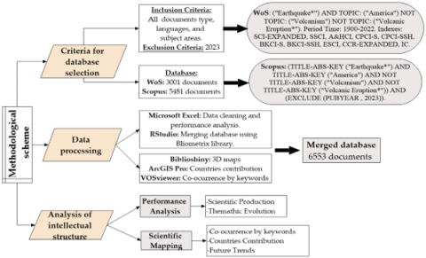
Bibliometrics is a method widely used to explore and treat large volumes of data [40], analysing the growth of a field of knowledge and its emerging areas [41]. This methodology is considered a field of research implemented in the professional-academic field because it generates a complete map of the intellectual structure of a subject [42]. The advantage of this methodology is that it comprehensively analyses a database regarding scientific production, evolution, trends, prominent authors, countries, institutions and journals [43]. Therefore, bibliometrics has been applied in several academic disciplines [44-46]. The methodology consisted of three phases: (i) criteria for database selection, (ii) data processing, and (iii) analysis of intellectual structure (see Figure 2).
Figure 2. Methodological approach
2.1 Criteria for database selection
Due to their reliability and quality, the Web of Science (WoS, launched by Clarivate Analytics, London, UK) and Scopus databases are the most widely used in bibliometric studies [47, 48]. In this study, these two databases were chosen because of i) coverage in academic disciplines, ii) accessibility and ease of data download, iii) existence of bibliometric studies with these databases, and iv) institutional access. Data was collected in June 2023 using descriptors related to the keyword Earthquakes, contained in the title, abstract and keywords, and Boolean logic functions (AND, OR), which allowed the search equation. Subsequently, the databases were combined to evaluate the evolution of studies regarding volume and impact [49]. The topic search equations for Scopus and WoS are included in Figure 2.
As inclusion criteria, all types of documents, languages and subject areas were considered because it is a topic of international relevance and intended to know its trends and progress over time [50]. The exclusion criteria considered 2023 as the current year, as well as "Volcanism" and "Volcanic Eruption*" since this study focuses on catastrophic earthquakes (Mw>6.9) produced in the western part of the Pacific Ring of Fire, the most representative subduction zones in the world, excluding earthquakes of volcanic origin. In addition, the economic, social and environmental impacts generated by these earthquakes in a given region were considered.
2.2 Data processing
This phase consisted of unifying the databases (Scopus and WoS) using the Bibliometrix package from the R software. These databases differ in download formats, scope terms, data volume and coverage policies [51]. Therefore, the databases were downloaded in BibTeX format for Scopus and plaintext for WoS for merging processing in RStudio, unifying the information from these two databases. These formats include bibliographic information, citations, abstract, keywords, and references.
After, the merged database obtained was processed using Microsoft Excel to delete duplicate, incomplete or erroneous items. The criteria used was a filter by columns of the merged database document, considering the following columns: authors name, publication year, document type, and publication title. Finally, the software used during this phase is described below:
(1) Microsoft Excel: Allows the analysis of the evolution of scientific production using the information on documents, languages, subject areas, and journals [52].
(2) RStudio 4.0.5: Open-source statistical software with an integrated development environment belonging to R [53, 54]). It was used for merging databases (WoS and Scopus) through the Bibliometrix package.
(3) Bibliometrix: Developed by Massimo Aria and Corrado Cuccurullo at the University of Naples Federico I in Italy [55]. This tool processes the information, encoding it in RStudio [56, 57]. Two functions from Bibliometrix were used: ´readfile´ to load and convert data to UTF-8 format and ´conver2df´ to extract and create a data frame for post-processing in biblioshiny (the shiny app for Bibliometrix) to generate bibliometric networks like ´thematic Evolution graph´ and ´trend topics map´.
(4) VOSviewer 1.6.19: Free software developed by the University of Leiden (Leiden, Netherlands). It allows the analysis of the intellectual structure of a topic through bibliometric maps [58, 59]. This software was used to create the bibliographic maps using the following steps:
i) Choose the type of data: ´Create a map based on bibliographic data´.
ii) Choose data source: ´Read data from bibliographic database files´. In this study was selected the WoS file.
iii) Choose the type of analysis and counting method, where it can be selected the type of analysis (Co-authorship, Co-occurrence, Citation, Bibliographic coupling, and Co-citation), a unit of analysis (Documents, Sources, Authors, Organisations, and Countries), and counting method (full counting and fractional counting).
(5) ArcGIS Pro 10.8: It is a Geographic Information Systems (GIS) software developed by the Environmental Systems Research Institute (ESRI) [60], which represents the contributions of countries worldwide in terms of the number of publications and has been widely used in bibliometric studies [41, 61, 62].
2.3 Analysis of the intellectual structure
This phase analysed the intellectual structure of EiA through bibliometric maps, using two techniques: performance analysis and science mapping [63]. Performance analysis studies the structure of scientific publications, including the year of publication, number of documents, citations, journals, countries, authors, and affiliations [64]. In contrast, science mapping graphically represents research fields and subfields, identifying their relationships between some variables employing VOSviewer [65]. In this study were performed the co-occurrence analysis by author keywords and the bibliographic coupling by countries. Subsequently, the Thematic Evolution graph and the trend topics analysis were performed using Bibliometrix software. The Thematic Evolution graph examines the evolution through periods of the field of study [66] and the trend topics relating to variables of the intellectual and conceptual structure of the subject.
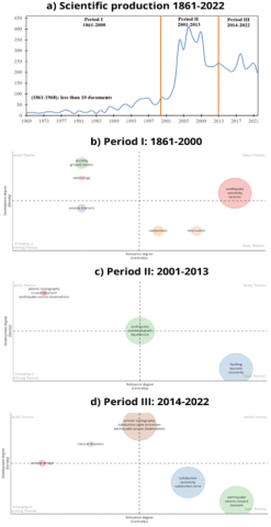
3.1 Scientific production and thematic evolution
Figure 3(a) shows the scientific production between 1861 and 2022, resulting in 6553 documents. The figure shows exponential growth from 2001 to 2009. During 1861-1968, there were only ten documents per year, so this figure starts from 1969. Additionally, the strategic diagrams shown in Figure 3(b)-Figure 3(d) consist of four quadrants described below:
Quadrant I: Motor Themes (upper right), topics with high density and centrality, with strong links to other topics in other quadrants.
Quadrant II: Niche, developed or isolated Themes (upper left), contains high density and low centrality themes.
Quadrant III: Emerging or declining Themes (lower left), including low-density and centrality themes.
Quadrant IV: Basic or transversal Themes (lower right), low density and high centrality themes, focusing on general transversal questions to the different research areas.
The circle size in these figures is proportional to each theme's total frequency of terms (author's keywords). Each theme is labelled with the corresponding three most frequent keywords.
Period I (1861-2000): The publications on EiA were reduced to only 1106 documents during these 131 years. It represented 16.87% of scientific production ver Figure 3(b). The terms identified as motor themes are: 'earthquake', 'seismicity', and 'tectonic' since the first publication on EiA was in 1861.
Period II (2001-2013): The publications on EiA increased during these 13 years, with 3410 documents representing 52.03% of the total publications on EIA. In this period, "seismic tomography", "crustal structure", and "earthquake source observations" were distinguished as niche themes, which represent the most developed themes see Figure 3(c).
Period III (2014-2022): There was a reduced contribution of publications on EiA during these last nine years, with 2037 documents representing 31.08% of the total publications on EiA. It was identified that the 'motor themes' of previous periods became 'basic or transcendental themes' in the subject, which are related to future lines of research such as "seismic design" see Figure 3(d).
Figure 3. Evolution of the scientific production: (a) publications during 1861-2022; (b-d) thematic maps about EIA
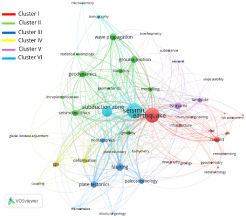
3.2 Co-ocurrence by author´s keywords
The co-occurrence analysis is a technique that allows an understanding of the relationship between the keywords that appear in a database of a field of study [61]. The process of this analysis is summarised in the steps described below:
(1) VOSviewer was used to represent the network, extracting 2100 authors' keywords from the database using the full counting method.
(2) VOSviewer thesaurus file: consists of a post-processing of the 2100 keywords extracted by using this file that includes two columns, i) 'label' containing the database keywords and ii) 'replace by' that includes terms to unify synonyms, plural words, acronyms, and erroneous words that are excluded from the analysis.
(3) Choose threshold: consist of selecting the minimum number of occurrences of a keyword. The threshold is based on the frequency by keyword. The recommended threshold is the appearance of at least five times.
As a result, 48 keywords met the threshold; they were distributed in six clusters according to their relation, represented by 353 links or connections, as shown in Figure 4.
The clusters represent an area of knowledge. Therefore, the number of clusters, the way they are grouped and their relevance were determined by considering the following factors i) the number of input keywords (in this case, 48), ii) the frequency of the keywords, which is reflected in the size of the circles of the bibliometric network; iii) the relationship of each term concerning another, which is measured by the links that are the coloured lines that connect each keyword and iv) the thickness of the links or total link strength, which represents the weight of the relationship between clusters, which is complemented by the distance between each node, with strongly related topics being those that are closer to each other. For example, Cluster I (red) and Cluster VI (light blue) are the most connected clusters in this bibliometric network, shown in Figure 4.
The resulting six clusters are described below, highlighting the most representative terms and related topics. The name of each cluster was assigned according to the terms with the highest frequency (occurrence), linking and analyzing the topics addressed by the cluster.
Figure 4. Co-ocurrence network by author´s keywords
Cluster I: 'Earthquakes and their infrastructure hazards' (red), where the most relevant term is 'earthquake', with 736 occurrences being the second most representative cluster. The studies focus on evaluating the risk of earthquakes concerning structural damage using Geographic Information Systems (GIS) and Remote Sensing techniques.
Cluster II: 'Geodynamics and wave propagation' (green), where the most relevant term is 'wave propagation' (148 occurrences). Studies in this cluster focus on interplate tectonic processes, ground motion, and seismotectonic through statistical analysis and modelling.
Cluster III: 'Faulting by plate tectonics activity' (blue), where the most relevant term is 'faulting' (182 occurrences). The studies focus on the movement of plate tectonics through structural geology, paleoseismology and neotectonics analyses.
Cluster IV: 'Global Positioning System (GPS) on deformation mapping' (yellow), where the most relevant term is 'GPS' (81 occurrences). Research in this cluster is related to plate boundaries, bathymetric analysis, and glacial isostatic adjustment.
Cluster V: 'Tsunamis and geological disasters' (violet), where the most relevant term is 'tsunami' (144 occurrences). The research evaluates geological disasters associated with tsunamis, such as landslides, slope stability, and subsidence, and studies with interferometry for seismic observations and sea level changes.
Cluster VI: 'Seismic on subduction zones' (light blue), where the most relevant term is 'seismic' (744 occurrences), the cluster's most representative. The studies focus on microseismicity, the application of tomography in subduction zones with high seismicity and microseismicity.
3.3 Countries contribution
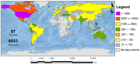
This analysis was performed in VOSviewer through the bibliometric network named 'bibliographic coupling by countries' and using a thesaurus file to remove wrong and duplicated countries' names. Additionally, the countries with at least one document on the EiA were the threshold, resulting in 97 countries. The spatial distribution and range of scientific publications are shown in Figure 5 using ArcGIS Pro.
The most relevant countries considering the number of documents, links or connections between them and citations are the following: i) USA with 3377 documents, ii) Mexico with 715 documents, and iii) Canada with 626 documents.
Figure 5. Worldwide contribution about EiA
3.4 Research trends
Figure 6 presents the analysis of research trends, including the frequency of the main terms that determined the evolution of EIA as a selected field of study. It was included as an analysis threshold that the keywords have a frequency greater than five and that they appeared at least three times per year. Two periods were analysed: i) 1861-2013 and ii) 2014-2022 due to many terms and to perform an in-depth analysis of the development and trends on EiA. However, in 1861-2013 Figure 6(a), the first record of keywords in scientific publications was observed in 1997.
Figure 6. Trends topics about EiA, a) period 1861-2013, y b) period 2014-2022
The longest study periods during the 1997-2013 period include the following topics: 'attenuation' (2004-2010), 'ductility' (1997-2008) and 'seismicity' (2002-2008). In the second period, 2014-2022, the topics with the longest study time are: 'time-series analysis', 'subduction zone processes', and 'earthquake'. The most frequent keywords are 'earthquake' (528), 'tsunami' (114), 'seismicity' (111), 'seismic hazard' (97) and 'faulting '(88). With this analysis, future research trends were identified based on the most studied topics in the last three years: 'ground motion' (13), 'ground motion model' (9) and 'seismic hazard' (15).
The evolution of the intellectual structure of EiA has developed over 161 years, where the peak in this subject has been evident mainly since 2002, with the contribution of scientific publications in Scopus and WoS from 97 countries, mainly in the American and Asian continent. Of the 6553 documents analyzed, 84.62% are scientific articles, 4.61% are conference papers, and the remaining correspond to other documents.
The evolution in publications of EiA was analysed through three periods: Period I (1861-2000), Period II (2001-2013), and Period III (2014-2022). The first document registered in the database was in 1861, with the study of Murray [49] about an earthquake in Argentina. However, the minimum number of scientific documents about EiA was during 1861-1968 because there were less than ten documents per year (16.87% of the 6553 documents). Publications during 1861-2000 were mainly related to earthquakes, seismicity and tectonics, recognised as motor themes Figure 3(b). The most relevant publication, according to the number of cites, was the study by DeMets et al. [15], published in 1990, where 1122 structural data were analysed (277 spreading rates, 121 transform fault azimuths, and 724 earthquake slip vectors), distributed in the limits of 12 tectonic plates.
During 2001-2013 there was an exponential growth in publications on EiA (52.03%). The motor themes identified were earthquakes, seismic hazards and liquefaction Figure 3(c). The increase in research during this period was related to the effects of climate change, the high frequency of catastrophic earthquakes, the growing population, poverty zones and the lack of mitigation plans and methodologies to reduce or correctly evaluate the effects of these events. Finally, during the last period (2014-2022), the following topics were identified as basic or transversal themes: earthquake, seismic hazard, subduction, seismicity, and tsunami, which shows the coherence and development of this field of study. The emerging topics are also aligned with seismic design Figure 3(d), related to the future research lines identified on the trend topics analysis (see Figure 6).
Bibliometric studies about earthquakes are uncommon due to the large data to process; usually, the software capacities do not allow it. However, there is a study about earthquake research during 1900-2010 [67], using only the WoS database through 84,051 publications and searching keywords “earthquake”, “seismology”, “seismic”, and “quake”. Therefore, this study focuses on catastrophic earthquakes in America in a way to analyse the emerging research areas deeply, the evolution of EiA and including two databases (WoS and Scopus) and bibliometric software (VOSviewer and Bibliometrix) for more coverage and identify the trend topics in this field.
Topics such as ground motion model, ground motion, seismic hazard, and seismic risk were identified as future research areas through the analysis of trend topics. It is closely related to the co-occurrence analysis by the author's keywords, where the most representative topics are: earthquakes, seismic, subduction zone, tsunami, and geodynamics.
This study focused on diagnosing scientific publications on catastrophic earthquakes in the American continent because of the high frequency of earthquakes due to its location on the western flank of the Pacific Ring of Fire, a subduction zone characterised by its active tectonism, which has generated human losses, structural damage and a strong psychosocial impact on those affected by earthquakes. Therefore, this study can be replicated in future global or regional studies since knowing the nature of the earthquakes, poverty, growing population, inadequate territorial planning, and seismic-resistant infrastructures. Consequently, decision-makers can propose mitigation plans for the impacts caused by earthquakes, applying methodologies validated by the scientific community, such as ground motion models, induced seismicity, and seismic hazard.
The scientific production on EiA in the period 1861-2022 was analysed, with 6553 documents, using the science mapping technique with four bibliometric networks described below:
(1) Thematic evolution: It determined that the origin of EiA research was in 1861, and its development was evaluated in three periods: i) 1861-2000 (constant), ii) 2001-2013 (increasing), and iii) 2014-2022 (driving theme, reduction in scientific production) (Figure 3).
(2) Co-occurrence by author´s keywords: The intellectual structure on EiA was recognised based on the processing of 2100 keywords, represented by 48 nodes and six clusters oriented to structural risks, geodynamics, faulting, deformation mapping, tsunamis, and seismicity (Figure 4).
(3) Bibliographic coupling by countries: It was used for the spatial representation of the 97 countries that contributed to the scientific production of EiA on the western flank of the Pacific Ring of Fire (Figure 5).
(4) Trend topics: It allowed the recognition of future research topics oriented to ground motion models and seismic risk (Figure 6).
Scientific publications on EiA have developed progressively during the analysis period (1861-2022). Between 1861 and 1999, scientific production was scarce. Since 2000, apogee began, led by the USA, Canada, and China, with collaborations from countries in the central-southern part of the American continent. Since 2014, the topic of earthquakes has become a driving force of great importance. In the last nine years (2014-2022), collaborations from the following countries stood out: Mexico, France, Guatemala, and Chile.
The limitations of this study include: i) the exclusion of earthquakes originating from volcanic activity and ii) the delimitation of publications on earthquakes from the western limit of the American continent since there would not be a global analysis of each continent for a better understanding of the origin and consequences of earthquakes worldwide. However, this study represents a baseline for future research; for example, worldwide earthquakes analysis including all magnitudes and effects, showing the connections among geography, plate tectonic activity, vulcanism, growing population, climate change and poverty as predictors for mitigation plans for these kinds of phenomena.
This work is supported by the following projects: (i) ´Registro del Patrimonio Geológico y Minero y su incidencia en la defensa y preservación de la geodiversidad en Ecuador´ (Registry of Geological and Mining Heritage and its impact on the defense and preservation of geodiversity in Ecuador), with code No. CIPAT-01-2018, y (ii) ´Gestión y Evaluación de la Investigación Científica en Ciencias de la Tierra, Economía, Administración y sus vínculos con la sociedad´ (Management and Evaluation of Scientific Research in Earth Sciences, Economy, Administration and its links with Society), with code No. CIPAT-7-2022.
[1] Adushkin, V.V. (2016). Tectonic earthquakes of anthropogenic origin. Izvestiya, Physics of the Solid Earth, 52: 173-194. https://doi.org/10.1134/S1069351316020014
[2] Anderson, J.G., Bodin, P., Brune, J.N., Prince, J., Singh, S.K., Quaas, R., Onate, M. (1986). Strong ground motion from the michoacan, mexico, earthquake. Science, 233(4768): 1043-1049. https://doi.org/10.1126/science.233.4768.1043
[3] Aria, M., Cuccurullo, C. (2017). Bibliometrix: An R-tool for comprehensive science mapping analysis. Journal of Informetrics, 11(4): 959-975. https://doi.org/10.1016/j.joi.2017.08.007
[4] Gómez, J.C., Tavera, H.J., Orihuela, N. (2005). Soil liquefaction during the Arequipa Mw 8.4, June 23, 2001 earthquake, southern coastal Peru. Engineering Geology, 78(3-4): 237-255. https://doi.org/10.1016/j.enggeo.2004.12.007
[5] Barazangi, M., Isacks, B.L. (1976). Spatial distribution of earthquakes and subduction of the nazca plate beneath South America. Geology, 4(11): 686-692. https://doi.org/10.1130/0091-7613(1976)4%3C686:SDOEAS%3E2.0.CO;2
[6] Basu, T., Das, A. (2020). Identification of backward district in India by applying the principal component analysis and fuzzy approach: A census based study. Socio-Economic Planning Sciences, 72: 100915. https://doi.org/10.1016/j.seps.2020.100915
[7] Baudino, R., Hermoza, W. (2014). Subduction consequences along the Andean margin: Thermal and topographic signature of an ancient ridge subduction in the Marañón Basin of Perú. Geologica Acta, 287-306. https://doi.org/10.1344/GeologicaActa2014.12.4.2
[8] Bilham, R. (2010). Lessons from the Haiti earthquake. Nature, 463(7283): 878-879. https://doi.org/10.1038/463878a
[9] Boehler, R. (2000). High‐pressure experiments and the phase diagram of lower mantle and core materials. Reviews of Geophysics, 38(2): 221-245. https://doi.org/10.1029/1998RG000053
[10] Bommer, J.J., Benito, M.B., Ciudad-Real, M., Lemoine, A., López-Menjı́var, M.A., Madariaga, R., Mankelow, J., Méndez de Hasbun, P., Murphy, W., Nieto-Lovo, M., Rodrı́guez-Pineda, C.E., Rosa, H. (2002). The El salvador earthquakes of january and february 2001: Context, characteristics and implications for seismic risk. Soil Dynamics and Earthquake Engineering, 22(5): 389-418. https://doi.org/10.1016/S0267-7261(02)00024-6
[11] Boore, D.M. (2003). Simulation of ground motion using the stochastic method. Pure and Applied Geophysics, 160: 635-676. https://doi.org/10.1007/PL00012553
[12] Cammarano, F., Goes, S., Vacher, P., Giardini, D. (2003). Inferring upper-mantle temperatures from seismic velocities. Physics of the Earth and Planetary Interiors, 138(3-4): 197-222. https://doi.org/10.1016/S0031-9201(03)00156-0
[13] Carrión-Mero, P., Montalván-Burbano, N., Herrera-Franco, G., Domínguez-Granda, L., Bravo-Montero, L., Morante-Carballo, F. (2022). Research trends in groundwater and stable isotopes. Water, 14(19): 3173. https://doi.org/10.3390/w14193173
[14] Chunga, K., Livio, F., Mulas, M., Ochoa‐Cornejo, F., Besenzon, D., Ferrario, M.F., Michetti, A.M. (2018). Earthquake ground effects and intensity of the 16 April 2016 Mw 7.8 pedernales, ecuador, earthquake: Implications for the source characterization of large subduction earthquakes. Bulletin of the Seismological Society of America, 108(6): 3384-3397. https://doi.org/10.1785/0120180051
[15] DeMets, C., Gordon, R.G., Argus, D.F., Stein, S. (1990). Current plate motions. Geophysical Journal International, 101(2): 425-478. https://doi.org/10.1111/j.1365-246X.1990.tb06579.x
[16] Dominković, D.F., Weinand, J.M., Scheller, F., D'Andrea, M., McKenna, R. (2022). Reviewing two decades of energy system analysis with bibliometrics. Renewable and Sustainable Energy Reviews, 153: 111749. https://doi.org/10.1016/j.rser.2021.111749
[17] Donthu, N., Kumar, S., Mukherjee, D., Pandey, N., Lim, W.M. (2021). How to conduct a bibliometric analysis: An overview and guidelines. Journal of Business Research, 133: 285-296. https://doi.org/10.1016/j.jbusres.2021.04.070
[18] Dziewonski, A.M., Lekic, V., Romanowicz, B.A. (2010). Mantle anchor structure: An argument for bottom up tectonics. Earth and Planetary Science Letters, 299(1-2): 69-79. https://doi.org/10.1016/j.epsl.2010.08.013
[19] Ellsworth, W.L. (2013). Injection-induced earthquakes. Science, 341(6142): 1225942. https://doi.org/10.1126/science.1225942
[20] Endo, Y., Pelà, L., Roca, P., Da Porto, F., Modena, C. (2015). Comparison of seismic analysis methods applied to a historical church struck by 2009 L’Aquila earthquake. Bulletin of Earthquake Engineering, 13(12): 3749-3778. https://doi.org/10.1007/s10518-015-9796-0
[21] ESRI. (2022). ArcGIS desktop. Environmental Systems Research Institute; ESRI. https://www.esri.com/en-us/arcgis/products/arcgis-pro/overview
[22] Fuis, G.S., Clayton, R.W., Davis, P.M., Ryberg, T., Lutter, W.J., Okaya, D.A., Hauksson, E., Prodehl, C., Murphy, J.M., Benthien, M.L., Baher, S.A., Kohler, M.D., Thygesen, K., Simila, G., Keller, G.R. (2003). Fault systems of the 1971 san fernando and 1994 northridge earthquakes, southern California: Relocated aftershocks and seismic images from LARSE II. Geology, 31(2): 171-174. https://doi.org/10.1130/0091-7613(2003)031%3C0171:FSOTSF%3E2.0.CO;2
[23] Geist, E.L., Lou Zoback, M. (1999). Analysis of the tsunami generated by the Mw 7.8 1906 san francisco earthquake. Geology, 27(1): 15-18. https://doi.org/10.1130/0091-7613(1999)027%3C0015:AOTTGB%3E2.3.CO;2
[24] Goes, S.D., Velasco, A.A., Schwartz, S.Y., Lay, T. (1993). The April 22, 1991, Valle de la Estrella, Costa Rica (Mw=7.7) earthquake and its tectonic implications: A broadband seismic study. Journal of Geophysical Research: Solid Earth, 98(B5): 8127-8142. https://doi.org/10.1029/93JB00019
[25] Hallinger, P., Nguyen, V.T. (2020). Mapping the landscape and structure of research on education for sustainable development: A bibliometric review. Sustainability, 12(5): 1947. https://doi.org/10.3390/su12051947
[26] Hernández-Torrano, D., Somerton, M., Helmer, J. (2022). Mapping research on inclusive education since salamanca statement: A bibliometric review of the literature over 25 years. International Journal of Inclusive Education, 26(9): 893-912. https://doi.org/10.1080/13603116.2020.1747555
[27] Herrera-Franco, G., Bollmann, H.A., Lofhagen, J.C.P., Bravo-Montero, L., Carrión-Mero, P. (2023). Approach on water-energy-food (WEF) nexus and climate change: A tool in decision-making processes. Environmental Development, 46: 100858. https://doi.org/10.1016/j.envdev.2023.100858
[28] Herrera-Franco, G., Carrión-Mero, P., Montalván-Burbano, N., Mora-Frank, C., Berrezueta, E. (2022). Bibliometric analysis of groundwater’s life cycle assessment research. Water, 14(7): 1082. https://doi.org/10.3390/w14071082
[29] Herrera-Franco, G., Montalván-Burbano, N., Mora-Frank, C., Bravo-Montero, L. (2021). Scientific research in Ecuador: A bibliometric analysis. Publications, 9(4): 55. https://doi.org/10.3390/publications9040055
[30] Herrera-Franco, G., Montalván-Burbano, N., Mora-Frank, C., Moreno-Alcívar, L. (2021). Research in petroleum and environment: A bibliometric analysis in south America. International Journal of Sustainable Development & Planning, 16(6): 1109-1116. https://doi.org/10.18280/ijsdp.160612
[31] Kalkbrenner, P., Pelà, L., Sandoval, C. (2019). Multi directional pushover analysis of irregular masonry buildings without box behavior. Engineering Structures, 201: 109534. https://doi.org/10.1016/j.engstruct.2019.109534
[32] Komperda, R. (2017). Likert-type survey data analysis with R and RStudio. In Computer-Aided Data Analysis in Chemical Education Research (CADACER). Advances and Avenues American Chemical Society, pp. 91-116. https://doi.org/10.1021/bk-2017-1260.ch007
[33] Lange, D., Ruiz, J., Carrasco, S., Manríquez, P. (2018). The Chiloé M w 7.6 earthquake of 2016 December 25 in southern chile and its relation to the M w 9.5 1960 valdivia earthquake. Geophysical Journal International, 213(1): 210-221. https://doi.org/10.1093/gji/ggx514
[34] Leor, J., Poole, W.K., Kloner, R.A. (1996). Sudden cardiac death triggered by an earthquake. New England Journal of Medicine, 334(7): 413-419. https://doi.org/10.1056/NEJM199602153340701
[35] Liu, W., Yao, H. (2020). Rupture process of the 26 May 2019 Mw 8.0 northern Peru intermediate‐depth earthquake and insights into its mechanism. Geophysical Research Letters, 47(4): e2020GL087167. https://doi.org/10.1029/2020GL087167
[36] Lomax, A. (2005). A reanalysis of the hypocentral location and related observations for the great 1906 California earthquake. Bulletin of the Seismological Society of America, 95(3): 861-877. https://doi.org/10.1785/0120040141
[37] Lomax, A. (2008). Location of the focus and tectonics of the focal region of the california earthquake of 18 April 1906. Bulletin of the Seismological Society of America, 98(2): 846-860. https://doi.org/10.1785/0120060405
[38] Lomnitz, C. (2004). Major earthquakes of Chile: A historical survey, 1535-1960. Seismological Research Letters, 75(3): 368-378. https://doi.org/10.1785/gssrl.75.3.368
[39] López-Illescas, C., de Moya-Anegón, F., Moed, H.F. (2008). Coverage and citation impact of oncological journals in the web of science and scopus. Journal of Informetrics, 2(4): 304-316. https://doi.org/10.1016/j.joi.2008.08.001
[40] Lorito, S., Piatanesi, A., Lomax, A. (2008). Rupture process of the 18 April 1906 California earthquake from near-field tsunami waveform inversion. Bulletin of the Seismological Society of America, 98(2): 832-845. https://doi.org/10.1785/0120060412
[41] Maia, S.C., de Benedicto, G.C., do Prado, J.W., Robb, D.A., de Almeida Bispo, O.N., de Brito, M.J. (2019). Mapping the literature on credit unions: A bibliometric investigation grounded in scopus and web of science. Scientometrics, 120: 929-960. https://doi.org/10.1007/s11192-019-03165-1
[42] Martínez-Díaz, J.J., Alvarez-Gómez, J.A., Benito, B., Hernández, D. (2004). Triggering of destructive earthquakes in El Salvador. Geology, 32(1): 65-68. https://doi.org/10.1130/G20089.1
[43] Mas-Tur, A., Kraus, S., Brandtner, M., Ewert, R., Kürsten, W. (2020). Advances in management research: A bibliometric overview of the review of managerial science. Review of Managerial Science, 14: 933-958. https://doi.org/10.1007/s11846-020-00406-z
[44] Meltzner, A.J., Wald, D.J. (2003). Aftershocks and triggered events of the great 1906 California earthquake. Bulletin of the Seismological Society of America, 93(5): 2160-2186. https://doi.org/10.1785/0120020033
[45] Mendoza, M.J., Auvinet, G. (1988). The Mexico earthquake of September 19, 1985-behavior of building foundations in Mexico City. Earthquake Spectra, 4(4): 835-853. https://doi.org/10.1193/1.1585505
[46] Moral-Muñoz, J.A., Herrera-Viedma, E., Santisteban-Espejo, A., Cobo, M.J. (2020). Software tools for conducting bibliometric analysis in science: An up-to-date review. Profesional de la Información, 29(1). https://doi.org/10.3145/epi.2020.ene.03
[47] Morante-Carballo, F., Montalván-Burbano, N., Arias-Hidalgo, M., Domínguez-Granda, L., Apolo-Masache, B., Carrión-Mero, P. (2022). Flood models: An exploratory analysis and research trends. Water, 14(16): 2488. https://doi.org/10.3390/w14162488
[48] Morante-Carballo, F., Montalván-Burbano, N., Quiñonez-Barzola, X., Jaya-Montalvo, M., Carrión-Mero, P. (2022). What do we know about water scarcity in semi-arid zones? A global analysis and research trends. Water, 14(17): 2685. https://doi.org/10.3390/w14172685
[49] Murray, C. (1861). Notice of the occurrence of an earthquake on the 20th of March, 1861, in Mendoza, Argentine Confederation, South America. Quarterly Journal of the Geological Society, 17(1-2): 553-553. https://doi.org/10.1144/GSL.JGS.1861.017.01-02.49
[50] Paulatto, M., Laigle, M., Galve, A., Charvis, P., Sapin, M., Bayrakci, G., Evain, M., Kopp, H. (2017). Dehydration of subducting slow-spread oceanic lithosphere in the Lesser Antilles. Nature Communications, 8(1): 15980. https://doi.org/10.1038/ncomms15980
[51] Pech, G., Delgado, C. (2020). Assessing the publication impact using citation data from both Scopus and WoS databases: An approach validated in 15 research fields. Scientometrics, 125(2): 909-924. https://doi.org/10.1007/s11192-020-03660-w
[52] Protti, M., Schwartz, S.Y. (1994). Mechanics of back arc deformation in Costa Rica: Evidence from an aftershock study of the April 22, 1991, Valle de la Estrella, Costa Rica, earthquake (Mw=7.7). Tectonics, 13(5): 1093-1107. https://doi.org/10.1029/94TC01319
[53] White, R.A., Harlow, D.H. (1993). Destructive upper-crustal earthquakes of central America since 1900. Bulletin of the Seismological Society of America, 83(4): 1115-1142. https://doi.org/10.1785/BSSA0830041115
[54] Ranero, C.R., Phipps Morgan, J., McIntosh, K., Reichert, C. (2003). Bending-related faulting and mantle serpentinization at the middle America trench. Nature, 425(6956): 367-373. https://doi.org/10.1038/nature01961
[55] Ravikumar, S., Agrahari, A., Singh, S.N. (2015). Mapping the intellectual structure of scientometrics: A co-word analysis of the journal scientometrics (2005-2010). Scientometrics, 102: 929-955. https://doi.org/10.1007/s11192-014-1402-8
[56] Ruiz, S., Moreno, M., Melnick, D., Del Campo, F., Poli, P., Báez, J.C., Leyton, F., Madariaga, R. (2017). Reawakening of large earthquakes in south central Chile: The 2016 Mw 7.6 Chiloé event. Geophysical Research Letters, 44(13): 6633-6640. https://doi.org/10.1002/2017GL074133
[57] Sánchez, A.D., Del Río, M.D.L.C., García, J.Á. (2017). Bibliometric analysis of publications on wine tourism in the databases Scopus and WoS. European Research on Management and Business Economics, 23(1): 8-15. https://doi.org/10.1016/j.iedeen.2016.02.001
[58] Seed, H.B., Romo, M.P., Sun, J.I., Jaime, A., Lysmer, J. (1988). The mexico earthquake of September 19, 1985-Relationships between soil conditions and earthquake ground motions. Earthquake Spectra, 4(4): 687-729. https://doi.org/10.1193/1.1585498
[59] Sirunyan, A.M., Tumasyan, A., Adam, W., Asilar, E., Bergauer, T., Brandstetter, J., et al. (2017). Search for dark matter produced with an energetic jet or a hadronically decaying W or Z boson at √s=13 TeV Journal of High Energy Physics, 2017(7): 1-50. https://doi.org/10.1007/JHEP07(2017)014
[60] Suárez, G., Ruiz‐Barón, D., Chico‐Hernández, C., Zúñiga, F.R. (2020). Catalog of preinstrumental earthquakes in central Mexico: Epicentral and magnitude estimations based on macroseismic data. Bulletin of the Seismological Society of America, 110(6): 3021-3036. https://doi.org/10.1785/0120200127
[61] Tan, H., Li, J., He, M., Li, J., Zhi, D., Qin, F., Zhang, C. (2021). Global evolution of research on green energy and environmental technologies: A bibliometric study. Journal of Environmental Management, 297: 113382. https://doi.org/10.1016/j.jenvman.2021.113382
[62] Van Eck, N., Waltman, L. (2010). Software survey: VOSviewer, a computer program for bibliometric mapping. Scientometrics, 84(2): 523-538. https://doi.org/10.1007/s11192-009-0146-3
[63] Van Eck, N.J., Waltman, L. (2014). Visualizing bibliometric networks. In Measuring Scholarly Impact: Methods and Practice. Cham: Springer International Publishing, pp. 285-320. https://doi.org/10.1007/978-3-319-10377-8_13
[64] Xie, Y., Ji, L., Zhang, B., Huang, G. (2018). Evolution of the scientific literature on input-output analysis: A bibliometric analysis of 1990-2017. Sustainability, 10(9): 3135. https://doi.org/10.3390/su10093135
[65] Ye, L., Kanamori, H., Avouac, J.P., Li, L., Cheung, K.F., Lay, T. (2016). The 16 April 2016, MW 7.8 (MS 7.5) ecuador earthquake: A quasi-repeat of the 1942 MS 7.5 earthquake and partial re-rupture of the 1906 MS 8.6 Colombia-Ecuador earthquake. Earth and Planetary Science Letters, 454: 248-258. https://doi.org/10.1016/j.epsl.2016.09.006
[66] Youd, T.L., Idriss, I.M. (2001). Liquefaction resistance of soils: Summary report from the 1996 NCEER and 1998 NCEER/NSF workshops on evaluation of liquefaction resistance of soils. Journal of Geotechnical and Geoenvironmental Engineering, 127(4): 297-313. https://doi.org/10.1061/(ASCE)1090-0241(2001)127:4(297)
[67] Yu, Y., Jin, Z., Qiu, J. (2021). Global isotopic hydrograph separation research history and trends: A text mining and bibliometric analysis study. Water, 13(18): 2529. https://doi.org/10.3390/w13182529